Development of a Geotechnical Asset Management Program for … · 2019-12-16 · Development of a...
15
Development of a Geotechnical Asset Management Program for the New Brunswick of Transportation and Infrastructure Jared McGinn, Research Engineer, New Brunswick Department of Transportation and Infrastructure (NBDTI) Serge T. Dupuis, ing., MBA, M.Sc., Professeur, Département de génie civil, Faculté d’ingénierie Université de Moncton Philippe Goguen, Summer Engineering Student NBDTI, Université de Moncton Reilly Parsons, Summer Engineering Student NBDTI, University of New Brunswick Paper prepared for presentation at the Innovations in Asset Management Session of the 2018 Annual Conference of the Transportation Association of Canada Saskatoon, SK
Transcript of Development of a Geotechnical Asset Management Program for … · 2019-12-16 · Development of a...

Development of a Geotechnical Asset Management Program for the New Brunswick of Transportation and Infrastructure
Jared McGinn, Research Engineer, New Brunswick Department of Transportation and Infrastructure (NBDTI)
Serge T. Dupuis, ing., MBA, M.Sc., Professeur, Département de génie civil, Faculté d’ingénierie
Université de Moncton
Philippe Goguen, Summer Engineering Student NBDTI, Université de Moncton
Reilly Parsons, Summer Engineering Student NBDTI,
University of New Brunswick
Paper prepared for presentation at the Innovations in Asset Management Session of the 2018 Annual Conference of the
Transportation Association of Canada Saskatoon, SK

1
ABSTRACT A large portion of highways in New Brunswick are adjacent to streams, rivers, lakes, and ocean waters. Erosion and instability can occur due to shifting water ways, ice scour, and sea level rise. Geotechnical assets affected by these environmental conditions could not be efficiently managed using traditional methods. During the summer of 2017, a Geotechnical Asset Management (GAM) program was developed by the New Brunswick Department of Infrastructure (NBDTI) and the Université de Moncton (UdeM). The purpose of the GAM program is to catalogue the geotechnical assets and their conditions, and prioritize repair efforts. Over 400 km of road within New Brunswick was selected for the trial. All embankments along these routes were evaluated and ranked according to their condition. It was concluded that the GAM method for collecting geotechnical data was effective when comparing conditions of many sections of embankments along roadways that are experiencing erosion or instability of the road embankment.

2018 TAC Conference & Exhibition-Saskatoon, SK 2
Introduction Asset management is the integration of finance, planning, personnel, and information management, enabling agencies to manage asset cost more effectively. It is a systematic process that combines engineering principles, business practices, and economic rational with the goal of allocating funds among an agency’s assets, so that the best return on the investment is obtained (Krugler et al. 2007). Public transportation networks of most countries are the most valuable publicly owned infrastructure; therefore, its continuous and safe operation is essential. Transportation Asset Management (TAM) is the application of asset management principles to transportation infrastructure. The goal of TAM is to sustain a state of adequate condition and develop cost effective repair decisions over the infrastructures service life (Sinha et al. 2017). Previously, each transportation aspect (structures, road surfaces, and geotechnical assets) was managed separately. Recently, there has been a shift towards Cross Asset Management, which considers the total transportation infrastructure. Cross Asset Management is a holistic approach that considers all possible parameters and interactions between subsystems, allowing for a more efficient use of resources (Deix et al. 2012). Cross Asset management is not possible without a strong asset management program for every subsystem of the transportation infrastructure. As TAM tools and concepts have developed, little attention has been paid to geotechnical assets. Most efforts have been isolated and limited, often consisting of only inventory while stopping short of applying the full TAM process. GAM should, however, be a significant area of focus, as every transportation asset rest on or is affected by a geotechnical asset (Stanley 2011). Internationally, GAM programs have increased in popularity and are being implemented by governments and Departments of Transportation (DOT). A GAM trial was implemented in Japan (Ohta et al. 2009) to inspect a roadway which was built on a soft clay. It was possible to successfully perform lifecycle predictions based on finite element analysis demonstrating that numerical modeling could be efficient in GAM programs. In Great Britain, GAM programs have been gaining momentum, with several trials being conducted. There is currently a high failure rate of earthwork rail assets in Great Britain, leading to the development of an evidence-based GAM policy (Power et al. 2016). An integrated method was developed to determine the likelihood of failure, consequences, and appropriate intervention, along with a strategic, whole-life cost Decision Support Tool (DST) to model and optimize policy. The United Kingdom Department of Transportation (Bristol Highways Agency) performed a study to explore the challenges associated with climate change, analyzing the direct and indirect impacts climate change imposes on geotechnical assets and how to incorporate these effects into a GAM program (Patterson, n.d.). Interest in GAM has increased in the United States (US). Most US GAM programs have evolved from rock fall hazard rating systems in the early 1990s now include all aspects of geotechnical assets (Vessely 2017). Escobar et. al.(2014) conducted a national survey in the US to determine the state of GAM initiatives across the country. It was found that the majority of agencies are mature enough to develop GAM programs as they have completed inventories of geotechnical assets. However, most agencies indicated that inspection and maintenance were only conducted when assets were damaged, or when failure was immanent (Escobar-wolf et al. 2014). The Colorado DOT developed a wall asset management program (Walters and Vessely n.d.) with a coding guide based on their bridge inspection program, which enabled a consistency of reporting between asset management programs. A mobile app based data collection and data management system was used and risk was incorporated into the asset management program to enable the most efficient use of resources. In Alaska, geotechnical

2018 TAC Conference & Exhibition-Saskatoon, SK 3
assets are valued at $19.7 billion, 3 times the value of the bridge inventory, making geotechnical assets a high priority of the Alaskan DOT. A GAM program was implemented by incorporating baselines asset inventories into a GIS platform. A GAM framework was then developed along with tools for tracking the performance of the assets over time (Benko n.d.). The NBDTI has a well-established and successful asset management program for structures and road surfaces; however, there is currently no GAM program. New Brunswick is particularly susceptible to the effects of climate change and sea level rise due to its costal environments and many waterways, resulting in erosion and instability of geotechnical assets. Many roads in New Brunswick follow rivers and coastlines; therefore, they’re under direct threat from high water levels, ice scour, and changes to road surface. In New Brunswick, there are six NBDTI District offices that maintain the transportation infrastructure. Requests for repair designs are made by the District Engineer to NBDTI’s design branch where they are tabulated and entered into a three-year maintenance plan for projects. It is essential that standardized methods for evaluating geotechnical assets via a GAM program is developed to ensure that the correct projects are being prioritized and that resources are being efficiently utilized. Not only will a GAM program result in an efficient management of geotechnical assets, it will lay the foundation for a future cross asset management program. The goal of this study is to develop a data driven geotechnical inspection program which could be used to complete a baseline inventory of assets and standardize inspection practices across the 6 Districts. A trial inspection program was carried out on routes selected by District Engineers. This trial was conducted to evaluate the effectiveness of the proposed methods. To follow current asset management practices, the trial was developed in collaboration with the UdeM Civil Engineering Department. Technical Background To develop an asset management program, all agency assets must be well-defined. To ensure that appropriate geotechnical assets were selected, the Federal Highway Association (FHA) Geotechnical Asset Risk Cube was reviewed (Rivers 2015). The risk cube in Figure 1 outlines the range of geotechnical assets currently being investigated by other departments globally. These assets include: Retaining Walls, Slopes, Embankments, and Subgrade. It also includes performance goals and risk sources. Upon analyzing the combination of these assets with respect to New Brunswick’s topography, it was determined that embankments are the primary assets to investigate.

2018 TAC Conference & Exhibition-Saskatoon, SK 4
Figure 1: Federal Highway Association Geotechnical Asset Risk Cube
. Due to the proximity of New Brunswick’s roads near rivers, each year, the spring freshet causes erosion and deterioration of roads. When rivers wash away parts of the embankment, roads become unsafe for transportation. This leads to annual road closures and expensive repair costs. The GAM program was introduced to classify all embankments as assets, create an accessible catalog and prevent possible failures. The catalog provides condition assessments of the assets based on their risk sources and performance goals outlined in the Risk Cube. The risk source and performance goals are relevant to the project because they include physical failures such as, natural hazards, safety, and traffic congestion. The catalogue will make it easier to identify areas prone to geotechnical failure and assign maintenance. It also provides information about roads that have no previous records, and gives an indication of their condition. Physical properties of embankments were recorded to determine if performance goals can be met. To measure these properties, a simple list of equipment was required. A hand level and a measuring tape were used to find elevations, horizontal distances and slopes. A handheld Global Positioning System (GPS) was used to geo-reference the assets and create an interactive map using Arc Map. In addition, a camera was used on site to collect photos of damaged features and capture evidence of instability for each embankment.

2018 TAC Conference & Exhibition-Saskatoon, SK 5
To understand what features to observe and record, a standardized inspection sheet was created. The inspection sheet was tailored to include physical properties of the embankment, along with all other indicators of failure to give an overall assessment. The following assessment includes:
Field Rating Estimate Pavement Distress
Location Information Road Relocation Options
Section Length Detour Length if Section Failed
Soil Type Surface and Groundwater Characteristics
Slope Geometry Guiderail Conditions
Width of Asphalt and Shoulder Residential Density
Each asset had an inspection sheet filled and data was entered into a central database. This data base implements the ranking system model. The ranking system starts by assigning an A-F rating for every element of a given asset. These ratings are then converted to a number system of exponential scale with a base of 2 as per the Rock Fall Hazard Rating Systems (FHWA 1993). This system permits an overall assessment by emphasizing the bad elements with elevated scores. When elements with high scores are repaired, it will ensure that assigned maintenance will change the overall grade of assets. Some elements of data collected were deemed to be more crucial than others. Elements 1 thru 6 of Figure 2 were more critical than elements 7 thru 14. For the model to reflect this, the system doubles the score of elements 1 thru 6 during the conversion. Once all the categories are scored individually, they are all added up for each site and given a final score. For these final scores, a high score translates to a poor condition site. These final scores are then converted back to A-F ratings to ease the comprehensibility of the final overall site rating.
Figure 2: Letter ranking grade chart that was used for assessments in the field

2018 TAC Conference & Exhibition-Saskatoon, SK 6
Unmanned Aerial Vehicle (UAV) UAV photogrammetry was used to monitor embankments with sub-par conditions. The images create 3D models that captures the current condition as a baseline for comparing future embankment condition. Figures 3 and 4 are examples of UAV images taken of an asset along route 105.
Figure 3: UAV Mesh Model of Route 105 embankment facing South
Figure 4: UAV Mesh Model of Route 105 embankment facing North

2018 TAC Conference & Exhibition-Saskatoon, SK 7
Geotechnical Asset Management Trial District Engineers from across the province are responsible for maintenance of embankments and roads. The engineers provided locations of sections of highways to be evaluated. The criteria for route selection were as follows;
• Evidence of embankment instability • Embankment erosion • Loss of shoulder, including failing guide rail • Pavement distress
Based on the recommendations provided, New Brunswick route 105 was selected. This road follows the east bank of the Saint John River, which is a section of highway that is affected by flooding annually. Embankment failure in this region causes major detours for commuters. As part of the trial, a group of 2 NBDTI engineering students inspected the road until a potential hazardous feature was spotted. These hazardous features included:
• Embankment height • Slope gradient • Evidence of slope instability • Other safety considerations
After preliminary reconnaissance, the first steps in geotechnical field investigations were determining the coordinates of the site. While one of the students collected geo-data, the other measured the width of the road and shoulders, inspected the guide rail and road conditions, and took notes on the slope geometry. Using a measuring tape and an eye level, students were able to determine the embankment height and slope gradient. Figure 5 depicts all sections of routes assessed in the GAM 2017 trial.

2018 TAC Conference & Exhibition-Saskatoon, SK 8
Figure 5: Routes that were assessed in New Brunswick, Canada
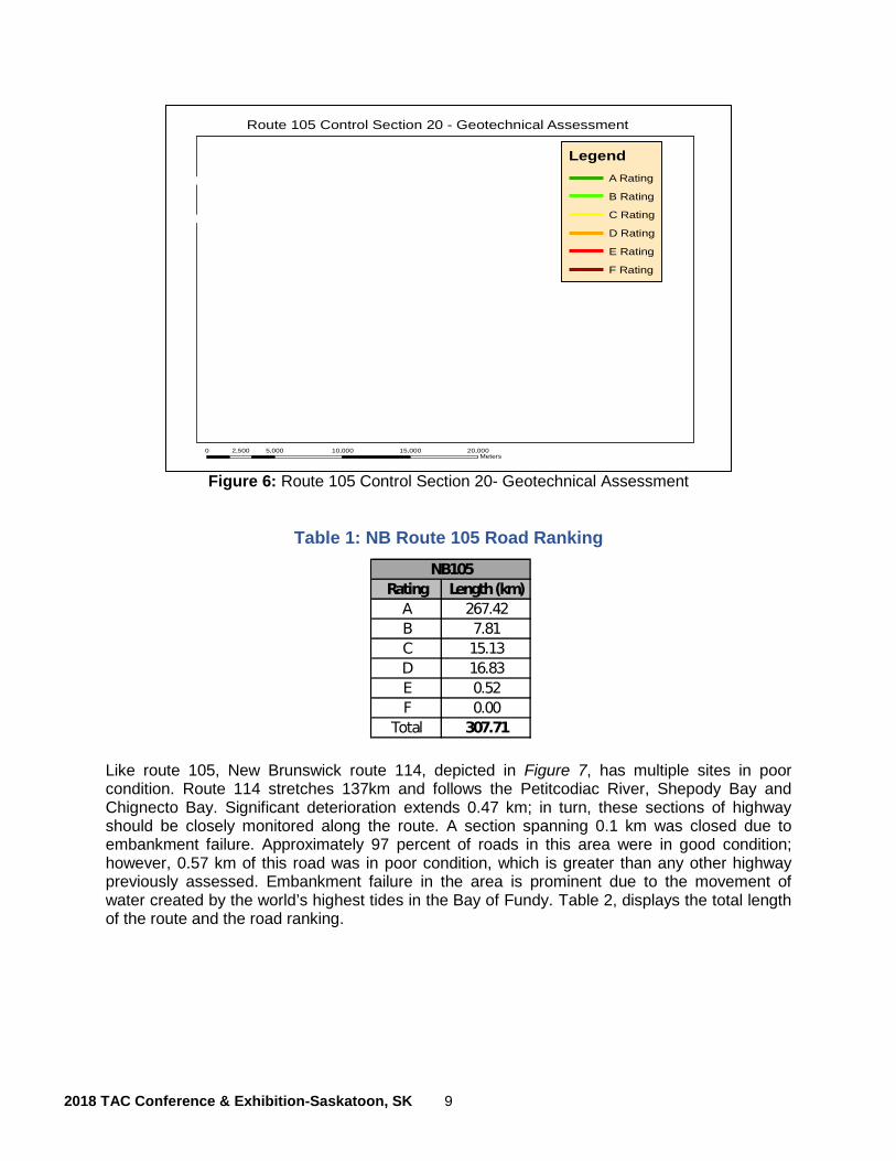
Results and Discussion Sections of highway along New Brunswick route 105, shown in Figure 6, were ranked very poorly. 5% of the highway was determined to have moderate to poor conditions. Based on the assessment, it is recommended that embankments are closely monitored. Route 105 is an important link between rural communities and a major concern for public safety. Sections ranked in very good condition were generally set back from the river floodplain. Poor conditions were seen where the road embankment was not designed to withstand the forces of the spring freshet. Table 1 displays the total length of the route and the road ranking. Based on the data collected from the GPS coordinates and inspection sheets, an interactive map was made using ArcGIS. Figure 6 displays the section of Route 105 and its associated road condition. The change in color represents the change in ratings between assets. As shown in Figure 6, a section with any rating can be found. Each section has a unique ID that is associated with the characteristics found in the field. As the road gets closer to the river, the color displayed on the map typically gets worst (yellow, orange, and red). Roads that have ‘A’ ratings are typically further away from the moving water. These colors are inclined to change from year to year due to flooding of the Saint John River.
2018 TAC Conference & Exhibition-Saskatoon, SK 9
Figure 6: Route 105 Control Section 20- Geotechnical Assessment
Table 1: NB Route 105 Road Ranking
Like route 105, New Brunswick route 114, depicted in Figure 7, has multiple sites in poor condition. Route 114 stretches 137km and follows the Petitcodiac River, Shepody Bay and Chignecto Bay. Significant deterioration extends 0.47 km; in turn, these sections of highway should be closely monitored along the route. A section spanning 0.1 km was closed due to embankment failure. Approximately 97 percent of roads in this area were in good condition; however, 0.57 km of this road was in poor condition, which is greater than any other highway previously assessed. Embankment failure in the area is prominent due to the movement of water created by the world’s highest tides in the Bay of Fundy. Table 2, displays the total length of the route and the road ranking.
Esri, HERE, Garmin, © OpenStreetMap contributors, and the GIS user community, Source: Esri,DigitalGlobe, GeoEye, Earthstar Geographics, CNES/Airbus DS, USDA, USGS, AeroGRID, IGN,and the GIS User Community
Route 105 Control Section 20 - Geotechnical Assessment
LegendA Rating
B Rating
C Rating
D Rating
E Rating
F Rating
0 5,000 10,000 15,000 20,0002,500Meters
±

2018 TAC Conference & Exhibition-Saskatoon, SK 10
Figure 7: Route 114 Geotechnical Assessment New Brunswick, Canada
Table 2: NB Route 114 Road Ranking
Other routes that were selected were the Upsalquitch river and route 420 shown in figures 8 and 9. Figure 8 shows the entire length of the Upsalquitch River Road and its ratings. This road was chosen because of the increase flow in the river and its impact on the surrounding embankments. Although this road has low traffic volume, there are no alternative routes for surrounding communities. Figure 9 depicts the embankment ratings along NB route 420. Only 35 km of this road was surveyed. This route was chosen because it follows the Miramichi River, and it is an important route for salmon fishing and New Brunswick’s tourism.
Esri, HERE, Garmin, © OpenStreetMap contributors, and the GIS user community, Source: Esri,DigitalGlobe, GeoEye, Earthstar Geographics, CNES/Airbus DS, USDA, USGS, AeroGRID, IGN,and the GIS User Community
Route 114 section - Geotechnical Assessment
±
0 7,500 15,000 22,500 30,0003,750Meters
LegendA Rating
B Rating
C Rating
D Rating
E Rating
F Rating

2018 TAC Conference & Exhibition-Saskatoon, SK 11
Figure 8: Upsalquitch River New Brunswick, Canada
Figure 9: Route 420 New Brunswick, Canada
Esri, HERE, Garmin, © OpenStreetMap contributors, and the GIS user community, Source: Esri,DigitalGlobe, GeoEye, Earthstar Geographics, CNES/Airbus DS, USDA, USGS, AeroGRID, IGN,and the GIS User Community
Upsalquitch River Road - Geotechnical Assessment
LegendA Rating
B Rating
C Rating
D Rating
E Rating
F Rating
0 1,500 3,000 4,500 6,000750Meters
±
Esri, HERE, Garmin, © OpenStreetMap contributors, and the GIS user community, Source: Esri,DigitalGlobe, GeoEye, Earthstar Geographics, CNES/Airbus DS, USDA, USGS, AeroGRID, IGN,and the GIS User Community
Route 420 - Geotechnical Assessment
±
0 3,750 7,500 11,250 15,0001,875Meters
LegendA Rating
B Rating
C Rating
D Rating
E Rating
F Rating

2018 TAC Conference & Exhibition-Saskatoon, SK 12
Conclusion
The original goal of the 2017 research project was to develop a GAM program for the New Brunswick Department of Transportation and Infrastructure. The trial did not reach that lofty goal however, it was effective in that the trial determined the field data to be collected. The importance of having reliable and repeatable methods of data collection is that the data can then be used for making reasonable comparison of many sections of the roadway.
The data collection method and items observed, evolved over the duration of the GAM trial. By the end of the 2017 trial, NBDTI had some confidence that the data collected was useful for NBDTI’s geotechnical design engineers. The comparison of sites and subsequent ratings were useful to help direct efforts such as UAV modelling, monitoring and geotechnical borehole investigations.
New Brunswick is a, geographically, small province which lends well to this intensive use of DTI personnel, to physically go to sites and exam the condition of the embankments. Future goals will be to:
• work towards a GAM program for NBDTI • observe other transportation agencies as they develop GAM programs • be ready to change and adapt to national trends in GAM programs • develop a strong understanding of GAM within NBDTI, in order to help with efforts of
others, towards cross asset management goals
From the trial, NBDTI understands that to develop a GAM program, it will take continued effort over the next few years. Every year will add to the program, more sections of roads observed and rated. The monitoring benefit of the GAM program is becoming evident as crews go back to road sections previously evaluated and compare current conditions. The rate of deterioration whether unchanged or significantly changed is helping NBDTI geotechnical engineers with maintenance and design decisions.

2018 TAC Conference & Exhibition-Saskatoon, SK 13
References
Benko, B.A. (n.d.). Geotechnical Asset Management at AKDOT & PF The Broad Overview ….
Deix, S., Alten, K., and Weninger-Vycudil, A. 2012. Procedures for Cross Asset Management Optimisation. Procedia - Social and Behavioral Sciences, 48: 2022–2028. doi:10.1016/j.sbspro.2012.06.1175.
Escobar-wolf, R., Bouali, E.H., Cerminaro, D., Oommen, T., Brooks, C., Vitton, S., Lautala, P., and Cunningham, K. 2014. Deliverable 1-A : Requirements for Remote Sensing Based Geotechnical Asset Management System including Types of Geotechnical Assets and their Conditions that need to be assessed in Different Transportation Environments. 20590(202).
FHWA. 1993. Rockfall Hazard Rating System. Federal Highway Administration, (FHWA-SA-93-057).
Krugler, P.E., Chang-Albitres, C.M., Pickett, K.W., Smith, R.E., Hicks, I. V, Feldman, R.M., Butenko, S., Kang, D.H., and Guikema, S.D. 2007. Asset management literature review and potential applications of simulation, optimization, and decision analysis techniques for right-of-way and transportation planning and programming. Texas Department of Transportation Research and Technology Implementation Office, 7(2). Available from http://tti.tamu.edu/documents/0-5534-1.pdf.
Ohta, H., Takeyama, T., Okubo, K., Yokota, S., Ishigaki, T., and Omoto, S. 2009. Trial of geotechnical asset management for highway embankments constructed on soft clay foundations. Proceedings of the 17th International Conference on Soil Mechanics and Geotechnical Engineering: The Academia and Practice of Geotechnical Engineering, 3: 2139–2142. doi:10.3233/978-1-60750-031-5-2139.
Patterson, D. (n.d.). Asset Management in a Changing Environment: Geotechnical Assets In Flux. Bristol Highways Agency. Retrieved from http://www.ismartproject.org/meetings/doc s/PattersonHAAssetManagementiSMARTSWS.pdf.
Power, C., Mian, J., Spink, T., Abbott, S., and Edwards, M. 2016. Development of an Evidence-based Geotechnical Asset Management Policy for Network Rail, Great Britain. Procedia Engineering, 143(Ictg): 726–733. Elsevier B.V. doi:10.1016/j.proeng.2016.06.112.
Rivers, B.S. 2015. Assessing Transportation Infrastructure: Geotechnical Assets, Elements and Features.
Sinha, K.C., Labi, S., and Agbelie, B.R.D.K. 2017. Transportation infrastructure asset management in the new millennium: continuing issues, and emerging challenges and opportunities. Transportmetrica A: Transport Science, 13(7): 591–606. Taylor & Francis. doi:10.1080/23249935.2017.1308977.
Stanley, D. 2011. Asset Management In A World of Dirt. TRNews, (277).
Vessely, M. 2017. Geotechnical Asset Management for Transportation Agencies in the United States.
Walters, B., and Vessely, M. (n.d.). Wall Asset Management Implementation at Colorado Department of Transportation Colorado DOT Wall Asset.

2018 TAC Conference & Exhibition-Saskatoon, SK 14