Developing Commercial Inland Saline Aquaculture in ...
169
Developing Commercial Inland Saline Aquaculture in Australia: Part 1. R & D Plan Geoff L. Allan 1 , Adrian Dignam 2 & Stewart Fielder 1 1 NSW Fisheries, Port Stephens Research Centre, Private Bag 1, Nelson Bay NSW 2315 Australia 2 Business Generation Pty Ltd, Level 8 Mount St, North Sydney, NSW 2060 Australia FRDC Project No. 98/335 June 2001 NSW Fisheries Final Report Series No. 30 ISSN 1440-3544 BUSINESS GENERATION business development advisers
Transcript of Developing Commercial Inland Saline Aquaculture in ...

Developing Commercial Inland Saline Aquaculture inAustralia: Part 1. R & D Plan
Geoff L. Allan1, Adrian Dignam2 & Stewart Fielder1
1NSW Fisheries, Port Stephens Research Centre,Private Bag 1, Nelson Bay NSW 2315
Australia
2Business Generation Pty Ltd, Level 8 Mount St, North Sydney, NSW 2060
Australia
FRDC Project No. 98/335June 2001
NSW Fisheries Final Report SeriesNo. 30
ISSN 1440-3544
BUSINESS GENERATIONbusiness development advisers


Table of Contents iii
FRDC Project No. 98/335 Part 1: R&D Plan Allan, Dignam & Fielder
1. TABLE OF CONTENTS
1. TABLE OF CONTENTS....................................................................................................................... iii
2. ACKNOWEDGEMENTS ..................................................................................................................... iv
3. NON-TECHNICAL SUMMARY.......................................................................................................... v
4. BACKGROUND ..................................................................................................................................... 1
4.1.CURRENT ACTIVITIES IN INLAND SALINE AQUACULTURE ....................................................................... 1
5. NEED ....................................................................................................................................................... 2
6. OBJECTIVES ......................................................................................................................................... 3
7. METHODS.............................................................................................................................................. 4
7.1.STEERING GROUP FORMATION................................................................................................................ 47.2.DEVELOPMENT OF THE R&D PLAN......................................................................................................... 4
8. A RESEARCH & DEVELOPMENT PLAN FOR THE COMMERCIALISATION OF INLANDSALINE AQUACULTURE.................................................................................................................... 5
8.1.ABOUT THIS PLAN................................................................................................................................... 58.2.EXECUTIVE SUMMARY............................................................................................................................ 68.3. INTRODUCTION ....................................................................................................................................... 68.4.MISSION AND PLANNED OUTCOMES........................................................................................................ 9
8.4.1. Inland Saline Aquaculture – Current Perspectives..................................................................... 98.4.2 Inland Saline Aquaculture – Planned outcomes......................................................................... 98.4.3. Links with other Priorities and Plans ....................................................................................... 10
8.5.THE BASIS FOR THE PROPOSED R&D PROJECT AREAS ......................................................................... 158.5.1. Grow-out of Marine Species Using Shallow Aquifers .............................................................. 158.5.2 Aquaculture from Deep Artesian Water.................................................................................... 178.5.3. Winter Culture of Salmonids Using Shallow Aquifers .............................................................. 198.5.4. Artemia from Existing Facilities ............................................................................................... 208.5.5. High Health Prawn Hatchery ...................................................................................................... 228.5.6. Environmental Guidelines for Inland Saline Aquaculture........................................................ 238.5.7. Research and Extension Networking ........................................................................................ 24
9. BENEFITS............................................................................................................................................. 27
10. FURTHER DEVELOPMENTS........................................................................................................... 28
11. CONCLUSION ..................................................................................................................................... 29

iv Acknowledgments
FRDC Project No. 98/335 Part 1: R & D Plan Allan, Dignam & Fielder
2. ACKNOWEDGEMENTS
We thank the Fisheries Research and Development Corporation (FRDC) for funding this projectand Dr Patrick Hone (FRDC) for his help with managing the project. Dr Chris Barlow(Queensland Department of Primary Industries [QDPI]), originally submitted the projectapplication but decided not to proceed with the project after priorities for Queensland aquaculturewere reviewed. The application was revised and submitted by NSW Fisheries. We thank DrBarlow for his vision of aquaculture in inland saline waters in Australia and for his helpthroughout the project. We also thank Mr Barney Smith (Australian Centre for InternationalAgricultural Research [ACIAR]) who convened the 1997 ACIAR Workshop on Inland SalineAquaculture. The need for the current project was originally identified at the ACIAR Workshop.
The Steering Committee for this project included: Dr Chris Barlow (QDPI), Mr Damian Ogburn(NSW Fisheries), Mr Geoff Gooley (Marine and Freshwarer Resources Institute, Victoria), MrGreg Paust (WA Fisheries) and Mr Wayne Hutchinson (SA Research and Development Institute).Input from Mr Simon Benison (Aquaculture Council of W.A.), Dr Nigel Preston (CSIRO), MrGeorge Wilson (Rural Industries Research and Development Corporation), Mr Dan Liszka (Piscesmarine Ltd) and Mr Peter Shelley (Chairman Tasmanian Aquaculture Council) at the Workshopheld in Sydney in June 1999 to develop the Research and Development (R&D) Plan is alsogratefully acknowledged.
Ms Helena Heasman (NSW Fisheries) cheerfully completed the mammoth task of report collationand preparation.
DisclaimerEvery attempt has been made to provide accurate information in this document. However, noliability attaches to NSW Fisheries, Business Generation Ltd or to any other organisation orindividual concerned with the supply of information or the preparation of this document for anyconsequences of using the information contained in the document.

Non-Technical Summary v
FRDC Project No. 98/335 Allan, Dignam & Fielder
3. NON-TECHNICAL SUMMARY
98/335 Developing Commercial Inland Saline Aquaculture in Australia:Part 1. R & D Plan
PRINCIPAL INVESTIGATOR: Dr Geoff Allan
ADDRESS: NSW FisheriesPort Stephens Research CentrePrivate Bag 1Nelson Bay NSW 2315Tel: 02 4982 1232 Fax: 02 4982 1107
OBJECTIVES:
1. Review the developmental status of inland saline aquaculture in Australia.
2. Evaluate likely obstacles and limitations to the commercial expansion of Inland SalineAquaculture and the ability for R & D to address these limitations.
3. Develop a R & D plan to address these obstacles and limitations in consultation with theaquaculture industry and related disciplinary experts (Part 1).
4. Document the distribution and characteristics of inland saline groundwaters and their potentialuse for the farming of aquatic organisms (Part 2).
NON TECHNICAL SUMMARY:
The National R&D Plan for Inland Saline Aquaculture arose following a workshop on InlandSaline Aquaculture run by ACIAR. Two of the main outcomes of the Workshop wereidentification of the need for a national, strategic R&D Plan for Inland Saline Aquaculture (Part 1)and identification of the need for an inventory of inland saline resources and assessment of thepotential of these for aquaculture (Part 2).
Existing Inland Saline Aquaculture in Australia
There are small-scale research and development or commercial inland saline aquaculture projectsin all states except Queensland, Tasmania and the ACT. Current activities include:
NSW - NSW Fisheries investigating snapper culture, with funding from the CRC forAquaculture; one commercial barramundi farm; CSIRO (L & W) Project on serial biologicalconcentration to combine irrigation and saline aquaculture.
Victoria - Inland Mariculture Scoping Study was undertaken on a range of sub-tropical andtemperate species; funding from the State Government and Murray-Darling BasinCommission. Rural Industries Research & Development Corporation (RIRDC), ACIAR, andthe State Government are funding other smaller-scale saline water studies with silver perchand rainbow trout. One commercial operation producing Artemia (brine shrimp) and salt.
SA - investigating production of Artemia, Dunaliella and finfish in poly-tunnels as part of salt-water management procedures; RIRDC funding. Commercial farms for barramundi and otherfinfish being developed.
vi Non-Technical Summary
FRDC Project No. 98/335 Part 1: R & D Plan Allan, Dignam & Fielder
WA - extensive interest in inland saline aquaculture - Outback Ocean project by WA Fisheriesto trial black bream and winter trout production in saline ponds and dams. A detailed resourceinventory is also being compiled.
NT - has undertaken successful pilot-scale Dunaliella (micro-algae) production near AliceSprings; commercial venture currently being established. Experimental production of the tigerprawn Penaeus monodon using saline bore water is underway at the University of NT.
Qld - presently no inland saline aquaculture. Tas – presently no inland saline aquaculture.
R&D PLAN
A formal mission statement was developed and the status in 1999 and vision for 2004 for inlandsaline aquaculture were prepared to help focus R&D.
The R&D Plan was needed to help guide R&D across geographical areas, land/water disciplines,taxa, industry sectors and potential investment groups, and between funding, research andmanagement agencies. The contract to prepare this Plan was won by the consultants BusinessGeneration Pty Ltd. It included a wide-ranging interview program with researchers, commercialaquaculturalists and other interested parties across Australia and overseas during March/April1999. Findings and implications from the review were then assembled in a draft Discussion Paperwhich reviewed current activities and issues related to commercial development of inland salineaquaculture in Australia.
In late June 1999 an R&D planning workshop of researchers and industry representatives wasconvened in Sydney to review emerging findings and to agree priorities for future R&D. Thegroup identified seven project areas that would explore specific commercial developmentopportunities for inland saline aquaculture or address emerging constraints. Preliminary researchparameters were then developed for each of these project areas. These project areas were:
1. Grow-out of Marine Species Using Shallow Aquifers Of the 13 highest-ranking commercial prospects, five (including the top 4) fitted within the broadcategory of ‘Grow-out of marine species using shallow aquifers’. The nominated species includedbarramundi, silver perch, prawns, mulloway and snapper. Of these, barramundi and prawns arewarm temperature species; the remainder are temperate. If commercial production of nominatedspecies from shallow aquifer water were to involve semi-intensive open pond systems – as isprobable – there are clear climatic restrictions as to where these should be located. There is aseparate constraint as to the actual availability of (shallow aquifer) inland saline water of suitablequality and quantity, within such climate zones. There is the further question as to which of suchlocations might meet various commercial criteria (such as local infrastructure, labour and socialamenities). 2. Aquaculture from Deep Artesian Water Deep aquifers extend across much of Australia and much of the water is salty. It has already beendemonstrated that marine species of finfish can be successfully grown in recirculation and flow-through systems using inland saline water from deep aquifers. There is a small commercialoperation in southern NSW which uses deep aquifer water and recirculation systems to producebarramundi. There is another small commercial barramundi operation in Robe SA that also usesdeep aquifer water in a flow-through system; it capitalises on the elevated temperature of theemergent water to produce fish outside their natural climatic zone. Research has not yet addressedthe technical or commercial feasibility of applying deep aquifer water to pond-based systems,although clearly the water itself can prove satisfactory.

Non-Technical Summary vii
FRDC Project No. 98/335 Part 1: R&D Plan Allan, Dignam & Fielder
3. Winter Culture of Salmonids Using Shallow Aquifers Research in Victoria and WA has indicated that salmonids (specifically, Rainbow trout) willsurvive and grow during winter. A number of possible commercial applications are underconsideration as a result. A farmer in Victoria is trialing winter trout and summer silver perch inshallow aquifer saline water, and WA Fisheries is sponsoring a trial program, “Outback Ocean”,where trout are being grown out over winter in ponds and dams across more than 100 farms.Potential problems include the cost and risk of accessing advanced fingerlings for stocking becausethe trout need to be harvested before the onset of summer temperatures. Reliance on naturalfeeding systems reduces effluent problems but will increase the challenge of achieving satisfactorygrowth rates. The risk of losses from unseasonally hot weather also needs to be addressed. 4. Artemia from Existing Facilities
Artemia (brine shrimp) may be particularly suited to cultivation in existing evaporation pondsbecause:
they are euryhaline, but thrive in hypersaline environments; they are generally hardy and easy to grow; (availability of sufficient appropriate nutrient at
appropriate cost is likely to be the key limit to production;) they are an ideal mechanism for cleaning up residual organic waste, and hence a complement
to adjacent production of conventional species; they are prized as a fishfeed, and can be harvested for live feeding to adjacent finfish; (a
project with these elements is being commercialised in South Australia); and they can be harvested either as cysts or as live biomass, processed as appropriate (eg dried
flakes) and marketed locally and overseas.
Establishing a commercial Artemia enterprise will involve evaluating the available species andsites and assessing production costs and market opportunities.
5. High Health Prawn Hatchery Australian mariculture is dependent on coastal hatcheries for the supply of grow-out stock.Production of fingerlings and post-larvae in this environment means that they are more easilyexposed to disease through the water itself and from other species. Viral diseases are a particularconcern, and their epidemiology and impact are not well understood. As a result, considerableeffort and expense is invested in systems to minimise the likelihood of infection. Inland Australiaoffers the potential to access disease-free saline water in locations that are free of other marinespecies, thereby providing an ideal context for the establishment of “specific pathogen-free” (SPF)hatcheries. Depending on their location, these hatcheries could service adjacent (inland) grow-outoperations, coastal grow-out operations and/or export markets. 6. Environmental Guidelines for Inland Saline Aquaculture From an aquaculture perspective, inland saline water is a valuable asset, and there is increasinginterest in its responsible use. From an environmental perspective, inland saline water is thebiggest single environmental problem facing Australia. The aquaculture industry is acutely awareof the importance of responsible environment management to its own sustainability. From theoutset it has adopted a strong policy position on the subject. This is reflected in a paper on‘Environmental considerations in the use and management of inland saline water bodies foraquaculture’ given at the ACIAR Workshop in August 1997. Two fundamental objectives ofaquaculture development are that it be environmentally sustainable and that it be economicallyviable. Any aquaculture development using saline water must not increase salinisation and mustminimise the release of nutrients to waterways.

viii Non-Technical Summary
FRDC Project No. 98/335 Part 1: R & D Plan Allan, Dignam & Fielder
7. Research and Extension Networking.
Industry consultation would suggest that there is relatively high optimism as to the technicalfeasibility of inland saline aquaculture and reasonable confidence as to commercial prospects inspecific contexts. However, there is also almost unanimous recognition that before significantcommercial investment in inland saline aquaculture occurs, more R&D is needed to reduceinvestment risks. Industry representatives stressed that they believed that this was a key role forgovernment. The topic of inland saline aquaculture competes for scarce R&D resources with otheraquaculture, with wild-caught fish, with agriculture, and so on. Given the limited R&D resources,the large number of possible variables and the desire to achieve ‘realistic and meaningfulcommercial outcomes’, it was imperative that relevant R&D be coordinated nationally. Thisimperative stimulated the development of this plan but it also needs to carry into projectimplementation. There is also a critical need that the integration of aquaculture with salinegroundwater interception schemes is considered in the context of other salinity controlplanning.
.
NSW Fisheries 1
FRDC Project No. 98/335 Part 1: R & D Plan Allan, Dignam & Fielder
4. BACKGROUND
This project arose from a national workshop on Inland Saline Aquaculture held in Perth on 6-7August 1997. The Workshop was funded primarily by ACIAR, with co-funding support providedby FRDC and RIRDC. It was convened because of the high level of interest in inland salineaquaculture in Australia, and the need to coordinate R&D activities from a national perspective.The Workshop brought together selected aquaculture and land/water specialists from AustralianStates and Territories, along with representatives from ACIAR, FRDC and the CRC forAquaculture. Workshop sessions addressed current activities in the country, key technical andenvironmental issues, and major opportunities and constraints to the development of inland salineaquaculture ventures. A comprehensive report of the proceedings and outcomes was published byACIAR in 1999.
The main outcome of the Workshop was identification of the need for development of a strategicplan to provide a national framework for R&D on inland saline aquaculture (Part 1). The plan wasneeded to help guide and facilitate the integration of R&D across geographical areas, land/waterdisciplines, taxa, industry sectors and potential investment groups and between funding, researchand management agencies. In addition, the need for an inventory of inland saline groundwaterresources and an assessment of their aquaculture potential was also recognised (Part 2).
4.1. Current Activities in Inland Saline Aquaculture
Research activities in inland saline aquaculture are comparatively recent, but are being undertakenin several States.
NSW - NSW Fisheries investigating snapper culture, with funding from the CRC forAquaculture; one commercial barramundi farm; CSIRO (L & W) Project on serial biologicalconcentration to combine irrigation and saline aquaculture.
Victoria - Inland Mariculture Scoping Study was undertaken on a range of sub-tropical andtemperate species; funding from the State Government and Murray-Darling BasinCommission. RIRDC, ACIAR, and the State Government are funding other smaller-scalesaline water studies with silver perch and rainbow trout. One commercial operation producingArtemia and salt.
SA - investigating production of Artemia, Dunaliella and finfish in poly-tunnels as part of salt-water management procedures; RIRDC funding. Commercial farms for barramundi and otherfinfish being developed.
WA - extensive interest in inland saline aquaculture, “Outback Ocean” project by WAFisheries to trial winter salmon production in saline ponds and dams.
NT - has undertaken successful pilot-scale Dunaliella production near Alice Springs;commercial venture currently being established. Experimental production of P.monodon usingsaline bore water is underway at the University of NT.
Qld - presently no inland saline aquaculture. Tas – presently no inland saline aquaculture.

2 NSW Fisheries
FRDC Project No. 98/335 Part 1: R & D Plan Allan, Dignam & Fielder
5. NEED
There is considerable interest in the potential for inland saline aquaculture in Australia. Severaldevelopmental projects are currently underway. While these are appropriate regionally, they arebeing undertaken in the absence of planning and review at the national level. There is an urgentneed for national planning to ensure that current and future R&D is coordinated, focused, avoidsduplication, and is targeted at realistic and meaningful commercial outcomes. The mapping andclassification of inland saline groundwater resources will provide a valuable information bank forboth researchers and investors. Successful development of inland saline aquaculture will generateemployment opportunities in rural areas, and may defray costs associated with management ofshallow saline aquifers.
ATTRACTIVENESS:The development of a national plan for coordinating R&D on inland saline will have benefits forall stakeholders. The industry will benefit from streamlined research aimed at commercialoutcomes. Funding agencies and research providers will have guidelines indicating priorities, anda plan for where particular projects fit into the bigger scheme of R&D in inland saline aquaculture.
FEASIBILITY:The recent workshop on Inland Saline Aquaculture in Perth has laid much of the groundwork forthe present project. The Aquaculture Committee, on which all State fisheries managementagencies are represented, committed its support for the project. There are no technical constraintsto satisfactory completion of the project.
RISKS:The major risk is that a consultant sufficiently knowledgeable and experienced to prepare the R&Dplan is not available for the consultancy. However, the steering group for the project will activelysolicit appropriate people if necessary.
Evaporation basins - Wakool

NSW Fisheries 3
FRDC Project No. 98/335 Part 1: R & D Plan Allan, Dignam & Fielder
6. OBJECTIVES
1. Review the developmental status of inland saline aquaculture in Australia.
2. Evaluate likely obstacles and limitations to the commercial expansion of inland salineaquaculture and the ability for R&D to address these limitations.
3. Develop an R&D plan to address these obstacles and limitations in consultation with theaquaculture industry and related disciplinary experts (Part 1).
4. Document the distribution and characteristics of inland saline groundwaters and their potentialuse for the farming of aquatic organisms (Part 2).
Evaporation basins - Wakool

4 NSW Fisheries
FRDC Project No. 98/335 Part 1: R & D Plan Allan, Dignam & Fielder
7. METHODS
7.1. Steering Group Formation
A small interdisciplinary steering group (representatives from industry [such as NAC and otherrelevant groups], research and management) was formed to provide expert input into thedevelopment of the R&D Plan. Members of the Steering Committee met with the Consultantappointed to help prepare the R&D Plan individually and then collectively in a workshop toreview and prioritise R&D activities.
The type of inland saline water resources identified by the Steering Committee to have thehighest priority for commercial aquaculture developments were identified. These were thennominated as key types of resources to help focus the Resource Inventory and Assessmentcomponent of the project (Part 2).
7.2. Development of the R&D Plan
A decision was made to appoint a consultant to assist with the task of preparing the R&D Plan.This decision was made to help avoid any parochial interests influencing the nomination ofpriorities. The consultant was chosen after advertising nationally in the “Australian” newspaper.There were eight excellent applications. The successful applicant, Business Generation Pty Ltd,was selected on the basis of price, demonstrated experience and the definition of a processdesigned to clearly identify obstacles to early commercial exploitation of inland saline aquaculture.
Saline groundwater evaporation basins - Wakool
NSW Fisheries 5
FRDC Project No. 98/335 Part 1: R & D Plan Allan, Dignam & Fielder
8. A RESEARCH & DEVELOPMENT PLAN FOR THE
COMMERCIALISATION OF INLAND SALINE
AQUACULTURE
8.1. About this Plan
This R & D Plan is a strategic plan designed to address opportunities for the development ofaquaculture using inland saline water. Existing inland saline aquaculture and research in this areaare described in Section 4.1 of this report. The project areas were identified on the basis ofcommercial potential and the extent of existing knowledge needed to realise this potential.
The Plan has been written with regard to priorities and strategies from other relevant planningdocuments including:
1. Fisheries Research and Development Corporation, 2000. Investing for Tomorrow’s Fish: theFRDC’s research and development plan, 2000 to 2005. FRDC, Canberra, 165 pp.
2. Gooley, G., 2000. R & D Plan for Integrated Agri-Aquaculture Systems 1999-2004. A reportfor the Rural Industries Research and Development Corporation. RIRDC Publication No99/153. Rural Industries Research and Development Corporation, Canberra, 29 pp.
3. Agriculture, Fisheries and Forestry, Australia. Sustainable Land and Water ResourcesManagement Committee. Working Group on Dryland Salnity, 2000. Management of drylandsalinity: future strategic directions in the context of develping a national policy for naturalresource management. Standing Committee on Agriculture and Resource Management(SCARM) Report no. 78. CSIRO Publishing, Melbourne, 29 pp.
4. Commonwealth of Australia, 1998. National Land and Water Resources Audit: Strategic Plan– 1998 to 2001. Land and Water Resources Research and Development Corporation.http://www.nlwra.gov.au
5. Agriculture, Fisheries and Forestry, Australia, 2000. Our Vital Resources - National ActionPlan for Salinity and Water Quality. http://www.affa.gov.au/docs/nrm/actionplan/
6. Murray-Darling Basian Ministerial Council, 2000. Draft Basin Salinity Management Strategy2001-2015. Murray-Darling Basin Commission, Canberra. http://www.mdbc.gov.au
7. New South Wales Government, 2000. Taking on the Challenge. NSW Salinity Strategy.Salinity Targets Supplementary Paper. NSW Department of Land and Water Conservation,Sydney, 54 pp.
8. South Australia Government, 2000. State Water Plan 2000. South Australia Vol. 1: Policiesfor a Sustainable Future. S.A. Department for Water Resources, Adelaide.http://www.dwr.sa.gov.au.
9. Western Australia Government, 1996. Salinity Action Plan 1996. State Salinity Council ofW.A. http.//www.wrc.wa.gov.au/protect/salinity
10. Smith, B., Barlow, C. (eds.) 1999. Inland Saline Aquaculture Workshop. Proceedings of aWorkshop held in Perth, Western Australia, 6-7 August 1997. ACIAR Proceedings No. 83.Australian Centre for International Agricultural Research, Canberra, 61 pp.
6 NSW Fisheries
FRDC Project No. 98/335 Part 1: R & D Plan Allan, Dignam & Fielder
8.2. Executive Summary
In early 1999 the FRDC commissioned a project to investigate the potential for use of inland salinewater for aquaculture. The R & D planning objectives of that project were to:
review the development status of inland saline aquaculture in Australia; evaluate likely obstacles and limitations to the commercial expansion of inland aquaculture
and the ability for R&D to address these limitations; and develop an R&D plan to address these obstacles and limitations in consultation with the
aquaculture industry and related experts.
The study was undertaken with the assistance of Business Generation, a business developmentconsultancy.
The review built deliberately on the baseline and momentum established by an earlier ACIARworkshop conducted in August 1997. It included a wide-ranging interview program withresearchers, commercial aquaculturalists and other interested parties across Australia and overseasduring March/April 1999 to update developments. Findings and implications from the reviewwere then assembled in a draft Discussion Paper that was circulated widely for comment.
In late June 1999 an R&D planning workshop of researchers and industry representatives wasconvened in Sydney to review emerging findings and to agree priorities for future R&D. Thegroup identified seven priority project areas to develop specific opportunities for inland salineaquaculture or address emerging constraints. These project areas were:
Grow-out of Marine Species Using Shallow Aquifers Aquaculture from Deep Artesian Water Winter Culture of Salmonids Using Shallow Aquifers Artemia from Existing Facilities High Health Prawn Hatchery Environmental Guidelines for Inland Saline Aquaculture Research and Extension Networking.
Specific research issues, key objectives and summary information has been developed for each ofthese project areas.
8.3. Introduction
The world faces an increasing shortfall in the supply of seafood for human consumption. To caterfor Australia’s predicted population in 2020, an estimated 80 000 tonnes of seafood will need to besourced. Wild fishing stocks are being progressively depleted, and while aquaculture is growingstrongly and now accounts for 22% of word fish production, the majority comes from freshwaterspecies. There is a decreasing supply of suitable coastal sites that can be used for marineaquaculture to address the growing demand for saltwater species.
At the same time, dryland salinity, Australia’s biggest environmental problem, has already affectedin excess of 2.5 million ha (5% of cultivated land) and experts predict that this may rise by asmuch as 400% in the next couple of decades. One engineering solution to this problem is toconstruct expensive groundwater interception schemes and evaporation ponds where saline wateris pumped out of the ground before it can rise to the surface. In the Murray-Darling Basin thereare already more than 11 schemes, with over 6250 ha of pond surface area disposing of 49 000 MLof water/year through evaporation. There are many more schemes planned. More than 74 citiesand towns in rural and metropolitan NSW are affected by rising saline groundwater.
NSW Fisheries 7
FRDC Project No. 98/335 Part 1: R & D Plan Allan, Dignam & Fielder
The availability of inland saline waters opens up the potential for development of a salineaquaculture industry remote from the sea and offers a productive use for huge volumes of wasteinland saline water.
In August 1997 ACIAR sponsored a national workshop in Perth on inland saline aquaculture, withsupport from FRDC and RIRDC. The main outcome of the workshop was identification of theneed for development of a strategic plan to provide a national framework for R&D on inland salineaquaculture.
In early 1999 FRDC commissioned a study to investigate the potential for use of inland salinewater for aquaculture. In particular the study was to:
review the development status of inland saline aquaculture in Australia; evaluate likely obstacles and limitations to the commercial expansion of inland aquaculture
and the ability for R&D to address these limitations; and develop an R&D plan to address these obstacles and limitations in consultation with the
aquaculture industry and related experts.
The study included a limited review of relevant research papers and media sources, and a wide-ranging interview program with researchers, commercial aquaculturalists and other interestedparties across Australia and overseas conducted during March/April 1999 to update developments.The Discussion Paper built deliberately on the baseline and momentum established by the earlierACIAR workshop. The Discussion Paper summarised the current situation as follows:
“At this time it appears that no-one (whether as a research or commercial initiative) hassucceeded in growing a single crop of marine fish to marketable size in an open pondenvironment in Australia using inland saline water. There is nonetheless still every reasonto believe that the objective is technically feasible. Most of the unit technologies aresufficiently established, but they require integration and demonstration in carefully designedand well-managed development projects. Conjecture as to likely commercial feasibilitycurrently relies on too many assumptions.
Intensive systems appear quite capable of producing marketable fish from inland salinewater of suitable quality. Again there are no clear examples yet of commercially viableoperations.
There are international precedents of successful production of both finfish and crustaceansfrom inland saline water, but thus far relatively few of these initiatives have led tosustainable commercial operations.”
The Discussion Paper also noted that the range of possible variables (water source, productionsystem species, nutrition etc) was still daunting, and that it had already tended to generate breadthrather than depth in the related R&D program across Australia.
The Discussion Paper concluded as follows:
“The FRDC brief calls for R&D to be targeted at realistic and meaningful commercialoutcomes. If these are to be achieved, and within a reasonable timeframe, certain key thingsneed to happen:

8 NSW Fisheries
FRDC Project No. 98/335 Part 1: R & D Plan Allan, Dignam & Fielder
R&D projects need to be defined which look promising on paper (technically andcommercially) when reliant principally on proven unit technologies and established bestpractice from elsewhere in aquaculture;
applied research on unit technologies needs to be focused on those gaps which need to befilled in order for the above projects to proceed;
remaining research needs to focus on the successful integration of these unit technologies inrelevant demonstration projects, using appropriate local and international best practice for bothdesign and management;
successful demonstration of technical feasibility, and the incorporation of findings into revisedbio-economic models, will then provide a confident basis for sub-commercial projects, withincreasing private sector collaboration.”
The Discussion Paper was then circulated for comment, together with a proforma seeking readers’resultant views as to the best prospects for realistic and meaningful commercial outcomes.
In late June 1999 an R&D planning workshop of researchers and industry representatives wasconvened in Sydney to review emerging findings and to agree priorities for future R&D. Thefollowing prospects (in rank order) were collectively identified by aggregating the assessments ofindividual attendees for technical and commercial feasibility:
Species Activity Water Source Score
Barramundi Grow-out Shallow aquifers 80Silver perch “ “ 72Prawns “ “ 65Mulloway “ “ 55Barramundi “ Deep aquifers 54Salmonids “ Shallow aquifers 53Artemia “ “ 53Prawns Hatchery “ 52Barramundi “ Deep aquifers 51Barramundi “ Shallow aquifers 50Snapper Grow-out “ 49Salmonids “ Deep aquifers 44Prawns “ “ 41
The group then identified seven project areas that would explore specific developmentopportunities for inland saline aquaculture or address emerging constraints. These project areaswere:
Grow-out of Marine Species Using Shallow Aquifers Aquaculture from Deep Artesian Water Winter Culture of Salmonids Using Shallow Aquifers Artemia from Existing Facilities High Health Prawn Hatchery Environmental Guidelines for Inland Saline Aquaculture Research and Extension Networking
Brief justification, suggested research strategies, planned outcomes, potential areas and summaryinformation for each project area were developed. The summary information links back to theinitial Discussion Paper, expands on the justification for the proposed project, and provides furtherdetail on implementation where appropriate.
NSW Fisheries 9
FRDC Project No. 98/335 Part 1: R & D Plan Allan, Dignam & Fielder
The original Discussion Paper is not included in this report but can be obtained from the authorson request.
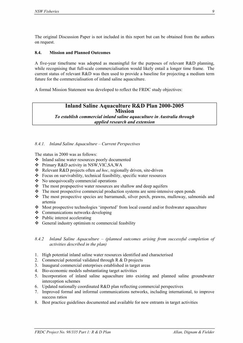
8.4. Mission and Planned Outcomes
A five-year timeframe was adopted as meaningful for the purposes of relevant R&D planning,while recognising that full-scale commercialisation would likely entail a longer time frame. Thecurrent status of relevant R&D was then used to provide a baseline for projecting a medium termfuture for the commercialisation of inland saline aquaculture.
A formal Mission Statement was developed to reflect the FRDC study objectives:
Inland Saline Aquaculture R&D Plan 2000-2005Mission
To establish commercial inland saline aquaculture in Australia throughapplied research and extension
8.4.1. Inland Saline Aquaculture – Current Perspectives
The status in 2000 was as follows: Inland saline water resources poorly documented Primary R&D activity in NSW,VIC,SA,WA Relevant R&D projects often ad hoc, regionally driven, site-driven Focus on survivability, technical feasibility, specific water resources No unequivocally commercial operations The most propspective water resources are shallow and deep aquifers The most prospective commercial production systems are semi-intensive open ponds The most prospective species are barramundi, silver perch, prawns, mulloway, salmonids and
artemia Most prospective technologies ‘imported’ from local coastal and/or freshwater aquaculture Communications networks developing Public interest accelerating General industry optimism re commercial feasbility
8.4.2 Inland Saline Aquaculture – (planned outcomes arising from successful completion ofactivities described in the plan)
1. High potential inland saline water resources identified and characterised2. Commercial potential validated through R & D projects3. Inaugural commercial enterprises established in target areas4. Bio-economic models substantiating target activities5. Incorporation of inland saline aquaculture into existing and planned saline groundwater
interception schemes6. Updated nationally coordinated R&D plan reflecting commercial perspectives7. Improved formal and informal communications networks, including international, to improve
success ratios8. Best practice guidelines documented and available for new entrants in target activities

10 NSW Fisheries
FRDC Project No. 98/335 Part 1: R & D Plan Allan, Dignam & Fielder
9. Industry development phase to generate critical mass for species, regional markets, processingfacilities etc
10. R&D shift from core technologies and pilot commercial projects to productivity improvement,enhancement, value addition, marketing, export, industry extension
11. Skills development12. Public education and promotion
8.4.3. Links with other Priorities and Plans
See Figure 1 for compatability of identified priorities for research and development of inlandsaline aquaculture with other planning documents.
Snapper – one of the candidate species for inland saline aquaculture

NSW Fisheries 11
FRDC Project No. 98/335 Part 1: R & D Plan Allan, Dignam & Fielder
Figure 1: Compatability of identified priorities for research and development of inland salineaquaculture with other planning documents
Plans/Strategies1 Inland saline aquaculture R&D Priorities2
Gro
w-o
ut o
fm
arin
e sp
ecie
sus
ing
shal
low
aqui
fers
Aqu
acul
ture
from
deep
arte
sian
wat
er
Win
ter c
ultu
re o
fsa
lmon
ids u
sing
shal
low
aqu
ifers
Arte
mia
from
exis
ting
faci
litie
s
Hig
h he
alth
praw
n ha
tche
ry
Envi
ronm
enta
lgu
idel
ines
for
inla
nd sa
line
aqua
cultu
re
Res
earc
h an
dex
tens
ion
netw
orki
ng
1. FRDC P P P P P R R
2. Gooley P P R C C R P
3. SCARM P P P P N R R
4. Nat. L&WRA C R R C N R R
5. National ActionPlan for Salinity &Water Quality
P P P P N R R
6. Basin Salinity P P C P N R R
7. NSW Salinity P P N P N P R
8. State Water PlanS.A.
P C N P N R R
9. Salinity ActionPlan W.A.
P C P P N R R
10. ACIAR inlandsaline aquaculture
P P P P P P P
1 Full reference are made to these plans/strategies in Section 8.1 of this report.2 These proposed R & D project areas are outlined in Section 8.5 of this report.
Key:P = PriorityR = Clearly relevantC = May be compatibleN = Not relevant

12 NSW Fisheries
FRDC Project No. 98/335 Part 1: R & D Plan Allan, Dignam & Fielder
1. Investing for Tomorrow’s Fish: the FRDC’s Research and Development Plan, 2000-2005(FRDC, 2001).
FRDC list “increasing production through aquaculture’ as one of the nine challenges for Australiain increasing supply of fish. Growth in aquaculture will require access to suitable sites. FRDC(2001) note that “utilizing saline groundwater may offer significant opportunities for inlandaquaculture of marine species.” The opportunity to use large groundwater interception schemeswith evaporation ponds was also noted (FRDC, 2001).Link with Program & Strategies:Program 2: Industry DevelopmentStrategy: Aquaculture DevelopmentSub-Strategy: Site selection and access for marine and land-based aquaculture.
2. R & D Plan for Integrated Agri-Aquaculture Systems 1999-2004 (Gooley, 2000).
The Mission Statement for this plan is “to develop, promote and coordinate integrated agri-aquaculture system practices within Australian to enhance overall farm productivity and water useefficiency…”. One of the eight ways listed in the Mission Statement to achieve this is by“containing and utilising on-farm otherwise wasted resources such as inland saline and nutrientrich waste waters.”
Inland saline aquaculture is specifically mentioned in two of the five key industry needs listed inthe plan. The first is “the need for relevant background information as an extension resource”(Gooley, 2000). The resource inventory produced as part of this current FRDC project addressesthis need (see Part 2). The second is “the need for more biological and technical informationrelevant to development and implementation of Integrated Agri-Aquaculture Systems inAustralia”. Information on system design and impacts of saline aquaculture are a key componentof this need. Among the strategies listed to address this need is “through appropriate in situindustry trades design and evaluate suitable system design requirements for Integrated Agri-Aquaculture Systems operations on a species by species basis; to include evaluation of fresh andsaline waters, pond, tank and cage-based systems, use of surface and ground waters, mono andpolyculture systems.”
3. Management of Dryland Salinity: Future Strategic Directions. (Standing Committee onAgriculture and Resource Management, [SCARM] 2000).
This document lists aquaculture as one of the ways of “living with salt.” It is recognised as anopportunity for land already salinised (where water tables are less than 2 metres below thesurface). Within the section on “Focus of the National Policy Framework” in the document,significant opportunities to accelerating the development of new industries such as aquaculture arehighlighted. This report includes an appendix (Appendix 2) that gives examples of initiativesundertaken by states to address salinity. Many of these specific initiatives also include referenceto the potential of aquaculture as an opportunity in salt affected areas. Specific plans anddocuments referred to in Appendix 2 include:
Queensland: Salinity Initiatives in Vegetation Management; Salinity Initiatives in Land &Water Management; Salinity Risk Assessment for Potential Irrigation Developments.
Western Australia: Salinity Action Plan 1996, redrafted in 2000 (State Salinity Council ofW.A.).
South Australia: State Dryland Salinity Strategy and Short-Term Action Plan. (The SoilConservation Council of S.A); Mapping of Salinity in S.A. (Primary Industries & ResourcesS.A.). Comprehensive mapping of the State’s agricultural regions for dryland salinity.

NSW Fisheries 13
FRDC Project No. 98/335 Part 1: R & D Plan Allan, Dignam & Fielder
The Upper South East Drainage & Flood Management Plan (Commonwealth, Stategovernments and local land holders).
Catchments Back in Balance. Funded by NHT. Provides Salinity Action Plans to localcommunities and provides support services for successful implementation of the plans.(Highly acclaimed).
Mapping and Monitoring – National Land & Water Resources Audit. A range of projectsthrough NLWRA.
R & D – Using saline resources for new farming systems and industries, PIRSA commissioneda new NHT funded project to examine productive uses for salt affected land – includingaquaculture. This project is called “Using Saline Resources for New Farming Systems andIndustries”, funded to $107,000.
4. National Land and Water Resources Audit – Strategic Plan 1998-2001.
The six objectives of this plan were:i. Providing a clear understanding of the status of, and changes in, the nation’s land,
vegetation and water resources and implications for their sustainable use.ii. Providing an interpretation of the costs and benefits – economic, environmental and social
– of land and water resource change and any remedial actions.iii. Developing a national information system of compatible and readily accessible resource
data.iv. Producing national land, vegetation and water – surface and groundwater – assessments as
integrated components of the Audit.v. Ensuring integration with, and collaboration between, other relevant initiatives.vi. Providing a framework for monitoring Australia’s land and water resources in an ongoing
and structured way.
One of the key challenges identified by the plan was to promote diversity in resource use. Whilenot specifically mentioned, aquaculture in inland saline areas is entirely consistent with thischallenge and with meeting objective ii) above.
5. National Action Plan for Salinity and Water Quality
A National Action Plan for Salinity and Water Quality (called the National Action Plan) wasendorsed by the Prime Minister, Premiers and Chief Ministers at the Council of AustralianGovernments on 3 November 2000. The funding package is $1.4 billion from the Commonwealth,States and Territories over seven years and compliments the existing $1.5 billion National HeritageTrust.
The Action Plan identifies high priority actions to address salinity and deteriorating water qualityto ensure that land and water management practices will sustain productive and profitable land andwater use as well as our natural environments. The Plan reviews the current situation with salinityand lists the following:i. 2.5 million ha (5% cultivated land) currently affected by dryland salinity. This could rise
to 12 million ha.ii. One third of Australian rivers are in extremely poor condition.iii. Land and water degradation, excluding weeds and pests, is estimated to cost up to $3.5
billion/year and affect biodiversity.iv. Infrastructure is being severely damaged in many rural and urban centres.
The National Action Plan builds on the work established under the National Heritage Trust, theMDBC, State and Territory Salinity Strategies at the GAG Water Agreement, particularly throughthe following:

14 NSW Fisheries
FRDC Project No. 98/335 Part 1: R & D Plan Allan, Dignam & Fielder
• targets and standards for national resource management• integrated catchment/regional management plans• capacity building for communities• improved governance framework• clearly articulated roles for the Commonwealth, State/Territory, local government and councils• a public communication program
The potential role for inland saline aquaculture is specifically mentioned under “capacity buildingfor communities in development of production systems attuned to Australian conditions that“….include new commercial opportunities in saline environments (such as brine shrimp and thedevelopment of new salt-tolerant crop and pasture species)…” (AFFA, 2001).
6. Basin Salinity Management Strategy 2001-2015 (Draft) (Murray-Darling BasinCommission [MDBC], 2000).
The draft Basin Salinity Management Strategy takes a 100-year view of the salinity threats to theMurray-Darling Basis (which impacts on the four States – Queensland, NSW, Victoria and SouthAustralia) and the potential benefits of salinity control options (MDBC, 2000). The draft Strategyis supported by salinity strategies or initiatives in each state and works towards the sameobjectives.
The four key objectives of the Strategy can be summarised as follows: to maintain water quality of the Murray-Darling rivers to control the rise in salt loads in all tributary rivers to control land degradation and protect eco-systems, productive land, cultural heritage and
built infrastructure to maximise the benefits for salinity control across the basis (MDBC, 2000)
In the implementation of this Strategy, the completion of salt interception works and the planningand construction of new salt interception works are related to saline aquaculture. Commerciallydriven aquaculture will offset the huge cost of running salt interception schemes and with carefulplanning, greatly reduce the public cost of building new schemes. Using salt as a resource,including the evaluation and validation of saline aquaculture is listed as a priority in theimplementation of the new Strategy.
7. Taking on the Challenge: NSW Salinity Strategy. (Department of Land and WaterConservation [DLWC], 2000).
The NSW Salinity Strategy has been introduced “to slow down the increase in salinity over thenext ten years and lay the foundation for salinity management well into the future” (DLWC, 2000).Six key “goals” to achieve this are listed:
i. protect and manage our native vegetationii. use our land so less water goes into the water tableiii. use water more effectively or efficientlyiv. use engineering solutionsv. make better use of land affected by salt; andvi. focus our efforts on priority salinity hazard landscapes
The engineering solutions include groundwater interception schemes and saline aquaculture islisted as a key salinity-related business opportunity
NSW Fisheries 15
FRDC Project No. 98/335 Part 1: R & D Plan Allan, Dignam & Fielder
8. State Water Plan 2000. South Australia Vol. 1: Policies for a Sustainable Future (SADepartment of Water Resources [SADWR], 2000).
This plan identifies the importance of disposal of saline water collected in salt interceptionschemes by evaporation and notes the potential for more productive uses of these waters, includingaquaculture.
There are a number of other planning documents for South Australia that address salinity. TheDirection for Managing Salinity in South Australia Statement is an umbrella document to morespecific draft state strategies.
9. Salinity Action Plan 1996, updated 2000 (State Salinity Council of WA, 2000).
The WA government released a 30 year Salinity Action Plan in 1996 and redrafted it in 2000. Thebody responsible for this was the State Salinity Council of W.A. Considerable effort in WA hasgone into developing productive systems for salt affected land and results have indicated such landcan be cost-effective. (Initiatives to cultivate aquatic organisms in saline lakes have beendescribed earlier).
The WA Salinity Council also formed a “Salinity R & D Steering Committee” in 1998 to oversee areview of salinity research and development needs for the State and to promote a cross-agencyapproach to seeking funding. Twelve discipline areas were identified for review. These included“aquaculture in inland saline water”.
10. Inland Saline Aquaculture Workshop. Proceedings of a Workshop held 6 & 7 August1997, Perth, W.A.
This workshop was held by ACIAR to examine prospects for aquaculture using inland saline waterand identify constraints. A collection of papers from around Australia highlighting the interest inand progress with various projects to develop inland saline aquaculture were presented. Three keyareas of interest are:• the development of aquaculture as a component of an integrated agricultural production system
that could optimise and maintain the long-term productivity of inland, salt-affected lands andwaters (similar to Geoff Gooley'’ Integrated Agri-Aquaculture System proposal)
• the use of inland saline groundwaters for the culture of marine fish and aquatic products• the possibility of ACIAR-mediated research collaboration with developing countries, several
of which face salinisation of farm land and which share a potential for inland aquaculture.
8.5. The Basis for the Proposed R&D Project Areas
8.5.1. Grow-out of Marine Species Using Shallow Aquifers (e.g. evaporation ponds constructedas part of groundwater interception schemes)
Justification: Australian and world supplies of fish are falling below demand and Australian imports of
seafood products are increasing rapidly. Sea-based and coastal sites are increasingly scarce and expensive Marine species command premium prices Large volumes of apparently suitable water are available Large pond systems (evaporation ponds) or shallow aquifers are available

16 NSW Fisheries
FRDC Project No. 98/335 Part 1: R & D Plan Allan, Dignam & Fielder
The necessity to construct future evaporation ponds as part of new groundwater interceptionschemes offers considerable potential to integrate aquaculture into future salinity controlmeasures.
Suggested Strategies:⇒ Identify resources
• match the extent and nature of resources to species/groups of species. Obtain furtherinformation on saline groundwater resources where this information is lacking.
⇒ Development/validation of production systems.• develop or validate all areas of production including source of seed stock, stocking
strategy (e.g. density), diets and feeding strategies, health management, water qualitymanagement, water supply and effluent disposal.
⇒ Commercialisation and extension strategies.• Identify constraints to commercial development and methods of overcoming these.• Incorporate aquaculture into existing and planned groundwater interception schemes.
Planned outputs (should include):1. Laboratory based bioassays to confirm survival and short-term growth of selected species in
saline groundwater (compared with oceanic seawater)2. Selection of suitable species matched with sites (including existing and planned groundwater
interception schemes)3. Growth and performance data4. Water budget, usage and efficient planning (confirms value of further investigation)5. Bioeconomic model for species/culture systems6. Commercialisation plan, including extension strategy and marketing plan.
Potential areas with previous related activities: Wakool/Tullkool Sub-Surface Drainage Scheme Undera Cooks Plains Griffith Saline lakes in WA
Discussion:Of the 13 highest-ranking commercial ‘prospects’, five (including the top 4) fitted within the broadcategory of ‘Grow-out of marine species using shallow aquifers’.
The nominated species included barramundi, silver perch, prawns, mulloway and snapper. Ofthese, barramundi and prawns are warm temperature species; the remainder are temperate. Ifcommercial production of nominated species from shallow aquifer water were to involve semi-intensive open pond systems – as is probable – there are clear climatic restrictions as to wherethese should be located. There is a separate constraint as to the actual availability of (shallowaquifer) inland saline water of suitable quality and quantity, within such climate zones. There isthe further question as to which of such locations might meet various commercial criteria (such aslocal infrastructure, labour and social amenities).
At this point it is clear that various areas in the Murray Darling basin meet these requirements fortemperate species for much of the year. In addition this is where the vast majority of relevantresearch has been undertaken to date. It is therefore appropriate to build on this knowledge andexperience base.
As to species, production factors currently appear to favour mulloway, and marketing factors tofavour snapper. Silver perch are an appropriate complement in areas with lower salinity. Prawnscould also be grown in temperate areas, although this would limit the growing period. Whichever
NSW Fisheries 17
FRDC Project No. 98/335 Part 1: R & D Plan Allan, Dignam & Fielder
species are adopted for the next phases of research, many of the findings are expected to beapplicable to other species. In Western Australia, black bream have been stocked in shallow salinelakes to enhance recreational angling. Future prospects for commercial “fish-out’ schemes warrantinvestigation.
The pursuit of research projects involving grow-out of barramundi and prawns in warm weatherareas is assisted by the completion of a national assessment of inland saline water resources (Part2). Some preliminary bio-economic modelling needs to be undertaken to determine the case forusing (shallow aquifer) inland saline water rather than extending existing coastal production. It isclear from the existing industry that open pond production of barramundi is increasinglycompromised at higher latitudes. In 1999 the most southerly viable open pond farm is located atTownsville.
The grow-out period for nominated temperate finfish species ranges from 1 to 2 years. Thisimplies a development timeframe of at least 3 to 6 years, based on completion of a successful pilotfollowed by completion of two successive grow-outs on a sub-commercial scale. Use of purpose-designed facilities and application of best practice are strongly indicated to maximise prospects ofa successful outcome.
8.5.2 Aquaculture from Deep Artesian Water
Justification: Australian and world supplies of fish are falling below demand and Australian imports of
seafood products are increasing rapidly. Sea-based and coastal sites are increasingly scarce and expensive. Marine species command premium prices. Low cost/free water may be available at positive pressure; might be put to constructive use. Elevated water temperature may facilitate production of species in out-of-range areas. Disease-free water source. May allow aquaculture where other water sources are lacking, allowing benefits of scale,
regional initiatives etc.
Suggested Strategies:⇒ Identify resources
• match the extent and nature of resources to species/groups of species. Obtain furtherinformation on saline groundwater resources where this information is lacking.
⇒ Development/validation of production systems• develop or validate all areas of production including source of seed stock, stocking
strategy (e.g. density), diets and feeding strategies, health management, water qualitymanagement, water supply and effluent disposal.
⇒ Commercialisation and extension strategies.• Identify constraints to commercial development and methods of overcoming these.
18 NSW Fisheries
FRDC Project No. 98/335 Part 1: R & D Plan Allan, Dignam & Fielder
Planned outputs (should include):1. Laboratory based bioassays to confirm survival and short-term growth of selected species in
saline groundwater (compared with oceanic seawater)2. Water disposal (e.g. through evaporation ponds) plan and water budget.3. Selection of suitable species and culture technologies matched with site (especially for
uncapped bores or effluent from mineral springs). Focus on both pond and tank (includingintensive recirculation systems).
4. Growth and performance data.5. Bioeconomic model for species/culture systems.6. Commercialisation plan, inlcuding extension strategy and marketing plan.
Potential areas: Moree (effluent from mineral springs) Barraclear Gascogne pilot Robe, S.A. NTU
Discussion:It has already been demonstrated that marine species of finfish can be successfully grown inrecirculation and flow-through systems using inland saline water from deep aquifers. In particular:
a small commercial operation in southern NSW uses deep aquifer water and recirculationsystems to produce barramundi, and has operated successfully for many years (albeit at amodest scale);
a second small commercial barramundi operation in Robe SA is also based on deep aquiferwater, and uses a flow-through system; it capitalises on the elevated temperature of theemergent water to produce fish outside their natural climatic zone;
a research project in Gascoyne WA using deep aquifer brackish water and a flow-throughsystem was successful in producing barramundi of market size; there was not howeversufficient water available at any single location to make such a project commercially viable;
Israel boasts a number of ventures utilising brackish deep aquifer water.
Research has not yet addressed the technical or commercial feasibility of applying deep aquiferwater to pond-based systems, although clearly the water itself can prove satisfactory. (Researchprojects in both Australia and the USA have demonstrated the technical feasibility of growingfinfish and/or prawns in ponds using shallow aquifers.)
Deep aquifers extend across much of Australia. Where drilling has located water that is too saltyfor agricultural use the bores have generally been capped. Much of the water from remainingbores has been allowed to run free, resulting in wastage and salination, and also allowing positivepressure heads to fall. A national government-funded program is seeking to restore the situationby capping such wells.
There is also some overlap in the location of deep and shallow aquifers. Water from shallowaquifers may be easier and cheaper to access. However, the quality of deep aquifer water isgenerally more stable through time than is that from shallow aquifers.
Relevant questions relating to deep aquifer aquaculture include:
Are satisfactory water disposal strategies and technologies available? Can the water be accessed, and at what set-up and operating costs? What quantity of water is available as a continuous supply? (For example, would it be
sufficient to support pond-based systems, or only closed systems?)

NSW Fisheries 19
FRDC Project No. 98/335 Part 1: R & D Plan Allan, Dignam & Fielder
Is the quality of the water suitable for fish production, or does it require pre-treatment? Which of the locations are attractive (on other economic and social criteria) as a base for the
establishment of commercial enterprises? Does the site imply net addition of salt at the surface? Do future plans to “cap” free-running deep aquifer bores impact on potential aquaculture?
8.5.3. Winter Culture of Salmonids Using Shallow Aquifers
Justification: Australian and world supplies of fish are falling behind demand Sea-based and coastal sites are increasingly scarce and expensive Current knowledge base suggests salmonids have prospects in VIC and WA using this
approach Opportunity for farm diversification and to offset costs of land remediation
Suggested Strategies:⇒ Review project underway in W.A. and collate growth and performance data (especially with
regard to possible disease and mortality problem associated with elevated temperatures).⇒ Identify constraints to further commercial development and address these where possible.⇒ Identify further R & D priorities if results warrant further involvement.
Planned outputs (should include):1. Bioeconomic model based on results from projects underway in W.A.2. Water effluent and pond sediment control plan developed if results warrant it.3. Commercialisation plan developed.4. Further R & D planned if results encouraging and further research constraints are identified.
Potential areas: Saline lakes in WA and Victoria Shallow aquifer saline water in Victoria
Discussion:Research in Victoria and WA has indicated that salmonids (specifically rainbow trout) will surviveand grow during winter. A number of possible commercial applications are under consideration asa result:
In Victoria, shallow aquifer saline water is available in the irrigation areas, and may offer potentialfor diversification of farm income and to help defray the costs of saline water interventionschemes; rainbow trout are seen as possibly complementary species to silver perch in a partialgrow-out program over winter and summer respectively; a farmer who provided an earlierresearch site is now pursuing a sub-commercial trial on his own initiative;
In WA, shallow aquifer water is similarly available in the wheatfields areas; fish could beharvested for market, possibly collaboratively, or provide the basis for fish-out (subject to the shortgrowing season); WA Fisheries is sponsoring a trial program, “Outback Ocean”, where trout arebeing grown out over this winter in ponds and dams across more than 100 farms; the trout need tobe harvested before the onset of summer temperatures, and hence are stocked at an advanced size(to achieve marketable weight at harvest). Reliance on natural feeding systems reduces effluentproblems but will increase the challenge of achieving satisfactory growth rates.
The WA trial will allow the biological feasibility of this approach to be tested across a widenumber of sites. Successful harvesting of marketable fish from the Outback Ocean will thenprovide some meaningful basis for considering operational issues associated with harvesting,processing and marketing, and also forming some clearer views of likely commerciality.

20 NSW Fisheries
FRDC Project No. 98/335 Part 1: R & D Plan Allan, Dignam & Fielder
Specific issues which attach to winter culture of salmonids include:
costs and risks of supplying advanced fingerling stock to a range of sites; losses from unseasonally hot weather; and the mechanics and economics of end-of-season harvesting, processing and marketing; and rehabilitation of ponds for the next production cycle (including water removal and disposal, if
necessary).
8.5.4. Artemia from Existing Facilities
Justification: Artemia offer greater potential to use existing salinity management infrastructure (evaporation
ponds) than any other candidate species There are immediate markets for cysts, Artemia biomass and derived products for the
aquarium trade and other aquaculture. These markets have been expanded by global shortagesin Artemia, rapidly expanding demand and prices that have tripled over recent years
Artemia grow and reproduce easily in high salinity environments, subject to the availability offood
Expanding knowledge base will facilitate wider use of Artemia in remediation of waste water,including saline water
Artemia culture will become more attractive in association with other forms of agriculture thatmay provide some of the essential nutrients needed for Artemia
Suggested Strategies:⇒ Identify resources
• Review current Artemia production methods and identify potential (and constraints to) forutilizing existing evaporation ponds for commercial Artemia biomass and/or cystproduction. (Particular attention needs to be paid to the scale necessary to beinternationally competitive).
• Identify translocation issues and methods of minimising risks.⇒ Development/validation of production systems.
• develop or validation of methods for production of biomass or cysts (provided earlierreview indicates potential).
⇒ Commercialisation and extension strategies.• Identify potential commercial pointers and initiatives for pilot-scale production project.• Prepare technical and marketing information package and extend these to potential
investors and operators of evaporation schemes.
Potential areas: Cookes Plains, S.A. Pyramid Hill, Victoria Saline lakes in W.A. Evaporation ponds in Murray-Darling Basin.
Discussion:Australia has a substantial investment in saline water intervention schemes, including theassociated evaporation ponds. Much of the discussion on the potential for inland salineaquaculture has centred on the possible use of these ponds directly.
There are some major limitations to the direct use of existing evaporation ponds for mainstreamaquaculture species (finfish, penaeid prawns etc):

NSW Fisheries 21
FRDC Project No. 98/335 Part 1: R & D Plan Allan, Dignam & Fielder
the ponds are designed to concentrate and precipitate out salt, so the water becomessuccessively more concentrated as it moves through the ponds;
their large surface area and shallow depth are not ideal for commercial production orharvesting;
drainage and fallowing of the ponds may adversely affect their performance in their primary(evaporative) role;
if the ponds were stocked, and assuming supplementary feeding, the nutrient load wouldincrease; and
any significant increase would raise issues of water interchange, and also of impact on anydownstream activities (such as salt production).
Artemia, by contrast, may be particularly suited to cultivation in evaporation ponds:
they are euryhaline, but thrive in hypersaline environments; they are generally hardy and easy to grow (availability of sufficient appropriate nutrient at
appropriate cost is likely to be the key limit to production); they are an ideal mechanism for cleaning up residual organic waste, and hence a complement
to adjacent production of conventional species; they are prized as a fishfeed, and can be harvested for live feeding to adjacent finfish; (a
project with these elements is being commercialised in South Australia); and they can be harvested either as cysts or as live biomass, processed as appropriate (e.g. dried
flakes) and marketed locally and overseas.
Countries with commercial Artemia enterprises include the USA (California), the Philippines andVietnam.
Establishment of a commercial Artemia enterprise would involve exploring the above issues,evaluating the available species regarding suitability for particular products and markets, andassessing the availability of suitable sites.
Commissioning of a commercial or sub-commercial operation would likely deliver insights on thepossible incorporation of Artemia into other grow-out projects, and their applicability in thetreatment of industrial wastes generally. A feasibility study would be a logical precedent to anysuch initiative.

22 NSW Fisheries
FRDC Project No. 98/335 Part 1: R & D Plan Allan, Dignam & Fielder
8.5.5. High Health Prawn Hatchery
Justification: The Australian prawn industry needs increased supplies of disease-free, high quality post-
larvae Coastal hatchery sites are scarce and have greater risk of pathogens Inland saline aquaculture offers advantages Significant export potential also exists for disease-free stock Potential extends to other marine species such as finfish, molluscs and other crustaceans.
Suggested Strategies:⇒ Identify resources
• select candidate sites with required quantity and quality of saline water.• select species with most potential (i.e. market demand, proven technology and availability
of broodstock).⇒ Development/validation of production systems
• conduct laboratory-based bioassays using target species to compare inland saline waterfrom identified sites with oceanic water.
• conduct pilot-scale trials to develop and define protocols for broodstock management,spawning, larval rearing and live food production.
• develop protocols to dispose of effluent saline water without returning it to naturalwaterways.
• develop a bioeconomic model.⇒ Commercialisation and extension strategies.
• prepare or adapt hatchery manuals specifically for inland saline hatchery development• prepare investment brief.• disseminate results and extend technology to land managers in suitable areas and potential
investors/hatchery managers.
Planned outputs (should include):1. Identification of suitable sites/species2. Hatchery manual3. Bioeconomic model4. Investment brief5. Commercialisation and extension plan
Discussion:Australian marine aquacultlure is dependent on coastal hatcheries for the supply of grow-out stock.Production of fingerlings and post-larvae in this environment means that they are more easilyexposed to disease through the water itself and from other species. Viral diseases are a particularconcern, and their epidemiology and impact are not well understood. As a result, considerableeffort and expense is invested in systems to minimise the likelihood of infection.
Experience suggests that if grow-out stock can be produced in a disease-free environment, thisprovides them with a head start before encountering any disease load that may exist in their finalenvironment. Anticipated benefits include improved survival, enhanced production and increasedfeed conversion efficiency plus more uniform size distribution at harvest.
In 1989 the US Marine Shrimp Farming Program began developing Specific Pathogen Free (SPF)species for distribution. Prawn farmers in Southeast Asia now import post-larvae as ‘specificpathogen-free’ (SPF) from the Americas, and pay a significant premium for them. Preliminaryresearch indicates that the three northern states of Australia are highly supportive of a similarinitiative, with the intent of testing the benefits of SPF post-larvae in Australia.

NSW Fisheries 23
FRDC Project No. 98/335 Part 1: R & D Plan Allan, Dignam & Fielder
The FRDC Prawn R&D Plan refers to this specific issue of SPF post-larvae, and notes that thehigh health program must be viewed as a one way process.
Inland Australia offers the potential to access disease-free saline water in locations that are free ofother marine species, thereby providing an ideal context for the establishment of SPF hatcheries.Depending on their location, these hatcheries could service adjacent (inland) grow-out operations,coastal grow-out operations and/or export markets.
The establishment and successful operation of such inland hatcheries would also add to overallknowledge and skills in inland saline aquaculture, including the limited use of saline deep aquifers(if these are the preferred source).
It is therefore proposed to pursue the establishment of an inland tiger prawn hatchery in a locationwith access to suitable saline water via an existing bore, and good road access to the coast.However, this will be dependent on the proven commercial reality of closed cycle production forthis species.
The project will address an immediate need of increasing importance for the local prawn industry,and provide insights applicable to other similar production contexts.
Commercial involvement from the outset would be an integral part of the project.
8.5.6. Environmental Guidelines for Inland Saline Aquaculture
Justification: Salinity is a key environmental concern, and any related activities can anticipate intense
scrutiny Water access and disposal will be critical to inland saline aquaculture projects Aquaculture industry has taken an erly policy position re responsible use of saline water (“at
least no worse off”) Responsible aquaculture has the potential to improve the overall utilisation of degraded
resources (land and water) Issues associated with translocating species outside their natural ranges need to be coordinated
(to minimise genetic and health impacts)
Suggested Strategies:⇒ Review existing environmental guidelines and codes of practice for other aquaculture
industries (in Australia and overseas).⇒ Review salinity strategies to ensure proposed aquaculture is consistent with the priorities
contained within these plans.⇒ Review national and state-based translocation policies.⇒ Review general and specific health issues with high priority species.⇒ Draft specific inland saline aquaculture environmental guidelines and codes of practice.⇒ Circulate, edit and codify environmental guidelines and codes of practice.
Planned outputs (should include):1. Review of relevant environmental guidelines and codes of practice for aquaculture.2. Development of specific inland saline aquaculture environmental guidelines and codes of
practice for high priority targe species/culture systems.
Discussion:From an aquaculture perspective, inland saline water is a valuable asset and there is increasinginterest in its responsible use.
24 NSW Fisheries
FRDC Project No. 98/335 Part 1: R & D Plan Allan, Dignam & Fielder
From an environmental perspective, man-made inland saline water is the root cause of the biggestsingle environmental problem facing Australia.
The aquaculture industry is acutely aware of the importance of responsible environmentmanagement to its own sustainability. From the outset it has adopted a strong policy position onthe subject. This is reflected in a paper on ‘Environmental considerations in the use andmanagement of inland saline water bodies for aquaculture’ given at the ACIAR Workshop inAugust 1997:
Two fundamental objectives of aquaculture development are that it be environmentally sustainableand that it be economically viable. Any aquaculture development using saline water must notincrease salinisation and must minimise the release of nutrients to waterways.”
The ACIAR workshop concluded that there was need for a policy framework and guidelines forfuture investigations. Specific points suggested for such a policy included:
that there would be no export of salt from aquaculture to freshwater systems, and that aquaculture would add no extra nutrient load to freshwater systems.
This policy position has been summarised as the no-worse-off position. It does not assume directresponsibility for fixing what has resulted from unwise practices by others. It does commit toavoiding such practices itself. Moreover it does propose that aquaculture has the potential toextract value for the community from what is viewed by many as a waste material rather than anasset.
The development of such guidelines and their proactive use in the design and conduct of R&Dprojects is seen as important in anticipating and addressing the reasonable concerns of others, andin maintaining the momentum towards establishment of commercially viable enterprises based oninland saline aquaculture.
8.5.7. Research and Extension Networking
Justification: Resource constraints together with large number of possible sites and species and culture
systems make coordination necessary to minimise duplication and waste Many potential stakeholders, e.g. land managers wishing to construct groundwater interception
schemes, have little or no knowledge of aquaculture Successive incorporation of knowledge base in new projects will maximise probability of
successful outcomes Investment attraction and market development require communication, education, pre-
marketing to target audiences Geographic spread of relevant projects and emerging information will help build national
momentum for inland saline aquaculture
Suggested Strategies:⇒ Establish a mechanisms to coordinate research and development through a new subprogram or
other formal management process.⇒ Conduct regular workshops targeted at researchers developing technology for inland saline
aquaculture and at land managers faced with dealing with saline groundwater and salinisation.⇒ Review research and extension strategies and direct methods to improve outputs and outcomes.⇒ Develop generic bioeconomic and environmental guidelines and codes of practice.⇒ Promote and publicise inland saline aquaculture.

NSW Fisheries 25
FRDC Project No. 98/335 Part 1: R & D Plan Allan, Dignam & Fielder
⇒ Coordinate links with all other stakeholders including other R & D corporations, landmanagement agencies (e.g. MDBC), state and commonwealth governments departments, landowners affected by rising saline water.
⇒ Periodically revise R & D plan.
Planned outputs (should include):1. Workshops and workshop proceedings2. Guidelines and models3. Promotional material4. Established linkages and communication framework with other stakeholders5. Extension strategies6. Revised R & D plan.
Discussion:Industry consultation would suggest that there is relatively high optimism as to the technicalfeasibility of inland saline aquaculture, and reasonable confidence as to commercial prospects inspecific contexts. There is however also general recognition of the very large number of possiblevariables that could be researched while pursuing that outcome. This is exacerbated by the factthat the States and territories vary significantly in their natural resources, climates and localinterests.
The topic of Inland Saline Aquaculture competes for scarce R&D resources with otheraquaculture, with wild-caught fish, with agriculture, and so on. Given the limited R&D resources,the large number of possible variables and the desire to achieve realistic and meaningfulcommercial outcomes, it was imperative that relevant R&D be coordinated nationally, and that isreflected in the development of this Plan.
The Plan builds on the important groundwork done in the 1997 ACIAR workshop. Synergies alsoemerge from the networking and collaboration of State fisheries staff, industry representatives andfunding bodies on other topics. It is believed, however, that a more deliberate approach toresearch coordination, ongoing networking and information sharing will be necessary for the futureif objectives are to be achieved within a meaningful timeframe.
Some particular concerns include:
reinforcing the focus reflected in the R&D Plan, including proactive distribution of economicand commercial guidelines as available;
efficiently tapping the existing knowledge base in the design and conduct of each successiveR&D project;
logging, tracking and proactively guiding pilot and commercial projects initiated by others, toimprove their prospects of success and also to leverage from them;
successively updating the knowledge base; and being able to respond in an informed and responsible way with information on existing best
practice to any enquirers seeking information on inland saline aquaculture. (This wouldinclude referral to other industries, organisations and individuals where appropriate.)

26 NSW Fisheries
FRDC Project No. 98/335 Part 1: R & D Plan Allan, Dignam & Fielder
Silver perch – another candidate species for inland saline aquaculture inwaters of lower salinity

NSW Fisheries 27
FRDC Project No. 98/335 Part 1: R & D Plan Allan, Dignam & Fielder
9. BENEFITS
The R&D Plan (Part 1) and Resource Inventory and Assessment (Part 2) will assist existing andpotential aquaculturists, R&D funding agencies, research providers, planners and managers involvedwith saline groundwater control and rural communities.
Existing aquaculturists will benefit from having major constraints to commercial development identifiedand brought to the attention of potential research funding agencies and research providers. This shouldimprove funding opportunities to address these constraints. The Project will also benefit this group byfocusing attention on the merit of utilising degraded resources (saline groundwater and saline affectedland) for a commercial business. Aquaculture is one of the few business opportunities with salinegroundwater. This recognition should generate increased government and community support foraquaculture using saline groundwater.
Potential aquaculturists will benefit for reasons given above and also because planners and managersinvolved with saline groundwater control will be aware of opportunities to integrate aquaculture withnew saline groundwater control schemes. This integration could help defray capital and operating costs(for water supply and disposal) for the new aquaculture operation and make obtaining governmentapprovals much easier.
R&D funding agencies and research providers will benefit by having genuine commercial opportunitiesidentified and research issues listed.
Planners and managers involved with saline groundwater control will benefit by having access toinformation on aquaculture opportunities which will help them plan for integration of aquaculture innew saline groundwater control schemes. As these opportunities are realised, and commercial inlandsaline aquaculture develops, the costs of saline groundwater control schemes will be considerablyreduced. Aquaculture ponds are just as effective for evaporation as purpose built evaporation ponds.New control schemes might include high-capacity groundwater pumps (maybe from many bores) andrelatively small evaporation ponds. The operators of the schemes could “sell” saline water toaquaculturists and then “sell” the right for them to dispose of their effluent in the schemes’ evaporationponds.
Rural communities should benefit from the Project as it will speed up commercial development ofcommercial inland saline aquaculture. New business opportunities from this new industry will provideeconomic development and employment.
28 NSW Fisheries
FRDC Project No. 98/335 Part 1: R & D Plan Allan, Dignam & Fielder
10. FURTHER DEVELOPMENTS
The enormous problem with rising saline groundwater is achieving increased national recognition.The National Dryland Salinity Program (NDSP) that was established in 1993, entered a secondphase in 1998/99. The NDSP was established as a means of improving research, development andextension coordination to better manage dryland salinity across Australia. The threat to productiveagriculture from salinity has long been recognised but it is only since the establishment of theNDSP that the extent of the salinity problem has become apparent. In particular, the threat to ruraland even some metropolitan infrastructure (including roads, buildings and properties),environmental resources and access to quality drinking water supplies have recently becomeapparent. Research, development and extension to make better use of degraded land and salinewater is a key objective of the Phase 2 NDSP.
The Dryland Salinity Program has established a new unit called “Options for the Productive Use ofSalinity (OPUS)”. This unit has recognised aquaculture as having potential in saline affectedareas.
At the launch of the Murray-Darling Basin Commission’s 1999 salinity audit, the Federal Ministerfor the Environment described rising salinity as “the worst environmental problem Australiafaces”.
In Dubbo, NSW on 16-17 Mach 2000, the Premier convened a Salinity Summit to addressproblems, causes and opportunities in a coordinated approach. Over two hundred people attendedthis Summit including eight government ministers, twelve Department heads and senior officialsand representatives of community groups across NSW. Aquaculture was identified as having realpotential in saline affected areas. The recommendations from the working group established toidentify ways of encouraging business initiative included the following:
Encourage farmers to diversify into new salinity compatible products, such as aquaculture insaline ponds (4 other products were also listed);
Support research to develop or validate business initiatives in aquaculture research anddevelopment, including the need for demonstration farms and effective extension services, ininland saline affected areas.

NSW Fisheries 29
FRDC Project No. 98/335 Part 1: R & D Plan Allan, Dignam & Fielder
11. CONCLUSION
This project had two planned outcomes. These were the preparation of an R&D Plan for inlandsaline aquaculture (Part 1) and a resource inventory and assessment (Part 2) of inland salineresources for aquaculture.
The R&D Plan developed the following mission statement: “To foster the establishment ofcommercial aquaculture activities in Australia based on the use of inland saline water throughrelevant applied research to remove identified impediments”. The status of inland salineaquaculture in 1999 was described and a vision for 2004 developed to help guide the R&D Plan.
An R&D planning workshop of managers, researchers and industry representatives was convenedto review emerging findings and to agree on priorities for future R&D. The group identified sevenproject areas that would explore specific commercial development opportunities for inland salineaquaculture or address emerging constraints. Preliminary research parameters were thendeveloped for each of these project areas. These project areas were:
1. Grow-out of Marine Species Using Shallow Aquifers.2. Aquaculture from Deep Artesian Water.3. Winter Culture of Salmonids Using Shallow Aquifers.4. Artemia from Existing Facilities.5. High Health Prawn Hatchery.6. Environmental Guidelines for Inland Saline Aquaculture.7. Research and Extension Networking.
The inland saline aquaculture opportunities with the highest potential for commercialdevelopment, which were identified in the R&D Plan were used to help guide the preparation ofthe Resource Inventory and Assessment (Part 2). To prepare the resource inventory, informationwas identified and collated from a wide range of sources, including the Internet, abstracting andsubject-specific databases, agency libraries, unpublished reports, the scientific literature, as well asdiscussions with agency staff. Broad screening criteria were used to avoid collecting detailedinformation and assessing resources that are clearly unsuitable for the establishment of a salineaquaculture industry.
A diverse range of saline water resources was identified as having potential for inland salineaquaculture. These resources included:
1. Existing large-scale groundwater interception schemes and associated disposal basins locatedin three main areas of the southern Murray-Darling Basin. In total, the pond area in existinggroundwater interception schemes and associated disposal basins, identified as havingaquaculture potential, exceeds 6,300 ha in 11 schemes. These schemes were constructed at acost of more than $108 million and cost more than $3 million per year to operate. They areused to dispose of more than 50,000 ML/yr.
2. A number of new proposed and planned saline groundwater interception schemes in thesesame regions. There are another 8 schemes being constructed or planned which could alsohave aquaculture potential. These new schemes will cost more than $50 million to build andmore than $2 million per year to operate. They will dispose of a further more than 13 100ML/yr.
3. Permanent natural saline lakes in Victoria.
30 NSW Fisheries
FRDC Project No. 98/335 Part 1: R & D Plan Allan, Dignam & Fielder
4. Saline and brackish groundwaters from sedimentary basins and fractured rock aquifers aroundAustralia. These were found in all states except Tasmania. A number of brackish geothermalgroundwaters were also identified.
5. Urban groundwater pumping to protect urban infrastructure and property in areas affected bydryland or irrigation-derived salinity. These opportunities for cost-sharing were located in theMurray-Darling Basin and the wheat belt area of southwest Western Australia. There are some74 rural towns (24 in Victoria, 21 in NSW, 1 in South Australia and 28 in Western Australia)which are experiencing or threatened by rising saline groundwater tables.
6. Proposed shallow groundwater pumping in the Ord River Irrigation Area around Kununurra innorthern WA.
7. Two other unusual saline water resources with exceptional aquaculture potential were alsoidentified. These were the proposed Esperance-Kalgoorlie seawater pipeline and salinedrainage water associated with coal mines in NSW and Queensland.
Thirteen criteria were developed for a preliminary assessment of the potential of these identifiedsaline water resources for the establishment of different aquaculture types (eg hatcheries, growoutof euryhaline or stenohaline fish in ponds or recirculation units, etc). These criteria included theavailability of land and freshwater, the nature of the surrounding environment, existinginfrastructure and services and opportunities for cost sharing. The application of the developedcriteria to potentially suitable saline water resources provided an indicative assessment of thesuitability in relation to the various aquaculture types. A number of saline resources wereidentified as being attractive for a range of aquaculture types. (This is based on a preliminary andindicative assessment using tentative scoring criteria, and often with limited resource information.)These were in particular:
The Esperance-Kalgoorlie seawater pipeline. Most groundwater interception schemes. Most of the Kerang Lakes. Urban groundwater pumping. The aquifers of the Murray Hydrogeological Basin. Coal mine drainage water.
NSW Fisheries 31
FRDC Project No. 98/335 Part 1: R & D Plan Allan, Dignam & Fielder
Other titles in this series:
ISSN 1440-3544
No. 1 Andrew, N.L., Graham, K.J., Hodgson, K.E. and Gordon, G.N.G., 1998. Changes after20 years in relative abundance and size composition of commercial fishes caught duringfishery independent surveys on SEF trawl grounds. Final Report to Fisheries Researchand Development Corporation. Project no. 96/139.
No. 2 Virgona, J.L., Deguara, K.L., Sullings, D.J., Halliday, I. and Kelly, K., 1998.Assessment of the stocks of sea mullet in New South Wales and Queensland waters.Final Report to Fisheries Research and Development Corporation. Project no. 94/024.
No. 3 Stewart, J., Ferrell, D.J. and Andrew, N.L., 1998. Ageing Yellowtail (Trachurusnovaezelandiae) and Blue Mackerel (Scomber australasicus) in New South Wales. FinalReport to Fisheries Research and Development Corporation. Project no. 95/151.
No.4 Pethebridge, R., Lugg, A. and Harris, J., 1998. Obstructions to fish passage in NewSouth Wales South Coast streams. Final report to Cooperative Research Centre forFreshwater Ecology.
No. 5 Kennelly, S.J. and Broadhurst, M. K., 1998. Development of by-catch reducing prawn-trawls and fishing practices in NSW's prawn-trawl fisheries (and incorporating anassessment of the effect of increasing mesh size in fish trawl gear). Final Report toFisheries Research and Development Corporation. Project no. 93/180.
No. 6 Allan, G.L., and Rowland, S.J., 1998. Fish meal replacement in aquaculture feeds forsilver perch. Final Report to Fisheries Research and Development Corporation. Projectno. 93/120-03.
No. 7 Allan, G.L., 1998. Fish meal replacement in aquaculture feeds: subprogramadministration. Final Report to Fisheries Research and Development Corporation.Project no. 93/120.
No. 8 Heasman, M.P., O'Connor, W.A., O'Connor, S.J., 1998. Enhancement and farming ofscallops in NSW using hatchery produced seedstock. Final Report to Fisheries Researchand Development Corporation. Project no. 94/083.
No. 9 Nell, J.A., McMahon, G.A., and Hand, R.E., 1998. Tetraploidy induction in Sydney rockoysters. Final report to Cooperative Research Centre for Aquaculture. Project no. D.4.2.
No. 10 Nell, J.A. and Maguire, G.B., 1998. Commercialisation of triploid Sydney rock andPacific oysters. Part 1: Sydney rock oysters. Final Report to Fisheries Research andDevelopment Corporation. Project no. 93/151.
No. 11 Watford, F.A. and Williams, R.J., 1998. Inventory of estuarine vegetation in BotanyBay, with special reference to changes in the distribution of seagrass. Final Report toFishcare Australia. Project no. 97/003741.
No. 12 Andrew, N.L., Worthington D.G., Brett, P.A. and Bentley N., 1998. Interactionsbetween the abalone fishery and sea urchins in New South Wales. Final Report toFisheries Research and Development Corporation. Project no. 93/102.

32 NSW Fisheries
FRDC Project No. 98/335 Part 1: R & D Plan Allan, Dignam & Fielder
No. 13 Jackson, K.L. and Ogburn, D.M., 1999. Review of depuration and its role in shellfishquality assurance. Final Report to Fisheries Research and Development Corporation.Project no. 96/355.
No. 14 Fielder, D.S., Bardsley, W.J. and G.L. Allan. Enhancement of Mulloway (Argyrosomusjaponicus) in intermittently opening lagoons. Final Report to Fisheries Research andDevelopment Corporation. Project no. 95/148.
No. 15 Otway, N.M. and Macbeth, W.G. The physical effects of hauling on seagrass beds.Final Report to Fisheries Research and Development Corporation. Project no. 95/149and 96/286.
No. 16 Gibbs, P., McVea, T. and Louden, B. Utilisation of restored wetlands by fish andinvertebrates. Final Report to Fisheries Research and Development Corporation. Projectno. 95/150.
No. 17 Ogburn, D. and Ruello, N. Waterproof labelling and identification systems suitable forshellfish and other seafood and aquaculture products. Whose oyster is that? FinalReport to Fisheries Research and Development Corporation. Project no. 95/360.
No. 18 Gray, C.A., Pease, B.C., Stringfellow, S.L., Raines, L.P. and Walford, T.R. Samplingestuarine fish species for stock assessment. Includes appendices by D.J. Ferrell, B.C.Pease, T.R. Walford, G.N.G. Gordon, C.A. Gray and G.W. Liggins. Final Report toFisheries Research and Development Corporation. Project no. 94/042.
No. 19 Otway, N.M. and Parker, P.C. The biology, ecology, distribution, abundance andidentification of marine protected areas for the conservation of threatened Grey NurseSharks in south east Australian waters. Final report to Environment Australia.
No. 20 Allan, G.L. Consumer sensory evaluation of silver perch cultured in ponds on meat mealbased diets. Final report to Meat & Livestock Australia. Project no.PRCOP.009.
No. 21 Kennelly, S.J. and Scandol, J.P., 2000. Relative abundances of spanner crabs and thedevelopment of a population model for managing the NSW spanner crab fishery. FinalReport to Fisheries Research and Development Corporation. Project no. 96/135.
No. 22 Williams, R.J., Watford, F.A. and Balashov, V., 2000. Kooragang WetlandRehabilitation Project: History of changes to estuarine wetlands of the lower HunterRiver. Final Report to Kooragang Wetland Rehabilitation Project Steering Committee.
No. 23 Survey Development Working Group, 2000. Development of the National recreationaland Indigenous Fishing Survey. Final Report to Fisheries Research and DevelopmentCorporation. Project no. 98/169. (Volume 1 – main report, Volume 2 – attachments).
No. 24 Rowling, K.R. and Raines, L.P., 2000. Description of the biology and an assessment ofthe fishery of Silver Trevally Pseudocraranx dentex off New South Wales. Final Reportto Fisheries Research and Development Corporation. Project no. 97/125.
No. 25 Allan, G.L., Jantrarotai, W., Rowland, S., Kosuturak, P. and Booth, M., 2000. Replacingfishmeal in aquaculture diets. Final Report to the Australian Centre for InternationalAgricultural Research. Project no. 9207.

NSW Fisheries 33
FRDC Project No. 98/335 Part 1: R & D Plan Allan, Dignam & Fielder
No. 26 Gehrke, P.C., Gilligan, D.M., Barwick, M., 2001. Fish communities and migration inthe Shoalhaven River – Before construction of a fishway. Final report to SydneyCatchment Authority.
No. 27 Rowling, K.R., and Makin, D.L., 2001. Monitoring of the fishery for Gemfish Rexeasolandri, 1996 to 2000. Final report to the Australian Fisheries Management Authority
No. 28 Otway, N.M., 1999. Identification of candidate sites for declaration of aquatic reservesfor the conservation of rocky intertidal communities in the Hawkesbury Shelf andBatemans Shelf Bioregions. Final report to Environment Australia for the MarineProtected Areas Program (Project No. OR22).
No. 29 Heasman, M.P., Goard, L., Diemar, J. and Callinan, R. 2000. Improved Early Survivalof Molluscs: Sydney Rock Oyster (Saccostrea glomerata). Final report to theAquaculture Cooperative Research Centre (Project No. A.2.1.).
No. 30 Allan, G.L., Dignam, A and Fielder, S. 2000. Developing Commercial Inland SalineAquaculture in Australia: Part 1. R&D Plan. Final Report to Fisheries Research andDevelopment Corporation. Project no. 98/335.
No. 31 Allan, G.L., Banens, B. and Fielder, S. 2000. Developing Commercial Inland SalineAquaculture in Australia: Part 2. Resource Inventory and Assessment. Final Report toFisheries Research and Development Corporation. Project no. 98/335.
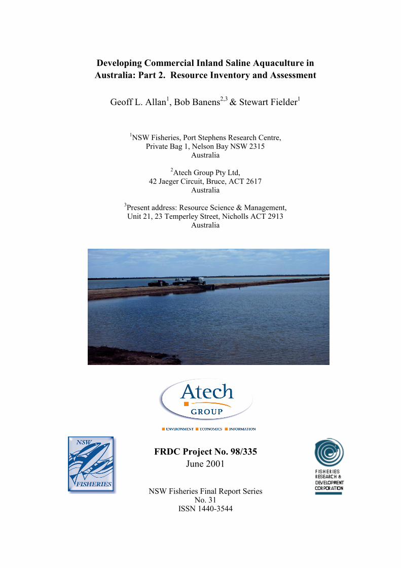
Developing Commercial Inland Saline Aquaculture inAustralia: Part 2. Resource Inventory and Assessment
Geoff L. Allan1, Bob Banens2,3 & Stewart Fielder1
1NSW Fisheries, Port Stephens Research Centre,Private Bag 1, Nelson Bay NSW 2315
Australia
2Atech Group Pty Ltd,42 Jaeger Circuit, Bruce, ACT 2617
Australia
3Present address: Resource Science & Management,Unit 21, 23 Temperley Street, Nicholls ACT 2913
Australia
FRDC Project No. 98/335June 2001
NSW Fisheries Final Report SeriesNo. 31
ISSN 1440-3544

Table of Contents iii
FRDC Project No. 98/335 Allan, Dignam, Banens & Fielder
1. TABLE OF CONTENTS
1. TABLE OF CONTENTS...................................................................................................................... iii
1.1 List of Tables...........................................................................................................................................v1.2.List of Figures ....................................................................................................................................... vi1.3.List of Appendices ............................................................................................................................... vii
2. ACKNOWLEDGMENTS .................................................................................................................. viii
3. NON-TECHNICAL SUMMARY........................................................................................................ ix
4. BACKGROUND .................................................................................................................................... 1
4.1. Inland Saline Aquaculture - Resource and Potential .............................................................................. 14.2.Current Activities in Inland Saline Aquaculture..................................................................................... 2
5. NEED ...................................................................................................................................................... 3
6. OBJECTIVES ........................................................................................................................................ 4
7. METHODS............................................................................................................................................. 5
7.1.Steering Group Formation...................................................................................................................... 57.2.Preparation of the Resource Inventory and Assessment......................................................................... 5
8. INLAND SALINE AQUACULTURE: A RESOURCE INVENTORY AND ASSESSMENT ........ 6
8.1.Executive Summary................................................................................................................................ 68.2.Context ................................................................................................................................................. 118.3.Objectives and Scope of the Project..................................................................................................... 128.4.Approach and Methodology................................................................................................................. 13
8.4.1. Define Criteria for Screening Inland Saline Water Resources ................................................. 138.4.2. Identify and Collate Saline Water Resource Information ......................................................... 148.4.3. Develop Criteria to Assess Suitability of Saline Water Resources for Aquaculture ................. 148.4.4. Assess and Categorise the Suitability of Saline Water Resources ............................................ 158.4.5. Structure of the Rest of the Report ............................................................................................ 15
8.5.Salt Disposal Basins ............................................................................................................................. 168.5.1. Overview ................................................................................................................................... 168.5.2. The MDBC Salinity & Drainage Strategy................................................................................. 168.5.3. Sources of information on salt disposal basins......................................................................... 178.5.4. Issues Relating to Salt Interception Schemes and Disposal Basins .......................................... 188.5.5. Specific disposal basin database search criteria ...................................................................... 208.5.6. Database Search Results........................................................................................................... 208.5.7. The Riverland Region ............................................................................................................... 228.5.8. The Sunraysia Region ............................................................................................................... 228.5.9. The Riverine Plains Region ...................................................................................................... 22
8.6.Salt Interception & Disposal Schemes ................................................................................................. 238.6.1. Woolpunda Groundwater Interception Scheme........................................................................ 238.6.2. Waikerie Salt Interception Scheme ........................................................................................... 238.6.3. Stockyard Plain Disposal Basin................................................................................................ 248.6.4. Noora Drainage Diversion Scheme .......................................................................................... 248.6.5. Rufus River Groundwater Interception Scheme........................................................................ 258.6.6. Mildura-Merbein Groundwater Interception Scheme............................................................... 268.6.7. Buronga Salt Interception Scheme............................................................................................ 27

iv Table of Contents
FRDC Project No. 98/335 Allan, Dignam, Banens & Fielder
8.6.8. Mallee Cliffs Salt Interception Scheme......................................................................................288.6.9. Barr Creek Salinity Control Scheme .........................................................................................288.6.10. Wakool Salinity Control Scheme ...............................................................................................298.6.11. Girgarre Salinity Control Project .............................................................................................308.6.12. Pyramid Hill Groundwater Interception & Salt Harvesting Scheme ........................................30
8.7.Proposed Salt Interception Schemes .....................................................................................................338.7.1. Background ...............................................................................................................................338.7.2. Qualco-Sunlands Groundwater & Salinity Control Scheme .....................................................338.7.3. Waikerie Phase II Salt Interception Scheme .............................................................................348.7.4. Pyramid Creek Groundwater Interception Scheme...................................................................348.7.5. Lindsay River Groundwater Interception Scheme.....................................................................358.7.6. Chowilla Groundwater Interception Scheme ............................................................................358.7.7. Bookpurnong-Loxton Groundwater Interception & Drainage Scheme.....................................368.7.8. North Pike-Murtho Salt Interception Scheme............................................................................378.7.9. Yanda Creek Groundwater Interception Scheme ......................................................................37
8.8.Permanent Victorian Saline Lakes ........................................................................................................388.8.1 Background ...............................................................................................................................388.8.2. The Kerang Lakes System..........................................................................................................388.8.3. Details of Permanent Saline Kerang Lakes...............................................................................398.8.4. The Western District Volcanic Lakes.........................................................................................42
8.9.Saline Groundwater Resources .............................................................................................................448.9.1. Background ...............................................................................................................................448.9.2. Victoria......................................................................................................................................458.9.3. New South Wales .......................................................................................................................478.9.4. South Australia ..........................................................................................................................498.9.5. Western Australia ......................................................................................................................508.9.6. Northern Territory.....................................................................................................................528.9.7. Queensland................................................................................................................................528.9.8. Tasmania ...................................................................................................................................52
8.10. Other Saline Water Resource Opportunities .................................................................................558.10.1. Urban Groundwater Interception Schemes ...............................................................................558.10.2. Small-Scale Shallow Groundwater Opportunities.....................................................................578.10.3. The Ord River Irrigation Area in WA........................................................................................588.10.4. The Proposed Esperance-Kalgoorlie Seawater Pipeline ..........................................................588.10.5. Saline Water in Coal Mines.......................................................................................................59
8.11. Resource Assessment Criteria .......................................................................................................608.11.1. Assessment Categories and Suitability Criteria ........................................................................60
8.12. Saline Resource Assessment .........................................................................................................678.12.1. General......................................................................................................................................678.12.2. Assessing the Suitability of Saline Resources ............................................................................678.12.3. Overview of Assessment Outcomes............................................................................................67
8.13. References and Source Materials ................................................................................................104
9. BENEFITS ..........................................................................................................................................106
10. FURTHER DEVELOPMENTS ........................................................................................................107
11. CONCLUSION ...................................................................................................................................108
12. APPENDICES.....................................................................................................................................110

List of Tables v
FRDC Project No. 98/335 Part 2: Resource Inventory & Assessment Allan, Banens & Fielder
1.1 List of Tables
Table 1: Outline of Salt Interception Schemes and Related Disposal Basins .......................................... 21
Table 2: Summary Information on Existing Salinity Control Schemes (see also Figure 1) ................... 32
Table 3: New Proposed or Planned Groundwater Interception Schemes ............................................... 33
Table 4: Specific Information on Permanent Saline or brackish Kerang Lakes (see Figure 1 forlocations) ........................................................................................................................................................ 42
Table 5: Specific Information on Selected Permanent Saline Western District Lakes (see Figure 1 forlocations) ........................................................................................................................................................ 44
Table 6: Saline and Brackish Groundwater Resources Potentially Suitable for Saline Aquaculture... 53
Table 7: Rural Towns in the Murray-Darling Basin Currently Experiencing or Threatened by RisingSaline Groundwater Tables .......................................................................................................................... 56
Table 8: Rural Towns in Southwest WA Currently Experiencing or Threatened by Rising SalineGroundwater Tables ..................................................................................................................................... 57
Table 9: Assessment Criteria for Various Types of Aquaculture (bracketed numbers indicate relevantassessment tables) .......................................................................................................................................... 64
Table 10: Ranking of Identified Saline Water Resource Interception and or Disposal Schemes forMarine Hatcheries (A) .................................................................................................................................. 69
Table 11: Ranking of Saline Water Resource Interception and Disposal Schemes for Grow-Out ofStenohaline Fish Based on Recirculation (A) .............................................................................................. 74
Table 12: Ranking of Identified Saline Water Resource Interception and or Disposal Schemes forGrow-Out of Stenohaline Fish Using Ponds (A) ......................................................................................... 79
Table 13: Ranking of Identified Saline Water Resource Interception and or Disposal Schemes forGrow-Out of Diadromous Fish Using Recirculation (A)............................................................................ 84
Table 14: Ranking of Identified Saline Water Resource Interception and or Disposal Schemes forGrow-Out of Diadromous Fish Using Ponds (A) ........................................................................................ 89
Table 15: Ranking of Identified Saline Water Resource Interception and or Disposal Schemes forNative Fish Based on Recirculation (A)....................................................................................................... 94
Table 16: Ranking of Identified Saline Water Resource Interception and or Disposal Schemes forNative Fish Based Ponds (A) ........................................................................................................................ 99

vi List of Figures
FRDC Project No. 98/335 Part 2: Resource Inventory & Assessment Allan, Banens & Fielder
1.2. List of Figures
Figure 1: Locations of existing and proposed salt water disposal basins and salt lakes in southeastAustralia............................................................................................................................................................8
Figure 2: Locations of the major basins with the greatest potential for inland saline aquaculture.........9
Figure 3: Urban salinity in the Murray Darling Basin..............................................................................10

List of Appendices vii
FRDC Project No. 98/335 Part 2: Resource Inventory & Assessment Allan, Banens & Fielder
1.3. List of Appendices
Appendix 1: Ambient Air Temperatures in Representative Irrigation Areas....................................... 111
Appendix 2: Representative Water Chemistry of Selected Salt Interception Schemes ........................ 112
Appendix 3: Representative Water Chemistry of Permanent Saline Lakes and GroundwaterResources...................................................................................................................................................... 113

viii Acknowledgments
FRDC Project No. 98/335 Part 2: Resource Inventory & Assessment Allan, Banens & Fielder
2. ACKNOWLEDGMENTS
We thank the Fisheries Research and Development Corporation (FRDC) for funding this projectand Dr Patrick Hone (FRDC) for his help with managing the project. Dr Chris Barlow(Queensland Department of Primary Industries [QDPI]), originally submitted the projectapplication but decided not to proceed with the project after priorities for Queensland aquaculturewere reviewed. The application was revised and submitted by NSW Fisheries. We thank DrBarlow for his vision of aquaculture in inland saline waters in Australia and for his helpthroughout the project. We also thank Mr Barney Smith (Australian Centre for InternationalAgricultural Research [ACIAR]) who convened the 1997 ACIAR Workshop on Inland SalineAquaculture. The need for the current project was originally identified at the ACIAR Workshop.
Ms Helena Heasman (NSW Fisheries) cheerfully completed the mammoth task of report collationand preparation.
We thank the following people from Atech Group for their help with the Resource Inventory andAssessment component of this report: Ms Ashley Fuller, Dr Barry Macaulay, Dr Laslo Nagy andDr Ron Rosich. We would also like to thank the following people who provided information toAtech Group which was used in the Resource Inventory and Assessment component of this report:Pradeep Sharma and Bob Newman (Murray-Darling Basin Commission); Ray Evans (Bureau ofResource Sciences, formerly AGSO); Peter Forward (SA Water); Mike Ernie and Mike Williams(NSW Department of Land and Water Conservation); John Ginnivan and Peter Dickinson(Goulburn-Murray Water); Keith Collett, Rob O’Brien and Danielle Heffer (Victorian Departmentof Natural Resources & Environment); Carl Mathers (Murray Irrigation Ltd.); Gavin Privett(Pyramid Salt Pty Ltd.); Matt Kendall and Sally Jeremiah (Sinclair Knight Merz).
DisclaimerEvery attempt has been made to provide accurate information in this document. However, noliability attaches to NSW Fisheries, Atech Group Pty Ltd or to any other organisation or individualconcerned with the supply of information or the preparation of this document for anyconsequences of using the information contained in the document.

Non-Technical Summary ix
FRDC Project No. 98/335 Part 2: Resource Inventory & Assessment Allan, Banens & Fielder
3. NON-TECHNICAL SUMMARY
98/335 Developing Commercial Inland Saline Aquaculture in Australia.Part 2. Resource Inventory and Assessment
PRINCIPAL INVESTIGATORS: Dr Geoff Allan
ADDRESS: NSW FisheriesPort Stephens Research CentrePrivate Bag 1Nelson Bay NSW 2315Tel: 02 4982 1232 Fax: 02 4982 1107
OBJECTIVES:
1. Review the developmental status of inland saline aquaculture in Australia.
2. Evaluate likely obstacles and limitations to the commercial expansion of inland salineaquaculture and the ability for R & D to address these limitations.
3. Develop an R & D plan to address these obstacles and limitations in consultation with theaquaculture industry and related disciplinary experts (Developing Commercial Inland SalineAquaculture in Australia: Part 1. R & D Plan).
4. Document the distribution and characteristics of inland saline groundwaters and their potentialuse for the farming of aquatic organisms (Developing Commercial Inland Saline Aquaculturein Australia. Part 2. Resource Inventory and Assessment).
NON TECHNICAL SUMMARY:
The National R&D Plan for Inland Saline Aquaculture arose following a workshop on inlandsaline aquaculture run by ACIAR. Two of the main outcomes of the Workshop were identificationof the need for a national, strategic R&D Plan for inland saline aquaculture (Part 1) andidentification of the need for an inventory of inland saline resources and assessment of thepotential of these for aquaculture (Part 2).
Existing Inland Saline Aquaculture in Australia
There are small-scale research and development or commercial inland saline aquaculture projectsin all states except Queensland, Tasmania and the ACT. Current activities include:
NSW - NSW Fisheries investigating snapper culture, with funding from the CRC forAquaculture; one commercial barramundi farm; CSIRO (L & W) Project on serial biologicalconcentration to combine irrigation and saline aquaculture.
Victoria - Inland Mariculture Scoping Study was undertaken on a range of sub-tropical andtemperate species; funding from the State Government and Murray-Darling BasinCommission. Rural Industries Research & Development Corporation (RIRDC), ACIAR, andthe State Government are funding other smaller-scale saline water studies with silver perchand rainbow trout. One commercial operation producing Artemia (brine shrimp) and salt.

x Non-Technical Summary
FRDC Project No. 98/335 Allan, Dignam, Banens & Fielder
SA - investigating production of Artemia, Dunaliella and finfish in poly-tunnels as part of salt-water management procedures; RIRDC funding. Commercial farms for barramundi and otherfinfish being developed.
WA - extensive interest in inland saline aquaculture - Outback Ocean project by WA Fisheriesto trial black bream and winter trout production in saline ponds and dams. A detailed resourceinventory is also being compiled.
NT - has undertaken successful pilot-scale Dunaliella (micro-algae) production near AliceSprings; commercial venture currently being established. Experimental production of the tigerprawn Penaeus monodon using saline bore water is underway at the University of NT.
Qld - presently no inland saline aquaculture. Tas – presently no inland saline aquaculture.
Resource Inventory and Assessment
The contract to help prepare the Resource Inventory and Assessment was won by the consultantsAtech Pty Ltd on the basis of price and documented experience preparing similar inventories andwith accessing and cataloguing hydrological data from government agencies throughout Australia.The objectives of the inventory project were:
1. To undertake an inventory of key saline surface and groundwater resources that may besuitable for inland saline aquaculture.
2. To undertake a preliminary assessment of the suitability of identified resources for theestablishment of hatchery or adult fish production aquaculture.
Information was identified and collated from a wide range of sources, including the Internet,abstracting and subject-specific databases, agency libraries, unpublished reports, the scientificliterature, as well as discussions with agency staff. Broad screening criteria were used to avoidcollecting detailed information and assessing resources that are clearly unsuitable for theestablishment of a saline aquaculture industry.
A diverse range of saline water resources was identified as having potential for inland salineaquaculture. These resources included:
1. Existing large-scale groundwater interception schemes and associated disposal basins locatedin three main areas of the southern Murray-Darling Basin. These were:
the Riverland Region of SA; the Sunraysia Region of Victoria and NSW; and the Riverine Plains west of Shepparton in northern Victoria.
In total, the pond area in existing groundwater interception schemes and associated disposalbasins, identified as having aquaculture potential, exceeds 6 250 ha in 11 schemes. Theseschemes were constructed at a total cost of more than $108 million and cost more than $3million per year to operate. They are used to dispose of more than 50 000 ML/yr.
2. A number of new proposed and planned saline groundwater interception schemes in thesesame regions.
There are another 8 schemes being constructed or planned which could also have aquaculturepotential. These new schemes will cost more than $50 million to build and more than $2million per year to operate. They will dispose of a further more than 13 100 ML/yr.

Non-Technical Summary xi
FRDC Project No. 98/335 Part 2: Resource Inventory & Assessment Allan, Banens & Fielder
3. Permanent natural saline lakes in Victoria, these were:
the Kerang Lakes on the Riverine Plains near Kerang; and the Western District Volcanic Lakes near Colac.
4. Saline and brackish groundwaters from sedimentary basins and fractured rock aquifers aroundAustralia. These were found in all states except Tasmania. A number of brackish geothermalgroundwaters were also identified.
5. Urban groundwater pumping to protect urban infrastructure and property in areas affected bydryland or irrigation-derived salinity. These opportunities for cost-sharing were located in:
the Murray-Darling Basin; and the wheat belt area of southwest Western Australia.
ome 74 rural towns (24 in Victoria, 21 in NSW, 1 in South Australia and 28 in Western Australia)which are experiencing or threatened by rising saline groundwater tables.
6. Proposed shallow groundwater pumping in the Ord River Irrigation Area around Kununurra innorthern WA.
7. Two other unusual saline water resources with exceptional aquaculture potential were alsoidentified. These were:
The proposed Esperance-Kalgoorlie seawater pipeline. Saline drainage water associated with coal mines in NSW and Queensland.
Thirteen criteria were developed for a preliminary assessment of the potential of these identifiedsaline water resources for the establishment of hatchery or adult fish production aquaculture.These criteria dealt with the following areas:
The availability and nature of the resource. The availability of land and freshwater. The nature of the surrounding environment. Existing infrastructure and services. Opportunities for cost-sharing.
Specific criteria and tentative weightings were developed which addressed different salineaquaculture requirements of different industry types. The aquaculture types used were:
marine hatcheries; grow-out of stenohaline fish using recirculating facilities; grow-out of stenohaline fish using ponds; grow-out of diadromous fish using recirculating facilities; grow-out of diadromous fish using ponds; grow-out of freshwater native fish using recirculating facilities; and grow-out of freshwater native fish using ponds.
The application of the developed criteria to potentially suitable saline water resources provided anindicative assessment of the suitability in relation to the various aquaculture types.
A number of saline resources were identified as being attractive for a range of aquaculture types.(On the basis of a preliminary and indicative assessment using tentative scoring criteria, and oftenwith limited resource information.) These were in particular:

xii Non-Technical Summary
FRDC Project No. 98/335 Allan, Dignam, Banens & Fielder
The Esperance-Kalgoorlie seawater pipeline. Most groundwater interception schemes. Most of the Kerang Lakes. Urban groundwater pumping. The aquifers of the Murray Hydrogeological Basin. Coal mine drainage water.

NSW Fisheries 1
FRDC Project No. 98/335 Part 2: Resource Inventory & Assessment Allan, Banens & Fielder
4. BACKGROUND
This project arose from a national workshop on Inland Saline Aquaculture held in Perth on 6-7August 1997. The Workshop was funded primarily by ACIAR, with co-funding support providedby FRDC and RIRDC. It was convened because of the high level of interest in inland salineaquaculture in Australia, and the need to coordinate R&D activities from a national perspective.The Workshop brought together selected aquaculture and land/water specialists from AustralianStates and Territories, along with representatives from ACIAR, FRDC and the CRC forAquaculture. Workshop sessions addressed current activities in the country, key technical andenvironmental issues, and major opportunities and constraints to the development of inland salineaquaculture ventures. A comprehensive report of the proceedings and outcomes was published byACIAR in 1999.
The main outcome of the Workshop was identification of the need for development of a strategicplan to provide a national framework for R&D on inland saline aquaculture. The plan was neededto help guide and facilitate the integration of R&D across geographical areas, land/waterdisciplines, taxa, industry sectors and potential investment groups and between funding, researchand management agencies. In addition, the need for an inventory of inland saline groundwaterresources and an assessment of their aquaculture potential was also recognised.
4.1. Inland Saline Aquaculture - Resource and Potential
Farming of marine species in Australia's coastal zone is increasingly limited by high land prices,shortage of suitable sites, environmental constraints (land and water alienation and effluentdisposal) and conflict with other land and water users. As highlighted in the National Strategy onAquaculture (1994) it is clear that a shortage of suitable coastal sites is a major constraint to theexpansion of the mariculture industry in Australia.
Away from the coastal zone, Australia has large inland saline water resources. These waterresources can be grouped into the following categories:
1. Natural saline lakes: common in south-eastern Australia, can be large in area and highlyseasonal.
2. Shallow aquifers and salt affected farm land: saline water tables at or near the surface, oftencaused by changes in land management practices that have altered natural water tables.
3. Deep aquifers: generally at depths greater than 30 metres, formed from ancient water;chemically stable; can be artesian (some suitable, others not).
The availability of inland saline waters opens up the potential for development of a salineaquaculture industry remote from the sea. Commercial incentives that would encourage thedevelopment of inland mariculture include comparatively cheap land, enhanced quarantinecapability and limited conflict over the same resource. The opportunity for integrating theseactivities with land salinisation remedial operations is particularly attractive. Such developmentwould provide an additional incentive for a systems approach to remediation projects, help offsetcosts of such projects and provide important additional benefits of job creation and diversificationfor the farming industry in remote rural areas.
2 NSW Fisheries
FRDC Project No. 98/335 Part 2: Resource Inventory & Assessment Allan, Banens & Fielder
4.2. Current Activities in Inland Saline Aquaculture
Research activities in inland saline aquaculture are comparatively recent, but are being undertakenin several States.
NSW - NSW Fisheries investigating snapper culture, with funding from the CRC forAquaculture; one commercial barramundi farm; CSIRO (L & W) Project on serial biologicalconcentration to combine irrigation and saline aquaculture.
Victoria - Inland Mariculture Scoping Study was undertaken on a range of sub-tropical andtemperate species; funding from the State Government and Murray-Darling BasinCommission. RIRDC, ACIAR, and the State Government are funding other smaller-scalesaline water studies with silver perch and rainbow trout. One commercial operation producingArtemia and salt.
SA - investigating production of Artemia, Dunaliella and finfish in poly-tunnels as part of salt-water management procedures; RIRDC funding. Commercial farms for barramundi and otherfinfish being developed.
WA - extensive interest in inland saline aquaculture, “Outback Ocean” project by WAFisheries to trial winter salmon production in saline ponds and dams.
NT - has undertaken successful pilot-scale Dunaliella production near Alice Springs;commercial venture currently being established. Experimental production of P.monodon usingsaline bore water is underway at the University of NT.
Qld - presently no inland saline aquaculture. Tas – presently no inland saline aquaculture.

NSW Fisheries 3
FRDC Project No. 98/335 Part 2: Resource Inventory & Assessment Allan, Banens & Fielder
5. NEED
There is considerable interest in the potential for inland saline aquaculture in Australia. Severaldevelopmental projects are currently underway. While these are appropriate regionally, they arebeing undertaken in the absence of planning and review at the national level. There is an urgentneed for national planning to ensure that current and future R&D is coordinated, focused, avoidsduplication, and is targeted at realistic and meaningful commercial outcomes. The mapping andclassification of inland saline groundwater resources will provide a valuable information bank forboth researchers and investors. Successful development of inland saline aquaculture will generateemployment opportunities in rural areas, and may defray costs associated with management ofshallow saline aquifers.
ATTRACTIVENESS:The development of a national plan for coordinating R&D on inland saline will have benefits forall stakeholders. The industry will benefit from streamlined research aimed at commercialoutcomes. Funding agencies and research providers will have guidelines indicating priorities, anda plan for where particular projects fit into the bigger scheme of R&D in inland saline aquaculture.
FEASIBILITY:The recent workshop on Inland Saline Aquaculture in Perth has laid much of the groundwork forthe present project. The Aquaculture Committee, on which all State fisheries managementagencies are represented, committed its support for the project. There are no technical constraintsto satisfactory completion of the project.
RISKS:The major risk is that a consultant sufficiently knowledgeable and experienced to prepare the R&Dplan is not available for the consultancy. However, the steering group for the project will activelysolicit appropriate people if necessary.

4 NSW Fisheries
FRDC Project No. 98/335 Part 2: Resource Inventory & Assessment Allan, Banens & Fielder
6. OBJECTIVES
1. Review the developmental status of inland saline aquaculture in Australia.
2. Evaluate likely obstacles and limitations to the commercial expansion of inland salineaquaculture and the ability for R&D to address these limitations.
3. Develop an R&D plan to address these obstacles and limitations in consultation with theaquaculture industry and related disciplinary experts (Part 1).
4. Document the distribution and characteristics of inland saline groundwaters and their potentialuse for the farming of aquatic organisms (Part 2).

NSW Fisheries 5
FRDC Project No. 98/335 Part 2: Resource Inventory & Assessment Allan, Banens & Fielder
7. METHODS
7.1. Steering Group Formation
A small interdisciplinary steering group (representatives from industry [such as NAC andother relevant groups], research and management) was formed to provide expert input into thedevelopment of the R&D Plan (Part 1). Members of the Steering Committee met with theConsultant appointed to help prepare the R&D Plan individually and then collectively in aworkshop to review and prioritise R&D activities.
The type of inland saline water resources identified by the Steering Committee to have thehighest priority for commercial aquaculture developments were identified. These were thennominated as key types of resources to help focus the Resource Inventory and Assessmentcomponent of the project (Part 2).
7.2. Preparation of the Resource Inventory and Assessment
A decision was made not to employ someone directly to undertake this aspect of the project (aswas originally proposed) but to contract out the task to a consultant. This decision was takenbecause of the importance of knowing where the relevant information was located and the obviousexperience some of the consultants had with this compiling similar types of inventories. A second“Expression of Interest” was drafted and sent to all respondents from the first advertisement.There were four excellent applications. The successful applicant, Atech Group, was selected onthe basis of price and demonstrated experience with water resource inventories.
6 NSW Fisheries
FRDC Project No. 98/335 Part 2: Resource Inventory & Assessment Allan, Banens & Fielder
8. INLAND SALINE AQUACULTURE: A RESOURCE
INVENTORY AND ASSESSMENT
8.1. Executive Summary
The objectives of this inventory project were:
1. To undertake an inventory of key saline surface and groundwater resources that may besuitable for inland saline aquaculture.
2. To undertake a preliminary assessment of the suitability of identified resources for theestablishment of hatchery or adult fish production aquaculture.
Information was identified and collated from a wide range of sources, including the Internet,abstracting and subject-specific databases, agency libraries, unpublished reports, the scientificliterature, as well as discussions with agency staff. Broad screening criteria were used to avoidcollecting detailed information and assessing resources that are clearly unsuitable for theestablishment of a saline aquaculture industry.
A diverse range of saline water resources was identified as having potential for inland salineaquaculture. These resources included:
Existing large-scale groundwater interception schemes and associated disposal basins locatedin three main areas of the southern Murray-Darling Basin (see Figure 1). These were:- the Riverland Region of SA;- the Sunraysia Region of Victoria and NSW; and- the Riverine Plains west of Shepparton in northern Victoria.
A number of new proposed and planned saline groundwater interception schemes in thesesame regions.
Permanent natural saline lakes in Victoria, specifically:- the Kerang Lakes on the Riverine Plains near Kerang; and- the Western District Volcanic Lakes near Colac.
Saline and brackish groundwaters from sedimentary basins and fractured rock aquifers aroundAustralia. These were found in all states except Tasmania (see Figure 2). A number ofbrackish geothermal groundwaters were also identified.
Urban groundwater pumping to protect urban infrastructure and property in areas affected bydryland or irrigation-derived salinity (see Figure 3). These opportunities for cost-sharing werelocated in:- the Murray-Darling Basin; and- the wheat belt area of southwest Western Australia.
Proposed shallow groundwater pumping in the Ord River Irrigation Area around Kununurra innorthern WA.
Two other unusual saline water resources with exceptional aquaculture potential were alsoidentified. These were:
The proposed Esperance-Kalgoorlie seawater pipeline. Saline drainage water associated with coal mines in NSW and Queensland.

NSW Fisheries 7
FRDC Project No. 98/335 Part 2: Resource Inventory & Assessment Allan, Banens & Fielder
Thirteen criteria were developed for a preliminary assessment of the potential of these identifiedsaline water resources for the establishment of hatchery or adult fish production aquaculture.These criteria dealt with the following areas:
The availability and nature of the resource. The availability of land and freshwater. The nature of the surrounding environment. Existing infrastructure and services. Opportunities for cost-sharing.
Specific criteria and tentative weightings were developed which addressed different salineaquaculture requirements of different industry types (see Table 9.9). The aquaculture types usedwere:
marine hatcheries; grow-out of stenohaline fish using recirculating facilities; grow-out of stenohaline fish using ponds; grow-out of diadromous fish using recirculating facilities; grow-out of diadromous fish using ponds; grow-out of freshwater native fish using recirculating facilities; and grow-out of freshwater native fish using ponds.
The application of the developed criteria to potentially suitable saline water resources provided anindicative assessment of the suitability in relation to the various aquaculture types.A number of saline resources were identified as being attractive for a range of aquaculture types.These were in particular:
The Esperance-Kalgoorlie seawater pipeline. Most groundwater interception schemes. Most of the Kerang Lakes. Urban groundwater pumping. The aquifers of the Murray Hydrogeological Basin. Coal mine drainage water.
The results are, however, a preliminary and indicative assessment using tentative scoring criteria,and often with limited resource information. Other potential saline water resources, such as theWestern District Volcanic Lakes, could well score better under different criteria or weightings, orhave other qualities that may make them more attractive to the establishment of saline aquaculture.

FRDC Project No. 98/335 Part 2: Resource Inventory & Assessment Page 8
Figure 1: Locations of existing and proposed salt water disposal basins and salt lakes in southeast Australia

NSW Fisheries 9
FRDC Project No. 98/335 Part 2: Resource Inventory & Assessment Allan, Banens & Fielder
Figure 2: Locations of the major basins with the greatest potential for inland saline aquaculture

10 NSW Fisheries
FRDC Project No. 98/335 Part 2: Resource Inventory & Assessment Allan, Dignam, Banens & Fielder
Figure 3: Urban salinity in the Murray Darling Basin
NSW Fisheries 11
FRDC Project No. 98/335 Part 2: Resource Inventory & Assessment Allan, Dignam, Banens & Fielder
8.2. Context
Inland saline aquaculture has the potential to become an important emerging industry for Australia,and a number of research, scoping and pilot studies, based on finfish, crustaceans and algae, arealready being undertaken in a number of states. This high level of interest was reflected at anational workshop on the subject in Perth in 1997, which explored the opportunities andconstraints facing the development of inland saline aquaculture in Australia (Smith and Barlow1999). The workshop identified as one of its priorities, the need for the development of a strategicplan to coordinate and provide a national framework for research and development on inland salineaquaculture. Another important identified issue was the development of an inventory of inlandsaline water resources for potential use by aquaculturists.
NSW Fisheries at the Port Stephens Research Centre has received funding from FRDC, to supportthe development of an inland saline aquaculture industry. One of the key activities was toundertake an inventory and resource assessment of suitable inland saline water resources foraquaculture. These resources of interest are broadly of three principal types:
1. Saline water resources in irrigation areas, particularly where drainage water or groundwater isdisposed of into evaporation basins - particularly in the Murray-Darling Basin, andsoutheastern Western Australia.
2. Other saline groundwaters.3. Saline water in permanent or ephemeral lakes.
The development of a saline resource inventory would include general information on the location,size, ownership and surrounding infrastructure, so as to enable a general assessment of suitabilityof the resource for the establishment of an aquaculture industry. It would also include morespecific information on the water quality characteristics of the resource to enable a generalassessment of its potential suitability for saline aquaculture.More specifically the inventory was to include the following information where this is available:
1. location and type of saline water;2. ownership;3. contact details;4. brief description of the scheme or water system;5. water supply volume and seasonal changes or flows;6. estimation of availability of adjacent land for aquaculture;7. nearby infrastructure;8. opportunity for waste-water disposal;9. water quality (salinity range; ionic composition, pH, nutrients etc.); and10. ambient air temperatures.

12 NSW Fisheries
FRDC Project No. 98/335 Part 2: Resource Inventory & Assessment Allan, Dignam, Banens & Fielder
8.3. Objectives and Scope of the Project
The specific objectives of the project are:
1. To undertake an inventory of key saline surface and groundwater resources on the Australianmainland that are potentially suitable for saline aquaculture.
2. To undertake an assessment of the suitability of identified saline resources, their location andsurrounding infrastructure for the establishment of various types of aquaculture industries.This may be hatcheries or adult fish production.
The following points have been agreed upon to assist in defining the scope and limitations of theproject:
The primary focus of the study will be on evaporation or disposal basins associated withgroundwater pumping schemes in the irrigation areas, particularly those in the Murray-DarlingBasin, and where they exist in southeastern Western Australia. This follows identification ofthese areas in the national R&D plan as having the highest potential for aquaculture.
The project will also examine other significant saline groundwater resources in shalloweraquifers, especially from the prospective use of these resources for marine hatcheries.
The project will also evaluate the resource potential of significant permanent saline lakes.Opportunities are more limited for use of ephemeral saline resources. It is noted neverthelessthat an assessment of the aquaculture resource potential of ephemeral Western Australian lakesis currently being undertaken.
Estuarine lakes will not be considered in this inventory It was agreed that the emphasis of the study would be on New South Wales, Victoria, South
Australia, southeast Queensland, particularly in the Murray-Darling Basin, and the southwestof Western Australia. Given the limited resources it was decided that the Northern Territoryand Tasmania would not be included in this scoping review.
The waters of interest to saline aquaculture range from virtual freshwater to seawater andbeyond. The wide salinity range reflects the fact that many marine and freshwater fish can beacclimatized to brackish water. Practically this study has largely limited itself to considerationof waters in the range of 3,000 to 75,000 mg/L of salt.
Dual fresh and saline water supplies are of particular interest to saline aquaculture, because ofthe potential for blending of water to achieve or maintain salinities as well as other productionaspects.
The ionic composition of water resources can be important in regard to saline aquaculture andshould be characterised where possible. Deficiencies in composition in comparison withseawater should not however, preclude consideration of their potential use for aquaculture, asthese may be able to be overcome by inexpensive remediation.
The size of evaporation basins or ponds for potential use in aquaculture is variable, and canrange from several tens to hundreds of hectares. Similarly the minimum volume of waterresource required varies depending on the nature of the aquaculture industry, but has beentaken as 50,000 L/day (~18 ML/yr).
The potential capacity to dispose of saline wastewater from aquaculture - which can be in theorder of 10% of total water use per day – has to be considered as an important issue.
The broad focus of this study is saline aquaculture associated with hatcheries, finfish,crustaceans and shellfish production – it will not deal with issues associated with saline algalaquaculture.
There are different resource and infrastructure requirements for hatcheries, intensiverecirculation grow-out facilities and intensive grow-out ponds for stenohaline, diadromous andfreshwater fish. Details of the requirements for these various types of aquaculture have beendeveloped in consultation with Geoff Allan and Stuart Fielder from NSW Fisheries.
NSW Fisheries 13
FRDC Project No. 98/335 Part 2: Resource Inventory & Assessment Allan, Banens & Fielder
8.4. Approach and Methodology
The following approach was adopted for this study:
1. Define criteria for an initial screening of inland saline water resources.2. Identify potentially suitable saline water resources.3. Collate information on identified saline water resources.4. Develop criteria to assess the suitability of inland saline water resources for various types of
aquaculture.5. Assess and categorise the suitability of inland saline water resources for various types of
aquaculture.
Each of these steps is briefly elaborated below.
8.4.1. Define Criteria for Screening Inland Saline Water Resources
This is the initial screening process for selecting inland saline water resources or areas for moredetailed assessment for potential aquaculture use. An initial set of screening criteria required forthis task, was broadly defined at the first project meeting. However, it was soon recognized that inmany cases at a broad national scale it would not be possible to apply quantitative criteria.Consequently, some subjective and qualitative criteria - based nevertheless on common sense –were developed and used. The application of these criteria – as indicated below – was to helpfocus on saline water resources that had most potential for the establishment of an aquacultureindustry. The nature of the screening criteria used were:
Broad geographic regions or areas of interest.- Southeast Australia.- The Murray-Darling Basin.- Southwest Western Australia.- Other locations around Australia on an ad hoc basis.
Saline water resources of interest.- Evaporation basins and saline groundwater disposal schemes (including potential schemes)
in the Murray-Darling Basin and southeast WA.- Saline water from shallow and deep aquifers.- Saline water in permanent saline lakes in Victoria.- Other potential saline water resources.
Magnitude and reliability of the saline water resource - volume, area or flow.- Groundwater or drainage water disposal basins - a minimum pumped volume of ~50 x 103
L/day (~18 ML/yr) or a minimum volume of 2 ML. Continuity of supply was consideredan important consideration for this type of resource.
- Natural saline lakes - a minimum volume of 900 ML; a minimum lake area of 10 hectares(ha), and a minimum mean lake depth of 1.9 m. These criteria recognise that lake volumesare largely a function of rainfall and run-off, and that the lakes serve important natureconservation functions.
- Groundwater aquifers - indicative bore yields of at least 2 L/sec (~17 x 104 L/day) andsalinity levels above 2,000 mg/L.
Degree of proximity to communities, infrastructure, power and transport.- Within 50 km of basic infrastructure and community services - in exceptional cases some
infrastructure or service elements could be up to 100 km away. Availability of freshwater.
- The initial assessment was based on the likely availability of freshwater, such as from anirrigation system or a nearby river such as the River Murray. The actual availability of

14 NSW Fisheries
FRDC Project No. 98/335 Part 2: Resource Inventory & Assessment Allan, Dignam, Banens & Fielder
water was not considered as this might need to be bought at commercial rates or otherwiseobtained.
Compatibility and/or environmental sensitivity of the saline water resource and surroundingland uses with a saline aquaculture industry.- Incompatible land uses include National Parks or reserves, native title land or urban areas.
However saline wetlands listed in Ramsar or Important Wetlands in Australia directorieswere not excluded from consideration, as such listing does not preclude other uses such asaquaculture.
The objective of this task is to avoid collecting detailed information on and assessing thoseresources which are clearly unsuitable for the establishment of a saline aquaculture industry. Inundertaking this screening task Atech Group noted the stated preference of the Project Managerfor fewer but potentially more suitable resources to be evaluated in greater detail, rather than moreresources assessed in lesser detail.
Another important criterion in addition to the above relates to the issue of continuity of resourcesupply. This is particularly important in regard to saline disposal basins, which had beenidentified as potentially attractive for inland saline aquaculture. In many cases these only receivesaline drainage or groundwater during certain times of the year, and even then intermittently.
8.4.2. Identify and Collate Saline Water Resource Information
Library searches were undertaken at a number of State and Commonwealth agencies anddepartments to obtain information on inland saline water resources. These included:
Murray-Darling Basin Commission (MDBC); Australian Geological Survey Organisation (AGSO); CSIRO Land &Water (CSIRO L&W); NSW Department of Land and Water Conservation (DLWC); and Victorian Department of Natural Resources and Environment (DNRE).
The internet and electronic abstracting databases such as Streamline were searched, as were anumber of subject-specific databases and inventories dealing with surface and groundwaterresources. One of the more important of these was the database inventory of saline disposal basinsin the Murray Basin developed by AGSO. Information was also obtained from the ‘grey literature’- unpublished internal agency reports, for example, salt disposal basins inventory assessmentreports. Documents produced for the review of the MDBC’s Salinity and Drainage Strategy alsoprovided information on salt disposal schemes in the Murray Basin. In many cases specificdetailed information on salt interception schemes was obtained through personal discussions withthe relevant individuals. The scientific literature also provided useful information particularly inrelation to natural salt lakes.
Selected saline water resources were additionally screened in relation to the quality andcompleteness of the available information, to ascertain whether they warranted further and moredetailed examination and evaluation.
8.4.3. Develop Criteria to Assess Suitability of Saline Water Resources for Aquaculture
This task involved the identification and development of criteria for use in undertaking a moredetailed assessment of the suitability of selected saline water resources for seven broadaquaculture types as follows:

NSW Fisheries 15
FRDC Project No. 98/335 Part 2: Resource Inventory & Assessment Allan, Banens & Fielder
hatcheries; intensive recirculation grow-out facilities for each of stenohaline, diadromous and freshwater
fish; and intensive grow-out ponds for each of stenohaline, diadromous and freshwater fish.
A matrix relating each of these seven broad types of saline aquaculture to a range of resource,infrastructure, environmental and other criteria was developed by Bob Banens (Atech Pty Ltd),Geoff Allan and Stewart Fielder (NSW Fisheries) (see Table 9.11).
These criteria involved:
Aquaculture-specific criteria such as saline volume, salinity range, chemical composition. More generic criteria relating to land use and availability, soils, power and freshwater supply,
community infrastructure and transport services. Other criteria such as environmental sensitivity and cost sharing opportunity.
Each assessment criterion was divided into three or four assessment levels that related to itssuitability for the various saline aquaculture categories. Each of these assessment levels wasallocated a numerical value relating to its degree of suitability, and in relation to the criterion’simportance vis-à-vis other criteria. Consequently, the summing of points for all of the assessmentcriteria enables an overall characterization of a saline resource with respect to its suitability foreach of the seven broad saline aquaculture types.
8.4.4. Assess and Categorise the Suitability of Saline Water Resources
Whilst most of the assessment criteria are quantitative, it needs to be recognised that in manyinstances incomplete information necessitated a subjective judgement, based on the availableinformation. The individual criterion scores for each water resource for each aquaculture typewould be provided in a series of tables, so as to enable updating with additional or betterinformation. An overall score and ranking of saline water resource according to their suitabilityfor the various saline aquaculture types will also be provided.
8.4.5. Structure of the Rest of the Report
The remainder of the report will consist of a series of chapters describing various types of salinewater resources potentially suitable for aquaculture, a chapter on resource assessment and areference and resource list. The structure and content of the following chapters is provided below:
Salt Disposal Basin Database: this chapter will discuss the MDBC disposal basins database,issues associated with disposal basins and the results of its interrogation.
Salt Interception & Disposal Schemes: this chapter provides details of large groundwaterinterception schemes currently in operation in the Murray-Darling Basin.
Proposed Salt Interception Schemes: this chapter provides details on new, proposed orplanned groundwater interception schemes for the Murray-Darling Basin.
Permanent Victorian Saline lakes: this chapter will discuss the possibilities of the salineKerang and Western District volcanic lakes for aquaculture.
Saline Groundwater Resources: this chapter provides an overview of potentially suitablesaline groundwater resources.
Other Saline Water Resource Opportunities: this chapter explores various saline waterresources - largely shallow groundwater and water-table related - that may provide otheropportunities for aquaculture.
Resource Assessment Criteria: this chapter discusses the resource assessment categories andcriteria, and provides a table that summarises the specific requirements and weighting inrelation to the various types of saline aquaculture.

16 NSW Fisheries
FRDC Project No. 98/335 Part 2: Resource Inventory & Assessment Allan, Dignam, Banens & Fielder
Saline Water Resource Assessment: this chapter briefly discusses, and then presents theresult of the assessment of each identified resource in relation to the various saline aquaculturetypes in a series of tables.
References and Source Materials: this chapter lists the references and other relevantresource materials.
8.5. Salt Disposal Basins
8.5.1. Overview
The Murray-Darling Basin, the southeast of Western Australia and many other arid areas ofAustralia contain vast stores of salt in the soil and shallow groundwater. The origin of this salt ismainly the small quantity of sea-salt present in rainfall, that has become accumulated in the soilover millions of years (cyclic salt) as a result of high evaporation and low run-off in an aridclimate (e.g. Gunn and Richardson, 1979). In some regions, the release of sea-salt trapped inmarine sediments (connate salt) may also be important (e.g. Johnson, 1980). Salts derived fromthe weathering of minerals, such as from igneous rocks, are generally of minor importance exceptin certain circumstances (e.g. Banens, 1987).
In undisturbed environments such salt is largely locked low in the soil profile out of harms way.However, intensive irrigation and extensive land clearing have resulted in rising water tables thathave mobilised such salt and brought it to the land surface. This has resulted in the degradationand salinisation of agricultural and natural land, reduced the quality of water resources, andresulted in a loss of agricultural productivity. The collection and diversion of irrigation drainagewater, and the pumping of saline groundwater to salt disposal basins has been used to reduceregional water tables, as well as salt accession to the River Murray. This use of evaporation basinsfor the disposal of saline water was first used in 1917. Their use is now commonplace in land andwater management strategies in irrigation areas along the River Murray and elsewhere, and nownumber around 190. Typically such disposal basins are topographic depressions in the landscape,salt lakes, shallow freshwater lakes, clay pans and small-scale constructed basins.
There has been an increasing shift in recent years from local disposal basins located within oradjacent to irrigation areas – often on the flood plain - to large actively-managed disposalcomplexes - located off the flood plain - for major irrigation regions. At the same time there hasalso been an exploration of the effectiveness of managing salt on the farm through the use of smallon-farm disposal basins.
8.5.2. The MDBC Salinity & Drainage Strategy
For many years prior to 1988 there had been considerable debate between South Australia,Victoria and New South Wales about the causes, responsibilities and costs of salinity problems inthe River Murray. By and large the costs from river salinity were incurred in South Australia,which considered that the problems had been caused to a significant extent by the actions of theupper States. In 1988, the newly formed Murray-Darling Basin Commission developed theSalinity and Drainage (S&D) Strategy as a framework for joint government action to manage thesalinity problems in the Basin. Its objectives were to improve water quality in the River Murrayfor all beneficial uses. These included the environment, the arresting of land degradation andundertaking of rehabilitation to enable sustainable resource use, and the protection of naturalenvironments and ecosystems from salinity impacts. The primary focus of the S&D Strategy wason irrigation-related salinity.

NSW Fisheries 17
FRDC Project No. 98/335 Part 2: Resource Inventory & Assessment Allan, Banens & Fielder
The initial activity undertaken through the S&D Strategy was a program of salinity mitigationworks to reduce river salinity at Morgan in South Australia by some 80 EC from the existing 600EC average. This involved the construction of a number of new groundwater interception schemessuch at Woolpunda, Waikerie and Mallee Cliffs, as well as improvements to the existing Burongaand Mildura-Merbein groundwater interception schemes. Such schemes would be funded equallyby the three States and the Commonwealth. A ‘salinity credits’ system was also introduced, witheach State, following the construction of these interception schemes, initially entitled a credit of 15EC (at Morgan). State Governments were also responsible for any future development within theirState that had a salinity impact. They had to ensure that any such development was either coveredby their available salinity credits, or linked to new salinity mitigation works which generatedadditional credits.
Dramatic increases in the levels of saline shallow groundwater as a result of vegetation clearance –dryland salinity – has been demonstrated over extensive areas of the Murray-Darling Basin. Thismajor and widespread problem is not only increasing the salinisation of land, but also increasingthe salt levels of streams and rivers including ultimately the River Murray at Morgan. Thisemerging issue and other factors have prompted a review of the Commission’s S&D strategy tofocus it more broadly at general groundwater salinity rather than just salinity and drainageassociated with irrigation. The outcomes of this review are not clear at this point in time, but maywell involve large-scale salinity mitigation measures including in all probability additionalgroundwater interception schemes.
8.5.3. Sources of information on salt disposal basins
Within the Murray-Darling Basin information on saline disposal basins has been systematicallycollated into a number of reports and an electronic database. The focus of these reports has beenon the disposal basins per se rather than any drainage, salt or groundwater interception schemesthat they are part of. Information on the latter is much more fragmented and dispersed, and hasconsequently not only proved more difficult to obtain, but also difficult to get a clear picture of thecurrent status of these schemes.
The key information source for saline disposal basins is a 3-volume report Inventory of salinedisposal basins, Murray Basin (Hostetler & Radke, 1995 (vols 1 & 2) and Sedgmen, 1999 (vol 3)).The information of these reports is also available in a relational database that consists of a numberof components (Brodie et al., 1995):
a GIS coverage storing the disposal basin outlines (documentation provided in Hostetler et al.,1997);
GIS coverage of representative cross-sections showing borehole lithologies and stratigraphy inthe vicinity of disposal basins;
scanned images of aerial photography; rectified, digital aerial photography (River Murray Mapping); an ArcView interface; and internet accessible documentation and software downloads.
Additional information on disposal basins was also obtained from saline disposal basin evaluationreports (Simmons et al., 1999; DENR, 1995; Sinclair Knight Merz, 1996).
For salt interception schemes and associated disposal basins, various reports and publicationsdealing with aspects of construction, operation and performance assessment have, where they wereavailable, been an incomplete source of information. This was supplemented by discussions withkey individuals in organisations involved in the planning, design, operation or management ofgroundwater interception schemes. These include:

18 NSW Fisheries
FRDC Project No. 98/335 Part 2: Resource Inventory & Assessment Allan, Dignam, Banens & Fielder
Pradeep Sharma and Bob Newman of the Murray-Darling Basin Commission; Mike Ernie and Mike Williams from NSW Department of Land and Water Conservation; Ray Evans from the groundwater group of the Bureau of Resource Sciences (formerly part of
AGSO); Keith Collett, Rob O’Brien and Danielle Heffer from the Victorian Department of Natural
Resources and the Environment; Peter Forward from SA Water; John Ginnivan and Peter Dickinson from Goulburn-Murray Water; Carl Mathers from Murray Irrigation Ltd; Matt Kendall from Sinclair Knight Merz; and Gavin Privett from Pyramid Salt Pty Ltd.
8.5.4. Issues Relating to Salt Interception Schemes and Disposal Basins
This review of saline disposal basins and saline groundwater interception schemes and discussionwith key individuals has highlighted a number of issues that have important implications for anypotential saline aquaculture industry. These are listed below in dot point form:
Many disposal schemes, based on tile drainage, groundwater seepage or even comprehensivedistrict drainage systems, only pump saline effluent on a periodic basis - consequently some ofthese disposal basins may well dry out during summer or extended dry periods.Notwithstanding this, the volumes associated with larger disposal basins could neverthelessprovide opportunities for an aquaculture industry to conserve water to cover such periods.Furthermore, pumping of local saline groundwater might also enable supplementation of waterresources at such times.
Only groundwater interception schemes pump water more or less continuously to disposalbasins - even these often cease pumping during high flow periods in the river. There are only alimited number of such schemes in the Murray-Darling Basin, although the review of theMDBC’s S&D Strategy is likely to see an expansion of their number.
Many saline disposal basins are located on the River Murray flood plain, and are subject toperiodic flooding either by design or otherwise. Consequently the salinities of such basins canvary dramatically according to prevailing hydrological conditions.
The salinity levels of source water derived from tile drainage and shallow groundwaterseepage schemes can also vary dramatically as a result of prevailing rainfall conditions. Highrainfall can result in comparatively fresh water while extended dry periods can result in moresaline effluent.
Irrigation drainage water may from time to time be contaminated with chemicals used inirrigated agriculture – pesticides, herbicides or nutrients. The significance of suchcontamination, if any, and its potential impact on aquaculture is not clear at this stage (see e.g.Bowmer et al., 1995). The impact of highly toxic pesticide endosulfan in cotton farm effluenton fish and other aquatic organisms is well known (Bowmer et al., 1996).
Shallow groundwater, such as that associated with irrigation drainage systems tends to havesomewhat higher nutrient levels, whereas deeper groundwater, such as associated with largergroundwater interception schemes, tends to low in nutrients.
Regional groundwater-interception schemes, on the other hand, not only provide unadulteratedsaline groundwater, but also water of a relatively constant salinity.
The greater proportion of horticultural crops in the Riverland Region of South Australia, andthe Sunraysia Region of Victoria and NSW is provided with tile drainage, which was linked tolocal evaporation basins constructed nearby on the flood plain. These basins were not onlyoften located in environmentally sensitive areas, but were of inadequate capacity, andgenerally increased the rate of saline groundwater inflow into the River Murray.
Many of the disposal basins located on the environmentally sensitive area flood plain, rely onthe effect of periodic flood flushing to scour away the accumulated salt. This is no longer afavoured approach to the saline water disposal, and coupled with other problems, has resulted

NSW Fisheries 19
FRDC Project No. 98/335 Part 2: Resource Inventory & Assessment Allan, Banens & Fielder
in an increasing tendency to pump drainage effluent to disposal basins located out of the floodplain.
At the same time there has also a move away from smaller local schemes into larger regionalcomplexes. Noora Evaporation basins in the Riverland has since 1983 taken drainage waterfrom the Berri and Renmark irrigation districts, and is likely to take additional irrigationdrainage and intercepted groundwater from the Loxton and Bookpurnong irrigation areas.Stockyard Plain near Waikerie is another example of a disposal basin which takes effluentfrom a number of schemes. It currently takes groundwater from the Woolpunda and Waikerieinterception schemes, and likely, in the near future to take saline water from the Qualco-Sunland drainage and groundwater scheme.
A number of new groundwater interception schemes are likely to be developed, and existinginterception or drainage schemes expanded as a result of funding arising out of the newMDBC Salinity Strategy currently being developed for the Murray-Darling Basin.
Saline water from groundwater interception schemes often contains high levels of iron bacteriathat can result in biofouling of pipes and pumps which greatly impacts long-term pumpperformance. In-situ chlorination of groundwater by electrolysis is commonly undertaken toprevent the formation of such deposits of iron in pipe mains and pumps.
In a few cases water from groundwater interception schemes is extremely corrosive or‘aggressive’. Epoxy protective coating of pump components has had to be undertaken tominimise the impact of such corrosive saline water.
20 NSW Fisheries
FRDC Project No. 98/335 Part 2: Resource Inventory & Assessment Allan, Dignam, Banens & Fielder
8.5.5. Specific disposal basin database search criteria
The general criteria developed to identify saline water resources potentially suitable for inlandsaline aquaculture required some modification to be usefully applied to the Disposal BasinDatabase. In particular a number of additional criteria were required, as follows:
1. The disposal basin must be in active use.2. The disposal basins must be associated with larger or comprehensive drainage systems, or
groundwater interception schemes. Local or isolated tile drainage and/or groundwater seepagedisposal systems were not considered to supply an adequate or continuous water supply.
3. The disposal basin must be located off the River Murray flood plain. This is to ensure oravoid:- requirements in relation to environmental sensitivity;- isolation from native fish stock;- large and rapid fluctuations in salinity levels; and- problems associated with flooding.
8.5.6. Database Search Results
The application of the defined general criteria to the Murray Evaporation Disposal BasinsDatabase yielded some 18 disposal basins that could potentially be suitable for saline aquaculture.Of these, a number were part of the same disposal complex, several were either too small and/or adhoc in operation, or about to be decommissioned. This left 11 separate potentially suitablelocations.
In the subsequent discussion it was generally considered to be more appropriate to focus on the saltinterception schemes rather than their associated disposal basins. An outline of each scheme isprovided in Table 1, with a technical summary for each scheme provided in Table 2.
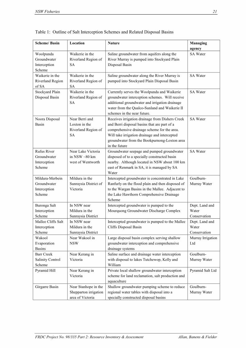
NSW Fisheries 21
FRDC Project No. 98/335 Part 2: Resource Inventory & Assessment Allan, Banens & Fielder
Table 1: Outline of Salt Interception Schemes and Related Disposal Basins
Scheme/ Basin Location Nature Managingagency
WoolpundaGroundwaterInterceptionScheme
Waikerie in theRiverland Region ofSA
Saline groundwater from aquifers along theRiver Murray is pumped into Stockyard PlainDisposal Basin
SA Water
Waikerie in theRiverland Regionof SA
Waikerie in theRiverland Region ofSA
Saline groundwater along the River Murray ispumped into Stockyard Plain Disposal Basin
SA Water
Stockyard PlainDisposal Basin
Waikerie in theRiverland Region ofSA
Currently serves the Woolpunda and Waikeriegroundwater interception schemes. Will receiveadditional groundwater and irrigation drainagewater from the Qualco-Sunland and Waikerie IIschemes in the near future.
SA Water
Noora DisposalBasin
Near Berri andLoxton in theRiverland Region ofSA
Receives irrigation drainage from Dishers Creekand Berri disposal basins that are part of acomprehensive drainage scheme for the area.Will take irrigation drainage and interceptedgroundwater from the Bookpurnong-Loxton areain the future
SA Water
Rufus RiverGroundwaterInterceptionScheme
Near Lake Victoriain NSW ~80 kmwest of Wentworth
Groundwater seepage and pumped groundwaterdisposed of to a specially constructed basinnearby. Although located in NSW about 100 kmeast of Renmark in SA, it is managed by SAWater
SA Water
Mildura-MerbeinGroundwaterInterceptionScheme
Mildura in theSunraysia District ofVictoria
Intercepted groundwater is concentrated in LakeRanfurly on the flood plain and then disposed ofto the Wargan Basins in the Mallee. Adjacent tothe Lake Hawthorn Comprehensive DrainageScheme
Goulburn-Murray Water
Buronga SaltInterceptionScheme
In NSW nearMildura in theSunraysia District
Intercepted groundwater is pumped to theMourquong Groundwater Discharge Complex
Dept. Land andWaterConservation
Mallee Cliffs SaltInterceptionScheme
In NSW nearMildura in theSunraysia District
Intercepted groundwater is pumped to the MalleeCliffs Disposal Basin
Dept. Land andWaterConservation
WakoolEvaporationBasins
Near Wakool inNSW
Large disposal basin complex serving shallowgroundwater interception and comprehensivedrainage systems
Murray IrrigationLtd
Barr CreekSalinity ControlScheme
Near Kerang inVictoria
Saline surface and drainage water interceptionwith disposal to lakes Tutchewop, Kelly andWilliam
Goulburn-Murray Water
Pyramid Hill Near Kerang inVictoria
Private local shallow groundwater interceptionscheme for land reclamation, salt production andaquaculture
Pyramid Salt Ltd
Girgarre Basin Near Stanhope in theShepparton irrigationarea of Victoria
Shallow groundwater pumping scheme to reduceregional water tables with disposal into aspecially constructed disposal basins
Goulburn-Murray Water
22 NSW Fisheries
FRDC Project No. 98/335 Part 2: Resource Inventory & Assessment Allan, Dignam, Banens & Fielder
Most of these salt disposal schemes are based on groundwater interception, with a coupleinvolving saline water-table pumping and/or comprehensive drainage schemes. They can begrouped into three main geographic regions corresponding to major irrigation regions and knownareas of highly saline groundwater, namely:
1. the Riverland Region of SA;2. the Sunraysia Region of northwestern Victoria and southwestern NSW; and3. the Riverine Plains of northern Victoria and southern NSW.
8.5.7. The Riverland Region
The Riverland Region in South Australia is a major and relatively prosperous irrigation region onthe River Murray near the NSW-Victoria border. The irrigation industry is based on horticulture,principally fruit and grapes for wine production, with various horticulture-related secondaryindustries such as wineries, fruit juice and fruit canning factories also found in the region. Grazingand cereal growing are other key land uses beyond the irrigated corridor either side of the RiverMurray. The Riverland Region has population of about 35,000, with major towns being Renmark(8,000), Berri (7,000), Loxton (7,000), Waikerie (5,000) and Barmera (4,500). Berri is locatedabout 2.5 hours or 235 km by Sturt Highway east from Adelaide and 100 km west of Mildura.There is an airport in Renmark although there are currently no regular air services. There is also arailway near Loxton however this is only used for grain transport at certain times of the year.
The climate of the Riverland is characterised by long hot and dry summers, with mild winters andoccasional frosts. Mean annual rainfall is very low at around 220 mm. Annual evaporation is2,300 mm, and is high throughout the year exceeding precipitation in every month. The sandysoils of the Mallee High Plains of the region typically support mallee scrub vegetation. On theother hand, the River Murray flood plain is typically characterised by heavy gray plastic, oftensaline, clay soils, with river redgum and black box gums being the dominant vegetation type in theriverine corridor.
8.5.8. The Sunraysia Region
The Sunraysia Region extends on both sides of the River Murray from Nyah, just north of SwanHill, to Lock 9, 60 km downstream of the Murray and Darling River junction. In this region theRiver Murray passes into the semi-arid mallee zone, with its wind-formed landscape, sandy soilsand mallee scrub, much of which has now been cleared for agriculture. The River Murray floodplain corridor with its red gum forests, wetlands and rich habitat for aquatic and riparian fauna andflora provides a stark contrast to the semi-arid surroundings. The largest centre in the region isMildura with a population of 21,000. The Sunraysia District in Victoria-New South Wales iscentred on Mildura, Dareton and Red Cliffs. It is similar in character to the Riverland Region.
The average rainfall of the region ranges from 355 mm in the east to 280 mm in the west, most ofwhich falls in autumn and spring. The average pan evaporation rate is about 2,200 mm - about 6times higher than the average rainfall. Summers are long and hot, with temperatures oftenreaching more than 40oC.
8.5.9. The Riverine Plains Region
The Riverine Plains of southern NSW and northern Victoria, stretching for some 250 km betweenYarrawonga and Swan Hill, are the most extensive areas of irrigated land in the Murray-DarlingBasin. The approximately 750,000 ha of land devoted to irrigation in this region can be broadlydivided into four general areas - that centred on the Victorian towns of Kerang and Shepparton,and that centred on the New South Wales towns of Wakool and Deniliquin. Nearly half of theland in this region is under irrigated pasture or fodder crops, principally for dairying, fat lambs and

NSW Fisheries 23
FRDC Project No. 98/335 Part 2: Resource Inventory & Assessment Allan, Banens & Fielder
beef cattle. The main crops are rice produced in the Deniliquin and Wakool areas of NSW, andfruit, grapes and vegetables in the Shepparton and Cobram districts. The latter produces some80% of Australia’s canned peaches, apricots and pears. Other crops include oil seed and grainlegumes.
While large parts of the Riverine Plains are ideal for irrigation because of the generally flat terrainand appropriate soils, large areas of clay soils with low permeability and poor structure, such asthe Kerang irrigation area, are not suitable for irrigated crops.
8.6. Salt Interception & Disposal Schemes
(See Table 2 for a summary of existing salinity control schemes and Appendices 2 & 3 for detailson ambient air temperatures in representative irrigation areas and representative water chemistry inselected salt interception schemes respectively).
8.6.1. Woolpunda Groundwater Interception Scheme
The Woolpunda Groundwater Interception Scheme is designed to minimise saline groundwaterinflows into the River Murray in a critical stretch of river between Overland Corner and Waikeriein South Australia. In this stretch some 200 tonnes of salt per day entered the river, and had amajor impact on domestic, industrial and agricultural users downstream. It is a MDBC fundedscheme that cost some $20.9 million to construct in 1992. It involved drilling about 50 extractionwells on both sides of the river to pump saline groundwater from the Murray Group aquifer, anddispose of it in the Stockyard Plain Disposal Basin located some 15 km west-southwest ofWaikerie outside of the flood plain. The scheme prevents large volumes of high salinitygroundwater entering the river system, and has effectively reduced river salinity at Morgan by 35.4EC on average. It saves downstream users millions of dollars of salinity-related costs associatedwith loss of agricultural productivity, corrosion, and water treatment. The Woolpunda Schemepumps about 7,000 ML of groundwater with a salinity of 20,000 mg/L (62,100 tonnes of salt)annually to the Stockyard Plains Disposal Basin (see below) located about 20 km to the southwest.
The Woolpunda Scheme has an annual operating and maintenance cost of $0.85 million, and ismanaged by SA Water. The relevant contact is Peter Forward from SA Water in Berri on 08-85952200 (or via-mail: [email protected]).
8.6.2. Waikerie Salt Interception Scheme
The Waikerie Salt Interception Scheme is a MDBC funded scheme completed in 1993 at a capitalcost $7.6 million. It consists of some 17 bores and pumps along the river either side of Waikerie tointercept the saline groundwater mound that has developed under the Waikerie irrigation area.Besides reducing the water-table, its purpose is also to relieve pressure on the underlying Renmarkaquifer which has resulted in significantly increased inflows of highly saline groundwater into theRiver Murray. The bores are connected through a single disposal main to the existing Woolpundadisposal main to the Stockyard Plain Disposal Basin. The annual disposal volume of the scheme isabout 4,000 ML, at an average salinity of 15,000 mg/L - equivalent to an annual disposal of 23,700tonnes of salt. The annual operation and maintenance cost of the scheme is in the order of $0.33million.
The Waikerie Salt Interception Scheme has resulted in a benefit of 13.6 EC in the average salinityat Morgan. It operates continuously except for maintenance and breakdown purposes, and isoperated by SA Water. The contact is Peter Forward from SA Water. (See Woolpunda above).

24 NSW Fisheries
FRDC Project No. 98/335 Part 2: Resource Inventory & Assessment Allan, Dignam, Banens & Fielder
8.6.3. Stockyard Plain Disposal Basin
The Stockyard Plain Disposal Basin currently serves both the Woolpunda and Waikerie Schemes.The basin’s use will be increased with further expansion of the Qualco-Sunlands and Waikeriestage II drainage and interception schemes. It is located about 15 km west-southwest of Waikeriein a low point in the mallee landscape. It lies within the Stockyard Plain Disposal Basin Reserve, a1,870 ha parcel of land purchased by SA Water specifically for this purpose. The total depressionarea available for disposal is about 680 ha, of which the current lake water area is around 350 ha.At present there are 4 ponding areas and a 35 ha salina mainly managed for waterbirds. Thetypical depth of the ponds is 1-2 metres, although one small area has a maximum depth of about 6metres. At the current supply level the ponds have a capacity of 5,300 ML, which can increase to11,100 ML at full supply level - 1 m higher than at present.
A buffer zone of up to 800 m surrounds the Basin. The surrounding land is generally of low valuewith grazing to the north, and some dryland cereal cropping to the south. The soils are a mixtureof wind-blown mallee sand and calcrete, with swales, a little more clayey. The disposal basin wasdesigned to take into account the leaky nature of the soils. Freshwater is available at the basin sitethrough an existing supply main that is now only used for domestic and stock water supply to afew farms in the surrounding area. Electricity is not currently available at the basin itself, althoughit is available about 5 km away. Consideration is being given to bringing power to the site to re-liftdisposal water to sub-basins higher and further away in the complex. This would be inconjunction with the development of Qualco-Sunlands and Waikerie stage II drainage andinterception schemes (see Sections 9.7.2 and 9.7.3). It has been suggested that land closer toWaikerie, with water and electrical services could be available at reasonable cost. Furthermore,access to saline water from the disposal main and the return of used water containing addednutrients from aquaculture was not considered to be a problem. Additional nutrients in the effluentcould well be a plus stimulating biological activity for the large number of waterbirds that thebasin currently hosts. The relevant contact is Peter Forward from SA Water.
8.6.4. Noora Drainage Diversion Scheme
The Noora Drainage Diversion Scheme is part of a comprehensive drainage system serving theBerri and Renmark irrigation areas in South Australia’s Riverland. The tile drainage flowscollected from these irrigation areas as well as some pumped shallow groundwater are firstdiverted to the existing Disher Creek and Berri evaporation basins. Following some accumulationand concentration in these basins, the water is then pumped to the Noora Disposal Basin. TheNoora Disposal Basin was constructed to relieve small existing and inappropriately locateddisposal basins in the area, and is located in mallee country some 20 km east-southeast of Berriabove and away from the River Murray flood plain. Saline effluent from the Disher Creek andBerri basins is pumped via a rising main to Bookpurnong, from which it gravitates to the NooraDisposal Basin. The Noora Basin is quite large, with up to 1,000 ha being available for disposal,although only 200 ha has ever been inundated. The existing Berri-Noora disposal main issignificantly under-utilised, as in recent years the need for disposal from these basins has declined,in part because of improved irrigation practices. Inflow has been intermittent in recent years suchthat Noora Basin has become ephemeral, and has on occasions dried up. Consequently, its aquatichabitat that has previously attracted large numbers of waterbirds is under threat. Some 44,000tonnes of salt annually are diverted from the river by the scheme, equating approximately to anannual disposal volume of 2,500 ML at a typical salinity of around 18,000 mg/L.
There is currently a proposal to significantly expand the use of the Noora Disposal Basin, bydisposing of intercepted saline groundwater from the nearby Bookpurnong area, and drainageeffluent from the Loxton Comprehensive Drainage Scheme. These additional flows could bedirected to the Noora Basin through a new pipeline, or disposed of via the existing Berri-Noora
NSW Fisheries 25
FRDC Project No. 98/335 Part 2: Resource Inventory & Assessment Allan, Banens & Fielder
disposal main. Given the Basin’s available capacity, the additional flows from the combinedBookpurnong-Loxton scheme are more than capable of being accommodated. It would at the sametime assure the Basin’s future as an attractive aquatic habitat. Consideration is also being given toits use in conjunction with a possible North Pike-Murtho salt interception scheme located nearParinga.
Construction of stage 1 of the Noora Disposal Basin Scheme commenced in 1980, with stage 3completed in 1984 at a total cost of approximately $12 million. Its annual operation andmaintenance costs are around $80,000.
Noora Basin is a natural depression in good dryland cropping country devoted mainly to cereals.The soils of the area are coarse sandy soils, which are largely reworked Loxton-Parilla Sands, withthe disposal basin designed to take advantage of the leaky nature of the soil. Electricity andfreshwater are not directly available at Noora Basin, but are available nearby – local farms have a‘poly water network’ from the river, and ‘single wire earth return’ (SWER) power lines. There is arailway line adjacent to Noora Basin that passes through Loxton to Adelaide, however it is onlyused at selected times of the year for grain transport.
8.6.5. Rufus River Groundwater Interception Scheme
Rufus River is located in NSW just north of the River Murray some 20 km from the SouthAustralian Border. It is a short river joining Lake Victoria, a large natural depression of some11,000 ha, to the River Murray. The Rufus River Groundwater Interception Scheme lies betweenthe Riverland and Sunraysia regions, but will be considered as part of the Sunraysia region for thepurposes of this review. Inflows of highly saline groundwater from the extensive Parilla Sandsaquifer in the region to the Rufus River and nearby creeks, and ultimately to the River Murrayhave significantly increased as a result of the operation of Lake Victoria as a regulating storage.This at times results in water levels in Lake Victoria being up to 7 metres above that in the RufusRiver and River Murray. It has been estimated, that under average conditions, this results in some130 tonnes of salt per day entering the Rufus River, and ultimately the River Murray.
The Rufus River Groundwater Interception Scheme was commissioned in 1984 under the MDBC’sS&D Strategy at a capital cost of $3.2 million to reduce saline groundwater inflow in the LakeVictoria area. The scheme annually diverts, on the average, around 1,400 ML of groundwater at asalinity of 30,000 mg/L from the Rufus River. This is equivalent to an improvement of 18 EC inmedian salinity at Morgan. The Scheme essentially involves the installation of 178 well-points infour lines, two east and two west of the Rufus River, each line with a well point pumping stationand rising main. It also includes an additional pumping station to take saline groundwater seepagefrom the adjacent Brilka, Little Brilka and Mungo Creek system, and a small balancing storagecreated from a meander loop of the Rufus River. A major pumping station and rising maintransfers water from the interception scheme to an evaporation basin some 5 km to the northwest.The scheme does not operate during high river flows, and on average pumps around 275 days peryear. It has an annual operating and maintenance cost of around $200,000.
The specially constructed evaporation basin is located in saltbush country, and consists of a seriesof 5 or so depressions linked by excavated channels, with water retained by 2 embankments 1.3and 0.5 km long. The maximum depth of these bays is less than 1 m. The land tenure around thedisposal basin is a mixture of state forest, land owned by SA Water and leasehold. The leaseholdland is used for grazing on the saltbush and dispersed mallee country. The soils around thedisposal basin site are the typical sandy-calcrete soils associated with mallee country. There is nopower or freshwater in the immediate vicinity of the disposal basin, although these are available atthe interception site about 5 km away or from surrounding properties. Wentworth, 80 km to theeast via the Sturt Highway, is the nearest town, while Renmark is 100 km to the west. The basinhas negligible environmental value. Peter Forward from SA Water in Berri is the relevant contact.

26 NSW Fisheries
FRDC Project No. 98/335 Part 2: Resource Inventory & Assessment Allan, Dignam, Banens & Fielder
8.6.6. Mildura-Merbein Groundwater Interception Scheme
A significant increase in River Murray salinity of up to 170 EC at regulated flows was measuredbetween Mildura and Merbein, as a result of significant inflows of highly saline groundwater inthis area. The volume of this inflow was estimated to be around 10 ML/day just from theVictorian side of the reach. In the late 1970s work was undertaken in both NSW - theBuronga/Mourquong Scheme - and Victoria - the Mildura-Merbein Interception Scheme - tointercept and divert this saline groundwater to evaporation basins. An upgrade to the Mildura-Merbein Scheme as part of the MDBC’s S&D Strategy was undertaken in 1991. The salinityreduction in the River Murray, as a result of this Scheme are around 19 EC on average, and up to70 EC during low flows.
The Mildura-Merbein Groundwater Interception Scheme consists of 17 groundwater interceptionbores with pumps located about 600 m apart and about 150 m south of the River between Milduraweir and the Merbein township. Disposal of the intercepted water from these bores is initially toLake Ranfurly, a natural shallow depression located on the flood plain 1 km south of the Murray.The effluent from the groundwater interception scheme is first concentrated in Lake Ranfurly. It isthen pumped via an existing Lake Hawthorn-Wargan basins reinforced cement (RC) pipeline to theWargan evaporation basins located further away off the flood plain. Lake Hawthorn, immediatelyadjacent to Lake Ranfurly, has been used as an irrigation tile-drainage disposal site since 1968,with saline effluent, concentrated in Lake Hawthorn, disposed of to the Wargan basins via a 13 kmlong RC pipeline. The Wargan basins are 5 interconnected basins with a total capacity of 10,700ML and a maximum surface area of 690 ha, and a net evaporative capacity of 10,200 ML/year.
Because some of the intercepted groundwater was found to be potentially aggressive, LakeRanfurly has been operated as 2 separate basins through the use of a dividing bank. The east LakeRanfurly basin (933 ML, 138 ha) is used to concentrate the aggressive water which is pumpedseparately to the Wargan basins via a PVC pipeline. The west Lake Ranfurly basin (482 ML, 81ha) is used for the non-aggressive water.
The operation of the Mildura-Merbein Groundwater Interception Scheme is dependent on RiverMurray salinities and flow levels. The groundwater pumps operate when the flow in the Murray isless than 10,000 ML/day or when the flow at Merbein is between 10,000 and 20,000 ML/day andthe river salinity at Merbein is above 420 EC. In reality however, the Scheme operates in all riverflows up to 15,000 ML/day regardless of salinity. This means that the pumps only operate for 8months or about 245 days per year, although this can vary significantly from one year to the next.Annual intercepted groundwater discharge to Lake Ranfurly is estimated to be 3,500 ML at asalinity of around 35,000 mg/L. About 61% of the salt inflow to Lake Ranfurly is pumped on tothe Wargan basins - the remaining 39% is lost by seepage ultimately back to the interceptionpumps and the River Murray. Pumping from Lake Ranfurly to the Wargan basins is automatic andsimply operates on the water level in the former. Annual disposal from both lakes Ranfurly andHawthorn (the Lake Hawthorn Drainage Diversion Scheme) to the Wargan basins over the past 7years has been around 6,000 ML at a salinity of 62,000 mg/L, totalling some 37,000 tonnes of salt.
The adjacent Lake Hawthorn Drainage Diversion Scheme receives irrigation drainage from theMildura-Merbein area, stormwater from the city of Mildura as well as natural saline groundwaterinflows. It is operated conjunction with the Mildura-Merbein Groundwater Interception Schemeby Goulburn-Murray Water. Lake Hawthorn has a volume of 4,400 ML, a surface area of 214 ha,and an average salinity of 3,000-3,500 mg/L. It has not been considered further in this reportbecause of its location on the flood plain.
Lakes Ranfurly and Hawthorn are largely located within residential areas, although there is alsosome horticulture around Lake Hawthorn. Although electricity and freshwater are readily
NSW Fisheries 27
FRDC Project No. 98/335 Part 2: Resource Inventory & Assessment Allan, Banens & Fielder
available at these sites their residential status makes them less suitable for aquaculture. Land usearound the Wargan basins is private dryland cropping and grazing, although the Wargan basins siteitself is Crown land. Power is available nearby, and while no freshwater is available at the site, itis likely to be available within 1-2 km. It has been suggested that one of the two disposal pipelinesmight be able to be used to provide freshwater when it is not being used for disposal. None of thebasins has a high environmental value or status. Soils around the Wargan basins are the typicalsandy soils found throughout the Sunraysia Region.
The relevant management contact is John Ginnivan from Goulburn-Murray Water at Tatura on 03-5451 0140.
8.6.7. Buronga Salt Interception Scheme
The Buronga Salt Interception Scheme in NSW 2-3 km north of Mildura, is designed to intercepthighly saline groundwater entering this stretch of the River Murray, with the object of reducingaverage salinity levels at Morgan by about 11 EC. It was a NSW State scheme constructed in 1979that was subsequently upgraded by the MDBC in 1991. The total capital investment in the Schemeis in the order of $3-4 million.
The Buronga Scheme consists of a line of 6 interception bores pumping highly saline groundwaterfrom the Parilla Sands aquifer to the Mourquong Groundwater Discharge Complex about 4 km tothe north. The Mourquong Complex is a large, natural, semi-circular topographic depression some10 km in diameter located in mallee country outside of the River Murray flood plain. The disposalbasin only covers a small area of about 320 ha in the southwest end of the complex, in what wasformerly a partly vegetated playa containing a number of worked-out gypsum pits. Thegroundwater interception system pumps continuously when the flow in the River Murray is lessthan 10 ML/day, but is usually switched off during floods when dilution flows make saltinterception unnecessary. On the average it operates for 270 days per year, with an annual runningcost of around $160,000.
Since the Buronga Salt Interception Scheme commenced operation in 1979, some 2,200 ML wastewater with an average salinity of 34,000 mg/L has been disposed of annually to the Mourquongsite. Saline groundwater is disposed of at the southern end of the disposal basin, from where thewater flows westward and northward to form a large shallow pond about 5 km2 in area.Evaporation along this flow path has produced a brine whose salinity varies between 91,000 and350,000 mg/L, depending on the season and rate of discharge of the disposal water. There is someexperimental food-grade salt harvesting being undertaken at Mourquong and an application for afull mining licence is currently being processed.
Mourquong Groundwater Discharge Complex is adjacent and directly north of Stanley Winesvineyards on the Sturt Highway between Buronga and Dareton about 8 km from Mildura. It isopposite the vineyards on the other side of the highway. The immediate area around the disposalcomplex is Crown land vested in the DLWC. Besides the Stanley Wines, Simeon Wines, and afew other vineyards, the surrounding land is Western Leasehold land used for dryland grazing andoccasional cropping. Small parcels of land should not be too difficult to acquire in the region.Power and freshwater supplies are not available on-site but are available nearby. The soils of theregion are sandy loams with occasional calcrete and gypsum, which are underlain by Blanchtownclays. There is no environmental value or status associated with the Mourquong disposal basin.As a site for possible aquaculture development it is considered superior to the nearby Mallee CliffsScheme by DLWC’s contact at Dareton, Mike Ernie (phone: 03-5027 4303).

28 NSW Fisheries
FRDC Project No. 98/335 Part 2: Resource Inventory & Assessment Allan, Dignam, Banens & Fielder
8.6.8. Mallee Cliffs Salt Interception Scheme
The Mallee Cliffs reach of the River Murray around Lambert Island (about 25 km southeast ofMildura on the NSW side of the river) has long been known to receive significant volumes ofhighly saline groundwater from an underlying aquifer system. This 4 km stretch of the river canadd over 30 EC at low flows, equating to an input of about 105 tonnes of salt per day. At times ofhigh river-level, salt intrusion is prevented because water flows from the River into the ParillaSands aquifer.
The Mallee Cliffs Salt Interception Scheme was developed and funded under the MDBC’s S&DStrategy to reduce salinity levels in the lower River Murray. The Scheme was designed to reduceriver salinity levels locally by about 18 EC, and by about 8.8 EC at Morgan in South Australia. Itwas completed in 1995 at a total project cost of $12.2 million, and has an annual operating andmaintenance cost of $0.47 million.
The Mallee Cliffs Scheme involves a series of seven interception bores up to 45 m deep andspaced over 4 km adjacent to the river where large inflows to the river had been detected.Submersible pumps located at the bottom of these bores pump between 1.2-5 ML groundwatereach day from the Parilla Sands aquifer. This water is disposed of via a 500 mm diameterpolyethylene pipeline to a disposal basin located 14 km northeast of the river. This speciallyconstructed 110 ha disposal basin is divided into four cells for management flexibility and toreduce wind-driven waves and associated bank erosion. Windbreaks have also been established atkey locations around the basin. Water depth in the basin varies between 1 and 4 metres, and thebasin has the capacity to contain water from 12 months of continuous pumping.
The system is operated continuously, but is shut down during high river flows, during which majormaintenance is performed on the system. Typically pumping occurs on about 270 days per year.System operation is automatic, with system status information and alarms displayed at DLWC’sDareton office. The average annual pumped volume is in the order of 2,000 ML, with typicalgroundwater salinity levels of around 35,000 mg/L
An 80 mm diameter, 14 km long freshwater supply line and associated pump station providesfreshwater at the rate of 2 L/sec at the basin site. It was installed to provide water for constructionactivities, the establishment of tree windbreaks, and to supply landholders affected by theconstruction of the disposal basin. Electricity is not available on site, but is available in thevicinity.
Most of the land surrounding the disposal complex is natural bush. The disposal basin is locatedadjacent to the Mallee Cliffs National Park on the north. Protection measures for the park andsurrounding land have included the construction of clay cores in the embankment walls to restrictleakage to local shallow water-table aquifers. The bottom of the basin is located in Blanchtownclay. The disposal basin is located on land owned by the DLWC. The remaining land use aroundthe basin is Western Leasehold land used for grazing. Soils are sandy loams with calcrete, butwithout gypsum. There is no environmental value or status associated with the basin. Therelevant contact is Mike Ernie from DLWC at Dareton on 03-5027 4303.
8.6.9. Barr Creek Salinity Control Scheme
The Barr Creek drains a large part of the Kerang irrigation district. It intercepts shallowgroundwater and also collects large salt loads from surface wash-off during heavy rain. Althoughits flow is quite small, Barr Creek is the largest point source discharge of salt (160,000-250,000tonnes annually) to the River Murray. The Barr Creek Salinity Control Project was installed in1968 and has the capacity to intercept about 20% of the average flow from this stream and pump it

NSW Fisheries 29
FRDC Project No. 98/335 Part 2: Resource Inventory & Assessment Allan, Banens & Fielder
into evaporation basins. The remainder drains into the Lodden River and thence into the RiverMurray. Water from Barr Creek is pumped via a number of constructed channels into lakesTutchewop, William, Little and Kelly that are located between Kerang and Swan Hill in north-central Victoria. The lakes form part of the Kerang Lakes system of natural depressions andassociated lunettes - small crescent-shaped dunes on eastern lake margins - on the flood plain ofthe Avoca and Lodden rivers.
Until 1968 Lake Tutchewop was a predominantly freshwater terminal lake of the Avoca Riversystem, and was subjected to annual flooding. With the construction of the Barr Creek-Tutchewopdrainage channel, the lake was isolated to become the largest of the disposal basins for the BarrCreek groundwater-pumping scheme. The other disposal basins, lakes Little, Kelly and William,are also linked to the saline-water drainage channel. Formerly these were isolated salt lakes fed bysaline springs, and were regularly harvested for salt. A MDBC project to trial harvesting of high-value salt is about to be undertaken in Lake Tutchewop by Geo-Processors. The objective of thisproduction trial would be the separation of low-concentration (rare) salts from the dominantordinary sodium chloride.
The annual volume of saline water diverted under the Barr Creek Salinity Control Scheme is in theorder of 11,000 ML, with typical effluent salinity levels around 5,000 mg/L. The salinity range ofthe diverted water is from 3,500 to 8,500 mg/L, depending on the year and the time of the year.Capital cost for the whole scheme is in the order of $6 million, with maintenance and operatingcosts of less than $0.1 million.
Freshwater and power are available at Lake Tutchewop, but not directly available at the lakesWilliam and Kelly sites, although they should be available within 1-2 km. Further detail on thelakes Tutchewop, Kelly and William are provided in Sections 7.3.1, 7.3.4 and 7.3.6. The principalcontact for the scheme is John Ginnivan from Goulburn-Murray Water at Tatura on 03-5451 0140.
8.6.10. Wakool Salinity Control Scheme
The Wakool Salinity Control Scheme is a large regional groundwater interception schemedesigned to reduce the extensive and severe waterlogging and salinity problems affectingproperties in the Wakool area of southern NSW. The scheme was constructed in two stages in1982 and 1988 from four farms totally degraded by the surface expression of saline groundwater.It consists of some 54 shallow groundwater pumps typically located at depths of 10-12 metres, andspread over an area of some 15-20 km. These pump around 13,000 ML per year through two mainpipelines into two major disposal basins comprising around 1,600 ha in total. Each basin isdivided into a series of holding and crystallisation ponds that are designed to hold water to a depthof 1 m. The salinity of the pumped groundwater is relatively constant at around 15,500 mg/L.
The scheme has been particularly successful at shallow groundwater control, with a greater than 2m reduction in water-table depth over an area of around 25,000 ha. Lesser but still significantreductions in water-tables have occurred over a further 50,000 ha. This has resulted in areclamation of formerly salinised farmland, and has also arrested and reversed the decline inagricultural productivity of the region. There have also been significant environmental, social andcommunity benefits from the scheme. For example, the Wakool Shire Council has substantiallybenefited from the greatly reduced damage to roads and sewerage systems caused by shallowsaline groundwater. Within the Wakool village (population 200) the water table reduction hasenabled septic tanks to function properly again. Although not designed to reduce salinity in theRiver Murray, the Wakool Scheme now also results in a reduction in EC at Morgan.
Soils in the area of the disposal complex are generally medium clays to sandy loams. Three-phasepower is available at the site, and while freshwater is not currently available on-site, it is availablewithin a few kilometres. Murray Irrigation Ltd, the operator, is currently in the process of

30 NSW Fisheries
FRDC Project No. 98/335 Part 2: Resource Inventory & Assessment Allan, Dignam, Banens & Fielder
negotiating the construction of a freshwater dam and supply pipeline adjacent to the complex. Theland surrounding the disposal complex is private freehold land and largely devoted to irrigatedpasture and irrigated cereal production. Availability of land is not considered to be a problem –indeed it is suggested that surrounding landowners as well as Murray Irrigation would beparticularly interested in the establishment of a new industry such as aquaculture. Two companiesare presently considering or in the process of establishing a salt harvesting industry at the Wakooldisposal complex. NSW Fisheries is currently trialing saline aquaculture in some of the Wakoolponds using snapper.
Originally built by the NSW government at a cost of $28 million, the Wakool Salinity ControlScheme is now owned and operated by Murray Irrigation. Annual operation and maintenancecosts of the scheme are around $0.35 million. The relevant management contact is Carl Mathersfrom Murray Irrigation Ltd at Wakool on 03-5887 0400.
8.6.11. Girgarre Salinity Control Project
Girgarre Salinity Control Project is a small, sub-regional groundwater interception scheme. It wasdesigned to reduce the widespread and severe waterlogging and salinity problems affectingproperties in the Stanhope/Girgarre area of northern Victoria. The scheme consists of threeshallow groundwater extraction pumps several kilometres apart and a 30 ha groundwater disposalbasin. Two of the groundwater pumps discharge moderately saline water (about 2,500 and 5,200mg/L) into the Deakin Main Drain, which discharges to the River Murray upstream of Echuca.The third pump discharges its high salinity groundwater (11,500 mg/L) to the Girgarre basinlocated about 5-6 km north of Stanhope, although at times of high flow this is sometimes alsodischarged to the Deakin Main Drain. The Girgarre evaporation basin is divided into three mainbays, which are operated to progressively concentrate the salinity of the effluent. The disposalbasin configuration also includes eight small bays that were initially used to trial various floortreatments. The Girgarre system is operated continuously during summer and automatically duringwinter, depending on groundwater and evaporation basin levels. It became fully operational inSeptember 1987.
Capital cost of the scheme was around $1.3 million in 1986-1987, which equates to about $1.9million in present day terms. Annual operating cost is about $0.03 million.
The annual disposal volume to the basin is around 410 ML/yr at a salinity of about 10,700 mg/L.Similar volumes are discharged to the Deakin Main Drain by the other two lower-salinity pumps.The salinity of bay A of the Girgarre basin is relatively constant at around 12,000 mg/L, while thatof bay B fluctuates between 15,000 and 33,500 mg/L, but appears to be gradually increasing. Thesalinity of bay C has progressively increased from 33,000 to around 91,000 mg/L since operationof the scheme. There is some seepage beneath the basin. This is, however, being recycled by thehigh salinity pump, and should extend the life of the basin indefinitely.
Extensive monitoring has shown that the operation of the Girgarre Salinity Control system haseffectively reduced groundwater levels over an area of 1,000 ha by at least 0.3 m. This hasenabled not only reclamation of salt affected pastures, but also a significant increase in agriculturalproductivity. The relevant contact is Peter Dickinson from Goulburn-Murray Water at Tatura on03- 5833 5681.
8.6.12. Pyramid Hill Groundwater Interception & Salt Harvesting Scheme
Decades of irrigation in northern Victoria have left farmland in the Loddon Plains degraded,saline, and with high water tables. Pyramid Salt Pty Ltd established a private groundwaterinterception scheme, initially for the purpose of land reclamation and salt harvesting, but whichnow also includes aquaculture. The scheme involves pumping saline groundwater from shallow,

NSW Fisheries 31
FRDC Project No. 98/335 Part 2: Resource Inventory & Assessment Allan, Banens & Fielder
low-yield, ‘shoestring’ 1-2 m thick sand (silt) aquifers located at a depth of about 10-12 m througha series of small pumps spaced about 400 m apart. These 15 pumps dispose of 100,000-150,000litres of saline groundwater daily into a series of thirteen 0.3-1.0 m deep evaporation pondscovering an area of some 15 ha. Water travels through these ponds becoming progressively moresalty until it crystallises out in the final ponds. Pyramid Salt produces salt with a range of purityfor a variety of purposes, and is also looking at developing new value-added markets for salt, suchas the use of sodium hydroxide in aluminium smelting. When in full production it is expected thatthe company will produce 5,000 tonnes of salt per year. Currently bagged salt for the market istrucked to Melbourne.
The salinity of the groundwater is relatively constant around 30,000 mg/L and, despite its shalloworigin, is relatively nutrient free. Nevertheless, brine shrimp (Artemia) production is used to‘clean up’ nutrients from the final brines. The brine shrimp are grown in heated tanks andharvested for sale to the aquarium industry. Brine shrimp production has to some extent beenlimited by the low nutrient-status saline groundwater, and ways of enhancing production andculture are currently being explored. The company is experimenting with nutrient-rich cheesefactory effluent to enable more intensive brine shrimp production and harvesting. This is with theview of expanding beyond just supplying the aquarium industry to supplying the emerging fishfarm industry. Although not the primary focus of the company, brine shrimp aquaculture hasnevertheless become a profitable sideline.
The private groundwater interception scheme and its associated complex of evaporation ponds hasachieved its goal of reclaiming degraded land. Pyramid Salt has improved the agriculturalproductivity and quality of some 750 ha of surrounding farmland that was previously degraded andunproductive. It is investigating the possibilities for expansion and for placing bores for saltproduction in other parts of the district. Pyramid Salt is one of the few permanent inlandcommercial salt producers in the Murray-Darling Basin, although a number of other companies doengage in opportunistic salt harvesting in the area. Since 1993 Pyramid Salt has invested about$12 million in the scheme, with a significant expense involved in lining the evaporation pondswith plastic. The need to line the ponds arose when the clayey soils of the area were found toconsist of dispensable clays which proved unable to adequately hold salt water. (This was not aproblem with freshwater). Annual operating and maintenance costs for the scheme are about $0.2-0.3 million. The contact person is Gavin Privett from Pyramid Salt on 03-5455 1299.

FRDC Project No. 98/335 Part 2: Resource Inventory & Assessment, Page 32
Table 2: Summary Information on Existing Salinity Control Schemes (see also Figure 1)
Scheme Type of Scheme Nearest MajorTown
CapitalCost$million
Operation/Maint Cost$million/year
YearDeveloped
PumpedVolumeML/yr
TypicalSalinity mg/L
No. ofBores orWells
SurfaceWaterInterception
Associated DisposalBasins
Number ofPonds orBays
SurfaceAreaha
Maxdepthm
Woolpunda,SA
Groundwaterinterception
Waikerie, SA 20.9 0.85 1992 7,000 20,000 50 bores no Stockyard PlainDisposal Basin
4+ 350-680 1-2(max-6)
Waikerie,SA
Groundwaterinterception
Waikerie, SA 7.6 0.33 1993 4,000 15,000 17 bores no Stockyard PlainDisposal Basin
4+ 350-680 1-2(max-6)
Noora, SA Drainagediversion
Berri / Loxton,SA
12.0 0.08 1984 2,500 18,000 not yet* irrigationdrainage
Noora DisposalBasin
na 200-1,000 na
Rufus River,NSW
Groundwaterinterception
Wentworth,NSW
3.2 0.20 1984 1,400 30,000 178 wellpoints
some Rufus River disposalbasin
5 n.a. <1
Mildura-Merbein, Vic
Groundwaterinterception
Mildura, Vic #0.86 0.18 1980 &1991
3,500 (LR)6,000 (Wb)
35000 (LR)60000 (Wb)
17 bores Irrig drainage& stormwater
Lake Ranfurly &Wargan basins
2 (LR)5 (Wb)
219 (LR)690 (Wb)
na
Buronga,NSW
Groundwaterinterception
Mildura, Vic 3-4 0.16 1979 &1991
2,200 34,000 6 bores no MourquongDischarge Complex
1 320< na
Mallee Cliffs,NSW
Groundwaterinterception
Mildura, Vic 12.2 0.47 1995 2,000 36,000 7 bores no Mallee Cliffs basin 4 110 1-4
Barr Creek,Vic
Surface runoff &groundwaterinterception
Kerang, Vic 6 0.10 1968 11,000 5,000 - yes Lakes Tutchewop,Little, Kelly &William
na 1,139(total)
-
Pyramid Hill,Vic
Shallowgroundwaterinterception
Kerang, Vic ~12 0.25 1993 37-55 30,000 15 wells no Relatively smallconstructed salt-harvesting ponds
13 15 0.3-1.0
Wakool, NSW Shallowgroundwaterinterception
Deniliquin,NSW
28.0 0.35 1982 &1988
13,000 15,500 54 wells no 2 large basinsdivided intocrystallisation andholding ponds
na 1,600 1
Girgarre, Vic Shallowgroundwaterinterception
Stanhope nearShepparton, Vic
1.3 0.03 1987 410 10,700 3 no Girgarre basin &Deakin Main Drain
3 30 0.4
# Stage 2 cost only; na not available; LR Lake Ranfurly; Wb Wargan basins; * will have with new schemes

NSW Fisheries 33
FRDC Project No. 98/335 Part 2: Resource Inventory & Assessment Allan, Banens & Fielder
8.7. Proposed Salt Interception Schemes
8.7.1. Background
The increasing problems of salt accession to the River Murray, ongoing salinisation of productiveland, and the review of the MDBC’s S&D Strategy have led to a number of proposed or potentialsaline groundwater interception schemes. (See Table 3 for a summary of information and Figure 1 forlocations). Most of these salinity schemes have a positive cost-benefit ratio based on the economicissues; however, environmental and local benefits often make such schemes very attractive. Themajor salt interception schemes proposed for the Murray-Darling Basin are listed below. Each ofthese schemes - which are in various stages of conception, planning, design and evaluation - isdescribed in detail later.
Table 3: New Proposed or Planned Groundwater Interception Schemes
Scheme Location Status CapitalCost$million
Operating Cost$million
DisposalVolumeML
TypicalSalinitymg/L
Qualco-Sunlands Groundwaterand Salinity Control Scheme
Waikerie,SA Riverland
underconstruction
7.2 0.26 3,200 25,000
Waikerie (Phase IIA & IIB)Salt Interception Scheme
Waikerie,SA Riverland
will proceedin near future
5 0.4 1,600 20,000
Lindsay RiverGroundwater Interception Scheme
Mildura,Sunraysia Vic.
will proceedin near future
4 0.25 <36,000
Pyramid CreekGroundwater Interception Scheme
Kerang, Victoria will proceedin near future
10.1 0.15 2,200 30,000
Bookpurnong-LoxtonGroundwater Interception Scheme
Loxton/Berri,SA Riverland
likely toproceed
11 0.45 4,500 11,000
ChowillaGroundwater Interception Scheme
Renmark,SA Riverland
likely toproceed
9.8 0.5 24,000-36,000
North Pike-MurthoGroundwater Interception Scheme
Renmark,SA Riverland
early stage ofconsideration
2-3 1,600 10,000
Yanda CreekGroundwater Interception Scheme
Louth, (DarlingRiver) NSW
early stage ofconsideration
8.7.2. Qualco-Sunlands Groundwater & Salinity Control Scheme
The Qualco-Sunlands Groundwater & Salinity Control Scheme is currently being constructed about10-15 km northwest of Waikerie in SA’s Riverland. Its purpose is to lower a rising groundwatermound underneath this expanding horticultural irrigation area, and reduce the consequent highlysaline groundwater inflow into the River Murray. It is also intended to reduce crop losses, landdegradation, enable future irrigation development in the district as well as reduce local flood plaindegradation and cliff slippage. The Qualco-Sunlands Scheme would involve around 15 bores with apumped groundwater volume of 3,200 ML annually at a salinity of 25,000 mg/L. This would result inan improvement in the River Murray salinity at Morgan of some 3.5 EC. The interceptedgroundwater and drainage water would be disposed of to the existing Stockyard Plain Disposal Basin(see Section 9.6.3).

34 NSW Fisheries
FRDC Project No. 98/335 Part 2: Resource Inventory & Assessment Allan, Banens & Fielder
The capital cost of the Qualco-Sunlands Scheme of $7.2 million will be shared by state and federalgovernments and the community, with growers responsible for the operating and maintenance cost ofaround $0.30 million. The contact for the Scheme is Jim Zissopoulos, Project Manager, Qualco-Sunlands Drainage District Inc. on 08-8541 2165 (or via e-mail: [email protected]).
8.7.3. Waikerie Phase II Salt Interception Scheme
The Waikerie Phase II Salt Interception Scheme is an expansion of the existing WaikerieGroundwater Interception Scheme. It deals with the lateral flow of diluted groundwater through theUpper Murray Group aquifer into the River Murray and flood plain from the Little Toolunka reachimmediately downstream of the existing interception scheme. This salt inflow was noted in theoriginal scheme, but it was not considered cost-effective to intercept that at the time. Increasingirrigation in the Toolunka irrigation area and the Qualco-Sunlands Drainage District, and a build up ofa groundwater mound under this area have steadily increased salt input to the river. The MDBC iskeen to utilise the spare capacity of the existing Waikerie scheme to help reduce salinity at Morgan.The Phase II proposal would include the interception of saline groundwater at Ramco Bend and theLittle Toolunk reach, and an extension of the groundwater-pumping scheme being constructed for theQualco-Sunlands Drainage District (see above). Saline water from both schemes would be pumped tothe existing Stockyard Plain Disposal Basin.
The Waikerie Phase II Scheme would involve some 15-18 bores pumping an indicative volume of1,600 ML annually at a salinity of 20,000 mg/L. Capital cost of the scheme is estimated at $5 millionwith an annual operating and maintenance cost of $0.4 million. The management contact for thisproposed scheme is Peter Forward of SA Water in Berri on 08-8595 2200, (or via e-mail:[email protected]).
8.7.4. Pyramid Creek Groundwater Interception Scheme
The proposed Pyramid Creek Groundwater Interception Scheme is located immediately downstreamof Kow Swamp in the Kerang region of northern Victoria. The objective of this scheme is to preventsalt inflow to Pyramid Creek by intercepting saline groundwater over a 12.5 km reach of the creek. Itwould involve some 120 airlift pumps spaced 100 m apart on one side of the creek, intercepting 2,200ML/yr of highly saline (~30,000 mg/L) groundwater. This would be pumped to a nearby 265 haconstructed and lined evaporation basin with salt harvesting capabilities.
Construction costs are estimated at $10.13 million, with annual operating and maintenance costs ofaround $0.15 million. Investigations are at an advanced stage and are being considered by the MDBCand Victorian Government. The Pyramid Creek Groundwater Interception Scheme is a public schemethat should not be confused with the private Pyramid Salt salt-harvesting and aquaculture scheme atPyramid Hill nearby.
Contacts for further details on this proposal are Stuart Critchell from DNRE on 03-9637 8371, or MattKendall from Sinclair Knight Merz on 03-9248 3353.

NSW Fisheries 35
FRDC Project No. 98/335 Part 2: Resource Inventory & Assessment Allan, Banens & Fielder
8.7.5. Lindsay River Groundwater Interception Scheme
The Lindsay River is a 52 km long anabranch of the River Murray located approximately 100 km westof Mildura near Lake Victoria. The area between the Lindsay River and the River Murray is calledLindsay Island. Mullaroo Creek is another anabranch starting just upstream of Lock 7, which flowsinto Lindsay River, dividing it into the upper and lower Lindsay River, upstream and downstream ofthe junction. Collectively this is known as the Lindsay River Anabranch System.
The salt load into the Lindsay River is derived entirely from saline groundwater discharge from theChannel Sands and Parilla Sands aquifers. The salinities of these groundwater inflows range between6,000 and 36,000 mg/L. Although this discharge is in part natural, the regulation of the River Murray,and the operation of Lock 7 have greatly exacerbated it. On average now, 60 tonnes of salt per dayenters the Lindsay River - 50% from groundwater discharge into upper Lindsay River, and 50% intoMullaroo Creek and the lower Lindsay River. During flood recession 40% of this salt input isdischarged into the Murray River, resulting in a 3.8 EC effect at Morgan. The remaining salt is storedin saline pools that form in the upper Lindsay River.
The primary objectives of the proposed Lindsay River Groundwater Interception Scheme are asfollows:
To reduce River Murray salinity at Morgan. To redistribute salinity dilution-flows for Mullaroo Creek that will no longer be required. To improve the upper Lindsay River habitat by lowering salinity and removing saline pools. To improve the flood plain forest environment on Lindsay Island by enabling artificial flooding
and preventing rising saline groundwater tables.
The proposal is to construct between 10 and 20 tubewells at groundwater interception sites near theupper Lindsay River and Mullaroo Creek. The intercepted groundwater would be pumped eitherunder the River Murray to the existing Rufus River disposal basin in NSW, or to a location near LakeWallawalla in Victoria. The capital cost of the scheme is estimated to be about $4 million, with arecurrent operating and maintenance cost of $0.25 million. Contacts for this proposal are MikeDudding, project design engineer with SKM, on 03-9248 3100, or David Lewis, DNRE on 03-94124352.
8.7.6. Chowilla Groundwater Interception Scheme
The construction of Lock 6 on the River Murray has been the primary factor raising groundwaterlevels over the Chowilla region, levels that have resulted in significant environmental degradation inthe creeks and downstream river system. The region is a natural zone of groundwater discharge thathas been greatly exacerbated by the operation of Lake Victoria as a regulating storage. The highsalinity - 24,000-36,000 mg/L – and shallow groundwater are significant factors causing theenvironmental degradation.
The objectives of the proposed Chowilla Groundwater Interception Scheme are twofold:
To reduce EC in the River Murray at Morgan. To protect the Ramsar listed wetlands of the Chowilla flood plain that are currently under severe
threat. Ramsar listing means the wetlands are recognised as being of international importance andsome 7,000-10,000 ha of high conservation-value flood plain will be protected under the proposal.
36 NSW Fisheries
FRDC Project No. 98/335 Part 2: Resource Inventory & Assessment Allan, Banens & Fielder
The Scheme would involve pumping saline groundwater from the Parilla Sands through 18 tubewells.This groundwater would then be disposed of to one of three possible disposal sites some 10 km northof the interception site, including the originally proposed Tilmy Dams site. The proposal hasdemonstrated a significant positive cost-benefit, and is now undergoing more detailed environmentaland engineering studies and assessment. The indicative capital cost for the scheme is about $9.8million, with an annual operation and maintenance cost of around $0.5 million. Natural HeritageTrust funding has been obtained to fully develop the proposal for funding consideration by theMurray-Darling Basin Commission. The area involved in the proposal is managed by the BookmarkBiosphere Reserve1 but is owned by SA National Parks. Although located in Mallee country, thesoils at the disposal sites being considered are derived from Blanchtown clay. The surrounding landuse is principally grazing, with a network of ‘poly pipe’ providing river water to stock troughs. SWERpower may be available locally within 5-6 km from these sites. The contacts for this proposal areLeon Broster from the Murray-Darling Association on 08-8226 5995, or Peter Forward from SAWater in Berri on 08-8595 2200, (or via e-mail: [email protected]).
8.7.7. Bookpurnong-Loxton Groundwater Interception & Drainage Scheme
The Loxton and Bookpurnong irrigation areas are located on the River Murray in South Australiabetween the towns of Loxton and Berri. Recent surveys have shown that salt loads to the RiverMurray between Bookpurnong and Loxton are in the order of 160 tonnes/day, equating to a salinity of36 EC at Morgan.
The Loxton Irrigation area was established in 1948 and now diverts more than 35 GL annually forirrigation of over 3,000 ha of grapes, citrus and other fruit. An extensive groundwater mound hasformed under the Loxton irrigation area, which at its maximum height is 15 m above river level. Acomprehensive drainage scheme for the area, begun in 1964, currently disposes about 5,500 ML ofdrainage water annually to the Katarapko Evaporation Basin located on the environmentally sensitiveflood plain north of the River. This disposal volume represents only a third of the total drainage fromthe area - the remaining two-thirds going to the ever-increasing groundwater mound. The volume ofdrainage water intercepted by the system is increasing as the growth of the mound increasinglyintersects subsurface farm drains. This has placed greater pressure on the Katarapko EvaporationBasin with resultant greater leakage into the River, and increased environmental impact on thesurrounding wetlands. Salt load to the River Murray from Loxton and the Katarapko EvaporationBasin is in the order of 110 tonnes/day. The salinity of groundwater in the Loxton area is around35,000 mg/L.
There has also been rapid and continuing expansion of irrigation at the nearby Bookpurnong area. Itcurrently consists of 1,100 ha of irrigated crops, mostly grapes, citrus and almonds. The elevatedcharacter of the Bookpurnong area means that, with current irrigation practices, the irrigation area isunlikely to be threatened by water logging from the underlying groundwater mound. However theimpact of irrigation at Bookpurnong on the river is high, resulting in an increased salt load to theRiver Murray of some 47 tonnes/day.
1 The Bookmark Biosphere Reserve is located on the River Murray at the state boundary with NSW and Victoria, andcovers more than 600,000 ha, including 21 parcels of land ranging from national park to privately owned grazing land.It is part of a world-wide network of 330 Biosphere reserves in 83 countries under the UNESCO Man and theBiosphere Program. The functions of a Biosphere Reserve include conservation of species diversity, research,environmental monitoring, education, and the development and promotion of ecologically sustainable development.

NSW Fisheries 37
FRDC Project No. 98/335 Part 2: Resource Inventory & Assessment Allan, Banens & Fielder
The proposed scheme is as follows:
Interception of saline groundwater from the Bookpurnong area. The diversion of Loxton Comprehensive Drainage Scheme effluent away from the Katarapko
Evaporation Basin. The disposal of both groundwater and drainage water to the Noora Disposal Basin.
The two options being considered for water disposal are, either through the existing under-utilisedBerri-Noora disposal main, or pumping directly to the Noora Basin through a new pipeline. TheNoora Basin is located approximately 20 km east-northeast of Loxton, and receives drainage flowsfrom Disher Creek and Berri Evaporation basins, which respectively serve Renmark and Berriirrigation areas (see Section 9.6.4). In recent years the need for disposal from these basins to theNoora Basin has declined, in part because of improved irrigation practices, with inflow becoming sointermittent that Noora is now ephemeral. It is suggested that flows from the combined Loxton-Bookpurnong scheme would assure the Basin’s future as an attractive aquatic habitat, which wasbeing threatened by the current low flows.
The indicative capital cost for the proposed scheme is $11 million, with a likely operating andmaintenance cost of around $0.45 million. The estimated disposal volume from both schemes isaround 4,500 ML annually, at an average salinity of around 11,000 mg/L. Peter Forward from SAWater in Berri is the relevant contact.
8.7.8. North Pike-Murtho Salt Interception Scheme
Recent ‘run of the river’ studies have shown that the North Pike-Murtho area - 10 km east of Paringaand south of the River Murray in SA’s Riverland - has contributed significant quantities of salt to theRiver. As has occurred around Waikerie and Loxton, this is as a result of a groundwater moundforming under irrigation areas along the river which is forcing highly saline groundwater into theriver. The principal land use of the area is irrigated horticulture, with grazing further away from theRiver. The North Pike-Murtho Groundwater Interception Scheme is currently at the concept stageand probably still 5 years away from construction. It is envisaged that the proposed Scheme wouldintercept and dispose of about 1,600 ML of groundwater annually with a salinity of around 10,000mg/L. The Noora Disposal Basin some 15 km away is currently seen as the most attractive disposalsite. The scheme is likely to be state owned, and involve capital costs in the order of $2-3 million.The contact for this proposed scheme is Peter Forward from SA Water in Berri.
8.7.9. Yanda Creek Groundwater Interception Scheme
Yanda Creek located on the Darling River near Louth in New South Wales has for some time beenknown to be the location of a major saline groundwater inflow to the Darling River. The YandaCreek Groundwater Interception Scheme proposal is currently at a preliminary stage. It has beengiven a fairly low priority on the basis of its initial economic cost-benefits and its limited ability togenerate EC reduction at Morgan in SA. Mike Williams from the DLWC on 02-9895 7706 is one ofthe proponents of this scheme.
38 NSW Fisheries
FRDC Project No. 98/335 Part 2: Resource Inventory & Assessment Allan, Banens & Fielder
8.8. Permanent Victorian Saline Lakes
8.8.1 Background
Australia, given its general aridity and temperature range, is renowned for its numerous and very largesalt lakes. Most of these salt lakes, however, are shallow ephemeral lakes or playas (dry salt pans)that may contain water only very infrequently. The most famous of these is Lake Eyre in SA, whichfills only once or twice every 100 years, but when filled constitutes a massive body of saline water,which may exist for several years. The ephemeral nature of such lakes, their generally highly variablesalinity, isolated location, as well as the lack of freshwater, means that these are generally unsuitablefor the development of a saline aquaculture industry. There are nevertheless a number of permanentsaline lakes, particularly in Victoria that have the potential to be suitable for aquaculture. These arethe Kerang Lakes around Kerang in northern Victoria and the Western District volcanic lakes aroundColac in south-central Victoria. (See Table 4 for a summary of information on permanent KerangLakes and Figure 1 for locations).
8.8.2. The Kerang Lakes System
The Kerang Lakes are a system of some 57 lakes and swamps of widely differing permanence, depth,salinity and degree of aquatic vegetation and which provide important waterbird habitat for largenumbers of endemic and migratory species. They are located on the northern Lodden Plain near thewestern arm of the Riverine Plains of the Murray Basin, some 330 km northwest of Melbourne. Mostof the Kerang Lakes lie within a radius of about 25 km of each other. Table 8.4 summarizesinformation on selected saline Kerang lakes.
Origins:The Kerang Lakes are a series of deflation basins - created by wind excavation in an arid climate - ina zone of natural regional groundwater discharge. Most of the 40 plus lakes are lake-lunettecomplexes, with small crescent-shaped dunes or lunettes composed of clay-gypsum on the eastern orlee side of the lakes, suggesting historical wetting and drying cycles. Many of the larger Kerang lakesare round, oval or kidney shaped. Prior to European settlement most of these lakes were ephemeral.However, extensive flood irrigation since the late 19th century has greatly enhanced recharge toregional groundwater so that now all lakes are maintained at relatively constant water levels. Salinityin the lakes ranges widely from fresh to salt levels several times that of seawater. A number of thelakes are used for irrigation supply, whilst others are used for saline drainage and groundwaterdisposal.
Regional land use, infrastructure and climate:The central town of the Kerang lakes region is Kerang with a population of around 4,500. The lakesregion around Kerang is part of the Torrumbarry irrigation area, and largely consists of irrigatedpastures mainly for fat lamb and beef cattle production, based on broad-scale flood irrigation. Somecereal, fodder, lucerne, sunflower and citrus crops are also produced in the area. Mixed farmingbased on irrigation in the region is now only marginally profitable, and faces major environmentalproblems and constraints principally associated with rising water-tables and salinisation (Wasson etal., 1996). The proximity to the River Murray, and the extensive series of lakes and waterways in theKerang area, have also resulted in a significant tourist industry. Many of these lakes are used forwater sports such as boating, skiing, fishing and swimming, and are popular picnic and camping areas.Numerous waterbirds are found in the area and Middle Reedy Lake just north of Kerang is believed tohave the world’s largest ibis rookery. Some of the lakes, for example Lake Kangaroo, are used forwater supply, while others such as Lake Tutchewop are used for the disposal of saline irrigation
NSW Fisheries 39
FRDC Project No. 98/335 Part 2: Resource Inventory & Assessment Allan, Banens & Fielder
drainage water. Salt production is currently undertaken at Pyramid Hill some 40 km southeast ofKerang by Pyramid Salt Pty Ltd.
Swan Hill, population around 10,000, is located at the northern boundary of the Kerang lakes region.It is a regional service centre principally for the irrigation-based horticulture - vineyards, stonefruitand market gardening – as well as dairying and livestock industries. First settled around the middle ofthe 19th century, Swan Hill became a major inland port of the inland river trade. The clearing anddevelopment of the mallee for agricultural purposes and irrigation development rejuvenated SwanHill, and it became a city in 1965. Local industry includes wine production and farm machinerymanufacture.
Kerang and Swan Hill are located on the Murray Valley Highway with various other minor roadstraversing the Kerang Lakes region, which also includes a number of minor communities such as LakeBoga. A railway line linking Swan Hill to Melbourne roughly parallel to the Murray Valley Highwayused to run through the region, however the line now only extends as far as Bendigo about 100 km tothe south.
The climate of the region is semi-arid with typically hot summers and mild winters. The averagedaily maximum temperature is 22°C, while the average daily minimum temperature is 9.6°C. Rainfallmainly occurs as low intensity winter falls, supplemented by irregular summer storms, and averagesaround 360 mm per year. Average annual evaporation is 1,350 mm, and exceeds rainfall in all monthsother than June and July.
General Environmental Issues:A significant portion of the Kerang Lakes region was designated as an Australian Ramsar site (Site17) in 1982 - i.e. a wetland site of international importance. Most of these lakes have also been listedin the Directory of Important Wetlands in Australia (DIWA). Nomination of these lakes as part of aRamsar site does not and has not precluded alternative use of such resources, provided such use isconsistent with the Ramsar management objectives developed for these sites. Similarly listing in theDirectory places no specific restrictions on the use of these lake/wetland resources. It merely indicatesthat they are considered to be significant, and suggests that any proposed use should consider and besympathetic to their wetland status.
Not withstanding their Ramsar listing in 1982, no Ramsar Plan of Management has so far beenprepared for the Kerang Lakes, and there has in fact been a considerable degradation of many of theKerang wetlands since then. Those saline lakes that have been used for the disposal of salinedrainage water have particularly experienced significant changes and loss of environmental value.Changed hydrology, such as isolation from natural flood flows, has also resulted in increased salinityand modified biota in some wetlands. A number of freshwater lakes in the area are managed asholding storages for irrigation water supply, and consequently have lost some environmental value.Efforts are nevertheless being made to improve the environmental management of a few individuallakes.
8.8.3. Details of Permanent Saline Kerang Lakes
Discussion will generally be restricted to those lakes meeting the primary criteria for consideration.Information has mostly been obtained from:
Discussions with and information supplied by individuals at Goulburn-Murray Water and theDepartment of Natural Resources and Environment at Tatura.
The draft Kerang-Swan Hill Lakes Salinity Management Plan. The Directory of Important Wetlands in Australia (ANCA 1996). Environment Australia’s report to the 6th Ramsar Convention in Brisbane in 1996.

40 NSW Fisheries
FRDC Project No. 98/335 Part 2: Resource Inventory & Assessment Allan, Banens & Fielder
Various scientific and other publications.
Lake Tutchewop:Lake Tutchewop is a Ramsar and DIWA listed wetland largely because of its aquatic bird habitat.However, its environmental value has rapidly declined to a moderate level as result of its use as themain saline disposal basin for the Barr Creek Salt Interception Scheme. Its salinity has graduallyincreased from about 13,500 mg/L in 1975 to around 75,000 mg/L at present, a trend, which ifcontinued would result in salinity levels that would be unable to support much animal or plant life.Studies are being undertaken into the long-term management of Lake Tutchewop to maximise thequality of its wetland habitat and to protect its Ramsar values, whilst retaining its use as anevaporation basin. It has been proposed to lower its salinity levels to 15,000 mg/L by making use ofother lakes (William and Kelly) as final effluent disposal sites, as well through commercial saltharvesting. A commercial trial, financially supported by the MDBC, of harvesting high-value rare-salts is about to be undertaken at the edge of Lake Tutchewop. This could lead to the establishmentof a large-scale salt harvesting industry at the lake. The lake foreshore of about 75 m is Crown landwith grazing licences now discontinued. Land use surrounding the lake is mainly mixed drylandcropping of oats and barley and grazing, with a few small areas devoted to irrigated pasture.
Lake Cullen:Lake Cullen is one of the larger moderately-saline Kerang lakes. It has been Ramsar and DIWAlisted, but in contrast to Lake Tutchewop, has still retained much of its environmental value. The lakewas previously linked into the Torrumbarry Irrigation System and used as an irrigation water storage.It has now, however, been isolated from the system – presumably because of increasing salinity - andis no longer used for water supply. There is no grazing on most of the lake frontage, although thereare still a few patches that are in the process of being phased out. There is some irrigated pasture anda small pocket of irrigated lucerne on the western side of the lake. On the eastern side mixed drylandfarming, cropping and grazing is the predominant land use, although there is also a single large centre-pivot irrigation system growing lucerne in this area. Fresh water in the form of adjacent lakes – e.g.Kangaroo - and irrigation channels is relatively close by. Groundwater in the vicinity of Lake Cullenis shallow, and has a salinity level approaching that of seawater.
Lake Elizabeth:Lake Elizabeth, although not Ramsar or DIWA listed, has a moderate environmental value, with workcurrently underway to improve its environmental amenity. It is not used for saline water disposal orwater supply. As with Lake Cullen most of the foreshore frontage is no longer used for grazing.Surrounding land use is mainly mixed grazing and cropping with the occasional pockets of lowintensity irrigation to the east.
Lakes Kelly and Little:Lake Kelly and Little Lake (also known as Little Lake Kelly) are linked adjacent saline lakes that arepart of the Barr Creek Salinity Control Scheme. As a consequence, the lakes have been considerablydegraded such that they now only have low to moderate environmental value, notwithstanding the factthat Lake Kelly has been Ramsar and DIWA listed. The land surrounding the lakes is also verydegraded and consists solely of light grazing. Irrigation is undertaken further away from the lake.
Lake Wandella:Lake Wandella - locally known as Brandy’s Lake - has a moderate environmental value. Although ithas experienced an increase in salinity in recent times, this has not significantly changed itsenvironmental status. The lake is not used for saline water disposal or irrigation water supply. The80-100 m frontage to Lake Wandella is not grazed. The surrounding land to the west is used forintensive irrigated dairy farming, whereas to the north, east and south the land is mainly devoted tomixed dryland farming consisting of cropping oats and barley and grazing.

NSW Fisheries 41
FRDC Project No. 98/335 Part 2: Resource Inventory & Assessment Allan, Banens & Fielder
Lake William:Lake William is also part of the Barr Creek Salinity Control Scheme. This has caused severedegradation of the lake such that it only has a low environmental value – despite its Ramsar andDIWA listing. This degradation has extended to the lake frontage and the surrounding land, and onlylight dryland grazing occurs around the lake.
Lake Charm:Lake Charm is one of the large freshwater lakes of the Kerang area. Since the 1880s Lake Charm anda number of other lakes and streams have been used for irrigation water carriers and storage. Theoperation of the lake has resulted in it becoming slightly brackish over time so that it now has salinityof around 3,000 mg/L. New engineering works to improve the flushing of the lake should graduallyreduce its salinity to 1,500 mg/L.

42 NSW Fisheries
FRDC Project No. 98/335 Part 2: Resource Inventory & Assessment Allan, Banens & Fielder
Table 4: Specific Information on Permanent Saline or brackish Kerang Lakes (see Figure 1 forlocations)
Lake Volume(FSL)ML
Surfacearea(FSL) ha
Max.depthm
Meandepthm
Salinity*mg/L
Wetlandlisting
Principaluse orstatus
Environmentalvalue & trend
Tutchewop 13,200 775 1.7 50,000+ RamsarDIWA
saline waterdisposal
Moderate ↓
Kelly 2,260 201 1.1 45,000 RamsarDIWA
saline waterdisposal
Low-moderate ↓
Little Kelly 460 44 1.0 45,000 saline waterdisposal
low-moderate ↓
William 2,700 108 2.5 61,000 RamsarDIWA
saline waterdisposal
Low ↓
Elizabeth 94 30,000
->20,000
public land Moderate ↑
Wandella 44 30,000 public land Moderate ↔
Cullen 13,400 632 4 2.1 12,000 RamsarDIWA
previouslya watersupply
High ↔
Charm 22,000 486 4.5 3000->1,500
RamsarDIWA
irrigationwatersupply
moderate-high ↑
Lookout 1,230 61 4 2.0 ~3,000*Converted from average EC x 0.6 as reported in the Kerang-Swan Hill Salinity Management Plan (1993).
8.8.4. The Western District Volcanic Lakes
(See Table 5 for a summary of information on Western District Volcanic lakes and Appendix 4 fordetails of representative water chemistry in selected permanent saline lakes)
The volcanic plains of the Western District of Victoria, some 160 km west-southwest of Melbournecontain a significant number of permanent saline lakes, including Australia’s largest permanent salinelake, Lake Corangamite. While some of these salt lakes are shallow and subject to substantial salinityvariation in association with flooding or heavy rain, a number of them are quite large and moderatelydeep. The salinity of the western district lakes ranges from hypersaline - Lake Gnotuk ~58,000 mg/L- through to virtual freshwater - Lake Purrumbete ~400 mg/L. Most of the lakes lie within a 25 kmradius of each other. Information on these lakes for this report has mostly been obtained from DeDeckker & Williams (1988); Williams (1981); Williams (1978); Timms (1976, 1983) and ANCA(1996). Discussion will generally be restricted to those lakes meeting the primary criteria forconsideration.
Origins:The origins of the lakes in the Western District are diverse, but are generally the result of formervolcanic activity which occurred between the Pleistocene and about ~5-7,000 BP. The oldest carbon-dated age is of Lake Keilambete at around 30,000 BP, however most lakes are considerably younger.Some are maar lakes, for example lakes Gnotuk, Bullenmerri, Purrumbete, Keilambete, Elingamite,Red Rock and Basin. Others are volcano crater lakes – lakes Mumblin and Surprise. LakeCorangamite arose either by a volcano-tectonic process involving subsidence above a large magma
NSW Fisheries 43
FRDC Project No. 98/335 Part 2: Resource Inventory & Assessment Allan, Banens & Fielder
chamber, or possibly by the blockage of a river by a lava-flow. Some of the smaller lakes have beenformed by the collapse of lava tunnels, while some shallow eastern lakes that lie on wind- or lake-derived sediments could well be deflation basins. The region is an undulating plain with an altitudeof between 150 and 300 m. The endorheic drainage of the region means these lakes are the termini ofinland drainage basins, which coupled with large evaporation rates largely accounts for their elevatedsalinity.
Regional land use, infrastructure and climate:The Western District was originally a grassy but largely treeless undulating plain. Since settlement in1840, the fertile but shallow stony basaltic soils of the area have largely been given over toagriculture, principally sheep and cattle grazing on improved pastures, dairying and cropping. Thetwo major towns in the region are Colac with a population of 6,500 (has been over 10,000) andCamperdown about 50 km away with a population of 3,200 - both on the Princess Highway betweenGeelong and Warrnambool. Cobden 15 km south-southwest of Camperdown has a population of1,500 and has several industries, including the large Bonlac Foods Ltd milk drying plant, and theAusfeed stockfeed mill. A number of other small communities and roads dot and traverse the region.There was a rail link between Colac and Geelong.
The climate of the region is temperate, typically with warm dry summers and cool wet winters.Average annual rainfall varies between 500 mm in the north of the region to around 800 mm in thesouth. Average maximum air temperature varies from 27oC in summer to 10oC in winter. Averageannual evaporation is between 1000-1500 mm with a minimum of 50 mm during June and July, and amaximum in January of 125< mm. Evaporation usually exceeds precipitation during the ‘summer’months of October to April. Williams (1981) and references therein provide more detail.
General environmental issues:A number of the Western District lakes have been nominated as an Australian Ramsar site (Site 20) -i.e. wetland sites of international importance. Nomination of these lakes as part of a Ramsar site doesnot preclude alternative uses of these resources, provided such use is consistent with the Ramsarmanagement objectives developed for these sites. Three of the lakes listed in Table 9.5 below areRamsar listed. Most of the other lakes have been listed in the DIWA (ANCA 1996). Again the listingof these lakes in the Directory places no specific restrictions on the use of these lake/wetlandresources. It does indicate that they are considered to be significant, and that any proposed use wouldhave to be sympathetic to their wetland status. A number of the fresher lakes in the region are usedfor irrigation while others are used for industrial process water and disposal.

44 NSW Fisheries
FRDC Project No. 98/335 Part 2: Resource Inventory & Assessment Allan, Banens & Fielder
Table 5: Specific Information on Selected Permanent Saline Western District Lakes (see Figure 1 forlocations)
LakeVolumeML x 103
Surface areaha
Maxdepthm
Meandepth m
Salinity rangemg/L
Wetlandlisting
Corangamite 1,510 - 456 25,200 - 32,300 ~6.04.9
6.02.9
22,400 – 36,300 Ramsar/DIWA
Bullen Merri 192 488 66 39.3 5,000 – 9,100 ?
Purrumbete 157 552 45 28.5 300 - 430
Martin 79 4,020 <3 2 2,900 – 8,400 DIWA
Gnarpurt 70.3 - 26.5 2,730 - 2,580 <32.4
2.571.9
7,200 – 13,700 Ramsar/DIWA
Colac 52 - 71.3 2,420 - 2,970 2.22.4
1,890 - 2,500
Gnotuk 32 208 18.5 15.3 51,800 – 59,800 DIWA
Colongulac 32 1,460 3.9 2.2 8,300 – 12,100 Ramsar/DIWA
East Basin 1.24 27.4 12 7.3 DIWA
West Basin 0.92 15.8 13.5 5.8 DIWA
8.9. Saline Groundwater Resources
(See Table 6 for a summary and Figure 2 for the location of the major basins with the greatestpotential for inland saline aquaculture).
8.9.1. Background
Groundwater can be found virtually anywhere in Australia, although the quantity and quality in termsof salinity and other characteristics can vary widely from place to place. Groundwater resources areusually classified into three broad types:
Surficial aquifers: These are comparatively shallow water-table aquifers - generally comprisingunconsolidated sediment - that may constitute a variable resource and provide variable yield.Such unconsolidated sediments form a veneer over much of Australia. In areas affected bydryland salinity or under irrigation regions where groundwater accession occurs, such aquiferscan be a significant saline water resource.
Sedimentary basins: These are generally deeper aquifers consisting of layers of poroussandstone or limestone rock. They are often significant water resources with high yields, howeverthe salinity of these sedimentary aquifers is highly variable. Because of the different sedimentarylayers in such basins, they often contain a number of superimposed aquifers at different depths.
Fractured rock aquifers: These are essentially non-porous rocks such as igneous ormetamorphic rocks that have been fractured by geologic activity. Such groundwater resources areusually limited and are associated with low yields.
A hydrogeological map of Australia (Lau et al., 1987), shows where the major aquifers, in terms ofvolume and/or yield, occur around Australia. It should be remembered that groundwater resources are
NSW Fisheries 45
FRDC Project No. 98/335 Part 2: Resource Inventory & Assessment Allan, Banens & Fielder
3-dimensional, and superimposed multi-aquifer systems can not be represented easily on single-sheethydrogeologic maps. As the map indicates, groundwater can be found virtually anywhere inAustralia. However, there are several major groundwater regions in Australia where salinities of theprincipal aquifer are typically of the same order as seawater. These are:
1. The lower Murray Hydrogeological Basin extending to the Western Districts of Victoria.2. Eyre Peninsula in South Australia.3. Central Australia; principally the Northern Territory.4. The wheatbelt zone of southwest Western Australia.
Areas of brackish groundwater (indicated as 1,500-5,000 mg/L) tend to more or less surround thesehigher salinity regions, and include most South Australia, virtually all of Western Australia and largeareas of NSW, Victoria and the Northern Territory. Areas of brackish groundwater also occur in thesouthwest and eastern areas of Queensland. Only Tasmania appears to have negligible brackish orsaline groundwater.
From an inland saline aquaculture perspective, surficial aquifers and sedimentary basin aquifers arelikely to be of principal interest. Nevertheless fractured rock aquifers could also, in places, providesufficient saline groundwater for the establishment of an aquaculture industry.
Information for this report was initially accessed from agency reports and maps, via the Internet, andthrough personal discussion with agency hydrogeologists. Saline groundwater is dealt with by state.Sedimentary basins which span more than one state are only addressed under the first state for whichthey are reported. Table 6 provides a summary of the most important saline groundwater resources.
8.9.2. Victoria
Background:The Victorian government provides a useful overview of the state’s hydrogeology and groundwater inits Internet site (http://www.nre.vic.gov.au/dnre/grndwtr/grndwtr.htm). Information can also beaccessed from various agency publications, such as Water Victoria: A Resource Handbook (DWRV1989), and Groundwater Quality and the Potential Impact of Contaminants (SKM 1999). Morespecific and detailed information on local groundwater or bore characteristics can be obtained fromthe State’s groundwater database, which is managed by Sinclair Knight Merz (phone 03-9248 3100)
Hydrogeology overview:Victoria consists of an old central backbone of fractured rock called the Highland Province and anumber of younger, principally Tertiary, sedimentary basins. These are in order of size:
The Murray Basin. The Otway Basin. The Gippsland Basin. The Port Phillip Basin (comparatively minor. The Western Port Basin (comparatively minor).
Only the Murray Basin, and to a lesser extent the Otway Basin, have significant saline groundwaterresources. A few individual aquifers in the other basins and isolated pockets of the HighlandsProvince also contain some brackish groundwater. Shallow water-table aquifers may comprise anynumber of geological units across the region. They are most directly affected by land use activities atthe surface, and in many areas have significant impacts on the land use as well as wetlands, streamsand other water bodies. In Victoria brackish or saline groundwater associated with water-tableaquifers is mainly found in the western two-thirds of the State. The more saline water-table
46 NSW Fisheries
FRDC Project No. 98/335 Part 2: Resource Inventory & Assessment Allan, Banens & Fielder
groundwater is found in the northwestern corner, corresponding largely to the MurrayHydrogeological Basin. A descriptive summary of each relevant groundwater region is providedbelow.
Murray Hydrogeological Basin:The Murray Hydrogeological Basin is a large, shallow closed groundwater basin that consists of a200-600 m thick veneer of sedimentary rocks containing a number of aquifer systems. It extendsacross Victoria, NSW and SA, and corresponds approximately to the lower part of the Murray-Darling hydrological catchment, with which there is significant interaction.
Groundwater salinities in the Basin are highly variable, ranging from freshwater up to 300,000 mg/L.Most of the higher salinity (>7,000 mg/L) groundwater occurs west and north of a line throughTorrumbarry and Balranald, which corresponds approximately to the eastern extent of a palaeo-inland-sea, with salinity generally increasing to the north and west along the groundwater flow-path.
The most significant geological aquifer forming units in the Basin are the Pliocene Loxton-ParillaSands, and the Calivil Formation and the Middle-Tertiary Renmark Group, which lie at depths of 15-20 m and 25-130 m respectively. The salinities in these aquifers vary, but are typically well over13,000 mg/L. Several zones of very high salinity (35,000 mg/L) groundwater occur around theSunraysia and Riverland regions of Victoria, NSW and South Australia. Bore yields for these aquifersvary widely - between 2-125 L/sec - but are typically high. These are the aquifers from whichgroundwater interception schemes in the Murray Basin generally pump.
The Lower Renmark Group - a basal Tertiary aquifer occurring throughout the Basin - also containssubstantial saline groundwater resources at depths of between 50-420 m.The shallow nature of several saline aquifers in the Basin has resulted in the inflow of highly salinegroundwater into the River Murray. Regulation of the River and adjacent irrigation activities hassignificantly increased this salt inflow and its impact.
A substantial number of significant urban communities in the Murray Basin are underlain bysignificant saline groundwater resources. Several are discussed in relation to salt interceptionschemes, or the Kerang salt lakes. In Victoria these urban centres include Mildura, Red Cliffs,Ouyen, Robinvale, Swan Hill, Kerang and Horsham, with Shepparton, Echuca and Charlton havingaccess to brackish groundwater with salinities between 3,500-13,000 mg/L. Other major communitiesunderlain by saline groundwater include Balranald, Euston, Dareton, Deniliquin and Wentworth inNSW; and Renmark, Berri, Loxton, Barmera, Waikerie, and Morgan in SA. Smaller communitieswith access to saline or brackish groundwater resources are not listed.
Otway Basin:The main geological aquifer-forming units in the Otway Basin associated with brackish groundwaterare the Newer Volcanics. These stretch in a broad zone west from Geelong to near Hamilton. Thesegroundwaters typically have salinity levels between 2,000-8,000 mg/L. Bore yields are mostly lessthan 1.5 L/sec (0.13 ML/day), but in places can be as high as 60 L/sec (5.2 ML/day). There areseveral pockets south of Ballarat, and west of Geelong, where groundwater salinities in the NewerVolcanics get above 13,500 mg/L. The somewhat deeper Dilwyn Formation of the lower Tertiary isalso associated with brackish groundwater. It stretches in a V from near Hamilton down toWarrnambool, and then back up through Camperdown to Geelong. Salinities in this aquifer unit aregenerally above 3,500 mg/L, although in the Warrnambool area its salinity is over 5,000 mg/L. Boreyields are as high as 115 L/sec (9.9 ML/day). Around Portland in western Victoria this aquifer yieldsonly slightly brackish groundwater, with salinities between 1,000-3,500 mg/L. The interesting qualityof this groundwater is that it is geothermal and has a temperature of about 50oC.

NSW Fisheries 47
FRDC Project No. 98/335 Part 2: Resource Inventory & Assessment Allan, Banens & Fielder
Water-table aquifers, mainly in the northern half of the Otway Basin, provide brackish groundwaterwith salinities between 3,500 and 13,000 mg/L. Surficial groundwater with higher salinities above13,000 mg/L is found in a few isolated pockets.
Gippsland Basin:There are no saline and very limited brackish groundwater resources in the Gippsland Basin, withmost groundwater resources having a salinity of less than 1,500 mg/L. There is one small area just tothe east of Sale where brackish groundwater with salinity over 3,500 mg/L occurs in the upperTertiary Gippsland Limestone as well as shallow water-table aquifers. The yield for this upperTertiary Gippsland Limestone is generally less than 2 L/sec but can be as high as 10 L/sec.
Port Phillip and Westernport basins:Both the Port Phillip and Westernport basins are small sedimentary basins with negligible brackish orsaline groundwater resources. There is a limited region of brackish groundwater west of Melbournefrom Werribee to the Geelong region. The geological aquifer forming units in this region are theWerribee Delta, the Newer Volcanics, the Moorabool Viaduct Formation and the WerribeeFormation. The salinity of these aquifers is variable but nearly always less than 6,000 mg/L. Boreyields range from <1.5-50 L/sec. Water-table aquifer salinities in these basins largely mirror those ofthe underlying sedimentary aquifers.
The Highlands fractured rock province:The Highlands Province consisting of fractured rock aquifers has negligible saline or brackishgroundwater resources. Most groundwater salinity in the province is substantially less than 3,000mg/L, coupled with highly variable, though usually low, bore yields. Only the Palaeozoicsedimentary and igneous rocks of the West Victorian Highlands around the Hepburn Springs andDaylesford area yield higher salinity groundwaters. These, however, tend to be mineral waters with asubstantially different ionic chemistry composition to the typical sodium-chloride dominatedgroundwaters of other areas. The mineral groundwater from this area is bottled and soldcommercially. There are negligible saline or brackish water resources associated with water-tableaquifers.
8.9.3. New South Wales
Hydrogeology overview:New South Wales consists of five sedimentary basins, several of which are shared with adjacentstates, and four geographic fractured rock provinces. These basins and fractured rock provinces are inlarge part overlain by a thin layer of unconsolidated sediments that constitute groundwater systemsmore or less independent of the underlying aquifers.
The Great Artesian Basin (shared with Qld, NT & SA). The Murray Basin (shared with Vic & SA). The Sydney Basin. The Clarence-Morton Basin (shared with Qld). The Oxley Basin. The Western Slopes and Plains fractured rock province. West Darling fractured rock province. Central and Southern Tablelands fractured rock province. New England fractured rock province.
Of the geological groundwater units listed above, only the Murray Basin provides a significant andsuitable saline groundwater resource for aquaculture. Saline or brackish groundwater is also found inthe Great Artesian, Sydney and Clarence-Morton basins, and also to a lesser extent in the Western
48 NSW Fisheries
FRDC Project No. 98/335 Part 2: Resource Inventory & Assessment Allan, Banens & Fielder
Slopes and Plains, and West Darling fractured rock provinces. However, isolation, inappropriatechemistry and lack of freshwater rule out the Great Artesian Basin and the West Darling fracturedrock province. This leaves the Sydney and Clarence-Morton basins, and the Western Slopes andPlains fractured rock province as other locations where saline groundwater may be available andsuitable for aquaculture.
Shallow water-table aquifers in unconsolidated surficial sediments also exist across most geologicalunits. The most saline water-table groundwater is found in the southwestern corner of the State,corresponding approximately to the boundary of the Murray Hydrogeological Basin. Brackish shallowgroundwater is also found in the western two thirds of the State. Dryland salinity and rising salinewater-tables as a result of clearing of native vegetation have dramatically increased in extent in recentyears. They now constitute a significant saline problem as well as a significant potential saline waterresource over large areas of the State west of the divide.
A summary of relevant saline groundwater regions is provided below.
The Great Artesian Basin:The Great Artesian Basin is Australia’s largest sedimentary basin, and comprises a number of sub-basins, and consists mainly of Triassic, Jurassic, Cretaceous and Tertiary sediments. It extends fromsource areas in northern and eastern Queensland and northern NSW into discharge zones in inlandQueensland, NSW and northwest SA. It constitutes an important groundwater resource for thegrazing industry over much of arid inland Australia, as well as a number of mining projects. Thegroundwater from the deeper aquifer is artesian, with very high flow rates, generally fresh, and oftengeothermal with temperatures as high as 120oC. A significant portion of flow from uncapped bores iswasted through evaporation from open bore drains – however, a program of bore capping is nowunderway to conserve the resource. Water quality in terms of total dissolved solids generallydecreases along the flow path from the northeast to the southwest and with increased residence time.Some groundwater has been dated as being 2 million years old. Salinity in this deeper aquifer isgenerally dominated by sodium bicarbonate. The shallower Tertiary sediments (<200 m thick)generally contain poorer quality and more saline groundwater and also have lower yields.
Overall the Great Artesian Basin despite its extent and the magnitude of its groundwater resourcedoes not appear to be suitable for inland saline aquaculture. Its groundwater in the more populatedareas is generally fresh, with increased salinity levels generally being found in the more isolatedareas. Furthermore salinity from the principal aquifer is more mineral in character, and dominated bysodium bicarbonate. Only the shallower Tertiary aquifers, which contain higher salinity groundwater,may provide some aquaculture potential. Flows are non-artesian and yields substantially lower, butstill likely to be adequate for aquaculture. Isolation is nevertheless the main problem.
Sydney Basin:The Sydney Basin extends from Batemans Bay on the NSW south coast to Swansea in the north andinland almost as far as Dubbo and Narrabri, and includes Sydney at its centre. It consists of Permianand Triassic marine, estuarine and riverine sediments, and contains a mixture of saline and freshgroundwater resources. The basal marine sediments/coal measures, and the Wianamatta Groupprovide the principal saline or brackish groundwater resources.
The basal Permian sediments comprise marine and coal measure sequences including some volcanicsediments, and tend to outcrop around the margins of the Basin. This sedimentary layer outcropssouth of Wollongong, inland to Tallong, and north through Lithgow to the Goulburn and Hunter rivervalleys, and provides groundwater that is typically brackish. It exhibits low yields of between 0.25-2L/sec. from bores located at depths of between 30-100 m.

NSW Fisheries 49
FRDC Project No. 98/335 Part 2: Resource Inventory & Assessment Allan, Banens & Fielder
The Wianamatta Group consisting mainly of marine shales is one of three main groups of the youngerTriassic sediments in the Basin. It occurs mainly on the Cumberland Plain west and southwest ofSydney. The groundwater associated with these sediments is generally saline and occasionallybrackish, but generally provides only low yields of 0.1-2 L/sec.
The Narrabeen Group is another of the three groups of Triassic sediments, and is mainly found in thenorthern part of the Basin. It is generally associated with brackish groundwater and low (0.2-2 L/sec)yields.
Clarence-Moreton Basin:The Clarence-Morton Basin, which extends from 50 km south of Grafton north into Queensland,consists of Triassic and Jurassic sediments that include a number of coal measures. It contains arange of fresh, brackish and saline low-yield groundwater resources. The basal Triassic coal sequencein the south and southeast of the Basin is associated with high salinity groundwater. The JurassicWalloon Coal Measures, located near the centre of the Basin are similarly associated with brackish orsalty groundwater - often within 30 m of the surface. Fresh groundwater can often be obtained fromthe overlying Kangaroo Creek Sandstone, although yields are typically low (<1 L/sec).
Western Slopes and Plains fractured rock province:There are limited saline groundwater resources in the Western Slopes and Plains fractured rockprovince, which consist of extensive areas of granite, and metamorphic rocks. Groundwater is oftendifficult to find, and where it does occur, yields – as with all fractured rocks - tend to be low (<0.4L/sec). North of the Murrumbidgee River groundwater tends to become brackish and progressivelymore saline to the north and west. North of the Lachlan River and northwest of the town of Forbes,groundwater salinity is usually above 10,000 mg/L.
West Darling fractured rock province:The West Darling fractured rock province is located in the Barrier Range and northwards fromBroken Hill, and consists of Precambrian and Palaeozoic rocks. The very limited groundwaterresources of this province are invariably brackish or saline, and in large part reflect the arid nature ofthe country. Yields rarely exceed 0.3 L/sec.
8.9.4. South Australia
Hydrogeology overview:The two main saline groundwater resources in South Australia are the Murray Basin, and thesouthwestern two-thirds of the State, which include the Eyre Peninsula region. Brackish groundwaterresources are also found in the arid and largely unpopulated northwest of the State. Given that thegroundwater resources of the Murray Basin have previously been discussed in this report under anumber of headings, this discussion will now focus on the Eyre Peninsula Region.
Eyre Peninsula region:The groundwater resource in the Eyre Peninsula Region of SA consists mainly of fractured rock,which is overlain by shallow Quaternary sediments. The latter aquifer provides fresh groundwater(<1,500 mg/L) for most communities in this region. The underlying fractured rock aquifer containssaline groundwater, and while bore yields are generally on the low side they are likely to be adequatefor saline aquaculture. Further detail was unable to be obtained in time for this report. Additionalinformation may be obtained from Cobb et al., (1982). The Groundwater Division of the Departmentof Primary Industries and Resources SA (phone 08 8463 3147) can also provide additionalinformation for a fee.

50 NSW Fisheries
FRDC Project No. 98/335 Part 2: Resource Inventory & Assessment Allan, Banens & Fielder
The combination of fresh and saline water resources and significant urban communities alreadyinvolved in fisheries and/or aquaculture make this region potentially attractive for inland salineaquaculture. Cities such as Port Lincoln, Whyalla and Port Pirie, all provide significant infrastructureand labour. Port Lincoln also has major fishing and offshore aquaculture industries as well as fishprocessing plants that may enable synergies with any inland saline aquaculture. Fisheries marketpathways are already established. Because of the saline aquaculture potential of the region, a briefoverview of Port Lincoln and Whyalla is presented below.
Port Lincoln:Port Lincoln - population 14,000 - is located on the southern tip of Eyre Peninsula. It is situated onBoston Bay, a large natural deepwater harbour which is the home of Australia's largest commercialtuna fleet. A significant number of lobster fishing vessels also operate out of the port, which is alsothe centre for major bulk grain exports for much of Eyre Peninsula. Port Lincoln is 680 km fromAdelaide by road or about 280 km and 45 minutes west of Adelaide by air.
It has a moderate Mediterranean climate, which is tempered by the surrounding sea. The annualrainfall of 550 mm falls mainly in the winter months from April to September when maximumtemperatures average between 16 and 22oC. Average maximum summer temperatures range between22-27oC, with the maximum temperature rarely climbing over 35oC.
Whyalla:Whyalla is South Australia's second largest city with a population of 24,000. It is located on thenorthwestern coast of Spencer Gulf and is a centre for the northern Eyre Peninsula and Upper SpencerGulf regions. Whyalla is a 390 km drive from Adelaide, and 290 km from Port Lincoln to the south.It also has rail and port facilities. Kendell Airlines provides daily air services to Adelaide 240 kmaway.
Whyalla was a traditional steel city, with ore from nearby Iron Knob and Iron Duke used to producesteel for both domestic and export markets. Whyalla also hosts a number of other major industries,including the $4 billion SANTOS oil and gas fractionation plant at Port Bonython. The cityadditionally has a number of other smaller industries, some of which relate to aquaculture. Theseinclude commercial salt production by Pacific Salt, beta-carotene production by Betatene, and morerecently the development of an aquaculture industry in nearby Fitzgerald Bay.
There is little natural freshwater available in the Whyalla district, and water is supplied by pipelinefrom the River Murray.
Whyalla is located in a semi-arid zone, and experiences clear skies for much of the year. Meanmaximum temperature range for summer months is 24-29oC, while for the winter months it is 17-23oC. The average annual rainfall of around 270 mm is distributed throughout the year, but is lessreliable in summer. Average relative humidity ranges from about 50-55% in winter to about 35-38%in summer.
8.9.5. Western Australia
Hydrogeology overview:Large areas of groundwater resources in Western Australia are either brackish or saline. Howevermany of these areas are either too isolated or have no access to freshwater, and consequently areunsuitable for inland saline aquaculture. The main saline water resources likely to be of interest tosaline aquaculture are the Carnarvon Basin, the shallow groundwater associated with the wheatbelt,Ord River Irrigation Area and possibly the southern part of the Western fractured rock province. The

NSW Fisheries 51
FRDC Project No. 98/335 Part 2: Resource Inventory & Assessment Allan, Banens & Fielder
shallow groundwater resources associated with the WA wheatbelt and the Ord River are covered inSection 9.10.2 and 9.10.3.
The Carnarvon Basin:The Carnarvon Basin, centred on the town of Carnarvon, extends for 800 km along the northwestcoast of Western Australia, and is up to 200 km wide. The western part of the Basin consists ofgently westerly dipping Cretaceous and Tertiary sediments overlying Palaeozoic rocks. Thegroundwater in this area is characterised by comparatively high salinity. The basal BirdrongSandstone in the western part of the Basin provides a hydrothermal saline artesian aquifer over muchof the coastal plain. The groundwater is characterised by temperatures up to 60oC and salinities in therange 3,000-10,000 mg/L, although these exceed 14,000 mg/L in the south. Brackish groundwater isalso found in the Tumblagooda Sandstone that also occurs in the south of the Basin. Tertiarylimestone containing a thin layer of freshwater overlying saline groundwater comprises an unconfinedkarst aquifer at North West Cape and Exmouth. Small supplies of high salinity groundwater can oftenalso be obtained from the thin alluvial cover throughout the Basin. Large supplies of freshgroundwater are available locally in the riverbed sands and gravels of the major rivers. The riverbedsand of the Gascoyne River is extensively used for irrigation at Carnarvon. Shallow brine is extractedfor salt production at Lake MacLeod 90 km to the north.
Other major sedimentary basins in WA:The groundwater resources of the Canning Basin are extensive and largely fresh. However, largeparts of the Basin are uninhabited because of the overlying sands of the Great Sandy Desert. Broomeis the only major population centre in the area.
The Perth Basin is similar to the Canarvon Basin in that it extends for 800 km along the coast, but isonly 15-90 km wide. It is the largest developed groundwater resource in WA. It supplies most ofPerth’s population and that of many towns nearby. Perth Basin’s groundwaters are mainly fresh,although some higher salinity groundwater can be found in some superficial aquifers.
The Officer Basin is an inland sedimentary basin in located in the lower central eastern part of WAand the central west of SA. It contains a mixture of fresh and saline groundwater resources, howeverits location - occupying the Gibson and Great Victoria deserts – means that it is largely undeveloped.
The Eucla Basin in southeastern WA and southwestern SA lies at the head of the Great AustralianBight, and extends about 300 km inland. It is characterised by very high groundwater salinities.However, its isolation and lack of freshwater makes this groundwater resource unsuitable for inlandsaline aquaculture.
The Western fractured rock province:The western fractured rock province occurs over most of southern and western WA, and includesArchean granite and greenstone terranes, and Proterozoic metamorphic belts and sedimentary rocks.These are overlain in places by a thin cover of superficial deposits and weathering products, andCainozoic alluvial sediments in Tertiary palaeo-drainage lines. The groundwater salinity of thesouthern part of the western fractured rock province is high, and may represent some opportunities forsaline aquaculture. The highest yielding and most saline aquifers are the alluvial sediments andcalcretes in the palaeo-drainage lines. In the Kalgoorlie region groundwater from these palaeo-drainages - with salinities as high as 180,000 mg/L - is used for ore processing. Fresh groundwater isgenerally not available in this province. Very limited surface freshwater may be available in someareas closer to the coast. The discussion dealing with the WA wheatbelt, and a proposed seawaterpipeline from Esperance to Kalgoorlie are also relevant here.

52 NSW Fisheries
FRDC Project No. 98/335 Part 2: Resource Inventory & Assessment Allan, Banens & Fielder
8.9.6. Northern Territory
Overview:The Northern Territory was not a focus of this inventory study. The NT government groundwaterInternet site - http://www.lpe.nt.gov.au/dlpe/advis/WATER/ground provided graphical overview ofthe extent, salinity and yield of groundwater in the Territory. Saline or brackish groundwater ismainly found in the southern part of the Territory, and tends to be localised low-yield or surficialaquifers. Groundwater in the northern part of the NT tends to be fresh except beneath the low-lyingcoastal plains. In the southern part of the NT, extensive areas of saline groundwater exist, howevermost of these are too isolated and lacking in freshwater to be of interest to saline aquaculture. Onearea of saline groundwater that could be of interest, nevertheless is the Amadeus Basin near AliceSprings where saline and fresh groundwater are found in close proximity.
The Amadeus Basin:The only notable saline-brackish groundwater resource near a major population centre is the AmadeusBasin located in central Australia adjacent to Alice Springs. It is a late Proterozoic-early Palaeozoicsedimentary basin consisting of folded sandstones, shales and siltstones, with beds of fractured andporous sandstone forming the aquifer. The salinity of this aquifer is variable, ranging from fresh tosaline depending on depth. Alice Springs draws significant quantities of good quality water from theMereenie Sandstone of this Basin. Bore flow, depending on location and depth, are typically morethan 5 L/sec.
The Amadeus Basin is included in this saline inventory because Alice Springs has access to bothsaline and fresh groundwater, from the Basin as well as from adjacent fractured rock and surficialaquifers. Furthermore, infrastructure, transport and labour is also readily available. Alice Springs hasa hot arid continental climate with a mean daily summer maximum temperature between 31-36oC, anda mean winter temperature between 20-27oC. Its annual rainfall of 280 mm falls mostly during thesummer.
Additional groundwater information may be obtained from Scott Bowker from the Natural ResourcesDivision of the NT Department of Lands Planning and Environment on 08-8951 8607.
8.9.7. Queensland
Queensland was not a major focus of this study. Nevertheless a cursory examination of itshydrogeology suggests that the State contains limited groundwater resources that are likely to besuitable for saline aquaculture. The Great Artesian Basin does contain saline groundwaters,particularly in the southwest corner of the State, however this resource is probably too isolated to beuseful for aquaculture. The Clarence-Morton Basin, which extends into NSW, does contain somesaline groundwater resources that could potentially be suitable for aquaculture. The fractured rockprovince located along the east part of the State does provide some very low yield brackishgroundwater, which could be suitable for aquaculture in specific localities. The only other significantsaline/brackish groundwater resource that may have some aquaculture potential is found in the lowerwestern Cape York Peninsula around the Gilbert, Norman and Flinders rivers near Karumba andNormanton. These aquifers are part of the Carpentaria and Karumba sedimentary basins.
8.9.8. Tasmania
Tasmania was not a focus of this inventory study. A cursory examination of its hydrogeologyrevealed no saline groundwater resources in either the small Tasmania and Bass sedimentary basins orfractured rock provinces.

FRDC Project No. 98/335 Part 2: Resource Inventory & Assessment, Page 53
Table 6: Saline and Brackish Groundwater Resources Potentially Suitable for Saline Aquaculture
Sedimentary basin orfractured rock province
Aquifers and occurrence Comment Depth toaquifer (m)
Aquifer thickness(m)
Salinity range(mg/L)
Bore yield(L/sec)
Parilla Sands: widespread occurrence maindevelopment NW of a line through Horsham andEchuca
Water-table aquifers yield highsalinity water throughout the area
15-20-Outcrops insouthernBasin
Generally 40-60 - insome places <150 m
5,000-40,000 -Typically 30,000
2-5
Calivil Formation & Renmark Group: extensiveoccurrence in the Riverine Plain and along the marginsof the western Highlands in the St Arnaud-Dimboola-Horsham area
25-130 20-60 m 500-40,000 <125
Murray Basin - NSW,VIC & SA
Lower Renmark Group: basal Tertiary aquifer occursthroughout most of the Murray Basin
50-420 <200 m around Mildura- thinner under RiverinePlains
1,000-20,000 <50
Newer Volcanics: Broad zone west from Geelong toHamilton
Brackish-saline (3,500-13,000mg/L) water-tables are found inthe northern half of Otway Basin
2,000-8,000 -Occasionally13,500
<1.5Occasionally <60
Otway Basin VIC
Dilwyn Formation: Stretches from Hamilton down toWarrnambool then up to Camperdown and Geelong
Geothermal (50oC) aroundPortland
3,500-5,000 <115
Gippsland Basin VIC Gippsland Limestone Generally fresh groundwater butbrackish around Sale
Relativelyshallow
~3,500 2-10
Port Phillip Basin VIC Unspecified aquifers Limited saline resource Relativelyshallow
<6,000 <1.5-50
Wianamatta shales: Cumberland Plain west andsouthwest of Sydney (see Appendix 3 for Chemistry)
Mainly saline 0.1-2
Basal Permian sediments: Underlies most of the Basin– outcrops near the margins
30-100 Mainly brackish 0.25-2
Sydney Basin NSW
Narrabeen Group: northern part of the Sydney Basin Mainly brackish 0.2-2

FRDC Project No. 98/335 Part 2: Resource Inventory & Assessment, Page 54
Table 6: (Continued): Saline and brackish groundwater resources potentially suitable for saline aquaculture
Sedimentary basin orfractured rock province
Aquifers and occurrence Comment Depth toaquifer (m)
Aquifer thickness(m)
Salinity range(mg/L)
Bore yield(L/sec)
Basal Triassic coal measures: south and southeast ofBasin near Grafton
SalineClarence Morton Basin,NSW & QLD
Walloon Coal measures: near centre of Basin on theNSW-Qld border
Overlying Kangaroo CkSandstone provides low yieldfreshwater
30< Brackish orsaline
Western Slopes andPlains fractured rockprovince NSW
Brackish groundwater north of the MurrumbidgeeRiver becoming saline further north of the LachlanRiver
Groundwater difficult to find withvery low yield
Mainly brackish- 10,000< N ofLachlan River
<0.4
Eyre Peninsulafractured rock provinceSA
Eyre Peninsula region around Port Lincoln, Whyallaand Port Pirie
Overlying Quaternary sedimentsprovide freshwater
Shallow Saline Low
Basal Birdrong sandstone: West coast of WA centredon Carnarvon and Exmouth
Geothermal water (60oC) –significant fresh groundwater isfound in the Gascoyne Riverriverbed.
3,000-10,000+Carnarvon Basin WA
Tumblagooda Sandstone: South of the Basin
Western fractured rockprovince WA
Wheatbelt and Kalgoorlie areas of southwestern WA Saline groundwater availablefrom water-tables and palaeo-drainage lines
Shallow Saline -sometimes highlysaline in palaeo-drainage
Can be high,especiallyfrompalaeo-drainage
Amadeus Basin NT Unspecified aquifers – only of interest around AliceSprings
Fresh groundwater is availablefrom the Mereenie Sandstone
Moderatedepth
5

NSW Fisheries 55
FRDC Project No. 98/335 Part 2: Resource Inventory & Assessment Allan, Banens & Fielder
8.10. Other Saline Water Resource Opportunities
8.10.1. Urban Groundwater Interception Schemes
Background:Rising saline groundwater has generally been thought of as a rural problem affecting agriculturalland. However the large-scale regional nature of the problem has resulted in many rural urbancentres increasingly being also afflicted by shallow saline groundwater. Urban cities such asWagga Wagga, Dubbo and Bendigo, as well as many other smaller towns throughout NSW,Victoria and southwest WA, are experiencing increasing damage and degradation of urbaninfrastructure and domestic housing. In Wagga Wagga over 60% of the urban area is at risk fromhighly saline water-tables that are rising half a metre per year (Crabb, 1997). Preliminary studieshave show that local government is already experiencing salinity and rising watertable-inducedcosts approaching $10 million (Oliver et al., 1996). Because of their ratings base many of theserural cities and towns are capable, and are likely, in the near future of undertaking groundwaterinterception schemes to protect and maintain urban property and infrastructure. Commercialactivities such as aquaculture or salt harvesting that may be able to share some of the cost ofestablishing or running of such schemes and provide some return to the community are likely to beattractive to local government.
Salt harvesting, which removes salt out of the system, may on the surface appear to be the moreattractive of these options. However, the low value of this commodity and the high transport costto major markets make salt harvesting unlikely to be viable in many instances. Aquaculture on theother hand is a much more likely proposition. Linking aquaculture with urban groundwaterinterception schemes would have, in addition to proximity to infrastructure and labour supply,strong community and council support. The latter are invariably enthusiastic about attracting newindustry to their area, particularly where this assists in the management of a major urban problem.Further, given that these groundwater interception schemes have yet to be constructed, there is anopportunity to integrate groundwater disposal requirements with aquaculture requirements.
The Murray-Darling Basin:A significant number of rural cities and towns in the Murray-Darling Basin are experiencinginfrastructure damage by rising saline groundwaters. Table 7 is a list of communities in theMurray-Darling Basin, identified by state-based groundwater experts, that are experiencing, orthreatened by rising saline water-tables (Crabb, 1997). It includes towns not currentlyexperiencing significant problems, but which are located in areas of rapidly rising groundwater -both irrigation and dryland salinity induced. Rural shires experiencing significant groundwaterdamage to roads and other infrastructure are not included in the list.
56 NSW Fisheries
FRDC Project No. 98/335 Part 2: Resource Inventory & Assessment Allan, Banens & Fielder
Table 7: Rural Towns in the Murray-Darling Basin Currently Experiencing or Threatened byRising Saline Groundwater Tables
Victoria New South WalesKerang Bendigo Wakool CondobilinCohuna Lockington Finley DubboPyramid Hill Dingee Wagga Wagga WellingtonGunbower Kotupna Griffith MudgeeBoort Tongala Leeton Peak HillMitiamo Lancaster Cootamundra RylstoneWedderburn Kyabram Yass OrangeInglewood Tatura Boorowa BlaneyBridgewater Merrigum Grenfell QueanbeyanDunolly Girgarre Cowra ForbesMaldon Stanhope Lake CargellicoCastlemaine Strathmerton South Australia
Paringa
The wheatbelt of southwest Western Australia:The wheatbelt of southwest WA has long experienced high salinity groundwater levels over largeareas, such that surface runoff and rivers are quite saline in places. The cause of the rising salinegroundwater is tree clearing and dryland salinity rather than irrigation. This has implications forgroundwater pumping because the absence of a leaching process resulting from irrigatedfreshwater means that soil salinity only improves very slowly with pumping. Nevertheless small-scale, groundwater pumping is undertaken by some individuals. The saline groundwater effluent isdisposed of to salt lakes, saline rivers or shallow constructed areas from which salt can beharvested. These private pumping schemes may be windmill-based, pumping in the order of30,000-50,000 L/day (11-18 ML/yr), or small submersible electric pumps pumping at the rate of50,000 L/hr (42 ML/yr). Salinities of the groundwater are typically between 10,000 and 20,000mg/L. There is also a small amount of groundwater pumping in the vineyard region of the lowersouthwest, however salinities in this area are much lower – typically less than 3,000 mg/L.
Despite the considerable concern by agencies and communities about this expanding problem, noregional groundwater pumping is currently undertaken or proposed. The only large-scale salinegroundwater pumping that is currently undertaken is associated with the restoration of the highconservation-value Lake Toolibin near Narrogen. This is a freshwater lake whose unique ecologywas threatened by regional rising saline groundwater. This pumping scheme has been in operationfor over 8 years, with the effluent disposed of to a nearby saline lake.
Rising saline water-tables not only affect agricultural land; some 30 wheatbelt towns are alsoaffected by saline groundwaters (see Table 8). While there has been some ad hoc groundwaterpumping by some of these communities, a more systematic approach is being developed bycommunities. A report for the town of Merridin - population ~4,000 - has recommendedgroundwater pumping and the use of evaporation basins in conjunction with aquaculture.Implementation of the study is expected over the next 12-18 months. Similarly Katanning(population ~4,000) has also experienced urban damage as a result of shallow saline groundwater.The local shire plans groundwater pumping – possibly also in association with aquaculture - overthe next 12-18 months. The local Aboriginal Corporation has established a pilot-scale salineaquaculture plant in the area, however it does not use saline water from the town site.

NSW Fisheries 57
FRDC Project No. 98/335 Part 2: Resource Inventory & Assessment Allan, Banens & Fielder
A number of other towns such as Brookton and Corrigin (population ~3,000) have alsoexperienced urban damage problems as a result of high water-tables. The relatively low salinity ofthe groundwater has meant that pumped groundwater can in the short term be used for irrigationwithout requiring evaporating basins.
Mark Pridham from the Rural Towns Program of Agriculture WA on 08-9368 3333 or Dr BobNulsen, Manager Natural Resources Division, Agriculture WA on 08-9368 3484 can provide moredetail on these schemes. Dr Ramsis Salama, CSIRO Land & Water, Perth (08-9333 6208) canprovide general information on shallow saline groundwater in Western Australia.
Table 8: Rural Towns in Southwest WA Currently Experiencing or Threatened by Rising SalineGroundwater Tables
Bakers Hill Dumbleyung Moora PingellyBencubbin Katanning Morawa PingrupBrookton Kellerberrin Mukinbudin QuairadingBruce Rock Nyabing Mullewa TambellupCorrigin Koorda Narembeen WaginCranbrook Lake Grace Perenjori Wongan HillsDowerin Merredin Piawaning Woodanilling
8.10.2. Small-Scale Shallow Groundwater Opportunities
Rising shallow saline groundwater tables have become a rapidly expanding problem in massiveareas of southeastern and southwestern Australia. The result of irrigation in some areas and large-scale tree clearing and resultant dryland salinity in other areas, it now threatens both agriculturalproductivity and the environment over much of these areas. Serial biological concentration (SBC)is a farm-scale groundwater management system developed to optimize the use of shallow salinegroundwater and reduce the volume of saline effluent before evaporative disposal. It provides anopportunity to integrate evaporative disposal into farm operations, whilst at the same timeenhancing economic returns through the use of an integrated agronomic-aquaculture system.
Moderately saline groundwater in a salt affected part of a farm is used to irrigate small tile-drainedareas planted to salt-tolerant relatively high-value trees, crops or grasses in a progressive sequence.The drainage effluent collected from under the last irrigated paddock is then pumped through aseries of small evaporation ponds that are used for saline aquaculture. Aquaculture trialsassociated with SBC have been undertaken by the Marine and Freshwater Resources Institute ofVictoria over the past three years. These have shown promise with a number of fresh and marinefish and mollusc species. Further detail can be found in Heuperman (1998).
This study has not attempted to include localised shallow saline groundwater in the saline waterresources inventory, nor has the concept of SBC been fully explored. A map of shallow salinegroundwater in the Murray-Darling Basin can be found in Crabb (1997).
Alfred Hueperman from the Institute of Sustainable Irrigated Agriculture at Tatura (03-5833 5245)or John Blackwell at CSIRO Land & Water at Griffith (02-6960 1521) can be contacted for moreinformation on such schemes.
58 NSW Fisheries
FRDC Project No. 98/335 Part 2: Resource Inventory & Assessment Allan, Banens & Fielder
8.10.3. The Ord River Irrigation Area in WA
Irrigation in the Ord River area around Kunnunurra in the northern part of Western Australia isexperiencing the same saline ground water-table problems as irrigation areas in the Murray-Darling Basin. The rapidly rising groundwater mound under this very large irrigation region willhave to be addressed quickly, if its likely severe impact on agricultural production and theenvironment is to be avoided. Even though not all of the Ord Irrigation Area exhibits salinegroundwater tables, extensive drainage systems and significant saline disposal schemes will haveto be developed to manage the problem. Disposal volumes are likely to be in excess of 20,000ML. Expansion of irrigation onto the Ord River Estuary, which has limited capacity foraccommodating increased groundwater recharge, will result in additional problems in the region inthe near future.
A large 3-4 year multi-disciplinary study involving Agriculture WA, CSIRO Land & Water and anumber of other organisations has just been instigated. This project will seek to elucidate thenature of the problem, the long and short-term impacts, and the options available for management.Richard George, State Groundwater Manager, from WA Agriculture in Bunbury may be able toprovide more detail.
8.10.4. The Proposed Esperance-Kalgoorlie Seawater Pipeline
The continued expansion of mining in the Kalgoorlie-Boulder region is resulting in an increasingdemand for water for mineral processing. Fresh water has long been supplied to the region by the560 km Perth-Kalgoorlie pipeline. The large demand for process water for the gold and nickelmines has largely been met by local hypersaline groundwater. However, the finite nature of thisresource, and the significant increase in gold processing costs resulting from the high magnesiumcontent of this hypersaline process water has resulted in an evaluation of additional water supplies.A study by the Water Corporation of WA has identified a proposal to construct an Esperance toKalgoorlie seawater pipeline as the next major water supply option. Estimated costs of deliveredwater to Kalgoorlie are currently (1999) in the order of $0.75-$1.50 /kL assuming a nominalpipeline capacity of 35 ML/day. These costs are close to market demand figures. Although theseawater pipeline is yet to be proven as economically viable, the Water Corporation is consideringvarious spin-off benefits.
It would appear that the development of such a seawater pipeline would provide an idealopportunity for the establishment of an inland saline aquaculture industry – either at the Esperanceor at the Kalgoorlie end. Such a saline resource would have the benefit of a plentiful and constantsupply, uniform seawater salinity and would possibly also provide an opportunity for disposal ofsaline waste water. On the negative side there is the possibility of introduction of disease and wildstrains of aquaculture species, although the seawater is likely to be chlorinated to prevent bacterialgrowth in the pipeline.
The city of Kalgoorlie-Boulder is a thriving and expanding mining community of some 30,000people with all the associated services, and while isolated, is served by excellent road, rail andairline transport facilities. The climate of the region is hot and arid. Land outside of the city notallocated to mining is leasehold land, which is likely to be relatively inexpensive.
Esperance is a port and service centre for the western part of the wheatbelt, as well as being thehome of a significant fishing industry. It is a community of about 10,000 people with all theassociated services, and has road, rail, airline and sea links with the outside world. Esperance hasthe advantage of an existing seafood industry and distribution system that an inland salineaquaculture industry could plug into. The climate of Esperance is dry Mediterranean. Land in theregion is used for grazing and cropping.

NSW Fisheries 59
FRDC Project No. 98/335 Part 2: Resource Inventory & Assessment Allan, Banens & Fielder
The best contact for further information would appear to be Mark Herbert of the WaterCorporation of WA.
8.10.5. Saline Water in Coal Mines
Some coal mines in the Sydney Basin (see Section 9.9.3) contain and generate extremely largequantities of water. In some cases this mine water is comparatively fresh such as in theunderground mines around Lithgow, whereas in other cases, particularly in the Hunter region thiswater can be moderately saline. The saline water results from the coal mines intersecting salinemarine sediments which contain or generate significant quantities of salt water. Mine drainagewater can sometimes be acidic as a result of the oxidation of pyrite – in the Hunter Valley this isparticularly the case with water from the Greta Seam around Cessnock. Acidification cansometimes also result in higher levels of heavy metals. In other areas, particularly the upperHunter Valley around Scone, acidification of mine drainage water does not seem to be a problem.
To manage this saline mine drainage, virtually all of the mines in the Hunter Valley haveconstructed large discharge-holding dams on-site. This enables them to discharge this brackishwater into the Hunter River during high flow periods as part of a salinity trading and managementsystem managed by DLWC. Significant volumes of water are involved in such discharges. Forexample, the Howie open-cut mine discharged some 105 ML of mine drainage into the HunterRiver at the beginning this year. This had a salinity of 2,500-3,000 mg/L and a pH of around 7.9-8.0. Typical mine-drainage salinities range between 2,500-3,500 mg/L. In the Hunter Valley thereare probably about 6 open-cut coal mines the size of the Howie mine, and dozen or so smallermines.
It is quite likely that coal mines in Queensland and other states will similarly generate significantbrackish or saline water. Greg Summerhayes from the NSW Department of Mineral Resources atSingleton on 02- 9646 1344 can provide further information on coal mine drainage water.
The preceding is merely a brief overview of brackish or saline water associated with coal mines.No rigorous evaluation or assessment of the suitability of such resources for saline aquaculture hasbeen attempted, although they clearly exhibit considerable potential.

60 NSW Fisheries
FRDC Project No. 98/335 Part 2: Resource Inventory & Assessment Allan, Banens & Fielder
8.11. Resource Assessment Criteria
8.11.1. Assessment Categories and Suitability Criteria
Thirteen broad resource assessment categories were developed for determining the overallsuitability of identified resources for inland saline aquaculture. These were:
Resource availability. Resource salinity. Ionic composition. Other water quality. Availability of freshwater. Availability of land. Nature of soil. Environmental sensitivity. Existing structures. Availability of labour and commercial services. Proximity of power supply. Proximity to transport corridors. Opportunities for cost-sharing.
A score for each of these criteria was allocated. The importance of each category is reflected inthe maximum score. For example, the maximum score for “availability of labour and commercialservices” was 3 while the maximum score for “resource availability” was 10 indicating we feltresource availability was more important than labour availability. The resource requirements ofeach major type of inland saline aquaculture activity are not identical. Consequently each of theabove resource assessment categories was divided and scored into three or four criteria accordingto its suitability for:
Marine hatcheries. Grow-out of stenohaline fish in recirculating tanks. Grow-out of stenohaline fish in ponds. Grow-out of diadromous fish in recirculating tanks. Grow-out of diadromous fish in ponds. Grow-out of freshwater native fish in recirculating tanks. Grow-out of freshwater native fish with in ponds.
The suitability criteria and associated scores for each of the thirteen assessment categories andeach of the aquaculture types are indicated in Table 9. The suitability criteria and scores werederived by Geoff Allan and Stewart Fielder from New South Wales Fisheries and Bob Banensfrom Atech Pty Ltd. The application of these suitability criteria enabled saline water resources tobe evaluated with respect to each of the resource assessment categories, and the scores to be addedup to determine the overall suitability for the aquaculture type. In some cases quantitativeinformation is used for scoring suitability, in others a qualitative assessment is used. Each of theresource assessment categories and the associated suitability criteria are briefly discussed below.

NSW Fisheries 61
FRDC Project No. 98/335 Part 2: Resource Inventory & Assessment Allan, Banens & Fielder
Resource availability:In addition to water resource volume and supply rate, continuity of supply and ready access to theresource are also likely to be important for the establishment of a saline aquaculture industry.Because it is difficult to set precise resource requirements or obtain specific resource availabilityinformation, the suitability criteria are necessarily qualitative.
More than adequate resource volume, supply rate, continuity of supply and easy accessibilityto the resource.
Adequate volume or supply rate, occasional discontinuities in supply, resource reasonablyaccessible.
Limited resource or supply, continuity of supply not entirely assured, or adequate supply notreadily accessible.
Limited volume, erratic supply, not easily accessible resource, or insufficient information.
Resource salinity:This aspect does not relate to the specific salinity level of the resource, but rather the variability insalinity of the resource. Thus deeper groundwater tends to have a relatively constant salinity,whilst surficial or water-table aquifers, for example, have salinities that may fluctuate dependingon rainfall.
Very constant salinity and/or range of salinity levels available. Some degree of variation in salinity over a year or years. Significant variations in salinity over a year or years. Insufficient information.
Ionic composition:The composition of salt in the water resource – in terms of the ratios of ions – can be important forboth marine hatcheries and the growth of stenohaline fish. Diadromous and freshwater native fishare not particularly affected by ionic composition. Potassium-deficient saline waters – the result ofadsorption onto clays – may necessitate the addition of this salt for some aspects of aquaculture.Mineral waters dominated by carbonate-bicarbonate and calcium and magnesium salts aregenerally not suitable for aquaculture.
Ionic composition within 20% of seawater. Ionic composition within 30% of seawater. Ionic composition within 100% of seawater. Ionic composition more than 100% different from seawater.
Water quality:This largely relates to the origins of the saline water resource rather than to specific water qualityinformation. Thus saline groundwater obtained from deeper sedimentary aquifers such as throughgroundwater interception schemes is presumed to be pristine. On the other hand groundwaterobtained from water-table aquifers under irrigated areas could potentially contain nutrients orpesticides, depending on the land use.
Largely unadulterated saline water resource. Potential for some contaminants such as nutrients in the saline water resource. Potential for significant contaminants such as pesticides in the saline resource. Insufficient information.

62 NSW Fisheries
FRDC Project No. 98/335 Part 2: Resource Inventory & Assessment Allan, Banens & Fielder
Potential availability of freshwater:This makes no assessment about the actual availability of freshwater resources - these may need tobe bought on the market, negotiated or otherwise obtained.
Adequate freshwater is potentially available, accessible or provided nearby. Freshwater is available within 5 kilometres of the site. Freshwater is available further away but may involve construction of a pump site and/or
drilling a bore as well as a pipeline. Freshwater is not readily available nearby, or insufficient information.
Availability of land:Generally low-cost low-value land would be more suitable for the establishment of an aquacultureindustry. This may include grazing, degraded, salinised or marginal irrigation land. Moderate-value land would typically include good grazing lands, whereas high-value land may include landused for irrigated horticulture or dairying. Unallocated Crown land is assumed to be low-valueland.
Unallocated Crown land. Low-value private or leasehold land. Moderate-value private or leasehold land. High-value private or leasehold land, public reserve, or insufficient information.
Soil suitabilityThe soil type in the vicinity of a saline water resource is not particularly important in the case ofhatchery or recirculation based aquaculture, however it may be important if constructed ponds areto be used for saline aquaculture. It is generally better if ponds can be constructed withoutrequiring liners to prevent seepage.
Clayey soils. Duplex soils. Sandy soils. Insufficient information.
Environmental sensitivity:This is essentially a subjective assessment of compatibility of aquaculture with the surroundingland use, and the environmental sensitivity of the water resource itself. Very important andsensitive environments may include Ramsar listed wetlands, while moderately important orsensitive environments may include wetlands listed in the Directory of Important Wetlands inAustralia or on the River Murray flood plain. Less sensitive areas may include other naturalunlisted wetlands or important recreation areas. It is important to note that listing in Ramsar orDIWA does not preclude use of a wetland environment for aquaculture. It merely means thatcertain requirements associated with the status of such wetlands would have to be met.
Environmentally insensitive location. Location has some degree of environmental sensitivity. Moderately important or environmentally sensitive location. Very important or sensitive wetland or flood plain area, or insufficient information.
Existing structures:Existing structures are important as these may enable the establishment of an aquaculture industrybased around their shared use, which would lower start-up costs. Resource infrastructure mightinclude groundwater pumps, pipelines and disposal basins, as well as freshwater pipelines orpower lines associated with a saline water interception or disposal facility.

NSW Fisheries 63
FRDC Project No. 98/335 Part 2: Resource Inventory & Assessment Allan, Banens & Fielder
Developed saline water resource such as a groundwater interception scheme. Partially developed saline water resource. Potential new groundwater pumping schemes. Undeveloped saline water resource (e.g. groundwater), or insufficient information.
Availability of labour and commercial services:
Town of >2,000 within 25 km. Town of 500-2,000 within 25 km and/or town of >2,000 within 25-50 km. Any town within 50 km. No towns within 50 km or insufficient information.
Proximity of electricity supply:
Electricity available within 2 km. Electricity available within 2-25 km. Electricity available within 25-50 km. Electricity not available within 50 km; scheme not yet developed; or insufficient information.
Proximity to transport:
Highway and rail or sea-port, or airport/commercial airline within 25 km. Highway only within 25 km. Main transport corridor more than 25 km away. Insufficient information.
Opportunity for cost-sharing new developments:Some organisations or communities are likely in the near future to undertake the development ofgroundwater management schemes to protect property and/or sustain agricultural production. Theestablishment of an aquaculture industry in such areas may enable some degree of piggybacking interms of the cost of establishing or running such a commercial enterprise. Alternatively there maybe opportunities to adapt a proposed scheme to suit commercial aquaculture activities.
High opportunity for cost-sharing in conjunction with potential new development. Some opportunity for cost-sharing with new developments or potential to tie into established
pumps, pipes and disposal basin infrastructure. Limited opportunity for cost-sharing. No opportunity for cost-sharing, or insufficient information.

FRDC Project No. 98/335 Part 2: Resource Inventory & Assessment, Page 64
Table 9: Assessment Criteria for Various Types of Aquaculture (bracketed numbers indicate relevant assessment tables)
Grow-out – Stenohaline Grow-out – Diadromous Freshwater NativesAssessmentCriteria
Marine Hatcheries (8.10)
Recirculating (8.11) Ponds (8.12) Recirculating (8.13) Ponds (8.14) Recirculating (8.15) Ponds (8.16)
Resourceavailability(quantity)
10 >50 x 103 L/d
5 30-50 x 103 L/d
1 <30 x 103 L/d
10 >50 x 103 L/d
5 30-50 x 103 L/d
1 <30 x 103 L/d
10 >2 x 10⁶ L/d
5 1-2 x 10⁶ L/d
1 <1 x 10⁶ L/d
10 >50 x 103 L/d
5 30-50 x 103 L/d
1 <30 x 103 L/d
10 >2 x 10⁶ L/d
5 1-2 x 10⁶ L/d
1 <1 x 10⁶ L/d
10 >50 x 103 L/d
5 30-50 x 103 L/d
1 <30 x 103 L/d
10 >2 x 10⁶ L/d
5 1-2 x 10⁶ L/d
1 <1 x 10⁶ L/d
Salinity 10 30,000-35,000 mg/L
5 20,000-30,000 or 35,000-45,000 mg/L
1 <20,000 or >45,000 mg/L
10 30,000-35,000 mg/L
5 20,000-30,000 or 35,000-45,000 mg/L
1 <20,000 or >45,000 mg/L
10 30,000-35,000 mg/L
5 20,000-30,000 or 35,000-45,000 mg/L
1 <20,000 or >45,000 mg/L
10 0-35,000 mg/L
1 >35,000 mg/L
10 0-35,000 mg/L
1 >35,000 mg/L
10 0-10,000 mg/L
1 >10,000 mg/L
10 0-10,000 mg/L
1 >10,000 mg/L
Ioniccomposition
10 ±20% seawater
5 ±30% seawater
1 >30% different
10 ±20% seawater
5 ±30% seawater
1 >30% different
10 ±20% seawater
5 ±30% seawater
1 >30% different
10 within ±100%
5 bigger difference
10 within ±100%
5 bigger difference
10 within ±100%
5 bigger difference
10 within ±100%
5 bigger difference
Other waterquality factors(e.g. potentialnutrient,pesticide or othercontamination)
3 Largely unadulteratedsaline water resource
2 Potential for somecontaminants such as nutrientsin the saline water resource
1 Potential for significantcontaminants such as pesticidesin the saline resource
3 Largely unadulteratedsaline water resource
2 Potential for somecontaminants such as nutrientsin the saline water resource
1 Potential for significantcontaminants such as pesticidesin the saline resource
3 Largely unadulteratedsaline water resource
2 Potential for somecontaminants such as nutrientsin the saline water resource
1 Potential for significantcontaminants such as pesticidesin the saline resource
3 Largelyunadulteratedsalinewater resource
2 Potential for somecontaminants such asnutrients in the salinewater resource
1 Potential forsignificantcontaminants such aspesticides in the salineresource
3 Largely unadulteratedsaline water resource
2 Potential for somecontaminants such asnutrients in the saline waterresource
1 Potential for significantcontaminants such aspesticides in the salineresource
3 Largely unadulteratedsaline water resource
2 Potential for somecontaminants such asnutrients in the saline waterresource
1 Potential for significantcontaminants such aspesticides in the salineresource
3 Largely unadulteratedsaline water resource
2 Potential for somecontaminants such asnutrients in the saline waterresource
1 Potential for significantcontaminants such aspesticides in the salineresource
Freshwateravailability
10 >5 x 10³ L/d nearby (<5km)
5 >5 x 10³L/d >5 km away
0 <5 x 10³ L/d or >10 kmaway
10 >5 x 10³ L/d nearby (<5km)
5 >5 x 10³L/d >5 km away
0 <5 x 10³ L/d or >10 kmaway
10 >5 x 10³ L/d nearby (<5km)
5 >5 x 10³L/d >5 km away
0 <5 x 10³ L/d or >10 kmaway
10 >5 x 10³ L/d nearby(<5 km)
5 >5 x 10³L/d >5 kmaway
0 <5 x 10³ L/d or >10km away
10 >5 x 10³ L/d nearby (<5km)
5 >5 x 10³L/d >5 km away
0 <5 x 10³ L/d or >10 kmaway
10 >5 x 10³ L/d nearby (<5km)
5 >5 x 10³L/d >5 km away
0 <5 x 10³ L/d or >10 kmaway
10 >5 x 10³ L/d nearby (<5km)
5 >5 x 10³L/d >5 km away
0 <5 x 10³ L/d or >10 kmaway
Land availability 10 >2 ha suitable landavailable
5 1-2 ha suitable landavailable
0 <1 ha suitable landavailable
10 >1 ha available (i.e. notprecluded by Nature Reserve,National Park, Native Title etc.)
10 >25 ha available
5 10-25 ha available
1 <10 ha available
10 >1 ha available (i.e.not precluded by NatureReserve, National Park,Native Title etc.)
10 >25 ha available
5 10-25 ha available
1 <10 ha available
10 >1 ha available (i.e. notprecluded by Nature Reserve,National Park, Native Titleetc.)
10 >25 ha available
5 10-25 ha available
1 <10 ha available

FRDC Project No. 98/335 Part 2: Resource Inventory & Assessment, Page 65
Table 9: (Continued): Assessment criteria for various types of aquaculture – bracketed numbers indicate relevant assessment tables
Grow-out – Stenohaline Grow-out – Diadromous Freshwater NativesAssessmentCriteria
Marine Hatcheries (8.10)
Recirculating (8.11) Ponds (8.12) Recirculating (8.13) Ponds (8.14) Recirculating (8.15) Ponds (8.16)
Soil type 10 Suitable for building on
0 Water logged or unsuitable
10 Suitable for building on
0 Water logged or unsuitable
10 Sandy loam, holds water,easy to work (push up pondwalls)
5 Clayey or sandy soils(harder to work but still OK)
0 Rocky or needs liners
10 Suitable forbuilding on
0 Water logged orunsuitable
10 Sandy loam, holds water,easy to work (push up pondwalls)
5 Clayey or sandy soils(harder to work but still OK)
0 Rocky or needs liners
10 Suitable for building on
0 Water logged orunsuitable
10 Sandy loam, holds water,easy o work (push up pondwalls)
5 Clayey or sandy soils(harder to work but still OK)
0 Rocky or needs liners
Environmentalsensitivity
3 Environmentallyinsensitive location
2 Location has some degreeof environmental sensitivity
1 Moderately important orenvironmentally sensitive
3 Environmentallyinsensitive location
2 Location has some degreeof environmental sensitivity
1 Moderately important orenvironmentally sensitive
3 Environmentallyinsensitive location
2 Location has some degreeof environmental sensitivity
1 Moderately important orenvironmentally sensitive
3 Environmentallyinsensitive location
2 Location has somedegree ofenvironmentalsensitivity
1 Moderatelyimportant orenvironmentallysensitive
3 Environmentallyinsensitive location
2 Location has somedegree of environmentalsensitivity
1 Moderately important orenvironmentally sensitive
3 Environmentallyinsensitive location
2 Location has somedegree of environmentalsensitivity
1 Moderately important orenvironmentally sensitive
3 Environmentallyinsensitive location
2 Location has somedegree of environmentalsensitivity
1 Moderately important orenvironmentally sensitive
Existingstructures (e.g.pipes, pumps,evaporationponds)
10 Developed scheme e.g. forgroundwater interception whichincludes pumps, pipes andevaporation/disposal basinfacility
5 Partially developed scheme(some facilities)
3 Proposed scheme
0 No scheme
10 Developed scheme e.g. forgroundwater interception whichincludes pumps, pipes andevaporation/disposal basinfacility
5 Partially developed scheme(some facilities)
3 Proposed scheme
0 No scheme
10 Developed scheme e.g. forgroundwater interception whichincludes pumps, pipes andevaporation/disposal basinfacility
5 Partially developed scheme(some facilities)
3 Proposed scheme
0 No scheme
10 Developed schemee.g. for groundwaterinterception whichincludes pumps, pipesand evaporation/disposal basin facility
5 Partially developedscheme (some facilities)
3 Proposed scheme
0 No scheme
10 Developed scheme e.g.for groundwater interceptionwhich includes pumps, pipesand evaporation/disposalbasin facility
5 Partially developedscheme (some facilities)
3 Proposed scheme
0 No scheme
10 Developed scheme e.g.for groundwater interceptionwhich includes pumps, pipesand evaporation/disposalbasin facility
5 Partially developedscheme (some facilities)
3 Proposed scheme
0 No scheme
10 Developed scheme e.g.for groundwater interceptionwhich includes pumps, pipesand evaporation/disposalbasin facility
5 Partially developedscheme (some facilities)
3 Proposed scheme
0 No scheme
Infrastructure
– Labour andServices
3 Town of >2000 within 25km
2 Town of 500-2000 within25 km and /or town of >2000within 25-50 km
1 Any town within 50 km
3 Town of >2000 within 25km
2 Town of 500-2000 within25 km and /or town of >2000within 25-50 km
1 Any town within 50 km
3 Town of >2000 within 25km
2 Town of 500-2000 within25 km and /or town of >2000within 25-50 km
1 Any town within 50 km
3 Town of >2000within 25 km
2 Town of 500-2000within 25 km and /ortown of >2000 within25-50 km
1 Any town within50 km
3 Town of >2000 within25 km
2 Town of 500-2000within 25 km and /or town of>2000 within 25-50 km
1 Any town within 50 km
3 Town of >2000 within25 km
2 Town of 500-2000within 25 km and /or town of>2000 within 25-50 km
1 Any town within 50 km
3 Town of >2000 within25 km
2 Town of 500-2000within 25 km and /or town of>2000 within 25-50 km
1 Any town within 50 km
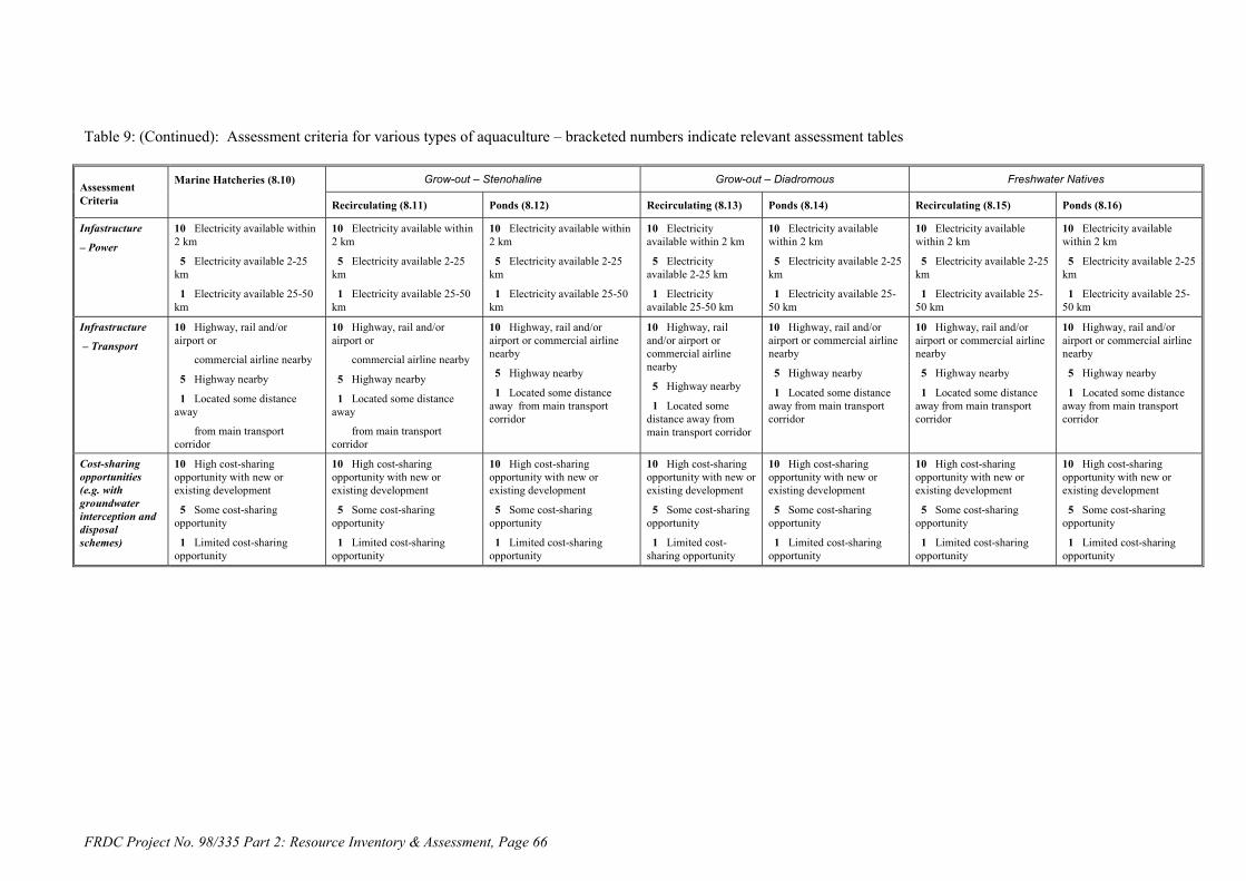
FRDC Project No. 98/335 Part 2: Resource Inventory & Assessment, Page 66
Table 9: (Continued): Assessment criteria for various types of aquaculture – bracketed numbers indicate relevant assessment tables
Grow-out – Stenohaline Grow-out – Diadromous Freshwater NativesAssessmentCriteria
Marine Hatcheries (8.10)
Recirculating (8.11) Ponds (8.12) Recirculating (8.13) Ponds (8.14) Recirculating (8.15) Ponds (8.16)
Infastructure
– Power
10 Electricity available within2 km
5 Electricity available 2-25km
1 Electricity available 25-50km
10 Electricity available within2 km
5 Electricity available 2-25km
1 Electricity available 25-50km
10 Electricity available within2 km
5 Electricity available 2-25km
1 Electricity available 25-50km
10 Electricityavailable within 2 km
5 Electricityavailable 2-25 km
1 Electricityavailable 25-50 km
10 Electricity availablewithin 2 km
5 Electricity available 2-25km
1 Electricity available 25-50 km
10 Electricity availablewithin 2 km
5 Electricity available 2-25km
1 Electricity available 25-50 km
10 Electricity availablewithin 2 km
5 Electricity available 2-25km
1 Electricity available 25-50 km
Infrastructure
– Transport
10 Highway, rail and/orairport or
commercial airline nearby
5 Highway nearby
1 Located some distanceaway
from main transportcorridor
10 Highway, rail and/orairport or
commercial airline nearby
5 Highway nearby
1 Located some distanceaway
from main transportcorridor
10 Highway, rail and/orairport or commercial airlinenearby
5 Highway nearby
1 Located some distanceaway from main transportcorridor
10 Highway, railand/or airport orcommercial airlinenearby
5 Highway nearby
1 Located somedistance away frommain transport corridor
10 Highway, rail and/orairport or commercial airlinenearby
5 Highway nearby
1 Located some distanceaway from main transportcorridor
10 Highway, rail and/orairport or commercial airlinenearby
5 Highway nearby
1 Located some distanceaway from main transportcorridor
10 Highway, rail and/orairport or commercial airlinenearby
5 Highway nearby
1 Located some distanceaway from main transportcorridor
Cost-sharingopportunities(e.g. withgroundwaterinterception anddisposalschemes)
10 High cost-sharingopportunity with new orexisting development
5 Some cost-sharingopportunity
1 Limited cost-sharingopportunity
10 High cost-sharingopportunity with new orexisting development
5 Some cost-sharingopportunity
1 Limited cost-sharingopportunity
10 High cost-sharingopportunity with new orexisting development
5 Some cost-sharingopportunity
1 Limited cost-sharingopportunity
10 High cost-sharingopportunity with new orexisting development
5 Some cost-sharingopportunity
1 Limited cost-sharing opportunity
10 High cost-sharingopportunity with new orexisting development
5 Some cost-sharingopportunity
1 Limited cost-sharingopportunity
10 High cost-sharingopportunity with new orexisting development
5 Some cost-sharingopportunity
1 Limited cost-sharingopportunity
10 High cost-sharingopportunity with new orexisting development
5 Some cost-sharingopportunity
1 Limited cost-sharingopportunity

NSW Fisheries 67
FRDC Project 98/335 – Part 2 Allan, Banens & Fielder
8.12. Saline Resource Assessment
8.12.1. General
The following represents the application of the assessment criteria developed in the previous chapter tosaline resources identified as having potential for inland saline aquaculture. This assessment has beenapplied for each of the aquaculture types.
1. Marine hatcheries (Table 10).2. Grow-out of stenohaline fish using recirculating facilities (Table 11).3. Grow-out of stenohaline fish using ponds (Table 12).4. Grow-out of diadromous fish using recirculating facilities (Table 13).5. Grow-out of diadromous fish using ponds (Table 14).6. Grow-out of freshwater native fish using recirculating facilities (Table 15).7. Grow-out of freshwater native fish using ponds (Table 16).
Each of the above tables has parts A, B, C and D representing different types of saline water resources.
8.12.2. Assessing the Suitability of Saline Resources
The results in Tables 10 to 15 represent a preliminary and indicative assessment of the suitability ofsaline water resources for various types of aquaculture. Where possible, individual criteria assessmentshave been based on quantitative or qualitative information. In many cases, however, particularly forresources other than existing salt interception schemes, an educated judgement has been made.Individual scores for each of the thirteen criteria have been summed to provide an overall assessment ofthe particular resource, and generally the higher the score the better. It is important to note that minordifferences in scores are unlikely to be significant, and it is important to refer back to the text or otherinformation sources for any comparative evaluation. Overall scores that are bracketed indicate that oneor more of the criteria could not be scored.
The weightings and assessment scores have been explicitly presented, so that individuals can undertaketheir own weighting and assessment.
Two types of assessment criteria have been used for this resource assessment namely:
General criteria that are common to each of the aquaculture types such as environmental sensitivity,infrastructure and cost-sharing.
Aquaculture-specific criteria such as resource requirement, salinity, ionic composition, landavailability and soil type.
8.12.3. Overview of Assessment Outcomes
A number of saline water resources scored highly under the majority of aquaculture types. Theseincluded:
The Esperance-Kalgoorlie seawater pipeline. Most groundwater interception schemes. Most of the Kerang Lakes. Urban groundwater pumping. The aquifers of the Murray Hydrogeological Basin. Coal mine drainage water.

68 NSW Fisheries
FRDC Project No. 98/335 Allan, Dignam, Banens & Fielder
It should be pointed out nevertheless that these findings are the result of a preliminary and indicativeassessment, tentative scoring criteria, and often with limited resources information. Other resources,such as the Western District Volcanic Lakes, may score better under different criteria or weightings, orhave qualities that make them more attractive to the establishment of saline aquaculture.
Marine hatcheries:Saline water resources that scored well in relation to marine hatcheries included most groundwaterinterception schemes and the associated aquifers of the Murray Hydrogeological Basin. However,interception schemes also involving irrigation drainage did not score as high. The Wianamatta Shale ofthe Sydney Basin was another groundwater aquifer that scored well. Other resources to score wellincluded urban groundwater pumping, coal mine drainage water, and most of the Kerang saline lakes.The proposed Esperance-Kalgoorlie seawater pipeline scored highest of all the identified resources.
Grow-out of stenohaline fish using recirculating facilities:The saline water resources that scored well for this type of aquaculture were almost identical to thoselisted for marine hatcheries.
Grow-out of stenohaline fish using ponds:Here also the saline water resources that scored well for this type of aquaculture were largely the sameas those listed for marine hatcheries.
Grow-out of diadromous fish using recirculating facilities:Likely suitable saline water resources for this aquaculture type included virtually all groundwaterinterception schemes and groundwaters, including Eyre Peninsula Region in South Australia. Urbangroundwater pumping, shallow groundwater pumping in the Ord River Irrigation Area, the Esperance-Kalgoorlie seawater pipeline, coal mine drainage water, and all the Kerang Lakes also scored highly.
Grow-out of diadromous fish using ponds:Saline resources that scored well under this category included virtually all groundwaters, all of theKerang Lakes, urban groundwater pumping, shallow groundwater pumping in the Ord River IrrigationArea, the Esperance-Kalgoorlie seawater pipeline and coal mine drainage water. Most groundwaterinterception schemes also scored highly in this category.
Grow-out of freshwater native fish using recirculating facilities:Resources to score well in this aquaculture category included groundwater interception schemes,particularly those that are more brackish or include more dilute irrigation drainage water. Urbangroundwater pumping, shallow groundwater pumping in the Ord River Irrigation Area, the Esperance-Karoorlie seawater pipeline, a few of the Kerang Lakes and significant number of the groundwaterresources also scored fairly high. Coal mine drainage water scored the highest for this category.
Grow-out of freshwater native fish using ponds:The brackish water requirements of freshwater native fish meant that only a couple of groundwaterinterception schemes scored highly. However, urban groundwater pumping, groundwater pumping inthe Ord Irrigation Area, coal mine drainage, the proposed Esperance-Karoorlie seawater pipeline, and acouple of the fresher Kerang lakes scored well for this category. Most groundwater resources alsoscored comparatively well for this aquaculture type.

FRDC Project No. 98/335 Part 2: Resource Inventory & Assessment, Page 69
Table 10: Ranking of Identified Saline Water Resource Interception and or Disposal Schemes for Marine Hatcheries (A)
Saline water resource and nearest
major location
Resource
availability
(10, 5, 1)
Resource
salinity
(10, 5, 1)
Ionic makeup
(10, 5, 1)
Other water
quality
(3, 2, 1)
Freshwater
availability
(10, 5, 0)
Land
availability
(10, 5, 0)
Soil type (10,
5, 0)
Environ-
mental
sensitivity (3,
2, 1)
Existing
structures
(10, 5, 3, 1)
Labour &
services
availability
(3, 2, 1)
Electricity
supply
proximity
(10, 5, 1)
Transport
proximity
(10, 5, 1)
Cost sharing
opportunity
(10, 5, 1)
Overall score
(max 109)
Woolpunda Goundwater Interception Scheme -
Stockyard Plain Basin, Waikerie, SA
10 5 10 3 10 10 10 2 10 3 5 5 5 88
Waikerie Salt Interception Scheme - Stockyard
Plain Basin, Waikerie, SA
10 1 10 3 10 10 10 2 10 3 5 5 5 84
Noora Drainage Diversion Scheme, Berri /
Loxton, SA
5 1 na 2 5 10 10 2 10 3 5 5 5 (63)
Rufus River Goundwater Interception Scheme,
Lake Victoria, NSW
10 10 na 3 5 10 10 3 10 1 5 1 5 (73)
Mildura-Merbein Goundwater Interception
Scheme, Mildura, Vic
10 5 10 3 10 10 10 3 10 3 5 10 5 94
Buronga Salt Interception Scheme, Mildura, Vic 10 5 10 3 5 10 10 3 10 2 5 10 5 88
Mallee Cliffs Salt Interception Scheme, Mildura,
Vic
10 10 10 3 10 10 10 2 10 2 5 10 5 97
Wakool Salinity Control Scheme, Wakool, NSW 10 1 5 2 10 10 10 3 10 2 10 1 10 84
Barr Creek Salinity Control Scheme, Kerang, Vic 10 1 na 2 10 10 10 1 10 3 10 5 5 (77)
Girgarre Basin Salinity Control Project, Stanhope,
Vic
10 1 5 2 5 10 10 3 10 2 10 1 5 74
Pyramid Hill Groundwater Interception &Salt
Harvesting Scheme, Kerang, Vic (private)
10 5 5 2 10 10 10 3 5 2 10 5 ? (77)

FRDC Project No. 98/335 Part 2: Resource Inventory & Assessment, Page 70
Table.10B: Ranking of proposed groundwater disposal schemes and other potential saline water resources for marine hatcheries
Saline water resource and nearestmajor location
Resource
availability
(10, 5, 1)
Resource
salinity
(10, 5, 1)
Ionic
makeup
(10, 5, 1)
Other water
quality
(3, 2, 1)
Freshwater
availability
(10, 5, 0)
Land
availability
(10, 5, 0)
Soil type (10,
5, 0)
Environ-
mental
sensitivity (3,
2, 1)
Existing
structures
(10, 5, 3, 0)
Labour &
services
availability
(3, 2, 1)
Electricity
supply
proximity
(10, 5, 1)
Transport
proximity
(10, 5, 1)
Cost sharing
opportunity
(10, 5, 1)
Overall score
(max 109)
Qualco-Sunlands Groundwater Interception & Salinity
Control Scheme /Stockyard Basin, Waikerie, SA
10 5 10 2 10 10 10 2 5 3 5 5 10 87
Waikerie Stage II Salt Interception Scheme /
Stockyard Basin, Waikerie, SA
10 5 10 3 10 10 10 2 5 3 5 5 10 88
Pyramid Creek Groundwater Interception
Scheme, Kerang, Vic
10 5 5 3 10 10 10 3 3 3 5 5 10 82
Lindsay River Groundwater Interception Scheme,
Mildura, Vic
10 5 5 3 5 10 10 1 3 1 5 1 10 69
Chowilla Groundwater Interception Scheme,
Renmark, SA
10 10 5 3 5 10 10 1 3 3 5 5 10 80
Bookpurnong-Loxton Groundwater Interception
& Drainage Scheme / Noora Basin, Berri /
Loxton, SA
10 5 1 2 5 10 10 2 3 3 5 5 10 71
North Pike-Murtho Salt Interception Scheme,
Paringa, SA
10 1 5 3 10 10 10 3 0 3 5 5 10 75
Yanda Creek Groundwater Interception Scheme,
Louth (Darling River), NSW
10 1 1 3 5 10 10 2 0 1 1 1 10 55
Urban groundwater pumping schemes– various in
MDB and WA e.g. Wagga, NSW
10 1 1 1 10 10 10 3 3 3 10 10 10 82
Ord River Irrigation Area groundwater pumping
schemes, Kununurra, WA
10 1 1 2 10 10 10 3 3 2 5 5 10 72
Esperance-Kalgoorlie seawater pipeline,
Esperance and Kalgoorlie, WA
10 10 10 3 10 10 10 3 3 3 10 10 10 102
On-farm Serial Biological-Concentration projects,
Murray-Darling Basin and WA
5 1 1 2 0 10 10 3 0 1 5 1 10 49
Coal mine drainage water – various NSW and
QLD
10 1 1 1 10 10 10 3 5 3 10 10 10 84

FRDC Project No. 98/335 Part 2: Resource Inventory & Assessment, Page 71
Table 10C: Ranking of Victorian permanent saline lakes for marine hatcheries
Saline water resource and nearestmajor location
Resource
availability
(10, 5, 1)
Resource
salinity
(10, 5, 1)
Ionic
makeup
(10, 5, 1)
Other water
quality
(3, 2, 1)
Freshwater
availability
(10, 5, 0)
Land
availability
(10, 5, 0)
Soil type (10,
5, 0)
Environ-
mental
sensitivity (3,
2, 1)
Existing
structures
(10, 5, 3, 0)
Labour &
services
availability
(3, 2, 1)
Electricity
supply
proximity
(10, 5, 1)
Transport
proximity
(10, 5, 1)
Cost sharing
opportunity
(10, 5, 1)
Overall score
(max 109)
Lake Corangamite, Colac, Vic 10 5 5 2 5 10 10 1 0 3 10 5 1 67
Lake Bullen Merri, Colac, Vic 10 1 5 2 5 10 10 2 0 3 10 5 1 64
Lake Purrumbete, Colac, Vic 10 1 5 2 5 10 10 2 0 3 10 5 1 64
Lake Martin, Colac, Vic 10 1 5 2 5 10 10 1 0 3 10 5 1 63
Lake Gnarpurt, Colac, Vic 10 1 5 2 5 10 10 1 0 3 10 5 1 63
Lake Colac, Colac, Vic 10 1 5 2 5 10 10 2 0 3 10 5 1 64
Lake Gnotuk, Colac, Vic 10 1 5 2 5 10 10 1 0 3 10 5 1 63
Lake Colongulac, Colac, Vic 10 1 5 2 5 10 10 1 0 3 10 5 1 63
East Basin Lake, Colac, Vic 10 na na 2 5 10 10 1 0 3 10 5 1 (57)
West Basin Lake, Colac, Vic 10 na na 2 5 10 10 1 0 3 10 5 1 (57)
Lake Tutchewop, Kerang, Vic 10 1 na 2 10 10 10 1 5 3 10 10 10 (82)
Cullens Lake, Kerang, Vic 10 1 na 2 10 10 10 1 5 3 10 10 5 (77)
Lake Kelly, Kerang, Vic 10 5 na 2 10 10 10 1 5 3 10 10 10 (86)
Lake William, Kerang, Vic 10 1 na 2 10 10 10 1 5 3 10 10 10 (82)
Lake Elizabeth, Kerang, Vic 10 5 na 2 10 10 10 2 5 3 10 10 5 (82)
Lake Wandella, Kerang, Vic 10 10 na 2 10 10 10 2 5 3 10 10 5 (87)
Little Lake Kelly, Kerang, Vic 10 5 na 2 10 10 10 2 5 3 10 10 10 (87)
Lake Charm, Kerang, Victoria 10 1 na 2 10 10 10 1 5 3 10 10 10 (82)
Lookout Lake, Kerang, Vic 10 1 na 2 10 10 10 2 5 3 10 10 5 (78)
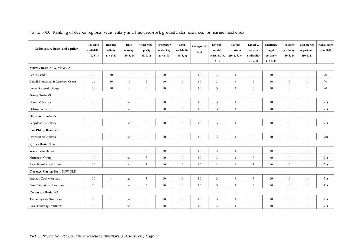
FRDC Project No. 98/335 Part 2: Resource Inventory & Assessment, Page 72
Table 10D: Ranking of deeper regional sedimentary and fractured-rock groundwater resources for marine hatcheries
Sedimentary basin and aquiferResource
availability
(10, 5, 1)
Resource
salinity
(10, 5, 1)
Ionic
makeup
(10, 5, 1)
Other water
quality
(3, 2, 1)
Freshwater
availability
(10, 5, 0)
Land
availability
(10, 5, 0)
Soil type (10,
5, 0)
Environ-
mental
sensitivity (3,
2, 1)
Existing
structures
(10, 5, 3, 0)
Labour &
services
availability
(3, 2, 1)
Electricity
supply
proximity
(10, 5, 1)
Transport
proximity
(10, 5, 1)
Cost sharing
opportunity
(10, 5, 1)
Overall score
(max 109)
Murray Basin NSW, Vic & SA
Parilla Sands 10 10 10 3 10 10 10 3 0 3 10 10 1 90
Calivil Fromation & Renmark Group 10 10 10 3 10 10 10 3 0 3 10 10 1 90
Lower Renmark Group 10 10 10 3 10 10 10 3 0 3 10 10 1 90
Otway Basin Vic
Newer Volcanics 10 1 na 3 10 10 10 3 0 3 10 10 1 (71)
Dylwin Formation 10 1 na 3 10 10 10 3 0 3 10 10 1 (71)
Gippsland Basin Vic
Gippsland Limestone 10 1 na 3 10 10 10 3 0 3 10 10 1 (71)
Port Phillip Basin Vic
Unspecified aquifers 10 1 na 2 10 10 10 3 0 3 10 10 1 (70)
Sydney Basin NSW
Wianamatta Shales 10 1 10 3 10 10 10 3 0 3 10 10 1 81
Narrabeen Group 10 1 na 3 10 10 10 3 0 3 10 10 1 (71)
Basal Permian sediments 10 1 na 3 10 10 10 3 0 3 10 10 1 (71)
Clarence-Morton Basin NSW-QLD
Walloon Coal Measures 10 1 na 3 10 10 10 3 0 3 10 10 1 (71)
Basal Triassic coal measures 10 1 na 3 10 10 10 3 0 3 10 10 1 (71)
Carnarvon Basin WA
Tumbalagooda Sandstone 10 1 na 3 10 10 10 3 0 3 10 10 1 (71)
Basal Birdrong Sandstone 10 1 na 3 10 10 10 3 0 3 10 10 1 (71)
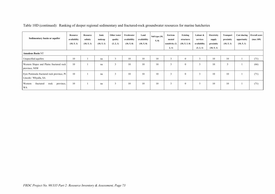
FRDC Project No. 98/335 Part 2: Resource Inventory & Assessment, Page 73
Table 10D (continued): Ranking of deeper regional sedimentary and fractured-rock groundwater resources for marine hatcheries
Sedimentary basin or aquiferResource
availability
(10, 5, 1)
Resource
salinity
(10, 5, 1)
Ionic
makeup
(10, 5, 1)
Other water
quality
(3, 2, 1)
Freshwater
availability
(10, 5, 0)
Land
availability
(10, 5, 0)
Soil type (10,
5, 0)
Environ-
mental
sensitivity (3,
2, 1)
Existing
structures
(10, 5, 3, 0)
Labour &
services
availability
(3, 2, 1)
Electricity
supply
proximity
(10, 5, 1)
Transport
proximity
(10, 5, 1)
Cost sharing
opportunity
(10, 5, 1)
Overall score
(max 109)
Amadeus Basin NT
Unspecified aquifers 10 1 na 3 10 10 10 3 0 3 10 10 1 (71)
Western Slopes and Plains fractured rockprovince, NSW
10 1 na 3 10 10 10 3 0 3 10 5 1 (66)
Eyre Peninsula fractured rock province, PtLincoln / Whyalla, SA
10 1 na 3 10 10 10 3 0 3 10 10 1 (71)
Western fractured rock province,WA
10 1 na 3 10 10 10 3 0 3 10 10 1 (71)

FRDC Project No. 98/335 Part 2: Resource Inventory & Assessment, Page 74
Table 11: Ranking of Saline Water Resource Interception and Disposal Schemes for Grow-Out of Stenohaline Fish Based on Recirculation (A)
Saline water resource and nearest
major location
Resource
availability
(10, 5, 1)
Resource
salinity
(10, 5, 1)
Ionic makeup
(10, 5, 1)
Other water
quality
(3, 2, 1)
Freshwater
availability
(10, 5, 0)
Land
availability
(10, 5, 0)
Soil type (10,
5, 0)
Environ-
mental
sensitivity (3,
2, 1)
Existing
structures
(10, 5, 3, 1)
Labour &
services
availability
(3, 2, 1)
Electricity
supply
proximity
(10, 5, 1)
Transport
proximity
(10, 5, 1)
Cost sharing
opportunity
(10, 5, 1)
Overall score
(max 109)
Woolpunda Goundwater Interception Scheme -
Stockyard Plain Basin, Waikerie, SA
10 5 10 3 10 10 10 2 10 3 5 5 5 88
Waikerie Salt Interception Scheme - Stockyard
Plain Basin, Waikerie, SA
10 1 10 3 10 10 10 2 10 3 5 5 5 84
Noora Drainage Diversion Scheme, Berri /
Loxton, SA
5 1 na 2 5 10 10 2 10 3 5 5 5 (63)
Rufus River Goundwater Interception Scheme,
Lake Victoria, NSW
10 10 na 3 5 10 10 3 10 1 5 1 5 (73)
Mildura-Merbein Goundwater Interception
Scheme, Mildura, Vic
10 5 10 3 10 10 10 3 10 3 5 10 5 94
Buronga Salt Interception Scheme, Mildura, Vic 10 5 10 3 5 10 10 3 10 2 5 10 5 88
Mallee Cliffs Salt Interception Scheme, Mildura,
Vic
10 10 10 3 10 10 10 2 10 2 5 10 5 97
Wakool Salinity Control Scheme, Wakool, NSW 10 1 5 2 10 10 10 3 10 2 10 1 10 84
Barr Creek Salinity Control Scheme, Kerang, Vic 10 1 na 2 10 10 10 1 10 3 10 5 5 (77)
Girgarre Basin Salinity Control Project, Stanhope,
Vic
10 1 5 2 5 10 10 3 10 2 10 1 5 74
Pyramid Hill Groundwater Interception &Salt
Harvesting Scheme, Kerang, Vic (private)
10 5 5 2 10 10 10 3 5 2 10 5 ? (77)

FRDC Project No. 98/335 Part 2: Resource Inventory & Assessment, Page 75
Table 11B: Ranking of proposed groundwater disposal schemes and potential resources for grow-out of stenohaline fish based on recirculation
Saline water resource and nearestmajor location
Resource
availability
(10, 5, 1)
Resource
salinity
(10, 5, 1)
Ionic
makeup
(10, 5, 1)
Other water
quality
(3, 2, 1)
Freshwater
availability
(10, 5, 0)
Land
availability
(10, 5, 0)
Soil type (10,
5, 0)
Environ-
mental
sensitivity (3,
2, 1)
Existing
structures
(10, 5, 3, 0)
Labour &
services
availability
(3, 2, 1)
Electricity
supply
proximity
(10, 5, 1)
Transport
proximity
(10, 5, 1)
Cost sharing
opportunity
(10, 5, 1)
Overall score
(max 109)
Qualco-Sunlands Groundwater Interception & Salinity
Control Scheme /Stockyard Basin, Waikerie, SA
10 5 10 2 10 10 10 2 5 3 5 5 10 87
Waikerie Stage II Salt Interception Scheme /
Stockyard Basin, Waikerie, SA
10 5 10 3 10 10 10 2 5 3 5 5 10 88
Pyramid Creek Groundwater Interception
Scheme, Kerang, Vic
10 5 5 3 10 10 10 3 3 3 5 5 10 82
Lindsay River Groundwater Interception Scheme,
Mildura, Vic
10 5 5 3 5 10 10 1 3 1 5 1 10 69
Chowilla Groundwater Interception Scheme,
Renmark, SA
10 10 5 3 5 10 10 1 3 3 5 5 10 80
Bookpurnong-Loxton Groundwater Interception
& Drainage Scheme / Noora Basin, Berri /
Loxton, SA
10 5 1 2 5 10 10 2 3 3 5 5 10 71
North Pike-Murtho Salt Interception Scheme,
Paringa, SA
10 1 5 3 10 10 10 3 0 3 5 5 10 75
Yanda Creek Groundwater Interception Scheme,
Louth (Darling River), NSW
10 1 1 3 5 10 10 2 0 1 1 1 10 55
Urban groundwater pumping schemes– various in
MDB and WA e.g. Wagga, NSW
10 1 1 1 10 10 10 3 3 3 10 10 10 82
Ord River Irrigation Area groundwater pumping
schemes, Kununurra, WA
10 1 1 2 10 10 10 3 3 2 5 5 10 72
Esperance-Kalgoorlie seawater pipeline,
Esperance and Kalgoorlie, WA
10 10 10 3 10 10 10 3 3 3 10 10 10 102
On-farm Serial Biological-Concentration projects,
Murray-Darling Basin and WA
5 1 1 2 0 10 10 3 0 1 5 1 10 49
Coal mine drainage water – various NSW and
QLD
10 1 1 1 10 10 10 3 5 3 10 10 10 84

FRDC Project No. 98/335 Part 2: Resource Inventory & Assessment, Page 76
Table 11C: Ranking of Victorian permanent saline lakes for grow-out of stenohaline fish based on recirculating facilites
Saline water resource and nearestmajor location
Resource
availability
(10, 5, 1)
Resource
salinity
(10, 5, 1)
Ionic
makeup
(10, 5, 1)
Other water
quality
(3, 2, 1)
Freshwater
availability
(10, 5, 0)
Land
availability
(10, 5, 0)
Soil type (10,
5, 0)
Environ-
mental
sensitivity (3,
2, 1)
Existing
structures
(10, 5, 3, 0)
Labour &
services
availability
(3, 2, 1)
Electricity
supply
proximity
(10, 5, 1)
Transport
proximity
(10, 5, 1)
Cost sharing
opportunity
(10, 5, 1)
Overall score
(max 109)
Lake Corangamite, Colac, Vic 10 5 5 2 5 10 10 1 0 3 10 5 1 67
Lake Bullen Merri, Colac, Vic 10 1 5 2 5 10 10 2 0 3 10 5 1 64
Lake Purrumbete, Colac, Vic 10 1 5 2 5 10 10 2 0 3 10 5 1 64
Lake Martin, Colac, Vic 10 1 5 2 5 10 10 1 0 3 10 5 1 63
Lake Gnarpurt, Colac, Vic 10 1 5 2 5 10 10 1 0 3 10 5 1 63
Lake Colac, Colac, Vic 10 1 5 2 5 10 10 2 0 3 10 5 1 64
Lake Gnotuk, Colac, Vic 10 1 5 2 5 10 10 1 0 3 10 5 1 63
Lake Colongulac, Colac, Vic 10 1 5 2 5 10 10 1 0 3 10 5 1 63
East Basin Lake, Colac, Vic 10 na na 2 5 10 10 1 0 3 10 5 1 (57)
West Basin Lake, Colac, Vic 10 na na 2 5 10 10 1 0 3 10 5 1 (57)
Lake Tutchewop, Kerang, Vic 10 1 na 2 10 10 10 1 5 3 10 10 10 (82)
Cullens Lake, Kerang, Vic 10 1 na 2 10 10 10 1 5 3 10 10 5 (77)
Lake Kelly, Kerang, Vic 10 5 na 2 10 10 10 1 5 3 10 10 10 (86)
Lake William, Kerang, Vic 10 1 na 2 10 10 10 1 5 3 10 10 10 (82)
Lake Elizabeth, Kerang, Vic 10 5 na 2 10 10 10 2 5 3 10 10 5 (82)
Lake Wandella, Kerang, Vic 10 10 na 2 10 10 10 2 5 3 10 10 5 (87)
Little Lake Kelly, Kerang, Vic 10 5 na 2 10 10 10 2 5 3 10 10 10 (87)
Lake Charm, Kerang, Victoria 10 1 na 2 10 10 10 1 5 3 10 10 10 (82)
Lookout Lake, Kerang, Vic 10 1 na 2 10 10 10 2 5 3 10 10 5 (78)

FRDC Project No. 98/335 Part 2: Resource Inventory & Assessment, Page 77
Table 11D: Ranking of regional sedimentary and fractured-rock groundwaters for grow-out of stenohaline fish based on recirculating facilities
Sedimentary basin and aquiferResource
availability
(10, 5, 1)
Resource
salinity
(10, 5, 1)
Ionic
makeup
(10, 5, 1)
Other water
quality
(3, 2, 1)
Freshwater
availability
(10, 5, 0)
Land
availability
(10, 5, 0)
Soil type (10,
5, 0)
Environ-
mental
sensitivity (3,
2, 1)
Existing
structures
(10, 5, 3, 0)
Labour &
services
availability
(3, 2, 1)
Electricity
supply
proximity
(10, 5, 1)
Transport
proximity
(10, 5, 1)
Cost sharing
opportunity
(10, 5, 1)
Overall score
(max 109)
Murray Basin NSW, Vic & SA
Parilla Sands 10 10 10 3 10 10 10 3 0 3 10 10 1 90
Calivil Fromation & Renmark Group 10 10 10 3 10 10 10 3 0 3 10 10 1 90
Lower Renmark Group 10 10 10 3 10 10 10 3 0 3 10 10 1 90
Otway Basin Vic
Newer Volcanics 10 1 na 3 10 10 10 3 0 3 10 10 1 (71)
Dylwin Formation 10 1 na 3 10 10 10 3 0 3 10 10 1 (71)
Gippsland Basin Vic
Gippsland Limestone 10 1 na 3 10 10 10 3 0 3 10 10 1 (71)
Port Phillip Basin Vic
Unspecified aquifers 10 1 na 2 10 10 10 3 0 3 10 10 1 (70)
Sydney Basin NSW
Wianamatta Shales 10 1 10 3 10 10 10 3 0 3 10 10 1 81
Narrabeen Group 10 1 na 3 10 10 10 3 0 3 10 10 1 (71)
Basal Permian sediments 10 1 na 3 10 10 10 3 0 3 10 10 1 (71)
Clarence-Morton Basin NSW-QLD
Walloon Coal Measures 10 1 na 3 10 10 10 3 0 3 10 10 1 (71)
Basal Triassic coal measures 10 1 na 3 10 10 10 3 0 3 10 10 1 (71)
Carnarvon Basin WA
Tumbalagooda Sandstone 10 1 na 3 10 10 10 3 0 3 10 10 1 (71)
Basal Birdrong Sandstone 10 1 na 3 10 10 10 3 0 3 10 10 1 (71)

FRDC Project No. 98/335 Part 2: Resource Inventory & Assessment, Page 78
Table 11D (continued): Ranking of regional sedimentary and fractured-rock groundwaters for grow-out of stenohaline fish based on recirculating facilities
Sedimentary basin or aquiferResource
availability
(10, 5, 1)
Resource
salinity
(10, 5, 1)
Ionic
makeup
(10, 5, 1)
Other water
quality
(3, 2, 1)
Freshwater
availability
(10, 5, 0)
Land
availability
(10, 5, 0)
Soil type (10,
5, 0)
Environ-
mental
sensitivity (3,
2, 1)
Existing
structures
(10, 5, 3, 0)
Labour &
services
availability
(3, 2, 1)
Electricity
supply
proximity
(10, 5, 1)
Transport
proximity
(10, 5, 1)
Cost sharing
opportunity
(10, 5, 1)
Overall score
(max 109)
Amadeus Basin NT
Unspecified aquifers 10 1 na 3 10 10 10 3 0 3 10 10 1 (71)
Western Slopes and Plains fractured rockprovince, NSW
10 1 na 3 10 10 10 3 0 3 10 5 1 (66)
Eyre Peninsula fractured rock province, PtLincoln / Whyalla, SA
10 1 na 3 10 10 10 3 0 3 10 10 1 (71)
Western fractured rock province,WA
10 1 na 3 10 10 10 3 0 3 10 10 1 (71)

FRDC Project No. 98/335 Part 2: Resource Inventory & Assessment, Page 79
Table 12: Ranking of Identified Saline Water Resource Interception and or Disposal Schemes for Grow-Out of Stenohaline Fish Using Ponds (A)
Saline water resource and nearest
major location
Resource
availability
(10, 5, 1)
Resource
salinity
(10, 5, 1)
Ionic makeup
(10, 5, 1)
Other water
quality
(3, 2, 1)
Freshwater
availability
(10, 5, 0)
Land
availability
(10, 5, 0)
Soil type (10,
5, 0)
Environ-
mental
sensitivity (3,
2, 1)
Existing
structures
(10, 5, 3, 1)
Labour &
services
availability
(3, 2, 1)
Electricity
supply
proximity
(10, 5, 1)
Transport
proximity
(10, 5, 1)
Cost sharing
opportunity
(10, 5, 1)
Overall score
(max 109)
Woolpunda Goundwater Interception Scheme -
Stockyard Plain Basin, Waikerie, SA
10 5 10 3 10 10 5 2 10 3 5 5 5 83
Waikerie Salt Interception Scheme - Stockyard
Plain Basin, Waikerie, SA
10 1 10 3 10 10 5 2 10 3 5 5 5 79
Noora Drainage Diversion Scheme, Berri /
Loxton, SA
5 1 na 2 5 10 5 2 10 3 5 5 5 (58)
Rufus River Goundwater Interception Scheme,
Lake Victoria, NSW
10 10 na 3 5 10 5 3 10 1 5 1 5 (68)
Mildura-Merbein Goundwater Interception
Scheme, Mildura, Vic
10 5 10 3 10 10 5 3 10 3 5 10 5 89
Buronga Salt Interception Scheme, Mildura, Vic 10 5 10 3 5 10 5 3 10 2 5 10 5 83
Mallee Cliffs Salt Interception Scheme, Mildura,
Vic
10 10 10 3 10 10 5 2 10 2 5 10 5 92
Wakool Salinity Control Scheme, Wakool, NSW 10 1 5 2 10 10 5 3 10 2 10 1 10 79
Barr Creek Salinity Control Scheme, Kerang, Vic 10 1 na 2 10 10 5 1 10 3 10 5 5 (72)
Girgarre Basin Salinity Control Project, Stanhope,
Vic
10 1 5 2 5 10 5 3 10 2 10 1 5 69
Pyramid Hill Groundwater Interception &Salt
Harvesting Scheme, Kerang, Vic (private)
1 5 5 2 10 5 0 3 5 2 10 5 ? (53)

FRDC Project No. 98/335 Part 2: Resource Inventory & Assessment, Page 80
Table 12B: Ranking of proposed groundwater disposal schemes and potential saline water resources for grow-out of stenohaline fish using ponds
Saline water resource and nearestmajor location
Resource
availability
(10, 5, 1)
Resource
salinity
(10, 5, 1)
Ionic
makeup
(10, 5, 1)
Other water
quality
(3, 2, 1)
Freshwater
availability
(10, 5, 0)
Land
availability
(10, 5, 0)
Soil type (10,
5, 0)
Environ-
mental
sensitivity (3,
2, 1)
Existing
structures
(10, 5, 3, 0)
Labour &
services
availability
(3, 2, 1)
Electricity
supply
proximity
(10, 5, 1)
Transport
proximity
(10, 5, 1)
Cost sharing
opportunity
(10, 5, 1)
Overall score
(max 109)
Qualco-Sunlands Groundwater Interception & Salinity
Control Scheme /Stockyard Basin, Waikerie, SA
10 5 10 2 10 10 10 2 5 3 5 5 10 87
Waikerie Stage II Salt Interception Scheme /
Stockyard Basin, Waikerie, SA
10 5 10 3 10 10 10 2 5 3 5 5 10 88
Pyramid Creek Groundwater Interception
Scheme, Kerang, Vic
10 5 5 3 10 10 10 3 3 3 5 5 10 82
Lindsay River Groundwater Interception Scheme,
Mildura, Vic
10 5 5 3 5 10 10 1 3 1 5 1 10 69
Chowilla Groundwater Interception Scheme,
Renmark, SA
10 10 5 3 5 10 10 1 3 3 5 5 10 80
Bookpurnong-Loxton Groundwater Interception
& Drainage Scheme / Noora Basin, Berri /
Loxton, SA
10 5 1 2 5 10 10 2 3 3 5 5 10 71
North Pike-Murtho Salt Interception Scheme,
Paringa, SA
10 1 5 3 10 10 10 3 0 3 5 5 10 75
Yanda Creek Groundwater Interception Scheme,
Louth (Darling River), NSW
10 1 1 3 5 10 10 2 0 1 1 1 10 55
Urban groundwater pumping schemes– various in
MDB and WA e.g. Wagga, NSW
5 1 1 1 10 10 10 3 3 3 10 10 10 77
Ord River Irrigation Area groundwater pumping
schemes, Kununurra, WA
10 1 1 2 10 10 10 3 3 2 5 5 10 72
Esperance-Kalgoorlie seawater pipeline,
Esperance and Kalgoorlie, WA
10 10 10 3 10 10 10 3 3 3 10 10 10 102
On-farm Serial Biological-Concentration projects,
Murray-Darling Basin and WA
1 1 1 2 0 5 10 3 0 1 5 1 10 40
Coal mine drainage water – various NSW and
QLD
10 1 1 1 10 10 10 3 5 3 10 10 10 84

FRDC Project No. 98/335 Part 2: Resource Inventory & Assessment, Page 81
Table 12C: Ranking of Victorian permanent saline lakes for grow-out of stenohaline fish using ponds
Saline water resource and nearestmajor location
Resource
availability
(10, 5, 1)
Resource
salinity
(10, 5, 1)
Ionic
makeup
(10, 5, 1)
Other water
quality
(3, 2, 1)
Freshwater
availability
(10, 5, 0)
Land
availability
(10, 5, 0)
Soil type (10,
5, 0)
Environ-
mental
sensitivity (3,
2, 1)
Existing
structures
(10, 5, 3, 0)
Labour &
services
availability
(3, 2, 1)
Electricity
supply
proximity
(10, 5, 1)
Transport
proximity
(10, 5, 1)
Cost sharing
opportunity
(10, 5, 1)
Overall score
(max 109)
Lake Corangamite, Colac, Vic 10 5 5 2 5 10 10 1 0 3 10 5 1 67
Lake Bullen Merri, Colac, Vic 10 1 5 2 5 10 10 2 0 3 10 5 1 64
Lake Purrumbete, Colac, Vic 10 1 5 2 5 10 10 2 0 3 10 5 1 64
Lake Martin, Colac, Vic 10 1 5 2 5 10 10 1 0 3 10 5 1 63
Lake Gnarpurt, Colac, Vic 10 1 5 2 5 10 10 1 0 3 10 5 1 63
Lake Colac, Colac, Vic 10 1 5 2 5 10 10 2 0 3 10 5 1 64
Lake Gnotuk, Colac, Vic 10 1 5 2 5 10 10 1 0 3 10 5 1 63
Lake Colongulac, Colac, Vic 10 1 5 2 5 10 10 1 0 3 10 5 1 63
East Basin Lake, Colac, Vic 10 na na 2 5 10 10 1 0 3 10 5 1 (57)
West Basin Lake, Colac, Vic 10 na na 2 5 10 10 1 0 3 10 5 1 (57)
Lake Tutchewop, Kerang, Vic 10 1 na 2 10 10 10 1 5 3 10 10 10 (82)
Cullens Lake, Kerang, Vic 10 1 na 2 10 10 10 1 5 3 10 10 5 (77)
Lake Kelly, Kerang, Vic 10 5 na 2 10 10 10 1 5 3 10 10 10 (86)
Lake William, Kerang, Vic 10 1 na 2 10 10 10 1 5 3 10 10 10 (82)
Lake Elizabeth, Kerang, Vic 10 5 na 2 10 10 10 2 5 3 10 10 5 (82)
Lake Wandella, Kerang, Vic 10 10 na 2 10 10 10 2 5 3 10 10 5 (87)
Little Lake Kelly, Kerang, Vic 10 5 na 2 10 10 10 2 5 3 10 10 10 (87)
Lake Charm, Kerang, Victoria 10 1 na 2 10 10 10 1 5 3 10 10 10 (82)
Lookout Lake, Kerang, Vic 10 1 na 2 10 10 10 2 5 3 10 10 5 (78)

FRDC Project No. 98/335 Part 2: Resource Inventory & Assessment, Page 82
Table 12D: Ranking of deeper regional sedimentary and fractured-rock groundwater resources for grow-out of stenohaline fish using ponds
Sedimentary basin and aquiferResource
availability
(10, 5, 1)
Resource
salinity
(10, 5, 1)
Ionic
makeup
(10, 5, 1)
Other water
quality
(3, 2, 1)
Freshwater
availability
(10, 5, 0)
Land
availability
(10, 5, 0)
Soil type (10,
5, 0)
Environ-
mental
sensitivity (3,
2, 1)
Existing
structures
(10, 5, 3, 0)
Labour &
services
availability
(3, 2, 1)
Electricity
supply
proximity
(10, 5, 1)
Transport
proximity
(10, 5, 1)
Cost sharing
opportunity
(10, 5, 1)
Overall score
(max 109)
Murray Basin NSW, Vic & SA
Parilla Sands 10 10 10 3 10 10 10 3 0 3 10 10 1 90
Calivil Fromation & Renmark Group 10 10 10 3 10 10 10 3 0 3 10 10 1 90
Lower Renmark Group 10 10 10 3 10 10 10 3 0 3 10 10 1 90
Otway Basin Vic
Newer Volcanics 10 1 na 3 10 10 10 3 0 3 10 10 1 (71)
Dylwin Formation 10 1 na 3 10 10 10 3 0 3 10 10 1 (71)
Gippsland Basin Vic
Gippsland Limestone 10 1 na 3 10 10 10 3 0 3 10 10 1 (71)
Port Phillip Basin Vic
Unspecified aquifers 10 1 na 2 10 10 10 3 0 3 10 10 1 (70)
Sydney Basin NSW
Wianamatta Shales 10 1 10 3 10 10 10 3 0 3 10 10 1 81
Narrabeen Group 10 1 na 3 10 10 10 3 0 3 10 10 1 (71)
Basal Permian sediments 10 1 na 3 10 10 10 3 0 3 10 10 1 (71)
Clarence-Morton Basin NSW-QLD
Walloon Coal Measures 10 1 na 3 10 10 10 3 0 3 10 10 1 (71)
Basal Triassic coal measures 10 1 na 3 10 10 10 3 0 3 10 10 1 (71)
Carnarvon Basin WA
Tumbalagooda Sandstone 10 1 na 3 10 10 10 3 0 3 10 10 1 (71)
Basal Birdrong Sandstone 10 1 na 3 10 10 10 3 0 3 10 10 1 (71)

FRDC Project No. 98/335 Part 2: Resource Inventory & Assessment, Page 83
Table 12D (continued): Ranking of deeper regional sedimentary and fractured-rock groundwater resources for grow-out of stenohaline fish using ponds
Sedimentary basin or aquiferResource
availability
(10, 5, 1)
Resource
salinity
(10, 5, 1)
Ionic
makeup
(10, 5, 1)
Other water
quality
(3, 2, 1)
Freshwater
availability
(10, 5, 0)
Land
availability
(10, 5, 0)
Soil type (10,
5, 0)
Environ-
mental
sensitivity (3,
2, 1)
Existing
structures
(10, 5, 3, 0)
Labour &
services
availability
(3, 2, 1)
Electricity
supply
proximity
(10, 5, 1)
Transport
proximity
(10, 5, 1)
Cost sharing
opportunity
(10, 5, 1)
Overall score
(max 109)
Amadeus Basin NT
Unspecified aquifers 10 1 na 3 10 10 10 3 0 3 10 10 1 (71)
Western Slopes and Plains fractured rockprovince, NSW
1 1 na 3 10 10 10 3 0 3 10 5 1 (57)
Eyre Peninsula fractured rock province, PtLincoln / Whyalla, SA
5 1 na 3 10 10 10 3 0 3 10 10 1 (66)
Western fractured rock province,WA
10 1 na 3 10 10 10 3 0 3 10 10 1 (71)

FRDC Project No. 98/335 Part 2: Resource Inventory & Assessment, Page 84
Table 13: Ranking of Identified Saline Water Resource Interception and or Disposal Schemes for Grow-Out of Diadromous Fish Using Recirculation (A)
Saline water resource and nearest
major location
Resource
availability
(10, 5, 1)
Resource
salinity
(10, 5, 1)
Ionic makeup
(10, 5, 1)
Other water
quality
(3, 2, 1)
Freshwater
availability
(10, 5, 0)
Land
availability
(10, 5, 0)
Soil type (10,
5, 0)
Environ-
mental
sensitivity (3,
2, 1)
Existing
structures
(10, 5, 3, 1)
Labour &
services
availability
(3, 2, 1)
Electricity
supply
proximity
(10, 5, 1)
Transport
proximity
(10, 5, 1)
Cost sharing
opportunity
(10, 5, 1)
Overall score
(max 109)
Woolpunda Goundwater Interception Scheme -
Stockyard Plain Basin, Waikerie, SA
10 10 10 3 10 10 10 2 10 3 5 5 5 93
Waikerie Salt Interception Scheme - Stockyard
Plain Basin, Waikerie, SA
10 10 10 3 10 10 10 2 10 3 5 5 5 93
Noora Drainage Diversion Scheme, Berri /
Loxton, SA
5 10 10 2 5 10 10 2 10 3 5 5 5 82
Rufus River Goundwater Interception Scheme,
Lake Victoria, NSW
10 10 10 3 5 10 10 3 10 1 5 1 5 83
Mildura-Merbein Goundwater Interception
Scheme, Mildura, Vic
10 1 10 3 10 10 10 3 10 3 5 10 5 90
Buronga Salt Interception Scheme, Mildura, Vic 10 10 10 3 5 10 10 3 10 2 5 10 5 93
Mallee Cliffs Salt Interception Scheme, Mildura,
Vic
10 10 10 3 10 10 10 2 10 2 5 10 5 97
Wakool Salinity Control Scheme, Wakool, NSW 10 10 10 2 10 10 10 3 10 2 10 1 10 98
Barr Creek Salinity Control Scheme, Kerang, Vic 10 10 na 2 10 10 10 1 10 3 10 5 5 (86)
Girgarre Basin Salinity Control Project, Stanhope,
Vic
10 10 10 2 5 10 10 3 10 2 10 1 5 88
Pyramid Hill Groundwater Interception &Salt
Harvesting Scheme, Kerang, Vic (private)
10 10 10 2 10 10 10 3 5 2 10 5 ? (87)
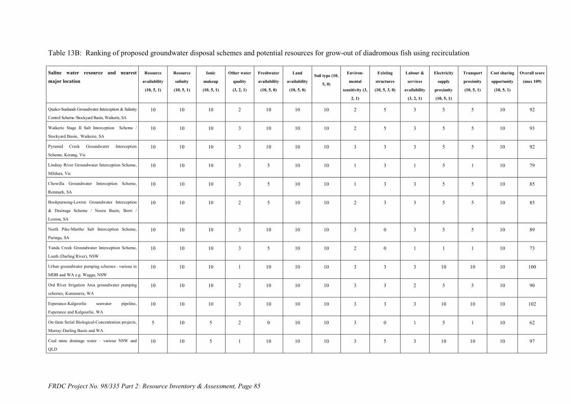
FRDC Project No. 98/335 Part 2: Resource Inventory & Assessment, Page 85
Table 13B: Ranking of proposed groundwater disposal schemes and potential resources for grow-out of diadromous fish using recirculation
Saline water resource and nearestmajor location
Resource
availability
(10, 5, 1)
Resource
salinity
(10, 5, 1)
Ionic
makeup
(10, 5, 1)
Other water
quality
(3, 2, 1)
Freshwater
availability
(10, 5, 0)
Land
availability
(10, 5, 0)
Soil type (10,
5, 0)
Environ-
mental
sensitivity (3,
2, 1)
Existing
structures
(10, 5, 3, 0)
Labour &
services
availability
(3, 2, 1)
Electricity
supply
proximity
(10, 5, 1)
Transport
proximity
(10, 5, 1)
Cost sharing
opportunity
(10, 5, 1)
Overall score
(max 109)
Qualco-Sunlands Groundwater Interception & Salinity
Control Scheme /Stockyard Basin, Waikerie, SA
10 10 10 2 10 10 10 2 5 3 5 5 10 92
Waikerie Stage II Salt Interception Scheme /
Stockyard Basin, Waikerie, SA
10 10 10 3 10 10 10 2 5 3 5 5 10 93
Pyramid Creek Groundwater Interception
Scheme, Kerang, Vic
10 10 10 3 10 10 10 3 3 3 5 5 10 92
Lindsay River Groundwater Interception Scheme,
Mildura, Vic
10 10 10 3 5 10 10 1 3 1 5 1 10 79
Chowilla Groundwater Interception Scheme,
Renmark, SA
10 10 10 3 5 10 10 1 3 3 5 5 10 85
Bookpurnong-Loxton Groundwater Interception
& Drainage Scheme / Noora Basin, Berri /
Loxton, SA
10 10 10 2 5 10 10 2 3 3 5 5 10 85
North Pike-Murtho Salt Interception Scheme,
Paringa, SA
10 10 10 3 10 10 10 3 0 3 5 5 10 89
Yanda Creek Groundwater Interception Scheme,
Louth (Darling River), NSW
10 10 10 3 5 10 10 2 0 1 1 1 10 73
Urban groundwater pumping schemes– various in
MDB and WA e.g. Wagga, NSW
10 10 10 1 10 10 10 3 3 3 10 10 10 100
Ord River Irrigation Area groundwater pumping
schemes, Kununurra, WA
10 10 10 2 10 10 10 3 3 2 5 5 10 90
Esperance-Kalgoorlie seawater pipeline,
Esperance and Kalgoorlie, WA
10 10 10 3 10 10 10 3 3 3 10 10 10 102
On-farm Serial Biological-Concentration projects,
Murray-Darling Basin and WA
5 10 5 2 0 10 10 3 0 1 5 1 10 62
Coal mine drainage water – various NSW and
QLD
10 10 5 1 10 10 10 3 5 3 10 10 10 97

FRDC Project No. 98/335 Part 2: Resource Inventory & Assessment, Page 86
Table 13C: Ranking of Victorian permanent saline lakes for grow-out of diadromous fish using recirculation
Saline water resource and nearestmajor location
Resource
availability
(10, 5, 1)
Resource
salinity
(10, 5, 1)
Ionic
makeup
(10, 5, 1)
Other water
quality
(3, 2, 1)
Freshwater
availability
(10, 5, 0)
Land
availability
(10, 5, 0)
Soil type (10,
5, 0)
Environ-
mental
sensitivity (3,
2, 1)
Existing
structures
(10, 5, 3, 0)
Labour &
services
availability
(3, 2, 1)
Electricity
supply
proximity
(10, 5, 1)
Transport
proximity
(10, 5, 1)
Cost sharing
opportunity
(10, 5, 1)
Overall score
(max 109)
Lake Corangamite, Colac, Vic 10 10 10 2 5 10 10 1 0 3 10 5 1 77
Lake Bullen Merri, Colac, Vic 10 10 10 2 5 10 10 2 0 3 10 5 1 78
Lake Purrumbete, Colac, Vic 10 10 10 2 5 10 10 2 0 3 10 5 1 78
Lake Martin, Colac, Vic 10 10 10 2 5 10 10 1 0 3 10 5 1 77
Lake Gnarpurt, Colac, Vic 10 10 10 2 5 10 10 1 0 3 10 5 1 77
Lake Colac, Colac, Vic 10 10 10 2 5 10 10 2 0 3 10 5 1 78
Lake Gnotuk, Colac, Vic 10 10 10 2 5 10 10 1 0 3 10 5 1 77
Lake Colongulac, Colac, Vic 10 10 10 2 5 10 10 1 0 3 10 5 1 77
East Basin Lake, Colac, Vic 10 na na 2 5 10 10 1 0 3 10 5 1 (57)
West Basin Lake, Colac, Vic 10 na na 2 5 10 10 1 0 3 10 5 1 (57)
Lake Tutchewop, Kerang, Vic 10 5 na 2 10 10 10 1 5 3 10 10 10 (86)
Cullens Lake, Kerang, Vic 10 10 na 2 10 10 10 1 5 3 10 10 5 (86)
Lake Kelly, Kerang, Vic 10 5 na 2 10 10 10 1 5 3 10 10 10 (86)
Lake William, Kerang, Vic 10 5 na 2 10 10 10 1 5 3 10 10 10 (86)
Lake Elizabeth, Kerang, Vic 10 10 na 2 10 10 10 2 5 3 10 10 5 (87)
Lake Wandella, Kerang, Vic 10 10 na 2 10 10 10 2 5 3 10 10 5 (87)
Little Lake Kelly, Kerang, Vic 10 5 na 2 10 10 10 2 5 3 10 10 10 (87)
Lake Charm, Kerang, Vic 10 10 na 2 10 10 10 1 5 3 10 10 10 (91)
Lookout Lake, Kerang, Vic 10 10 na 2 10 10 10 2 5 3 10 10 5 (87)
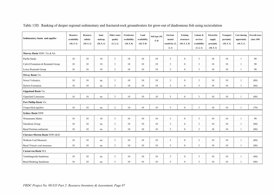
FRDC Project No. 98/335 Part 2: Resource Inventory & Assessment, Page 87
Table 13D: Ranking of deeper regional sedimentary and fractured-rock groundwaters for grow-out of diadromous fish using recirculation
Sedimentary basin and aquiferResource
availability
(10, 5, 1)
Resource
salinity
(10, 5, 1)
Ionic
makeup
(10, 5, 1)
Other water
quality
(3, 2, 1)
Freshwater
availability
(10, 5, 0)
Land
availability
(10, 5, 0)
Soil type (10,
5, 0)
Environ-
mental
sensitivity (3,
2, 1)
Existing
structures
(10, 5, 3, 0)
Labour &
services
availability
(3, 2, 1)
Electricity
supply
proximity
(10, 5, 1)
Transport
proximity
(10, 5, 1)
Cost sharing
opportunity
(10, 5, 1)
Overall score
(max 109)
Murray Basin NSW, Vic & SA
Parilla Sands 10 10 10 3 10 10 10 3 0 3 10 10 1 90
Calivil Fromation & Renmark Group 10 10 10 3 10 10 10 3 0 3 10 10 1 90
Lower Renmark Group 10 10 10 3 10 10 10 3 0 3 10 10 1 90
Otway Basin Vic
Newer Volcanics 10 10 na 3 10 10 10 3 0 3 10 10 1 (80)
Dylwin Formation 10 10 na 3 10 10 10 3 0 3 10 10 1 (80)
Gippsland Basin Vic
Gippsland Limestone 10 10 na 3 10 10 10 3 0 3 10 10 1 (80)
Port Phillip Basin Vic
Unspecified aquifers 10 10 na 2 10 10 10 3 0 3 10 10 1 (79)
Sydney Basin NSW
Wianamatta Shales 10 10 10 3 10 10 10 3 0 3 10 10 1 90
Narrabeen Group 10 10 na 3 10 10 10 3 0 3 10 10 1 (80)
Basal Permian sediments 10 10 na 3 10 10 10 3 0 3 10 10 1 (80)
Clarence-Morton Basin NSW-QLD
Walloon Coal Measures 10 10 na 3 10 10 10 3 0 3 10 10 1 (80)
Basal Triassic coal measures 10 10 na 3 10 10 10 3 0 3 10 10 1 (80)
Carnarvon Basin WA
Tumbalagooda Sandstone 10 10 na 3 10 10 10 3 0 3 10 10 1 (80)
Basal Birdrong Sandstone 10 10 na 3 10 10 10 3 0 3 10 10 1 (80)

FRDC Project No. 98/335 Part 2: Resource Inventory & Assessment, Page 88
Table 13D (continued): Ranking of deeper regional sedimentary and fractured-rock groundwaters for grow-out of diadromous fish using recirculation
Sedimentary basin or aquiferResource
availability
(10, 5, 1)
Resource
salinity
(10, 5, 1)
Ionic
makeup
(10, 5, 1)
Other water
quality
(3, 2, 1)
Freshwater
availability
(10, 5, 0)
Land
availability
(10, 5, 0)
Soil type (10,
5, 0)
Environ-
mental
sensitivity (3,
2, 1)
Existing
structures
(10, 5, 3, 0)
Labour &
services
availability
(3, 2, 1)
Electricity
supply
proximity
(10, 5, 1)
Transport
proximity
(10, 5, 1)
Cost sharing
opportunity
(10, 5, 1)
Overall score
(max 109)
Amadeus Basin NT
Unspecified aquifers 10 10 na 3 10 10 10 3 0 3 10 10 1 (80)
Western Slopes and Plains fractured rockprovince, NSW
10 10 na 3 10 10 10 3 0 3 10 5 1 (75)
Eyre Peninsula fractured rock province, PtLincoln / Whyalla, SA
10 10 na 3 10 10 10 3 0 3 10 10 1 (80)
Western fractured rock province,WA
10 1 na 3 10 10 10 3 0 3 10 10 1 (71)
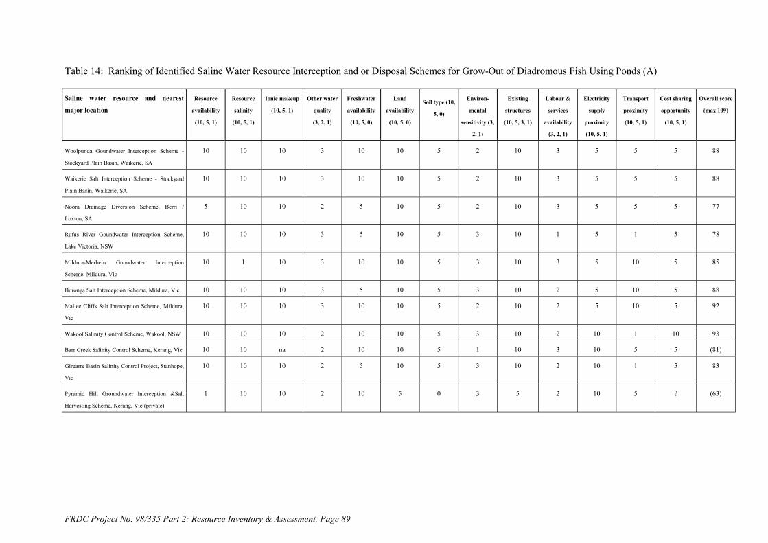
FRDC Project No. 98/335 Part 2: Resource Inventory & Assessment, Page 89
Table 14: Ranking of Identified Saline Water Resource Interception and or Disposal Schemes for Grow-Out of Diadromous Fish Using Ponds (A)
Saline water resource and nearest
major location
Resource
availability
(10, 5, 1)
Resource
salinity
(10, 5, 1)
Ionic makeup
(10, 5, 1)
Other water
quality
(3, 2, 1)
Freshwater
availability
(10, 5, 0)
Land
availability
(10, 5, 0)
Soil type (10,
5, 0)
Environ-
mental
sensitivity (3,
2, 1)
Existing
structures
(10, 5, 3, 1)
Labour &
services
availability
(3, 2, 1)
Electricity
supply
proximity
(10, 5, 1)
Transport
proximity
(10, 5, 1)
Cost sharing
opportunity
(10, 5, 1)
Overall score
(max 109)
Woolpunda Goundwater Interception Scheme -
Stockyard Plain Basin, Waikerie, SA
10 10 10 3 10 10 5 2 10 3 5 5 5 88
Waikerie Salt Interception Scheme - Stockyard
Plain Basin, Waikerie, SA
10 10 10 3 10 10 5 2 10 3 5 5 5 88
Noora Drainage Diversion Scheme, Berri /
Loxton, SA
5 10 10 2 5 10 5 2 10 3 5 5 5 77
Rufus River Goundwater Interception Scheme,
Lake Victoria, NSW
10 10 10 3 5 10 5 3 10 1 5 1 5 78
Mildura-Merbein Goundwater Interception
Scheme, Mildura, Vic
10 1 10 3 10 10 5 3 10 3 5 10 5 85
Buronga Salt Interception Scheme, Mildura, Vic 10 10 10 3 5 10 5 3 10 2 5 10 5 88
Mallee Cliffs Salt Interception Scheme, Mildura,
Vic
10 10 10 3 10 10 5 2 10 2 5 10 5 92
Wakool Salinity Control Scheme, Wakool, NSW 10 10 10 2 10 10 5 3 10 2 10 1 10 93
Barr Creek Salinity Control Scheme, Kerang, Vic 10 10 na 2 10 10 5 1 10 3 10 5 5 (81)
Girgarre Basin Salinity Control Project, Stanhope,
Vic
10 10 10 2 5 10 5 3 10 2 10 1 5 83
Pyramid Hill Groundwater Interception &Salt
Harvesting Scheme, Kerang, Vic (private)
1 10 10 2 10 5 0 3 5 2 10 5 ? (63)

FRDC Project No. 98/335 Part 2: Resource Inventory & Assessment, Page 90
Table 14B: Ranking of proposed groundwater disposal schemes and other potential resources for grow-out of diadromous fish using ponds
Saline water resource and nearestmajor location
Resource
availability
(10, 5, 1)
Resource
salinity
(10, 5, 1)
Ionic
makeup
(10, 5, 1)
Other water
quality
(3, 2, 1)
Freshwater
availability
(10, 5, 0)
Land
availability
(10, 5, 0)
Soil type (10,
5, 0)
Environ-
mental
sensitivity (3,
2, 1)
Existing
structures
(10, 5, 3, 0)
Labour &
services
availability
(3, 2, 1)
Electricity
supply
proximity
(10, 5, 1)
Transport
proximity
(10, 5, 1)
Cost sharing
opportunity
(10, 5, 1)
Overall score
(max 109)
Qualco-Sunlands Groundwater Interception & Salinity
Control Scheme /Stockyard Basin, Waikerie, SA
10 10 10 2 10 10 5 2 5 3 5 5 10 87
Waikerie Stage II Salt Interception Scheme /
Stockyard Basin, Waikerie, SA
10 10 10 3 10 10 5 2 5 3 5 5 10 88
Pyramid Creek Groundwater Interception
Scheme, Kerang, Vic
10 10 10 3 10 10 5 3 3 3 5 5 10 87
Lindsay River Groundwater Interception Scheme,
Mildura, Vic
10 10 10 3 5 10 5 1 3 1 5 1 10 74
Chowilla Groundwater Interception Scheme,
Renmark, SA
10 10 10 3 5 10 5 1 3 3 5 5 10 80
Bookpurnong-Loxton Groundwater Interception
& Drainage Scheme / Noora Basin, Berri /
Loxton, SA
10 10 10 2 5 10 5 2 3 3 5 5 10 80
North Pike-Murtho Salt Interception Scheme,
Paringa, SA
10 10 10 3 10 10 5 3 0 3 5 5 10 84
Yanda Creek Groundwater Interception Scheme,
Louth (Darling River), NSW
10 10 10 3 5 10 5 2 0 1 1 1 10 68
Urban groundwater pumping schemes– various in
MDB and WA e.g. Wagga, NSW
10 10 10 1 10 10 5 3 3 3 10 10 10 95
Ord River Irrigation Area groundwater pumping
schemes, Kununurra, WA
10 10 10 2 10 10 5 3 3 2 5 5 10 85
Esperance-Kalgoorlie seawater pipeline,
Esperance and Kalgoorlie, WA
10 10 10 3 10 10 5 3 3 3 10 10 10 97
On-farm Serial Biological-Concentration projects,
Murray-Darling Basin and WA
1 10 5 2 0 5 5 3 0 1 5 1 10 48
Coal mine drainage water – various NSW and
QLD
10 10 5 1 10 10 5 3 5 3 10 10 10 92
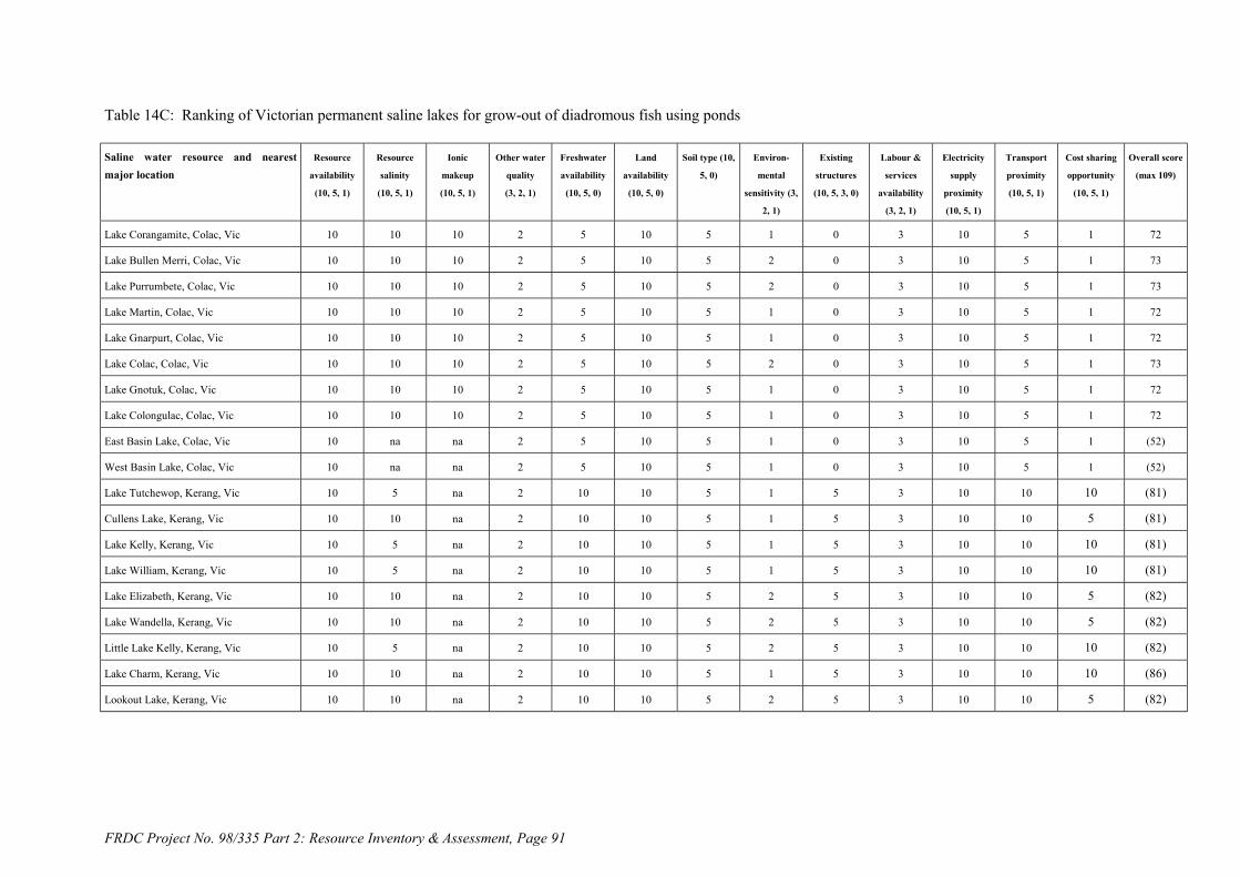
FRDC Project No. 98/335 Part 2: Resource Inventory & Assessment, Page 91
Table 14C: Ranking of Victorian permanent saline lakes for grow-out of diadromous fish using ponds
Saline water resource and nearestmajor location
Resource
availability
(10, 5, 1)
Resource
salinity
(10, 5, 1)
Ionic
makeup
(10, 5, 1)
Other water
quality
(3, 2, 1)
Freshwater
availability
(10, 5, 0)
Land
availability
(10, 5, 0)
Soil type (10,
5, 0)
Environ-
mental
sensitivity (3,
2, 1)
Existing
structures
(10, 5, 3, 0)
Labour &
services
availability
(3, 2, 1)
Electricity
supply
proximity
(10, 5, 1)
Transport
proximity
(10, 5, 1)
Cost sharing
opportunity
(10, 5, 1)
Overall score
(max 109)
Lake Corangamite, Colac, Vic 10 10 10 2 5 10 5 1 0 3 10 5 1 72
Lake Bullen Merri, Colac, Vic 10 10 10 2 5 10 5 2 0 3 10 5 1 73
Lake Purrumbete, Colac, Vic 10 10 10 2 5 10 5 2 0 3 10 5 1 73
Lake Martin, Colac, Vic 10 10 10 2 5 10 5 1 0 3 10 5 1 72
Lake Gnarpurt, Colac, Vic 10 10 10 2 5 10 5 1 0 3 10 5 1 72
Lake Colac, Colac, Vic 10 10 10 2 5 10 5 2 0 3 10 5 1 73
Lake Gnotuk, Colac, Vic 10 10 10 2 5 10 5 1 0 3 10 5 1 72
Lake Colongulac, Colac, Vic 10 10 10 2 5 10 5 1 0 3 10 5 1 72
East Basin Lake, Colac, Vic 10 na na 2 5 10 5 1 0 3 10 5 1 (52)
West Basin Lake, Colac, Vic 10 na na 2 5 10 5 1 0 3 10 5 1 (52)
Lake Tutchewop, Kerang, Vic 10 5 na 2 10 10 5 1 5 3 10 10 10 (81)
Cullens Lake, Kerang, Vic 10 10 na 2 10 10 5 1 5 3 10 10 5 (81)
Lake Kelly, Kerang, Vic 10 5 na 2 10 10 5 1 5 3 10 10 10 (81)
Lake William, Kerang, Vic 10 5 na 2 10 10 5 1 5 3 10 10 10 (81)
Lake Elizabeth, Kerang, Vic 10 10 na 2 10 10 5 2 5 3 10 10 5 (82)
Lake Wandella, Kerang, Vic 10 10 na 2 10 10 5 2 5 3 10 10 5 (82)
Little Lake Kelly, Kerang, Vic 10 5 na 2 10 10 5 2 5 3 10 10 10 (82)
Lake Charm, Kerang, Vic 10 10 na 2 10 10 5 1 5 3 10 10 10 (86)
Lookout Lake, Kerang, Vic 10 10 na 2 10 10 5 2 5 3 10 10 5 (82)
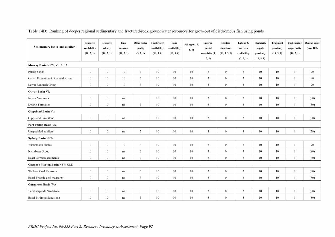
FRDC Project No. 98/335 Part 2: Resource Inventory & Assessment, Page 92
Table 14D: Ranking of deeper regional sedimentary and fractured-rock groundwater resources for grow-out of diadromous fish using ponds
Sedimentary basin and aquiferResource
availability
(10, 5, 1)
Resource
salinity
(10, 5, 1)
Ionic
makeup
(10, 5, 1)
Other water
quality
(3, 2, 1)
Freshwater
availability
(10, 5, 0)
Land
availability
(10, 5, 0)
Soil type (10,
5, 0)
Environ-
mental
sensitivity (3,
2, 1)
Existing
structures
(10, 5, 3, 0)
Labour &
services
availability
(3, 2, 1)
Electricity
supply
proximity
(10, 5, 1)
Transport
proximity
(10, 5, 1)
Cost sharing
opportunity
(10, 5, 1)
Overall score
(max 109)
Murray Basin NSW, Vic & SA
Parilla Sands 10 10 10 3 10 10 10 3 0 3 10 10 1 90
Calivil Fromation & Renmark Group 10 10 10 3 10 10 10 3 0 3 10 10 1 90
Lower Renmark Group 10 10 10 3 10 10 10 3 0 3 10 10 1 90
Otway Basin Vic
Newer Volcanics 10 10 na 3 10 10 10 3 0 3 10 10 1 (80)
Dylwin Formation 10 10 na 3 10 10 10 3 0 3 10 10 1 (80)
Gippsland Basin Vic
Gippsland Limestone 10 10 na 3 10 10 10 3 0 3 10 10 1 (80)
Port Phillip Basin Vic
Unspecified aquifers 10 10 na 2 10 10 10 3 0 3 10 10 1 (79)
Sydney Basin NSW
Wianamatta Shales 10 10 10 3 10 10 10 3 0 3 10 10 1 90
Narrabeen Group 10 10 na 3 10 10 10 3 0 3 10 10 1 (80)
Basal Permian sediments 10 10 na 3 10 10 10 3 0 3 10 10 1 (80)
Clarence-Morton Basin NSW-QLD
Walloon Coal Measures 10 10 na 3 10 10 10 3 0 3 10 10 1 (80)
Basal Triassic coal measures 10 10 na 3 10 10 10 3 0 3 10 10 1 (80)
Carnarvon Basin WA
Tumbalagooda Sandstone 10 10 na 3 10 10 10 3 0 3 10 10 1 (80)
Basal Birdrong Sandstone 10 10 na 3 10 10 10 3 0 3 10 10 1 (80)
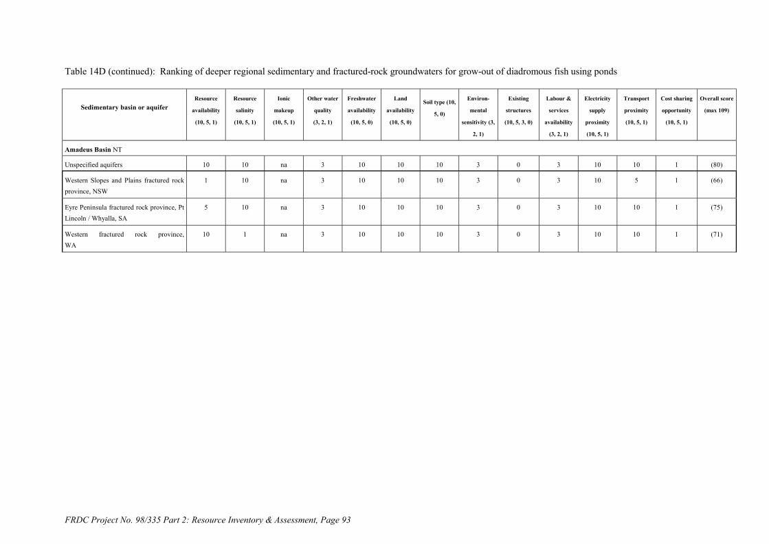
FRDC Project No. 98/335 Part 2: Resource Inventory & Assessment, Page 93
Table 14D (continued): Ranking of deeper regional sedimentary and fractured-rock groundwaters for grow-out of diadromous fish using ponds
Sedimentary basin or aquiferResource
availability
(10, 5, 1)
Resource
salinity
(10, 5, 1)
Ionic
makeup
(10, 5, 1)
Other water
quality
(3, 2, 1)
Freshwater
availability
(10, 5, 0)
Land
availability
(10, 5, 0)
Soil type (10,
5, 0)
Environ-
mental
sensitivity (3,
2, 1)
Existing
structures
(10, 5, 3, 0)
Labour &
services
availability
(3, 2, 1)
Electricity
supply
proximity
(10, 5, 1)
Transport
proximity
(10, 5, 1)
Cost sharing
opportunity
(10, 5, 1)
Overall score
(max 109)
Amadeus Basin NT
Unspecified aquifers 10 10 na 3 10 10 10 3 0 3 10 10 1 (80)
Western Slopes and Plains fractured rockprovince, NSW
1 10 na 3 10 10 10 3 0 3 10 5 1 (66)
Eyre Peninsula fractured rock province, PtLincoln / Whyalla, SA
5 10 na 3 10 10 10 3 0 3 10 10 1 (75)
Western fractured rock province,WA
10 1 na 3 10 10 10 3 0 3 10 10 1 (71)

FRDC Project No. 98/335 Part 2: Resource Inventory & Assessment, Page 94
Table 15: Ranking of Identified Saline Water Resource Interception and or Disposal Schemes for Native Fish Based on Recirculation (A)
Saline water resource and nearest
major location
Resource
availability
(10, 5, 1)
Resource
salinity
(10, 5, 1)
Ionic makeup
(10, 5, 1)
Other water
quality
(3, 2, 1)
Freshwater
availability
(10, 5, 0)
Land
availability
(10, 5, 0)
Soil type (10,
5, 0)
Environ-
mental
sensitivity (3,
2, 1)
Existing
structures
(10, 5, 3, 1)
Labour &
services
availability
(3, 2, 1)
Electricity
supply
proximity
(10, 5, 1)
Transport
proximity
(10, 5, 1)
Cost sharing
opportunity
(10, 5, 1)
Overall score
(max 109)
Woolpunda Goundwater Interception Scheme -
Stockyard Plain Basin, Waikerie, SA
10 1 10 3 10 10 10 2 10 3 5 5 5 84
Waikerie Salt Interception Scheme - Stockyard
Plain Basin, Waikerie, SA
10 1 10 3 10 10 10 2 10 3 5 5 5 84
Noora Drainage Diversion Scheme, Berri /
Loxton, SA
5 1 10 2 5 10 10 2 10 3 5 5 5 73
Rufus River Goundwater Interception Scheme,
Lake Victoria, NSW
10 1 10 3 5 10 10 3 10 1 5 1 5 74
Mildura-Merbein Goundwater Interception
Scheme, Mildura, Vic
10 1 10 3 10 10 10 3 10 3 5 10 5 90
Buronga Salt Interception Scheme, Mildura, Vic 10 1 10 3 5 10 10 3 10 2 5 10 5 84
Mallee Cliffs Salt Interception Scheme, Mildura,
Vic
10 1 10 3 10 10 10 2 10 2 5 10 5 88
Wakool Salinity Control Scheme, Wakool, NSW 10 1 10 2 10 10 10 3 10 2 10 1 10 89
Barr Creek Salinity Control Scheme, Kerang, Vic 10 1 na 2 10 10 10 1 10 3 10 5 5 (77)
Girgarre Basin Salinity Control Project, Stanhope,
Vic
10 1 10 2 5 10 10 3 10 2 10 1 5 79
Pyramid Hill Groundwater Interception &Salt
Harvesting Scheme, Kerang, Vic (private)
10 1 10 2 10 10 10 3 5 2 10 5 ? (78)

FRDC Project No. 98/335 Part 2: Resource Inventory & Assessment, Page 95
Table 15B: Ranking of proposed groundwater disposal schemes and other potential saline water resources for native fish based on recirculation
Saline water resource and nearestmajor location
Resource
availability
(10, 5, 1)
Resource
salinity
(10, 5, 1)
Ionic
makeup
(10, 5, 1)
Other water
quality
(3, 2, 1)
Freshwater
availability
(10, 5, 0)
Land
availability
(10, 5, 0)
Soil type (10,
5, 0)
Environ-
mental
sensitivity (3,
2, 1)
Existing
structures
(10, 5, 3, 0)
Labour &
services
availability
(3, 2, 1)
Electricity
supply
proximity
(10, 5, 1)
Transport
proximity
(10, 5, 1)
Cost sharing
opportunity
(10, 5, 1)
Overall score
(max 109)
Qualco-Sunlands Groundwater Interception & Salinity
Control Scheme /Stockyard Basin, Waikerie, SA
10 1 10 2 10 10 10 2 5 3 5 5 10 83
Waikerie Stage II Salt Interception Scheme /
Stockyard Basin, Waikerie, SA
10 1 10 3 10 10 10 2 5 3 5 5 10 84
Pyramid Creek Groundwater Interception
Scheme, Kerang, Vic
10 1 10 3 10 10 10 3 3 3 5 5 10 83
Lindsay River Groundwater Interception Scheme,
Mildura, Vic
10 1 10 3 5 10 10 1 3 1 5 1 10 70
Chowilla Groundwater Interception Scheme,
Renmark, SA
10 1 10 3 5 10 10 1 3 3 5 5 10 76
Bookpurnong-Loxton Groundwater Interception
& Drainage Scheme / Noora Basin, Berri /
Loxton, SA
10 1 10 2 5 10 10 2 3 3 5 5 10 76
North Pike-Murtho Salt Interception Scheme,
Paringa, SA
10 1 10 3 10 10 10 3 0 3 5 5 10 80
Yanda Creek Groundwater Interception Scheme,
Louth (Darling River), NSW
10 1 10 3 5 10 10 2 0 1 1 1 10 64
Urban groundwater pumping schemes– various in
MDB and WA e.g. Wagga, NSW
10 10 10 1 10 10 10 3 3 3 10 10 10 100
Ord River Irrigation Area groundwater pumping
schemes, Kununurra, WA
10 10 10 2 10 10 10 3 3 2 5 5 10 90
Esperance-Kalgoorlie seawater pipeline,
Esperance and Kalgoorlie, WA
10 1 10 3 10 10 10 3 3 3 10 10 10 93
On-farm Serial Biological-Concentration projects,
Murray-Darling Basin and WA
5 10 10 2 0 10 10 3 0 1 5 1 10 67
Coal mine drainage water – various NSW and
QLD
10 10 10 1 10 10 10 3 5 3 10 10 10 102

FRDC Project No. 98/335 Part 2: Resource Inventory & Assessment, Page 96
Table 15C: Ranking of Victorian permanent saline lakes for native fish based on recirculation
Saline water resource and nearestmajor location
Resource
availability
(10, 5, 1)
Resource
salinity
(10, 5, 1)
Ionic
makeup
(10, 5, 1)
Other water
quality
(3, 2, 1)
Freshwater
availability
(10, 5, 0)
Land
availability
(10, 5, 0)
Soil type (10,
5, 0)
Environ-
mental
sensitivity (3,
2, 1)
Existing
structures
(10, 5, 3, 0)
Labour &
services
availability
(3, 2, 1)
Electricity
supply
proximity
(10, 5, 1)
Transport
proximity
(10, 5, 1)
Cost sharing
opportunity
(10, 5, 1)
Overall score
(max 109)
Lake Corangamite, Colac, Vic 10 1 10 2 5 10 10 1 0 3 10 5 1 68
Lake Bullen Merri, Colac, Vic 10 10 10 2 5 10 10 2 0 3 10 5 1 78
Lake Purrumbete, Colac, Vic 10 10 10 2 5 10 10 2 0 3 10 5 1 78
Lake Martin, Colac, Vic 10 10 10 2 5 10 10 1 0 3 10 5 1 77
Lake Gnarpurt, Colac, Vic 10 10 10 2 5 10 10 1 0 3 10 5 1 77
Lake Colac, Colac, Vic 10 10 10 2 5 10 10 2 0 3 10 5 1 78
Lake Gnotuk, Colac, Vic 10 1 10 2 5 10 10 1 0 3 10 5 1 68
Lake Colongulac, Colac, Vic 10 10 10 2 5 10 10 1 0 3 10 5 1 77
East Basin Lake, Colac, Vic 10 na na 2 5 10 10 1 0 3 10 5 1 (57)
West Basin Lake, Colac, Vic 10 na na 2 5 10 10 1 0 3 10 5 1 (57)
Lake Tutchewop, Kerang, Vic 10 1 na 2 10 10 10 1 5 3 10 10 10 (82)
Cullens Lake, Kerang, Vic 10 1 na 2 10 10 10 1 5 3 10 10 5 (77)
Lake Kelly, Kerang, Vic 10 1 na 2 10 10 10 1 5 3 10 10 10 (82)
Lake William, Kerang, Vic 10 1 na 2 10 10 10 1 5 3 10 10 10 (82)
Lake Elizabeth, Kerang, Vic 10 1 na 2 10 10 10 2 5 3 10 10 5 (78)
Lake Wandella, Kerang, Vic 10 1 na 2 10 10 10 2 5 3 10 10 5 (78)
Little Lake Kelly, Kerang, Vic 10 1 na 2 10 10 10 2 5 3 10 10 10 (83)
Lake Charm, Kerang, Victoria 10 10 na 2 10 10 10 1 5 3 10 10 10 (91)
Lookout Lake, Kerang, Vic 10 10 na 2 10 10 10 2 5 3 10 10 5 (87)

FRDC Project No. 98/335 Part 2: Resource Inventory & Assessment, Page 97
Table 15D: Ranking of deeper regional sedimentary and fractured-rock groundwater resources for native fish based on recirculation
Sedimentary basin and aquiferResource
availability
(10, 5, 1)
Resource
salinity
(10, 5, 1)
Ionic
makeup
(10, 5, 1)
Other water
quality
(3, 2, 1)
Freshwater
availability
(10, 5, 0)
Land
availability
(10, 5, 0)
Soil type (10,
5, 0)
Environ-
mental
sensitivity (3,
2, 1)
Existing
structures
(10, 5, 3, 0)
Labour &
services
availability
(3, 2, 1)
Electricity
supply
proximity
(10, 5, 1)
Transport
proximity
(10, 5, 1)
Cost sharing
opportunity
(10, 5, 1)
Overall score
(max 109)
Murray Basin NSW, Vic & SA
Parilla Sands 10 1 10 3 10 10 10 3 0 3 10 10 1 81
Calivil Fromation & Renmark Group 10 1 10 3 10 10 10 3 0 3 10 10 1 81
Lower Renmark Group 10 1 10 3 10 10 10 3 0 3 10 10 1 81
Otway Basin
Newer Volcanics 10 10 na 3 10 10 10 3 0 3 10 10 1 (80)
Dylwin Formation 10 10 na 3 10 10 10 3 0 3 10 10 1 (80)
Gippsland Basin Vic
Gippsland Limestone 10 10 na 3 10 10 10 3 0 3 10 10 1 (80)
Port Phillip Basin Vic
Unspecified aquifers 10 10 na 2 10 10 10 3 0 3 10 10 1 (79)
Sydney Basin NSW
Wianamatta Shales 10 1 10 3 10 10 10 3 0 3 10 10 1 81
Narrabeen Group 10 10 na 3 10 10 10 3 0 3 10 10 1 (80)
Basal Permian sediments 10 10 na 3 10 10 10 3 0 3 10 10 1 (80)
Clarence-Morton Basin NSW-QLD
Walloon Coal Measures 10 1 na 3 10 10 10 3 0 3 10 10 1 (71)
Basal Triassic coal measures 10 1 na 3 10 10 10 3 0 3 10 10 1 (71)
Carnarvon Basin WA
Tumbalagooda Sandstone 10 1 na 3 10 10 10 3 0 3 10 10 1 (71)
Basal Birdrong Sandstone 10 10 na 3 10 10 10 3 0 3 10 10 1 (80)

FRDC Project No. 98/335 Part 2: Resource Inventory & Assessment, Page 98
Table 15D (continued): Ranking of deeper regional sedimentary and fractured-rock groundwater resources for native fish based on recirculation
Sedimentary basin or aquiferResource
availability
(10, 5, 1)
Resource
salinity
(10, 5, 1)
Ionic
makeup
(10, 5, 1)
Other water
quality
(3, 2, 1)
Freshwater
availability
(10, 5, 0)
Land
availability
(10, 5, 0)
Soil type (10,
5, 0)
Environ-
mental
sensitivity (3,
2, 1)
Existing
structures
(10, 5, 3, 0)
Labour &
services
availability
(3, 2, 1)
Electricity
supply
proximity
(10, 5, 1)
Transport
proximity
(10, 5, 1)
Cost sharing
opportunity
(10, 5, 1)
Overall score
(max 109)
Amadeus Basin NT
Unspecified aquifers 10 1 na 3 10 10 10 3 0 3 10 10 1 (71)
Western Slopes and Plains fractured rockprovince, NSW
10 1 na 3 10 10 10 3 0 3 10 5 1 (66)
Eyre Peninsula fractured rock province, PtLincoln / Whyalla, SA
10 1 na 3 10 10 10 3 0 3 10 10 1 (71)
Western fractured rock province,Canarvon, WA
10 1 na 3 10 10 10 3 0 3 10 10 1 (71)

FRDC Project No. 98/335 Part 2: Resource Inventory & Assessment, Page 99
Table 16: Ranking of Identified Saline Water Resource Interception and or Disposal Schemes for Native Fish Based Ponds (A)
Saline water resource and nearest
major location
Resource
availability
(10, 5, 1)
Resource
salinity
(10, 5, 1)
Ionic makeup
(10, 5, 1)
Other water
quality
(3, 2, 1)
Freshwater
availability
(10, 5, 0)
Land
availability
(10, 5, 0)
Soil type (10,
5, 0)
Environ-
mental
sensitivity (3,
2, 1)
Existing
structures
(10, 5, 3, 1)
Labour &
services
availability
(3, 2, 1)
Electricity
supply
proximity
(10, 5, 1)
Transport
proximity
(10, 5, 1)
Cost sharing
opportunity
(10, 5, 1)
Overall score
(max 109)
Woolpunda Goundwater Interception Scheme -
Stockyard Plain Basin, Waikerie, SA
10 1 10 3 10 10 5 2 10 3 5 5 5 79
Waikerie Salt Interception Scheme - Stockyard
Plain Basin, Waikerie, SA
10 1 10 3 10 10 5 2 10 3 5 5 5 79
Noora Drainage Diversion Scheme, Berri /
Loxton, SA
5 1 10 2 5 10 5 2 10 3 5 5 5 68
Rufus River Goundwater Interception Scheme,
Lake Victoria, NSW
10 1 10 3 5 10 5 3 10 1 5 1 5 69
Mildura-Merbein Goundwater Interception
Scheme, Mildura, Vic
10 1 10 3 10 10 5 3 10 3 5 10 5 85
Buronga Salt Interception Scheme, Mildura, Vic 10 1 10 3 5 10 5 3 10 2 5 10 5 79
Mallee Cliffs Salt Interception Scheme, Mildura,
Vic
10 1 10 3 10 10 5 2 10 2 5 10 5 83
Wakool Salinity Control Scheme, Wakool, NSW 10 1 5 2 10 10 5 3 10 2 10 1 10 79
Barr Creek Salinity Control Scheme, Kerang, Vic 10 1 na 2 10 10 5 1 10 3 10 5 5 (72)
Girgarre Basin Salinity Control Project, Stanhope,
Vic
10 1 10 2 5 10 5 3 10 2 10 1 5 74
Pyramid Hill Groundwater Interception &Salt
Harvesting Scheme, Kerang, Vic (private)
1 1 10 2 10 5 0 3 5 2 10 5 ? (54)

FRDC Project No. 98/335 Part 2: Resource Inventory & Assessment, Page 100
Table 16B: Ranking of proposed groundwater disposal schemes and other potential saline water resources for native fish based ponds
Saline water resource and nearestmajor location
Resource
availability
(10, 5, 1)
Resource
salinity
(10, 5, 1)
Ionic
makeup
(10, 5, 1)
Other water
quality
(3, 2, 1)
Freshwater
availability
(10, 5, 0)
Land
availability
(10, 5, 0)
Soil type (10,
5, 0)
Environ-
mental
sensitivity (3,
2, 1)
Existing
structures
(10, 5, 3, 0)
Labour &
services
availability
(3, 2, 1)
Electricity
supply
proximity
(10, 5, 1)
Transport
proximity
(10, 5, 1)
Cost sharing
opportunity
(10, 5, 1)
Overall score
(max 109)
Qualco-Sunlands Groundwater Interception & Salinity
Control Scheme /Stockyard Basin, Waikerie, SA
10 1 10 2 10 10 5 2 5 3 5 5 10 78
Waikerie Stage II Salt Interception Scheme /
Stockyard Basin, Waikerie, SA
10 1 10 3 10 10 5 2 5 3 5 5 10 79
Pyramid Creek Groundwater Interception
Scheme, Kerang, Vic
10 1 10 3 10 10 5 3 3 3 5 5 10 78
Lindsay River Groundwater Interception Scheme,
Mildura, Vic
10 1 10 3 5 10 5 1 3 1 5 1 10 65
Chowilla Groundwater Interception Scheme,
Renmark, SA
10 1 10 3 5 10 5 1 3 3 5 5 10 71
Bookpurnong-Loxton Groundwater Interception
& Drainage Scheme / Noora Basin, Berri /
Loxton, SA
10 1 10 2 5 10 5 2 3 3 5 5 10 71
North Pike-Murtho Salt Interception Scheme,
Paringa, SA
10 1 10 3 10 10 5 3 0 3 5 5 10 75
Yanda Creek Groundwater Interception Scheme,
Louth (Darling River), NSW
10 1 10 3 5 10 5 2 0 1 1 1 10 59
Urban groundwater pumping schemes– various in
MDB and WA e.g. Wagga, NSW
5 10 10 1 10 10 5 3 3 3 10 10 10 90
Ord River Irrigation Area groundwater pumping
schemes, Kununurra, WA
10 10 10 2 10 10 5 3 3 2 5 5 10 85
Esperance-Kalgoorlie seawater pipeline,
Esperance and Kalgoorlie, WA
10 1 10 3 10 10 5 3 3 3 10 10 10 88
On-farm Serial Biological-Concentration projects,
Murray-Darling Basin and WA
1 10 10 2 0 10 5 3 0 1 5 1 10 58
Coal mine drainage water – various NSW and
QLD
10 10 10 1 10 10 5 3 5 3 10 10 10 97

FRDC Project No. 98/335 Part 2: Resource Inventory & Assessment, Page 101
Table 16C: Ranking of Victorian permanent saline lakes for native fish based ponds
Saline water resource and nearestmajor location
Resource
availability
(10, 5, 1)
Resource
salinity
(10, 5, 1)
Ionic
makeup
(10, 5, 1)
Other water
quality
(3, 2, 1)
Freshwater
availability
(10, 5, 0)
Land
availability
(10, 5, 0)
Soil type (10,
5, 0)
Environ-
mental
sensitivity (3,
2, 1)
Existing
structures
(10, 5, 3, 0)
Labour &
services
availability
(3, 2, 1)
Electricity
supply
proximity
(10, 5, 1)
Transport
proximity
(10, 5, 1)
Cost sharing
opportunity
(10, 5, 1)
Overall score
(max 109)
Lake Corangamite, Colac, Vic 10 1 10 2 5 10 5 1 0 3 10 5 1 63
Lake Bullen Merri, Colac, Vic 10 10 10 2 5 10 5 2 0 3 10 5 1 73
Lake Purrumbete, Colac, Vic 10 10 10 2 5 10 5 2 0 3 10 5 1 73
Lake Martin, Colac, Vic 10 10 10 2 5 10 5 1 0 3 10 5 1 72
Lake Gnarpurt, Colac, Vic 10 10 10 2 5 10 5 1 0 3 10 5 1 72
Lake Colac, Colac, Vic 10 10 10 2 5 10 5 2 0 3 10 5 1 73
Lake Gnotuk, Colac, Vic 10 1 10 2 5 10 5 1 0 3 10 5 1 63
Lake Colongulac, Colac, Vic 10 10 10 2 5 10 5 1 0 3 10 5 1 72
East Basin Lake, Colac, Vic 10 na na 2 5 10 5 1 0 3 10 5 1 (52)
West Basin Lake, Colac, Vic 10 na na 2 5 10 5 1 0 3 10 5 1 (52)
Lake Tutchewop, Kerang, Vic 10 1 na 2 10 10 5 1 5 3 10 10 10 (77)
Cullens Lake, Kerang, Vic 10 1 na 2 10 10 5 1 5 3 10 10 5 (72)
Lake Kelly, Kerang, Vic 10 1 na 2 10 10 5 1 5 3 10 10 10 (77)
Lake William, Kerang, Vic 10 1 na 2 10 10 5 1 5 3 10 10 10 (77)
Lake Elizabeth, Kerang, Vic 10 1 na 2 10 10 5 2 5 3 10 10 5 (73)
Lake Wandella, Kerang, Vic 10 1 na 2 10 10 5 2 5 3 10 10 5 (73)
Little Lake Kelly, Kerang, Vic 10 1 na 2 10 10 5 2 5 3 10 10 10 (78)
Lake Charm, Kerang, Victoria 10 10 na 2 10 10 5 1 5 3 10 10 10 (86)
Lookout Lake, Kerang, Vic 10 10 na 2 10 10 5 2 5 3 10 10 5 (82)
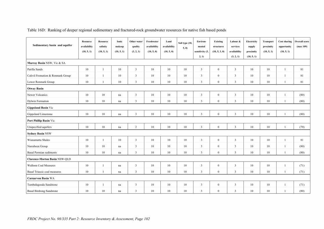
FRDC Project No. 98/335 Part 2: Resource Inventory & Assessment, Page 102
Table 16D: Ranking of deeper regional sedimentary and fractured-rock groundwater resources for native fish based ponds
Sedimentary basin and aquiferResource
availability
(10, 5, 1)
Resource
salinity
(10, 5, 1)
Ionic
makeup
(10, 5, 1)
Other water
quality
(3, 2, 1)
Freshwater
availability
(10, 5, 0)
Land
availability
(10, 5, 0)
Soil type (10,
5, 0)
Environ-
mental
sensitivity (3,
2, 1)
Existing
structures
(10, 5, 3, 0)
Labour &
services
availability
(3, 2, 1)
Electricity
supply
proximity
(10, 5, 1)
Transport
proximity
(10, 5, 1)
Cost sharing
opportunity
(10, 5, 1)
Overall score
(max 109)
Murray Basin NSW, Vic & SA
Parilla Sands 10 1 10 3 10 10 10 3 0 3 10 10 1 81
Calivil Fromation & Renmark Group 10 1 10 3 10 10 10 3 0 3 10 10 1 81
Lower Renmark Group 10 1 10 3 10 10 10 3 0 3 10 10 1 81
Otway Basin
Newer Volcanics 10 10 na 3 10 10 10 3 0 3 10 10 1 (80)
Dylwin Formation 10 10 na 3 10 10 10 3 0 3 10 10 1 (80)
Gippsland Basin Vic
Gippsland Limestone 10 10 na 3 10 10 10 3 0 3 10 10 1 (80)
Port Phillip Basin Vic
Unspecified aquifers 10 10 na 2 10 10 10 3 0 3 10 10 1 (79)
Sydney Basin NSW
Wianamatta Shales 10 1 10 3 10 10 10 3 0 3 10 10 1 81
Narrabeen Group 10 10 na 3 10 10 10 3 0 3 10 10 1 (80)
Basal Permian sediments 10 10 na 3 10 10 10 3 0 3 10 10 1 (80)
Clarence-Morton Basin NSW-QLD
Walloon Coal Measures 10 1 na 3 10 10 10 3 0 3 10 10 1 (71)
Basal Triassic coal measures 10 1 na 3 10 10 10 3 0 3 10 10 1 (71)
Carnarvon Basin WA
Tumbalagooda Sandstone 10 1 na 3 10 10 10 3 0 3 10 10 1 (71)
Basal Birdrong Sandstone 10 10 na 3 10 10 10 3 0 3 10 10 1 (80)

FRDC Project No. 98/335 Part 2: Resource Inventory & Assessment, Page 103
Table 16D (continued): Ranking of deeper regional sedimentary and fractured-rock groundwater resources for native fish based ponds
Sedimentary basin or aquiferResource
availability
(10, 5, 1)
Resource
salinity
(10, 5, 1)
Ionic
makeup
(10, 5, 1)
Other water
quality
(3, 2, 1)
Freshwater
availability
(10, 5, 0)
Land
availability
(10, 5, 0)
Soil type (10,
5, 0)
Environ-
mental
sensitivity (3,
2, 1)
Existing
structures
(10, 5, 3, 0)
Labour &
services
availability
(3, 2, 1)
Electricity
supply
proximity
(10, 5, 1)
Transport
proximity
(10, 5, 1)
Cost sharing
opportunity
(10, 5, 1)
Overall score
(max 109)
Amadeus Basin NT
Unspecified aquifers 10 1 na 3 10 10 10 3 0 3 10 10 1 (71)
Western Slopes and Plains fractured rockprovince, NSW
1 1 na 3 10 10 10 3 0 3 10 5 1 (57)
Eyre Peninsula fractured rock province, PtLincoln / Whyalla, SA
5 1 na 3 10 10 10 3 0 3 10 10 1 (66)
Western fractured rock province,Canarvon, WA
10 1 na 3 10 10 10 3 0 3 10 10 1 (71)

104 NSW Fisheries
FRDC Project No. 98/335 Part 2: Resource Inventory & Assessment Allan, Banens & Fielder
8.13. References and Source Materials
Allan, A.D., Laws, A.T. and D.P. Commander, 1992. A review of the major groundwaterresources in Western Australia. Report to Kimberley Water Resources Development Office.
ANCA, 1996. A Directory of Important Wetlands in Australia (2nd edition). Australian NatureConservation Agency, Canberra. 968p.
Banens, R.J., 1987. The geochemical character of upland waters of northeast New South Wales.Limnology & Oceanography 32: 1291-1306.
Bowmer, K.H., Fairweather, P.G., Napier, G.M. & A.C. Scott, 1996. Biological Impact of CottonPesticides. Occasional Paper No.03/96, Land and Water Resources Research andDevelopment Corporation. 110p.
Bowmer, K.H., Roberts, J., Scott, A.C., Napier, G.M. and W. Korth, 1995. Aquaculture andpesticides in the NSW Riverina.: NSW OLMA Aquaculture, Fishing & related IndustriesCommission. CSIRO Division of Water Resources report, 44pp.
Brody, R., Hostetler, S., & B. Radke, 1995. Database of evaporation disposal basins in theMurray Basin. Australian Geological Survey Organisation, Canberra. 39p.
Cobb, M.A., Armstrong, D., Barnett, S., Read, R., Sibenaler, X. Smith, P.C. & M.H. Stadter, 1982.A review of fractured rock environments in South Australia. In Papers of the FracturedRock Conference, Canberrra (pp. 35-46). AWRC Conference Series 5.
Crabb, P., 1997. Murray-Darling Basin Resources. Murray-Darling Basin Commission. 300pp.De Deckker, P. and W.D. Williams, 1988. Physico-chemical limnology of eleven, mostly saline
permanent lakes in western Victoria, Australia. Hydrobiologia 162: 275-286.DENR, 1995. Evaluation of Saline Water Disposal Basins along the River Murray in South
Australia. Water Resources Report 9/95, Department of Environment and NaturalResources, Berri. 50pp. plus appendices and diagrams.
EPA, 1976. Water Quality of Lake Colac. EPA Report 9/76, Environment Protection Authority ofVictoria.
Evans, R.S. 1989. Saline water disposal options in the Murray Basin. BMR Journal of Geology& Geophysics 11: 167-185.
Evans, W.R. (compiler) 1988. Preliminary Shallow Groundwater and Salinity Map of the MurrayBasin (1:1,000,000 scale map). Bureau of Mineral Resources, Canberra.
Gunn, R.H. and D.P. Richardson, 1979. The nature and possible origins of soluble salts in deeplyweathered landscapes of eastern Australia. Australian Journal of Soil Research 17: 197-215.
Hem, J.D., 1985. Study and Interpretation of the Chemical Characteristics of Natural Water. (3rd
edition) United States Geological Survey Water-Supply Paper 2254, 264pp.Heuperman, A., 1998. Value adding serial biological concentration for improved environmental
management. In: 1998 Irrigation Forum (Ed. P.A. Jones, p.39-40). Murray-Darling BasinCommission, Canberra.
Hostetler, S., Brodie, R., & R. Brodie, 1997. Murray-Darling Basin Irrigation Infrastructure GIS(IIGIS). AGSO Record 1997/42, Australian Geological Survey Organisation, Canberra.
Hostetler, S. and B. Radke, 1995. An inventory of saline disposal basins, Murray Basin. AGSORecord 1995/4. Australian Geological Survey Organisation, Canberra. Volumes 1 & 2,846p.
Hoxley, G., 1993. Criteria for the Evaluation of Disposal Basins. Technical Note TN/86/93.Rural Water Corporation, Victoria. 6pp.
Johnson, M., 1980. The origin of Australia’s salt lakes. Records of the Geological Survey ofNSW. 19: 221-266.
Lau, J.E., Commander, D.P. & G. Jacobson, 1987. Hydrogeology of Australia. Bureau of MineralResources, Geology and Geophysics. Bulletin 227, 21pp.
Lindsay, J.M. and S.R. Barnett, 1989. Aspects of the stratigraphy and structure in relation to theWoolpunda Groundwater Interception Scheme, Murray Basin, South Australia. BMRJournal of Australian Geology & Geophysics 11: 219-225.

NSW Fisheries 105
FRDC Project No. 98/335 Part 2: Resource Inventory & Assessment Allan, Banens & Fielder
LMA Partnership Pty Ltd, 1992. Utilising Water Disposed of to Existing and Future EvaporationDisposal Basins for Salt Harvesting, Solar Ponds and Aquaculture. Report to the RuralWater Corporation (MDBC NRMS funded project V237). (Report was not sighted).
Matta, J., 1999. The Rural Towns Program - Groundwater Modeling The Merredin Catchment.Agriculture WA report.
MDBC 1999a. Salinity and Drainage Strategy - Ten years on: 1999. Murray-Darling BasinCommission. 17pp.
MDBC 1999b. Groundwater: A Resource for the Future. Murray-Darling Basin Commission.31pp.
MDBC 1999c. The Salinity Audit of the Murray-Darling Basin: A 100-year perspective. Murray-Darling Basin Commission. 39pp.
MDBC 1999. Salinity and Drainage Strategy (Natural Resource Management Strategy)http://www.mdbc.gov.au/NRM/Salinity_Drain_Strategy/Salinity_and_Drainage.htm
Oliver, M. et al., 1996. Costs of Salinity to Government Agencies and Public Utilities in theMurray-Darling Basin. ABARE Research Report 96.2. Australian Bureau of Agriculturaland Resource Economics, Canberra.
RMC, 1984. Rufus River Salt Interception Scheme. Pamphlet River Murray Commission. 4pp.Sedgmen, H., 1999. An inventory of saline waste disposal basins, Murray Basin: Volume 3,
Additional basins in South Australia, Victoria and New South Wales. AGSO Record1999/21. Australian Geological Survey Organisation, Canberra. Volume 3, 847-907 pp.
Simmons, C.T., Yan, W. and K.A. Narayan, 1999. Characterisation and Ranking of SalineDisposal Basins in the Murray Basin of South-Eastern Australia. Unpublished report, 29pp.
Sinclair Knight Merz, 1996. Database of Victorian Drainage Disposal Basins – status report.Report to the Murray-Darling Basin Commission.
SKM, 1999. Barr Creek Review of Scheme Operations 1997/98. Report by Sinclair Knight Merzfor Goulburn-Murray Water.
Smith, B. and C. Barlow, 1999. Inland Saline Aquaculture Workshop. Proc. workshop, Perth WA,August 1997. ACIAR Proceedings No. 83, 61pp.
Timms, B.V., 1976. A comparative study of the limnology of three maar lakes in western Victoria.1. Physiography and physico-chemical features. Australian Journal of Marine andFreshwater Research 27: 35-60.
Timms, B.V., 1983. A study of benthic communities in some shallow saline lakes of westernVictoria, Australia. Hydrobiologia 105: 165-177.
Walker, G., Gilfedder, M. and J. Williams, 1999. Effectiveness of Current Farming Systems in theControl of Dryland Salinity. Report for the Murray-Darling Basin Commission. CSIROLand and Water.
Wasson, R.J., Banens, R.J., Davies, P., Maher, W., Robinson, S., and R. Volker, 1996. InlandWaters, Chapter 7 (pp. 7.1-7.55) in Australia: State of the Environment 1996. Departmentof Environment Sport and Territories, Australian Government.
Williams, W.D., 1981. The limnology of saline lakes in Western Victoria: A review of some recentstudies. Hydrobiologia 82: 233-259.
Williams, W.D. 1978. Limnology of Victorian salt lakes, Australia. Verh. Int. Ver. Limnol. 20:1165-1174.
WRC, 1984. Groundwater in New South Wales. Water Resources Commission, New South Wales
106 NSW Fisheries
FRDC Project No. 98/335 Part 2: Resource Inventory & Assessment Allan, Banens & Fielder
9. BENEFITS
The R&D Plan and Resource Inventory and Assessment will assist existing and potentialaquaculturists, R&D funding agencies, research providers, planners and managers involved withsaline groundwater control and rural communities.
Existing aquaculturists will benefit from having major constraints to commercial developmentidentified and brought to the attention of potential research funding agencies and researchproviders. This should improve funding opportunities to address these constraints. The Projectwill also benefit this group by focusing attention on the merit of utilising degraded resources(saline groundwater and saline affected land) for a commercial business. Aquaculture is one of thefew business opportunities with saline groundwater. This recognition should generate increasedgovernment and community support for aquaculture using saline groundwater.
Potential aquaculturists will benefit for reasons given above and also because planners andmanagers involved with saline groundwater control will be aware of opportunities to integrateaquaculture with new saline groundwater control schemes. This integration could help defraycapital and operating costs (for water supply and disposal) for the new aquaculture operation andmake obtaining government approvals much easier.
R&D funding agencies and research providers will benefit by having genuine commercialopportunities identified and research issues listed.
Planners and managers involved with saline groundwater control will benefit by having access toinformation on aquaculture opportunities which will help them plan for integration of aquaculturein new saline groundwater control schemes. As these opportunities are realised, and commercialinland saline aquaculture develops, the costs of saline groundwater control schemes will beconsiderably reduced. Aquaculture ponds are just as effective for evaporation as purpose builtevaporation ponds. New control schemes might include high-capacity groundwater pumps (maybefrom many bores) and relatively small evaporation ponds. The operators of the schemes could“sell” saline water to aquaculturists and then “sell” the right for them to dispose of their effluent inthe schemes’ evaporation ponds.
Rural communities should benefit from the Project as it will speed up commercial development ofcommercial inland saline aquaculture. New business opportunities from this new industry willprovide economic development and employment.

NSW Fisheries 107
FRDC Project No. 98/335 Part 2: Resource Inventory & Assessment Allan, Banens & Fielder
10. FURTHER DEVELOPMENTS
The enormous problem with rising saline groundwater is achieving increased national recognition.The National Dryland Salinity Program (NDSP) that was established in 1993, entered a secondphase in 1998/99. The NDSP was established as a means of improving research, development andextension coordination to better manage dryland salinity across Australia. The threat to productiveagriculture from salinity has long been recognised but it is only since the establishment of theNDSP that the extent of the salinity problem has become apparent. In particular, the threat to ruraland even some metropolitan infrastructure (including roads, buildings and properties),environmental resources and access to quality drinking water supplies have recently becomeapparent. Research, development and extension to make better use of degraded land and salinewater is a key objective of the Phase 2 NDSP.
The Dryland Salinity Program has established a new unit called “Options for the Productive Use ofSalinity (OPUS)”. This unit has recognised aquaculture as having potential in saline affectedareas.
At the launch of the Murray-Darling Basin Commission’s 1999 salinity audit, the Federal Ministerfor the Environment described rising salinity as “the worst environmental problem Australiafaces”.
In Dubbo, NSW on 16-17 Mach 2000, the Premier convened a Salinity Summit to addressproblems, causes and opportunities in a coordinated approach. Over two hundred people attendedthis Summit including eight government ministers, twelve Department heads and senior officialsand representatives of community groups across NSW. Aquaculture was identified as having realpotential in saline affected areas. The recommendations from the working group established toidentify ways of encouraging business initiative included the following:
Encourage farmers to diversify into new salinity compatible products, such as aquaculture insaline ponds (4 other products were also listed);
Support research to develop or validate business initiatives in aquaculture research anddevelopment, including the need for demonstration farms and effective extension services, ininland saline affected areas.
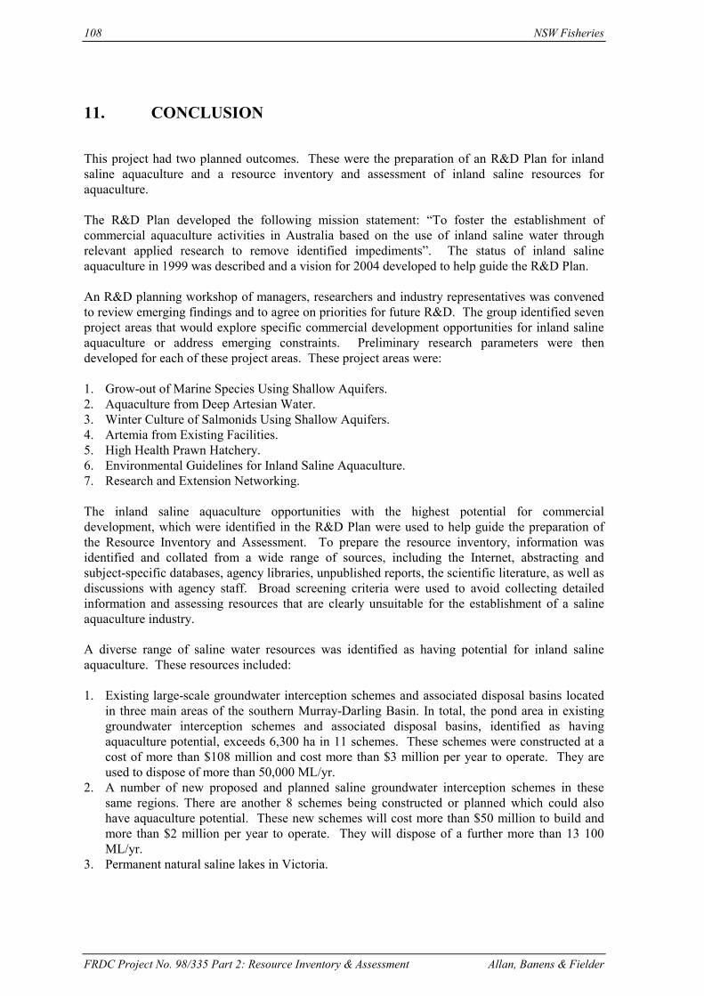
108 NSW Fisheries
FRDC Project No. 98/335 Part 2: Resource Inventory & Assessment Allan, Banens & Fielder
11. CONCLUSION
This project had two planned outcomes. These were the preparation of an R&D Plan for inlandsaline aquaculture and a resource inventory and assessment of inland saline resources foraquaculture.
The R&D Plan developed the following mission statement: “To foster the establishment ofcommercial aquaculture activities in Australia based on the use of inland saline water throughrelevant applied research to remove identified impediments”. The status of inland salineaquaculture in 1999 was described and a vision for 2004 developed to help guide the R&D Plan.
An R&D planning workshop of managers, researchers and industry representatives was convenedto review emerging findings and to agree on priorities for future R&D. The group identified sevenproject areas that would explore specific commercial development opportunities for inland salineaquaculture or address emerging constraints. Preliminary research parameters were thendeveloped for each of these project areas. These project areas were:
1. Grow-out of Marine Species Using Shallow Aquifers.2. Aquaculture from Deep Artesian Water.3. Winter Culture of Salmonids Using Shallow Aquifers.4. Artemia from Existing Facilities.5. High Health Prawn Hatchery.6. Environmental Guidelines for Inland Saline Aquaculture.7. Research and Extension Networking.
The inland saline aquaculture opportunities with the highest potential for commercialdevelopment, which were identified in the R&D Plan were used to help guide the preparation ofthe Resource Inventory and Assessment. To prepare the resource inventory, information wasidentified and collated from a wide range of sources, including the Internet, abstracting andsubject-specific databases, agency libraries, unpublished reports, the scientific literature, as well asdiscussions with agency staff. Broad screening criteria were used to avoid collecting detailedinformation and assessing resources that are clearly unsuitable for the establishment of a salineaquaculture industry.
A diverse range of saline water resources was identified as having potential for inland salineaquaculture. These resources included:
1. Existing large-scale groundwater interception schemes and associated disposal basins locatedin three main areas of the southern Murray-Darling Basin. In total, the pond area in existinggroundwater interception schemes and associated disposal basins, identified as havingaquaculture potential, exceeds 6,300 ha in 11 schemes. These schemes were constructed at acost of more than $108 million and cost more than $3 million per year to operate. They areused to dispose of more than 50,000 ML/yr.
2. A number of new proposed and planned saline groundwater interception schemes in thesesame regions. There are another 8 schemes being constructed or planned which could alsohave aquaculture potential. These new schemes will cost more than $50 million to build andmore than $2 million per year to operate. They will dispose of a further more than 13 100ML/yr.
3. Permanent natural saline lakes in Victoria.

NSW Fisheries 109
FRDC Project No. 98/335 Part 2: Resource Inventory & Assessment Allan, Banens & Fielder
4. Saline and brackish groundwaters from sedimentary basins and fractured rock aquifers aroundAustralia. These were found in all states except Tasmania. A number of brackish geothermalgroundwaters were also identified.
5. Urban groundwater pumping to protect urban infrastructure and property in areas affected bydryland or irrigation-derived salinity. These opportunities for cost-sharing were located in theMurray-Darling Basin and the wheatbelt area of southwest Western Australia. There are some74 rural towns (24 in Victoria, 21 in NSW, 1 in South Australia and 28 in Western Australia)which are experiencing or threatened by rising saline groundwater tables.
6. Proposed shallow groundwater pumping in the Ord River Irrigation Area around Kununurra innorthern WA.
7. Two other unusual saline water resources with exceptional aquaculture potential were alsoidentified. These were the proposed Esperance-Kalgoorlie seawater pipeline and salinedrainage water associated with coal mines in NSW and Queensland.
Thirteen criteria were developed for a preliminary assessment of the potential of these identifiedsaline water resources for the establishment of different aquaculture types (eg hatcheries, growoutof euryhaline or stenohaline fish in ponds or recirculation units, etc). These criteria included theavailability of land and freshwater, the nature of the surrounding environment, existinginfrastructure and services and opportunities for cost sharing. The application of the developedcriteria to potentially suitable saline water resources provided an indicative assessment of thesuitability in relation to the various aquaculture types. A number of saline resources wereidentified as being attractive for a range of aquaculture types. (This is based on a preliminary andindicative assessment using tentative scoring criteria, and often with limited resource information.)These were in particular:
The Esperance-Kalgoorlie seawater pipeline. Most groundwater interception schemes. Most of the Kerang Lakes. Urban groundwater pumping. The aquifers of the Murray Hydrogeological Basin. Coal mine drainage water.

110 NSW Fisheries
FRDC Project No. 98/335 Part 2: Resource Inventory & Assessment Allan, Banens & Fielder
12. APPENDICES

NSW Fisheries 111
FRDC Project No. 98/335 Part 2: Resource Inventory & Assessment Allan, Banens & Fielder
Appendix 1: Ambient Air Temperatures in Representative Irrigation Areas
High LowAverage Max Average Max
QLD Toowoomba 27.6 39.3 5.3 -4.4St George 34.5 45.0 5.4 -2.2Goondiwindi 33.8 43.7 5.1 -3.3
NSW Moree 33.4 44.4 3.8 -5.3Narrabri 33.6 43.4 3.7 -5.6Gunnedah 31.7 41.9 4.0 -5.6Bourke 36.4 51.7 4.6 -2.4Warren 33.9 45.2 2.4 -6.4Narromine 32.0 43.4 2.6 -5.4Forbes 32.7 43.0 2.8 -5.6Lake Cargellicoe 34.0 47.0 3.3 -6.1Griffith 31.5 43.4 2.9 -5.4Hay 32.9 47.2 3.4 -3.6Balranald 33.0 47.7 3.4 -4.8Deniliquin 32.6 46.9 3.4 -4.8Mildura 31.9 46.9 4.3 -4.0
Vic Shepparton 31.1 44.4 3.0 -3.2Bendigo 28.9 41.7 3.5 -3.5Swan Hill 31.4 46.1 4.1 -3.6
SA Renmark 32.4 47.4 5.1 -3.8Waikerie 32.7 46.5 5.0 -3.1Murray Bridge 28.7 45.6 5.4 -5.0
WA Morawa 36.8 47.2 6.1 -1.6Southern Cross 34.6 45.6 4.4 -3.8Narregin 31.4 43.4 5.8 -2.7
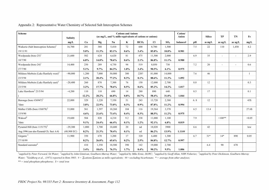
FRDC Project No. 98/335 Part 2: Resource Inventory & Assessment, Page 112
Appendix 2: Representative Water Chemistry of Selected Salt Interception Schemes
Scheme
Salinity
Cations and Anions(as mg/L, and % mille-equivalents of cations or anions)
Cation/Anion Silica TP TN Fe
mg/L Ca Mg Na K HCO3 Cl SO4 balance# pH as mg/L as ug/L as ug/L mg/L
Waikerie (Salt Interception Scheme)1 16,700 281 388 5,410 72 600 8,780 1,500 7.5 22 110 1,450 4.2
19/11/91 5.0% 11.3% 83.1% 0.6% 3.4% 85.8% 10.8% 0.981
Woolpunda (bore-25)1 21,600 502 624 6,620 81 475 11,500 2,000 6.9 35 - - 2.9
10/7/90 6.8% 14.0% 78.6% 0.6% 2.1% 86.8% 11.1% 0.980
Woolpunda (bore-24)1 14,400 250 289 4,750 94 519 8,050 730 7.2 20 - - 0.6
27/7/90 5.1% 9.7% 84.3% 1.0% 3.4% 90.5% 6.1% 0.975
Mildura-Merbein (Lake Ranfurly west)2 ~90,000 1,200 7,000 50,000 300 220? 81,000 14,000 7.6 46 1
23/5/94 2.1% 20.4% 77.2% 0.3% 0.1% 88.6% 11.3% 1.092
Mildura-Merbein (Lake Ranfurly east)2 ~20,400 260 870 7,300 76 150 12,000 2,700 8.8 12 0.3
23/5/94 3.2% 17.7% 78.6% 0.5% 0.6% 85.2% 14.2% 1.017
Lake Hawthorn2 23/5/94 ~4,200 110 110 690 14 280 890 640 8.5 17 0.1
( 12.2% 20.2% 66.8% 0.8% 10.7% 58.4% 31.0% 1.044
Buronga (bore #36947)3 22,000 329 1,220 7,350 51 243 13,720 2,380 6. 8 12 43$
?date 3.8% 22.9% 73.0% 0.3% 0.9% 87.8% 11.2% 0.994
Mallee Cliffs (bore #36878)3 33,000 561 1,597 10,260 104 116 19,564 3,370 6.5 13.4 27.6$
15/9/90 4.6% 21.6% 73.4% 0.4% 0.3% 88.5% 11.2% 0.975
Wakool4 19,600 504 820 4,210 9.2 238 11,000 1,100 7.9 <100** <0.05
?date 9.1% 24.4% 66.4% 0.1% 1.2% 92.1% 6.8% 0.819
Pyramid Hill (bore 115175)2 ~29,300 1,080 1,700 10,600 20 nd 18,020 3900 6.6 42 low
Aug 1996 (see also Pyramid Ck. Sect. 6.4) (48,900 EC) 8.2% 21.3% 70.4% 0.1% nd 86.2% 13.9% 1.11##
Girgarre 5 11,900 350 670 3,200 17 320 6,400 1,300 6.7 31* 14* 890 0.05
27/10/99 8.2% 26.0% 65.6% 0.2% 2.5% 84.8% 12.7% 0.997
Standard seawater6 410 1,350 10,500 390 142 19,000 2,700 6.4 90 670
3.4% 18.6% 76.3% 1.7% 0.4% 90.2% 9.5% 1.0061supplied by Peter Forward, SA Water; 2supplied by John Ginnivan, Goulburn-Murray Water; 3supplied by Mike Ernie, DLWC; 4supplied by Geoff Allan, NSW Fisheries; 5supplied by Peter Dickinson, Goulburn-MurrayWater; 6Goldberg et al.,. (1971) reported in Hem 1985; # = ∑cations/∑anions as mille-equivalents; ## =excluding bicarbonate; * = average from other analyses;** = total phosphate-phosphorus; $ = total iron

FRDC Project No. 98/335 Part 2: Resource Inventory & Assessment, Page 113
Appendix 3: Representative Water Chemistry of Permanent Saline Lakes and Groundwater Resources
LocationSalinity
Cations and Anions(as mg/L, and % mille-equivalents of cations or anions)
Cation/Anion PH Silica TP TN Fe
mg/L Ca Mg Na K HCO3 Cl SO4 balance range as mg/L as ug/L as ug/L as mg/L
Lake Corangamite1 32,500 55 968 11,100 141 850 18,800 645 7.9 - 9.1 110 - 150 1.02 - 7.35
0.5% 14.0% 84.9% 0.6% 2.5% 95.1% 2.4% 1.020
Lake Bullen Merri1 8,100 16 248 2,615 88 650 4,500 <1 8.4 - 9.3 27 - 57 0.23 - 1.11
0.6% 14.9% 82.9% 1.6% 7.7% 92.3% 0.0% 0.997
Lake Purrumbete1 430 17 31 86 5 150 121 17 6.8 - 9.1 41 - 110 0.20 - 0.69
12.7% 38.3% 56.1% 1.9% 39.5% 54.8% 5.7% 1.167
Lake Martin1 3,580 42 106 1,107 17 292 1,950 60 7.0 - 8.8 97 - 170 0.34 - 1.99
3.5% 14.7% 81.1% 0.7% 7.8% 90.1% 2.1% 0.973
Lake Gnarpurt1 10,500 74 407 3,600 47 488 5,530 328 7.1 - 8.9 170 - 220 0.55 - 3.63
1.9% 17.2% 80.3% 0.6% 4.7% 91.3% 4.0% 1.141
Lake Colac1 1,890 60 71 55 nd 313 927 12 6.8 - 8.6 1,400 0.7 - 2.8
9.1% 17.8% 73.1% nd 16.3% 82.8% 0.8% 1.043
Lake Gnotuk1 53,700 124 2,210 15,740 400 740 34,390 59 7.9 - 8.7 390 - 470 0.61 - 5.69
0.7% 20.6% 77.5% 1.2% 1.2% 98.6% 0.1% 0.898
Lake Colongulac1 10,500 45 194 3,690 100 760 5,600 108 8.2 - 9.3 4500 - 5400 0.62 - 3.75
1.2% 8.8% 88.5% 1.4% 7.2% 91.5% 1.3% 1.050
Wianamatta Shale (Sydney Basin)2 nd 469 340 3,542 nd 851 6,802 9 6.911.4% 13.6% 75.0% nd 6.8% 93.1% 0.1% 0.997#
Merredin WA MDO13 ?23,800 124 528 8,390 201 1 12,500 2,020 ?3
1.5% 10.4% 86.9% 1.2% <0.1% 89.3% 10.7% 1.063
Merredin WA MD2C3 318 542 6,060 161 119 10,500 1,390 5.8
4.8% 13.6% 80.3% 1.3% 0.3% 90.6% 8.8% 1.003
Standard seawater4 35,500 410 1,350 10,500 390 142 19,000 2,700 6.4 90 670
3.4% 18.6% 76.3% 1.7% 0.4% 90.2% 9.5% 1.0061variously derived from Timms (1976 & 1983), De Decker & Williams (1988), Williams (1981); 2WRC (1984); 3Matta (1999); 4Goldberg et al.,. (1971) reported in Hem (1985);nd = no data; # = without potassium; * = total phosphate-phosphorus

114 NSW Fisheries
FRDC Project No. 98/335 Part 2: Resource Inventory & Assessment Allan,, Banens & Fielder
Other titles in this series:
ISSN 1440-3544
No. 1 Andrew, N.L., Graham, K.J., Hodgson, K.E. and Gordon, G.N.G., 1998. Changes after20 years in relative abundance and size composition of commercial fishes caught duringfishery independent surveys on SEF trawl grounds. Final Report to Fisheries Researchand Development Corporation. Project no. 96/139.
No. 2 Virgona, J.L., Deguara, K.L., Sullings, D.J., Halliday, I. and Kelly, K., 1998.Assessment of the stocks of sea mullet in New South Wales and Queensland waters.Final Report to Fisheries Research and Development Corporation. Project no. 94/024.
No. 3 Stewart, J., Ferrell, D.J. and Andrew, N.L., 1998. Ageing Yellowtail (Trachurusnovaezelandiae) and Blue Mackerel (Scomber australasicus) in New South Wales. FinalReport to Fisheries Research and Development Corporation. Project no. 95/151.
No.4 Pethebridge, R., Lugg, A. and Harris, J., 1998. Obstructions to fish passage in NewSouth Wales South Coast streams. Final report to Cooperative Research Centre forFreshwater Ecology.
No. 5 Kennelly, S.J. and Broadhurst, M. K., 1998. Development of by-catch reducing prawn-trawls and fishing practices in NSW's prawn-trawl fisheries (and incorporating anassessment of the effect of increasing mesh size in fish trawl gear). Final Report toFisheries Research and Development Corporation. Project no. 93/180.
No. 6 Allan, G.L., and Rowland, S.J., 1998. Fish meal replacement in aquaculture feeds forsilver perch. Final Report to Fisheries Research and Development Corporation. Projectno. 93/120-03.
No. 7 Allan, G.L., 1998. Fish meal replacement in aquaculture feeds: subprogramadministration. Final Report to Fisheries Research and Development Corporation.Project no. 93/120.
No. 8 Heasman, M.P., O'Connor, W.A., O'Connor, S.J., 1998. Enhancement and farming ofscallops in NSW using hatchery produced seedstock. Final Report to Fisheries Researchand Development Corporation. Project no. 94/083.
No. 9 Nell, J.A., McMahon, G.A., and Hand, R.E., 1998. Tetraploidy induction in Sydney rockoysters. Final report to Cooperative Research Centre for Aquaculture. Project no. D.4.2.
No. 10 Nell, J.A. and Maguire, G.B., 1998. Commercialisation of triploid Sydney rock andPacific oysters. Part 1: Sydney rock oysters. Final Report to Fisheries Research andDevelopment Corporation. Project no. 93/151.
No. 11 Watford, F.A. and Williams, R.J., 1998. Inventory of estuarine vegetation in BotanyBay, with special reference to changes in the distribution of seagrass. Final Report toFishcare Australia. Project no. 97/003741.
No. 12 Andrew, N.L., Worthington D.G., Brett, P.A. and Bentley N., 1998. Interactionsbetween the abalone fishery and sea urchins in New South Wales. Final Report toFisheries Research and Development Corporation. Project no. 93/102.

NSW Fisheries 115
FRDC Project No. 98/335 Part 2: Resource Inventory & Assessment Allan,, Banens & Fielder
No. 13 Jackson, K.L. and Ogburn, D.M., 1999. Review of depuration and its role in shellfishquality assurance. Final Report to Fisheries Research and Development Corporation.Project no. 96/355.
No. 14 Fielder, D.S., Bardsley, W.J. and G.L. Allan. Enhancement of Mulloway (Argyrosomusjaponicus) in intermittently opening lagoons. Final Report to Fisheries Research andDevelopment Corporation. Project no. 95/148.
No. 15 Otway, N.M. and Macbeth, W.G. The physical effects of hauling on seagrass beds.Final Report to Fisheries Research and Development Corporation. Project no. 95/149and 96/286.
No. 16 Gibbs, P., McVea, T. and Louden, B. Utilisation of restored wetlands by fish andinvertebrates. Final Report to Fisheries Research and Development Corporation. Projectno. 95/150.
No. 17 Ogburn, D. and Ruello, N. Waterproof labelling and identification systems suitable forshellfish and other seafood and aquaculture products. Whose oyster is that? FinalReport to Fisheries Research and Development Corporation. Project no. 95/360.
No. 18 Gray, C.A., Pease, B.C., Stringfellow, S.L., Raines, L.P. and Walford, T.R. Samplingestuarine fish species for stock assessment. Includes appendices by D.J. Ferrell, B.C.Pease, T.R. Walford, G.N.G. Gordon, C.A. Gray and G.W. Liggins. Final Report toFisheries Research and Development Corporation. Project no. 94/042.
No. 19 Otway, N.M. and Parker, P.C. The biology, ecology, distribution, abundance andidentification of marine protected areas for the conservation of threatened Grey NurseSharks in south east Australian waters. Final report to Environment Australia.
No. 20 Allan, G.L. Consumer sensory evaluation of silver perch cultured in ponds on meat mealbased diets. Final report to Meat & Livestock Australia. Project no.PRCOP.009.
No. 21 Kennelly, S.J. and Scandol, J.P., 2000. Relative abundances of spanner crabs and thedevelopment of a population model for managing the NSW spanner crab fishery. FinalReport to Fisheries Research and Development Corporation. Project no. 96/135.
No. 22 Williams, R.J., Watford, F.A. and Balashov, V., 2000. Kooragang WetlandRehabilitation Project: History of changes to estuarine wetlands of the lower HunterRiver. Final Report to Kooragang Wetland Rehabilitation Project Steering Committee.
No. 23 Survey Development Working Group, 2000. Development of the National recreationaland Indigenous Fishing Survey. Final Report to Fisheries Research and DevelopmentCorporation. Project no. 98/169. (Volume 1 – main report, Volume 2 – attachments).
No. 24 Rowling, K.R. and Raines, L.P., 2000. Description of the biology and an assessment ofthe fishery of Silver Trevally Pseudocraranx dentex off New South Wales. Final Reportto Fisheries Research and Development Corporation. Project no. 97/125.
No. 25 Allan, G.L., Jantrarotai, W., Rowland, S., Kosuturak, P. and Booth, M., 2000. Replacingfishmeal in aquaculture diets. Final Report to the Australian Centre for InternationalAgricultural Research. Project no. 9207.

116 NSW Fisheries
FRDC Project No. 98/335 Part 2: Resource Inventory & Assessment Allan,, Banens & Fielder
No. 26 Gehrke, P.C., Gilligan, D.M., Barwick, M., 2001. Fish communities and migration inthe Shoalhaven River – Before construction of a fishway. Final report to SydneyCatchment Authority.
No. 27 Rowling, K.R., and Makin, D.L., 2001. Monitoring of the fishery for Gemfish Rexeasolandri, 1996 to 2000. Final report to the Australian Fisheries Management Authority
No. 28 Otway, N.M., 1999. Identification of candidate sites for declaration of aquatic reservesfor the conservation of rocky intertidal communities in the Hawkesbury Shelf andBatemans Shelf Bioregions. Final report to Environment Australia for the MarineProtected Areas Program (Project No. OR22).
No. 29 Heasman, M.P., Goard, L., Diemar, J. and Callinan, R. 2000. Improved Early Survivalof Molluscs: Sydney Rock Oyster (Saccostrea glomerata). Final report to theAquaculture Cooperative Research Centre (Project No. A.2.1.).
No. 30 Allan, G.L., Dignam, A and Fielder, S. 2000. Developing Commercial Inland SalineAquaculture in Australia: Part 1. R&D Plan. Final Report to Fisheries Research andDevelopment Corporation. Project no. 98/335.
No. 31 Allan, G.L., Banens, B. and Fielder, S. 2000. Developing Commercial Inland SalineAquaculture in Australia: Part 2. Resource Inventory and Assessment. Final Report toFisheries Research and Development Corporation. Project no. 98/335.