Destination: Mars – Getting There! Navigation and Trajectory · PDF fileEarth Science...
56
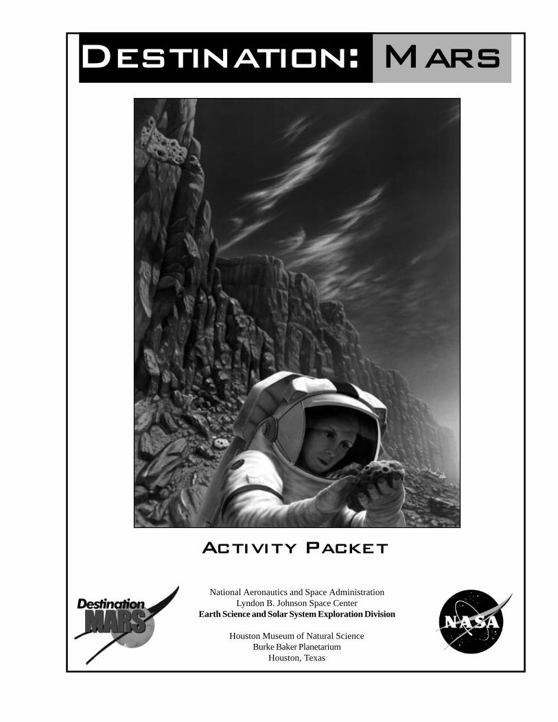
National Aeronautics and Space Administration Lyndon B. Johnson Space Center Earth Science and Solar System Exploration Division Houston Museum of Natural Science Burke Baker Planetarium Houston, Texas Activity Packet Destination: Mars
Transcript of Destination: Mars – Getting There! Navigation and Trajectory · PDF fileEarth Science...
National Aeronautics and Space AdministrationLyndon B. Johnson Space Center
Earth Science and Solar System Exploration Division
Houston Museum of Natural ScienceBurke Baker Planetarium
Houston, Texas
Activity Packet
Destination: Mars

2 Destination: Mars 10/97 NASA JSC
Contents
Lesson 1. Getting There — Navigationand Trajectory ............................................3
Lesson 2. Tricky Terrain — InvestigatingPlanetary Soils ......................................... 11
Lesson 3. Lava Layering — Making andMapping a Volcano .................................. 17
Lesson 4. Mapping Mars — GeologicSequence of Craters and RiverChannels .................................................. 27
Lesson 5. Searching for Life on Mars.................... 35Lesson 6. Why Do We Explore?.............................. 49Glossary ................................................................. 55Mars Fact Sheet........................................................ 56
The lessons are designed to increase students’knowledge, awareness, and curiosity about the processof scientific exploration of Mars. As scientists look forevidence of life on Mars, they will focus much of theirsearch in areas where volcanic heat and water interactedearly in the geologic history of the planet. Two lessonsin this packet on volcanoes and mapping river channelsreinforce these basic geologic processes. Theselessons lead directly to a set of simple activities thathelp students develop an understanding of the microbiallife scientists will be searching for on Mars. Thehands-on, interdisciplinary activities reinforce andextend important concepts within existing curricula.
AcknowledgementsThis activity packet was developed by teachers workingwith scientists at Johnson Space Center’s Earth Scienceand Solar System Exploration Division.
Marilyn M. Lindstrom Planetary Scientist, NASA JSC - Office of CuratorKathleen Mayse Teacher, Clear Creek ISD, Houston, TexasLinda Schrade Teacher, Clear Creek ISD, Houston, TexasKaren Stocco Teacher, Pasadena ISD, Pasadena, TexasKay Tobola Teacher, Clear Creek ISD, Houston, TexasCarlton C. Allen Planetary Scientist, Lockheed Martin
Jaclyn S. B. Allen Scientist/Ed. Specialist, Lockheed MartinAnita Dodson Graphic Design, Lockheed Martin
Educational VideoThe Destination: Mars educational video presents auseful parallel with the lessons. The 33 minute videochronicles a simulated human mission to Mars in 2018.The six astronauts narrate their exploration through “realtime” log reports. Destination: Mars is available as aneducational video from NASA CORE, Lorain County JointVocational School, 15181 Route 58 South, Oberlin, OH44074, (440) 774-1051, ext. 249 or 293, Fax (440) 774-2144. Itis also a multimedia planetarium program available fromSpitz Inc., P. O. Box 198, Route 1, Chadds Ford, PA 19317,contact John Schran (610) 459-5200, Fax (610) 459-8330.
InternetNASA Johnson Space Center, Office of the CuratorLunar Rocks and Antarctic Meteoriteshttp://www-curator.jsc.nasa.gov/curator/curator.htmContains educational material and information aboutrocks from space.
Lunar and Planetary Institutehttp://cass.jsc.nasa.gov/lpi.htmlContains educational material and Lunar and Marsimages.
NASA Jet Propulsion LaboratoryMars Global Surveyorhttp://mgswww.arc.nasa.gov/index.htmlMars Pathfinderhttp://www.mars.ucar.edu/default.html
About Destination: Mars

10/97 NASA JSC Destination: Mars 3
About This LessonIn Activity One students represent the orbital pathsof Earth and Mars through dramatic groupdemonstrations.
In Activity Two students working in pairs plot thepaths (trajectories) of a spacecraft travelingbetween Earth and Mars in the year 2018 andreturning in 2020. These paths use the minimumamount of fuel, and take about six months to flyfrom one planet to the other.
ObjectivesStudents will:
• consider the relationships of the planets asthey move around the Sun.
• consider expenditure of time/fuel forpayload in space travel.
• develop awareness of what actuallyhappens on minimum fuel orbits.
• plot the paths of spacecraft leaving Earthin 2018 for Mars and leaving Mars in 2020for Earth.
BackgroundMajor considerations for traveling to Mars are theamount of time the trip takes, the amount of fuelneeded for the trip, and the size of the payload. Afast trip would be advantageous to the crew byreducing the time they are exposed to weightless-ness, radiation, and other dangers inherent to spacetravel. However, fast trips require more fuel andthat means less payload. People, equipment, andsupplies would be reduced as larger amounts offuel are carried to increase the speed of the trip.
Earth and Mars move at different speeds aroundthe Sun. The Earth completes its solar orbit every365 days while Mars completes its orbit every 687days. This happens for two reasons. First, theEarth is closer to the Sun so it travels less distance.Secondly, it travels faster in its orbit. Planetscloser to the Sun travel faster.
Navigation and Trajectory
Lesson One Getting There!
Vocabularyorbit, trajectory
Activity One �
Dancing with thePlanets
Materialsq Student Procedure, Dancing with the
Planets (pg. 7), one per groupq costume and prop materials as needed
ProcedureAdvanced Preparation1. Read background and Student Procedure.
Research other sources of information asneeded.
2. Gather materials.3. Determine the time and space limitations
that will best fit the learning situation.Classroom Procedure1. Divide the class into groups of 4-6.2. Hand out the Student Procedure.3. Discuss the time and space limitations for
groups to consider in planning theirdramatic demonstrations. Encourage theuse of music, props, and choreography.
4. Allow adequate time for presentation anddiscussion of observations.
4 Destination: Mars 10/97 NASA JSC
4. Help students become familiar with thedata. Check for understanding. It isessential that students understand that Earthand Mars are moving and that the slasheson the Earth orbit represent the first of eachmonth.
5. Help students plot the first date —May 11, 2018.
Note: When plotting the distance from Sun point,the compass point is always put on the Sun;when plotting the distance from Earth, thecompass point is put in a different place eachtime. The point should be put on the slashmark that represents where the Earth will belocated on that date.
5. Make answer keys available to students sothey can check their work. If their orbitsare not similar to the answer key,encourage them to redo the procedures tofind their error.
6. Instruct students to apply the procedures toplot the return to Earth.
7. Closing discussion should encouragestudents to think about how a six monthflight effects planning trips to Mars.
More background information is contained inthe Destination: Mars Educational video. Seepg. 2 to order.
Activity Two �
Plotting the Pathsof Spacecraft
Materials❑❑❑❑❑ Student Procedure, Plotting the Paths
of Spacecraft (pg. 8)❑❑❑❑❑ Student Sheets, Earth to Mars and Mars
to Earth (pgs. 9-10)❑❑❑❑❑ pencils❑❑❑❑❑ drawing compass❑❑❑❑❑ Teacher Answer Key (pgs. 5-6)
ProcedureAdvanced Preparation1. Gather materials.2. Review background.3. Complete the plotting exercise for practice.Classroom Procedure1. Have students share familiar experiences
that require aiming at a moving target.Their examples might be passing a football,catching a fly ball, driving vehicles in pathsto avoid being hit, or playing dodge ball.Lead students to discuss the how and whyof the movements.
2. Have students work in pairs. They mayswitch jobs for each plotting exercise.
3. Hand out Student Procedure and StudentSheets.
Suggested Questions1. What are the orbital challenges of traveling from one planet to another?
2. What are some possible paths for a spacecraft traveling from Earth to Mars?
3. What could make a spacecraft get to Mars faster?
4. What are some of the problems considered by engineers and scientists as they design trips to Mars?

10/97 NASA JSC Destination: Mars 5
Earth to MarsTeacher Answer Key

6 Destination: Mars 10/97 NASA JSC
Mars to EarthTeacher Answer Key

10/97 NASA JSC Destination: Mars 7
Student Procedure
Dancing with the PlanetsStudent ProcedureAs scientists and engineers plan for travel toother planets, they have to deal with somebasic planetary science.
A Earth and Mars move at different speeds around the Sun.
A Earth’s orbit is about 150 million kilometers (km) from the Sun.
A Mars’ orbit is about 200 million km from the Sun.
A Earth completes a solar orbit every 365 days.
A Mars completes a solar orbit every 687 days. (The difference in orbit timesis about a 2 to 1 ratio Mars/Earth.)
A Earth completes its orbit in shorter time because it is closer to the Sun andhas less distance to travel.
A Earth travels faster in its orbit. Planets closer to the Sun travel faster.
Using these facts, demonstrate dramatically the movement of Earth and Mars aroundthe Sun. Incorporate music, costumes, and props in your demonstration for addedeffects. Your group may gather other information about Earth and Mars. Make yourpresentation scientifically accurate demonstrating as many facts as possible.

8 Destination: Mars 10/97 NASA JSC
AStudent Procedure
Plotting the Paths of Spacecraft
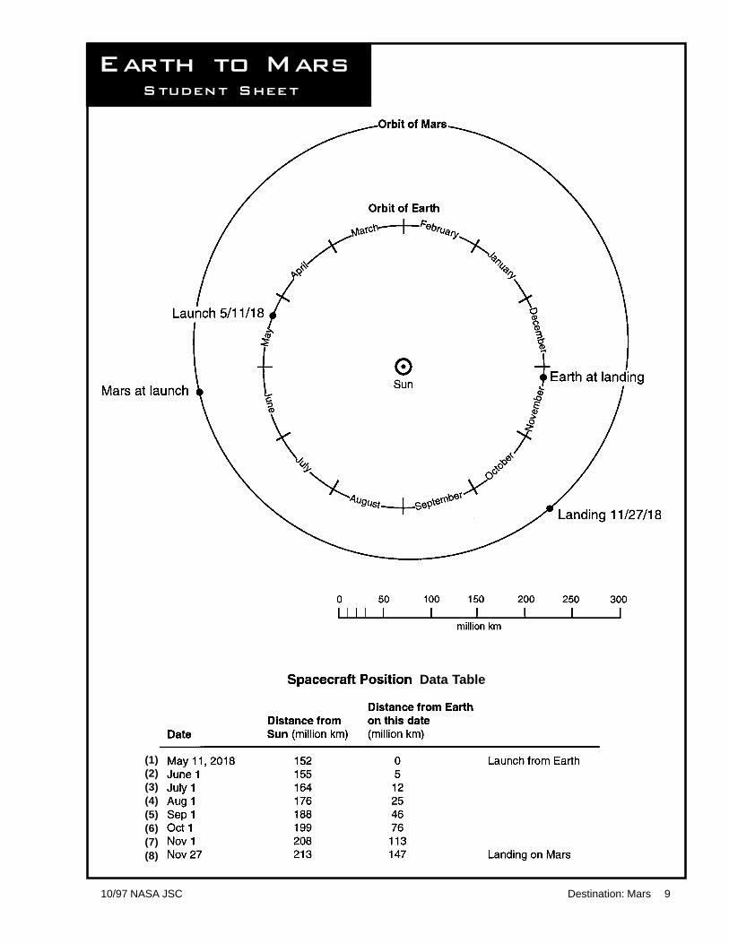
Student Procedure1. Locate the following on the Earth to Mars Student Sheet;
• Earth and Mars orbit paths• the Sun• Earth and Mars on launch date • the scale in millions of kilometers(km)• Earth and Mars on landing date • the location of Earth on the first of each month
2. Review the Spacecraft Position Data Table at the bottom of Earth to Mars Student Sheet.The Data Table shows the position of the spacecraft on the first day of each month.The first column is the distances of the spacecraft from the Sun in million km.The second column is the distances of the spacecraft from the Earth in million km.Note: Remember the Earth is moving. Each month it will be in a different place.
3. Plot the path (trajectory) of the spacecraft.a. Put the point of the compass on 0 on the scale and extend the angle until the pencil reaches
the first distance from Sun measurement given in the Data Table (152 million km). Pick upthe compass and place the point on the Sun in the diagram. Line the compass up with thefirst date given. Strike an arc.
b. Since the distance from Earth measurement is 0, the first point is where the distance fromthe Sun arc crosses Earth’s orbit.
c. Using the second set of data, measure the distance from the Sun (155 million km) on thescale with the compass. Place the compass point on the Sun and draw a circle. Measure thedistance from the Earth (5 million km) on the scale with the compass. Place the point ofthe compass on the June 1 slash mark and draw a circle. Notice that there are two pointswhere the circles intersect. Choose the intersection which is closest to the launchsite. This intersection represents the location of the spacecraft. Label location withthe date (June 1).
d. Repeat this process using each set of data. Each time, the intersection that is nearer thelaunch site represents where the spacecraft is located on that date.
e. Repeat these steps with each set of measurements on a given date.f. When all 8 points have been plotted, connect the points. This line is the path the spacecraft
will follow on its trip to Mars.4. Using the key, check that your line is similar to the model. If the two lines differ, find the
place in the process where the error occurred. Make sure you understand the process beforegoing to step 5.
5. Plot the trajectory of the return trip to Earth from Mars using the second diagram andData Table. Follow steps 1-4.
6. A minimum fuel trip between Earth and Mars takes about 200 days. Think about how thiseffects planning trips to Mars. Because of this long time in space, what must happen? Whatcannot happen? What might happen? These are the questions that mission planners mustanswer. What are other questions that might be asked about planning trips with minimum fuelorbits?
10/97 NASA JSC Destination: Mars 9
Earth to Mars
(1)(2)(3)(4)(5)(6)(7)(8)
Data Table
Student Sheet

10 Destination: Mars 10/97 NASA JSC
Mars to Earth
Data Table
(1)(2)(3)(4)(5)(6)(7)(8)
Student Sheet
10/97 NASA JSC Destination: Mars 11
Lesson Two Tricky Terrains
InvestigatingPlanetary Soils
About This LessonStudents working in teams will read paragraphsdescribing the soil samples and record informationon the appropriate chart. Students will then examineand test unknown soil samples and record testobservations. Using the charts, each unknownsample will be identified. Students will be asked todefend their decisions.
ObjectivesStudents will:
• extract pertinent information from writtensoil descriptions. They will organizeinformation using a fact chart.
• examine characteristics of three soils or soilsimulants.
• identify soils by matching the givendescriptions with their own observations ofthe soil properties.
• identify properties of soils from differentbodies in our solar system and notesimilarities and differences.
Background see Soil Information Sheet
Soil Samples1. Obtain Lunar and Mars simulants from Johnson
Space Center, Houston, Texas, 77058,Attention: Carl Allen C23. (Allow severalweeks. Simulants are free in small quantities.Cost of shipping is charged for larger quantities.)
2. Earth soil that is red or brownish orange can befound outdoors in many parts of the country.You will need to write your own description ifyou are not using a typical east Texas orange soil.
Vocabularyproperties, robotic, analyze, simulant, composition,meteorite, impact, organic, mare, texture
Materialsq Student Sheets, one each per group, Soil
Information Sheet, Chart of Known SoilData, and Chart of Unknown Soil Properties(pgs. 13-16)
q transparencies of the handouts (optional)q sets of 3 soil samples (1 set per group)
each set contains Mars simulant, Lunar simulant,Earth soil (in containers - bottles, vials, or jars)
q 1 magnet per group (Protect the magnet with thinpaper so that it is easier to remove fine particles.)
q 1 magnifier per groupq 1 metric ruler per group
ProcedureAdvanced Preparation1. Obtain soil simulants.2. Make copies of Student Sheets.3. Prepare sets of 3 soil samples. Label them
#1, #2, #3. Keep a record Sample Key.4. Assemble and distribute equipment per
Classroom Procedure.
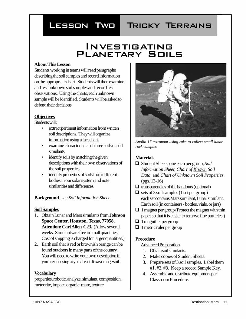
Apollo 17 astronaut using rake to collect small lunarrock samples.

12 Destination: Mars 10/97 NASA JSC
Classroom Procedure1. Divide the class into groups (3-4 per
group).2. Explain to the students that they are going to
be acting as real scientists. Scientists needto be very organized and often keep theirinformation in charts. Students will recorddata in chart form.
3. Hand out Soil Information Sheet and theChart of Known Soil Data. Have theclass or teacher read the introduction.Groups read the soil descriptionparagraphs and fill in the chart (10 to 20minutes).
4. Hand out the Chart of Unknown SoilProperties and the three unknown soilsamples. Direct students to examine thesamples and record their observations.Students should refer to the previouschart to aid their data collection onunknown samples.
5. Using the information from both charts,ask the students to decide which knownsample matches which unknown sample.Record the names at the bottom of theChart of Unknown Soil Properties.
6. Lead a discussion that examines thesimilarities and differences in the soilproperties.
• For some classes, comparing thesamples with the chart could be doneas a class.
• For more advanced students, thereasoning behind the choices could bedebated either verbally or in writing.
• Ask students to write their owndescription of the properties of adifferent soil sample, possibly samplesthey have provided.
Apollo astronaut collecting lunar rocks with tongs, on Apollo 12.

10/97 NASA JSC Destination: Mars 13
Human and robotictrips to the Moonhave returned a fewhundred kilograms ofrocks and soil.Spacecraft havelanded on the Marssurface and analyzedthe soil, but nosamples have beenreturned from the redplanet. In order tobecome betterprepared for futurevisits to both theMoon and Mars,scientists use theinformation alreadyknown about theseplanetary bodies.The informationhelped scientists findmaterial on Earth foruse as substitutes forthe Moon and Mars soils. Thesesubstitutes, called soil simulants, are usedto test equipment and techniques forfuture space exploration.
What is commonly called dirt is samplematerial for scientific studies. Scientistshave special ways to study soils.Scientists determine the composition ofthe soils by using advanced scientificequipment. Many kinds of soils form inour solar system. Data from instruments
Tricky TerrainSoil Information Sheet
on spacecraft helpscientists know moreabout the soils ofother planets.Everything in oursolar system formedfrom similarmaterials. Similarprocesses formedEarth and otherparts of our solarsystem. Therefore,scientists are able tofind soils on ourplanet that fairlyclosely match thesoils of the Moonand Mars.
Lunar soil iscomposed of rockthat has been brokenand melted bymeteorite impacts.
Mars soil is probably volcanic material,altered by contact with water. Earth soilis also the product of weathered rockminerals, but usually it also has organicmaterial from dead plants and animals.
• Read the descriptions onthe next pageand complete the“Chart of KnownSoil Data.” Payspecial attention to the wordsscientists use to describe thesoil materials.
Student Sheet
Top: Apollo 11 footprint on the Moon.Bottom: The surface of Mars taken from theViking Lander.

14 Destination: Mars 10/97 NASA JSC
JSC-1The Moon
JSC-1 is a powder madefrom crushed volcanic
ash. The ash erupted from a volcano inArizona. JSC-1 is uniformly dark gray incolor. Most of the powder is very fine,with an average size of 0.1 mm. The finestportion can be separated from the coarsermaterial by repeated shaking. The finermaterial looks slightly lighter gray than thecoarser material. Chunks larger than 1mm are generally masses of the finepowder, easily broken down withmoderate pressure. The powder containsa small percentage of material that can beseparated using a magnet. JSC-1 closelymatches the color, size, and compositionof soil in the mare areas of the Moon.
JSC Mars-1
JSC Mars-1 is a powdermade from weatheredvolcanic ash. The ash was
erupted from a volcano in Hawaii. JSCMars-1 is orange-yellow in color.
Individual particles are smaller than1 mm. The finest portion can beseparated from the coarser material byrepeated shaking. The finer portion isconsiderably more yellow than thecoarser material. The powder containsabout fifty percent dark material whichcan be separated using a magnet. JSCMars-1 closely matches the color andapproximates the size and compositionof soil in the bright areas of Mars.
Earth ET-1
Earth ET-1 is from PolkCounty in East Texas. Itis not volcanic. Earth
ET-1 is orange in color. Most particlesare bigger than 1 mm in size. The finestportion can be separated from the coarsermaterial by repeated shaking. There isno difference in color between the fineand coarse material. A very smallpercentage of the material can beseparated from the rest using a magnet.Some organic material may be present.Earth ET-1 is only one of many differentsoils on our planet.
Student Sheet

10/97 NASA JSC Destination: Mars 15
Tric
ky Terrain
�
C
hart of K
now
n S
oil
D
ata
Student S
heet

16 Destination: Mars 10/97 NASA JSC
Tric
ky Terrain
�
Chart of
Unknown S
oil
Propertie
sS
tudent S
heet

10/97 NASA JSC Destination: Mars 17
Making and Mappinga Volcano
Lesson Three Lava Layering
About This LessonThe focus of this activity is on the sequence oflava flows produced by multiple eruptions.Baking soda, vinegar, and play dough, are used tomodel fluid lava flows. Various colors of playdough identify different eruption events. Studentswill be asked to observe where the flows travel,make a model, and interpret the stratigraphy.
ObjectivesStudents will:
• construct a model volcano.• follow a procedure to produce a
sequence of lava flows.• observe, draw, record, and interpret the
history of the volcano.
BackgroundVolcanoes and/or lava flows are prominentfeatures on all large rocky planetary bodies. Evensome asteroid fragments show evidence of lavaflows. Volcanism is one of the major geologicprocesses in the solar system. Mars has a longhistory of volcanic activity from the ancientvolcanic areas of the southern highlands to themore recent major volcanoes of the Tharsis bulge.Olympus Mons is a volcanic mound over 20 kmabove the surrounding plains. This one volcanowould cover the entire state of Arizona!
Where volcanic heat and water interact here onEarth, scientists are finding life. In the hot springsof Yellowstone Park they have found abundant lifeforms including some very small bacteria. Thereis a possibility that life may have found a place inthe ancient volcanic terrain of Mars.
Some of the volcanoes on Mars are basalticshield volcanoes like Earth’s Hawaiian Islands.Interpretations of photographs and soil analysesfrom the Viking and Pathfinder missions indicatethat many of the lava flows on Mars are probablybasalt. Scientists believe that basalt is a verycommon rock type on all the large bodies of theinner solar system, including Earth.
Part 1�
Volcano ConstructionExperiments
(Original activity is from Exploring the Moon, a Teacher’s Guide with Activities for Earth and SpaceSciences, NASA Education Product EP-306 1994.)
Olympus Mons, a martian shield volcano, as seen by theViking Orbiter.

18 Destination: Mars 10/97 NASA JSC
In addition to shield volcanoes, there are dark, flatlayers of basaltic lava flows that cover most ofthe large basins of Mars and the Earth’s moon.The eruption sources for most of the basin lavaflows are difficult to identify because source areashave been buried by younger flows.
Generally, the overall slope of the surface, localtopographic relief (small cliffs and depressions),and eruption direction influence the path of lavaflows. Detailed maps of the geology of Mars andthe Moon from photographs reveal areas ofcomplicated lava layering. The study of rocklayering is called stratigraphy.
Older flows become covered by younger flowsand/or become more pocked with impact craters.Field geologists use differences in roughness,color, and chemistry to differentiate between lavaflows. Good orbital images allow them to followthe flow margins, channels, and levees to try totrace lava flows back to the source area.
Vocabularyeruption, source, stratigraphy, slope, layers
Materials Per Volcano Teamq 1 paper cup, 100 ml (4 oz.) size, cut
down to a height of 2.5 cmq 2 paper cups, 150-200 ml (6-8 oz.) sizeq cardboard, approximately 45 cm square
(other materials may be used: cookiesheet or box lid)
q playdough or soft clay — at least 4 fist-size balls, each a different color
q tapeq spoonq baking soda (4-10 spoonfuls depending
on number of flows)q vinegar, 100-150 ml (4-6 oz.) depending
on number and size of flowsq paper towelsq marker or grease pencilq paper and pencilq optional food coloring to color the vinegar
if desired, 4 colors; for example, red,yellow, blue, green
q Student Sheet, Lava Layering - Part 1(pgs. 19-20)
ProcedureAdvanced Preparation1. Review background information and
procedure.2 Gather materials.3. Prepare play dough using recipes
provided or purchase play dough.4. Cover flat work area with newspaper to
protect from spills.Classroom Procedure1. This activity may be done individually or
in cooperative teams. Groups of 2-4usually work well.
2. Follow procedure on Student Sheet,Lava Layering-Part 1.
3. Discuss the progression of flows, notingthat the youngest is on top and the oldestis on the bottom.
4. If Lava Layering Part 2 will be completedat a later time, be sure to cover thevolcanoes securely with plastic.
RecipesPlay Dough (stove-top recipe)Best texture and lasts for months when refriger-ated in an air tight container.
2 cups flour 1/3 cup oil, scant1 cup salt 2 cups cold water4 teaspoons cream of tartarfood colorings (20 drops more or less)
Make this large batch one color or divide ingredi-ents in half to make 2 colors. You will need 4colors total. Combine ingredients and cook mixturein a large sauce pan, stirring constantly, until thedough forms a ball. Turn dough out onto a flouredsurface to cool. Then kneed until smooth andelastic. Cool completely; refrigerate in air tightcontainers.
Play Dough (no-cooking recipe)2 cups flour 2 tablespoons oil1 cup salt 1 cup cold water6 teaspoons alum or cream of tartarfood colorings (as above)
Make this large batch one color or divide ingredi-ents in half to make 2 colors. You will need atleast 4 colors. Mix ingredients and kneed untilsmooth and elastic. Store in air tight containers.

10/97 NASA JSC Destination: Mars 19
Student Sheet
q vinegar, 100 ml (1/2 cup)q paper towelsq marker or grease pencilq paper and pencilq optional: food coloring to
color vinegar if desired.
Lava Layering � Part 1Materialsq 1 paper cup, 100 ml (4 oz.) size, cut down to a height
of 2.5 cmq 2 paper cups, 150-200 ml (6-8 oz.) sizeq cardboard or other surface, approx.
45 cm sq.q playdough or soft clay,
4 fist size balls, each a different color.q tapeq spoonq baking soda, 50 ml (1/4 cup)
Procedure1. Take one paper cup that has been cut to a height of 2.5 cm and secure it onto the cardboard.
(You may use a small loop of tape on the outside bottom of the cup.) This short cup is youreruption source and the cardboard is the original land surface.
2. Mark North, South, East, and West on the edges of the cardboard.3. Fill a large paper cup about half full with baking soda.4. Place one heaping spoonful of baking soda in the short cup.5. Pour vinegar into a large paper cup leaving it half full.
(optional: Fill 4 cups with 25 ml (1/8 cup) of vinegar. To each paper cup of vinegar add 3drops of food coloring; make each cup a different color to match playdough. Set them aside.)
6. Set aside 4 balls of playdough, each in a different color.7. You are now ready to create an eruption. Slowly pour a small amount of vinegar into your
source cup and watch the eruption of simulated lava.8. When the lava stops, quickly draw around the flow edge with a pencil or marker.9. Wipe up the fluid with paper towels.10. As best you can, use a thin layer of playdough to cover the entire area where lava flowed.
Exact placement is not necessary. Match flow color and playdough if available.11. On a separate sheet of paper record information about the flow. Indicate color, shape, direction
of flow, and thickness. Indicate where this flow is in the sequence; first, second, etc.12. Repeat steps 7 - 11 for each color of play dough available. Four to six flows show a good
example of a shield volcano.
NOTES: You may add fresh baking soda to the source cup or spoon out excess vinegar fromthe source cup as needed. Be sure you mark where the lava flows go over previous flows aswell as on the cardboard. Cover the entire area of each succeeding flow. This will resemble astrange layer cake with new flows overlapping old ones.
20 Destination: Mars 10/97 NASA JSC
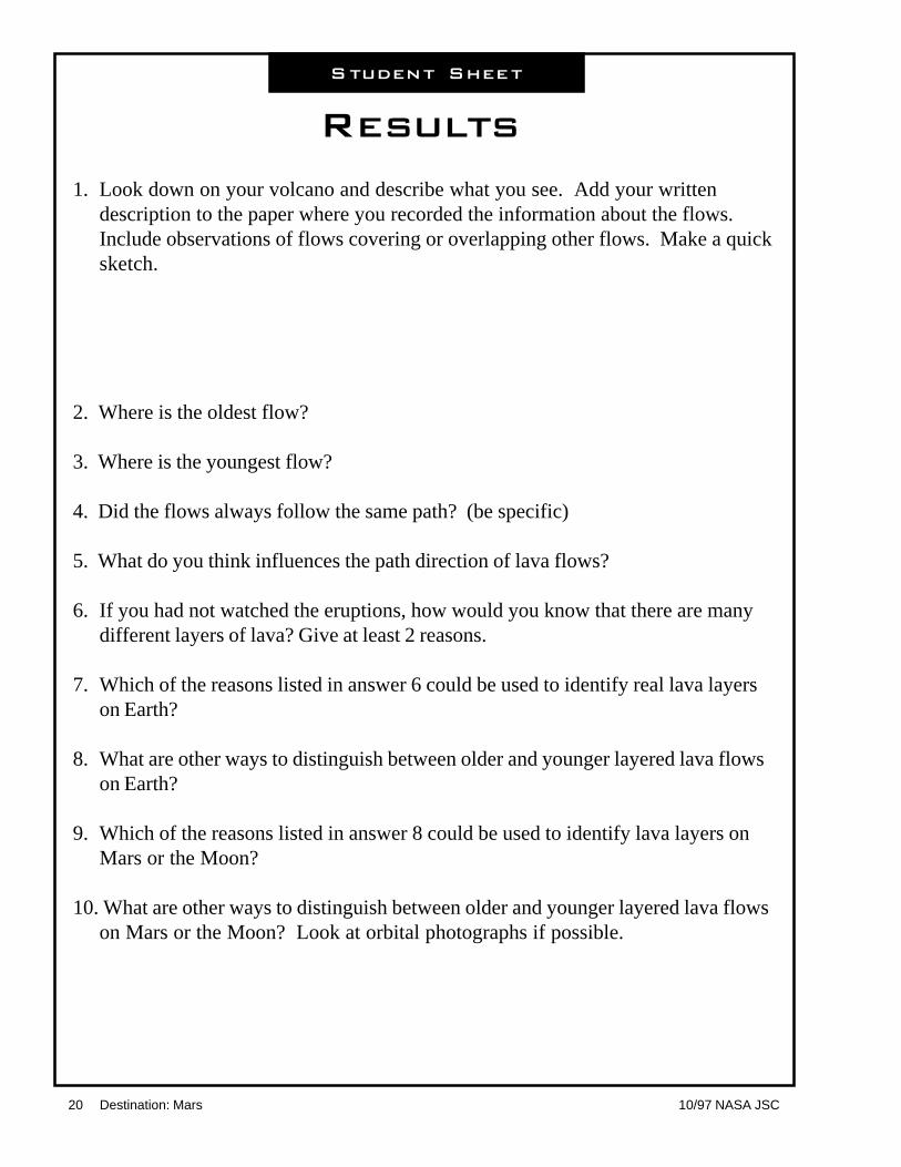
Results
1. Look down on your volcano and describe what you see. Add your writtendescription to the paper where you recorded the information about the flows.Include observations of flows covering or overlapping other flows. Make a quicksketch.
2. Where is the oldest flow?
3. Where is the youngest flow?
4. Did the flows always follow the same path? (be specific)
5. What do you think influences the path direction of lava flows?
6. If you had not watched the eruptions, how would you know that there are manydifferent layers of lava? Give at least 2 reasons.
7. Which of the reasons listed in answer 6 could be used to identify real lava layerson Earth?
8. What are other ways to distinguish between older and younger layered lava flowson Earth?
9. Which of the reasons listed in answer 8 could be used to identify lava layers onMars or the Moon?
10. What are other ways to distinguish between older and younger layered lava flowson Mars or the Moon? Look at orbital photographs if possible.
Student Sheet

10/97 NASA JSC Destination: Mars 21
About This Activity Students will simulate a mapping and fieldexercise. It is very similar to the first steps thatgeologists employ when they map and interpretthe geologic history of an area. Student teams willmap and study the volcanoes produced byanother team in Lava Layering, Part 1. LavaLayering, Part 2 is designed to promote the use ofhigher order thinking skills and encourages thequestioning, predicting, testing, and interpretingsequence that is important to scientific inquiry.
ObjectivesStudents will:
• produce a map of an unknown volcanoand show the sequence of lava flows.
• interpret the map data and infer thesubsurface extent of the flows.
• predict where excavations will give themost information.
• simulate both natural and humanexcavations.
• write a short geologic history of thevolcano.
BackgroundIn the solar system, volcanism is a major processactive now and in the past. All the large, solidinner solar system planetary bodies have surfacefeatures that have been interpreted as lava flowsand volcanoes. Mars has spectacular volcanoes.Where volcanic heat and water are close together,hot springs likely formed. These thermal springscould have harbored microbial life.
The thought processes and sequence of observ-ing, taking data, and interpreting that students usewhen completing this exercise are very similar tothe real investigations done by field geologists.
Photo geologists use pictures taken by planes andspacecraft to interpret the history of a planet’ssurface. If they can get to the surface, they dofield work by making maps and collectingsamples. Geologists used pictures taken fromMars orbit to interpret the history of the planet’ssurface. Soon there will be some new data toadd to the knowledge of Mars. The Mars GlobalSurveyor arrived at Mars in the fall of ‘97 and willreturn photos and other data about the surface ofMars. Pathfinder landed on July 4, 1997, andreturned valuable data on weather, rocks and soil.
Materialsq volcano made of playdough from Lava
Layering - Part 1, one volcano per teamq colored pencils or crayonsq metric rulers (two per group)q straight edge for cutting (dental floss and
wire cut playdough if knives are notpermissible)
q large width straws (one per group, or one5 cm-long piece per student.)
q Student Sheet, Lava Layering - Part 2(pgs. 25-26)
q toothpicks, 5-10 per volcano
ProcedureAdvanced Preparation1. Gather materials.2. Read procedure and background.3. Small groups of students assemble
volcanoes according to directions in LavaLayering- Part 1.
4. Mapping may be done immediately aftervolcano assembly or several days later.The playdough volcano must be coveredwith plastic if left more than a few hours.
5. Review map skills such as keys, scales,and measuring techniques.
Part 2�
Volcano MappingExtensions

22 Destination: Mars 10/97 NASA JSC
Classroom Procedure(This activity can easily be simplified as needed.)1. Have teams trade volcanoes so that they
will map a volcano with an “unknown”history. They may give the volcano aname if desired.
2. Ask groups to draw a map (birds-eyeview) of the volcano. This may be madein actual size or they may make a scaledrawing. The map should include a Northdirection arrow. An example drawn onthe board or overhead may be helpful ifstudents are not familiar with transferringmeasurements to a grid. Students willneed to make careful observations andmeasurements to map the volcanoesaccurately. Color and label the map.
3. Answer the questions on Student Sheet.Note: Some volcanoes may be morecomplex than others—each will bedifferent!! There may be flows that arecompletely covered, some flows that havetwo separate lobes, and some flows forwhich the sequential relationship can notbe determined at the surface.
4. Lead the students to question what theycannot see below the surface. Where dothe flows extend under the exposedsurface? Lead them to name ways theycan see what is below the surface withoutlifting the play dough. They may suggestdrill holes or cores, river erosion andbank exposure, earthquakes, or road cutsand other excavations.
5. Have groups make a plan that shows ontheir map where they want to put thesubsurface exposures. They shouldindicate how the proposed cores and cutswill maximize the information they mightgain from excavations. Limit the numberof exposures each group may use, i.e.,five drill cores and one road cut and oneriver erosion.
6. Make the cuts or cores.• Remove drill core by pushing a straw
vertically into the playdough, twistingif necessary, and withdrawing thestraw. Blow through the open end ofthe straw to remove the core. Put thecore on a toothpick and place it bythe hole for reference.
• River valleys may be made by cuttingand removing a “v” shape in the sideof the volcano (open part of “v”facing down slope).
• To make road cuts, use knife ordental floss to cut and remove a stripabout 1 cm wide and as deep as youwant from any part of the volcano.
• To make earthquake exposures,make a single cut and lift or drop oneside of the fault line. Some supportwill be necessary.
7. Record cuts and cores on the map and innotes. Be sure to use locationinformation, i.e., core # 2 is located onthe blue flow in the Northeast quadrant ofthe volcano.
8. Observe hidden layers. Interpret dataand draw dotted lines on the mapindicating the approximate or inferredboundaries of the subsurface flows.
9. On a separate paper, write a short historyof the volcano that relates sequence offlows and relative volumes of flows (ormake a geologic column, a map key tothe history that shows oldest geologicactivity at the bottom and youngest at thetop). Math classes may try to figure thevolume of the various flows.
10. Compare the history developed bymapping in Part 2 with the original historyfrom the group that made the volcano inPart 1. Write how they are similar ordifferent.
11. Conduct debriefings at several stages ofthis activity.

10/97 NASA JSC Destination: Mars 23
CentralCrater(cup)
play doughflows
Example of bird’s eye view map of lava flows.
cardboard or flat surface
N

24 Destination: Mars 10/97 NASA JSC

10/97 NASA JSC Destination: Mars 25
Student Sheet
Lava Layering � Part 2DirectionsMake a map of a volcano model. Do this from a birds eye view. Label flows andfeatures.
1. How many flows can you see on your map?
2. Beside the map make a list of the lava flows, starting with the youngest flow at thetop and finishing with the oldest flow at the bottom. Example: Top flow is a long,skinny, green flow.
3. Can you easily determine the sequence of flows (which came first, which camelast) or are there some flows where you can’t say which are younger or older?Put a question mark by the uncertain flows in the list on the map.
4. Are there parts of any flows that might be covered? Which ones?
5. What would you need to tell the sequence and shape of each flow? How couldyou get that information without lifting the playdough?
6. Think about what techniques will help you learn more about the interior of yourvolcano. Your teacher will lead a class discussion about these techniques beforeyou experiment. Stop here and wait for the teacher to continue.

26 Destination: Mars 10/97 NASA JSC
7. Document why each proposed experiment will be helpful in revealing informationabout your volcano. Conduct the experiments and record locations and theinformation gained.
8. Finish your map. On a piece of paper, write a description of the sequence thattells the history of the volcano. Compare your sequence to the history written bythe group that originally made the volcano. Was your interpretation accurate?Explain.
9. Why would it be harder to map lava flows on Mars using spacecraft photos?

10/97 NASA JSC Destination: Mars 27
Geologic Sequence ofCraters and River Channels
Lesson Four Mapping Mars
About This LessonStudents will approach studying the surface ofMars in the same way as photogeologists. Afterdrawing a simple features map, they will have thetools to state the general geologic history of a partof Mar’s surface. Students focus on the evidenceshowing river channels that once flowed andcaused erosion. The evidence for water andvolcanoes (see Lava Layering) on Mars points topossible environments where life could haveexisted.
ObjectivesStudents will:
• observe photographic details.• make a simple features map.• interpret the geologic history of a part of
Mars’ surface.• analyze and discuss sequencing.
BackgroundScientists use maps to illustrate the geologichistory of a planet or moon. Geologic maps showpresent day features and evidence of past events.The maps show features that were formed earlieror later than others, giving scientists a relative timesequence of events (not precise dates). On Earththese maps are made using photographs takenfrom airplanes and spacecraft, and from researchon the Earth’s surface. To make maps of otherplanets we must use photographs taken byspacecraft and use lander information from theplanet’s surface.
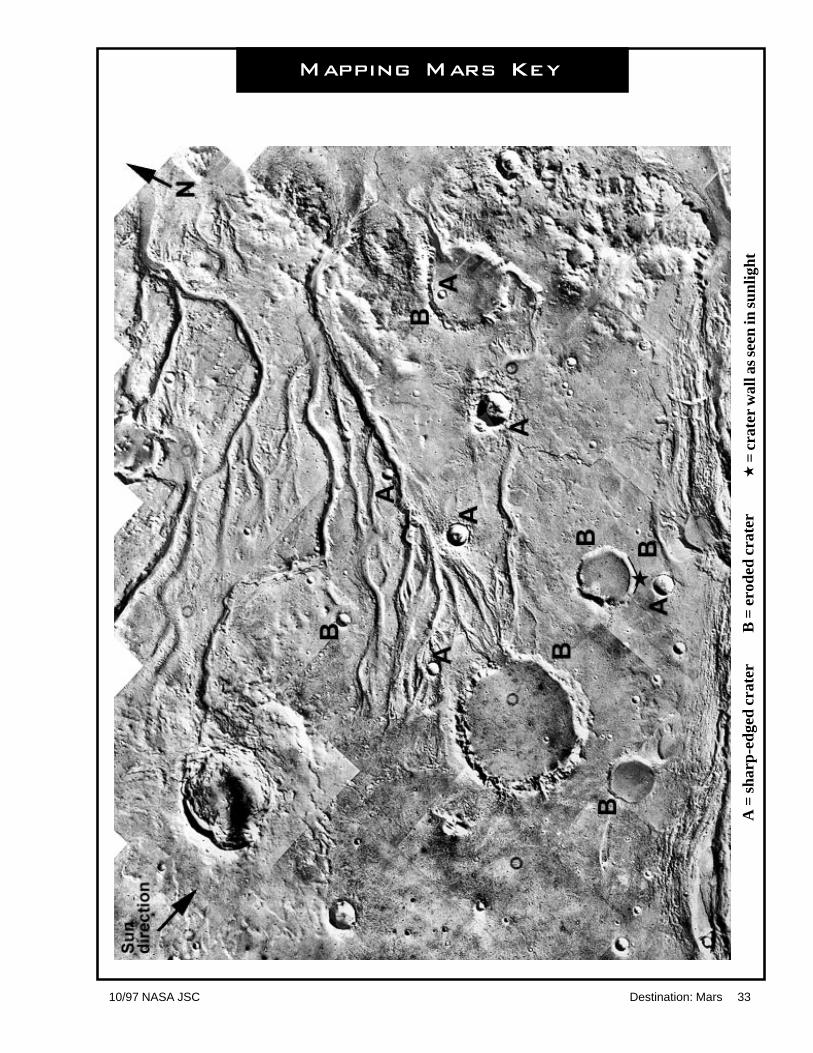
Vocabularycrater, ejecta, eroded, channel, sun angle,sequence, Chryse Planitia (cry´ see plän i´ ti )
Materials - For activity using paper photosq photo of Mars surface showing outflow
channels emptying into northern plains ofChryse Planitia. Photo available on theWorld Wide Web at:
http://cass.jsc.nasa.gov/expmars/channels.html
q Student Sheet, Mars Mapping (pg. 31)q tracing paper or transparencies, one per
paper photoq tape or paper clipsq colored markers (3 colors - red, green,
and blue are used in the discussion below)
Materials - For group version using slideq slide projectorq large sheet of paper (not shiny) or a
non-shiny erasable white board may beused — test first
q masking tapeq slide of Mars surface showing outflow
channels emptying into northern plains ofChryse Planitia. Slide # 25“Outflow Channels Emptying intoNorthern Plains of Chryse Planitia”in the Set THE RED PLANET:A SURVEY OF MARS
Order DepartmentLunar and Planetary Institute3600 Bay Area BoulevardHouston TX 77058-1113Phone: (281) 486-2172Fax: (281) 486-2186e-mail: [email protected]
Note: A high quality transparency from a photodeveloper works well. Use the slide to make thetransparency. Project with classroom overheadprojector.
e

28 Destination: Mars 10/97 NASA JSC
ProcedureAdvanced Preparation1. Gather materials.2. Become familiar with the important
features in the Mars photo.3. Practice determining the up and down
slopes of the features by paying attentionto the Sun illumination angle and theshadows on the features.
Procedure for Paper Copy of PhotographSteps below are for individuals or pairsusing a paper copy of the Mars image.1. Secure a transparency or sheet of tracing
paper to the top of the Mars photo.2. Distribute materials.3. Tell students that this is a spacecraft
photograph of an area on Mars around20º N latitude and 55º W longitude, at thenorthern edge of Chryse Planitia. Theimage shows impact craters and riverchannels. The area is about 200 kilome-ters across. No one has ever been there,but we can figure out things about thispart of Mars by mapping and thinking.
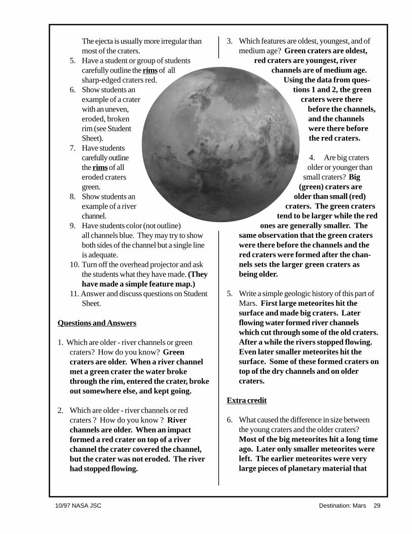
4. Show students an example of a craterwith a continuous, sharp-edged, unbrokenrim. Note that they should draw the rimand not the fairly flat interior (see drawingon student sheet).If time and skill allow, students may alsonote and draw the ejecta for the freshsharp rimmed craters. The ejecta is thematerial that is blasted out of the craterand falls outside the rim of the crater. Theejecta is usually more irregular than mostof the craters. Review with studentshow to tell what is a depression andwhat is a hill slope by knowing thedirection of illumination from the Sun.
5. Have students carefully outline the rims ofall sharp-edged craters red.
6. Show students an example of a craterwith an uneven, eroded, broken rim (seestudent sheet).
7. Have students carefully outline the rims ofall eroded craters green.
8. Show students an example of a riverchannel.
9. Have students color (not outline) allchannels blue. They may try to showboth sides of the channel but a single linein the middle of the channel is adequate.
10. Have students lift the transparencies andlook at them. Ask the student what theyhave made. (They have made a simplefeature map.)
11. Answer and discuss the questions onStudent Sheet.
Group Procedure Using a SlideSteps below are for a large group activityusing a slide.1. Tape a large sheet of paper to the wall.2. Project the slide on the paper, so the
image is as large as possible.Be aware that it will be easier to clearlydistinguish details on the image fromseveral feet away due to projectorfocusing. When students draw on thepaper they will either need to ask forsome help from classmates or step backfrequently. This leads to a goodcooperative activity.
3. Tell students that this is a spacecraftphotograph of an area on Mars around20º N latitude and 55º W longitude, at thenorthern edge of Chryse Planitia. Theimage shows impact craters and riverchannels. The area is about 200 kilome-ters across. No one has ever been there,but we can figure out things about thispart of Mars by mapping and thinking.
4. Show students an example of a craterwith a continuous, sharp-edged, unbrokenrim. Note that they should draw the rimand not the fairly flat interior (see drawingon student sheet).If time and skill allow, students may alsonote and draw the ejecta for the freshsharp rimmed craters. The ejecta is thematerial that is blasted out of the craterand falls outside the rim of the crater.
10/97 NASA JSC Destination: Mars 29
The ejecta is usually more irregular thanmost of the craters.
5. Have a student or group of studentscarefully outline the rims of allsharp-edged craters red.
6. Show students anexample of a craterwith an uneven,eroded, brokenrim (see StudentSheet).
7. Have studentscarefully outlinethe rims of alleroded cratersgreen.
8. Show students anexample of a riverchannel.
9. Have students color (not outline)all channels blue. They may try to showboth sides of the channel but a single lineis adequate.
10. Turn off the overhead projector and askthe students what they have made. (Theyhave made a simple feature map.)
11. Answer and discuss questions on StudentSheet.
Questions and Answers
1. Which are older - river channels or greencraters? How do you know? Greencraters are older. When a river channelmet a green crater the water brokethrough the rim, entered the crater, brokeout somewhere else, and kept going.
2. Which are older - river channels or redcraters ? How do you know ? Riverchannels are older. When an impactformed a red crater on top of a riverchannel the crater covered the channel,but the crater was not eroded. The riverhad stopped flowing.
3. Which features are oldest, youngest, and ofmedium age? Green craters are oldest,
red craters are youngest, riverchannels are of medium age.
Using the data from ques-tions 1 and 2, the green
craters were therebefore the channels,and the channelswere there beforethe red craters.
4. Are big cratersolder or younger than
small craters? Big(green) craters are
older than small (red)craters. The green craters
tend to be larger while the redones are generally smaller. The
same observation that the green craterswere there before the channels and thered craters were formed after the chan-nels sets the larger green craters asbeing older.
5. Write a simple geologic history of this part ofMars. First large meteorites hit thesurface and made big craters. Laterflowing water formed river channelswhich cut through some of the old craters.After a while the rivers stopped flowing.Even later smaller meteorites hit thesurface. Some of these formed craters ontop of the dry channels and on oldercraters.
Extra credit
6. What caused the difference in size betweenthe young craters and the older craters?Most of the big meteorites hit a long timeago. Later only smaller meteorites wereleft. The earlier meteorites were verylarge pieces of planetary material that

30 Destination: Mars 10/97 NASA JSC
were still being pulled together throughthe process of solar system accretion(gathering of material into planetarybodies). As time passed, the impactswere caused by the smaller pieces ofmaterial leftover from the accretionprocess, thus making smaller craters.
7. Which way does the land slope? The landslopes downwards from the west to theeast. River channels combine as you godownhill. A map of the Mississippi Riveror some other terrestrial river basin maybe used as a comparison. These Marschannels do not show a delta formation assome may suggest.
ejecta
crater rim
floor and sidesof crater
erodedcrater rim
flowchannels
craterfloor
outer craterslope

10/97 NASA JSC Destination: Mars 31
Mars Mapping
Objective
To make a simple features map and interpret the geologic history of a part of Mars’
surface.
Background
Scientists use maps to illustrate the geologic history of a planet or moon. Geologic
maps show present day features and evidence of past events. The maps show
features that were formed earlier or later than others, giving scientists a relative time
sequence of events, although not precise dates. On Earth these maps are made using
photographs taken from airplanes and spacecraft, and from research on the Earth’s
surface. To make maps of other planets we must use photographs taken by
spacecraft and use lander information from the planet’s surface.
The area in the photograph of Mars is about 200 kilometers across and shows
impact craters and river channels. Mark these features on the photograph using the
examples below. Then answer the questions on the back of this page.
Features found in the photograph are:
1. Craters with continuous, sharp-edged, unbroken rims.
Carefully outline the rims all such craters Red.
2. Craters with uneven, eroded, broken rims.
Carefully outline the rims of all such craters Green
3. River channels.
Color (not outline) all channels Blue.
Student Sheet
ejecta
crater rim
floor and sidesof crater
erodedcrater rim
flowchannels
craterfloor
outer craterslope

32 Destination: Mars 10/97 NASA JSC
QuestionsUse the map to answer the questions.
1. Which are older — river channels or green craters? How do you know?
2. Which are older — river channels or red craters? How do you know?
3. Which features are oldest, youngest, and of medium age?
4. Are big craters older or younger than small craters?
5. Write a simple geologic history of this part of Mars.
Challenge
What caused the difference in size between the young craters and the older craters?
Which way does the land slope?
10/97 NASA JSC Destination: Mars 33
A =
sha
rp-e
dged
cra
ter
B =
ero
ded
crat
er
Mapping Mars Key
«=
cra
ter w
all a
s se
en in
sun
light

34 Destination: Mars 10/97 NASA JSC

10/97 NASA JSC Destination: Mars 35
Lesson Five Searching forLife on Mars
This lesson contains four exercises within three activities. The activities have been grouped to encouragestudents to think about the characteristics of life and about the possibility of looking for life on Mars.
Activity 1 — Imaginary MartiansStudents will listen to one or more excerpts from science fiction that describe a fictional livingorganism from Mars. They will then draw their interpretations of the creatures and compare them towhat they already know about life on Mars today.
Activity 2 — Looking for LifePart A: An Operational Definition of Life Students will research characteristics of living organisms anddevelop a chart that will help them define important features of a living organism.Part B: It’s Alive! They will then use their definition to determine whether there is anything alive inthree different soil samples, an experiment similar to the Mars Viking Lander in 1976 that looked forsigns of life. Students will record their observations and draw pictures as they collect data from thesamples.
Activity 3 — Mars CrittersStudents will design a plant or animal life form that might survive on Mars.
Activity 1�
Imaginary Martians
About This ActivityStudents will listen to one or more excerpts fromscience fiction that will describe fictional livingorganisms from Mars. They will then draw theirinterpretations and compare them to what theyalready know about life on Mars today.
ObjectivesStudents will:
• draw their interpretation of a Martian afterlistening to a science fiction reading.
• analyze the realism of this Martian basedon today’s knowledge of Marsenvironment.
• discuss the popularity of Mars inliterature.
36 Destination: Mars 10/97 NASA JSC
BackgroundThere are many science fiction stories related toMars. Each one has its own explanation of how aMartian might look. The descriptions are basedon the author’s imagination and the knowninformation about Mars from the time period. Inthis interdisciplinary activity, students will interpretan author’s description of a Martian (languagearts and art) and evaluate the possibility of such acreature living on Mars (science).
Vocabularyinterpretation, atmosphere, radiation
Materialsq drawing paperq coloring utensilsq Student Sheet, If You Went to Mars
(pg. 37)q excerpts from science fiction novels
Examples are Mars by Ben Bova(chapter 7), Out of the Silent Planet byC. S. Lewis (chapter 7), The MartianChronicles by Ray Bradbury (February1999-YUa), The Day The MartiansCame by Frederick Pohl (chapter 17)
ProcedureAdvanced Preparation1. Check various novels and choose
excerpt(s) to use.2. Practice reading the excerpt(s).3. Distribute student supplies.4. Distribute the If You Went to Mars
student sheet.Classroom Procedure1. Explain to the students that people in the
past have had very different ideas of what
life is like on Mars and that you wouldlike to share some of these interpretationswith them.
2. Ask the class to close their eyes and listento the reading(s).
3. Read the excerpt(s) with animation andsound effects.
4. Tell the students to open their eyes, takethe drawing materials of their choice, anddraw what they think the author(s)described.
5. Ask the students why they think theauthor wrote the descriptions in this way.Discuss answers in terms of the literatureand the time when the story was written.
6. Ask the students why they think there isso much literature about the planet Mars?
7. Ask each student to explain why the aliendrawn could or could not really be foundon Mars.
8. Discuss what it would be like to live onMars. Use the If You Went to Marsstudent sheet.
Alternatives1. Instead of a standard sheet of paper, have
the students work in groups using a largesheet of butcher paper. Then you canalso discuss how differently we eachinterpret what we hear. Display art.
2. Divide the class into teams and readseveral different excerpts, each teamdrawing an interpretation of a separateexcerpt, then comparing the teamdrawings. Display art.

10/97 NASA JSC Destination: Mars 37
If You Went to Marsfrom “Guide to the Solar System,”by The University of Texas, McDonald Observatory
Mars is more like Earth than any other planet in our solar system but is still
very different. You would have to wear a space suit to provide air and to
protect you from the Sun’s rays because the planet’s thin atmosphere does
not block harmful solar radiation. Your space suit would also protect you
from the bitter cold; temperatures on Mars rarely climb above
freezing, and they can plummet to -129ºC (200 degrees below zero
Fahrenheit). You would need to bring water with you; although if you
brought the proper equipment, you could probably get some Martian
water from the air or the ground.
The Martian surface is dusty and red, and huge duststorms occasionally
sweep over the plains, darkening the entire planet for days. Instead of a
blue sky, a dusty pink sky would hang over you.
Student Sheet

38 Destination: Mars 10/97 NASA JSC
Fundamental Criteriafor Life Chart
Fill in Criteria after the class has made observations and the teacher has grouped theobservations.
LivingOrganism Criteria Criteria Criteria Criteria Criteria
Student Sheet
10/97 NASA JSC Destination: Mars 39
Activity 2�
Looking for Life
About This ActivityIn Activity A students will use research to developtheir criteria for life. The class will combine theirideas in a teacher-guided discussion. In ActivityB they will then use their definition of life todetermine whether there is anything alive in threedifferent soil samples. They will makeobservations and draw pictures as they collectdata from the samples and experiment.
ObjectivesStudents will:
• form an operational definition of life.• conduct a simulated experiment with soil
samples similar to the experiments on theMars Viking Lander.
• state relationships between the soilsamples using their operationaldefinition of life.
• make an inference about the possibility oflife on Mars based on data obtained.
BackgroundWe usually recognize something as being alive ornot alive. But when scientists study very smallsamples or very old fossilized materials, the signsof life or previous life are not easy to determine.Scientists must establish criteria to work with intheir research. The tests for life used by the VikingMars missions were based on the idea that lifewould cause changes in the air or soil in the sameway that Earth life does. The Viking tests did notdetect the presence of life on Mars. The Vikingtests would not have detected fossil evidence ofpast Mars life or a life form that is verydifferent from Earth life.
Vocabularycriteria, characteristics, organism, replication,metabolic
Part A:An OperationalDefinition of Life
About This PartStudents will conduct research to identifycharacteristics of living and non-living organisms.They will record their observations on a chart thatwill help the class to come to a consensus abouthow to identify living things.
Materialsq Student Sheet Fundamental Criteria for
Life Chart (pg. 38)q dictionaries and encyclopediasq examples of living and non-living things
(should include plants, animals, andmicroorganisms—pictures can besubstituted for the real thing)
ProcedureAdvanced Preparation1. Gather materials.2. Review Background and Procedure.
Classroom Procedure1. Explain to students that their job is to
come up with a definition of how livingthings can be detected.
2. Ask students to state (or write) whatcharacteristics make an individual itemalive or not alive. Encourage them tofind pictures and definitions of living andnon-living things. Allow the students useof dictionaries and encyclopedias. Usethe examples on the following page toencourage the students but not to limitthem.
Example: Consider a bear and a chair—they both have legs, but one can move on itsown and the other would need a motor madeby humans; therefore, independent movementmight be one characteristic that indicates life.

40 Destination: Mars 10/97 NASA JSC
Not every living organism needs legs or roots.But they do need a mode of locomotion or away to get nutrients. Also, the bear breathesand the chair does not, another indication oflife. Or consider a tree and a light pole. Weknow that a light pole can not reproduce— itis made by humans—and we know that thetree makes seeds that may produce moretrees. The tree also takes in nutrients andgives off gasses and grows. The light useselectricity and gives off light, but it is strictly anenergy exchange and there is no growth andthere are no metabolic processes.
However, students might not list thefundamental criteria for life. They might go forthe more obvious signs like methods oflocomotion. The more subtle but fundamentalsigns of life are:
• metabolic processes that showchemical exchanges which may bedetected in some sort of respiration orexchange of gases or solid materials.
• some type of reproduction, replicationor cell division.
• growth.• reaction to stimuli.
3. As a class, discuss the indications of life,asking for examples from a diversesampling of living things. The teacher willparaphrase and group criteria on theblank chart, then guide the students tosummarize the groupings to reflect thefundamental criteria for life.
4. Students will use these criteria for thefollowing activities.
Part B: It�s Alive!
About This PartStudents will take three different soil samples andlook for signs of life based on the criteria fromPart A.
Materialsq sand or sandy soil sampleq three glass vials, baby food jars, or
beakers for soil per groupq sugar- 5 ml (sugar will be added to all
soil samples)q instant active dry yeast- 5 ml added to 50
ml of soilq Alka-Seltzer tablets crushed- 1 tablet
added to 50 ml of soilq hot water - enough to cover the top of the
soil in all jars (not hot enough to kill theyeast!)
q cups for distributing the waterq magnifying lens- 1 per group or
individualq Student Sheets Data Chart I and Data
Chart II (pgs. 43-44)
ProcedureAdvanced Preparation1. Fill all jars 1/4th full of soil. (You will need
3 jars per team.)2. Add just sugar to 1/3rd of the jars. Label
these jars “A.”3. Add instant active dry yeast and sugar to
1/3rd of the jars. Label these jars “B.”4. Add the powdered Alka-seltzer and
sugar to the remaining jars. Label thesejars “C.”
5. Give each group a set of three jars,magnifying lens, and the chart fromprevious activity.
10/97 NASA JSC Destination: Mars 41
Classroom Procedure(Information for teacher only— do not shareall the information with students!)1. Explain to the students that each team has
been given a set of soil samples. No oneknows if there is anything alive in them.The assignment is to make carefulobservations and check for indications ofliving material in them — based on theircriteria.
2. Ask students to observe all three samples.They can smell and touch the samples butnot taste them. Encourage students to puta few grains on a flat white surface andobserve them with a hand lens. Studentsshould then record their data.
3. Give each group a cup of water. (Use hottap water (~50ºC) for the best results, donot kill the yeast.) Ask students to pourthe water so that each sample is coveredwith the water.
4. Repeat step 2 and record data on asecond sheet or in a separate area of thefirst sheet. Students should look for andrecord differences caused by addingwater. After recording the firstobservations have students go back andobserve again. (After about ten minutesSample B will show even more activity.)
5. Discuss which samples showed
indication of activity (B and C).Does that activity mean there is life in bothB and C and no life in Sample A?Are there other explanations for theactivity in either B or C?
• Both B and C are chemical reactions• Sample C reaction stops• Sample B sustains long term activity• Sample A is a simple physical change where sugar dissolves
Students should realize that there could beother tests that would detect life inSample B. There might be microbes inthe soil that would grow on a culturemedium.
6. Determine which sample(s) contain life byapplying the fundamental criteria forindicating life developed in Activity 2.
7. Tell students that Sample B containedyeast and Sample C contained AlkaSeltzer. Discuss how scientists could tellthe difference between a non-livingchemical change (Alka Seltzer) and a lifeprocess (yeast) which is also a chemicalchange.
8. Discuss which of their criteria wouldidentify yeast as living and Alka Seltzer asnon-living.

42 Destination: Mars 10/97 NASA JSC

10/97 NASA JSC Destination: Mars 43
It�s Alive! Data Chart I
Initial Descriptions (no water added):
Sample A:
Sample B:
Sample C:
Initial Drawings (no water added):
Sample A
Student Sheet
Sample B
Sample C

44 Destination: Mars 10/97 NASA JSC
It�s Alive! Data Chart II
Initial Descriptions (after water is added):
Sample A:
Sample B:
Sample C:
Initial Drawings (after water is added):
Sample C
Student Sheet
Sample A Sample B
10/97 NASA JSC Destination: Mars 45
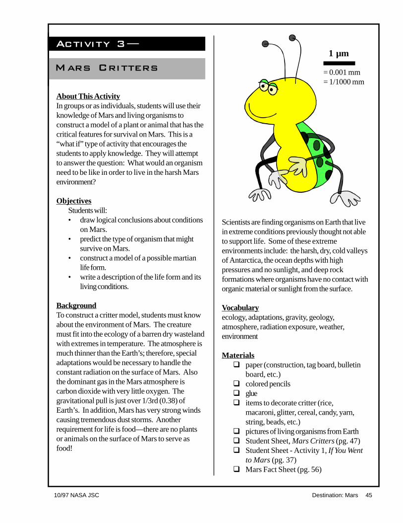
Activity 3�
Mars Critters
About This ActivityIn groups or as individuals, students will use theirknowledge of Mars and living organisms toconstruct a model of a plant or animal that has thecritical features for survival on Mars. This is a“what if” type of activity that encourages thestudents to apply knowledge. They will attemptto answer the question: What would an organismneed to be like in order to live in the harsh Marsenvironment?
ObjectivesStudents will:• draw logical conclusions about conditions
on Mars.• predict the type of organism that might
survive on Mars.• construct a model of a possible martian
life form.• write a description of the life form and its
living conditions.
BackgroundTo construct a critter model, students must knowabout the environment of Mars. The creaturemust fit into the ecology of a barren dry wastelandwith extremes in temperature. The atmosphere ismuch thinner than the Earth’s; therefore, specialadaptations would be necessary to handle theconstant radiation on the surface of Mars. Alsothe dominant gas in the Mars atmosphere iscarbon dioxide with very little oxygen. Thegravitational pull is just over 1/3rd (0.38) ofEarth’s. In addition, Mars has very strong windscausing tremendous dust storms. Anotherrequirement for life is food—there are no plantsor animals on the surface of Mars to serve asfood!
Scientists are finding organisms on Earth that livein extreme conditions previously thought not ableto support life. Some of these extremeenvironments include: the harsh, dry, cold valleysof Antarctica, the ocean depths with highpressures and no sunlight, and deep rockformations where organisms have no contact withorganic material or sunlight from the surface.
Vocabularyecology, adaptations, gravity, geology,atmosphere, radiation exposure, weather,environment
Materialsq paper (construction, tag board, bulletin
board, etc.)q colored pencilsq glueq items to decorate critter (rice,
macaroni, glitter, cereal, candy, yarn,string, beads, etc.)
q pictures of living organisms from Earthq Student Sheet, Mars Critters (pg. 47)q Student Sheet - Activity 1, If You Went
to Mars (pg. 37)q Mars Fact Sheet (pg. 56)
1 µm
= 0.001 mm= 1/1000 mm

46 Destination: Mars 10/97 NASA JSC
ProcedureAdvanced Preparation1. Gather materials.2. Set up various art supplies at each table
for either individual work or small groupwork. This activity may be used as ahomework project.
3. Review the “If You Went to Mars” sheet,Mars Fact Sheet, and the backgroundprovided above. Other research andreading may be assigned as desired.
Classroom Procedure1. Ask students to work in groups to
construct a model of an animal or plantthat has features that might allow it to liveon or near the surface of Mars. Havethem consider all the special adaptationsthey see in animals and plants here onEarth. They must use their knowledge ofconditions on Mars, consulting the MarsFact Sheet, If You Went to Mars, andother resources such as web pages ifnecessary. Some key words for a web
search might be “life in space” or“extremophile” (organisms living inextreme environments). They mustidentify a specific set of conditions underwhich this organism might live. Encouragethe students to use creativity andimagination in their descriptions andmodels.
2. If this is assigned as homework, provideeach student with a set of rules and agrading sheet, or read the rules andgrading criteria aloud and post a copy.
3. Review the information already learnedabout Mars in previous lessons.
4. Allow at least 2 class periods for thisproject: one for construction, one forpresentation.
5. Remind the students that there are nowrong critters as long as the gradingcriteria are followed.
6. Include a scale with each livingorganism.

10/97 NASA JSC Destination: Mars 47
MARS CRITTERSIn order to better understand what types of life scientists will look for when they goto Mars, you will construct a model or draw a picture of an organism that hasfeatures that might allow it to live on or near the surface of Mars.
Conduct research about the environment on Mars. Consider the geology, gravity,atmosphere, radiation exposure, and weather. Choose a habitat somewhere in theMars environment for the organism to live. Then construct a model of the plant oranimal and include the special features it would need to live in that harsh environment.You may want to research the special adaptations animals and plants have to survivein difficult places here on Earth. Be creative and use your imagination.
Make a scale model or picture of your critter. Answer all the questions on the nextpage and attach them to the picture or model of your critter.
GRADING1. Your entry will be graded on scientific
accuracy (40%) and creativity (40%).Remember that everything on Marsmust obey the laws of nature and yourcreature must have good martian sur-vival traits. Provide a scale to indicatethe true size of your critter.
2. Clear writing and correct grammarcount for the remaining 20% of yourtotal score.
Student Sheet
1 µm
= 0.001 mm= 1/1000 mm

48 Destination: Mars 10/97 NASA JSC
Description and QuestionsUse another page if more space is needed.
1. The critter’s name:
2. Describe the habitat and climate in which your critter lives:
3. How does it move? Include both the form and method of locomotion.(For example: The miniature Mars Gopher leaps on powerful hind legs).
4. What does it eat or use as nutrients? Is it herbivorous, carnivorous,omnivorous, or other? What is its main food and how does it acquire thisfood?
5. What other creatures does it prey on, if any? How does it defend itself againstpredators?
6. How does your creature cope with Mars’ extreme cold, unfiltered solarradiation, and other environmental factors?
7. Is it solitary or does it live in large groups? Describe its social behaviors.
8. What else would you like others to know about your critter?

10/97 NASA JSC Destination: Mars 49
Lesson Six Why Do WeExplore?
About This LessonStudents will work in small teams, each of whichwill be given a different reason why humansexplore. Each team will become the expert ontheir one reason and will add a letter andsummary sentence to an EXPLORE poster usingtheir reason for exploration. With all the reasonson the poster, the word EXPLORE will becomplete. Students will be using the skills ofworking in cooperative learning teams, reading,summarizing, paraphrasing, and creating asentence that will best represent their reason forexploration. Students will also be illustrating andcopying other teams’ sentences so that eachstudent will have a small copy of the large class-room poster for reference or extension purposes.The teacher will lead a discussion that relates thereasons humans explore to the planned andpossible future missions to Mars.
ObjectivesStudents will:• review the seven traditional reasons why
people explore.• write a summary of their reason why
humans explore.• illustrate their exploration summaries.• relate the reasons for exploration to the
missions to Mars.
BackgroundStudents do not always realize that the steps infuture exploration are built on a tradition ofexploration that is as old as humans. This lessonis intended to introduce the concept of explorationthrough the seven traditional reasons that expresswhy humans have always been explorers. Socialscientists know that everyone, no matter howyoung or old, is constantly exploring the worldand how it works. Space exploration, includingthe possible missions to Mars, has opened up a

50 Destination: Mars 10/97 NASA JSC
whole new world for us to explore. It is essentialthat students understand the traditional reasonswhy humans are reaching beyond the Earth toMars and why continued exploration is important.Students will be able to make informed decisionsregarding exploration and the future of humans inspace only if they understand that our future asexplorers holds its foundations in our past and inour very nature.
ResourcesBerger, Melvin. Discovering Mars The
Amazing Story of the Red Planet. NewYork, Scholastic Inc., 1992 pp. 52.
Vogt, Gregory L. The Solar System Facts andExploration. New York, Twenty-FirstCentury Books, 1995 pp. 95.
Wilford, John N. Mars Beckons. New York,Alfred A. Knopf, 1990 pp. 244.
Materialsq one large piece of butcher paper or art
paperq one set of large cut letters
E-X-P-L-O-R-Eq tall sentence strips or sturdy pieces of
paper cut to fit the poster (one per team)q E-X-P-L-O-R-E paragraphs, one per
group (pgs. 53-54)q The Exploration of Mars background
information sheet, overhead or handoutoptional (pg. 51)
q tapeq pencilsq markersq Student Sheet, Why Do We Explore?
(pg. 52)
ProcedureAdvance Preparation1. Read background and additional
resource materials as necessary.2. Make the poster by placing letters
vertically on large butcher paper, spellingE-X-P-L-O-R-E. Laminate it if possiblefor reuse.
3. Duplicate the handouts.4. Prepare for seven teams.5. Put the students into teams.
Classroom Procedure1. Explain to the students that all humans are
explorers including each of them.2. Give each team a set of materials and the
handout for their team.3. Read the introduction on the top of the
student sheet to the students.4. Have the students read about the
traditional reason for exploration given totheir team.
5. Have the students write a sentence thatbest explains or summarizes their team’sreason for exploring. The team’ssentence must begin with the letterassigned to the team.
6. Ask each team to draw an illustration fortheir sentence.
7. Have each team copy their sentence andillustration on a sentence strip.
8. Instruct each member of the team to copythe team’s sentence and illustration on thepaper provided.
9. The members of the team will place theirsentence strip on the large poster andexplain their sentence and illustration tothe rest of the class.
10. Each student will copy the other teams’sentences onto their own paper so thatthey each will have a mini poster when theexercise is completed. The mini posterscan be used for closure, extensions,writing prompts, review sheets for testing,and/or making other connections to Marsexploration.
11. Lead a discussion that connects thehistorical reasons for exploration with thedesire to explore Mars using space craft,landers, robotic craft, and humans.

10/97 NASA JSC Destination: Mars 51
The Exploration of Mars
Spacecraft Country Launch Purpose ResultMars 1 USSR 1962 Fly-by No data sentMariner 3 USA 1964 Fly-by Lost during launchMariner 4 USA 1964 Fly-by Sent 21 photosZond 2 USSR 1964 Fly-by Sent no dataMariner 6 USA 1969 Fly-by Sent 75 photosMariner 7 USA 1969 Fly-by Sent 126 photosMariner 8 USA 1971 Orbiter Lost during launchMars 2 USSR 1971 Orbiter/lander Sent no useful dataMars 3 USSR 1971 Orbiter/lander Sent minimal dataMariner 9 USA 1971 Orbiter Sent 7,329 photosMars 4 USSR 1973 Orbiter Lost in spaceMars 5 USSR 1973 Orbiter Sent some dataMars 6 USSR 1973 Orbiter/lander Sent minimal dataMars 7 USSR 1973 Orbiter/lander Sent minimal dataViking 1 & 2 USA 1975 Orbiter/lander Sent 50,000 photos,
sample analyses,searched for life
Phobos 1 USSR 1988 Orbiter/lander Lost in spacePhobos 2 USSR 1988 Orbiter/lander Lost near Phobos,
sent some dataMars Observer USA 1992 Orbiter Lost near MarsSurveyor USA 1996 Orbiter Due at Mars 9/97Mars ‘96 Russia 1996 Orbiter/lander Lost during launchPathfinder USA 1996 Lander Due at Mars 7/97
Orbiter and lander missions are being designed for launch in 1998, 2001, 2003 and2005. These spacecraft are intended to map rock and mineral compositions fromorbit, explore the south pole and the ancient highlands, collect rock samples andreturn them to Earth. Human explorers will surely follow. The first people to walk onMars are probably in school today.
Mission Background
52 Destination: Mars 10/97 NASA JSC
Why Do We EXPLORE?
Whether we know it or not, we are natural-born explorers. There are many reasonswhy we explore. From birth we learn about life and how it works by exploring.No one can be satisfied for very long without exploring. Whether you are talking tosomeone next to you or looking around the room, you are exploring!
Directions:1. You and your partners are helping to finish the EXPLORE poster on the wall.2. Each team has a paragraph indicating one of the different reasons why humans
explore.3. At the beginning of the paragraph there is a letter designated for your team. You
will use this letter to start a sentence that summarizes your team’s reason forexploring.
4. Think of a sentence that describes the ideas from your paragraph. It has to beginwith the letter listed on the top of your paragraph! Write the sentence on thesentence strip.
5. Now make an illustration to go with your sentence and put it on the sentence strip.Be colorful.
6. Each student should make a copy of your team’s sentence and illustration on thepaper provided.
7. Place your team’s sentence and illustration on the poster and share them with theclass.
8. Copy each team’s sentence and illustration as they add them to the poster.
Student Sheet

10/97 NASA JSC Destination: Mars 53
Your team has the letter “E” for the posterPeople are curious about everything. We learn something new every day. If you getbored, you automatically look for something to do. That is the way we are. We liketo learn new things. We also like to understand things and how they work. From thetime you were born, you have been finding out how things work by exploring them.Curiosity makes us Explorers.
Your team has the letter “X” for the posterExploration looks ahead, not behind. We don’t want to be stuck in the past. Wewant to move ahead. Exploration gives us the sense that anything is possible.Exploration leads to knowledge and understanding, and that means you make theworld a better place. People have always tried to leave the world a better place forfuture generations. Exploration is one way we can do that. It is a gift that people ofthe past give people of the future. (You may use X or some other letter to start yoursentence.)
Your team has the letter “P” for the posterLeaders in space are leaders in the world. The countries that join together to go Marsand beyond will find new ways of working together and sharing their successes.Working together on major projects in space will help make nations on Earth morepeaceful. Anytime you have to work with someone, you learn about them andyourself. Working together with common goals helps people understand each other.It is very hard to go to war with people you understand. Working together alsomakes us more creative.
Your team has the letter “L” for the posterNew places can be helpful to us because they have raw materials and naturalresources. If we are going to explore new worlds, it can help our economy. Spaceexploration creates jobs and technology that make our world better. New worlds andnew planets might have raw materials that are almost used up on Earth. We couldalso look for new, cleaner energy sources in space that might help protect ourenvironment. Looking at Earth from space will give us a new view of our world andhow to protect it.

54 Destination: Mars 10/97 NASA JSC
Your team has the letter “O” for the posterExploration helps us understand our place in the universe. Where does the Earth, thethird planet from the Sun, fit into things? Are people alone in the universe? Couldthere be life out there? If there are other life forms, what can we learn from them?What will they learn from us? Finding life in the universe could be the greatestdiscovery of all time.
Your team has the letter “R” for the posterExploration opens up new lands. Our country was once called the “New World”because the people of Europe found it when they thought only an ocean existed here.Europeans moved to the “New World,” called it America, and we became our owncountry. We know no new lands exist on Earth to be discovered, so we look to otherplanets in our solar system. We might find a place to establish small colonies.Another home for humans might be made on a few bodies in our solar system,though it would take many years and a huge effort.
Your team has the letter “E” for the posterWe love adventure and when we explore new places, it is the best kind of adventure.Landing on another planet in a video game isn’t nearly as exciting as landing there inperson. Americans love adventure. From the time of the first colonies in America,we have spread across this great land and have loved the fun of finding new things.We have landed on our own Moon and sent spacecraft to the far reaches of the solarsystem. When humans explore, we make the universe our classroom for learning.

10/97 NASA JSC Destination: Mars 55
Adaptation: adjustments in an organism or itsparts to help it live in its environment.
Analyze: to thoroughly test or investigate a sampleto find specific information.
Atmosphere: mixture of gases that surround aplanet.
Channel: a river-like depression that is longer thanit is wide; a place or bed where fluid(water)flows or flowed.
Characteristics: the features that identifysomething.
Chryse Planitia: (cry´ see plän i´ ti ) plain ofgold.
Composition: the general makeup orcharacteristics of material such as rock or soil.
Crater: a hole or depression; most are roughlycircular or oval in outline; on Earth mostnatural craters visible at this point in geologictime are of volcanic origin; on Mars and theMoon most craters are of impact origin.
Criteria : traits used to judge.Ejecta: material thrown out from and deposited
around an impact crater.Environment: the many conditions surrounding an
organism.Eroded: physically changed rocky material; on
Earth and Mars this especially includesweathering and transport of material by waterand wind; on Mars there is also more evidenceof erosion by repeated meteorite impacts.
Eruption: the outflow of hot lava and othermaterials like ash from a volcano or crack inrock.
Geology: the science of Earth and Earth historyas well as solid bodies in the solar system.
Gravity : a physical force that explains theattraction of one mass to another.
Habitat: the natural place where an organismlives, including the surrounding environment.
Impact: the forceful striking of one body, such asa meteorite, against another body such as amoon or planet.
Glossary
Interpretation: to consider scientific evidence orinformation and come to a logical explanationof something.
Layers: a bed of rock, often horizontal or slightlysloping.
Mare: dark area on the Moon covered by basaltlava flows.
Metabolic: having to do with chemical changetaking place in living cells.
Meteorite: a metallic or stony body that has fallenfrom outer space and landed on a planetarybody.
Orbit: the path of an object in space moving aboutanother under gravitational attraction.
Organic: living or previously living materialcontaining carbon.
Organism: a living complex being.Properties: special identifying traits or features of
something.Radiation: energy given off by the Sun. Exposure
to radiation is harmful to living organisms atsome levels.
Replication: the process of reproduction.Robotic: a spacecraft or other machine that
operates remotely without direct humancontact.
Sequence: a list of things or events in a specialmeaningful order.
Simulant: material that represents or is very muchlike something else.
Slope: a slanting surface.Source: beginning or start of something, location
where something comes from.Stratigraphy: layers of rock, often as viewed
sideways like a stack of pancakes.Sun Angle: the direction the Sun is shining on the
planet surface measured from the horizon.Texture: general physical appearance of minerals
in a rock.Trajectory: the curving path of a spacecraft.
e

56 Destination: Mars 10/97 NASA JSC
Mars Fact Sheet
Fourth planet from the Sun
Distance from the Sun:Minimum: 206,000,000 kilometersAverage: 228,000,000 kilometers
(1.52 times as far as Earth)Maximum: 249,000,000 kilometers
Eccentricity of Orbit: 0.093 vs. 0.017 for Earth (0.00 is a perfectly circular orbit)
Distance from Earth: Minimum: 56,000,000 kilometersMaximum: 399,000,000 kilometers
Year: 1.88 Earth years = 669.3 Mars days (sols) = 686.7 Earth days
Day: 24.6 Earth hours
Tilt of Rotation Axis: 25.2° vs. 23.5° for Earth
Size: Diameter: 6794 kilometers vs. 12,756 kilometers for EarthSurface Gravity: 0.38 (or ~1/3) Earth’s gravityMass: 6.4 x 1026 grams vs. 59.8 x 1026 grams for EarthDensity: 3.9 grams/cc vs. 5.5 grams/cc for Earth
Surface Temperature: ColdGlobal extremes: -125°C (-190°F) to 25°C (75°F)Average at Viking 1 site: high -10°C (15°F); low -90°C (-135°F)
Atmosphere: Thin, unbreathableSurface pressure: ~6 millibars, or about 1 /200th of Earth’sContains 95% carbon dioxide, 3% nitrogen, 1.5% argon, ~0.03% water (varies
with season), no oxygen. (Earth has 78% nitrogen, 21% oxygen, 1% argon,0.03% carbon dioxide.)
Dusty, which makes the sky pinkish. Planet-wide dust storms black out the sky.
Surface: Color: Rust redAncient landscapes dominated by impact cratersLargest volcano in the solar system (Olympus Mons)Largest canyon in the solar system (Valles Marineris)Ancient river channelsSome rocks are basalt (dark lava rocks); most others unknownDust is reddish, rusty, like soil formed from volcanic rock
Moons: Phobos (“Fear”), 21 kilometers diameterDeimos (“Panic”), 12 kilometers diameter
From LPI/NASA EW-1997-02-127-HQ