Mars Hill Conglomerate, Mars Hill, Maine
18
Maine Geological Survey Mars Hill, Mars Hill, ME Maine Geologic Facts and Localities October, 2019 Mars Hill Conglomerate, Mars Hill, Maine Text by Dr. Chunzeng Wang University of Maine at Presque Isle 46 o 32’ 19” N, 67 o 48’ 50” W Maine Geological Survey, Department of Agriculture, Conservation & Forestry 1
Transcript of Mars Hill Conglomerate, Mars Hill, Maine
Maine Geological SurveyMars Hill, Mars Hill, ME
Maine Geologic Facts and LocalitiesOctober, 2019
Mars Hill Conglomerate, Mars Hill, Maine
Text byDr. Chunzeng Wang
University of Maine at Presque Isle
46o 32’ 19” N, 67o 48’ 50” W
Maine Geological Survey, Department of Agriculture, Conservation & Forestry 1

Maine Geological SurveyMars Hill, Mars Hill, ME
Introduction
Mars Hill (Figure 1), elevation 1748 ft, is the second highest mountain in Aroostook County. It is a prominentgeographic feature and well-known for its recreation and outdoor facilities of the Big Rock Ski Resort on thewest slope and the International Appalachian Trail (IAT) along the ridge line. Mars Hill has become morepopular since construction of the Mars Hill wind project in fall 2006. The wind project consists of 28 GeneralElectric 1.5 MW turbines with a total capacity of 42 MW. It’s the first utility scale wind project developed inthe state of Maine (Figures 1 and 2).
Figure 1. View of Mars Hill from Route 1 in Westfield. Big Rock Ski is on the right.
Ph
oto
by
Ch
un
zen
gW
ang
Maine Geological Survey
Maine Geological Survey, Department of Agriculture, Conservation & Forestry 2
Maine Geological SurveyMars Hill, Mars Hill, ME
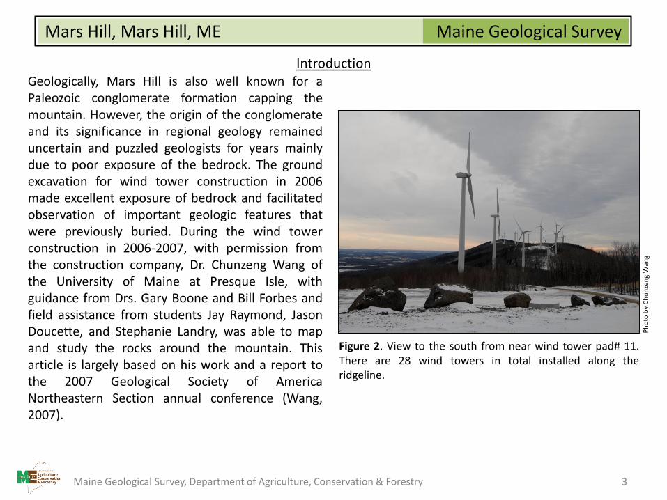
IntroductionGeologically, Mars Hill is also well known for aPaleozoic conglomerate formation capping themountain. However, the origin of the conglomerateand its significance in regional geology remaineduncertain and puzzled geologists for years mainlydue to poor exposure of the bedrock. The groundexcavation for wind tower construction in 2006made excellent exposure of bedrock and facilitatedobservation of important geologic features thatwere previously buried. During the wind towerconstruction in 2006-2007, with permission fromthe construction company, Dr. Chunzeng Wang ofthe University of Maine at Presque Isle, withguidance from Drs. Gary Boone and Bill Forbes andfield assistance from students Jay Raymond, JasonDoucette, and Stephanie Landry, was able to mapand study the rocks around the mountain. Thisarticle is largely based on his work and a report tothe 2007 Geological Society of AmericaNortheastern Section annual conference (Wang,2007).
Figure 2. View to the south from near wind tower pad# 11.There are 28 wind towers in total installed along theridgeline.
Ph
oto
by
Ch
un
zen
gW
ang
Maine Geological Survey, Department of Agriculture, Conservation & Forestry 3
Maine Geological SurveyMars Hill, Mars Hill, ME
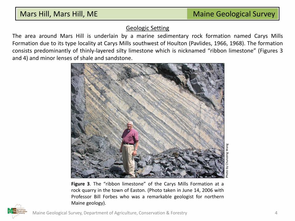
Geologic SettingThe area around Mars Hill is underlain by a marine sedimentary rock formation named Carys MillsFormation due to its type locality at Carys Mills southwest of Houlton (Pavlides, 1966, 1968). The formationconsists predominantly of thinly-layered silty limestone which is nicknamed “ribbon limestone” (Figures 3and 4) and minor lenses of shale and sandstone.
Figure 3. The “ribbon limestone” of the Carys Mills Formation at arock quarry in the town of Easton. (Photo taken in June 14, 2006 withProfessor Bill Forbes who was a remarkable geologist for northernMaine geology).
Ph
oto
by
Ch
un
zen
gW
ang
Maine Geological Survey, Department of Agriculture, Conservation & Forestry 4
Maine Geological SurveyMars Hill, Mars Hill, ME
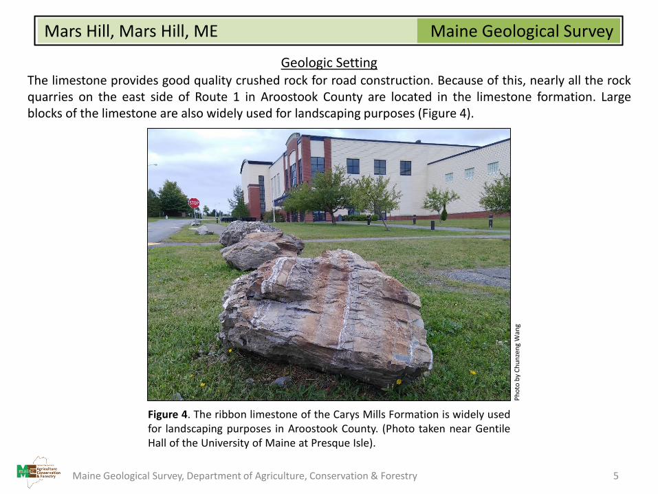
Geologic SettingThe limestone provides good quality crushed rock for road construction. Because of this, nearly all the rockquarries on the east side of Route 1 in Aroostook County are located in the limestone formation. Largeblocks of the limestone are also widely used for landscaping purposes (Figure 4).
Figure 4. The ribbon limestone of the Carys Mills Formation is widely usedfor landscaping purposes in Aroostook County. (Photo taken near GentileHall of the University of Maine at Presque Isle).
Ph
oto
by
Ch
un
zen
gW
ang
Maine Geological Survey, Department of Agriculture, Conservation & Forestry 5
Maine Geological SurveyMars Hill, Mars Hill, ME
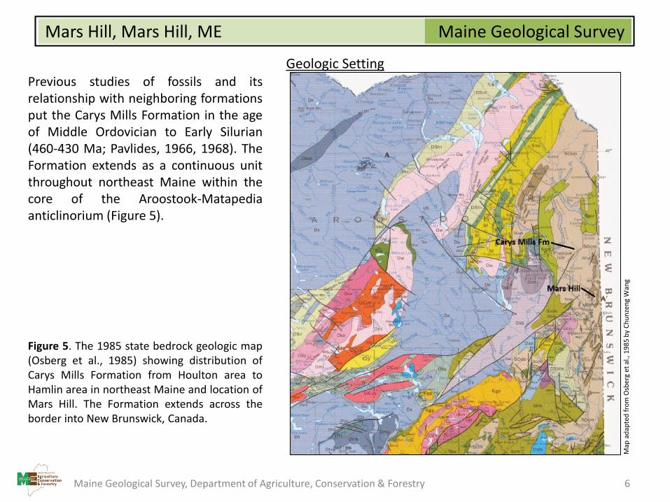
Geologic SettingPrevious studies of fossils and itsrelationship with neighboring formationsput the Carys Mills Formation in the ageof Middle Ordovician to Early Silurian(460-430 Ma; Pavlides, 1966, 1968). TheFormation extends as a continuous unitthroughout northeast Maine within thecore of the Aroostook-Matapediaanticlinorium (Figure 5).
Figure 5. The 1985 state bedrock geologic map(Osberg et al., 1985) showing distribution ofCarys Mills Formation from Houlton area toHamlin area in northeast Maine and location ofMars Hill. The Formation extends across theborder into New Brunswick, Canada.
Map
ad
apte
d f
rom
Osb
erg
et a
l., 1
98
5 b
y C
hu
nze
ng
Wan
g
Maine Geological Survey, Department of Agriculture, Conservation & Forestry 6
Maine Geological SurveyMars Hill, Mars Hill, ME
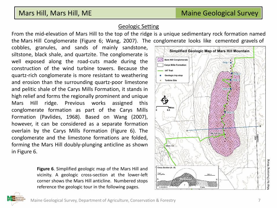
Geologic SettingFrom the mid-elevation of Mars Hill to the top of the ridge is a unique sedimentary rock formation namedthe Mars Hill Conglomerate (Figure 6; Wang, 2007). The conglomerate looks like cemented gravels ofcobbles, granules, and sands of mainly sandstone,siltstone, black shale, and quartzite. The conglomerate iswell exposed along the road-cuts made during theconstruction of the wind turbine towers. Because thequartz-rich conglomerate is more resistant to weatheringand erosion than the surrounding quartz-poor limestoneand pelitic shale of the Carys Mills Formation, it stands inhigh relief and forms the regionally prominent and uniqueMars Hill ridge. Previous works assigned thisconglomerate formation as part of the Carys MillsFormation (Pavlides, 1968). Based on Wang (2007),however, it can be considered as a separate formationoverlain by the Carys Mills Formation (Figure 6). Theconglomerate and the limestone formations are folded,forming the Mars Hill doubly-plunging anticline as shownin Figure 6.
Figure 6. Simplified geologic map of the Mars Hill andvicinity. A geologic cross-section at the lower-leftcorner shows the Mars Hill anticline. Numbered stopsreference the geologic tour in the following pages. M
ap b
y C
hu
nze
ng
Wan
g
Maine Geological Survey, Department of Agriculture, Conservation & Forestry 7
Maine Geological SurveyMars Hill, Mars Hill, ME
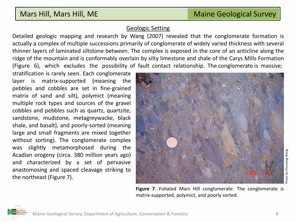
Geologic SettingDetailed geologic mapping and research by Wang (2007) revealed that the conglomerate formation isactually a complex of multiple successions primarily of conglomerate of widely varied thickness with severalthinner layers of laminated siltstone between. The complex is exposed in the core of an anticline along theridge of the mountain and is conformably overlain by silty limestone and shale of the Carys Mills Formation(Figure 6), which excludes the possibility of fault contact relationship. The conglomerate is massive;
stratification is rarely seen. Each conglomeratelayer is matrix-supported (meaning thepebbles and cobbles are set in fine-grainedmatrix of sand and silt), polymict (meaningmultiple rock types and sources of the gravelcobbles and pebbles such as quartz, quartzite,sandstone, mudstone, metagreywacke, blackshale, and basalt), and poorly-sorted (meaninglarge and small fragments are mixed togetherwithout sorting). The conglomerate complexwas slightly metamorphosed during theAcadian orogeny (circa. 380 million years ago)and characterized by a set of pervasiveanastomosing and spaced cleavage striking tothe northeast (Figure 7).
Figure 7. Foliated Mars Hill conglomerate. The conglomerate ismatrix-supported, polymict, and poorly sorted.
Ph
oto
by
Ch
un
zen
gW
ang
Maine Geological Survey, Department of Agriculture, Conservation & Forestry 8
Maine Geological SurveyMars Hill, Mars Hill, ME
Geologic Setting
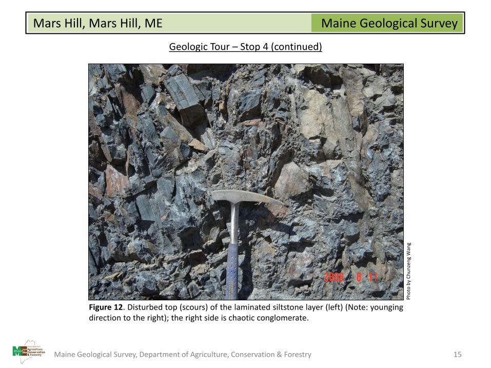
Erosional sole markings such as scours and siltstone-chip breccia are observed overlying the top of eachlaminated siltstone (see Figures 12 and 13), indicating an origin for the conglomerate layers by violent, high-density debris flows in a deep submarine canyon. The alternating successions of massive conglomerate andlaminated siltstone demonstrates not only a dramatic change between violent, high-energy environment(for the conglomerate) and quiet, low-energy environment (for the laminated siltstone), but also multiplepulses of submarine mass movement during probably the Late Ordovician time (about 443 million yearsago).
Maine Geological Survey, Department of Agriculture, Conservation & Forestry 9
Maine Geological SurveyMars Hill, Mars Hill, ME
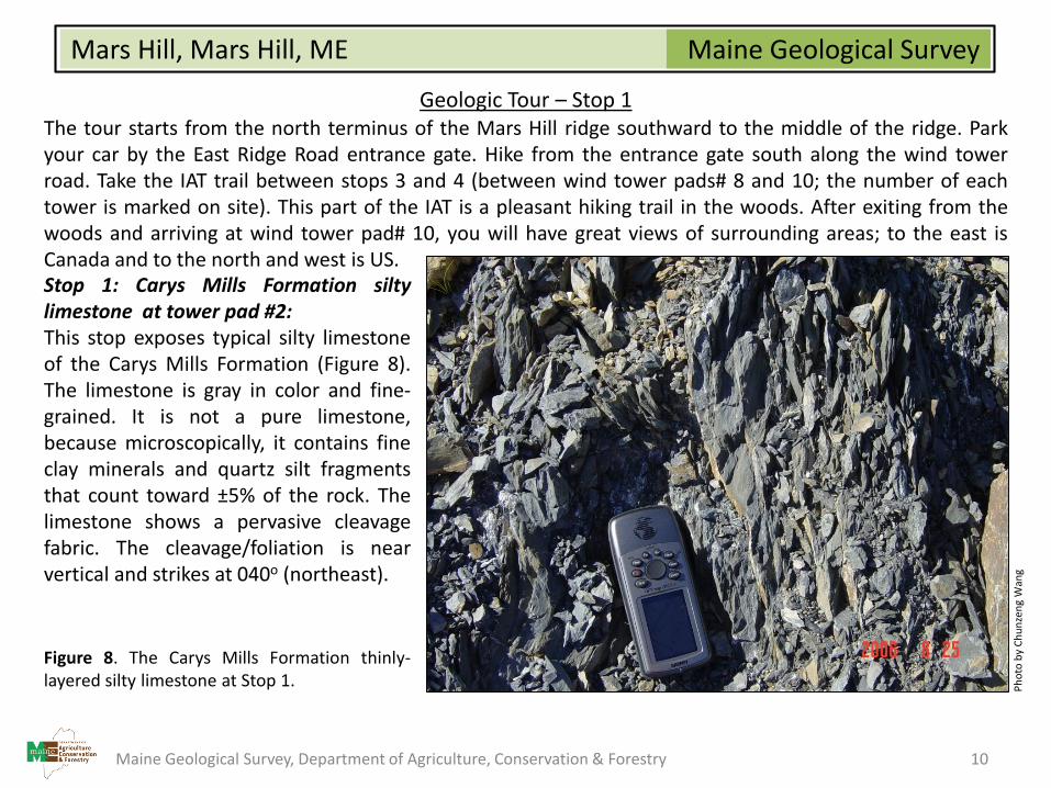
Geologic Tour – Stop 1The tour starts from the north terminus of the Mars Hill ridge southward to the middle of the ridge. Parkyour car by the East Ridge Road entrance gate. Hike from the entrance gate south along the wind towerroad. Take the IAT trail between stops 3 and 4 (between wind tower pads# 8 and 10; the number of eachtower is marked on site). This part of the IAT is a pleasant hiking trail in the woods. After exiting from thewoods and arriving at wind tower pad# 10, you will have great views of surrounding areas; to the east isCanada and to the north and west is US.Stop 1: Carys Mills Formation siltylimestone at tower pad #2:This stop exposes typical silty limestoneof the Carys Mills Formation (Figure 8).The limestone is gray in color and fine-grained. It is not a pure limestone,because microscopically, it contains fineclay minerals and quartz silt fragmentsthat count toward ±5% of the rock. Thelimestone shows a pervasive cleavagefabric. The cleavage/foliation is nearvertical and strikes at 040o (northeast).
Figure 8. The Carys Mills Formation thinly-layered silty limestone at Stop 1. P
ho
to b
y C
hu
nze
ng
Wan
g
Maine Geological Survey, Department of Agriculture, Conservation & Forestry 10
Maine Geological SurveyMars Hill, Mars Hill, ME
Geologic Tour – Stop 2
Stop 2: Contact between Mars Hill Conglomerate and fine clastic sedimentary rocks (sandstone, siltstoneand shale) at tower pad #6:This site exposes a contact between fine-grained sedimentary rocks of sandstone, siltstone, and shale thatoccur as thin layers and breccia-type conglomerate that changes to typical Mars Hill conglomerate to thesouth. The conglomerate is chaotic and poorly-sorted. Clasts (granules, pebbles, cobbles, and/or boulders)are either angular or rounded in shape. The contact between both coarse- and fine-grained is gradational,suggesting it is not a fault contact but conformable depositional contact. The bedding plane strikes at 260-290o and dips at 30o toward northwest.
Maine Geological Survey, Department of Agriculture, Conservation & Forestry 11
Maine Geological SurveyMars Hill, Mars Hill, ME
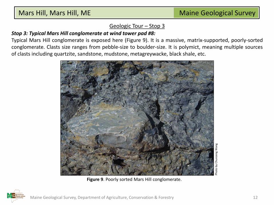
Geologic Tour – Stop 3Stop 3: Typical Mars Hill conglomerate at wind tower pad #8:Typical Mars Hill conglomerate is exposed here (Figure 9). It is a massive, matrix-supported, poorly-sortedconglomerate. Clasts size ranges from pebble-size to boulder-size. It is polymict, meaning multiple sourcesof clasts including quartzite, sandstone, mudstone, metagreywacke, black shale, etc.
Figure 9. Poorly sorted Mars Hill conglomerate.
Ph
oto
by
Ch
un
zen
gW
ang
Maine Geological Survey, Department of Agriculture, Conservation & Forestry 12
Maine Geological SurveyMars Hill, Mars Hill, ME
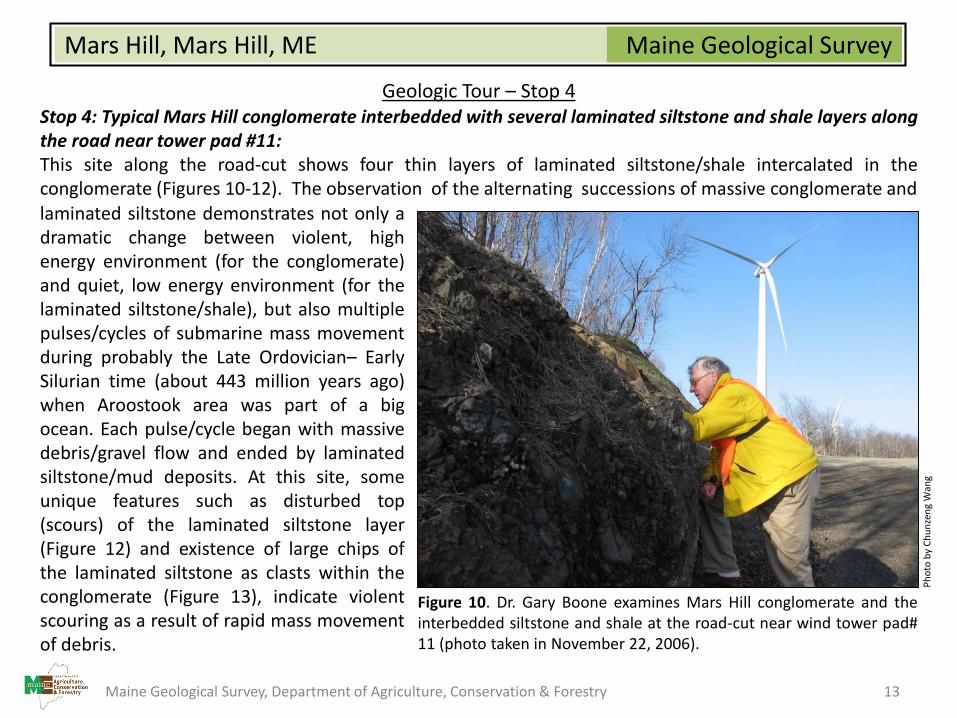
Geologic Tour – Stop 4Stop 4: Typical Mars Hill conglomerate interbedded with several laminated siltstone and shale layers alongthe road near tower pad #11:This site along the road-cut shows four thin layers of laminated siltstone/shale intercalated in theconglomerate (Figures 10-12). The observation of the alternating successions of massive conglomerate andlaminated siltstone demonstrates not only adramatic change between violent, highenergy environment (for the conglomerate)and quiet, low energy environment (for thelaminated siltstone/shale), but also multiplepulses/cycles of submarine mass movementduring probably the Late Ordovician– EarlySilurian time (about 443 million years ago)when Aroostook area was part of a bigocean. Each pulse/cycle began with massivedebris/gravel flow and ended by laminatedsiltstone/mud deposits. At this site, someunique features such as disturbed top(scours) of the laminated siltstone layer(Figure 12) and existence of large chips ofthe laminated siltstone as clasts within theconglomerate (Figure 13), indicate violentscouring as a result of rapid mass movementof debris.
Figure 10. Dr. Gary Boone examines Mars Hill conglomerate and theinterbedded siltstone and shale at the road-cut near wind tower pad#11 (photo taken in November 22, 2006).
Ph
oto
by
Ch
un
zen
gW
ang
Maine Geological Survey, Department of Agriculture, Conservation & Forestry 13

Maine Geological SurveyMars Hill, Mars Hill, ME
Geologic Tour – Stop 4 (continued)
Figure 11. The Mars Hill conglomerate (left) and the interbedded siltstone (right) atwind tower pad# 10.
Ph
oto
by
Ch
un
zen
gW
ang
Maine Geological Survey, Department of Agriculture, Conservation & Forestry 14
Maine Geological SurveyMars Hill, Mars Hill, ME
Geologic Tour – Stop 4 (continued)
Figure 12. Disturbed top (scours) of the laminated siltstone layer (left) (Note: youngingdirection to the right); the right side is chaotic conglomerate.
Ph
oto
by
Ch
un
zen
gW
ang
Maine Geological Survey, Department of Agriculture, Conservation & Forestry 15
Maine Geological SurveyMars Hill, Mars Hill, ME
Geologic Tour – Stop 4 (continued)
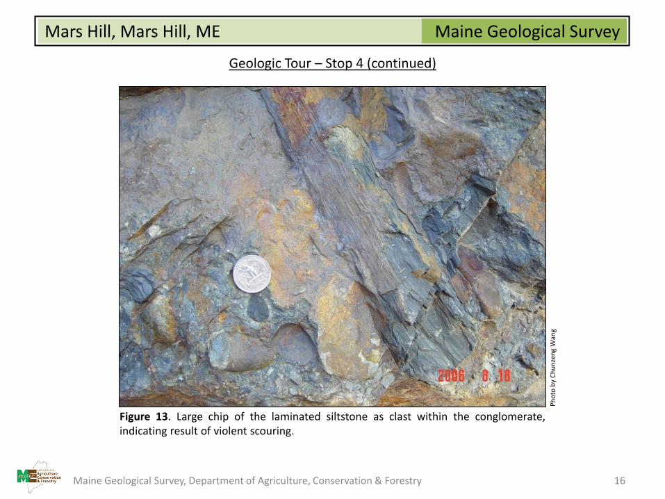
Figure 13. Large chip of the laminated siltstone as clast within the conglomerate,indicating result of violent scouring.
Ph
oto
by
Ch
un
zen
gW
ang
Maine Geological Survey, Department of Agriculture, Conservation & Forestry 16

Maine Geological SurveyMars Hill, Mars Hill, ME
Geologic Tour – Stop 5Stop 5: Typical Mars Hill conglomerate at the road-cut near wind tower pad #19:The road-cut shows all the features and fabrics of the typical Mars Hill conglomerate (Figure 14). Theconglomerate is massive and poorly-sorted. It is also polymict with multiple types of rocks as its clasts.These features again demonstrate that the Mars Hill conglomerate complex originated as submarinemassive debris flows. It is likely that this happened in a shelf-slope environment and most likely within adeep submarine canyon.
Figure 14. Typical pebble conglomerate of the Mars Hill Conglomerate.
Ph
oto
by
Ch
un
zen
gW
ang
Maine Geological Survey, Department of Agriculture, Conservation & Forestry 17
Maine Geological SurveyMars Hill, Mars Hill, ME
References and Additional Information
Osberg, Philip H., Hussey, Arthur M., II, and Boone, Gary M. (editors), 1985, Bedrock geologic map of Maine: MaineGeological Survey, 1 plate, correlation chart, tectonic inset map, metamorphic inset map, color geologic map,cross sections, scale 1:500,000.
Pavlides, Louis, 1968, Stratigraphic and facies relationships of the Carys Mills Formation of Ordovician and Silurian age,northeast Maine: U. S. Geological Survey, Bulletin 1264, 44 p. report, color map, scale 1:250,000.
Pavlides, L., 1966. Meduxnelmag Group and Spragueville Formation of Aroostook County, northeast Maine, in Cohee, G.V., and West, W. S., Changes in stratigraphic nomenclature by the U.S. Geological Survey, 1965: U.S. GeologicalSurvey Bulletin 1244-A, p. A52-A57
Wang, C., 2007. The Mars Hill Conglomerate, Northeastern Maine: a Pre-Acadian Submarine Debris-Flow Complex?Geological Society of America Abstracts with Programs, Vol. 39, No. 1, p. 48.
Maine Geological Survey, Department of Agriculture, Conservation & Forestry 18