Design Of Rockery Walls On Marginally Stable Talus Slopes ... · Design Of Rockery Walls On...
13
1 Design Of Rockery Walls On Marginally Stable Talus Slopes Taylor River Road, Gunnison County, Colorado William C.B. Gates, Kleinfelder, 2405 140 th Ave NE, Suite A101, Bellevue, WA 98005, 425-562-4200, [email protected] Brendan Fisher, Kleinfelder, 2405 140 th Ave NE, Suite A101, Bellevue, WA 98005, 425-562-4200, [email protected] Chad Lukkarila, Kleinfelder, 2405 140 th Ave NE, Suite A101, Bellevue, WA 98005, 425-562-4200, [email protected] Kami Deputy, Kleinfelder, 2405 140 th Ave NE, Suite A101, Bellevue, WA 98005, 425-562-4200, [email protected] Samantha Sherwood, Kleinfelder, 611 Corporate Circle, Suite C, Golden, CO, 80401, 303-237-6601 [email protected] Daniel E. Alzamora, FHWA, CFLD, 12300 West Dakota Ave., Suite 210, Lakewood, CO 80228, 720-963-3518 [email protected] ABSTRACT Rockery walls are gravity walls that consist of uncemented, interlocking rows of large rocks that are not tied together and have a low tolerance for movement. The rocks are naturally shaped quarry stone or boulders. Typically, they are only constructed on slopes that are relatively stable. They are not structural walls and are usually employed for erosion control. The Federal Highway Administration Central Federal Lands is currently considering realigning 22km (14 miles) of road along the Taylor River in the Gunnison National Forrest in Colorado. Major proposed improvements include straightening and realigning curves, design of 35 substantial rock and soil cuts and 23 rockery walls to stabilize the toe of talus slopes. Talus aprons paralleling the proposed alignment are composed of both granitic and metamorphic rock colluvium ranging from small cobbles to very large boulders 5m (16 feet) in diameter. Existing talus slopes are inclined at the angle of repose. Therefore these deposits are at equilibrium, exhibit a factor of safety of unity and are marginally stable. Excavation of the toe may cause the deposits to slough off towards the roadway. During the project, the authors were faced with the following design challenges: • Designing rockery walls as structural walls composed of talus rock with the dual purpose of providing erosion control and to retain marginally stable slopes. • Estimating critical stable height/base ratios for the rockery walls considering overturning, sliding, and bearing capacity of the walls.
Transcript of Design Of Rockery Walls On Marginally Stable Talus Slopes ... · Design Of Rockery Walls On...

1
Design Of Rockery Walls On Marginally Stable Talus Slopes Taylor River Road, Gunnison County, Colorado
William C.B. Gates, Kleinfelder, 2405 140th Ave NE, Suite A101, Bellevue, WA 98005, 425-562-4200, [email protected] Brendan Fisher, Kleinfelder, 2405 140th Ave NE, Suite A101, Bellevue, WA 98005, 425-562-4200, [email protected] Chad Lukkarila, Kleinfelder, 2405 140th Ave NE, Suite A101, Bellevue, WA 98005, 425-562-4200, [email protected] Kami Deputy, Kleinfelder, 2405 140th Ave NE, Suite A101, Bellevue, WA 98005, 425-562-4200, [email protected] Samantha Sherwood, Kleinfelder, 611 Corporate Circle, Suite C, Golden, CO, 80401, 303-237-6601 [email protected] Daniel E. Alzamora, FHWA, CFLD, 12300 West Dakota Ave., Suite 210, Lakewood, CO 80228, 720-963-3518 [email protected]
ABSTRACT
Rockery walls are gravity walls that consist of uncemented, interlocking rows of large rocks that are not tied together and have a low tolerance for movement. The rocks are naturally shaped quarry stone or boulders. Typically, they are only constructed on slopes that are relatively stable. They are not structural walls and are usually employed for erosion control.
The Federal Highway Administration Central Federal Lands is currently considering realigning 22km (14 miles) of road along the Taylor River in the Gunnison National Forrest in Colorado. Major proposed improvements include straightening and realigning curves, design of 35 substantial rock and soil cuts and 23 rockery walls to stabilize the toe of talus slopes.
Talus aprons paralleling the proposed alignment are composed of both granitic and metamorphic rock colluvium ranging from small cobbles to very large boulders 5m (16 feet) in diameter. Existing talus slopes are inclined at the angle of repose. Therefore these deposits are at equilibrium, exhibit a factor of safety of unity and are marginally stable. Excavation of the toe may cause the deposits to slough off towards the roadway.
During the project, the authors were faced with the following design challenges:
• Designing rockery walls as structural walls composed of talus rock with the dual purpose of providing erosion control and to retain marginally stable slopes.
• Estimating critical stable height/base ratios for the rockery walls considering overturning, sliding, and bearing capacity of the walls.

2
INTRODUCTION
Rockery walls are gravity walls that consist of uncemented, interlocking rows of large rocks that are not tied together and have a low tolerance for movement. The rocks are natural shaped quarry stone or boulders. Typically, they are only constructed on slopes that are relatively stable. They are not structural walls but can be employed for erosion control. Many rockery walls are only single tier, however, if designed properly they may be multitiered as displayed on Figure 1.
Talus slopes are colluvial deposits that have been deposited by some means of mass wasting. The face of the talus deposits rest at the angle of repose, which by definition is at a factor of safety of unity (1) or just at equilibrium. Typically, the angle of repose for talus is in the range of 37 to about 42 degrees depending on the textural gradation of the deposits (Figure 2). Coarse deposits with large blocks may stand steeper. Oversteepening the toe of the talus deposit may affect the marginal stability and cause the deposit to reestablish equilibrium by sliding. In the past, rockery walls have been employed by the Federal Highway Administration (FHWA) to stabilize the toes of talus slopes along the road in the Taylor River Canyon (Figure 3).
This paper presents the results of our geotechnical investigation for the proposed rockery walls that will be required as part of the rehabilitation and realigning of 22 kilometers (14 miles) of road along the Taylor River in the Gunnison National Forest in Central Colorado (Kleinfelder, 2006). Proposed improvements include straightening and realigning curves, construction of substantial cuts and fills, stabilization of talus slope toes, excavation of at least 35 new rock cuts and soil cuts, and construction of at least 23 rockery walls. The proposed rockery walls will average about 3.5 meters high and about 55m long, for a total length approaching 1.3km. Ten rockery walls have been designed for two tiers because the height of a single wall would exceed 3.5m (11.5 feet).
Figure 3: Rockery wall constructed at the toe of a talus slope along Taylor River Road, Colorado.
38°°°°
Figure 2: Talus slope with a 38°°°° angle of repose, Taylor River Road, Colorado.
Figure 1: Multitiered rockery wall near Reno, Nevada.

3
LOCATION AND ALIGNMENT DESCRIPTION
Taylor River Road starts at Almont, Colorado and follows the river through Taylor River Canyon to the Taylor River Dam and Reservoir (Figure 4). The 22 kilometers (14 miles) of roadway being investigated consists of a two-lane roadway with narrow shoulders. Rehabilitation plans include straightening the road that will require significant cut and fill sections. Cuts will traverse the toe of marginally stable talus slopes, glacial and terrace deposits. Two 3.3m (11 foot) lanes are planned with shoulders that will vary from about 0.3m to 1.5m (1 to 5 foot) in width.
The roadway is lined in various locations with existing soils in talus, glacial and terrace deposits and rock cut slopes. The soil slopes consist primarily of rock talus, sandy gravel (GP), clayey gravel and sand (GC/SC), poorly graded sand, (SP) silty sand (SM), and sandy clay with clayey sand (SC/CL). The existing soil slopes range in height from less than one meter to approximately six meters (3 to 20 feet) and have slope inclinations ranging from 25- to 50-degrees. The rock slopes vary from fresh and very strong granites, gneisses, and quartzites to highly weathered and very weak metamorphic rock including schist. The existing rock slopes range in height from approximately 2 to 20 meters (6 to 65 feet) and have slope inclinations ranging from 45- to 90-degrees.
REGIONAL GEOLOGY AND SEISMIC CONDITIONS
Taylor River is located on the western flank of the Sawatch Mountains in the Rocky Mountains of Colorado. The river has cut a deep gorge through Precambrian metamorphic rock on the northeast and southwest end of the alignment and granitic rock near the middle of the alignment. During the Laramide Orogeny, the area was subjected to uplift, folding, and thrust faulting. Renewed movement, probably during the Miocene period, dissected the area with a series of high angle normal faults. The last major process to affect the area was glaciation, which modified the preexisting erosional valleys by additionally carving or infilling with debris. The majority of surface exposures in which cuts will be involved along the alignment consist of igneous granitic and metamorphic rocks (consisting of quartzite, gneiss and schist) or talus and soil cover with frequent granitic boulders up to several meters in diameter. According to the United States Geological Survey website http://eqint.cr.usgs.gov/eq-men/cgi-bin/zipcode-06.cgi the estimated probabilistic peak ground acceleration (PGA) with 10% probability of exceedance in 50 years is equal to 0.077g.
Figure 4: Project Area, Taylor River Road, Colorado (Google Earth, 2006)

4
FIELD AND SUBSURFACE INVESTIGATION
During the summer and fall of October 2005, the authors visited Taylor River Road to observe the geology and geometrics of the road, conduct field mapping at rock outcrops and investigate the talus and soil slopes. We completed thirty (30) test pits at the locations where FHWA had proposed either soil excavations or rockery walls. The test pits were logged in the field and the relative density or consistency of the soil was recorded. Soil samples from the talus matrix were collected from each test pit for index and direct shear testing.
ROCKERY WALL DESIGN METHODOLOGY
It is important to note that similar walls were constructed north of the project area by FHWA. The geometry of the constructed walls was considered during design of the walls described herein.
The chart on Figure 5 was used to facilitate design of the rockery walls along Taylor River Road. The rockery walls planned along Taylor River were designed according to methods developed by Hendron (1960), Gifford and Kirkland (1978), Associated Rockery Contractors (1991), Gray and Sotir (1996), and FHWA (2005). The results of each methodology were considered while estimating the width of the base of the rockery walls planned for the Taylor River Road. The authors established the minimum width of the walls to be equal to one half of the wall height and used the design calculations by Gray and Sotir (1996) to check this assumption. The maximum wall height was checked against the chart developed by Hendron (1960), which considers moment equilibrium only. Figure 5 is a similar chart developed for the rockery walls on Taylor River road with modifications for the site-specific soil and rock engineering properties.
The active earth pressure coefficient is not factored in this chart (Figure 5), which means that there is no safety factor on the wall design. The chart shows the critical H/B ratio given a horizontal backfill with soil that has a friction angle of 35 or 40 degrees. The backfill has a unit weight of about 2,080 kg/m3 (130 pcf) and the wall has a unit weight of about 2,400 kg/m3 (150 pcf). To read the chart, first estimate the required height of the wall. Then, given a specific wall angle, the engineer can back out the width at the base of the wall. Because the chart is based solely on moment equilibrium, sliding, and bearing capacity is not considered and should be evaluated separately.
For each of the rockery wall geometries considered for the Taylor River Road project, the back slope behind the wall was assumed to slightly less than angle of repose of talus slopes observed along the Taylor River Roadway. Although the back slopes will be at the angle of repose, the Rankine and Coulomb equations for active earth pressures become meaningless when the friction angle of the soil is equal to the back slope inclination. The angle of repose of the talus was conservatively chosen as the backfill friction angle because the backfill will consist of compacted and crushed talus. In addition, during our calculations and assessment, we assumed that the walls would be constructed vertically, which is a conservative assumption.

5
Read the chart as follows: 1. PCW is a Poorly-constructed wall 2. WCW is a Well-constructed wall 3. θ is the inclination of the wall face measured from the horizontal. 4. Ka is active earth pressure coefficient. The drained friction angle of the backfill is assumed to be 35 or 40 degrees. 5. H/B is the height to base width ratio 6. Wall unit weight is 150 pcf 7. Backfill is 130 pcf 8. Backfill is horizontal
Figure 5: Unfactored critical H/B ratios used for rockery wall designs on Taylor River Road (Modified from Hendron, 1960).

6
The friction factor for sliding between the rock of the wall and the foundation soil (�) was found by taking the tangent of the friction angle, multiplying by 0.75 and dividing by the desired factor of safety (FS) as suggested by FHWA (2005). This relationship is outlined in the equation below.
FS75.0*tanφµ =
Passive resistance in front of the walls was neglected, because it is hard to verify uniform compaction at the toe of a rockery wall without full-time construction observation and testing. Further, it is anticipated that the base of the walls will be constructed above the frost line and therefore, soil in front of the wall will deteriorate over time.
The overturning and sliding stability of the rockeries was estimated under seismic loading. As discussed above, the peak ground acceleration (PGA) at Gunnison, CO was found to be 0.077g for a 10% probability of exceedance in 50 years. Kh (horizontal component of acceleration) was assumed equal to one half the peak ground acceleration and Kv (vertical component of acceleration) was assumed to be zero for the seismic case. Since Kh was calculated from the PGA, a tolerable displacement was not estimated or used in the calculations. The factor of safety against seismic failure was calculated using a modified procedure from Pile Buck, Inc (1992). Pseudo-static stability did not govern the design of the rockery walls.
Global slope stability analyses were performed for both the single tier and multitiered rockery walls. Studies showed that the global minimum factors of safety were satisfied for both the static and psuedo-static cases when sliding is assumed to occur beneath the walls. The walls could not be designed to mitigate shallow sloughing behind the walls because the talus will remain at the angle of repose. Re-grading the talus backslopes to remove loose material can reduce the potential for shallow sloughing.
GENERAL ROCKERY WALL DESIGN GUIDLINES
Over the past years there has been a variety of design guideline suggestions on rockery walls provided by organizations and agencies. For instance, the Associated Rockery Contractors (ARC) published Rock Wall Construction Guidelines circa 1992 attendant to construction of rock walls. In addition, FHWA Central Federal Lands (CFL) has been working on a draft document for Rockery Design and Construction Guidelines (FHWA-CFL, 2005). The following is a summary of the guidelines as they relate to the Taylor River Road project, however, they are also appropriate for other similar construction projects.
The rockery wall will act as a protective system, which retards the weathering and erosion process acting on the cuts in the talus and soils. The degree of retention achieved is a function of the mass of the rock selected for the rockery wall and the height of the rockery wall. Based on our research, the maximum height of a given rockery wall should be limited to 3.5m (11.5 feet) unless the retained soil behind the wall is reinforced as a Mechanically Stabilized Earth wall reinforced with geogrids or geotextiles. (Note: Some local jurisdictions have proposed 2.5m (8 feet) as the limit for an unreinforced rockery wall (Draft Southern Nevada Local Standard, 2005)). With our research in mind, we established that the minimum base width of the walls should be equal to one half the wall height. Where higher walls are required, we recommended

7
FHWA consider using a tiered wall system. The lower wall would be constructed at the roadway grade with subsequent walls placed a distance equal to height of the lower wall behind and above the lower wall to decrease the likelihood of applying additional surcharge on the lower wall. All walls must be keyed into a basal keyway trench. Figure 6 displays typical design and specification requirements for the rockery walls designed for Taylor River Road. The following are guidelines for rockery wall design and construction with narrative comment and examples.
GEOTECHNICAL ENGINEER
Typically, rockery walls that equal or exceed a height of 1.2m (4 feet) should require engineering analysis and a geotechnical report. In these cases the project owner should retain a qualified geotechnical engineer to provide the engineering analysis and provide necessary supplemental rockery wall guidelines during construction. The engineer selected should demonstrate experience in being in responsible charge of a project, including experience with fill construction and stability and rockery wall construction.
Temporary slopes behind the walls that would be excavated by the contractor should always be the responsibility of the contractor. Moreover, the temporary slopes need also to be constructible. During the geotechnical investigation for Taylor River Road, temporary cuts within the talus were observed to stand for a short period. This was attributed to 3-D effects and arching behind the temporary cuts. Therefore, the back walls are constructible, but will require careful construction procedures.
MONITORING
Throughout the project, it is paramount that the geotechnical engineer periodically monitor all rockery walls constructed against cuts or fills exceeding 1.2m (4 feet) in height. It is important for the engineer to verify that the construction and materials meet the original geotechnical recommendations and specifications. The geotechnical engineer should also develop a monitoring plan for visiting the site. For instance, ARC (1991) recommends for a single tiered rockery wall that is less than 15m (50 feet) in length should require a minimum of at least one visit along with daily inspections by a project engineer. For multitiered rockery walls, the geotechnical engineer should visit the site at least once for each stage of the wall. The geotechnical engineer must maintain records of the nature and condition of the wall under observation.
In addition, the engineer should verify the soundness of the rocks selected for the rockery wall by striking the selected rocks with a geology hammer. A loud ring suggests strong competent rock. Conversely, a dull thud will suggest poor rock not fit for a rockery wall.

8
Figure 6: Rockery wall design schematic used for Taylor River Road.

9
Figure 7 displays an example of a rockery wall failing because weak unsound rock was selected for the wall rock.
FILL MATERIALS AND COMPACTION
On the Taylor River Road project, the rockery walls will be constructed in front of fill that has been placed in front of the temporary back slopes. Typically, the fill must be composed of 100 to 200 mm (4 to 8 in) rock. The fill must be placed and then tamped with a rod to compact the voids. The fill material must be clean and free of organics and debris. There should be no more than 5% fines passing the number 200 sieve. Fill should be placed in thin lifts not exceeding 250mm (10in) loose thickness.
GENERAL EXCAVATION
Prior to construction of the rockery wall the site for the footprint must be prepared. All loose rock, soil and debris must be excavated down to firm subgrade with a bearing strength of at least 97 KPa (2000 psf). Firm subgrade would be material that is relatively difficult to probe with a 13mm (0.5in) steel probe up to 150mm (6in). Soft material would be material that the engineer could probe beyond 150mm (6in). The base should be leveled. This may require excavation of large protruding rocks. Adding a layer of tamped coarse quarry spalls may firm up the soft subgrade. The backslope must be cut in sections of manageable lengths such that the rockery wall can be constructed in one workday. Temporary cut slopes (backwalls) should not be left open overnight because of the potential for collapse.
ROCKERY WALL KEYWAY
The first step in the rockery wall construction after general excavation is to construct a keyway trench. The keyway should be designed to contain the basal rock for the rockery wall. Figure 6 displays a typical design for the keyway beneath the rockery wall. Design the keyway as a shallow trench of not less than 300mm (12in) in depth. Extend the keyway the full length of the rockery wall. The width of the keyway should be as wide as the basal rock plus the drain rock layer. The keyway must be excavated in sections of manageable lengths such that the rockery wall can be constructed during one daylong shift. The keyway should be excavated into firm subgrade (see General Excavation). If soft material exists, strengthen and make the soil more firm placing base material meeting the gradation requirements outlined on Figure 6. Where the rockery wall supports a lateral load, a 150mm (6in) layer of base material should be installed. The base material will increase the friction between the subgrade and the base of the rockery wall.
Figure 7: Example of rockery wall failing because of placement and use of weak rock for wall rock.

10
ROCKERY WALL KEYWAY DRAINAGE
Along Taylor River Road, the rockery walls constructed in the talus deposits (free of a fine-grained matrix) typically do not require keyway drainage because typically the talus deposits are very course and free draining (Figure 8). Conversely the terrace and glacial deposits and talus with a soil matrix require drainage. Increased water pressure behind the rockery wall may lead to piping of the fines through the wall and ultimate failure of the wall. Figure 9 is an example of a rockery wall collapse related to poor drainage exacerbated by use and placement of poor unsuitable rock for the rock wall.
Upon completion of the keyway excavation, a 100mm (4in) minimum diameter perforated or slotted PVC drainpipe should be installed at the rear of the keyway behind the basal rock. Figure 6 is a typical schematic, which displays drainage design requirements.
ROCKERY WALL THICKNESS
Figure 6 displays general rock wall thickness guidelines. Typically the individual rock wall thickness will equal the width of the recommended rock plus the thickness of the drain rock behind. The rockery wall will act as a retaining structure therefore it is critical that the size and mass of the rock be adequate to resist the applied loads.
ROCK SELECTION
During construction, the constructor should insure that there is sufficient space to stockpile several selections of rock for the rockery. Along Taylor River, we expect that the constructor will be able to use good rock excavated from the talus, terrace and glacial deposits. Shapes of the rocks are important. The rocks must be cubical, tabular or rectangular so that they can rest upon each other in the wall. In addition, the rocks must
Figure 8: Rockery wall along Taylor River Road.
Figure 10: Rockery wall failing because of poor placement of rock and weak unsound rock.
Figure 9: Failure of rockery wall from poor drainage exacerbated by poor rock selection and placement, Reno, Nevada.

11
be hard and strong and ring when struck with a geology hammer. Furthermore, the rocks must be free of major weak zones such as cracks, seams and foliation. Spalling from repeated freezing and thawing activity might tend to break the rocks down. Therefore, if there is doubt, we recommend testing selected rock samples by ASTM C682 for Freeze-Thaw characteristics. Figure 10 is a photo of very weak rock that was selected for a rockery wall in the Reno, Nevada area. The rockery wall is failing not only because of the shape of the rocks but because the weathered weak rock is disintegrating and spalling around stronger core stones.
ROCK PLACEMENT
Figure 6 displays placement of the rocks in the rockery wall. In general, the first layer of rock should be placed on firm unyielding soil or on the previously installed layer of quarry spalls. The basal rock should fully contact the subsoil or prepared quarry spalls. This may require further shaping of the basal material or dropping or pounding the rock into the base so it conforms to the material. The bottom of the first course of rock should be a minimum of 300mm (12in) below the lowest adjacent site grade. As the wall is constructed, the rocks should be placed so that there are no continuous joint seams in the lateral as well as vertical. The rocks should be placed so that there are at least two rocks below it. In addition, the rock should be placed with the long axis into the slope. The rock should be placed so that it is bearing on the rock below. The rocks should be set such that there are no sloping faces out of the rock wall, which would create a plane of weakness for failure. Figures 3 and 8 display the FHWA walls constructed by FHWA. The rocks are tabular with good rock-to-rock contact and bear squarely upon each other forming a stable rockery wall. Conversely, Figures 7 and 10 display wall rock that is sub-round reducing the rock-to-rock bearing contact, which has jeopardized the stability of the rockery wall.
FACE INCLINATION
Figure 6 displays the inclination of the face of the rockery wall. Some jurisdictions may establish steeper battering of the wall face (Draft Southern Nevada Local Standard, 2005). Conservatively, the authors recommend as does FHWA (2005) battering the wall face to a ratio 4V:1H inclination measured at the exposed face of the rockery wall.
VOIDS
Because of the shape of the rocks used in the rockery wall, there will be voids created between individual rocks, especially the larger rocks. Voids should be minimized for long-term stability. Where voids exceed 150mm (6in) in diameter, the engineer should visually examine if the void continues through the width of the wall. If it is established that the void is surficial and there is rock-to-rock contact at depth, no further action is required. On the other hand if the void is through going, the void must be chinked with a smaller rock. Because of the potential for the chinking rock to fall out with subsequent loss of drain rock or soil behind the rockery wall, the void must be chinked from the inside of the wall if possible. In this way the lateral pressure will force the chink rock into the void. However, if it is impracticable to chink the voids from the inside face and the constructor elects to chink the void from the outside face, the chinking rocks should be hammered in to insure a tight fit. Chinking rocks must be of the same quality as that for the large rocks. The photo in Figure 10 displays chinking rock that failed and fell out of the
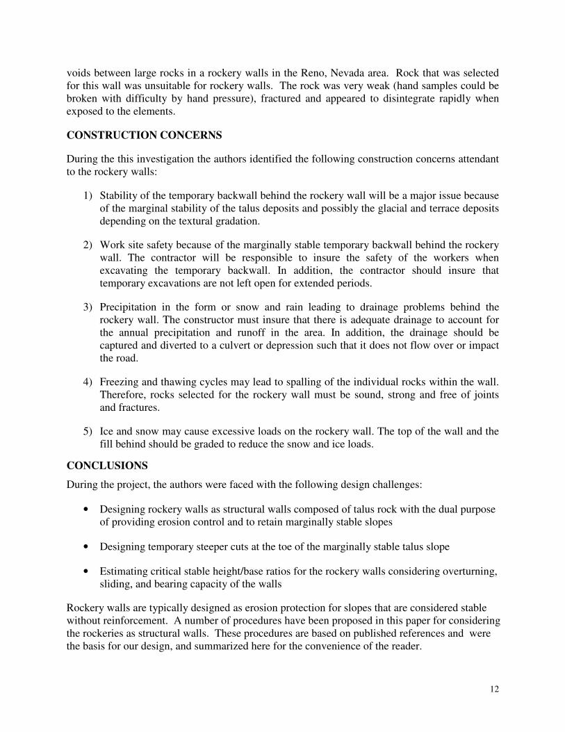
12
voids between large rocks in a rockery walls in the Reno, Nevada area. Rock that was selected for this wall was unsuitable for rockery walls. The rock was very weak (hand samples could be broken with difficulty by hand pressure), fractured and appeared to disintegrate rapidly when exposed to the elements.
CONSTRUCTION CONCERNS
During the this investigation the authors identified the following construction concerns attendant to the rockery walls:
1) Stability of the temporary backwall behind the rockery wall will be a major issue because of the marginal stability of the talus deposits and possibly the glacial and terrace deposits depending on the textural gradation.
2) Work site safety because of the marginally stable temporary backwall behind the rockery wall. The contractor will be responsible to insure the safety of the workers when excavating the temporary backwall. In addition, the contractor should insure that temporary excavations are not left open for extended periods.
3) Precipitation in the form or snow and rain leading to drainage problems behind the rockery wall. The constructor must insure that there is adequate drainage to account for the annual precipitation and runoff in the area. In addition, the drainage should be captured and diverted to a culvert or depression such that it does not flow over or impact the road.
4) Freezing and thawing cycles may lead to spalling of the individual rocks within the wall. Therefore, rocks selected for the rockery wall must be sound, strong and free of joints and fractures.
5) Ice and snow may cause excessive loads on the rockery wall. The top of the wall and the fill behind should be graded to reduce the snow and ice loads.
CONCLUSIONS
During the project, the authors were faced with the following design challenges:
• Designing rockery walls as structural walls composed of talus rock with the dual purpose of providing erosion control and to retain marginally stable slopes
• Designing temporary steeper cuts at the toe of the marginally stable talus slope
• Estimating critical stable height/base ratios for the rockery walls considering overturning, sliding, and bearing capacity of the walls
Rockery walls are typically designed as erosion protection for slopes that are considered stable without reinforcement. A number of procedures have been proposed in this paper for considering the rockeries as structural walls. These procedures are based on published references and were the basis for our design, and summarized here for the convenience of the reader.

13
There is precedent for designing and constructing rockeries as structural reinforcing elements. FHWA’s constructed a series of walls to retain talus slopes north of the current Taylor River Road project area without incident. The talus would not be considered stable at such steep inclinations without reinforcement.
Construction quality control is paramount when specifying rockery walls as reinforcing walls. Hendron (1960) noted this when he produced the design charts modified as part of this paper. We have described a number of practical examples where the integrity of rockeries was compromised because of poor construction procedures. Important aspects of construction that require monitoring include the excavation of a keyway, gradation and compaction of the wall backfill, selection of good strong rock for the wall, “chinking” rock selected for the voids, and proper drainage.
REFERENCES
Associated Rock Wall Contractors (ARC), Rock Wall Construction Guidelines, Woodinville, Washington, 1992.
Federal Highway Administration, Rockery Design and Construction Guidelines, Interim Report No. 2 – Rockery Design, Publication No. FHWA-CFL/TD-05-00x, 2005, 35 p.
Gifford, A.B. and Kirkland, T.E., Uses and Abuses of Rockeries. Proceedings of the Annual Engineering Geology and Soils Engineering Symposium No 16, 1978, pp. 55-68
Gray, D. H. and R. B./ Sotir, Biotechnical and Soil Bioengineering Slope Stabilization. John Wiley & Sons, New York, 1996.
Hendron, A. J., Jr., Stability Analysis of a Rockery, In-house report, Shannon & Wilson, Inc., 1960.
Kleinfelder, Inc, Geotechnical Investigation Report Taylor River Road CO, PFH 59-1(4) Gunnison County, Colorado IDIQ Contract Number: DTFH68-02-D00002 Task Order No. DTFH68-00-D-00002/T-05-021, 2006.
Pile Buck, Inc., Earth Support Systems & Retaining Structures, Pile Buck, Inc® Jupiter, FL., 1992, pp 23-28.
Southern Nevada Local Standard, Rockery Wall Construction, Southern Nevada Local Standard: Developed by SNBO Structural Committee, Draft: February 14, 2005.