Deir Dibwan Town Profile
22
Deir Dibwan Town Profile Prepared by The Applied Research Institute – Jerusalem Funded by Spanish Cooperation 2012
Transcript of Deir Dibwan Town Profile

Deir Dibwan Town Profile
Prepared by
The Applied Research Institute – Jerusalem
Funded by
Spanish Cooperation
2012

Palestinian Localities Study Ramallah Governorate
1
Acknowledgments
ARIJ hereby expresses its deep gratitude to the Spanish Agency for International Cooperation for
Development (AECID) for their funding of this project.
ARIJ is grateful to the Palestinian officials in the ministries, municipalities, joint services councils,
village committees and councils, and the Palestinian Central Bureau of Statistics (PCBS) for their
assistance and cooperation with the project team members during the data collection process.
ARIJ also thanks all the staff who worked throughout the past couple of years towards the
accomplishment of this work.

Palestinian Localities Study Ramallah Governorate
2
Background
This report is part of a series of booklets, which contain compiled information about each city, town, and
village in the Ramallah Governorate. These booklets came as a result of a comprehensive study of all
localities in Ramallah Governorate, which aims at depicting the overall living conditions in the
governorate and presenting developmental plans to assist in developing the livelihood of the population
in the area. It was accomplished through the "Village Profiles and Needs Assessment;" the project
funded by the Spanish Agency for International Cooperation for Development (AECID).
The "Village Profiles and Needs Assessment" was designed to study, investigate, analyze and document
the socio-economic conditions and the needed programs and activities to mitigate the impact of the
current unsecure political, economic and social conditions in Ramallah Governorate.
The project's objectives are to survey, analyze, and document the available natural, human,
socioeconomic and environmental resources, and the existing limitations and needs assessment for the
development of the rural and marginalized areas in Ramallah Governorate. In addition, the project aims
at preparing strategic developmental programs and activities to mitigate the impact of the current
political, social, and economic instability with the focus on the agricultural sector.
All locality profiles in Arabic and English are available online at http://vprofile.arij.org.

Palestinian Localities Study Ramallah Governorate
3
Table of Content
Location and Physical Characteristics ________________________________________________4
History _________________________________________________________________________5
Religious and Archaeological Sites ___________________________________________________6
Population ______________________________________________________________________6
Education _______________________________________________________________________7
Health Status ____________________________________________________________________8
Economic Activities _______________________________________________________________8
Agricultural Sector _______________________________________________________________10
Institutions and Services __________________________________________________________12
Infrastructure and Natural Resources _______________________________________________12
Environmental Conditions _________________________________________________________14
Impact of the Israeli Occupation ____________________________________________________15
Development Plans and Projects ____________________________________________________18
Implemented Projects _____________________________________________________________18
Proposed Projects ________________________________________________________________19
Locality Development Priorities and Needs ___________________________________________20
References: _____________________________________________________________________21

Palestinian Localities Study Ramallah Governorate
4
Deir Dibwan Town Profile
Location and Physical Characteristics
Deir Dibwan is a Palestinian town in Ramallah Governorate, located 6.4km east of Ramallah City. Deir
Dibwan is bordered by „Ein ad Duyuk al Foqa territories to the east, Rammun and „Ein Yabrud
territories to the north, Beitin and Burqa villages to the west and Mikhmas village and „Anata territories
to the south (ARIJ GIS, 2012) (See Map 1)
Map 1: Deir Dibwan location and borders
Source: ARIJ GIS, 2012
Deir Dibwan is located at an altitude of 739m above sea level with a mean annual rainfall of 455mm.
The average annual temperature is 16o
C and the average annual humidity is approximately 60% (ARIJ
GIS, 2012).
Since 1956, Deir Dibwan has been governed by a Municipal Council which is currently administrated by
13 members appointed by the Palestinian National Authority with an additional 18 employees working

Palestinian Localities Study Ramallah Governorate
5
in the Council. The Council owns a permanent headquarters and two vehicles for the collection of solid
waste (Deir Dibwan Municipal Council, 2012).
It is the responsibility of the Municipal Council to provide a number of services to the residents of Deir
Dibwan, including (Deir Dibwan Municipal Council, 2012):
Solid waste collection, road construction and restoration, street cleaning and social development
services.
Organizing construction and licensing processes.
Providing headquarters for governmental services (post, security, etc.).
Implementing projects and case studies that contribute to the town‟s development.
Protecting historical and archeological sites in the town.
Protecting governmental properties.
History
Deir Dibwan town was originally a monastery („deir‟) for Roman monks, where a monk known as
Divan lived. Over time, the town‟s name shifted to Deir Dibwan. The town dates back to 1024
(according to the Hijri calendar), and its residents originate from East Jordan, Al Balqa‟ and Yemen
(Deir Dibwan Municipal Council, 2012).
Photo of Deir Dibwan

Palestinian Localities Study Ramallah Governorate
6
Religious and Archaeological Sites
There are two mosques in the town: Deir Dibwan Grand Mosque and Omar ben al Khattab Mosque. The
town has several sites of archaeological interest, including Khirbet Hayyan, Khirbet al Khudariya,
Khirbet at Tall, Khirbet Qasr at Tareez, Khirbet al Maqater, As Sabaq Monastery, Ad Darb Well, As
Sahel Well, and Al Jabiya Spring (Deir Dibwan Municipal Council, 2012) (See map 2).
Map 2: Main locations in Deir Dibwan Town
Source: ARIJ GIS, 2012
Population
According to the Palestinian Central Bureau of Statistics (PCBS), the total population of Deir Dibwan in
2007 was 4,937, of whom 2,268 were male and 2,669 female. There were 990 households living in
1,343 housing units.

Palestinian Localities Study Ramallah Governorate
7
Age Groups and Gender
The General Census of Population and Housing carried out by PCBS in 2007 showed that the
distribution of age groups in Deir Dibwan was as follows: 36% were less than 15 years of age, 55%
were between 15 and 64 years of age, and 8.8% were 65 years of age or older. Data additionally showed
that the sex ratio of males to females in the town is 85:100, meaning that males and females constitute
45.9% and 54.1 % of the population respectively.
Families
The inhabitants of Deir Dibwan town are from several families, mainly the Al „Awawdah, Al Manasrah
and As Sarmah families (Deir Dibwan Municipal Council, 2012).
Education
According to the results of the PCBS Population, Housing and Establishment Census-2007, the illiteracy
rate among population was about 11%, of whom 81.6% were females. Of the literate population, 14.5%
could only read and write, with no formal education, 28.3% had only elementary education, 24.7% had
preparatory education, 15.4% had secondary education, and 6% completed higher education. Table 1
shows the educational level in the town of Deir Dibwan by sex and educational attainment in 2007.
Table 1: Deir Dibwan population (10 years of age and above) by sex and educational attainment
S
E
x
Illiterate
Can
read &
write
Elementary Preparatory Secondary Associate
Diploma Bachelor
Higher
Diploma Master
PhD Unknown Total
M 77 276 550 396 282 35 84 3 11 1 - 1,715
F 343 278 529 548 307 32 51 - 10 2 3 2,103
T 420 554 1,079 944 589 67 135 3 21 3 3 3,818 Source: PCBS, 2009.
There are 5 public schools in the town run by the Palestinian Ministry of Higher Education (MoEHE),
but there are no kindergartens (See Table 2) (Directorate of Education in Ramallah, 2011).
Table 2: The Schools in Deir Dibwan by name, stage, sex, and supervising authority
School Name Supervising Authority Sex
Deir Dibwan Girls Secondary School Government Female
Deir Dibwan Co-educated Secondary School Government Mixed
Deir Dibwan Boys Industrial Secondary School Government Male
Deir Dibwan Boys Elementary School Government Male
Deir Dibwan Girls Elementary School Government Female
Source: Directorate of Education in Ramallah, 2011
There are 1,539 students, 112 teachers, and 55 classes in Deir Dibwan (Directorate of Education in Ramallah,
2011). The average number of students per teacher in the schools is nearly 14, whilst the average number
of students per class is approximately 28.

Palestinian Localities Study Ramallah Governorate
8
Health Status
There are a number of healthcare facilities available in Deir Dibwan town: a health center run by a
charitable society, 3 physician‟s clinics (governmental, private and one run by a charitable society), 6
specialized physician‟s clinics, a medical laboratory run by a charitable society, a governmental
motherhood and childhood center, a private physiotherapy center, and 3 pharmacies (governmental,
private and one run by charitable society) (Deir Dibwan Municipal Council, 2012). In emergencies or in the
absence of required facilities, residents of Deir Dibwan use Ramallah Governmental Hospital in
Ramallah city, 25 km from the town (Deir Dibwan Municipal Council, 2012).
The health sector in Deir Dibwan town suffers some obstacles, mainly (Deir Dibwan Municipal Council,
2012):
The lack of a town ambulance.
The poor medical facilities.
The distance between the town and hospitals in Ramallah city.
Economic Activities
The economy in Deir Dibwan is dependent mainly on the agriculture sector which absorbs 32% of the
town‟s workforce (Deir Dibwan Municipal Council, 2012) (See Figure 1).
The results of a field survey conducted by the ARIJ team in 2012 for the distribution of labor by
economic activity in Deir Dibwan are as follows:
Agriculture Sector (32%)
Industry (27%)
Trade Sector (26%)
Government or Other Employees Sector (15%)

Palestinian Localities Study Ramallah Governorate
9
Figure 1: Economic Activity in Deir Dibwan Town
Source: Deir Dibwan Municipal Council, 2012
Deir Dibwan town has 8 grocery stores, 3 vegetable and fruit shops, 3 bakeries, 3 butcheries, 15
different services stores, 15 different professional workshops, 3 olive oil-presses, and 2 agricultural tool
stores (Deir Dibwan Municipal Council, 2012).
The unemployment rate in Deir Dibwan reached approximately 10.8% in 2012 and it was found that the
social groups most vulnerable to Israeli policies and procedures are (Deir Dibwan Municipal Council, 2012):
1. Workers in the agricultural sector.
2. Workers in the trade sector.
Labor Force
According to the PCBS Population, Housing and Establishment Census-2007, 24.8% of the Deir
Dibwan population was economically active, of whom 89.7% were employed, and 74.9% were not
economically active, 41.7% of whom were students, and 38% of whom were housekeepers (See Table
3).
Table 3: Deir Dibwan population (10 years and above) by sex and employment status-2007
S
E
X
Economically Active Not Economically Active
Un-
known
Total
Employed
Currently
Unemployed
Unemployed
(Never
worked)
Total Students House-
keeping
Unable
to work
Not working
& Not
looking
for work
Other Total
M 752 47 34 833 599 - 163 86 31 879 3 1,715
F 96 10 6 112 592 1,086 220 40 41 1,979 12 2,103
T 848 57 40 945 1,191 1,086 383 126 72 2,858 15 3,818
Source: PCBS, 2009.

Palestinian Localities Study Ramallah Governorate
10
Agricultural Sector
Deir Dibwan lies on a total area of about 74,290 dunums of which 10,614 dunums are arable land and
1,319 dunums are residential land (See Table 4 and Map 3).
Table 4: Land use and land cover in Deir Dibwan town in 2010 (area in dunum)
Total
Area
Built
up
Area
Agricultural area
(10,614)
Inland
water
Forests Open
Spaces
Area of
Industrial,
Commercial &
Transport Unit
Area of
Settlements,
Military
Bases &
Wall Zone
Permanent
Crops
Green-
houses
Range-
lands
Arable
lands
74,290 1,319 4,730 0 376 5,508 0 0 59,692 233 2,432
Source: ARIJ – GIS Unit, 2012.
Map 3: Land use/land cover and Segregation Wall in Deir Dibwan Town
Source: ARIJ GIS, 2012
Table 5 shows the different types of rain-fed and irrigated open-cultivated vegetables in Deir Dibwan.
The most commonly cultivated crop within this area is tomato.

Palestinian Localities Study Ramallah Governorate
11
Table 5: Total area of rain-fed and irrigated open cultivated vegetables in Deir Dibwan town (dunum)
Fruity vegetables Leafy
vegetable
Green
legumes Bulbs
Other
vegetables Total area
RF Irr. RF Irr. RF Irr. RF Irr. RF Irr. RF Irr.
35 11 0 0 18 1 5 0 0 0 58 12 Rf: Rain-fed, Irr: Irrigated
Source: Palestinian Ministry of Agriculture - Ramallah, 2009
Table 6 shows the different types of fruit trees planted in the area. Deir Dibwan town is well-known for
the cultivation of olive trees; there are 5,904 dunums of land planted with olive crops.
Table 6: Total area of fruit and olive trees in Deir Dibwan town (dunum) Olives Citrus Stone-
fruits Pome
fruits Nuts Other
fruits Total area
Rf Irr. Rf Irr. Rf Irr. Rf Irr. Rf Irr. Rf Irr. Rf Irr.
5,904 0 0 0 18 0 0 0 30 0 117.5 0 6,069.5 0 Rf: Rain-fed, Irr: Irrigated
Source: Palestinian Ministry of Agriculture - Ramallah, 2009
In terms of field crops and forage in Deir Dibwan, cereals (in particular, wheat and barley) are the most
cultivated; covering an area of about 4,200 dunums, in addition to the cultivation of dry legumes,
including lentils and beans (See table 7).
Table 7: Total area of field crops in Deir Dibwan town (dunum)
Cereals Bulbs Dry
legumes Oil crops Forage
crops
Stimulating
crops
Other
crops
Total area
Rf Irr Rf Irr Rf Irr Rf Irr Rf Irr Rf Irr Rf Irr Rf Irr
4,200 0 17 0 90 0 0 0 240 0 0 0 0 0 4,547 0 Rf: Rain-fed, Irr: Irrigated
Source: Palestinian Ministry of Agriculture - Ramallah, 2009
The field survey conducted by the ARIJ team in 2012 shows that 5% of the residents in Deir Dibwan
rear and keep domestic animals such as sheep and goats (Deir Dibwan Municipal Council, 2012) (See Table
8).
Table 8: Livestock in Deir Dibwan town
Cows* Sheep Goats Camels Horses Donkeys Mules Broilers Layers Bee Hives
5 6,107 399 0 0 0 0 58,800 0 23 *Including cows, bull calves, heifer calves and bulls
Source: Palestinian Ministry of Agriculture - Ramallah, 2009.
There are about 30 kilometers of agricultural roads in the town, divided as follows (Deir Dibwan Municipal
Council, 2012):

Palestinian Localities Study Ramallah Governorate
12
Table 9: Agricultural Roads in Deir Dibwan Town and their Lengths
Suitability of Agricultural Roads Length (km)
For vehicles 5
For tractors and agricultural machinery only 15
For animals only 10
Unsuitable - Source: Deir Dibwan Municipal Council, 2012
The residents face some obstacles and problems concerning the agricultural sector, mainly (Deir Dibwan
Municipal Council, 2012):
The lack of irrigation water.
The lack of interest in farmers.
The lack of governmental support for farmers.
The weak profitability of the farming process.
Institutions and Services
Deir Dibwan town has few governmental institutions, including a post office, in addition to a number of
local institutions and associations that provide services to various sectors of society. These include (Deir
Dibwan Municipal Council, 2012):
Deir Dibwan Municipality: Founded in 1956, by Deir Dibwan village residents and is currently
registered by the Ministry of Local Government, with the goal of taking care of issues in the
town and providing services to its population.
Deir Dibwan Palestinian Society: Founded in 1979.
Deir Dibwan Women Society.
Deir Dibwan Graduates Society.
The Union Club.
Infrastructure and Natural Resources
Electricity and Telecommunication Services:
Deir Dibwan has been connected to a public electricity network since 1965. It is served by Jerusalem
Electricity Company, which is the main source of electricity in the town. Approximately 96% of the
housing units in the town are connected to this network. However, the town residents experience some
problems concerning the electricity sector, primarily the weak electrical current in some residential
neighborhoods (Deir Dibwan Municipal Council, 2012).
Deir Dibwan town is connected to a telecommunication network and approximately 99% of the housing
units within the town boundaries are connected to phone lines (Deir Dibwan Municipal Council, 2012).
Palestinian Localities Study Ramallah Governorate
13
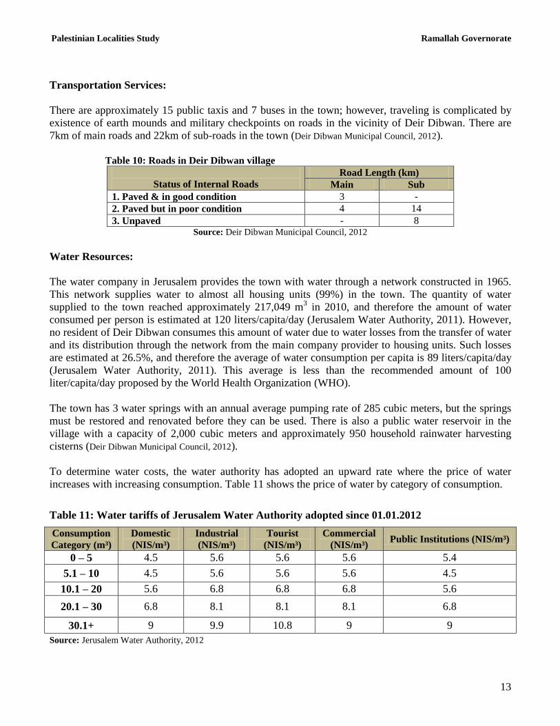
Transportation Services:
There are approximately 15 public taxis and 7 buses in the town; however, traveling is complicated by
existence of earth mounds and military checkpoints on roads in the vicinity of Deir Dibwan. There are
7km of main roads and 22km of sub-roads in the town (Deir Dibwan Municipal Council, 2012).
Table 10: Roads in Deir Dibwan village
Status of Internal Roads
Road Length (km)
Main Sub
1. Paved & in good condition 3 -
2. Paved but in poor condition 4 14
3. Unpaved - 8 Source: Deir Dibwan Municipal Council, 2012
Water Resources:
The water company in Jerusalem provides the town with water through a network constructed in 1965.
This network supplies water to almost all housing units (99%) in the town. The quantity of water
supplied to the town reached approximately 217,049 m3 in 2010, and therefore the amount of water
consumed per person is estimated at 120 liters/capita/day (Jerusalem Water Authority, 2011). However,
no resident of Deir Dibwan consumes this amount of water due to water losses from the transfer of water
and its distribution through the network from the main company provider to housing units. Such losses
are estimated at 26.5%, and therefore the average of water consumption per capita is 89 liters/capita/day
(Jerusalem Water Authority, 2011). This average is less than the recommended amount of 100
liter/capita/day proposed by the World Health Organization (WHO).
The town has 3 water springs with an annual average pumping rate of 285 cubic meters, but the springs
must be restored and renovated before they can be used. There is also a public water reservoir in the
village with a capacity of 2,000 cubic meters and approximately 950 household rainwater harvesting
cisterns (Deir Dibwan Municipal Council, 2012).
To determine water costs, the water authority has adopted an upward rate where the price of water
increases with increasing consumption. Table 11 shows the price of water by category of consumption.
Table 11: Water tariffs of Jerusalem Water Authority adopted since 01.01.2012
Consumption
Category (m³)
Domestic
(NIS/m³)
Industrial
(NIS/m³)
Tourist
(NIS/m³)
Commercial
(NIS/m³) Public Institutions (NIS/m³)
0 – 5 4.5 5.6 5.6 5.6 5.4
5.1 – 10 4.5 5.6 5.6 5.6 4.5
10.1 – 20 5.6 6.8 6.8 6.8 5.6
20.1 – 30 6.8 8.1 8.1 8.1 6.8
30.1+ 9 9.9 10.8 9 9
Source: Jerusalem Water Authority, 2012

Palestinian Localities Study Ramallah Governorate
14
Sanitation:
Deir Dibwan town lacks a public sewerage network with most of the town residents using cesspits and
endocrines as their main means of wastewater disposal (Deir Dibwan Municipal Council, 2012).
Based on the estimated daily per capita water consumption, the estimated amount of wastewater
generated per day is approximately 350 cubic meters or 128,000 cubic meters annually. At the
individual level in the town, it is estimated that per capita wastewater generation is approximately 62
liters per day (ARIJ WERU, 2012). The wastewater collected by cesspits is discharged by wastewater
tankers directly to open areas or nearby valleys without concern for the environment. There is no
wastewater treatment either at the source or at the disposal sites and this poses a serious threat to the
environment and to public health.
Solid Waste Management:
Deir Dibwan Municipal Council is responsible for the collection and disposal of solid waste generated
by citizens and establishments in the town. As the process of solid waste management is costly, a
monthly fee of between 25 and 75 NIS is charged to the population served by domestic solid waste
collection and transportation services. However, the collected fees are not sufficient for good solid waste
management; only 50% of these fees are collected from the citizens (Deir Dibwan Municipal Council, 2012).
Most of the population in Deir Dibwan benefit from the solid waste services, where waste is collected
from households, institutions, shops, and public squares in plastic bags. Deir Dibwan Municipal Council
collects the solid waste three times a week and transports it using a waste vehicle to a dumping site 3km
from the town, where it is burnt and buried (Deir Dibwan Municipal Council, 2012).
The daily per capita rate of solid waste production in Deir Dibwan is 1.05kg. Thus the estimated amount
of solid waste produced per day from the Deir Dibwan residents is nearly 5.2 tons, or 1892 tons per year
(ARIJ WERU, 2012).
Environmental Conditions
Like other villages and towns in the governorate, Deir Dibwan experiences several environmental
problems which must be addressed and solved. These problems can be identified as follows:
Water Crisis
Water is cut off by the Jerusalem Water Authority for long periods of time in several
neighborhoods of the town for several reasons:
(1) Israeli control over Palestinian water resources. Consequently, the Jerusalem Water
Authority purchases water from the Israeli company of Mekorot in order to satisfy residents'
needs.
(2) High rate of water losses, because the water network is old and in need of rehabilitation and
renovation.

Palestinian Localities Study Ramallah Governorate
15
Wastewater Management
The absence of a public sewage network means that in Deir Dibwan residents are forced to use
unhygienic cesspits and endocrines for the disposal of wastewater, and/or to discharge
wastewater in the streets. This is particularly common in winter, as citizens cannot afford the
high cost of sewage tankers during this period. These methods facilitate environmental damage,
health problems, and the spread of epidemics and diseases in the town. This wastewater also
contaminates the groundwater because most cesspits are built without lining, allowing
wastewater to enter into the ground and avoiding the need to use sewage tankers. The untreated
wastewater collected from cesspits by sewage tankers is disposed of in open areas without
concern for the damage it causes to the environment and to residents' health.
Solid Waste Management:
The lack of a central sanitary landfill to serve in Deir Dibwan and the other neighboring
communities in the governorate is due mainly to the obstacles created by the Israeli authorities
for local and national institutions in granting licenses to establish such a landfill, because the
appropriate land is within Area C and under Israeli control. Additionally, the implementation of
such projects depends on funding from donor countries. The lack of a sanitary landfill is a source
of pollution to the groundwater and soil through the leachate produced from the solid waste, and
produces bad odors and distortion of the landscape
Impact of the Israeli Occupation
Geopolitical status in Deir Dibwan
According to the Oslo II Interim Agreement signed between the Palestinian Liberation Organization
(PLO) and Israel on 28th
September 1995, Deir Dibwan was divided into politically classified areas “A”,
“B” and “C”. Approximately 172 dunums (0.2% of the town‟s total area) are assigned as area A where
the Palestinian National Authority (PNA) holds all responsibilities for internal security and Public order,
whilst 12,487 dunums (16.8% of the town‟s total area) are classified as area B where the PNA has
complete control over civil matters and Israel continues to have overriding responsibility for security.
Area B currently constitutes most of the inhabited Palestinian areas, including municipalities, towns and
some refugee camps. It is noted that the entirety of the town‟s population resides in area B. The
remainder of the town‟s land area, constituting 61,630 dunums (83% of the total area), is classified as
area C, where Israel retains full control over security and administration related to the territory (table
12). In area C Palestinian building and land management is prohibited unless through consent or
authorization by the Israeli Civil Administration. The majority of lands lying within the area C of
which its largest part extends to the eastern slopes towards Jericho Governorate are mainly open spaces,
in addition to Israeli settlements and military camps and small agricultural areas.

Palestinian Localities Study Ramallah Governorate
16
Table 12: The Geopolitical Divisions of Deir Dibwan Town according to the Oslo II Interim Agreement
Percent of Total town area Area in dunums Area
0.2 172 Area A
16.8 12487 Area B
83 61630 Area C
0 0 Nature Reserve
100 74289 Total
Source: Source: ARIJ-GIS, 2011
Deir Dibwan Town and the Israeli Occupation
Deir Dibwan town has been subjected to a number of Israeli led land confiscations for the benefit of the
various Israeli ends, represented in the construction of settlements, military bases, outposts and Israeli
bypass roads on the town territories, in addition to the establishment of numerous Israeli barriers,
restricting freedom of movement to villagers. That which follows is a breakdown of the Israeli
confiscations to have negatively impacted Deir Dibwan town territories:
Israeli Occupation Forces (IOF) confiscated 1,052 dunums in Deir Dibwan for the establishment of
several Israeli military bases on its eastern located lands. . Through the establishment of such military
bases in the heart of Palestinian territories, IOF are aiming at intensifying both their military and
security presence within Palestine, thus increasing control over Palestinian citizens Further lands have
also been confiscated (approx. 1287 dunums) in Deir Dibwan to build „Ma‟ale Mikhmas‟ settlement
southeast of the town. Today, the settlement which was established in 1981 is inhabited by 1,261 Israeli
settlers.
Attacks carried out by Israeli settlers living in the illegal settlements around Deir Dibwan have had a
serious and significant impact on both the town‟s residents and their properties. These attacks allow
settlers to control Palestinian land adjacent to the settlements by preventing landowners from gaining
access to it. Settlers near Deir Dibwan have enclosed land using barbed wire and planting trees to
increase their control over these locations Settlers have further burnt and uprooted trees planted and
owned by Palestinians and attacked landowners to intimidate and deter them from returning to their
lands nearby to the aforementioned settlements.
In addition, the Israeli Government has over time confiscated thousands of agricultural and non-
agricultural lands to open several bypass roads that stretch thousands of kilometers from the north to the
south of the West Bank. This has been carried out with the purpose of linking Israeli settlements with
one another dividing Palestinian lands and enhancing security control over it. Israel has additionally
confiscated further land from Deir Dibwan and lands to its east and south for the construction of 4 Israeli
bypass roads; numbers 60, 457, 458 and 446. The total length of these roads stretches for 20.2km over
Deir Dibwan lands. However, the real threat of bypass roads such as those aforementioned lies in the
buffer zone formed by the Israeli Occupation Force (IOF) alongside these roads, extending
approximately 75 m on each side. These buffer zones dramatically increase the total area of land
confiscated by the construction of bypass roads.
Following the outbreak of the second Palestinian Intifada during September 2000, the IOF constructed
hundreds of military checkpoint within the West Bank. In Deir Dibwan, three earth mound barriers were
Palestinian Localities Study Ramallah Governorate
17
constructed on sub entrances located to the southeastern side of the town, on bypass road 457. This was
carried out with the intention of preventing Palestinians from using this road. It is noted that that Deir
Dibwan is connected with Ramallah city through a tunnel that passes underneath bypass road 60,
through Beitin, „Ein Yabrud and Dura al Qar‟ villages. This tunnel additionally links the eastern areas of
the governorate with Ramallah city. Moreover, occupation forces established a permanent military
checkpoint near Beit El settlement bloc west of Beitin village, which neighbors Deir Dibwan from the
south. This checkpoint has forced residents of Deir Dibwan and other neighboring villages to pass
through the aforementioned villages then return to Ramallah city, in order to avoid this checkpoint
which has been closed to Palestinians for many years. The restriction of access in this way was done
under the Israeli rationale of had protecting settlers using the nearby bypass road in addition to
confiscating further village lands.
Deir Dibwan has experienced forcible land seizure for the establishment of 3 outposts on the
southeastern side of the town, in the area surrounding „Ma‟ale Mikhmas‟ Israeli settlement. These
outposts are named as; Mitzpe Danny, North Ma‟ale Mikhmas and Far North Ma‟ale Mikhmas. These
outposts aim at expanding Ma‟ale Mikhmas settlement through the control of further Palestinian lands.
It is further noted that during the past two decades, Israel has constructed 232 outposts in the West Bank,
which are considered to be the nucleus for new settlement development. Outposts are composed of
mobile caravans that are located on lands stolen by settlers and represent a contiguity of a nearby mother
settlement. It is worth mentioning that the epidemic of Israeli outposts started with a “Sharonian1” call
for Jewish settlers to take control of Palestinian hilltops to prevent transferring them to Palestinians in
negotiations. Although the successive Israeli governments haven‟t legalized this phenomenon, they have
managed to find both security and logistical cover to justify the act, its existence and continuity. After
2001 the Prime Minister of the time, Ariel Sharon, unleashed the expansion of outposts which has led to
a significant increase in the number of outposts within Palestinian areas. To this day, the construction
and expansion of outposts has been undertaken with the full support of IOF which have assisted Israeli
settlers in moving and settling in outposts, in addition to protecting and providing them with the
necessary infrastructure to guarantee their continued existence.
Israel's Demolition Policy Sweeps Deir Dibwan Town
Arab al Malihat locality east of Deir Dibwan belongs to Deir Dibwan town citizens in Maghayer ad Deir
area, and is considered the second largest gathering for Arab al Malihat in the West Bank after the first
gathering which is located in Al Mu‟arrajat area. Arab al Malihat residents live in tents and houses
constructed from zinc (tin) and depend upon sheep herding as their main livelihood. This tribe has been
living in the area since about 35 years.
Since the early 1980s eighties the Israeli army came to the site of the Aran al Malihat Bedouin tribe who
used to live in Al „Araqa area of Deir Dibwan, 7km to the east from the tribe‟s current location. The
army forced its inhabitants to evacuate the area claiming it to be a location reserved from military
training. Since this displacement more than twenty years ago, Arab al Malihat tribe has been residing in
its current aforementioned location without any reluctance and in a stable condition. During this time,
the Israeli Civil Administration through the Ministry of Education established a mobile school for local
residents entitled the „Canaanite Bedouin Co-educated Elementary School.‟ In addition, a water line
1 As instigated by former Israeli Prime Minister „Ariel Sharon‟ (2001-2006)

Palestinian Localities Study Ramallah Governorate
18
provided by the Israeli Company „Mekorot‟ has been extended to supply the region with clean drinking
water.
Following the Oslo II (1995), the area on which Arab al Malihat resides was classified as area C, which
is subjected to full Israeli security and administrative control, thus, inhabitants of this area were
considered illegal residents due to their lack of necessary licenses to reside in the region, provided by the
Israeli Civil Administration. During early September 2008, IOF visited Beit El area to hand over a
number of eviction notifications to families, notifying families they have one month to evict their
homes. The families notified and threatened with demolition submitted an objection to the Israeli Civil
Administration in Beit El, however, since the objection, the families have not received any written or
even oral reply.
The threat of demolitions has continued to surround Arab al Malihat tribe. During October 2008,
without any previous warning and before an official decision on the part of the Israeli Supreme Court,
Israeli „Organizational Forces‟ in Beit El, supported and guarded by soldiers, police and Israeli
bulldozers, demolished the homes, living and animal barracks of the tribe. The damages and losses were
counted at 37 facilities; of which approximately 14 were sheep barracks and 23 living barracks. The area
of the demolished barracks ranges between 72 m² and 108 m².
Development Plans and Projects
Implemented Projects
Deir Dibwan Municipal Council has implemented several development projects in Deir Dibwan during
the last five years as shown in Table 13.
Table 13: Implemented Development Plans and Projects in Deir Dibwan during the Past 5 Years
Name of the Project
Type Year Donor
Rehabilitating and paving the main street Infrastructure 2007 Islamic Development Bank
Paving internal roads Infrastructure 2009 Municipal Fund
Paving the health center road Infrastructure 2010 Municipal Fund
Paving Deir Dibwan/ Rammun road Infrastructure 2011 USAID
Renovating the water network Infrastructure 2012 Jerusalem Water Authority Source: Deir Dibwan Municipal Council, 2012

Palestinian Localities Study Ramallah Governorate
19
Proposed Projects
Deir Dibwan Municipal Council, in cooperation with the civil society organizations in the town and the
town residents, hopes to implement several projects in the coming years. The project ideas were
developed during the PRA workshop conducted by ARIJ staff in the town. The projects are as follows,
in order of priority from the viewpoint of the participants in the workshop:
1. Renewing the structural plan of the town.
2. Establishing a sewage network (approximately 25 km) to be connected to all housing units of the
town in order to reduce environmental pollution.
3. Rehabilitating 10 km of internal roads of pavement, construction of sidewalks and provision of
lightings, in addition to constructing another 10 km of internal roads.
4. Establishing an industrial zone to include all professional stores and workshops for blacksmiths
and carpenters.
5. Rehabilitating and developing Ash Sheikh Ammar Park to become a public and an amusement
park that serves all age groups in the town.
6. Supplying the town‟s clinic with medical equipments and hiring additional staff in order to
provide appropriate medical services to residents of the town and neighboring villages on a 24
hour basis.
7. Establishing a sport, social, and cultural center with a playground.

Palestinian Localities Study Ramallah Governorate
20
Locality Development Priorities and Needs
Deir Dibwan suffers from a significant shortage of infrastructure and services. Table 14 shows the
development priorities and needs in the town according to the Municipality Council's perspective.
Table 14: Development Priorities and Needs in Deir Dibwan No. Sector Strongly
Needed
Needed Not a
Priority
Notes
Infrastructural Needs
1 Opening and Pavement of Roads * 29 km*
2 Rehabilitation of Old Water Networks * 10 km
3 Extending the Water Network to Cover New Built up
Areas * 2 km
4 Construction of New Water Networks * 2 km
5 Rehabilitation/ Construction of New Wells or
Springs * 2 springs
6 Construction of Water Reservoirs *
7 Construction of a Sewage Disposal Network * 20 km
8 Construction of a New Electricity Network *
9 Providing Containers for Solid Waste Collection * 50 containers
10 Providing Vehicles for Collecting Solid Waste *
11 Providing a Sanitary Landfill *
Health Needs
1 Building of New Clinics or Health Care Centres *
2 Rehabilitation of Old Clinics or Health Care Centres * 2 health centers
3 Purchasing of Medical Equipment and Tools *
Educational Needs
1 Building of New Schools *
2 Rehabilitation of Old Schools *
3 Purchasing of New Equipment for Schools *
Agriculture Needs
1 Rehabilitation of Agricultural Lands * 500 dunums
2 Building Rainwater Harvesting Cisterns * 100 cisterns
3 Construction of Barracks for Livestock * 20 barracks
4 Veterinary Services *
5 Seeds and Hay for Animals * 11,000 tons by year
6 Construction of New Greenhouses *
7 Rehabilitation of Greenhouses *
8 Field Crops Seeds *
9 Plants and Agricultural Supplies * * 7km are main roads, 14km are internal roads and 8km are agricultural roads.
Source: Deir Dibwan Municipal Council, 2012

Palestinian Localities Study Ramallah Governorate
21
References:
Applied Research Institute - Jerusalem (ARIJ), 2012. Geographic Information Systems and
Remote Sensing Unit; Land Use Analysis (2010) – Half Meter High Accuracy. Bethlehem -
Palestine.
Applied Research Institute - Jerusalem (ARIJ), 2012. Geographic Information Systems and
Remote Sensing unit Database. Bethlehem - Palestine.
Applied Research Institute - Jerusalem (ARIJ). 2012. Water & Environment Research Unit
Database (WERU). Bethlehem - Palestine.
Deir Dibwan Municipal Council, 2012.
Jerusalem Water Authority (for Ramallah & Al Bireh areas) (2011). Detection showing the
amount of water sold from 1/1/2010 till 31/12/2010. Ramallah – Palestine.
Jerusalem Water Authority (2012). Jerusalem Water Authority's Website; Data Retrieved on the
first of March. http://www.jwu.org/newweb/atemplate.php?id=87.
Ministry of Education & Higher Education (MOHE) - Ramallah, 2011. Directorate of Education;
A database of schools (2010/2011). Ramallah – Palestine.
Palestinian Central Bureau of Statistics. 2009. Ramallah, Palestine: General Census of
Population and Housing Censuses, 2007.
Palestinian Ministry of Agriculture (MOA), 2009. Directorate of Agriculture data (2008/2009).
Ramallah – Palestine.