Debris flow-dominated and rockfall-dominated talus …lewebb/CCLI/various papers/Sass and... ·...
17
Debris flow-dominated and rockfall-dominated talus slopes: Genetic models derived from GPR measurements O. Sass a, ⁎ , M. Krautblatter b a Institut für Geographie, Universität Augsburg, Universitätsstr. 10, 86135 Augsburg, Germany b Geographisches Institut der Universität Bonn, Meckenheimer Allee 166, 53115 Bonn, Germany Received 9 March 2006; received in revised form 9 August 2006; accepted 30 August 2006 Available online 12 October 2006 Abstract Stratified talus deposits are reported from many different mountain environments. Numerous possible explanations are discussed in the literature; however, the sediment stores are rarely accessible as exposures are sparse. We applied ground- penetrating radar (25, 50 and 100 MHz antennae) to gain insight into the internal sediment structures of 23 alpine scree slopes; ten examples are presented in this paper. The study areas are spread over the Eastern European Alps at altitudes ranging from 1500 to 2900 m. The bedrock type is primarily limestone and dolostone; one area is composed of gneiss and mica–schist. GPR turned out to be highly suitable for investigating sediment structures of dry talus debris. The results showed that almost all of the deposits investigated are characterized by pronounced stratification. Several different types of layering were identified. Discordant layers which are restricted to confined parts of the talus are probably related to sediment redistribution processes like surficial debris flows or dry grain flows. These features frequently occur at the uppermost part of the slope caused by overland flow from the adjacent rock face, but may also develop in the downhill part of a talus. One talus in the Reintal area showed surface- parallel, persistent layers of different grain sizes which cannot be explained by any known models. We suggest a novel model of talus development which is driven by climatic fluctuations. In periods of enhanced freeze–thaw activity like the Little Ice Age, the delivery of coarse debris prevails. In warmer climate with a higher frequency of rainstorms, the depletion of finer-grained intermediate stores in less inclined rockwall positions leads to delivery of clasts smaller than 2 cm. The type of layering found within a talus is determined by rockwall parameters like height, steepness, topography and dissection of the rock face. The “storage depletion” model applies to high rockwalls with a considerable volume of intermediate storage. © 2006 Elsevier B.V. All rights reserved. Keywords: Talus; Rockfall; Ground-penetrating radar; Stratified scree 1. Introduction Talus deposits in steepland areas collect detached mate- rial from adjacent rockwalls and thus, represent the first step in the alpine sediment cascade. Traditional models explain talus evolution as an evolving phenomenon of debris fall activity (0–10 m 3 )(Whalley, 1984) in response to infinitesimal rockwall retreat (Hutchinson, 1998). If talus slopes are situated in closed basins, e.g. behind moraine ridges, they act as archives of backweathering. Despite this rather straightforward geographical setting, talus deposits are complex sediment stores documenting the transition from Late-Glacial to Holocene sedimentation history as well as process fluctuations within the Holocene. Changes Geomorphology 86 (2007) 176 – 192 www.elsevier.com/locate/geomorph ⁎ Corresponding author. Tel.: +49 821 598 2279; fax: +49 821 598 2264. E-mail address: [email protected] (O. Sass). 0169-555X/$ - see front matter © 2006 Elsevier B.V. All rights reserved. doi:10.1016/j.geomorph.2006.08.012
Transcript of Debris flow-dominated and rockfall-dominated talus …lewebb/CCLI/various papers/Sass and... ·...

2007) 176–192www.elsevier.com/locate/geomorph
Geomorphology 86 (
Debris flow-dominated and rockfall-dominated talus slopes:Genetic models derived from GPR measurements
O. Sass a,⁎, M. Krautblatter b
a Institut für Geographie, Universität Augsburg, Universitätsstr. 10, 86135 Augsburg, Germanyb Geographisches Institut der Universität Bonn, Meckenheimer Allee 166, 53115 Bonn, Germany
Received 9 March 2006; received in revised form 9 August 2006; accepted 30 August 2006Available online 12 October 2006
Abstract
Stratified talus deposits are reported from many different mountain environments. Numerous possible explanations arediscussed in the literature; however, the sediment stores are rarely accessible as exposures are sparse. We applied ground-penetrating radar (25, 50 and 100 MHz antennae) to gain insight into the internal sediment structures of 23 alpine scree slopes; tenexamples are presented in this paper. The study areas are spread over the Eastern European Alps at altitudes ranging from 1500 to2900 m. The bedrock type is primarily limestone and dolostone; one area is composed of gneiss and mica–schist.
GPR turned out to be highly suitable for investigating sediment structures of dry talus debris. The results showed that almost allof the deposits investigated are characterized by pronounced stratification. Several different types of layering were identified.Discordant layers which are restricted to confined parts of the talus are probably related to sediment redistribution processes likesurficial debris flows or dry grain flows. These features frequently occur at the uppermost part of the slope caused by overland flowfrom the adjacent rock face, but may also develop in the downhill part of a talus. One talus in the Reintal area showed surface-parallel, persistent layers of different grain sizes which cannot be explained by any known models. We suggest a novel model oftalus development which is driven by climatic fluctuations. In periods of enhanced freeze–thaw activity like the Little Ice Age, thedelivery of coarse debris prevails. In warmer climate with a higher frequency of rainstorms, the depletion of finer-grainedintermediate stores in less inclined rockwall positions leads to delivery of clasts smaller than 2 cm. The type of layering foundwithin a talus is determined by rockwall parameters like height, steepness, topography and dissection of the rock face. The “storagedepletion” model applies to high rockwalls with a considerable volume of intermediate storage.© 2006 Elsevier B.V. All rights reserved.
Keywords: Talus; Rockfall; Ground-penetrating radar; Stratified scree
1. Introduction
Talus deposits in steepland areas collect detached mate-rial fromadjacent rockwalls and thus, represent the first stepin the alpine sediment cascade. Traditional models explain
⁎ Corresponding author. Tel.: +49 821 598 2279; fax: +49 821 5982264.
E-mail address: [email protected] (O. Sass).
0169-555X/$ - see front matter © 2006 Elsevier B.V. All rights reserved.doi:10.1016/j.geomorph.2006.08.012
talus evolution as an evolving phenomenon of debris fallactivity (0–10 m3) (Whalley, 1984) in response toinfinitesimal rockwall retreat (Hutchinson, 1998). If talusslopes are situated in closed basins, e.g. behind moraineridges, they act as archives of backweathering. Despite thisrather straightforward geographical setting, talus depositsare complex sediment stores documenting the transitionfrom Late-Glacial to Holocene sedimentation history aswell as process fluctuations within the Holocene. Changes

Table 1Geographical setting of the study sites
Area Lithology Elevation [m] No. slopes GPR frequency[MHz]
Arnspitze Limestone 1200–1900 2 50, 100, 200Dammkar Limestone 1600–2100 2 25Hoher Ifen Limestone 1900–2200 1 25Reintal Limestone 1200–2000 4 25, 50, 100Zugspitze Limestone 2400–2900 2 25, 100Parzinn Dolostone 2100–2700 3 25, 50Tegelberg Dolostone 1500–1800 2 25, 50Wolfebner
KarDolostone 2100–2500 2 25, 100
Kühtai Gneiss/mica-s.
2400–2800 5 25, 50
Fig. 1. Location of study sites in the Eastern European Alps.
177O. Sass, M. Krautblatter / Geomorphology 86 (2007) 176–192
in the processes and intensity of rockfall generation andsubsequent debris redistribution lead to more or less pro-nounced stratification of talus deposits.
Stratified scree deposits are reported from a steadilyincreasing number of different mountain environments.Whereas stacked debris was first investigated in the FrenchPyrenees (Guillien, 1951), recent work has describedsimilar deposits in temperate upland environments (Fran-cou, 1990; Van Steijn, 1997; Gengnian et al., 1999;Hinchcliffe, 1999; Garcia-Ruiz et al., 2001) as well as incold temperate environments worldwide (Bilkra andNemec, 1998; Hétu and Gray, 2000). Stratified screeslopes are not only confined to high mountain regions, butalso occur in vegetated upland environments (Bertran andTexier, 1999; Harris and Prick, 2000; Curry and Black,2002). In these studies attention is paid to the question ofwhether the scree strata correspond to climatic fluctuationsduring the Pleistocene Pleniglacials, the Lateglacial and theHolocene.
Field assessment, laboratory studies and theoreticalmodelling approaches have established a number ofpost-depositional processes that can be responsible forthe formation of stratified scree. In the view of mostauthors, the strata in scree deposits are a result ofredistribution and sorting processes after a homoge-
neous rockfall deposition. Spatial particle sorting bydebris flows is one of the oldest explanations forstratified slope deposits (Guillien, 1951). The frequentoccurrence of debris-saturated flows on a scree slopecan lead to alternating layers of channel, levee andlobe deposits of different debris flow events (VanSteijn, 1988; Bertran and Texier, 1994; Blair, 1999).The stratification of debris flow deposits is often notclearly developed and rather branded by openwork
178 O. Sass, M. Krautblatter / Geomorphology 86 (2007) 176–192
lenses in the proximal part, and by diamicton lenses inthe distal part in the dimensions of a few meters (VanSteijn et al., 1995).
Dry grain flows, which provide a further explanation forstratification, are usually initiated by rockfall, gradualloading or over-steepening of talus deposits and culminatein a flow of cohesionless clast material maintained bydispersive forces of particle collisions (Lowe, 1976). Theflows move with a speed of 0.5–2 m s−1 and are usuallysome tens of centimetres in width and some metres inlength. Due to the effects of kinematic sieving (Carniel andScheidegger, 1974) and the vertical increase in the speed ofthe flow movement, coarse-grained particles are sortedtowards the front and upper part of the flow, while the grainsize decreases in the lower and back parts of the flowdeposit.
Supranival sliding processes have been described asstratification processes (Hétu and Vandelac, 1989; Hétu,1991, 1995). These processes lead to stratifications ex-clusively at the bottom of the scree slopes, mostly inprotected zones at the intersection of debris cones.Supranival sliding of debris can deposit coarse-grained
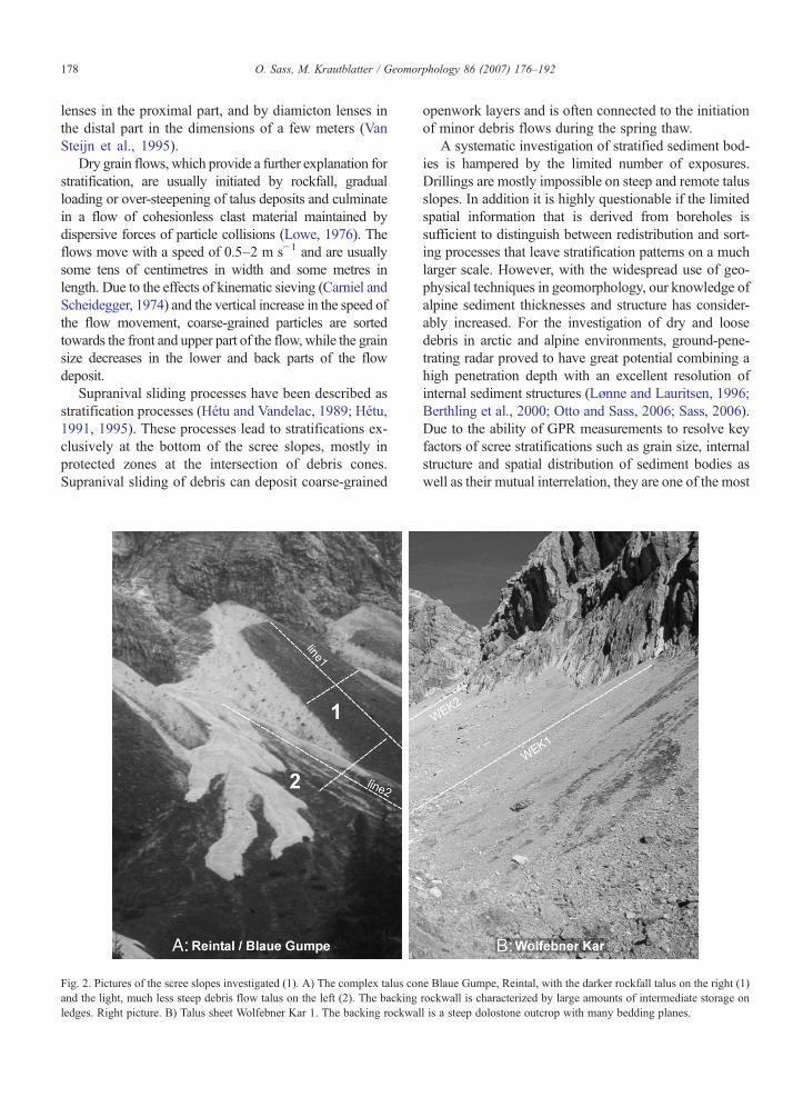
Fig. 2. Pictures of the scree slopes investigated (1). A) The complex talus conand the light, much less steep debris flow talus on the left (2). The backingledges. Right picture. B) Talus sheet Wolfebner Kar 1. The backing rockwa
openwork layers and is often connected to the initiationof minor debris flows during the spring thaw.
A systematic investigation of stratified sediment bod-ies is hampered by the limited number of exposures.Drillings are mostly impossible on steep and remote talusslopes. In addition it is highly questionable if the limitedspatial information that is derived from boreholes issufficient to distinguish between redistribution and sort-ing processes that leave stratification patterns on a muchlarger scale. However, with the widespread use of geo-physical techniques in geomorphology, our knowledge ofalpine sediment thicknesses and structure has consider-ably increased. For the investigation of dry and loosedebris in arctic and alpine environments, ground-pene-trating radar proved to have great potential combining ahigh penetration depth with an excellent resolution ofinternal sediment structures (Lønne and Lauritsen, 1996;Berthling et al., 2000; Otto and Sass, 2006; Sass, 2006).Due to the ability of GPR measurements to resolve keyfactors of scree stratifications such as grain size, internalstructure and spatial distribution of sediment bodies aswell as their mutual interrelation, they are one of the most
e Blaue Gumpe, Reintal, with the darker rockfall talus on the right (1)rockwall is characterized by large amounts of intermediate storage onll is a steep dolostone outcrop with many bedding planes.
179O. Sass, M. Krautblatter / Geomorphology 86 (2007) 176–192
promising geophysical methods for future investigations.Thus, the key questions of this contribution can besummarized as follows:
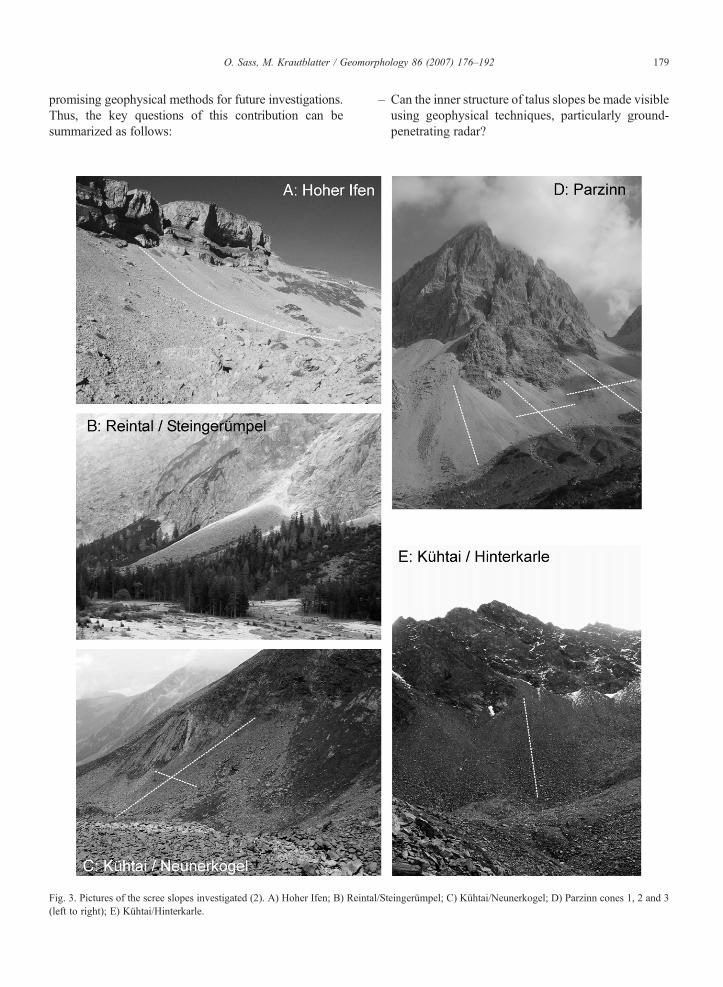
Fig. 3. Pictures of the scree slopes investigated (2). A) Hoher Ifen; B) Reinta(left to right); E) Kühtai/Hinterkarle.
– Can the inner structure of talus slopes be made visibleusing geophysical techniques, particularly ground-penetrating radar?
l/Steingerümpel; C) Kühtai/Neunerkogel; D) Parzinn cones 1, 2 and 3
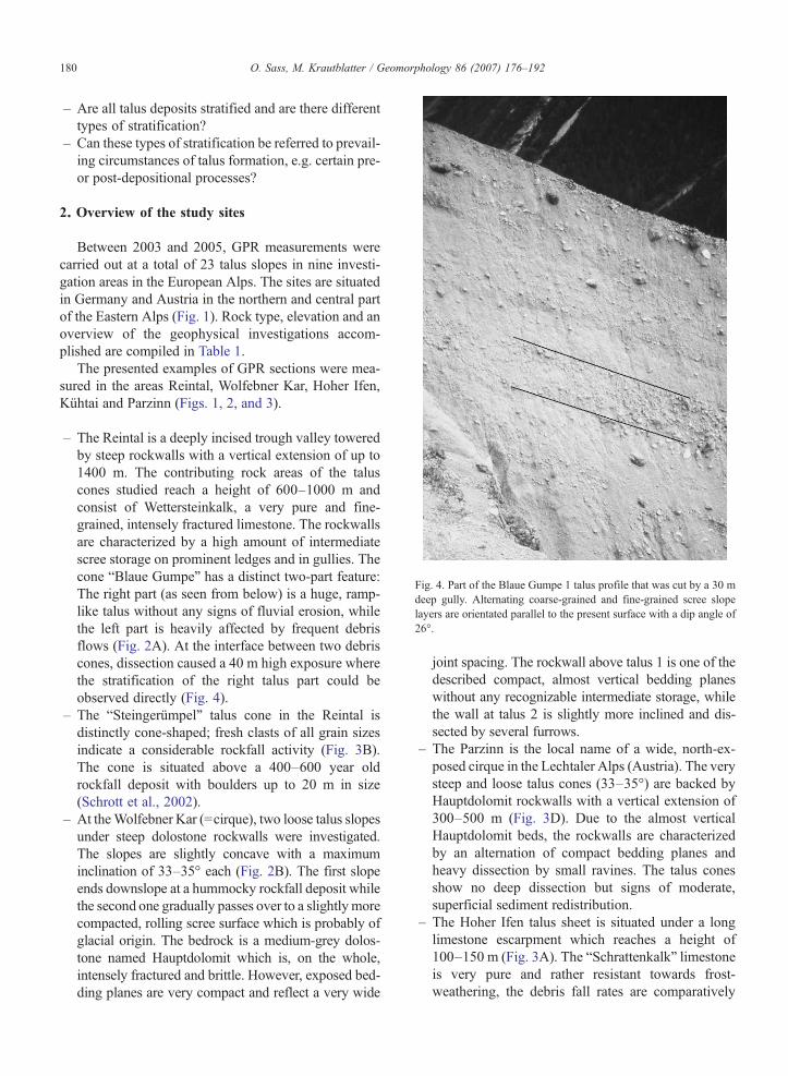
Fig. 4. Part of the Blaue Gumpe 1 talus profile that was cut by a 30 mdeep gully. Alternating coarse-grained and fine-grained scree slopelayers are orientated parallel to the present surface with a dip angle of26°.
180 O. Sass, M. Krautblatter / Geomorphology 86 (2007) 176–192
– Are all talus deposits stratified and are there differenttypes of stratification?
– Can these types of stratification be referred to prevail-ing circumstances of talus formation, e.g. certain pre-or post-depositional processes?
2. Overview of the study sites
Between 2003 and 2005, GPR measurements werecarried out at a total of 23 talus slopes in nine investi-gation areas in the European Alps. The sites are situatedin Germany and Austria in the northern and central partof the Eastern Alps (Fig. 1). Rock type, elevation and anoverview of the geophysical investigations accom-plished are compiled in Table 1.
The presented examples of GPR sections were mea-sured in the areas Reintal, Wolfebner Kar, Hoher Ifen,Kühtai and Parzinn (Figs. 1, 2, and 3).
– The Reintal is a deeply incised trough valley toweredby steep rockwalls with a vertical extension of up to1400 m. The contributing rock areas of the taluscones studied reach a height of 600–1000 m andconsist of Wettersteinkalk, a very pure and fine-grained, intensely fractured limestone. The rockwallsare characterized by a high amount of intermediatescree storage on prominent ledges and in gullies. Thecone “Blaue Gumpe” has a distinct two-part feature:The right part (as seen from below) is a huge, ramp-like talus without any signs of fluvial erosion, whilethe left part is heavily affected by frequent debrisflows (Fig. 2A). At the interface between two debriscones, dissection caused a 40 m high exposure wherethe stratification of the right talus part could beobserved directly (Fig. 4).
– The “Steingerümpel” talus cone in the Reintal isdistinctly cone-shaped; fresh clasts of all grain sizesindicate a considerable rockfall activity (Fig. 3B).The cone is situated above a 400–600 year oldrockfall deposit with boulders up to 20 m in size(Schrott et al., 2002).
– At theWolfebner Kar (=cirque), two loose talus slopesunder steep dolostone rockwalls were investigated.The slopes are slightly concave with a maximuminclination of 33–35° each (Fig. 2B). The first slopeends downslope at a hummocky rockfall deposit whilethe second one gradually passes over to a slightlymorecompacted, rolling scree surface which is probably ofglacial origin. The bedrock is a medium-grey dolos-tone named Hauptdolomit which is, on the whole,intensely fractured and brittle. However, exposed bed-ding planes are very compact and reflect a very wide
joint spacing. The rockwall above talus 1 is one of thedescribed compact, almost vertical bedding planeswithout any recognizable intermediate storage, whilethe wall at talus 2 is slightly more inclined and dis-sected by several furrows.
– The Parzinn is the local name of a wide, north-ex-posed cirque in the Lechtaler Alps (Austria). The verysteep and loose talus cones (33–35°) are backed byHauptdolomit rockwalls with a vertical extension of300–500 m (Fig. 3D). Due to the almost verticalHauptdolomit beds, the rockwalls are characterizedby an alternation of compact bedding planes andheavy dissection by small ravines. The talus conesshow no deep dissection but signs of moderate,superficial sediment redistribution.
– The Hoher Ifen talus sheet is situated under a longlimestone escarpment which reaches a height of100–150 m (Fig. 3A). The “Schrattenkalk” limestoneis very pure and rather resistant towards frost-weathering, the debris fall rates are comparatively
181O. Sass, M. Krautblatter / Geomorphology 86 (2007) 176–192
low. Along the escarpment medium-sized rockfallsoccur; large, rectangular boulders have accumulatedin a small valley at the foot of the talus sheet.
– The lithology of the Kühtai area is characterized byparagneiss and mica–schist rockwalls (Fig. 3C,E).The gneissic rock outcrops have a rather wide jointspacing (ca. 1 m) and a very low debris fall activity(Sass, 2005). The grain size distribution on thesurface of the talus slopes is dominated by bothcoarse rockfall debris (few decimetres) and clasts ofboulder size (approx. 1–2 m). The top positions ofthe talus cones are dominated by fresh rockfallmaterial, while the debris near the talus foot and mostof the boulders are lichen-covered. The rockwalls atmica–schist outcrops (Plenderlesee, Neunerkogel)show a slightly higher joint density and producesmaller clasts.
Details on rockwall and slope parameters are shownin Table 2. However, each rock face and each talus has an
Table 2Parameters of the rockwalls and talus slopes investigated
Rockwall
Height(m)
Slopeangle (°)
Stepped(ledges)
Dissection(furrows)
Joispa
Reintal Gumpe Line1 700 50 (17–90) High Moderate 0.Gumpe Line2 700 50 (17–90) High Moderateb 0.Steingerümpel 1000 60 (25–90) Moderate Lowd 0.HintereGumpe 1
1200 55 (15–90) High Moderate 0.
Kühtai Neunerkogel 200 55 Moderate Moderate 0.Plenderlesee 200 45 Low High 0.Vorderkarle 1 160 61 Moderate Moderate 0.Vorderkarle 2 100 53 Moderate High 0.Hinterkarle 250 51,5 Moderate High 0.
Parzinn Cone 1 280 50,5 Moderate High 0.Cone 2 220 53 Moderate High 0.Cone 3 300 60 Moderate High 0.
Wolf.Kar
Talus 1 170 66 Low Low 0.Talus 2 120 67,5 Low Moderate 0.
Zug-Spitze
SF 1 360 48 Low Low 0.SF 2 220 53,5 Moderate Low 0.
DammKar
Viererkar 1 300 72,5 Low Low 0.Viererkar 2 120 67,5 Low Moderate 0.
Arn-Spitze
Cone 1 400 39 Slope High 0.Cone 3 400 36 Slope High 0.
TegelBerg
Talus 1 160 42,5 High Moderate 0.0Talus 2 60 41 Moderate High 0.0
HoherIfen 2
100 59 Moderate Low 0.
a Slightly bent.b One prominent couloir.c Flattened by debris flows.d Plus bergsturz scarp.e Plus boulders.
individual and unique setting which is hard to summarizein a few parameters. Joint density is extremely variablebetween neighbouring rock sections, ledges and furrowshave very different shapes and sizes. Generally, all grainsizes from sand to boulder occur at every talus slope.Thus, we tried to give the predominant size range.
3. Methods
A RAMACGPR device (Malå Geosystems) equippedwith 25, 50 and 100 MHz antennae was applied tomeasure numerous longitudinal and cross profiles of talusdeposits. Lower frequency surveys result in higher pene-tration depth with less clutter present in the profiles. Onthe other hand, as penetration depth increases, the reso-lution of small objects and layers decreases. Twenty-fivemegahertz profiles proved to be suitable for detecting thetalus base even of large talus cones with a thickness of upto 40–50 m. Using the 50 MHz antennae makes the bestcompromise between resolution of inner structures and
Talus
ntcing
Slopeangle (°)
Slopelength (m)
Grain size(cm)
Shape Layering type(see Table 3)
3–1.0 24–33 270 b5–30 Sheeta 13–1.0 19–24 270 b5–20 D.F. conec 23–1.0 25 200 b5–30e Cone 5 (4, 1)3–1.0 30–34 300 b5–30 Cone 1
3–1.0 28–32 130 5–50e Sheet 3b (4)3–1.0 31 230 b5–30 Cone 1?, 3b3–3.0 30 110 10–100e Cone 3b (4)3–3.0 33 140 10–100e Cone 3b (4)3–3.0 29 290 10–50e Cone 51–0.3 30–32 350 b5–30 Cone 31–0.3 31–35 150 b5–30 Cone 31–0.3 31–35 330 b5–30 Cone 1, 31–3.0 30–34 110 b5–20e Sheet 4, 3a1–0.3 30–34 140 b5–20 Sheet 3, 1?1–0.3 31 175 b5–20 Sheeta 11–0.3 34,5 210 b5–20 Sheet 31–0.3 34 120 b5–30 Sheet 41–1.0 31 80 b5–30 Cone 41–1.0 35 60 b5–20 Cone 31–1.0 28–33 250 b5–20 D.F. conec 23–0.3 25–30 170 b5–20 Sheet 33–0.3 20–30 140 b5–20 Sheeta 3a3–3.0 32 200 10–30e Sheet 4, 5
182 O. Sass, M. Krautblatter / Geomorphology 86 (2007) 176–192
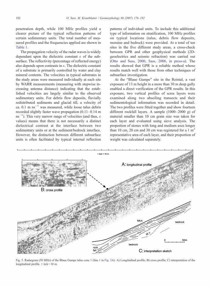
penetration depth, while 100 MHz profiles yield aclearer picture of the typical reflection patterns ofcertain sedimentary units. The total number of mea-sured profiles and the frequencies applied are shown inTable 1.
The propagation velocity of the radar waves is widelydependant upon the dielectric constant ε of the sub-surface. The reflectivity (percentage of reflected energy)also depends upon contrasts in ε. The dielectric constantof a substrate is primarily controlled by water and claymineral contents. The velocities in typical substrates inthe study areas were measured individually at each siteby WARR measurements (measuring with stepwise in-creasing antenna distance) indicating that the estab-lished velocities are largely similar to the observedsedimentary units. For debris flow deposits, fluviallyredistributed sediments and glacial till, a velocity ofca. 0.1 m ns−1 was measured, while loose talus debrisrecorded slightly faster wave propagation (0.11–0.14 mns−1). This very narrow range of velocities (and thus, εvalues) means that there is not necessarily a distinctdielectrical contrast at the interface between twosedimentary units or at the sediment/bedrock interface.However, the distinction between different subsurfaceunits is often facilitated by typical internal reflection
Fig. 5. Radargram (50 MHz) of the Blaue Gumpe talus cone 1 (line 1 in Fig.longitudinal profile. 1 tick=10 m.
patterns of individual units. To include this additionaltype of information on stratification, 100 MHz profileson typical locations (talus, debris flow deposits,moraine and bedrock) were provided. At a total of tensites in the five different study areas, a cross-checkbetween GPR and other geophysical methods (2D-geoelectrics and seismic refraction) was carried out(Otto and Sass, 2006; Sass, 2006, in press-a). Theresults showed that GPR is a reliable method whoseresults match well with those from other techniques ofsubsurface investigation.
At the “Blaue Gumpe” site in the Reintal, a vastexposure of 13 m height in a more than 30 m deep gullyenabled a direct verification of the GPR results. In thisexposure, two vertical profiles of scree layers wereexamined along two abseiling transects and theirsedimentological information was recorded in detail.The two profiles were fitted together and show fourteendifferent rockfall layers. A sample (1000–2000 g) ofmaterial smaller than 10 cm grain size was taken foreach layer and evaluated using sieve analysis. Theproportion of stones with long and medium axes longerthan 10 cm, 20 cm and 30 cm was registered for a 1 m2
representative area of each layer, and their proportion ofweight was calculated separately.
2A). A) Longitudinal profile; B) cross profile; C) interpretation of the

183O. Sass, M. Krautblatter / Geomorphology 86 (2007) 176–192
4. Results and interpretation
4.1. Complex talus cone “Blaue Gumpe” (Reintal)
Fig. 4 shows the stratified scree deposits at the largeexposure of the Blaue Gumpe cone (left of line 1 inFig. 2A). The layers can only be well assessed on freshlycarved surfaces and are sometimes partly covered bydeposits from upper layers. The stratified layers begin indirect contact with the rock face; at a distance from therock face continuous bedding is found. The typical,0.5–0.7 m thick pronounced coarse-grained layerindicated by the lines in Fig. 4 is a continuous planarlayer. The exposure does not cut the layers in the dipdirection, and the slope angle of a layer alternatesbetween openwork layers and fine-grained layers, soangles and thickness of layers appear slightly distorted.The general dip angle of 26° is almost the same as thepresent orientation of the scree cone.
The layers visible in Fig. 4 vary considerably in grainsize and can easily be attributed to two clearly distinctclusters: 1) coarse-grained layers bearing a weightproportion of more than 70% of particles larger than2 cm, and 2) fine-grained layers with a proportion of lessthan 70% of particles larger than 2 cm. The grain size
Fig. 6. Longitudinal and cross profiles (100 MHz) across the two units ofdominated by debris flow redistribution of sediment (line 2); B) longitudinal pC) cross profile. The arrow indicates the transition of the two types of slope
proportion is not dominated by a single diameter classbut includes various particle fractions. Variations ofother sediment characteristics, such as imbrication orparticle rounding, have not been detected.
At the Blaue Gumpe talus, we had the opportunity tocompare the stratigraphic record of the scree exposurewith GPR measurements at the same site. The radar-grams reveal an obvious layer structure. Straight,surface-parallel reflectors can be traced along the entireprofile line 1 (Fig. 5). In some places, the reflections areslightly weaker; but without doubt the lines areconsistent throughout almost the entire talus body. Incross profile, these layers also appear to be almostsurface- parallel (Fig. 5/inset), giving the three-dimen-sional impression of extensive, persistent layers whichstretch across large parts of the cone. Right underneaththe straight-line reflectors, hook-like reflections can berecognized in the 100 MHz profiles (Fig. 6B). These“hooks” are due to reflection hyperbolae originatingfrom large clasts (approximately N30 cm). Thus, weassume that the observed radar patterns are caused by thereflection of the coarse debris layers that have beenfound at the exposure.
In the 100MHz longitudinal profiles, the debris strataof the rockfall talus (line 1) presented in Fig. 5 are
the Blaue Gumpe talus. A) Longitudinal profile of a talus presentlyrofile of a scree slope dominated by alternating rockfall activity (line 1);(A and B).
184 O. Sass, M. Krautblatter / Geomorphology 86 (2007) 176–192
characterized by continuous layers which are orientatedparallel to the present scree cone surface (Fig. 6B).However, within the part of the talus cone subject tointense sediment redistribution by debris flows (seeFig. 2A), rather different radar facies were recorded(Fig. 6A,C). In the longitudinal profile of line 2(Fig. 6A), stacked debris flow tongues are recognizablefor the partly layered structure with obvious discor-dances. In contrast to the adjacent rockfall talus, parts ofthe layers are not surface-parallel; the inclination of somereflectors (ca. 14°) is smaller than the surface inclination(25°). These layers probably witness the distal parts offormer debris flows which were subsequently buried bydebris. In the cross profile across both of the neighbour-ing sedimentary units (Fig. 6C), the different innerstructure becomes clearly visible. While the rockfalltalus illustrates a widely surface-parallel layering also inthe cross profile, the debris flow part exhibits numerousarched, interlaced structures which point to the lenticulardeposits of flow tongues.
The distinct reflector at a depth of 22–28 m at theright part of Fig. 6C is probably the bedrock surface.Due to the higher distortion and a higher portion of finegrain sizes, the penetration depth is lower on the leftpart. Thus, the talus base cannot be clearly identifiedunder the debris flow part.
Fig. 7. Radargram (50 MHz) of the talus cone
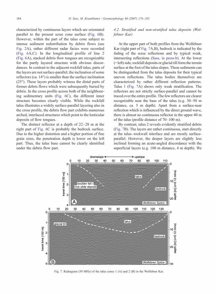
4.2. Stratified and non-stratified talus deposits (Wol-febner Kar)
At the upper part of both profiles from the WolfebnerKar (right part of Fig. 7A,B), bedrock is indicated by thefading of the scree reflections and by typical weak,intersecting reflections (Sass, in press-b). At the lower(=left) side, rockfall deposits or glacial till form the terrainsurface at the foot of the talus slopes. These sediments canbe distinguished from the talus deposits for their typicaluneven reflections. The talus bodies themselves arecharacterized by rather different reflection patterns.Talus 1 (Fig. 7A) shows only weak stratification. Thereflectors are not strictly surface-parallel and cannot betraced over the entire profile. The few reflectors are clearerrecognizable near the base of the talus (e.g. 30–50 mdistance, ca. 5 m depth). Apart from a surface-nearreflection which is influenced by the direct ground wave,there is almost no continuous reflector in the upper 40 mof the talus (profile distance of 70–100 m).
By contrast, talus 2 reveals evidently stratified debris(Fig. 7B). The layers are rather continuous, start directlyat the talus–rockwall interface and are mostly surface-parallel. However, the deeper layers are slightly lessinclined forming an acute-angled discordance with thesuperficial layers (e.g. 100 m distance, 4 m depth). We
s 1 (A) and 2 (B) in the Wolfebner Kar.

185O. Sass, M. Krautblatter / Geomorphology 86 (2007) 176–192
attribute the difference between taluses 1 and 2 mainlyto a higher influence of redistribution processes at talus2, caused by higher amounts of concentrated overlandflow from the less steep and more dissected rockwall (cf.Table 2).
4.3. Examples of deposits subject to debris redistribu-tion processes (Kühtai and Parzinn)
The radargrams in Fig. 8 provide further examples ofreflection patterns which we relate to characteristictypes of layered structures.
– Kühtai “Neunerkogel” (Fig. 8A): The radargram showsapparent stratification in the upslope (=right) part of thetalus body. The talus body is very shallow near therockwall; further downslope, obvious stratification canbe recognized between approximately 60 and 120 mprofile distances. The layers are not strictly surface-parallel and show small-scale discordances. Near thetalus foot (0–60 m) almost no stratification can befound. The bedrock surface is indicated by a distinctreflection at a maximum depth of 10–12 m; the bed-rock itself is characterized by typical bedding structuresslanting diagonally to the left.
Fig. 8. Examples of talus radargrams from the Kühtai area (A: 50 MHz
– According to field evidence and lichenometric results,the upper part of the talus (right half ) is covered withfiner-grained material with some indication of fluvialredistribution. Small clasts are obviously washeddown from the inclined rock face leading to small-scale debris flow structures on the upper part of thetalus. These structures can be clearly recognized in theradargram. By contrast, the lower part (left half ) ischaracterized by larger clasts originating from rockfallwith redistribution by avalanches. No apparentstratification can be found in this part of the radargram.
– Parzinn “cone 1” and “cone 2” (Fig. 8B, C, D): Anobvious stratification can be recognized in the25 MHz radargrams from the Parzinn area which is,however, not persistent across the entire cones (notethat the resolution is much poorer in the 25 MHzprofiles). In the cross profiles, the layers are bent andnot surface-parallel (see Fig. 8C as an example). Thelayered structures are even clearer in the 50 MHzsection at a part of cone 2 (Fig. 8D). The rest of the50 MHz profile at cone 2 was unfortunately not pro-perly recorded due to an antenna malfunction. How-ever, the short profile shows apparent small-scalediscordances between the debris layers (e.g. between5 and 15 m depth). No evidence for large-scale debris
) and the Parzinn area (B, C: 25 MHz; D: 50 MHz). 1 tick=10 m.
186 O. Sass, M. Krautblatter / Geomorphology 86 (2007) 176–192
flows is found on the very steep and loose talussurface; thus, we attribute the observed structures tosurficial redistribution processes like small-scaledebris flows, dry grain flows, frost-coated flows orsolifluction (see the discussion chapter for details).
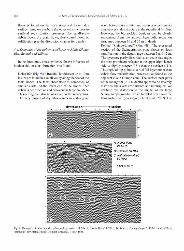
4.4. Examples of the influence of large rockfalls (HoherIfen, Reintal and Kühtai)
In the three study areas, evidence for the influence ofboulder fall on talus formation was found.
– Hoher Ifen (Fig. 9A): Rockfall boulders of up to 10 min size are found in a small valley along the foot of thetalus slopes. The talus sheet itself is composed ofsmaller clasts. At the lower end of the slopes finerdebris is deposited on and between the large boulders.This setting can also be observed in the radargrams.The very loose and dry talus results in a strong air
Fig. 9. Examples of talus deposits influenced by major rockfalls. A: Hohe“Hinterkar” (50 MHz), circles: irregular structures. 1 tick=10 m.
wave between transmitter and receiver which masksalmost every talus structure in the superficial 5–10 m.However, the big rockfall boulders can be clearlyrecognized from the arched, hyperbolic reflectionstructures between 10 and 25 m in depth.
– Reintal “Steingerümpel” (Fig. 9B): The presentedsection of the Steingerümpel cone shows obviousstratification in the depth range between 5 and 12 m.The layers are partly discordant at an acute bias angle;the most prominent reflector at the upper (right hand)side is slightly steeper (33°) than the surface (31°).The angle of dip points to a rockfall layer rather thandebris flow redistribution processes, as found at theadjacent Blaue Gumpe cone. The surface-near partsof the radargram (0–3 m depth) appear to be severelydistorted; the layers are cluttered and interrupted. Weattribute this distortion to the impact of the largeSteingerümpel rockfall which tumbled down over thetalus surface 500 years ago (Schrott et al., 2002). The
r Ifen (25 MHz); B: Reintal, “Steingerümpel” (50 MHz); C: Kühtai,
187O. Sass, M. Krautblatter / Geomorphology 86 (2007) 176–192
impact of the rockfall boulders partly destroyed thelayered structures. Given sufficient time before the nextmajor event, a new rockfall layer might develop on topof the distorted zone.
– Kühtai “Hinterkar” (Fig. 9C). The thick talus bodyshows clear but frequently interrupted debris layers.Between the almost surface-parallel reflectors, irreg-ular, hook-like structures appear (circles in Fig. 9C).Considering the double-peak grain-size distributionfound at the talus surface, we assume that the linearreflectors are due to finer-grained layers which indi-cate moderate activity of small-scale rockfalls. Theirregular areas are in all probability due to boulder-size material originating from medium-size rockfalls.These episodic rockfall events distort and partiallydestroy the stratification.
5. Discussion
All talus slopes we investigated (not only the examplespresented) turned out to be stratified to a certain degree.The GPR results permit the clear distinction of charac-teristic stratification features which are of central im-portance for the recognition of stratification processesinvolved. According to the results, the stratificationobserved in the talus radargrams differs in thickness,dip angle, distinctness and continuity of the layeredunits. Thus, different models of scree slope develop-ment apply.
5.1. Validity of previous models of stratified debrisformation
Numerous models have been developed to describethe generation of strata of lenticular appearance in screedeposits. These models involve creep in Alpine soli-fluction lobes (Bertran et al., 1993), dry grain flows(Lowe, 1976), frost-coated flows (Hétu et al., 1994),debris flows and hyper-concentrated flows (Van Steijn,1988; Bertran and Texier, 1994; Blair, 1999) as well asvegetational binding (Bertran and Texier, 1999). Centi-metre-thick layers generated by supranival debris slidingand niveo-aeolian transport (Hétu and Vandelac, 1989;Hétu, 1991, 1995) are too thin to be identified in theapplied GPR resolution, and thus these processes shouldbe excluded from our interpretation of GPR imagery.
The occurrence of Alpine solifluction lobes is deter-mined by altitudinal and material restrictions such as thepresence of finer-grained sediment. Solifluction sheetsand lobes resulted from periglacial processes in matrix-rich material lead to a two-fold stratification: a surficiallayer of coarse clasts on a matrix-rich heterogeneous
layer, and the latter rests on a former layer of coarse clast.In Alpine conditions layer dimensions are likely to reacha few tens of centimetres in thickness and a fewmetres inwidth and length (Francou, 1990; Bertran et al., 1993;Van Steijn et al., 1995). Thus, this type of layering is alsotoo fine to be responsible for the observed GPR ref-lection patterns. Furthermore, solifluction processes arerather unlikely because of the very dry, matrix-poorcharacter of the scree slopes investigated.
Only one of the scree slopes investigated (BlaueGumpe line 2, Fig. 6) shows evidence of intense sedi-ment redistribution by debris flows. The radar reflectionpatterns in this part of the Reintal slope are clearlydifferent from the adjacent rockfall talus as well as allother talus slopes investigated. Moreover, the dip angleof the sediment bodies (approximately 14°) indicatestheir debris flow origin (Fischer, 1965). Thus, intensivedebris flow processes which cut deeply into the uppertalus and led to large-scale sediment redistribution can beidentified from the radargram. Accordingly, large-scaledebris flows as an agent of talus formation can beexcluded for most of the other sites investigated.
However, smaller-scale, surficial debris flows werefrequently observed in the study areas. These processesmay be initiated by overland flow from furrows in therockwall (Fryxell and Horberg, 1943), heavy rainfall orsnowmelt leading to over-saturation of the debris(Wilkinson and Schmid, 2003), over-steepening of thetalus slope (dry grain flows, Lowe, 1976), ormay occur asfrost-coated grain flows (Hétu et al., 1994). The layeringeffect is probably due to kinematic sieving (Carniel andScheidegger, 1974) and the vertical increase in flowvelocity. We summarize these processes under the term“surficial debris flows” no matter whether these are trig-gered by over-steepening, heavy rainfall or frost coating.These processes are likely to cause more or less surface-parallel, slightly discordant layers (see Wilkinson andSchmid, 2003, Fig. 3) which, in most instances, do notextend across the entire talus. Thus, this explanationprobably applies to the Parzinn (Fig. 8B–D) and theWolfebner Kar (Fig. 7B). Continuous, often undulatingbeds with a clear stratification which are preferably de-veloped in the lower scree slope sections are traced to thefinal deposition zone of dry grain flows and frost-coatedclast flows, perhaps sometimes modified by nival trans-port or supranival debris sliding. The reflection patterns inthe Wolfebner Kar 1 talus (layers predominantly devel-oped in the lower talus section; Fig. 7A) may point to thistype of redistribution process, while the upper part of thetalus is apparently built up by continuous rockfall withonly moderate post-depositional redistribution. By con-trast, at the Neunerkogel site (Fig. 8A), the stratification is
188 O. Sass, M. Krautblatter / Geomorphology 86 (2007) 176–192
restricted to the upper section of the talus adjacent to therockwall. Thus, we assume that overland flow and down-wash from the inclined rock face is responsible for thelayered structure in this position. Furthermore, pre-depo-sitional sorting processes may contribute to the layering,as discussed below.
5.2. A model of talus slope development
The processes discussed above account for many ofthe stratification features found in the radargrams. It canbe presumed that all these models explain the stratifica-tion as a result of post-depositional processes such asredistribution and sorting. However, while these modelsprovide numerous possible explanations for layeredstructures in a spatially confined part of the scree slope,few convincing ideas for the development of large-scalecontinuous beds with a clear stratification have so farbeen established. The exposure and the radargrams of theBlaue Gumpe talus (Figs. 4–6) have shown that the screelayers are all orientated parallel to the present screesurface, continuous across almost the entire talus, andbranded by a contrast in the grain size distribution of thedebris. None of the models presented so far can accountfor this type of layering.
Therefore, we have developed a new model for thegeneration of continuous strata in scree slopes formountain areas in warm temperate conditions. At theBlaue Gumpe talus the scree layers are absolutelysurface-parallel with a maximum dip angle of 26°. Weunderstand that the present angle of the scree surface,which is lower than the maximum angle of reposeaccording to the Statham–Kirkby-Model (Statham,1976), is an expression of active rockfall deposition.The resemblance of the layers' orientation, internalstructure, dip direction and especially the dip angle topresent active rockfall deposits provides strong evi-dence for their rockfall origin. This means that thelayers have not been formed due to post-depositionalreorganisation of scree but due to temporal fluctuationsin the rockfall grain size input from the rock face. High-magnitude rockfalls can be excluded as a source of thelayers as no impact structures are apparent in the fine-grained layers underlying the coarse debris. Further-more, no evidence of distortion of the layers can befound in the radargrams.
A four-year quantitative rockfall study that has beenconducted in Reintal has offered an explanation fortemporal fluctuations in rockfall clast size (Krautblatter,2003; Krautblatter et al., in press). During periods ofintense freeze–thaw activity, predominantly coarse-grained (N2 cm) particles with a weight proportion of
80% were deposited. This is due to (i) a preferredloosening of larger particles by frost action and (ii) thefact that larger particles are less prone to stop at inter-mediate storage areas (Rapp, 1960; Bones, 1973;Statham, 1976; Bozzolo, 1987; Erismann and Abele,2001). While this coarse-grained deposition is confinedto a few days of wet freeze–thaw conditions in springand autumn, the rockfall deposition during the other daysis dominated by the accumulation of fine-grained debrisduring extreme summer precipitation. During the fouryears of rockfall measurements at this site, more than90% of rockfall was deposited by “gross secondaryrockfall events” (Krautblatter and Moser, 2005; Kraut-blatter et al., 2006), which were defined as a short-termmass deposition of fine-grained rockfall material sup-plied from intermediate storage areas on the rockwalldue to fluvial processes and debris-saturated flows. Theshort-term intensity of rockfall deposition exceeds thedeposition during dry periods without frost by a factor ofat least 104 (Krautblatter et al., 2006). The material ofgross secondary rockfall events resembles that ofintermediate storages with a 14–50% weight proportionof fines (b2 cm). Thus, we assume that fine-grainedlayers indicate periods of preferred depletion of inter-mediate storages by intense rainstorm activity. In con-clusion, the coarse-grained layers of Fig. 4 resemble thegrain size distribution of predominantly frost-inducedrockfall with selective filling of intermediate storage.
In this model two external climatic factors influence thegrain size of small-scale rockfall supply: magnitude andfrequency of intense summer rainstorms and the abun-dance of intense (wet) freeze–thaw conditions. Accordingto McCarroll et al. (1998, 2001), the intensity of frost-induced rockfall activity in Norway increased up to seventimes in the Little Ice Age, because of more frequenteffective freeze–thaw conditions. The activity of frost-weathering is directly linked to the number of effectivefrost cycles (Matsuoka, 1990; Sass, 1998) whose fre-quency in the study areas declined since the Little Ice Age(Hauer, 1950). This argument can easily be transferred tothe extraordinarily climate-sensitive Reintal, whose gla-ciers show a pronounced response to the warming after theLittle Ice Age (Hera, 1997). In contrast, the frequency ofintense rainstorms has evidently more than doubled sincethe end of the Little IceAge (DWD, 2001).We expect suchclimatic fluctuations lead to an oscillation between twosteady states. Cooler periods such as the Little IceAgewitha high frost activity and low rainstorm frequency providerockfall inputs for coarse-grained scree layers. Warmperiods with little frost action and enhanced rainstormactivity deplete intermediate storages and produce fine-grained scree layers. This inference is supported by the
189O. Sass, M. Krautblatter / Geomorphology 86 (2007) 176–192
estimation that the transition between the present upper-most fine-grained layer and the underlying coarse-grainedlayer corresponds to 1870–1900 on the basis of presentrockfall deposition rates. Although no absolute dating isavailable, these deposition rates were derived indepen-dently in four separate rockfall collectors at the specific sitewith a measurement of more than 20 t of rockfall depositsfrom 1999 to 2003 and were adjusted to average 20thcentury environmental conditions (Krautblatter et al., inpress). They are, thus, believed to be highly representative.
The model outlined above does not explain all typesof debris stratification found at scree slopes. It onlyapplies to slopes with large rockwalls with prominentintermediate storages (cf. Table 2) which can keep fine-grained rockfall debris for centuries, in a climaticallysensitive setting. A typical example of this is the BlaueGumpe site having the exceptional thickness and con-tinuity of the scree layer deposits supplied from the largerockwall. The formation of equally continuous but thin-ner layers may reflect the same mechanism but lowerdebris availability. Thus, the outlined model may alsoapply to the Wolfebner Kar 2 talus and partly to theKühtai and Parzinn cones.
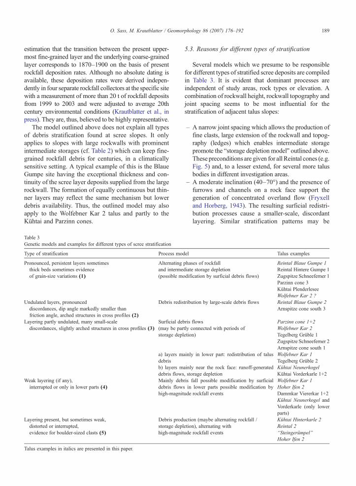
Table 3Genetic models and examples for different types of scree stratification
Type of stratification Process mod
Pronounced, persistent layers sometimesthick beds sometimes evidenceof grain-size variations (1)
Alternatingand interme(possible mo
Undulated layers, pronounceddiscordances, dip angle markedly smaller thanfriction angle, arched structures in cross profiles (2)
Debris redis
Layering partly undulated, many small-scalediscordances, slightly arched structures in cross profiles (3)
Surficial deb(may be parstorage depl
a) layers mdebrisb) layers mdebris flows
Weak layering (if any),interrupted or only in lower parts (4)
Mainly debdebris flowhigh-magnit
Layering present, but sometimes weak,distorted or interrupted,evidence for boulder-sized clasts (5)
Debris prodstorage deplhigh-magnit
Talus examples in italics are presented in this paper.
5.3. Reasons for different types of stratification
Several models which we presume to be responsiblefor different types of stratified scree deposits are compiledin Table 3. It is evident that dominant processes areindependent of study areas, rock types or elevation. Acombination of rockwall height, rockwall topography andjoint spacing seems to be most influential for thestratification of adjacent talus slopes:
– A narrow joint spacing which allows the production offine clasts, large extension of the rockwall and topog-raphy (ledges) which enables intermediate storagepromote the “storage depletion model” outlined above.These preconditions are given for all Reintal cones (e.g.Fig. 5) and, to a lesser extend, for several more talusbodies in different investigation areas.
– A moderate inclination (40–70°) and the presence offurrows and channels on a rock face support thegeneration of concentrated overland flow (Fryxelland Horberg, 1943). The resulting surficial redistri-bution processes cause a smaller-scale, discordantlayering. Similar stratification patterns may be
el Talus examples
phases of rockfalldiate storage depletiondification by surficial debris flows)
Reintal Blaue Gumpe 1Reintal Hintere Gumpe 1Zugspitze Schneeferner 1Parzinn cone 3Kühtai PlenderleseeWolfebner Kar 2 ?
tribution by large-scale debris flows Reintal Blaue Gumpe 2Arnspitze cone south 3
ris flowstly connected with periods ofetion)
Parzinn cone 1+2Wolfebner Kar 2Tegelberg Grüble 1Zugspitze Schneeferner 2Arnspitze cone south 1
ainly in lower part: redistribution of talus Wolfebner Kar 1Tegelberg Grüble 2
ainly near the rock face: runoff-generated, storage depletion
Kühtai NeunerkogelKühtai Vorderkarle 1+2
ris fall possible modification by surficials in lower parts possible modification byude rockfall events
Wolfebner Kar 1Hoher Ifen 2Dammkar Viererkar 1+2Kühtai Neunerkogel andVorderkarle (only lowerparts)
uction (maybe alternating rockfall /etion), alternating withude rockfall events
Kühtai Hinterkarle 2Reintal 2“Steingerümpel”Hoher Ifen 2
190 O. Sass, M. Krautblatter / Geomorphology 86 (2007) 176–192
caused by dry grain flows or frost-coated flows.However, the comparison between the two Wolfeb-ner Kar talus slopes (Fig. 7) suggests that overlandflow from an inclined, dissected rockwall promotesthe generation of this type of layering. As pointedout before, the two slopes differ mainly in topo-graphical characteristics of the rockwalls abovethem. While talus 1 is of the un-stratified “debrisfall” type, the rockwall above the neighbouring talus2 is slightly dissected by rockfall couloirs. Thus, therelated talus is obviously stratified due to redistri-butional processes with some intermediate storagedepletion.
– If the rockwall is very steep and compact, debris fall isthe main agent of talus formation, and layering is onlypresent near the talus foot due to sediment redistri-bution processes (e.g. Wolfebner Kar 1). The Kühtaitaluses (Neunerkogel and Vorderkarle) have a hybridform with a coarse, un-stratified rockfall talus in thedownslope parts and surficial debris flow modifica-tion near the rockwalls.
– Sediment redistribution by major debris flows is res-tricted to certain positions with large furrows cuttingdeep into the talus body, which concentrate overlandflow from a large catchment area (e.g. Blaue Gumpe,Fig. 6).
– The alternation of continuous debris falls with epi-sodic rockfall events provides a further explanation oflayered structures which can be recognized fromGPRimages. However, due to the impact energy and kine-matics of a large fallen rock, no continuous layer canbe expected. At the Hinterkar talus (Kühtai area), therockwalls are poor in intermediate storage due to thelarge grains produced. However, the grain size dis-tribution of the scree slopes and lichen measurements(Sass, unpublished) point to periods of enhancedboulder-sized rockfall alternating with phases of sed-iment redistribution, finer-grained rockfall and soildevelopment.
6. Conclusions
GPR turned out to be a powerful tool for talus slopeinvestigation, providing new insights into sedimentarchives which have not been accessible to date. Theresults of the radar measurements in the Eastern Euro-pean Alps show that all the talus bodies investigated arestratified to a certain degree. However, a number of quitedifferent processes are probably responsible for thespecific type of stratification. Among the numerous post-depositional sorting processes suggested in the literature,we assume that small-scale, surficial debris flows pro-
vide the best explanation for the layering observed inmany of the talus bodies. To explain the presenceof surface-parallel, persistent layers at the Blaue Gumpesite, we developed a novel model of talus slope devel-opment which is driven by climatic fluctuations. Thedelivery of coarse debris prevails in periods of enhancedfreeze–thaw activity like the Little Ice Age, whereaswarmer periods like today are characterized by the dep-letion of finer-grained intermediate stores connectedwith summer rainstorms.
The determining factors for the type of layering foundat a specific talus are rockwall characteristics like height,steepness and dissection of the rock face. Narrow jointspacing (causing small clasts), moderate inclination,dissection and intermediate debris storage within therockwall promote a pronounced layering, while screeslopes adjacent to steep and uniform rockwalls tend toshow much lesser stratification.
Acknowledgements
We are grateful to the numerous undergraduate assis-tants who helped in handling the radar antennas on thesteep slopes. Special thanks to Profs. M. Moser andD. Keller for their continued support. The GPR mea-surements were carried out in the framework of theproject “Loose Sediments in Alpine Regions”, while therockfall measurements and observations in the Reintalwere performed as part of the research programmeSEDAG (“Sediment Cascades in Alpine Geosystems”),both founded by the German Research Foundation.
References
Berthling, I., Etzelmüller, B., Isaksen, K., Sollid, J.L., 2000. Rockglaciers on Prins Karls Forland. II: GPR soundings and thedevelopment of internal structures. Permafrost and PeriglacialProcesses 11, 357–369.
Bertran, P., Texier, J.-P., 1994. Structures sédimentaires d`un cône deflots de débris. Permafrost and Periglacial Processes 5, 155–170.
Bertran, P., Texier, J.-P., 1999. Sedimentation processes and facies on asemi-vegetated talus, Lousteau, Southwestern France. EarthSurface Processes and Landforms 24, 177–187.
Bertran, P., Francou, B., Pech, P., 1993. Stratogenèse associé à ladynamique des coulées à front pierreux en milieu alpin, La MorticeAlpes Méridionales, France. Géographie Physique et Quaternaire47, 93–100.
Bilkra, L.H., Nemec, W., 1998. Postglacial colluvium in westernNorway: depositional processes, facies and paleoclimatic record.Sedimentology 45, 909–959.
Blair, T.C., 1999. Cause of dominance by sheetflood vs. debris-flowprocesses on two adjoining alluvial fans Death Valley, California.Sedimentology 46, 1015–1028.
Bones, J.G., 1973. Process and sediment size arrangement on higharctic talus slopes, South West Devon Island, N.W.T. Arctic andAlpine Research 5, 29–40.
191O. Sass, M. Krautblatter / Geomorphology 86 (2007) 176–192
Bozzolo, D., 1987. Ein mathematisches Modell zur Beschreibung derDynamik von Steinschlag. ETH, Zürich.
Carniel, P., Scheidegger, A.E., 1974. Morphometry of an Alpine screeslope. Revista Italiana di Geografica 23, 95–100.
Curry, A.M., Black, R., 2002. Structure, sedimentology and evolutionof rockfall talus in Mynydd Du, South Wales. Proceedings of theGeologists' Association 114, 49–64.
DWD, 2001. Der langjährige Niederschlagstrend am Hohenpeißen-berg: Die Bedeutung von Extremwerten. Global AtmosphereWatch Brief des Deutschen Wetterdienstes, vol. 5.
Erismann, T.H., Abele, G., 2001. Dynamics of Rockslides andRockfalls. Springer, Heidelberg.
Fischer, K., 1965. Murkegel, Schwemmkegel und Kegelsimse in denAlpentälern. Mitteilungen der Geographischen GesellschaftMünchen 50, 127–159.
Francou, B., 1990. Stratification processes in slope deposits in highsubequatorial mountains. Permafrost and Periglacial Processes 1,249–263.
Fryxell, F.M., Horberg, L., 1943. Alpine mudflows in Grand TetonNational Park, Wyoming. Bulletin of the Geological Society ofAmerica 54, 457–472.
Garcia-Ruiz, J.M., Valero-Garcés, B., González-Sampériz, P., Lorente,A., Marti-Bono, C., 2001. Stratified scree in the Central SpanishPyrenees: paleoenvironmental implications. Permafrost and Peri-glacial Processes 12, 233–242.
Gengnian, L., Zhijiu, C., Daokai, G., Yongqiu, W., 1999. The stratifiedslope deposits at Kunlunshan Pass, Tibet Plateau, China.Permafrost and Periglacial Processes 10, 369–375.
Guillien, Y., 1951. Les grèzes litées de Charente. Revue Géographiquedes Pyrénées et du Sud-Ouest 22, 153–162.
Harris, S.A., Prick, A., 2000. Conditions of formation of stratifiedscrees, Slims River Valley, Yukon Territory: a possible analoguewith some deposits from Belgium. Earth Surface Processes andLandforms 25, 463–481.
Hauer, H., 1950. Klima und Wetter der Zugspitze. Berichte desdeutschen Wetterdienstes in der US Zone, vol. 16.
Hera, U., 1997. Gletscherschwankungen in den Nördlichen Kalkalpenseit dem 19. Jh. Münchner Geogr. Abh. Reihe B.
Hétu, B., 1991. Eboulis stratifiés actifs près de Manche-d`Epée,Gaspésie (Québec, Canada). Zeitschrift für Geomorphologie N.F.35, 439–461.
Hétu, B., 1995. Le Litage des Éboulis Stratifiés Cryonivaux enGaspésie (Québec, Canada): Rôle de la Sedimentation Nivéo-Éolienne et des Transits Supraniveaux. Permafrost and PeriglacialProcesses 6, 147–171.
Hétu, B., Gray, J.T., 2000. Effects of environmental change on screeslope development throughout the postglacial period in the Chic-Choc Mountains in northern Gaspé Peninsula, Québec. Geomor-phology 32, 335–355.
Hétu, B., Vandelac, P., 1989. La dynamique des éboulis schisteux aucours de l`hiver, Gaspésie septentrionale, Québec. GéographiePhysique et Quaternaire 43, 389–406.
Hétu, B., Van Steijn, H., Vandelac, P., 1994. Les coulées de pierresglacées: un nouveau type de coulées de pierraille sur les talusd`éboulis. Géographie Physique et Quaternaire 48, 3–22.
Hinchcliffe, S., 1999. Timing and significance of talus slope reworking,Trotternish, Skye, northwest Scotland. Holocene 9, 483–494.
Hutchinson, J.N., 1998. A small-scale field check on the Fisher–Lehmann and Bakker–Le Heux cliff degradation models. EarthSurface Processes and Landforms 23, 913–926.
Krautblatter, M., 2003. The Impact of Rainfall Intensity andOther External Factors on Primary and Secondary Rockfall
(Reintal, Bavarian Alps). University of Erlangen-Nuremberg,Germany.
Krautblatter, M., Moser, M., 2005. The implications of a four-yearquantitative rockfall measurement for hazard assessment, riskmitigation and the design of protection measures. Proceedingsof the 15th Conference on Engineering Geology, Erlangen,pp. 67–72.
Krautblatter, M., Moser, M., Dikau, R., 2006. Nonlinear response ofsmall-scale rockfall activity to rainfall intensity: the importance ofgross secondary rockfall events. Geophysical Research AbstractsEGU06-A-10895.
Krautblatter, M., Moser, M., Schrott, L., Wolf, J., in press. A study onsediment yield and geomorphic work comprising all rockfallmagnitudes in an Alpine Catchment (Reintal, German Alps).Geomorphology.
Lønne, I., Lauritsen, T., 1996. The architecture of a modern push-moraine at Svalbard as inferred from ground-penetrating radarmeasurements. Arctic and Alpine Research 4, 488–495.
Lowe, D.R., 1976. Grain flow and grain-flow deposits. Journal ofSedimentary Petrology 46, 188–199.
Matsuoka, N., 1990. The rate of bedrock weathering by frost action:field measurements and a predictive model. Earth SurfaceProcesses 15, 73–90.
McCarroll, D., Shakesby, R.A., Matthews, J.A., 1998. Spatial andtemporal pattern of Late Holocene rockfall activity on a Norwegiantalus slope: a lichenometric and simulation-modelling approach.Arctic and Alpine Research 30, 51–60.
McCarroll, D., Shakesby, R.A., Matthews, J.A., 2001. Enhancedrockfall activity during the Little Ice Age: further lichenometricevidence from a Norwegian talus. Permafrost and PeriglacialProcesses 12, 157–164.
Otto, J.C., Sass, O., 2006. Comparing geophysical methods for talusslope investigations in the Turtmann valley (Swiss Alps).Geomorphology 76, 257–272.
Rapp, A., 1960. Recent developments in the mountain slopes inKärkevagge and surroundings, Northern Scandinavia. GeografiskaAnnaler 42, 1–158.
Sass, O., 1998. Die Steuerung von Steinschlagmenge durch Mikrok-lima, Gesteinsfeuchte und Gesteinseigenschaften im westlichenKarwendelgebirge. Münchener Geographische Abhandlungen.Reihe B 29.
Sass, O., 2005. Spatial patterns of rockfall intensity in the northernAlps. Zeitschrift für Geomorphologie N.F. 138, 51–65.
Sass, O., 2006. Determination of the internal structure of alpine talusdeposits by aid of geophysical measurements (Lechtaler Alps,Austria). Geomorphology 80, 45–58.
Sass, O., in press-a. Thickness and structure of a relict talus in theAmmergau Alps, Germany. Zeitschrift für Geomorphologie N.F.
Sass, O., in press-b. Bedrock detection and talus thickness assessmentin the European Alps using geophysical methods. Journal ofApplied Geophysics.
Schrott, L., Niederheide, A., Hankammer, M., Hufschmidt, G., Dikau,R., 2002. Sediment storage in a mountain catchment: geomorphiccoupling and temporal variability (Reintal, Bavarian AlpsGermany). Z. Geomorph. N. F. Suppl.-Bd. 127, 175–196.
Statham, I., 1976. A scree slope rockfall model. Earth SurfaceProcesses 1, 43–62.
Van Steijn, H., 1988. Debris flows involved in the development ofPleistocene stratified scree deposits. Zeitschrift für Geomorpholo-gie N.F. Supplementband 71, 45–58.
Van Steijn, H., 1997. Rain-generated overland flow as a factor in thedevelopment of some stratified scree deposits: a case study from

192 O. Sass, M. Krautblatter / Geomorphology 86 (2007) 176–192
the Pays du Buëch (Préalpes France). Géographie Physique etQuaternaire 51, 3–15.
Van Steijn, H., Bertran, P., Francou, B., Hétu, B., Texier, J.-P., 1995.Models for the genetic and environmental interpretation ofstratified scree slope deposits: review. Permafrost and PeriglacialProcesses 6, 125–146.
Whalley, W.B., 1984. Rockfalls. In: Brunsden, D., Prior, D.B. (Eds.),Slope Instability. Wiley and Sons, London, pp. 217–256.
Wilkinson, F.D., Schmid, G.L., 2003. Debris flows in Glacier NationalPark, Montana: geomorphology and hazards. Geomorphology 55,317–328.