
DCP No 36 - Engineering Guidelines for Subdivision and ... · PDF file1 1. INTRODUCTION 1.1...
40
DEVELOPMENT CONTROL PLAN NO 36 ENGINEERING GUIDELINES FOR SUBDIVISION AND DEVELOPMENT December 2001
Transcript of DCP No 36 - Engineering Guidelines for Subdivision and ... · PDF file1 1. INTRODUCTION 1.1...

DEVELOPMENT CONTROL PLAN NO 36
ENGINEERING GUIDELINES FOR SUBDIVISION AND DEVELOPMENT December 2001

TABLE OF CONTENTS 1.0 INTRODUCTION
1.1 Citation 1.2 Commencement 1.3 Scope 1.4 Aims and Objectives 1.5 Relationship to Other Plans
2.0 HOW THIS PLAN WORKS 3.0 THE DEVELOPMENT PROCESS
3.1 Consent Authority/Principle Certifying Authority/Accredited Certifiers 3.2 Planning Controls 3.3 Type of Development 3.4 Applications 3.4.1 Pre Lodgment Meeting
3.4.2 Applications 3.4.3 Determination 3.4.4 Subdivision Construction Certificate 3.4.5 Subdivision Certificate
4.0 COUNCIL REQUIREMENTS 4.1 Subdivision Design - Urban Residential Areas
4.2 Subdivision Design - Rural Residential Areas 4.3 Subdivision Design - Rural Development Areas 4.4 Subdivision Design - Industrial/Commercial Areas 4.5 Subdivision - Natural Hazard Areas 4.6 Provision of Open Space and other Contributions 4.7 Geotechnical Considerations 4.8 Acid Sulfate Soils 4.9 Temporary Road Works 4.9.1 Crown Roads
5.0 SERVICES AND EASEMENTS
5.1 General 5.2 New Roads 5.3 Damage to Access Roads 5.4 Effluent Disposal 5.5 Supervision
6.0 ENGINEERING REQUIREMENTS 6.1 Engineering Plans and Specifications 6.2 Commencement of Works 6.3 Inspections and Testing

6.4 Insurances 6.5 Work-As-Executed Plans 6.5.1 General
6.5.2 Information To be Shown 6.5.3 Information to be Submitted
6.6 Completion of Works and Certification 6.7 Early Release of Allotments - By Application 6.8 Maintenance 6.9 Contributions
1
1. INTRODUCTION 1.1 Citation
This plan may be cited as Development Control Plan No. 36 Engineering Guidelines for Subdivision and Development and Subdivision Code, Kempsey Shire.
1.2 Commencement
The Plan known as Engineering Guidelines for Subdivision and Development and Subdivision Code was adopted by Kempsey Shire Council on the (insert date) This Plan comes into effect (insert date).
1.3 Scope of the Plan and Where it Applies
This Plan applies to all land in the Kempsey Shire local government area where civil work is to be undertaken in conjunction with development consent issued under Kempsey Local Environmental Plan 1987.
1.4 Aims and Objectives
The aim of this development control plan (DCP) is to replace the existing Engineering Guidelines for Subdivision and Development with a Council Code and regional version of Aus-Spec #1 Design and Construction Development Specification series prepared in consultation with the IPWEA Mid North Council’s user group and Council’s Engineering Department. The secondary aim is to provide developers, their agents, consulting Surveyors/Engineers and Civil Contractors with Council’s minimum requirements for the design and construction of all civil works to be undertaken in the Kempsey Shire local government area. In order to achieve these aims the following principle objectives are to form part of this Plan:- � To provide a degree of certainty to developers, their agents, consultant
Surveyors/Engineers and Civil Contractors as to Council’s minimum requirements for design and construction of civil works.
� To encourage more innovative subdivision design, efficient site usage, and
minimize the cost of urban infrastructure and servicing in a manner that maintains equal access to public infrastructure, given the physical limitations of any one site and the provisions of Kempsey Local Environmental Plan 1987 and associated Development Control Plans.
� Minimize Council’s costs associated with maintenance of future public
infrastructure. � To employ ameliorating measures sufficient to reduce the impact of development
on the existing natural and man made environments. � To limit development in the Kempsey Shire that complies with the provisions of
councils’ Flood Plain Management Strategy Policy.

2
1.5 Relationship to Other Plans
This Plan has been prepared in accordance with section 72 of the Environmental Planning and Assessment Act 1979 and Part 3 Division 1 of the Environmental Planning and Assessment Regulation 2000. The following plans and policies may also apply: - DCP No. 1 - Crescent Head road, South East Kempsey. DCP No. 2 - Arakoon Road South West Rocks DCP No. 3 - River Meadows, South Kempsey. DCP No. 4 - Aldavilla, West Kempsey. DCP No. 5 – Fishermans Reach DCP No. 6 – Verges Swamp Road. DCP No. 10 – Provision for Open Space for South West Rocks and district DCP No. 11 – Aboriginal Heritage. DCP No. 12 – Conflicting Land Uses. DCP No. 13 – Manufactured Home Estates and Caravan Parks DCP No. 14 – Greenhill Aboriginal Corporation and Warwick Park Estate. DCP No. 15 – Saleyards Road, Tennessee DCP No. 16 – John Lane Road, West Kempsey. DCP No. 17 – Kemps Access, Collombatti. DCP No. 18 – Kundabung, West of Pacific Highway DCP No. 19 – Crescent head road, near Beranghi Road. DCP No. 20 – Wortley Drive off Beranghi Road DCP No. 21 – Dulconghi Heights near Crescent Head. DCP No. 22 – Local Housing Strategy. DCP No. 23 – Central business District, Kempsey DCP No. 24 – Access and Mobility. DCP No. 25 – Advertising Signs DCP No. 28 – Leasing of Public Areas for Restaurants and Cafes. DCP No. 29 – Bed and Breakfast Accommodation. DCP No. 30 – Acid Sulfate soils DCP No. 31 – Energy Smart Homes. DCP No. 34 – South West Rocks Town Centre DCP No. 35 – Gladstone Conservation Area. DCP No. 30 – Exempt and Complying Development. DCP – Gladstone Village. DCP – Frederickton Village Policy No. 12.8– Issue of Receipts Policy No. 15.4– Damage to Water Meters Policy No. 15.7 – Maintenance of Subdivisions Policy No. 15.8 – Public Gates and Grids Policy No. 22.2 – Plant hire and private Works Policy No. 22.3 – Contribution to Works for Foot-paving Policy No. 22.4 – Contribution to Works for Kerbing and Guttering Policy No. 22.8 – Freedom of Information Policy No. 22.12 – Lease of Council Property and Roads Policy No. 23.1 – Advertising of Development Applications Policy No. 23.11 – Tree Preservation Order Policy No. 23.12 – Parking Code Policy No. 23.6 – Flood Plain Management Strategy Policy No. 25.3 – Access to rural Residential Areas Policy No. 25.4 – Street Naming Policy No. 25.6– Implementation of Water Restrictions Policy No. 25.7– Street Lighting on Public Roads

3
Policy No 20.9 – Disability Access Policy Current Section 94 Contribution Plans Current Section 64 Development Service Plans Kempsey Shire Council Aus- Spec #1 Design Specifications Kempsey Shire Council Aus- Spec #1 Construction Specifications The above list will be updated to include new and amended codes, council policies and development control plans.

4
2.0 HOW THIS PLAN WORKS The Plan has the following components; - (a) The Development process
This section describes the development process from lodgment of the Local Development Application for subdivision through to the issue of the Subdivision Certificate and the relevant Acts that control the development process in urban and rural zones of the Kempsey Shire.
(b) Aus-Spec#1 - Design
This section contains the minimum design requirement for the following works; - � Geometric road Design for Rural and Urban areas � Pavement Design � Structures/ Bridge design � Subsurface Drainage Design � Stormwater Drainage Design � Site Re-grading � Erosion Control and Stormwater Management � Waterfront development � Cycle-way and Pathway Design � Bushfire protection � Water Reticulation � Sewerage System � Landscaping
There may be a circumstance that warrants the departure from the minimum requirements as set down in this section can be justified. A written submission including supporting documents would need to be lodged with council demonstrating compliance with the aims and objectives of this Plan.
(c) Aus-Spec#1 – Construction
This section contains the minimum construction requirements for the following works; - � General � Control of Traffic � Control of Erosion and Sedimentation � Clearing and grubbing � Earthworks � Stormwater Drainage – General � Pipe Drainage � Pre-cast Box Culverts � Drainage Structures � Open Drains including kerb and gutter � Subsurface Drainage – General � Subsoil and foundation Drains � Pavement Drains � Drainage Mats � Stabilization � Flexible pavements � Spayed Bituminous Surfacing � Asphaltic Concrete � Mass Concrete Sub Base � Plain or reinforced Concrete Base

5
� Segmental Paving � Bituminous Micro Surfacing � Pavement Markings � Signposting � Guide Posts � Guard Fence � Boundary Fencing � Minor Concrete Works � Landscaping � Water Reticulation � Sewerage System � Bush Fire Protection
(d) Completion and Maintenance
Outlines procedures for matters such as Works as Executed plans, Linen Plans, Instruments, Engineering bonds, issue of Subdivision Certificates and Maintenance of civil works.
This Plan provides a single document that incorporates a Subdivision Code and Design and Construction Development specifications for the guidance of developers, their agents, Surveyors, Engineers and Civil Contractors.

6
3.0 THE DEVELOPMENT PROCESS Figure 1 shown below outlines how the development process operates: -
D eve loper(S ubdiv ider)
S ta teG overnm ent'sR equ irem entsC ounc il
R equ irem ents and
P rocedures
D eve loperC onsu lts w ith
C ounc il
D evelopm ent A pplica tion
C om m unity C onsulta tion
D evelopm ent A ssessm ent
R efe rra l to P ublic A uthorities if A ppropria te (eg R T A )
S ubdiv is ion A pproval
E ngineer D es ign A pprova l
C ouncil A pplies
S pec ifica tionR equirem ents S ubdiv ider
R econsiders P roposa l
C onstruc tion of D eve lopm ent and R e lease of D evelopm ent
C ounc il as Q uality A ud ito r A rrangem ents w ith U tilitiy
A uthorities
S A LE O F LA N D
FLO W DIA G R AM - O VERA LL PR O C ESS
N o
Y es

7
3.1 Consent Authority/Principle Certifying Authority and Accredited
Certifiers
Kempsey Shire Council is the consent authority for the issue of subdivision approvals as defined in the Environmental Planning and Assessment Act 1979. The Engineering Planning and Assessment Act 1979 controls the appointment of the Principal Certifying Authority.
3.2 Planning Controls
Table 1 shown below contains planning controls, which are contained in Councils Kempsey, Local Development Plan 1987 and the Flood Plain Management Strategy Policy: - Development Standard Land-use Zone Minimum
Lot Area Reticulated Water Supply
Sewerage System
Flooding Other
Urban 2(a);2(b1), 2(v)
500 m2 To each lot To each lot 500m2 Outside limit 1 in 100year flood
Urban 2(b2),2(c) 800m2 To each lot To each lot 500m2 Outside limit 1 in 100year flood
Urban 3(a), 3(b), Not specified
To each lot To each lot Clause 6.1.2 6.2.1 & 6.2.5 of Flood Strategy
Urban 3(c) Not specified
To each lot To each lot Clause 6.1.2 of Flood Strategy
Urban 4(a),4(b) light Industrial
Not specified
To each lot To each lot Each site to be flood free
Rural 1(c), 1(g) 1 Ha [1(c)] 4 & 8 Ha [1(g)]
To each lot AS 1547-2000 onsite disposal
1,000m2 Outside limit 1 in 100year flood
Rural 1(c) Arakoon 1ha Not Required AS 1547 – 2000 onsite disposal
1,000m2 Outside limit 1 in 100year flood
Rural 1(a1),1(a3),1(a3),1(d),1(e), 7(a),7(d),7(f1), 7(f2), 7(h).
40 Ha Not Required Not required Clause 6.26 of Flood Strategy
Rural 1(a1),1(a3), 40Ha Not Required Not Required Clause 6.26 of Flood Strategy
Minimum frontage to main or arterial road of 400 metres.
Rural 1(a1),1(a3), Lot less than 40 Ha
Not Required Not Required Clause 6.26 of Flood
Purpose other than dwelling or agriculture
8
Table 1 does not contain details of other planning instruments such as State Environmental Planning Policies, Regional Environmental Plans and or related Acts that affect development in the Kempsey Shire local government area. Therefore it is very important that any applicant arrange to meet with council before submitting an application to obtain information as to how these state policies, plans and Acts may affect the development proposal. 3.3 Types of Development There are three broad types of development as follows: - (a) Development that does not require consent.
This category generally applies to developments where Part 5 of the Environmental Planning and Assessment Act 1979 is applicable and or where the development is defined as exempt pursuant to the provisions contained in Council’s Development control Plan 30.
(b) Development that requires consent
This type of development category deals with either Local Development or State Significant Development and is categorized as either of the following classes pursuant to the provisions of Part 4 of the Environmental Planning and Assessment Act 1979: - � Complying Development � Integrated Development � Designated Development � Advertised Development
There are four forms of subdivision as shown below: (i) Land (ii) Dual Occupancy (iii) Community Title; and (iv) Cluster Development
(c) Prohibited Development Table 2 below summarizes the development activities permitted in respect to subdivision contained in Councils Development Control Plan No. 30, Exempt and Complying Development in Kempsey Shire and reference to integrated development: - EXEMPT AND COMPLYING DEVELOPMENT
1. EXEMPT DEVELOPMENT Subdivision
� Consolidation of existing allotments � Creation of a Public reserve by or on
behalf of public authority � Rectifies an encroachment of a
building so as to comply with the deemed to satisfy provisions of the Building Code of Australia and is not contrary to any other requirements of KLEP 1987
� Widening of a Public Road by or on behalf of a public authority.
� In conjunction with an approved development
Complying Development �Each existing allotment is to be above

9
� Boundary adjustment not creating any additional allotments
the minimum allotment size applying to the zone
� All of each existing allotment is within the same zone.
� Each proposed allotment is above the minimum allotment size applying to the zone
� The area of each allotment is not changed by more than 5%
� No water sewerage, or stormwater infrastructure will be required to be relocated.
� Both resultant allotments have dedicated public road access.
� Will not alter the setbacks to any existing building, so as to result in non-compliance with the deemed to satisfy provisions of the Building Code of Australia.
� Does not relate to land defined as ‘Existing Holding” under clause 17 of KLEP 1987.
� All public services are contained within the appropriate easements in accordance with Councils Engineering Guidelines for Subdivision and Development.
� Subdivision pursuant to Clause 16A of Kempsey Local Environmental Plan 1987
� A Building Certificate(s) has been obtained in respect to all buildings within the subdivision
INTEGRATED DEVELOPMENT � Integrated development is development (not being complying development) that, in order for it to be carried out, requires development consent and one or more of the approvals contained in the schedule at Section 91 of the Environmental Planning and Assessment Act 1979
� In the case of a development application that indicates on its face that such an approval is required, the application must be forwarded to the relevant approval body within 2 days after the application is lodged. Section 66(2) of the regulations.
� Appendix 2 contains a copy of the schedule contained in Section 91 of the EP&A Act 1979.
3.4 Applications 3.4.1 Before lodging any application proposal to subdivide land in the Kempsey Shire local
government area it is recommended that the applicant approach council to arrange for a
10
pre lodgment meeting. The main aim of this consultation is to make the applicant aware of the following: -
� Legislative requirements both Local and State � Application Fees and Charges applicable � Whether changes to the sketch plan are required prior to lodging it in final form with
the application � What Assessments are required to be lodged with the application for subdivision. � Whether Public Utility main extensions to serve each lot in the proposal are
required and likely extent. � Current rates for Section 94 and Water Management Act 2000 contributions. � Fees associated with Council issuing Certificates. � Any other relevant matter.
3.4.2 In a circumstance where there is a proposal to subdivide land in the Kempsey Shire local
government area and development consent is required, the applicant is to make application on the prescribed form, lodge the specified fee and submit all related details, pursuant to Section 78A of the Environmental Planning and Assessment Act 1979. A copy of the Application for Development standard form can be found at appendix 3.
The following information should accompany any application for subdivision of land; -
(i) Completed application form and prescribed fee.
(ii) A Fauna and Flora Assessment prepared by a recognised Ecological Consultant, pursuant to Part 5A of the Environmental Planning and Assessment Act 1979. Where after discussions with Council Planning officers the applicant can demonstrate that the provisions of the Environmental Planning and Assessment Act 1979, State Environmental Planning Policy No. 44 Koala Habitat Protection, Threatened Species Conservation Act and the Environment Protection and Biodiversity Conservation Act can be satisfied, the requirement for a Fauna and Flora Assessment may be waived.
(iii) Geotechnical Assessment in respect to 1(c) Rural Residential land to determine
whether effluent can be accommodated onsite in accordance with AS1547-2000. (iv) A Flood Study/Statement prepared by a registered surveyor and or consultant
Engineer may need to accompany an application if the subject land is affected by the assessed 1 in 100 year flood event.
(v) Archaeological Assessments will only be required in areas identified on councils
database where there is likely to be items of Aboriginal and or European cultural significance.
(vi) State Environmental Planning Policy 11 schedule 2 requires that where the
application proposes to create greater than 50 lots the matter is referred to the Councils Traffic Advisory Committee.
Where there is in excess of 200 lots the application is referred to the Regional Traffic Advisory Committee.
In circumstances where traffic management issues are likely to be significant a Traffic Assessment prepared by a recognised Traffic Engineer will be required.
(vii) Three copies of the Plan of Application showing the following: -
� Drawn to an appropriate scale, with boundary dimensions, site area, and north point, title description, existing easements, natural drainage lines, vegetation cover(including trees), covenants and restrictions.

11
� Contours, at intervals to suit the topography of the site and extending into adjoining property. Where the proposal has frontage to an existing council road, levels on the road are to be provided.
� A locality map � If the land is subject to flooding, the 1 in 100 year flood level is to be
clearly marked on the plan � The subdivision layout giving the dimensions and area of each
allotment, location of roads, footpaths, cycle ways, public reserves, stormwater management.
� Display all existing buildings onsite and on adjoining property, stating use.
� Location of any dams, filled dams, filled areas, contaminated soils onsite or on adjoining property and extent of any acid sulfate soils including depth.
� Proximity to airports, sewage treatment works, main roads, industry both light and heavy.
� Any other details considered relevant to the proposal. (viii) Council being the consent authority may require additional information pursuant
to Section 54 of the Environmental Planning and Assessment Regulation 2000. (ix) A Statement of Environmental Effects. (x) Water and Sewer supply Strategy where more than 20 lots are proposed. (xi) Energy Smart details to be lodged in accordance with the provisions of DCP 31.
3.4.3 Council can determine an application by: -
� Issuing an approval subject to conditions � Issue a refusal � Issue a deferred commencement approval
3.4.4 A conditional approval may require the issue of a Subdivision Construction Certificate. Section 8aA(4)of the Environmental Planning and Assessment Act states, Subdivision
work in accordance with a development consent must not be commenced until: (a) a construction certificate for the subdivision work has been issued by:
(i) the consent authority, or (ii) an accredited certifier, and
(b) the person having the benefit of the development consent:
(i) has appointed a principal certifying authority, and (ii) has notified the consent authority and the council (if the council is not the
consent authority) of the appointment, and (c) the person having the benefit of the development consent has given at least 2
days' notice to the council of the person's intention to commence the subdivision work.
Council cannot append additional conditions to the issue of the Construction Certificate.
Therefore the engineering plans must have adequate detail to enable a Council to be satisfied with the extent and standard of the works based upon the plans and councils Aus-Spec Design Specification.

12
The following information is required to be lodged with any application for Construction Certificate; -
(a) the name and address of the applicant, (b) a description of the building work or subdivision work to be carried out, (c) the address, and formal particulars of title, of the land on which the building work
or subdivision work is to be carried out, (d) in the case of building work, the class of the building under the Building Code of
Australia, (e) the registered number and date of issue of the relevant development consent, (f) the estimated cost of the development, (g) if the applicant is not the owner of the land and the owner of the land has not
previously consented to the making of the application, a statement signed by the owner of the land to the effect that the owner consents to the making of the application,
(h) a list of the documents accompanying the application. (l) Long Service Levy = 0.2% of total value of works.
� An application for a construction certificate must be accompanied by if
the development involves subdivision work, appropriate subdivision work plans and specifications and prescribed fee.
Council shall assess the plans and specifications in association with the development consent conditions issued and councils policies. Where plans are to be amended a schedule will be returned to the designer specifying the nature of the amendments. Once all the requirements and amendments have been complied with the officer will issue the Subdivision Construction Certificate Given the circumstance that a PCA other than council is appointed then separate approval in writing shall be obtained from council for the design of water and sewer systems.
3.4.5 Once all the conditions specified in the development consent have been met the applicant will apply for a Subdivision Certificate.
Part 4A Section 109C (1)(d) of the Environmental Planning and Assessment Act defines a
"subdivision certificate", being a certificate that authorises the registration of a plan of subdivision under Division 3 of Part 23 of the Conveyancing Act 1919.
A subdivision certificate must not be issued for a subdivision involving subdivision work except by the principal certifying authority appointed for the carrying out of the subdivision. A subdivision certificate may be issued: (i) in the case of subdivision the subject of development consent, by the consent
authority, (ii) in the case of subdivision that is not the subject of development consent, by the
council, (iii) in the case of subdivision carried out by or on behalf of the Crown or a
prescribed person, by the Crown or prescribed person or by any person acting on behalf of the Crown or prescribed person,
(iv) in the case of subdivision of a kind identified by an environmental planning instrument as one in respect of which an accredited certifier may be a certifying authority, by an accredited certifier.
Council requires an application for Subdivision Certificate to be lodged together with any instrument created in accordance with Section 88B of Conveyancing Act 1919 as amended, documents listed in the application and the prescribed fee.

13
The Council endorsed subdivision certificate will need to be lodged with the NSW Land and Property Information Service to create separate title to each allotment.

14
4.0 COUNCIL REQUIREMENTS 4.1 SUBDIVISION DESIGN - Urban Residential Areas
Urban residential land is defined as land within areas zoned residential, village or township. Applicants will be required to provide fully serviced subdivisions including the provision of a sealed road system with drainage, and kerb and gutter to adequately and safely provide both vehicular and pedestrian access to each allotment. The applicant will be required to meet the full cost of kerb and guttering across all road frontages of any subdivision in urban areas except where direct vehicular access is restricted. Roads adjoining a reserve are to be provided with kerb and gutter.
The designer of a subdivision is required to provide for the requirements of Council's Development Control Plans. Council will have requirements on access to subdivisions with the objectives of:-
• providing for flow of through traffic with least disruption; Road Traffic
• establishing a hierarchy of roads in accordance with function and usage;
• providing a variation in alignment to allow for existing natural features and create interest in the streetscape;
• providing a network of safe pedestrian and cycle paths. Pedestrians and Cyclists
Legal easements of width as determined by the Council are to be provided over stormwater drains, watercourses and embankments or cutting that extend into the lots.
Applicants will be required to extend and meet the full cost of water and sewerage reticulations within subdivisions plus the cost of connecting to existing services.
Water/ Sewerage
Electricity and telephone services are to be extended to each lot in the subdivision and in accordance with the requirements of relevant authority and at no cost to the relevant authority. Underground power will be required. Underground telephone cables, where underground services will be required.
Telephone Electricity
Urban stormwater runoff will need to be assessed in terms of satisfactory performance both within the development and external to the development.
Stormwater Runoff
Downhill cul-de-sacs should be avoided.
Cul-de-Sacs
Concrete footpaths shall be provided along the full frontage of all building developments, other than single dwellings to the standard contained in Section D1&9 of the Aus-Spec Development Design Specification. With respect to subdivision, concrete footpaths shall be provided at the following locations and incorporated into the road design:-
• along the full frontage of all lots fronting main, arterial, distributor collector roads. • one side only of collector, local streets and access place(greater than 75 metres long).
Footpaths

15
Generally Council does not encourage the formation of battle axe allotments within a development. However where they cannot be avoided and council agrees to their creation the following criteria shall apply:- (i) The access corridor servicing any allotment shall front a dedicated public road and
form part of the battle axe allotment in question. (ii) The lot(s) shall have frontage to a public reserve. (iii) The access corridor shall have a minimum width of four (4) metres for single vehicular
access, and be constructed in concrete a minimum of 3 metres wide. (iv) Combined access corridors shall serve no more than two allotments and shall have a
reservation width of no les than 5 metres, and concrete pavement of three metres complete with adequate drainage, as required to Council requirements.
(v) The absolute maximum longitudinal grading is 16%, within the access corridor, easing
to values shown in table D9.1 over the footway area within the street reservation. There may be a circumstance where council may consider a submission from the applicants Engineer to incorporate steep grades over very short lengths in special circumstances.
(vi) With combined access corridors reciprocal right-of-way in favour of the affected
allotment is to be granted over the full length of the access corridor. Disabled access The location of any ramp or pathway should be carefully planned to ensure that users are not put at risk from traffic of any kind, bearing in mind that their reaction time may be greater than persons having full mobility. Wherever possible, discharge points from ramps, pathways, etc., provided for disabled people should be integrated with those to be used by the able bodied. The design and consideration of external pathways shall comply with the following requirements:- (a) The width of the pathways shall not be less than 1.2 metres. (b) Where the gradient of the pathway is 1 in 33 or less and the level of the adjacent
ground is likely to present a hazard to a person with a physical or visual disability, the pathway shall be so designed and constructed as to prevent a user accidentally leaving the pathway on either side.
(c) Where the gradient of the pathway is steeper than 1:33 but not steeper than 1:20,
level rest areas not less than 2.2 metres long shall be provided at intervals of note more than 18 metres of pathway, and if the level of the adjacent ground is likely to present a hazard to a person with a physical or visual disability, the pathway shall be so designed and constructed as to prevent a user accidentally leaving the pathway on either side. The measurement of 18 metres shall be between each rest area and not include any portion of the level rest area.
(d) A pathway having a gradient steeper than 1:20 shall be treated as a ramp. Notes: (i) Handrails on their own or handrails with kerbs may be warranted in situations where:- (a) the adjacent ground is below the level of the surface of the pathway; or
Battle Axe Lots

16
(b) the adjacent ground falls away sharply in close proximity to the pathway. (ii) Kerbs on their own can present a hazard for some disabled people. (iii) In open areas some type of directional guidance (eg, a contrasting surface finish,
tactile clues) will assist the blind and visually disabled. (iv) The use of winding pathways can make almost any area accessible to disabled
people. The design and construction of ramps shall comply with the following requirements:- (a) With the exception of kerb or step ramps the maximum gradient of a ramp intended for
use by disabled people shall be 1:12. (b) Where the gradient of a ramp is steeper than 1:20 but not steeper than 1:12 there
shall be provided on each side a wall with a handrail, or balustrade with a handrail or a kerb with a handrail continuous throughout its length where applicable.
Level rest areas not less than 1.2 metres long shall be provided at each change of
direction of 45 degrees or more and at intervals of not more than 9 metre length of ramp. The measurement of 9 metres shall be between each rest area and not include any portion of the level rest area.
(c) An approach to a ramp referred to in (b) shall be level or nearly level for a distance of
1.2 metres and shall be a minimum of 1.021 metres wide of that distance. The camber of crowned or banked pathways and ramps shall not exceed 1:100 in cross section. Wherever pathways or ramps join other pathways, other ramps, driveways or parking areas the transition shall be affected without abrupt change in level or camber.

17
4.2 SUBDIVISION DESIGN - Rural Residential Areas
Rural residential land is defined as rural home site and hobby farm land.
In rural residential subdivisions concrete table drains shall be provided where the critical velocity in the table drain exceeds the values specified for the nominated table drain lining and for the soil type encountered onsite as specified in Table 5.1 of Managing Urban Stormwater Soils and Construction NSW Department of Housing. Where longitudinal grades are less than 4% suitable measures must be placed to ensure no scouring occurs.
Effluent disposal will normally be by way of appropriate on-site disposal designed in accordance with AS 1547-2000. However where the development is in near proximity to an existing sewered area or where in the opinion of the Department of Health or Council's Environmental Services Department, the land is unsuitable for onsite disposal of effluent, connection to the existing sewerage system will be required. A geotechnical report to support sewerage treatment proposals is to accompany an application for this type of development.
The configuration of the subdivision is to have consideration for natural features such as rivers, creeks, topography of the land, tree groupings and prominent natural features.
Sites considered to be environmentally sensitive, such as estuarine wetlands, rainforests, dunal areas and steep slopes will not be considered for subdivisional development.
A Tree Preservation Order applies to all properties.
All roads to be provided in accordance with Council minimum requirements as detailed in table D1.8 of the design specification.
Vehicular access to each allotment is to be designed and constructed to comply with AS 2890. Refer to Standard Drawing R15.
Satisfactory arrangements are to be made for the extension of electricity and telephone services to all lots in the subdivision with the relevant authorities.

18
4.3 SUBDIVISION DESIGN - Rural Development Areas
Rural land is defined as that land other than urban and rural residential. Rural land generally comprises larger holdings zoned rural. Applicants will be required to provide an all-weather road system to provide a functional and safe vehicular access to each allotment.
When considering applications for rural subdivisions, the matters for consideration apart from allotment sizes and frontages are numerous but include road access, bush fire risk, flooding, slope and stability of the land, adjoining land usage, mineral resources and suitability of the land for agriculture.
Sealing of the road system will be required on all new roads and existing roads which will be an extension of existing sealed roads. Council will not approve the subdivision of lands proposing non-dedicated road access (eg private road systems) however consideration will be given to the creation of a right-of-way (10 wide) to serve no more than three (3) allotments not having dedicated road access and such right-of-way is to link directly to an existing or proposed dedicated road.
Minor subdivisions in isolated rural areas require a reasonable standard of all-weather access road suitable for all year round access for essential services, ie school bus, emergency services etc. Each proposal will be considered on its merits and the following guidelines:
(a) The status of the road.
(b) Existing road surface condition.
(c) Cost of upgrading.
(d) Flooding frequency and hazards of creek or river crossings.
(e) Potential population catchment.
Vehicular access is to be provided to each lot in the subdivision in accordance with Council Standard Drawing R15.
Satisfactory arrangements are to be made for the extension of electricity and telephone services to all lots in the subdivision with the relevant authorities.
4.4 SUBDIVISION DESIGN - Industrial/Commercial Areas
The Local Environment Plan (LEP) identifies various types of Commercial and Industrial zones. All proposed Commercial and Industrial subdivisions would be anticipated to be located in these zones. It is essential that early consultation with Council Officers is sought to determine that the proposed subdivision is in an allowable zoning and is in conformity with Council's planning principles for the area.
The designer should cater for a range of lot sizes for the needs of large as well as small developers. Any lot should be large enough for parking and landscaping as well as the specific industrial or commercial use. Industrial subdivisions should generally comply to the standards suggested in the State Planning Authority Technical Bulletin No. 6 "Design and

19
Standards for New Industrial Areas" (June 1974). Both commercial and industrial subdivisions will need to comply with the Development Control Plan (DCP) for the area.
Engineering Road Design and Pavement Design will need to cater for heavy traffic conditions as specified by Council. ie B-Double access arrangements, pavement design and turning circles.
Applicants will be required to extend and meet the full cost of water and sewerage reticulation within subdivisions plus the cost of connecting to existing mains.
Electricity services are to be extended to the subdivision and in accordance with the requirements of relevant authority at full cost to the Developer.
Underground telephone services will be required and are to be provided at full cost to the applicant.
Vehicular access to each allotment is to be designed and constructed to comply with Council Standard Drawing R15.
4.5 SUBDIVISION DESIGN - Natural Hazard Areas
Subdivisions of land susceptible to tidal inundation or coastal erosion are considered Designated Developments and require Environmental Impact Statements in accordance with the Director of Department of Planning requirements.
The subdivision of flood prone land is to comply with the requirements of Council's Floodplain Management Strategy Policy (1991) and the New South Wales Government's Floodplain Development Manual, 2000.
Council will only support subdivisions of rural properties, part of which are flood prone, if in Council's opinion there are adequate flood free homestead and stock-holding areas on each allotment as well as access to higher ground. Development will not be allowed to significantly alter flooding pattern, accordingly development of internal roads etc will not be permitted to form significant embankments. Each case to be treated on its merits.
Subdivisions to create rural lots will not be allowed unless it can be shown :-
(a) that the subdivision is located in the highest practical area of the parcel to be subdivided
(b) that there is an area of at least 1000m2 in the created and residue lots that is not more than 2.5 metres below the assessed 1 in 100 year flood level and or highest flood level for that area and it can be shown that the product of the depth and velocity of flow of floodwaters during the 1 in 100 year flood event is equal to or less than one(1).
(c) the subdivision of lots in excess of 40 hectares will be permitted, but approval to erect a dwelling on any lot so created will not be given unless it can be shown that the product of the depth and velocity of flow of water during the 1 in 100 year flood is equal to or less than one(1).
With respect to urban subdivision at least 500m2 of each proposed lot is to be above the assessed 1 in 100 year and or highest flood level, but this will not apply to the villages of Smithtown, Gladstone, Kinchela or Jerseyville.

20
In respect to these villages subdivision will be permitted provided that it can be shown that the product of the depth and velocity of flow of floodwaters during the 1 in 100 year flood is equal to or less than one (1).
Consideration of the contents of the publication Planning for Bush Fire Protection 2002(Planning NSW) by the applicants consultant and where necessary prepare and submit a Bushfire Management Plan for the proposed development. Subdividers will be required to provide suitable Asset Protection Zones and access for fire fighting vehicles and maintenance vehicles so as to minimise the risk of bushfire damage within the subject property
.
4.6 PROVISION OF OPEN SPACE AND OTHER CONTRIBUTIONS
In residential subdivision (urban) Council will determine whether the creation of an area of public reserve (open space) useable for recreation, or payment of a monetary contribution in lieu of land or a combination of both, is required.
Applicants will also be required to contribute (pursuant to Section 64 of the Local Government Act ) towards the augmentation of water supply, sewerage head works, local and arterial road works where upgrading requirements can be attributed to the development.
Council's authority to impose conditions of contribution is derived from the Environmental Planning and Assessment Act 1979, Section 94. Accordingly Council's contribution requirements will be in accordance with a "Section 94 Contributions Plan".
A Public reserve will not normally be required in rural subdivision, unless the subdivision contains significant areas of special scenic or public recreational value.
In commercial or industrial subdivisions contributions of open space are less often required, however contributions towards upgrading roads, community facilities and bushfire protection will be required as determined by the appropriate "Section 94 Contributions Plan".
In respect to subdivision, Council may give consideration to deferring payment of a contribution upon receiving a request in writing from the developer and or his agent. When deferring payments the developer will be required to enter into a Deed of Agreement with Council at the applicant’s expense. The Agreement will require a caveat to be endorsed on the existing allotment title and will make provision for Council to be paid the contribution when the allotment is either sold or transferred and be in a form which is a bar to transfer. The amount of contribution to be paid will be the rate prevailing at the time of sale and or when transfer takes place. The Subdivision Certificate will be endorsed once the Deed and Caveat have been registered. In respect to Development Council may accept an offer by a developer to make contribution by way of a material public benefit. Temporary work cannot be used to offset contributions and will not be accepted as works in kind. The developer is to make written application to Council seeking to undertake works identified in the relevant Section 94 Contribution Plan together with all relevant documentation, ie. plans, estimates, schedules, etc.

21
4.7 GEOTECHNICAL CONSIDERATIONS Slope stability problems may be encountered in some areas of Kempsey Shire and developers should give due consideration to this aspect in the preparation of subdivision layout and design. Further, in areas suspected of containing low strength soils, which may require special foundation design for future building construction, geotechnical investigation will be required to identify lots so affected.
l
Accordingly, where in the opinion of Council, it is considered that the proposed construction of the subdivision requires further investigation of a geotechnical nature, the developer will be required to submit a geotechnical report prior to the consideration of the subdivision. This report is to be prepared by persons suitably qualified and experienced in the field of Geotechnical investigations.
Building areas containing natural ground slopes of an excessively steep nature, (ie greater than 15%) shall be brought to the attention of Council for investigation of dwelling types proposed.
The consultant shall consider the implications of site regrading in relation to the existing natural environment. Generally site re-grading shall be minimised.
4.8 ACID SULFATE SOILS Development consent is required to carry out “works” on land containing acid sulfate soils, having regard for the provisions contained in Clause 56 of Kempsey Local Environmental Plan 1987 and Development Control Plan 30 Management of Acid Sulfate Soils.
A management plan for acid sulfate soils must be prepared for all developments likely to disturb acid sulfate soils. A full description of the management procedures to be applied must provide a framework for the ongoing management and monitoring of the impacts of acid soil material throughout the construction and after completion of any development.
An acid sulfate soil management plan (where applicable) is an essential component of development application.
If acid sulfate material is exposed, then the appropriate works are to be undertaken by the developer at their expense and in accordance with the guidelines prepared by the Environment Protection Authority and advice from the Department of Land and Water Conservation.
In aggressive soil conditions external protection of concrete structures may be required.
4.9 TEMPORARY ROAD WORKS Where a developer constructs road work, which form a stage in a larger scope of works, temporary turning circles are to be constructed where directed by Council. For all zones temporary turning circles are to be provided with a single coat bitumen seal.
4.9.1 CROWN AND FORESTRY ROADS Prior to any development of a Crown Road, the developer is to liaise with the Department of Land and Water Conservation. Where the Department concurs with the transfer of a crown road to Council (Road Authority), the road is to be constructed to the standards as outlined in Aus Spec#1 Design then dedicated to council as public road. This will include the submission of plans and specifications for the approval of Council. All fees and costs involved in this process shall be met by the developer.

22
The NSW Forestry will not allow vehicular access via forestry roads to new development.

23
5.0 SERVICES AND EASEMENTS 5.1 GENERAL
Adequate provision shall be made within developments for the installation of all services in conjunction with the relevant authorities. The developer shall bear the cost of all fees and charges associated with the provision of these services.
The services to be provided for all subdivisions shall be as outlined below: Description Electricity Street
Lighting Sealed Road Kerb &
Gutter Footpath Paving
Water Sewer
Stormwater Easements
Piped Urban Lots ø Yes Yes Yes Yes Yes Yes Yes Yes
Rural Residential
ø Yes at specific location
Yes edge scour protection
where necessary
No Yes(Except Arakoon)
Yes (where required)
as appropriate
Rural Yes No depending on road class
Refer Table D1.8
No No Yes - where in close
proximity
No No
ø underground cables required
The developer will be responsible for installation of street lighting to Australian Standard 1158 in subdivision proposals where new roads are to be opened. Such lighting shall be installed and connected to the supply complete with all control equipment but not commissioned. The latter will be arranged by Council when it is considered appropriate. The use of “Prestige” lighting units will only be permissible where it does not increase annual charges based upon ‘standard’ light charges.
The location of services in residential footpaths shall be in accordance with the following space allocations (as for a 3.5 metre wide footpath).
Distance from Kerb Line Usage
0 - 0.8 Street Lighting 0.8 - 1.4 Water 1.4 - 2.0 2.0 - 2.6 Telephone /Electricity 2.6 - 3.5 3.5 to 5.5(inside property) Sewer reticulation
With respect to the provision of underground telephone and electricity Council will accept use of a shared trench, details of which area to be submitted with the application for Subdivision Certificate. Conduits must be laid under road pavements to provide for future provision of water, electricity and telephone services to the requirements of the relevant authorities.

24
Sub soil drainage lines are to be provided as specified by the Geotechnical Engineer at the time the road pavement design is prepared and or by Council prior to issuing the Construction Certificate. In respect to service crossings the subsoil drain is to be located below the invert of all service crossings.
The developer shall be responsible for the restoration of footpaths and roadways after the installation of services till the end of the maintenance period.
Under road pavements fine crushed rock or other approved granular material shall be used to backfill trenches from the top of the sand or metal fines layer surrounding the conduits to the underside of the road pavement. Such backfill shall be compacted by approved means to a density 95% of standard compaction density.
The use of FRC pipes will not be considered within road reserves, below the seasonal high water table and where pipe sizes exceed 600mm
The developer will be required to provide legal easements or drainage reserves of widths as determined by Council over all stormwater drains, water courses, sewerage mains and services. The following standards shall be generally adopted.
System Type Easement Width
(rounded up to nearest 0.5 m) Drainage Single pipe 3.0 m (minimum) Multiple pipes Overall outside width of pipe group +2 m Box culverts Overall width of box + 2 m Open channels Width including free board +2 m (generally restricted to
drainage reserves) Surcharge paths Width including free board + 2 m Interallotment Drainage 1.5 m (minimum) Sewerage Minor mains 3.0 m (minimum) or 2metres wide where the main is
parallel to the proposed or existing dedicated public road frontage
Carrier mains
3.0 m (minimum)
Other services Liaise with appropriate authority
Easements over interallotment drainage are to be created in favour of the lots being serviced, not in favour of Council.
The developer shall make provision for the necessary easements for support to cover all embankments or cuttings that extend into the development.
Building over drainage easements is generally prohibited.
Where it is proposed to construct footings or foundations in the vicinity of a drainage easement, Council may impose such conditions as it considers necessary to protect the structural integrity of the existing or proposed drainage structure.

25
5.2 NEW ROADS Warning signs including the words “Roads under Construction - Not Open to the Public” will be erected and maintained during the construction of new roads at each road junction of proposed new road with existing roads. These signs will be located so as to be clearly visible in daytime and at night to approaching motorists and will be properly sign written with 150 mm minimum height lettering on a contrasting coloured background and will be maintained until the roadwork and all openings in the new roads have been restored or made safe.
5.3 DAMAGE TO ACCESS ROAD CAUSED BY DEVELOPMENT Where any damage is caused to any road used for access during construction of the development, such damage shall be restored prior to release of subdivision certificate.
All roads used for access shall be maintained in a trafficable condition during construction of such works.
5.4 EFFLUENT DISPOSAL The designer is to submit a geotechnical assessment of the land to be subdivided with the application demonstrating that there is sufficient area within each of the proposed rural residential lots allowing for onsite disposal in accordance with AS 1547-2000.
5.5 SUPERVISION Council will hold the applicant to whom the development approval is issued, responsible to complete or to cause the completion of all development works in accordance with the terms of the development approval and the approved plans and specifications.
“Approved” means that the plans and specifications meet Council’s requirement but does not release the developer of the responsibility of rectifying any errors or omissions in the plans and specifications which may become evident during construction.
Where the development involves construction of civil engineering works, the developer shall nominate a Supervisor who shall be responsible for the execution of the works. No work shall commence until the developer has advised Council in writing the name of the supervisor.
The supervisor shall be a qualified civil engineer or registered surveyor as appropriate and have had suitable experience in the supervision of such works and shall not be engaged by or have any financial interest in the contractor undertaking the works.
The supervisor must properly supervise the works and inspect them with sufficient frequency to ensure that the materials and workmanship conform to the requirements of the approved plans and specifications.
The Supervisor must nominate haul routes to be used during construction. The route must be approved by Council prior to commencing work onsite. During construction, any damage to road pavements, services or street furniture along the route identified as being caused by the contractor must be repaired to the satisfaction of Council. Where safety is compromised Council may expect the work to be made safe immediately or carry out any necessary work at the contractor’s expense.
Disturbance of survey marks (permanent marks) will be the liability of the developer and/or contractor.

26
The Supervisor shall ensure that compliance with the requirements of the Occupational Health and Safety Act 2000 as amended.

27
6.0 ENGINEERING REQUIREMENTS 6.1 ENGINEERING PLANS AND SPECIFICATIONS
All plans for earthworks (site regrading), roadworks, drainage works, water supply, sewerage works, and foreshore works are to be certified by a Civil Engineer or Registered Surveyor. All plans for bridgeworks, retaining walls, other major structures and pumping stations are to be certified by a Civil Engineer.
Qualification of Designers
Standard Drawings, Design Specifications and Construction Specifications have been prepared by Council and can be purchased for use in subdivisions.
Council's Specifications
The engineering survey shall be carried out using the Mapping Grid of Australia 56 coordinate reference system and is intended to accurately show the landform to facilitate the best possible design and construction of roadworks and drainage consistent with minimum interference to the existing amenity of the area.
MGA56 Coordinates
All levels should be to Australian Height Datum (AHD). The origin of levels, Permanent Marks (PM), State Survey Marks (SSM) and other Benchmarks are to be shown.
Datum
All surveys, investigations, excavations and inspections necessary to obtain the required information shall be undertaken by the developer as part of the design cost. Any such excavations must be restored to its previous condition to the satisfaction of the Director of Operational Services.
Survey Investigation
All lengths and level measurements are to be shown to the nearest 10 mm or 0.01 m, with the exception of Bench Mark levels which are to be expressed to the third decimal place.
Accuracy
In summary the requirements for design plans are as follows: a) Earthworks (site regrading) b) Roadworks c) Road Pavement d) Road Furnishings e) Stormwater Drainage f) Foreshore Works g) Water Supply Works h) Sewerage Works i) Landscaping Works j) Erosion Control Works
6.2 COMMENCEMENT OF WORKS
Notwithstanding approval to the Construction Certificate, no engineering works are to be undertaken until the design plans and specifications are formally approved by the Council. The Contractor(s), and their quality testing organisation will be nominated and will also require approval by the Council or accredited certifier.
Necessary Conditions
The supervisor shall advise the Council in writing a minimum of seven days in advance of the anticipated date of commencement of construction. Prior to that date it will be necessary that:
Notice of Commencement
all engineering plans and specifications have been approved and endorsed by the
Council; the contractor proposed to be engaged has been approved by the Council for the

28
type and nature of the works.
Approval to the subdivision will stipulate whether the subdivision is to be constructed as a "Quality Assured Contract" in which case a Quality Plan will need to be submitted to cover all construction works in accordance with Council's Contract Quality System Requirements Specification. Acceptance of the submitted Quality Plan will be required prior to commencement of works.
Quality Assurance
Where a Quality Assurance contract is not a requirement and a Quality Plan is not therefore provided, it will be necessary as a minimum requirement that the Principal's Superintendent or Superintendent's Representative under the Contract be nominated and approved as suitably qualified and experienced.
Contractors or any person who undertakes development construction works shall be reliable, competent and suitably experienced with demonstrated expertise in performing the type of works proposed. Where a proposed contractor is unknown to the Council details shall be submitted of recent works of a similar nature performed by the contractor and names of referees supplied. The Council shall request that appropriate Public Risk and WorkCover Insurance is demonstrated.
Approval of Contractor
The Supervisor shall demonstrate to Council that the appointed Contractor engaged in engineering works with Kempsey Council government area have submitted and received approval to a Workplace Safety Management Plan.
Occupational Health & Safety
6.3 INSPECTIONS AND TESTING
Whether the subdivision proceeds under Quality Assurance Contract or not, the full cost of all testing is to be met by the developer. Test results will be required to ensure that the material supplied and the work carried out conforms with the approved specification.
Cost of Quality Testing
Similarly joint inspections at key stages of construction will be required to be carried out by representatives of both the Council and the developer.
Inspections
The whole of the work is to be carried out to the satisfaction of the Council. Uninterrupted access is to be available at all times. Council’s role should be regarded as “overseeing supervision” which is secondary to that required by the supervisor.
The supervisor or their nominated representative as approved by the Council is to give not less than twenty four (24) hours notice to each of the following stages and is to comply with the following detailed requirements:-
1 When the site is to be regraded and cleared. 2 When erosion control measures have been completed. 3 To determine the removal of trees and vegetation prior to the commencement of earth
works.
Site Regrading and Clearing
4 When trenches are to be opened and pipes are laid and jointed. Trenches are not be backfilled until approval has been obtained.
5 Major gully pits and all concrete structures, formed up, reinforcement in place prior to pouring.
6 Subsoil drainage, laid prior to placement of filter material. Filter material testing may be required if it varies from the specification.
Stormwater Drainage and Utility Service Conduits

29
7 When trenches are to be opened and when pipes are laid and jointed. Trenches are not to be backfilled until approval has been obtained.
8 Prior to the pouring of all concrete for sewer manholes and pumping stations.
9 Sewerage reticulation final testing after all civil works are completed prior practical completion inspection and at final completion.
Sewer Mains
10 When sub-grade is ready for inspection and conduits have been laid. Pavement construction must not commence until the sub-grade has been tested and accepted.
Sub-grade
11 When base course pavement material has been brought to the correct state of level and compaction, an inspection is required prior to the laying of kerb and gutter.
Kerb and Gutter
12 When each pavement course is ready for inspection and compaction test results have been lodged with council.
Pavement Construction
Each subsequent course is not to be commenced until the previous layer is tested and inspected.
13 Prior to sealing of pavement and Benkelman Beam test is to be undertaken by council.
Pavement Surfacing
If weather conditions necessitate any alteration, Council shall be notified as soon as possible.
14 After shaping and prior to topsoiling, turfing, landscaping or paving of overland flow paths.
Overland Flow Paths
15 Prior to pouring of concrete pathway.
Concrete Pathways
The developer will be required to meet the full cost of any inspections required outside normal Council working hours and will be required to agree in writing to meet those costs prior to any such work being authorised.
Out of Hours Inspections
When all works are completed in accordance with the approved plans and specifications, and all utility services installed. All lots must be pegged at the time of this inspection.
Practical Completion Inspection
At end of maintenance period a final inspection will be conducted. Final Inspection
Council will insist on uninterrupted access at all times so as to enable audit inspections or testing. Records of all test results required by Council will be made available to the Council promptly when requested and tests will be undertaken strictly to prescribed test procedures by testing organisations approved by the Council prior to work commencement.
Inspection Records of Testing and Inspections
6.4 INSURANCES
The Supervising Consultant shall take out professional indemnity insurance to a minimum value of $10 million. The Supervising Consultant will also provide the Council with evidence that all contractors have obtained appropriate third party and public risk insurance for a minimum value of $10 million and the policy endorsed to note the interests of Kempsey Shire Council.. A Certificate of Currency is to be submitted to the Council prior to commencement of construction.
Third Party Insurance Public Risk
30
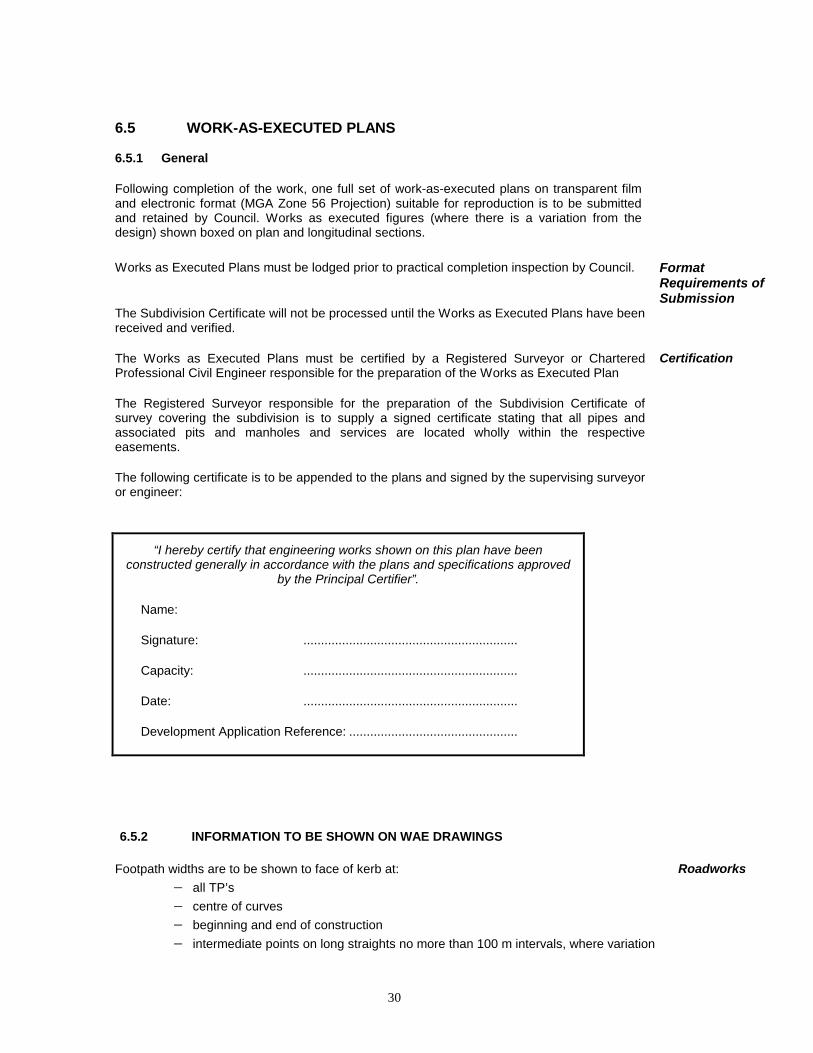
6.5 WORK-AS-EXECUTED PLANS
6.5.1 General
Following completion of the work, one full set of work-as-executed plans on transparent film and electronic format (MGA Zone 56 Projection) suitable for reproduction is to be submitted and retained by Council. Works as executed figures (where there is a variation from the design) shown boxed on plan and longitudinal sections.
Works as Executed Plans must be lodged prior to practical completion inspection by Council.
Format Requirements of Submission
The Subdivision Certificate will not be processed until the Works as Executed Plans have been received and verified.
The Works as Executed Plans must be certified by a Registered Surveyor or Chartered Professional Civil Engineer responsible for the preparation of the Works as Executed Plan
Certification
The Registered Surveyor responsible for the preparation of the Subdivision Certificate of survey covering the subdivision is to supply a signed certificate stating that all pipes and associated pits and manholes and services are located wholly within the respective easements.
The following certificate is to be appended to the plans and signed by the supervising surveyor or engineer:
“I hereby certify that engineering works shown on this plan have been
constructed generally in accordance with the plans and specifications approved by the Principal Certifier”.
Name:
Signature: .............................................................
Capacity: .............................................................
Date: .............................................................
Development Application Reference: ................................................
6.5.2 INFORMATION TO BE SHOWN ON WAE DRAWINGS
Footpath widths are to be shown to face of kerb at: Roadworks − all TP’s − centre of curves − beginning and end of construction − intermediate points on long straights no more than 100 m intervals, where variation
31
exceed +10% from the approved width. Gutter invert levels to be shown at:
− all TP’s − crests − sags − end of straight grades − as required on flat grades
Invert levels of all pipelines at entrance and exit of all pits and headwalls. Stormwater Drainage
Pipe sizes at entrance and exit of all pits and headwalls.
Actual locations, levels and junction positions of interallotment drainage lines.
The location of all pits and pipes within lot boundaries are to be shown by dimensions to nearest boundaries.
The location of conduits, subsoil lines and stubs for further extensions.
Details of overland flow provision.
All other details which have a bearing on the extent of works and their acceptance by the Principal Certifier.
Compaction certificates, lot filling and lot classification which have been prepared by a NATA laboratory. A lot fill diagram shall be provided where lots have been filled. Such diagram shall apply to all lots that have been filled in excess of 300 mm.
Site Regrading
Finished surface levels are to be recorded by spot levels of the regraded area and the natural surface area adjacent.
Spot levels are to taken and recorded on plans at: − allotment corners − centre of front and rear boundaries 12 metres from front alignment on side boundaries and centre of lot
Major site regrading (ie cut or fill over 0.5 m in depth) is to be recorded by new contours.
Depths of fill to be indicated by shading or crosshatching to intervals of 0.5 m
Spot levels are required on all lots within flood prone areas. Flood Prone Areas
6.5.3 INFORMATION TO BE SUBMITTED WITH WORKS AS EXECUTED PLANS
Compaction Certifications (from NATA registered laboratory) for all roadwork pavement construction
- subgrade level - subbase level - base level

32
Material Compliance Certificates for all road pavement
- subbase material - base material
Bitumen spraying records In order to add to Council’s asset management register, it is required that the consultant complete form 14.1 – Road Construction Details for all roads in the development. This form is to be lodged with the Works as Executed plans. The actual contract values of all assets (Roads, stormwater drainage, open space, etc) dedicated to the public shall be submitted.
6.6 COMPLETION OF WORKS AND CERTIFICATION
On practical completion of construction works the Supervising Consultant is to advise the Council to that effect in writing and certify that the whole of the works have been carried out in accordance with the approved plans and specification. If the whole of the works are considered satisfactory the Council will agree to a date (the date of practical completion) on which the whole of the works are considered to have entered into the maintenance period. Unless other wise approved. This date will be the date of release of subdivision.
Maintenance Period
At this stage the Subdivider's Surveyor completes the final property survey and prepares the final plan of subdivision which is known as the "Subdivision Certificate”. The final plan of subdivision plan shall be submitted for endorsement by Council as an original transparency and seven (5) copies. This plan will later be lodged by the Developer with the Registrar General who will prepare title deeds and advise Council of a deposited plan (DP) number so that sale of allotments of land may proceed.
Final Survey
6.7 EARLY RELEASE OF ALLOTMENTS BY APPLICATION OF ENGINEERING BONDS
Council may give consideration to the acceptance of a bond for outstanding engineering works to enable the early release.
Guarantee Bonds
Bonds shall be either a cash security deposit or Bank Guarantee and generally limited to a period of twelve months. All bonds will be calculated at the rate of 1.5 times the contract sum for carrying out the outstanding works.
A bond to guarantee satisfactory completion of bitumen sealing of roadways where applicable.
Asphaltic concrete surfaces may be bonded provided a temporary seal is placed over the pavement and suitable provision for drainage (eg gutter slots) are provided.
Minor associated work such as street signs, medians, linemarking etc may be bonded. Minor Works
Before Council will consider accepting a bond guarantee, the following engineering works within the subdivision must be completed.
• All sewer and water supply works required are complete and have been tested.
• A work-as-executed plan for the sewer works and water supply are to be submitted to Council.
33
• All major engineering problems have been overcome to the satisfaction of the Principal Certifier.
• All works that involve the safety of the public (eg road junctions, flood control structures) are completed.
• Any geotechnical reports regarding the suitability of land for development as required by the Development Consent and Construction Certificate are to be submitted.
• Payment of all fees and contributions required as conditions of development consent are complete.
6.8 MAINTENANCE BOND Following practical completion of all construction works required as a condition of development approval, the developer shall maintain the works to the satisfaction of Council for a period of six (6) months.
Maintenance of Works
The developer shall rectify any omissions, defects or other faults in the works which become apparent during the maintenance period under normal use of the works and which are due to any cause, including design, workmanship or materials.
To ensure that the contractor satisfactorily carries out all maintenance and repairs required during this period the contractor must deposit with Council (or lodge a Bank Guarantee) for a period of six months from the date of practical completion a sum equal to that amount specified in councils fees and charges prior to release of the Subdivision Certificate.
Maintenance Bond
Upon final inspection and satisfactory completion of the maintenance period, the bond shall be released or refunded by Council.
Release of Bond
It is the responsibility of the developer to contact Council to arrange for the final inspection and release of the bond.

34
SUBDIVISION
NEW ASSETS
GENERAL Estate Description/Location: ………………………………………………………………………………….. Supervisor ……………………………………………. Phone: …………………………. Fax: …………………………. Appointed Contractor: ……………………………………………. Phone: …………………………. Fax: …………………………. Developer: …………………………………………… Phone: …………………………. Fax: …………………………. File No/LA: …………………………………………… Construction Certificate No: …………………………………………… Date issued: ……………….. Work as Executed Plans Electronic DXF Format: Operational Services Computer Services Environmental Services To file Issue Practical Completion Certificate: ………………………..(Date) Inspection date: ……………….. (Commencement Maintenance) Maintenance Inspection (End): ………………………………………………………………………………….. ………………………………………………………………………………….. ………………………….. Work completed Issue Completion Certificate: ………………………………..(Date) Total Value of Assets: $……………………………… ROADWORKS Length of New Road (Urban/Rural): …………………………… m Length of kerb and gutter: …………………………… m Value of Asset (Construction Cost): $…………………………..
Form 14.1

35
Pavement: Source Road base Gravel:………………(quarry) ARRB41 Design Depth :…………………(mm) CBR Subgrade :…………………(%) Surface Treatment - 2 Coat flush 7/14mm bitumen seal Applied…………….. Single coat flush 14mm bitumen seal (date) AC10 Concrete Other
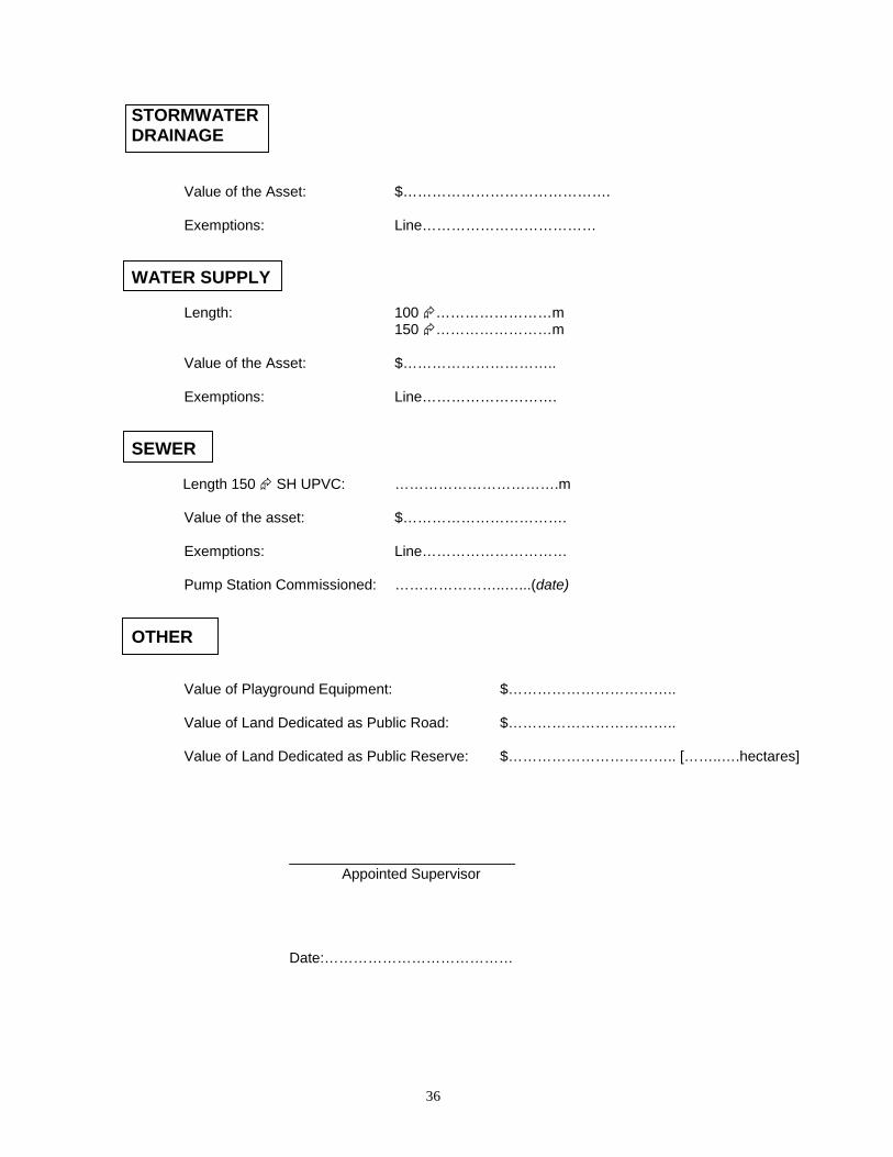
36
STORMWATER DRAINAGE
Value of the Asset: $…………………………………….
Exemptions: Line………………………………
WATER SUPPLY Length: 100 �……………………m 150 �……………………m Value of the Asset: $………………………….. Exemptions: Line………………………. SEWER Length 150 � SH UPVC: …………………………….m Value of the asset: $……………………………. Exemptions: Line………………………… Pump Station Commissioned: …………………..…...(date) OTHER Value of Playground Equipment: $…………………………….. Value of Land Dedicated as Public Road: $…………………………….. Value of Land Dedicated as Public Reserve: $…………………………….. [……..….hectares] ____________________________ Appointed Supervisor Date:…………………………………