Engineering Guidelines TrainingEngineering...Engineering Guidelines Training NJ Living Shorelines...
33
Engineering Guidelines Training NJ Living Shorelines Guidelines Jon K. Miller Andrew Rella Amy Williams May 29, 2015
Transcript of Engineering Guidelines TrainingEngineering...Engineering Guidelines Training NJ Living Shorelines...

Engineering Guidelines Training
NJ Living Shorelines Guidelines
Jon K. Miller
Andrew Rella
Amy Williams
May 29, 2015

Objectives
• Provide guidance to engineers and contractors on the engineering components of living shorelines
design
• Provide a common starting place to ensure consistency with GP 29 (N.J.A.C. 7:7-7.29) – “Living
Shorelines GP”
• Reduce the number of failures due to poor engineering/construction
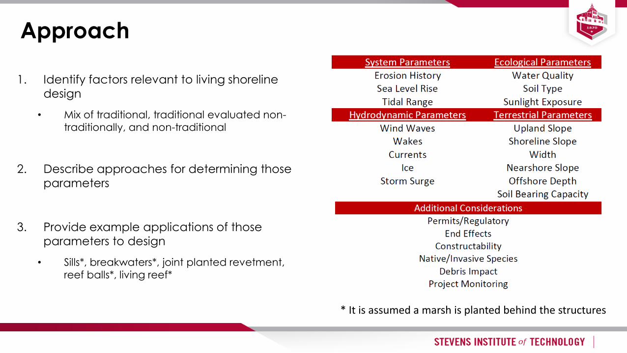
Approach
1. Identify factors relevant to living shoreline
design
• Mix of traditional, traditional evaluated non-
traditionally, and non-traditional
2. Describe approaches for determining those
parameters
3. Provide example applications of those
parameters to design
• Sills*, breakwaters*, joint planted revetment,
reef balls*, living reef*
* It is assumed a marsh is planted behind the structures

Suggested Design Approach

ALTERNATIVE SELECTION
Parameters
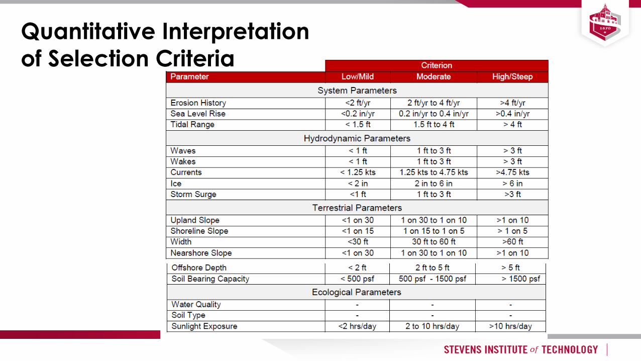
Quantitative Interpretation
of Selection Criteria

SYSTEM PARAMETERS
Erosion History
Sea Level
Tidal Rage

Erosion History
• Define the problem
• Desktop Analysis
• Compare historical maps

Sea Level Rise
• Landscape features may drown
in place
• Desktop Analysis
• Alternatives analysis
• USACE and NOAA Guidance

Tide Range
• Determines amount of
overtopping/transmission
• Vegetation is extremely sensitive to
its position with respect to the tide
• Invertebrate growth is sensitive to
position within the water column

HYDRODYNAMIC PARAMETERS
Wind Waves
Wakes
Currents
Ice
Storm Surge
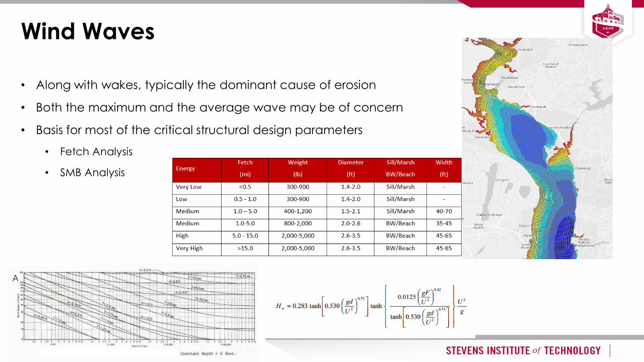
Wind Waves
• Along with wakes, typically the dominant cause of erosion
• Both the maximum and the average wave may be of concern
• Basis for most of the critical structural design parameters
• Fetch Analysis
• SMB Analysis
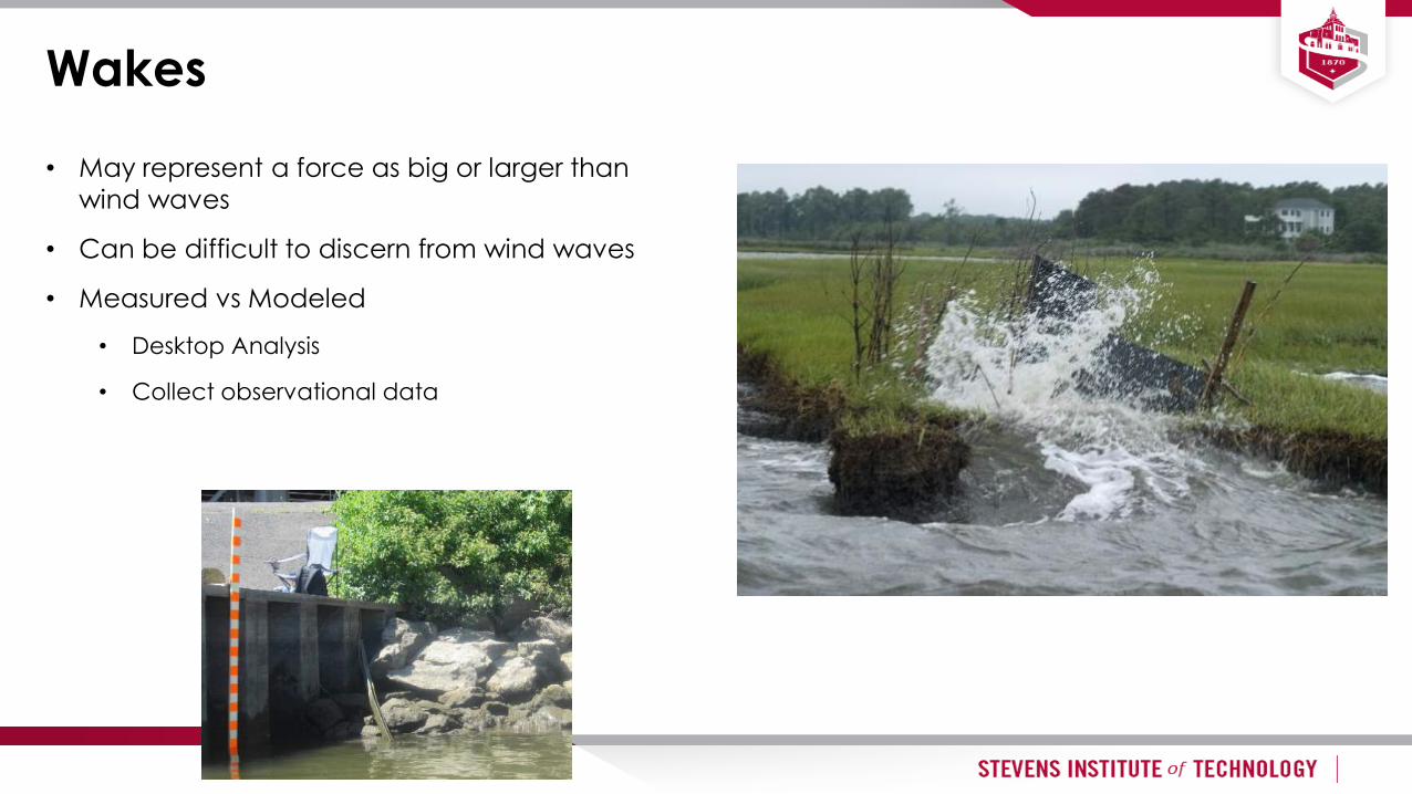
Wakes
• May represent a force as big or larger than
wind waves
• Can be difficult to discern from wind waves
• Measured vs Modeled
• Desktop Analysis
• Collect observational data

Currents
• Can uproot vegetation
• Transports ice and debris
• Scour
• Desktop Analysis
• NOAA, USGS, USACE, local climatologists

Ice
• Known to be important, but data lacking
• Desktop Analysis
• Ice climatology (US Coast Guard obs)
• Satellite Imagery (no info on thickness)

Storm Surge
• Surge can be less important because water overtops the structure
• Desktop Analysis
• FEMA flood maps
• NOAA tides and currents extreme water level analyses

TERRESTRIAL PARAMETERS
Upland Slope
Shoreline Slope
Width
Nearshore Slope
Offshore Depth
Soil Bearing

Upland Slope
• Measured from approximately spring high water to point at which upland levels off
• Critical for vegetation
• Milder slopes have less scarping
• Desktop Analysis
• DEM’s, LIDAR
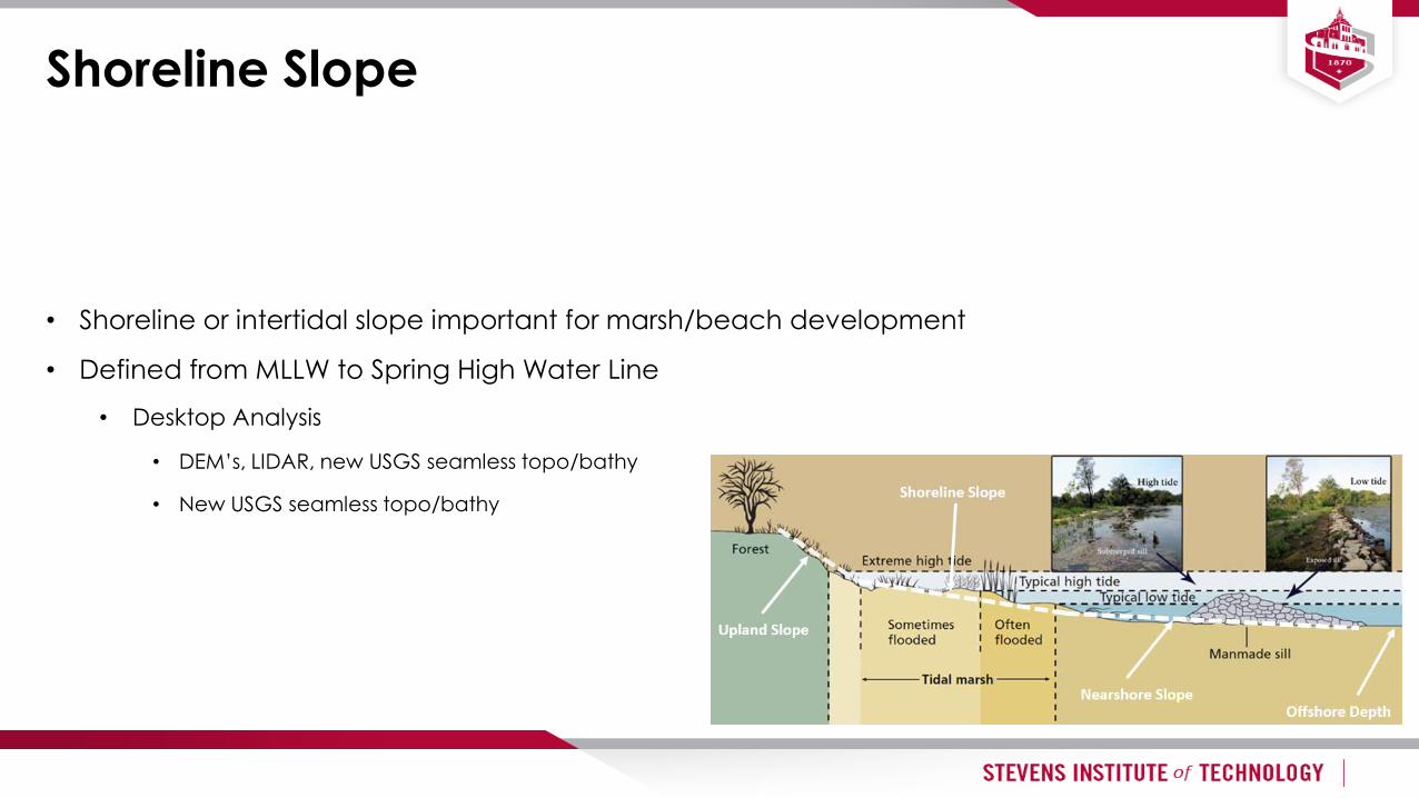
Shoreline Slope
• Shoreline or intertidal slope important for marsh/beach development
• Defined from MLLW to Spring High Water Line
• Desktop Analysis
• DEM’s, LIDAR, new USGS seamless topo/bathy
• New USGS seamless topo/bathy

Nearshore Slope
• Influences nearshore waves and currents
• Influence depth at structure
• Stable platform required for structure
• Desktop Analysis
• NOAA, Bathymetric charts/DEM’s

Offshore Depth
• Influences nearshore waves
• Influences size of structure and amount of fill
• Desktop Analysis
• NOAA, Bathymetric charts/DEM’s
• Bathymetric Survey
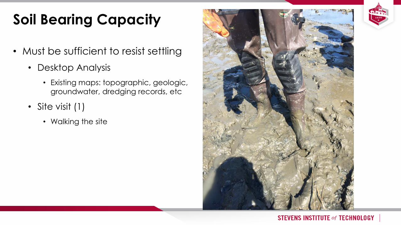
Soil Bearing Capacity
• Must be sufficient to resist settling
• Desktop Analysis
• Existing maps: topographic, geologic,
groundwater, dredging records, etc
• Site visit (1)
• Walking the site
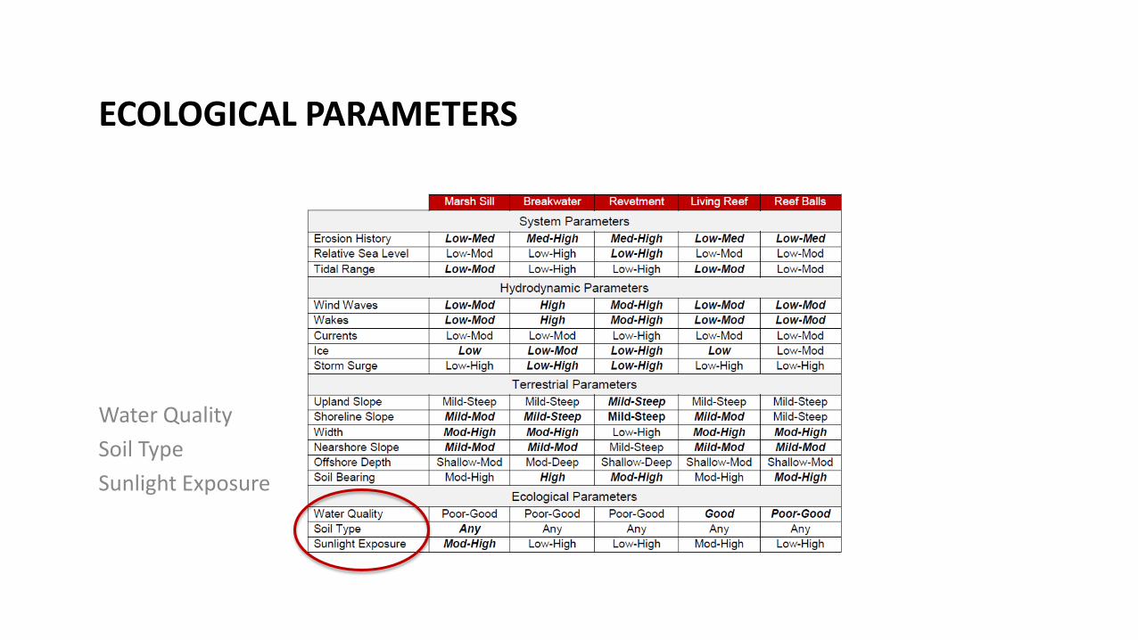
ECOLOGICAL PARAMETERS
Water Quality
Soil Type
Sunlight Exposure

Water Quality
• Impacts growing conditions for both flora and fauna
• Primary parameters
• Dissolved Oxygen – produced by photosynthesis, consumed during respiration
• Varies seasonally, daily tidally, with depth
• NJ State Surface Water Quality Criteria
• Desktop Analysis
• USGS, EPA, NJDEP, Universities, NGO’s
• Consult a biologist/ecologist

Soil Type
• Soil conditions impact growth rate and root penetration
• Desktop Analysis (1)
• GIS Maps, Existing soil records, Dredge spoil (dumping) records

Sunlight Exposure
• Sunlight is required for photosynthesis which impact water quality
• Terrestrial vegetation also requires sunlight
• Desktop Analysis
• Google earth, bing
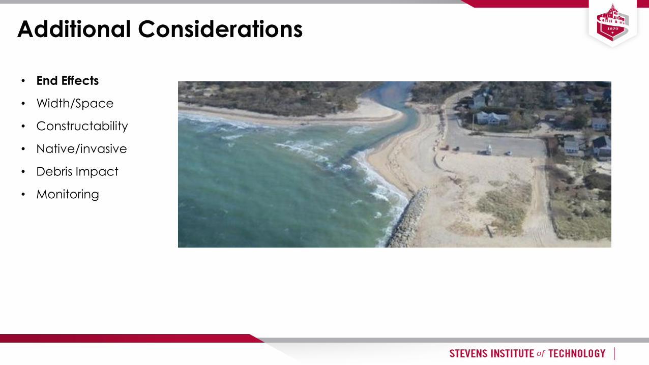
Additional Considerations
• End Effects
• Width/Space
• Constructability
• Native/invasive
• Debris Impact
• Monitoring

Additional Considerations
• End Effects
• Width/Space
• Constructability
• Native/invasive
• Debris Impact
• Monitoring
• A marsh requires a minimum amount of space
• Beaches/marshes provide additional energy dissipation
• Most states prohibit fill below MHW
• NJ allows fill to the 1977 tidelands map for restoration activities

Additional Considerations
• End Effects
• Width/Space
• Constructability
• Native/invasive
• Debris Impact
• Monitoring

Additional Considerations
• End Effects
• Width/Space
• Constructability
• Native/invasive
• Debris Impact
• Monitoring
Phragmites australis

Additional Considerations
• End Effects
• Width/Space
• Constructability
• Native/invasive
• Debris Impact
• Monitoring

Additional Considerations
• End Effects
• Width/Space
• Constructability
• Native/invasive
• Debris Impact
• Monitoring
“Build and Maintain”

Websites for Analysis
33
• Google Earth
• www.historicaerials.com
• US Army Corps guidance/procedure
• http://www.corpsclimate.us/docs/EC_1165-2-212%20-
Final_10_Nov_2011.pdf
• NOAA guidance
• http://www.habitat.noaa.gov/pdf/slr_workshop_report_nove
mber_2011.pdf
• NOAA (http://tidesandcurrents.noaa.gov/curr_pred.html)
• USGS (http://waterdata.usgs.gov/nj/nwis/rt)
• US Army Corps of Engineers (http://cirp.usace.army.mil/)
• Local climatologies (https://www.hrnerr.org/hudson-river-
sustainable-shorelines/shorelines-engineering/physical-forces-
statistics/)
• DEM’s (http://www.state.nj.us/dep/gis/)
• Lidar (http://www.csc.noaa.gov/)
• NOAA (http://estuarinebathymetry.noaa.gov/midatlantic.html)
• USGS (http://nj.usgs.gov/infodata/waterquality.html)
• EPA
(http://iaspub.epa.gov/tmdl/attains_state.control?p_state=NJ&p_
cycle=2006)
• NJDEP (http://www.state.nj.us/dep/wms/wqde/)
• Universities (http://www.monmouth.edu/university/coastal-water-
quality-real-time-monitoring-program-ver-2.aspx)
• NGO’s (http://nynjbaykeeper.org/resources-programs/advocacy-
legal-campaigns/how-is-the-water/)