DC CLEAN RIVERS PROJECT Northeast Boundary Tunnel · 28/4/2015 · DC CLEAN RIVERS PROJECT...
15
1 DC CLEAN RIVERS PROJECT Northeast Boundary Tunnel Briefing on: Briefing for: Trinidad Civic Association April 28, 2015 District of Columbia Water and Sewer Authority George S. Hawkins, General Manager
Transcript of DC CLEAN RIVERS PROJECT Northeast Boundary Tunnel · 28/4/2015 · DC CLEAN RIVERS PROJECT...

1
DC CLEAN RIVERS PROJECT
Northeast Boundary Tunnel
Briefing on:
Briefing for:
Trinidad Civic Association
April 28, 2015
District of Columbia Water and Sewer Authority George S. Hawkins, General Manager

2
Long Term Control Plan (LTCP) to: Relieve flooding in the Northeast
Boundary Area
Control combined sewer overflows to: Potomac River
Anacostia River
Rock Creek
Meet nutrient discharge limits of
Chesapeake Bay Program
Schedule: 2005-2025
Implemented under a Federal Consent
Decree among: United States Environmental
Protection Agency (US EPA)
United States Department of Justice
(US DOJ)
District of Columbia
DC Water
2
Background
Project Snapshot
2
Lady Bird Mining Location
3
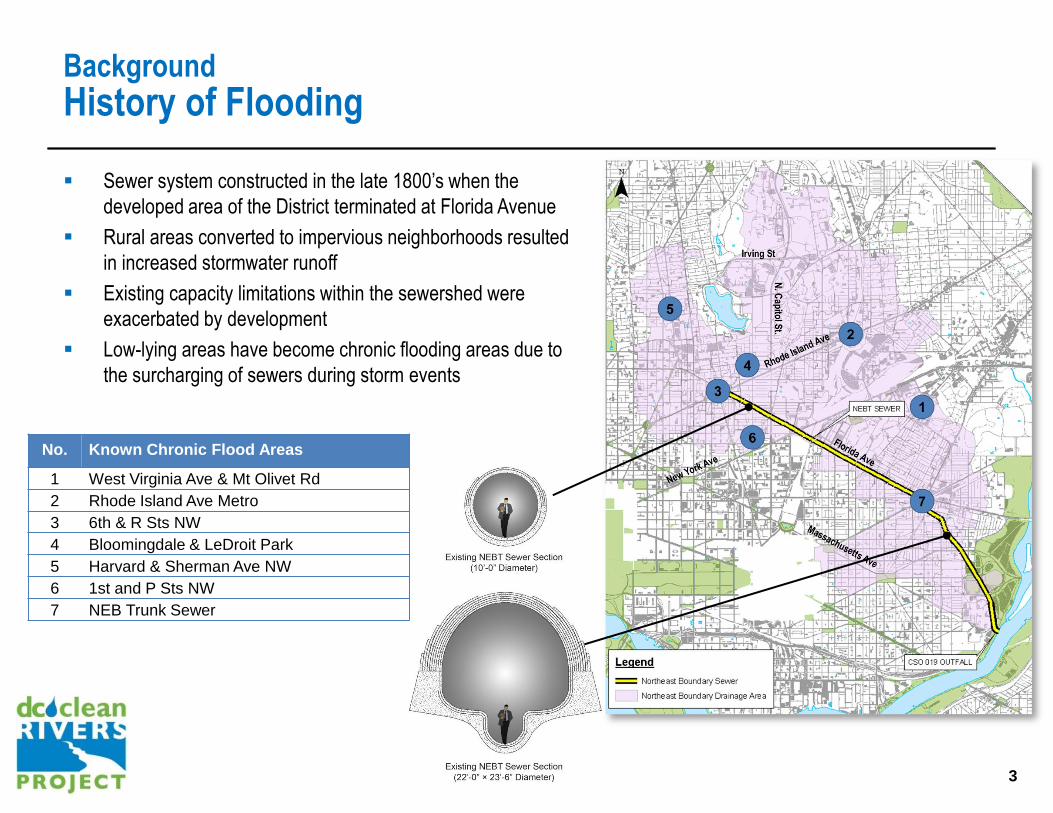
Background
History of Flooding
Sewer system constructed in the late 1800’s when the
developed area of the District terminated at Florida Avenue
Rural areas converted to impervious neighborhoods resulted
in increased stormwater runoff
Existing capacity limitations within the sewershed were
exacerbated by development
Low-lying areas have become chronic flooding areas due to
the surcharging of sewers during storm events
No. Known Chronic Flood Areas
1 West Virginia Ave & Mt Olivet Rd
2 Rhode Island Ave Metro
3 6th & R Sts NW
4 Bloomingdale & LeDroit Park
5 Harvard & Sherman Ave NW
6 1st and P Sts NW
7 NEB Trunk Sewer
3
4
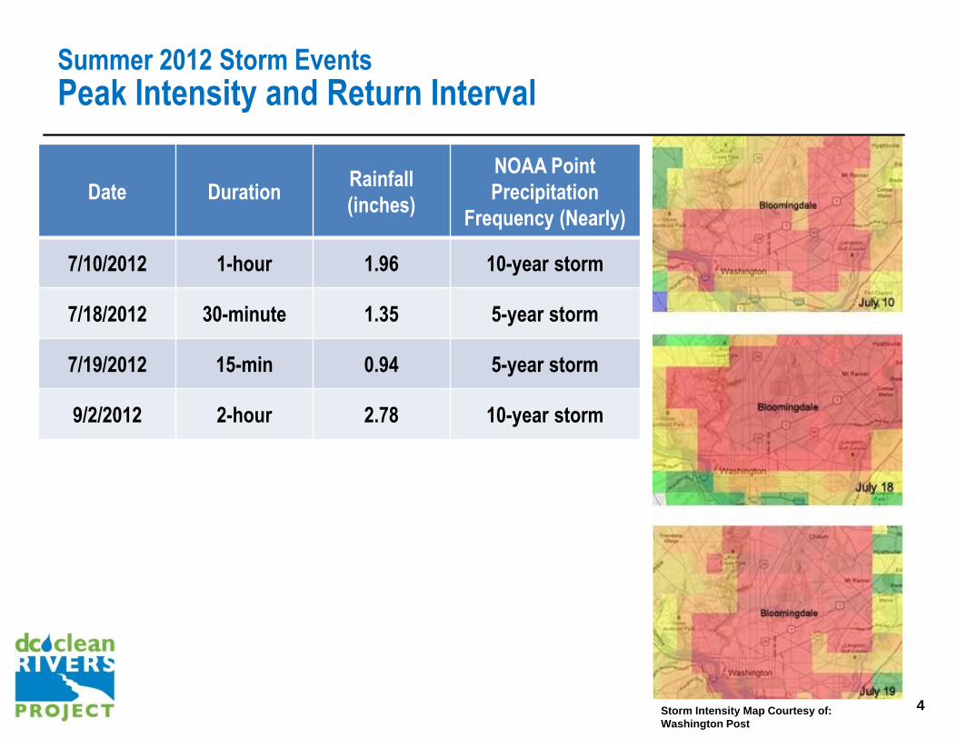
Summer 2012 Storm Events
Peak Intensity and Return Interval
Date Duration Rainfall
(inches)
NOAA Point
Precipitation
Frequency (Nearly)
7/10/2012 1-hour 1.96 10-year storm
7/18/2012 30-minute 1.35 5-year storm
7/19/2012 15-min 0.94 5-year storm
9/2/2012 2-hour 2.78 10-year storm
4 Storm Intensity Map Courtesy of:
Washington Post
5
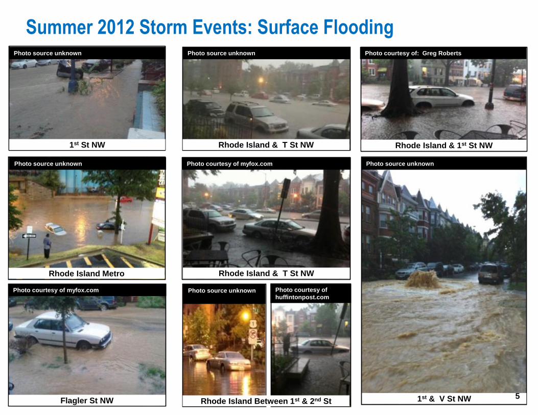
Summer 2012 Storm Events: Surface Flooding
Rhode Island Metro
1st St NW
Flagler St NW
Rhode Island & T St NW
Rhode Island Between 1st & 2nd St
Rhode Island & T St NW
Rhode Island & 1st St NW
5 1st & V St NW
Photo courtesy of: Greg Roberts
Photo courtesy of
huffintonpost.com
Photo courtesy of myfox.com
Photo courtesy of myfox.com
5
Photo source unknown
Photo source unknown
Photo source unknown
Photo source unknown
Photo source unknown

6
Mayor’s Task Force
Overview
4 storms caused major
flooding: July 10, 18, 19
and Sept 2, 2012
Mayor formed Task
Force in Aug 2012
Task Force report
delivered end of Dec
2012
Over 25 Recommendations:
Engineering Measures • McMillan Stormwater Storage
• First Street Tunnel
• Northeast Boundary Tunnel
(NEBT)
Regulatory Code Changes Operations &
Maintenance Public
Outreach
6

7
Mayor’s Task Force
Recommended Plan
7
NORTHEAST BOUNDARY TUNNEL PROJECT A large, deep sewer tunnel that will increase the capacity of
the sewer system to current design standards and control combined sewer overflow discharges to the Anacostia River
Completion in 2022
MCMILLAN STORMWATER STORAGE PROJECT Repurpose McMillan Sand Filtration cells as stormwater
storage In-line storage in a sewer that runs along First Street NW 3.6 million gallons. Completed
IRVING STREET GREEN INFRASTRUCTURE PROJECT Construction of bioretention facilities along Irving Street NW 0.4 million gallons. Completed
FIRST STREET TUNNEL PROJECT Construction of a new tunnel under First Street NW Construction of diversion facilities to divert flows to tunnel 8 million gallons, Completion in Spring 2016
2. MEDIUM-TERM
3. LONG-TERM
Construction of green infrastructure projects Installation of storm drains and a five-foot-wide storm sewer Backwater valve and rain barrel program
1. SHORT-TERM (NOT ILLUSTRATED)
N
9
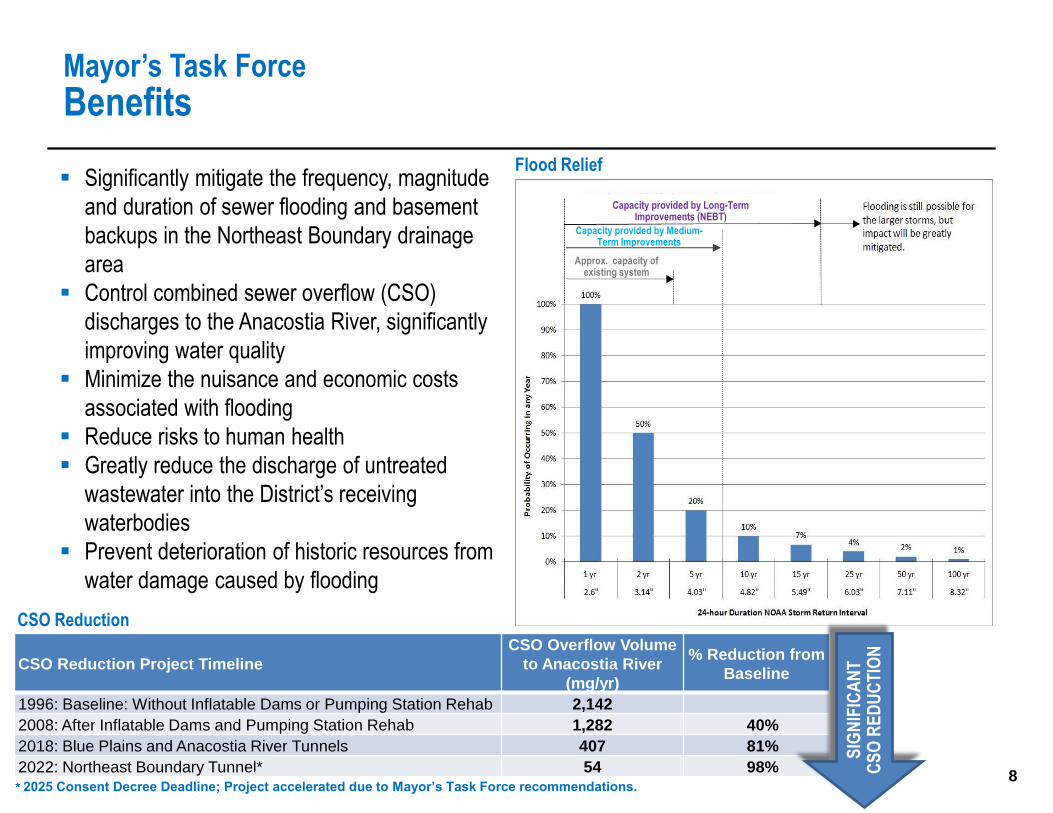
8
Significantly mitigate the frequency, magnitude
and duration of sewer flooding and basement
backups in the Northeast Boundary drainage
area
Control combined sewer overflow (CSO)
discharges to the Anacostia River, significantly
improving water quality
Minimize the nuisance and economic costs
associated with flooding
Reduce risks to human health
Greatly reduce the discharge of untreated
wastewater into the District’s receiving
waterbodies
Prevent deterioration of historic resources from
water damage caused by flooding
Mayor’s Task Force
Benefits
CSO Reduction Project Timeline
CSO Overflow Volume
to Anacostia River
(mg/yr)
% Reduction from
Baseline
1996: Baseline: Without Inflatable Dams or Pumping Station Rehab 2,142
2008: After Inflatable Dams and Pumping Station Rehab 1,282 40%
2018: Blue Plains and Anacostia River Tunnels 407 81%
2022: Northeast Boundary Tunnel* 54 98%
CSO Reduction
* 2025 Consent Decree Deadline; Project accelerated due to Mayor’s Task Force recommendations. 8
Flood Relief
SIG
NIF
ICA
NT
C
SO
RE
DU
CT
ION
Capacity provided by Long-Term Improvements (NEBT)
Approx. capacity of existing system
Capacity provided by Medium-Term Improvements
9
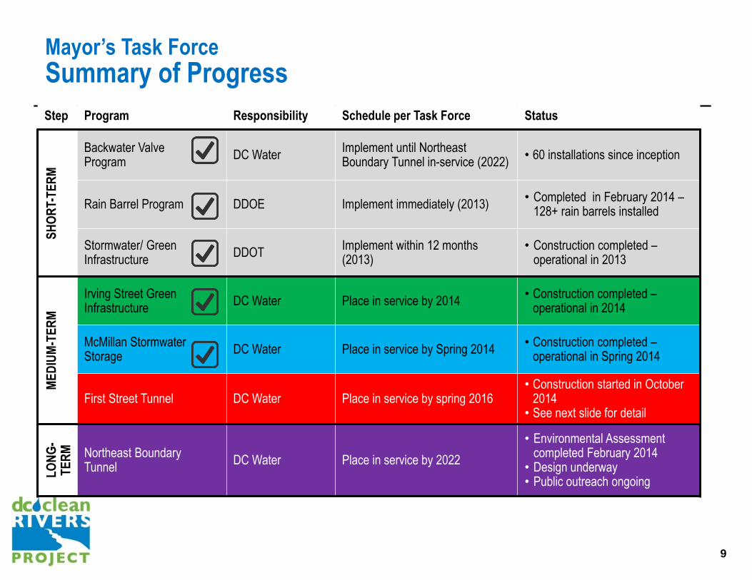
Mayor’s Task Force
Summary of Progress
9
Step Program Responsibility Schedule per Task Force Status
SH
OR
T-T
ER
M
Backwater Valve Program DC Water
Implement until Northeast Boundary Tunnel in-service (2022)
• 60 installations since inception
Rain Barrel Program DDOE Implement immediately (2013) • Completed in February 2014 –
128+ rain barrels installed
Stormwater/ Green Infrastructure
DDOT Implement within 12 months (2013)
• Construction completed – operational in 2013
ME
DIU
M-T
ER
M
Irving Street Green Infrastructure
DC Water Place in service by 2014 • Construction completed –
operational in 2014
McMillan Stormwater Storage
DC Water Place in service by Spring 2014 • Construction completed –
operational in Spring 2014
First Street Tunnel DC Water Place in service by spring 2016 • Construction started in October
2014 • See next slide for detail
LO
NG
-T
ER
M
Northeast Boundary Tunnel
DC Water Place in service by 2022
• Environmental Assessment completed February 2014
• Design underway • Public outreach ongoing
10
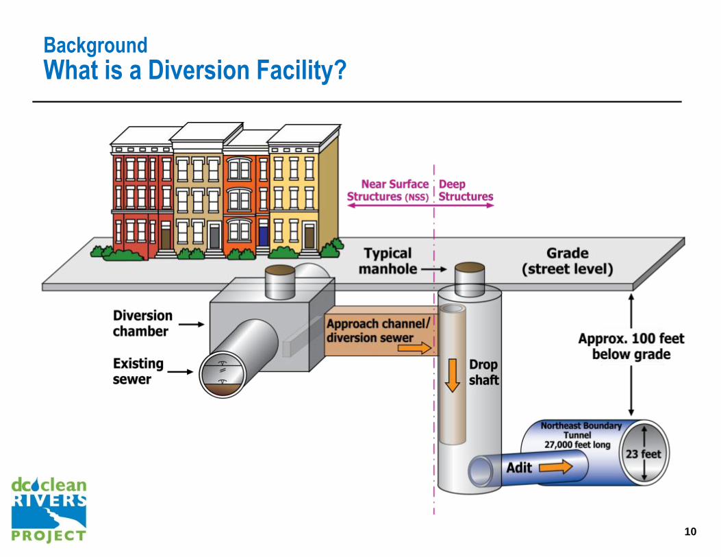
Background
What is a Diversion Facility?
10

11
Northeast Boundary Tunnel
Alignment and Chronic Flood Areas
11
Significant Work
along Rhode
Island Avenue
Corridor

12
Northeast Boundary Tunnel
Mitigation Measures
12
Public outreach during
planning and design
• Contract milestones • Advanced utility relocations • Collaboration process –
selected best value
• Pre-post-construction surveys • 24/7 hotline • Security service • Vector control • Street cleanings • Noise attenuation • Noise & vibration specialist
Incorporate mitigation measures into design and
construction
MINIMIZE DURATION MINIMIZE IMPACTS
• Traffic Study (Transit, Pedestrian and Bicycle included) •Off-peak hauling • Compact construction sites •Maintain access/services • Extensive coordination with
District agencies
MAINTAIN QUALITY OF LIFE

13
Northeast Boundary Tunnel
Utility Relocation
Utility Relocation
Gas and electric, communications, water and sewer utilities in vicinity
of the near surface structures (NSS) along the Northeast Boundary
Tunnel alignment will be relocated
Informational sheets with map will be hand delivered to residents
within the affected area
Work will begin in June 2016 and extend through April 2017. Work
will be concentrated at individual sites for the duration required per
site
Schedule and duration at sites is currently being developed
13
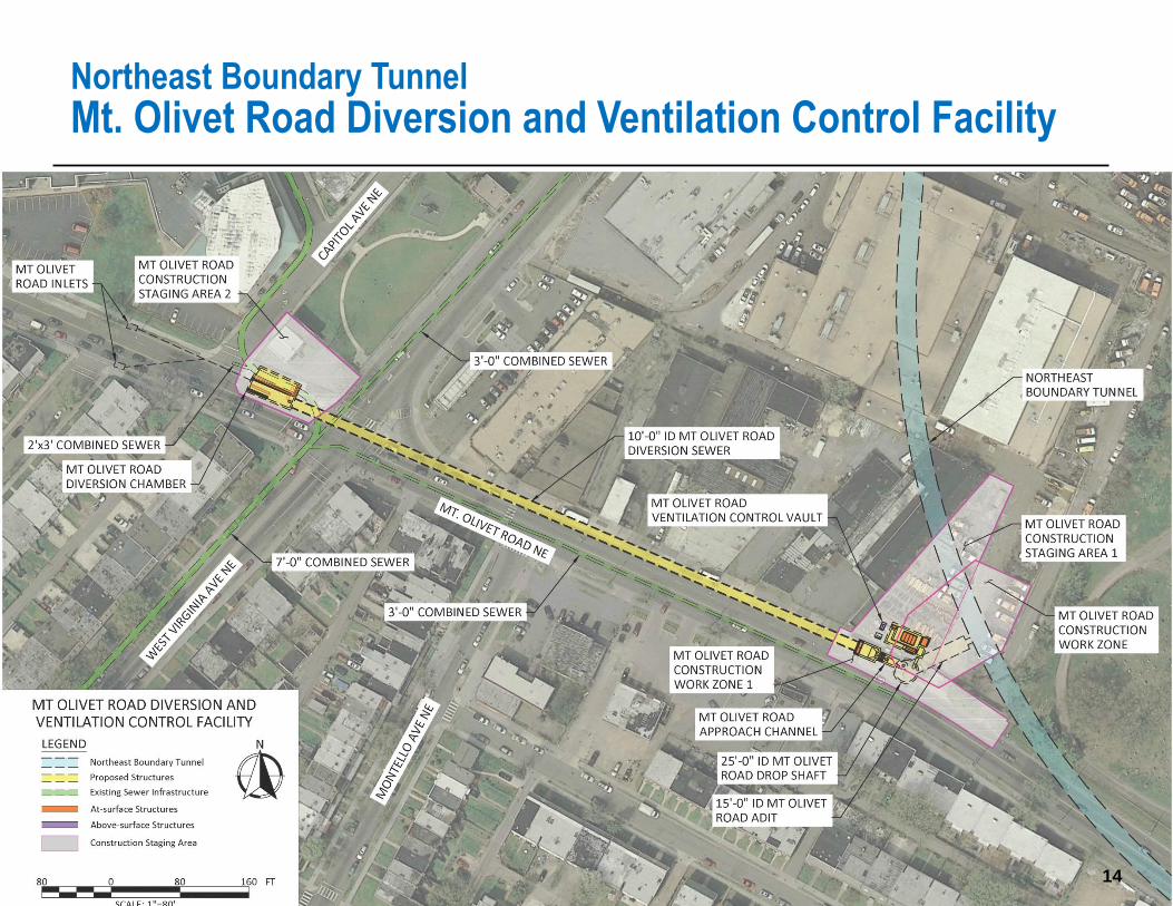
14 14 14
Northeast Boundary Tunnel
Mt. Olivet Road Diversion and Ventilation Control Facility
14 14
15
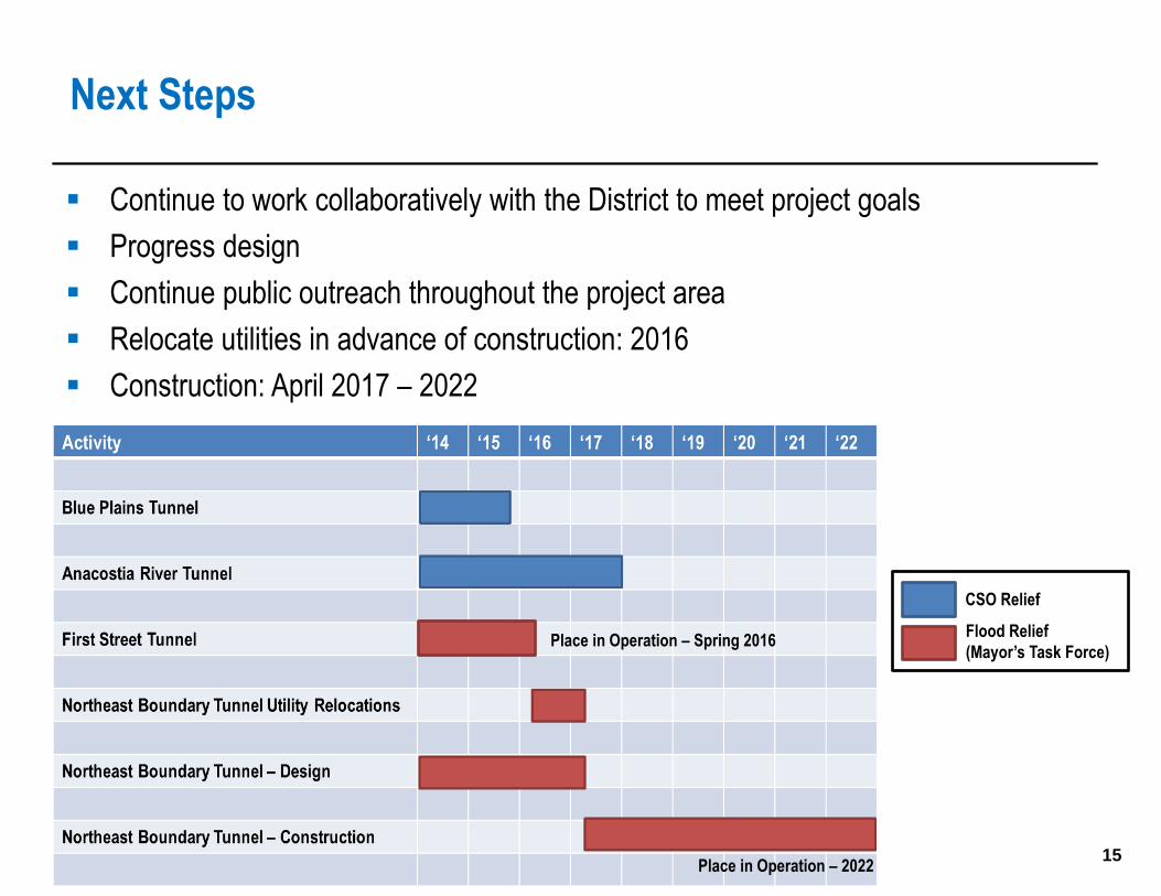
Next Steps
15
Place in Operation – Spring 2016
Place in Operation – 2022
CSO Relief
Flood Relief
(Mayor’s Task Force)
Continue to work collaboratively with the District to meet project goals
Progress design
Continue public outreach throughout the project area
Relocate utilities in advance of construction: 2016
Construction: April 2017 – 2022


![EFFECT OF HUMAN ACTIVITY ON RIVERS - DSİ - Ana · PDF fileEFFECT OF HUMAN ACTIVITY ON RIVERS ... tunnel or pipeline to ... [Stadnitskiy, Rodionov, 1996]. Water losses in irrigation](https://static.fdocuments.in/doc/165x107/5aa0e0157f8b9a71178ecb30/effect-of-human-activity-on-rivers-dsi-ana-of-human-activity-on-rivers-.jpg)