Darwin Initiative Annual Reportdoe.ky/wp-content/uploads/2015/01/DarwinPP_Annual_… · ·...
54
Annual Report template with notes 2014 1 Darwin Initiative Annual Report Important note: To be completed with reference to the Reporting Guidance Notes for Project Leaders: it is expected that this report will be about 10 pages in length, excluding annexes Submission Deadline: 30 April Darwin Project Information Project Reference EIDPO045 (Post-project) Project Title Assuring engagement in Cayman’s enhanced marine protected area system Host Country/ies Cayman Islands Contract Holder Institution Bangor University, Wales (School of Ocean Sciences) SOS Partner institutions Cayman Islands Government Department of Environment (DoE) and Department of Computer Services (CS), The Nature Conservancy, USA (TNC), Scripps Institution of Oceanography, USA (SIO), Reef Environmental Education Foundation, USA (REEF) Darwin Grant Value £190,000 Start/end dates of project 1 April 2013 – 30 September 2014 Reporting period (eg Apr 2013 – Mar 2014) and number (eg Annual Report 1, 2, 3) April 2013 – March 2014 Annual Report 1 Project Leader name Dr John Turner, Bangor University Project website http://www.DoE.ky/marine/25-years-of-marine-parks/ Report author(s) and date John Turner, PI, Croy McCoy,Co-PI, Laura Richardson & Charli Mortimer (Project Support Officers) 1. Project Rationale The Cayman Islands The Cayman Islands are a UK Overseas Territory located centrally in the Caribbean (Grand Cayman 19° 20′ 0″ N, 81° 13′ 0″ W; Little Cayman 19° 41′ 0″ N, 80° 02′ 0″ W; Cayman Brac 19° 43′ 0″ N, 79° 48′ 0″ W; Fig. 1), with strong financial and tourism sectors, and negligible industry, run off or agricultural impact. The islands present a rich marine environment, benefiting from 25 years of world-class in situ conservation through the active enforcement of zoned Marine Protected Areas (MPAs). Prior to the Main Project: ‘Darwin Initiative to enhance an established Marine Protected Area system, Cayman Islands’ Cayman’s Department of the Environment had diligently maintained and monitored MPAs, and, despite identifying the urgent need to review the MPA system to address development and climate change, had insufficient resources to scientifically assess their effectiveness to make an informed case for their expansion. Further, it was envisaged that an enhanced MPA system would demonstrate globally what far-sighted in situ conservation can achieve in building resilience back into ecosystems.
Transcript of Darwin Initiative Annual Reportdoe.ky/wp-content/uploads/2015/01/DarwinPP_Annual_… · ·...

Annual Report template with notes 2014 1
Darwin Initiative Annual Report
Important note: To be completed with reference to the Reporting Guidance Notes for Project Leaders:
it is expected that this report will be about 10 pages in length, excluding annexes
Submission Deadline: 30 April
Darwin Project Information
Project Reference EIDPO045 (Post-project)
Project Title Assuring engagement in Cayman’s enhanced marine protected area system
Host Country/ies Cayman Islands
Contract Holder Institution Bangor University, Wales (School of Ocean Sciences) SOS
Partner institutions Cayman Islands Government Department of Environment
(DoE) and Department of Computer Services (CS), The Nature Conservancy, USA (TNC), Scripps Institution of Oceanography, USA (SIO), Reef Environmental Education Foundation, USA (REEF)
Darwin Grant Value £190,000
Start/end dates of project 1 April 2013 – 30 September 2014
Reporting period (eg Apr 2013 – Mar 2014) and number (eg Annual Report 1, 2, 3)
April 2013 – March 2014
Annual Report 1
Project Leader name Dr John Turner, Bangor University
Project website http://www.DoE.ky/marine/25-years-of-marine-parks/
Report author(s) and date John Turner, PI, Croy McCoy,Co-PI, Laura Richardson & Charli Mortimer (Project Support Officers)
1. Project Rationale
The Cayman Islands
The Cayman Islands are a UK Overseas Territory located centrally in the Caribbean (Grand Cayman 19° 20′ 0″ N, 81° 13′ 0″ W; Little Cayman 19° 41′ 0″ N, 80° 02′ 0″ W; Cayman Brac 19° 43′ 0″ N, 79° 48′ 0″ W; Fig. 1), with strong financial and tourism sectors, and negligible industry, run off or agricultural impact. The islands present a rich marine environment, benefiting from 25 years of world-class in situ conservation through the active enforcement of zoned Marine Protected Areas (MPAs). Prior to the Main Project: ‘Darwin Initiative to enhance an established Marine Protected Area system, Cayman Islands’ Cayman’s Department of the Environment had diligently maintained and monitored MPAs, and, despite identifying the urgent need to review the MPA system to address development and climate change, had insufficient resources to scientifically assess their effectiveness to make an informed case for their expansion. Further, it was envisaged that an enhanced MPA system would demonstrate globally what far-sighted in situ conservation can achieve in building resilience back into ecosystems.

Annual Report template with notes 2014 2
Figure 1 The Cayman Islands of Grand Cayman, Little Cayman and Cayman Brac and their position in the Caribbean.
The Main Project Outcome was: ‘A review of the effectiveness of the Marine Protected Area system of the Cayman islands in maintaining resilience of coral reefs and shallow marine ecosystems in response to direct human impact and climate change, and if appropriate, to provide the information base to extend the system to increase that effectiveness.’ The main achievements of the original project were:
(1) Assessment of resilience: reef health measured at 62 permanently established monitoring sites inside and outside of the current MPA system, showed that the MPAs generally provide local resilience. (Higher cover and coral recruitment, lower coral bleaching, disease prevalence and macroalgal cover).
(2) Assessment of benefit: overspill of fish into surrounding waters was evident at some MPA boundaries. Number, size and biomass of 53 target fish species was greater in many MPAs than outside, and proportions of herbivorous and carnivorous fish were more balanced. However, invasive lionfish threaten fish communities.
(3) Assessment of fisheries impact: recreational, artisanal and illegal fishing are significant on Cayman reefs, and fishers exploited the MPA boundaries. Fishing is an important part of Caymanian culture, and understanding the incentives to fish legally and illegally must be included in conservation planning. Fish spawning aggregation sites (SPAGs) have been identified as being vulnerable to overexploitation.
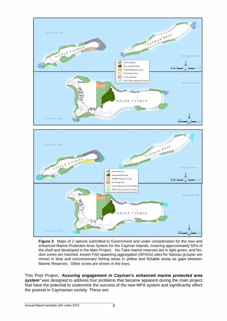
(4) Stakeholder consultation, survey data and protected area planning tools have been used to plan an enhanced MPA system which increases No-take protection from 15 to 50% of the shelf (Figure 2), but provides access to fishable areas. A campaign of public awareness, education and consultation maximised understanding and support for the new MPA system, included 34 public events, 21 press articles, 24 TV and 5 radio programmes, 16 online items, 24 scientific papers, theses, reports and conference presentations and 10 other outputs (eg. school information packs, MPA promotions). The enhanced MPA system (Figure 2) has been submitted to Government and we are currently await approval from Cabinet.
Annual Report template with notes 2014 3
Figure 2: Maps of 2 options submitted to Government and under consideration for the new and enhanced Marine Protected Area System for the Cayman Islands, covering approximately 50% of the shelf and developed in the Main Project. No-Take marine reserves are in light green, and No-dive zones are hatched, known Fish spawning aggregation (SPAGs) sites for Nassau grouper are shown in blue and concessionary fishing areas in yellow and fishable areas as gaps between
Marine Reserves. Other zones are shown in the keys.
This Post Project, ‘Assuring engagement in Cayman’s enhanced marine protected area system’ was designed to address four problems that became apparent during the main project that have the potential to undermine the success of the new MPA system and significantly affect the poorest in Caymanian society. These are:

Annual Report template with notes 2014 4
(1) Invasive lionfish (Pterois volitans); the abundance, distribution and impact of lionfish have since been examined and their growing population and impact on reefs is now apparent, although this was not a problem when the Main Project was conceived. DOE deployed its own resources into a culling programme. The Post Project will assess the effect of culling lionfish, utilising MPA zones.
(2) Fishing at Spawning Aggregation Sites (SPAGs) rapidly decimates adult fish; 5 out of 6 aggregation sites of Nassau grouper have been lost, forcing seasonal closure of the last. Fishers now target other species of fish, necessitating sustainable management. The project will assess multi-species SPAGs by resourcing monthly in-water surveys after full-moon.
(3) The project will resource surveys of fish overspill into concessionary fishing areas (‘slots’) between No-Take MPAs, since these allow fishing at the MPA boundaries, especially by the poorest fishers who cannot afford boat fuel to fish further afield.
(4) Most illegal fishing occurs in highly populated districts, especially when work is scarce and meat expensive; and repeat offenders often do so to fuel drug and alcohol addictions. The economic downturn means that Government cannot resource an expansion in enforcement to match the expansion in MPAs, and therefore the Post Project plans to resource an innovative solution to assist enforcement involving the general public.
Therefore, the enhanced MPA faces 4 challenges, identified from field study and stakeholder interaction:
(1) Invasive species control: Lionfish culling programmes are believed to mitigate the impact of lionfish on reef-fish communities, but are resource intensive. Reduced sightings in culled zones may be due to lionfish learning to avoid divers, rather than culling being effective – in which case, resources could be better deployed.
(2) Protection of fish spawning aggregations (SPAGs): Historically exploited by fishers, SPAGs are now seasonally closed for fishing of Nassau grouper to allow stocks to recover. But, the sites appear important for 26 other species of reef fish potentially all year round. A No-Take designation must be justified, and mitigated, due to displacement and possible non-acceptance amongst the poorest fishers.
(3) Sustainability of concessions to fishers: The enhanced MPA system provides fishing at MPA boundaries opposite community boat-ramps, minimising fishers’ fuel costs. But fish overspill from MPA must be monitored and adaptive management introduced if fishers are to benefit long-term.
(4) MPA enforcement dilution: Expansion of No-Take MPAs from 15% to 50% of the Cayman shelf requires an expansion in enforcement, but there are no resources to achieve this target. An innovative approach is planned using a wireless tablet system to allow Enforcement Officers at link to the permit database system and to make reports from the field, and a smart phone public application is planned to allow the public to engage with the MPA system in real time by accessing information or making anonymous reports of transgressions or interesting sightings.
2. Project Partnerships
The Partners The core project team is comprised of Dr John Turner (Project Leader, SOS Bangor University), Gina Ebanks-Petrie & Tim Austin (PIs, Directors of main Project Partner and Host-country Co-ordinator, DOE, Cayman Islands Government), Croy McCoy (Co-PI Darwin Fellow, DoE), and James Byrne (Regional Partner, TNC, USA), Brice Semmens (Project Partner, SIO), Christy Pattengill-Semmens (Project Partner, REEF) and Laura Richardson/Charli Mortimer (Project Support Officer, SOS and DoE). The roles, responsibilities and relationship to the project of each collaborating partner are:
Cayman Islands Government Department of Environment (DoE; Lead Host-country Partner: The Department of the Environment (DoE) is under the Cayman Islands Ministry for Tourism, Environment, Investment and Commerce (TEIC). The DoE is the main Government

Annual Report template with notes 2014 5
agency responsible for the management and conservation of the environment and natural resources and plays a key role in liaising with government and major stakeholder groups represented by the Marine Conservation Board, Watersports Association and district communities. DoE works to facilitate responsible management and sustainable use of the natural environment and resources of the Cayman Islands through various environmental protection and conservation programmes and strategies. DoE manages the marine protected area system across all three islands and provides field operational capacity for research and enforcement: 12 staff in research and assessment staff (10 marine); 15 staff in enforcement and operations (10 Conservation/Marine Enforcement Officers); 3 administrative staff; and operates a number of research, operations and enforcement boats. The project involves 10 DoE staff on 10-100% time, of which 3 staff (Darwin Research Officer Fellows) > 50% time: McCoy 100%, Chin 75% and Gibb 50%). The Director (Ebanks-Petrie) with Deputy Director-Research (Austin) co-leads the project.
School of Ocean Sciences, Bangor University, UK (SOS; Lead UK institution): is a research led university school providing academic input in survey design and analysis, marine field research, project co-leadership, financial management, monitoring and evaluation and research publication in high impact international scientific journals. The Project is led from Bangor (Turner). Laura Richardson has been employed for the past 3.5 years by Bangor University as Project Support Officer (PSO) based in DoE to increase capacity there. Laura finished her contract at the end of May 2014 in order to take up a PhD studentship at James Cook University, Australia, and has been replaced by Charli Mortimer (Annex 4: CV Charli Mortimer – Project Support Officer).
SOS has developed a working relationship with the DoE and the completed Main Project (18-016) arose from successful active research collaboration on monitoring coral reefs in the Cayman Islands’ Marine Protected Area system since 2004 (McCoy, DoE MSc and PhD study, supervised by Turner). Collaborative pilot studies were also undertaken by DoE and SOS prior to the Post Project with SOS staff and MSc students. Turner (SOS) continues to provide PhD supervision for McCoy (DoE) and teaches international postgraduate Masters courses in Marine Environmental Protection and Marine Biology, providing training and UK MSc project students to collaborate with DoE and assist in field research.
The Nature Conservancy, USA (TNC; Project Partner): is the leading US conservation organization working around the world to protect ecologically important lands and waters for nature and people. Its Caribbean Challenge Program will result in a wholesale transformation of countries’ national park systems and will nearly triple the amount of marine and coastal habitat currently under protection, setting aside almost 21 million acres of coral reefs, mangroves, sea grass beds and other important habitat for sea turtles, whales, sharks and other wildlife. Cayman is shortly to join other countries and territories in the Caribbean Challenge. The three core components of the Challenge include:
1. Creating networks of marine protected areas expanding across 21 million acres of territorial coasts and waters;
2. Establishing protected area trust funds to generate permanent, dedicated and sustainable funding sources for the effective management, expansion and scientific monitoring of all parks and protected areas;
3. Developing national level demonstrations projects for climate change adaptation.
Through the collaboration on the Main Project, TNC developed a Cayman specific Ecological Gap Analysis (http://www.cbd.int/protected/gap.shtml), and developed habitat mapping data to examine the goals and constraints of an extended marine protected area using Marxan conservation planning software (University of Queensland http://www.uq.edu.au/marxan/) and specifically, the Marzone tool (http://gg.usm.edu/pat/). TNC first began working with DOE in July 2008 with an initial visit by James Byrne (TNC Marine Science Program Manager), followed up with a weeklong Marxan training in February 2009 by Steve Schill (TNC Principal Mapping Scientist and Senior Scientist) focusing on mapping risks and potential protected areas for terrestrial systems. Schill’s involvement with the Main Project developed and he became principally responsible for DoE Marxan training and the application of the software for Ecological Gap Analysis and conservation planning, working closely with Jeremy Olynik (DoE). As project partner, TNC provided training in resilience assessment and modelling MPA options. They have

Annual Report template with notes 2014 6
continued to have a major role in the Post Project, notably by helping to develop the project as a national level demonstration project for climate change adaptation, and disseminating this knowledge throughout the Caribbean region. Byrne (Marine Science Program Manager, TNC) has been involved in the design and implementation of all 5 themes of the post project.
Scripps Institution of Oceanography, University of California, San Diego, USA (SIO; Project Partner): is one of the oldest, largest, and most important centres for ocean and earth science research, education, and public service in the world. Research at Scripps Institution of Oceanography encompasses physical, chemical, biological, geological, and geophysical studies of the oceans and earth. Associate Professor Dr Brice Semmens joins the Post Project as a new Darwin partner, but has had a long partnership with DoE to date, as principle investigator of the Grouper Moon Project, a multi-institution conservation project aimed at describing the spatial, demographic and numerical impact of spawning-site (SPAG) marine protected areas (MPAs) on endangered Nassau grouper in the Cayman Islands. This project involved monitoring space use through acoustic telemetry, characterizing demographic responses to MPAs through Leslie matrix analytic techniques such as sensitivity analyses, and characterizing the spatial aspects of fishing pressure through mark-recapture analysis. The research was explicitly designed to carry out a comprehensive assessment of the risks Nassau grouper face, and by implication the potential benefits provided by MPAs in the Cayman Islands and elsewhere. Semmens has used his expertise in this first year to assist in the experimental design and study of the multi-species fish spawning aggregations.
Reef Environmental Education Foundation, USA (REEF; Project Partner): REEF’s (founded 1990) mission is to conserve marine ecosystems for their recreational, commercial, and intrinsic value by educating, enlisting and enabling divers and other marine enthusiasts to become active stewards and citizen scientists. REEF links the diving community with scientists, resource managers and conservationists through marine-life data collection and related activities. They have specifically worked with divers and dive operators, public aquaria, and various government departments on invasive lionfish in the USA and Caribbean region, to enact rapid response protocol and removals and to assist with scientific investigations related to non-native marine species.
REEF is a new partner for the Darwin Post Project, but has collaborated with DoE in Cayman since 2002 on the Grouper Moon project, to evaluate the potential for SPAG MPAs to recover Nassau grouper stocks. The research (carried out also with Oregon State University; OSU), on "The reproductive biology of remnant Nassau grouper stocks: implications for Cayman Islands Marine Protected Area (MPA) management" is funded by a grant from the Lenfest Ocean Program at the Pew Charitable Trusts and expanded on the initial findings of an Acoustic Research Project that was started in 2003. The results of this research pertaining to MPAs evaluation and enhancement fed into the Main Darwin project. In addition, REEF developed a novel education program to coincide with the Grouper Moon Project, which included curricular materials and classroom lessons, as well as "meet the scientist" and "live from the field" sessions. In this first year, REEF has assisted in data collection on multispecies fish spawning sites and assisted with study design of measuring the effects of invasive lionfish culling. They have been and will continue to be involved in public outreach activities, specifically with local diving tourism operators and in schools in the host country and in the USA. BB&P are a full service brand and interactive communications agency based in George Town Grand Cayman. They were originally going to be involved in the smart phone app design, but have been unable to commit resources to the project and therefore have not continued as a partner in the project.
Partnership interactions
The core team are in regular contact via email or Skype and also work closely on the ground. Communications between John Turner in the UK and those based in the Cayman Islands (most regularly McCoy) are largely by weekly and sometimes daily email or Skype instant messenger. Communications between project staff in the Cayman Islands are generally by regular emails or

Annual Report template with notes 2014 7
face-to-face meetings. Research project progress meetings are held quarterly at DoE, which do not include John Turner but do include all research management personnel from DoE, including Phil Bush, Secretary of the Cayman Islands Marine Conservation Board (major stakeholder representation). These meetings discuss progress of all current projects (in addition to this Darwin Post-Project). John Turner visited DoE for the Post Project in September/October 2013 and January 2014, to attend a public launch of the Post-project, attend management meetings, and discuss project progress. He has a further 2 visits scheduled in the next 6 months/reporting period for June/July 2014 and September 2014. Croy McCoy also spent 3.5 weeks visiting SOS during the months of May/June and November 2013 to liaise with Turner on project progress and planning. Support provided to the project by the partnerships between DoE and regional partners SIO, REEF and TNC has been steady and well developed throughout the project. A steering group meeting was held (via Skype) in July 2013 with all partners as well as Lad Akins (Director of Special Projects, REEF) to discuss project progress and planning. A second steering group meeting was attended by all project partners in Cayman Islands (John Turner, Brice Semmens, Christy Pattengill-Semmens and James Byrne visited) alongside further project management meetings and the project launch in January 2014. DoE project staff remain in contact with all partners via email and Skype in addition. 2 Bangor students undertook M.Sc. research project studies within the Post Project structure this year:
Marc Balsalobre: The Effect of Caymanian Marine Reserves on Preserving the Biomass of Fish Assemblages. M.Sc. thesis, University of Bangor. (Annex 5, thesis abstract 1).
Phillip Beale: Behavioural responses of lionfish towards divers in areas of targeted catch and no-dive zones on Grand Cayman. M.Sc. thesis, University of Bangor. . (Annex 5, thesis abstract 2).
A University of Dundee student also successfully completed a B.Sc. research project study within the project structure:
Tammi Warrender: Changing Climates, Changing Reefs: The Effects of the 2009 Mass Coral Bleaching on Grand Cayman Reefs. B.Sc thesis, University of Dundee.. (Annex 5, thesis abstract 4).
This year, Jack Egerton (PhD candidate with John Turner supervision ‘Developing methodologies for the use of hydroacoustics for marine ecological survey’, Bangor University, UK) visited DoE for 3 weeks in February 2014 to carry-out bio-acoustic surveys at 5 of the 6 known inshore SPAGs in the Cayman Islands in order to map and assess fish use of these areas. Work was completed using a Biosonics DTX echosounder attached to the side of DoE vessels. Surveys were conducted on the Little Cayman West and East, Grand Cayman East and Cayman Brac East and West. The relationship found between the two applied survey methods (acoustics vs. in-situ visual census by divers) was used to estimate the number of fish on those SPAGs which are less accessible to divers. An interim report detailing initial findings has been completed as follows:
Jack Egerton: Acoustic Surveys of Grouper Spawning Aggregations in the Cayman Islands. Bangor University. (Annex 5, Report 1)
Graham Worley (Research ICT Manager, SOS) visited DoE with John Turner in October 2013 for 1 week, for enforcement and smart phone application design and planning meetings with key staff from DoE and also the Cayman Islands Computer Services Department. Graham has been able to undertake the work originally planned to be conducted by BB&P. He has a further visit scheduled in the next 6 months/reporting period (June 2014). The specification for the work is reported:
Graham Worley: Cayman Islands Marine Monitoring Tablet Application Functional Specification. Bangor University. (Annex 5, Report 2)

Annual Report template with notes 2014 8
Four further Bangor University M.Sc. students are due to undertake studies to assist in addressing project outputs 1 (lionfish control) and 3 (fish spill-over) during the remaining 6 months of this project, in June-July 2014. These will be specifically on lionfish densities, behaviour and diets (Michela Lever and Rachael Adams) and fish spill-over and reserve effect (biological and socio-economic studies; Giselle Hall and Catherine Oliver). Additional partner collaboration with the Guy Harvey Ocean Foundation (GHOF) has been sought to assist with the SPAG research element of the project. The Foundation is a local and regional entity which provides funds for scientific research and innovative educational programs to encourage conservation and best management practices for sustainable marine environments. Funding was received to purchase 8 of our 12 satellite tracked drifters and cover their associated reporting costs which has supported the monthly tracking of potential larval dispersal patterns from an existing aggregation site on Little Cayman. Alexandra Prebble (Director of Operations, GHOF) has also assisted the DoE SPAG research in-water assessment in this reporting period, in November 2013 and January 2014. An interim report detailing initial findings has been completed as follows:
McCoy, C., Richardson, L., Mortimer, C. (2013) Spawning Aggregations (SPAGs) – “Heading Home” Fish larval dispersal patterns- Cayman Islands. Department of Environment, Cayman Islands. (Annex 5, Report 3)
Further collaborative research is also currently being discussed (at the end of this reporting year) with Tal Ezer, Professor of Ocean Earth & Atmospheric Sciences; Modelling Analysis & Simulation Center, Old Dominion University, Norfolk, Virginia USA, to investigate modelled/simulated drifter current patterns. Therefore, at the end of the second year, the partnerships continue to be demonstrably strong. The partnership builds on an existing collaboration between SOS Bangor and DoE (since 2004) monitoring Caymanian coral reefs in MPAs, and has been strengthened further in this Darwin Post-project facilitated by regular electronic communications (email, Skype) between SOS and DoE, and approximately 13 person months of UK personnel time in the Cayman Islands during this reporting period.
3. Project Progress
Project progress has been excellent and is on or ahead of schedule towards achieving the planned outcomes. The purpose level assumptions still hold true and the indicators remain adequate for measuring proposed outcomes.
3.1 Progress in carrying out project activities
Information brought forward from the original application is shown in italics, with comments and progress by activity following. All planned activities for Year 1 have been addressed, and Activities 1.1, 1.2, 2.1, 3.1-3.3, 4.1-4.4, 5.2 and 5.3 have all been addressed as follows:
Output 1: DOE will have an evidence based assessment of the response of invasive lionfish to culling, to inform decisions on resource deployment in managing this new and serious threat.
Indicators for Output 1: The efficacy of deploying resources on culling the invasive lionfish will be indicated by end of year 1 by measuring significant differences in the density and avoidance behaviour of these non-native species in culled areas compared to control zones where no culling or diving occurs in the MPA. Specific indicators: (1) Lionfish density and behaviour surveyed in at least 15 each of culled zones and control no cull/no dive zones by end year 1; (2) Measured invasive lionfish density is significantly reduced by culling effort, and not by the species learning to hide when divers are present; (3) Recommendation to DOE managers on resource deployment to manage invasive lionfish; (4) Peer reviewed paper submitted on efficacy of lionfish culling.

Annual Report template with notes 2014 9
Means of verification for Output 1: Verified by invasive lionfish survey in at least 15 each of culled and control no-cull/no-dive MPA zones providing primary data on lionfish density and behaviour by census data, observation, and video. Specific verification means: (1) Primary data from time-search surveys & video in cull zones and control no-cull/no dive MPA zones at 15 sites each; (2) Primary data from surveys, video as above; (3) Recommendation considered, DOE resource deployment changed; (4) Publication in peer review journal.
Important assumptions for Output 1: (1) Invasive lionfish learn to avoid divers after experiencing culling attempts (Bangor MSc pilot project, 2012 suggests this is case); (2) Invasive lionfish populations do not exceed attempts to cull them, and do not decimate juvenile fish populations throughout reef and associated habitats.
Comment:
Progress in carrying out Specific Activities in Output 1: Activities 1.1 and 1.2 have been completed. Activity 1.3 is scheduled for next reporting period. Activity 1.1 Steering Group meeting and field survey detailed planning
Pre project Steering Group meeting was held on 7th May 2013 at DoE offices with all key DoE and SOS project members present, and project partners REEF, SIO and TNC connected via Skype. Topics covered: project partnerships, links with previous Darwin project, review of project objectives, activities, detailed field survey work plan, budget, and publicity.
Activity 1.2 Timed-search surveys of lionfish abundance and behaviour in at least 15 each culled and control non-culled/no dive zones around 3 islands at different times of day/dusk
This activity was completed between June and August 2013 as scheduled, with surveys carried-out in Grand Cayman by DoE team assisted by Bangor University MSc. student, Phillip Beale. Timed-search surveys of abundance and behaviour were assessed at 24 sites by daylight (9-3.30pm) where diving and culling of lionfish are permitted, and at 8 sites in the No Dive Zones where diving/culling is not permitted. The results indicate that fish in the dived zone display greater defensive behaviour. This work built upon previous assessments completed by research by DoE assisted by Bangor M.Sc. students. One study investigated the effects of culling on the behaviour, habitat preference and condition of lionfish on 22 dives in zones where culling/diving is permitted, and 25 dives in non-culled/No Dive Zones (Higby, 2012), indicating that lionfish are avoiding divers and may increase wariness when culling attempts are unsuccessful. Another compared densities, size frequencies, and diet of lionfish in three deep exposed reef habitats and three sheltered shallow water habitats (mangroves, sea grass and lagoon patch reef) over a 3 month period, June-August 2012 (McCarten, 2012). Lionfish were observed in all reef habitats but none were observed in either mangrove or sea grass habitats at that time. These surveys were led by McCoy, with survey/boat support by DoE staff Gibb, Chin and Richardson. The last survey of lionfish abundance around the islands was undertaken in January – March 2012, and therefore a new lionfish assessment is scheduled for the next reporting period, with assistance from 2 additional Bangor University M.Sc. students, led and supported by Turner (SOS) and McCoy (DoE) with Michela Lever and Rachael Adams. See Annex 5 for MSc theses abstracts:
McCarten, Ciara (2012). Invasive Indo-Pacific lionfish Pterois volitans use of mangrove, sea grass and reef habitats in the Cayman Islands, Caribbean. MSc Thesis, Bangor .
Higby, Louisa (2012). Can a lionfish changes its stripes? Investigating the effects of the culling initiative on the behaviour, habitat preference and condition of the invasive lionfish, Pterois volitans, on the north coast of Grand Cayman. MSc Thesis, Bangor University.
Beale, C. (2013). Behavioural responses of lionfish towards divers in areas of Targeted Catch and No Dive zones on Grand Cayman. MSc Thesis, Bangor University.

Annual Report template with notes 2014 10
Activity 1.3: To make recommendations on efficacy of culling: This activity scheduled for next reporting period
Bradley Johnson DoE Lionfish Strategy Coordinator took part in an ICRI Workshop organized by the Regional Lionfish Committee (RLC): Lionfish, invasive exotic species: Management and Control Mérida, Yucatán, Mexico, 11 October 2013 (as part of the 1st Pan-American Congress on coral reefs). DoE also hosted the JNCC Lionfish Response Strategy Workshop II, Cayman Islands, July 2013. These meetings and workshops provide opportunities to discuss and disseminate knowledge, and to apply lessons learned in management of the lionfish issue.
Output 2: Multi-species SPAGs occur at specific sites and times, and can therefore be protected by seasonal or permanent closure to sustain fisheries, provided that fishers are educated in the need for closure, offered fishable sites, and the effects of displacement understood.
Indicators for Output 2: The importance of multi-species fish spawning aggregations (SPAG) sites to sustaining fisheries will be indicated by significant abundance of adult fish species other than Nassau grouper at SPAGs at times of maximum concentration of gametes and dispersal (after full moon), compared to normal densities of adult reef fish species. Closures will be introduced if necessary to prevent the easy extraction of high numbers of reproductively active fish. Consideration of fisher displacement into other areas and education regarding sustainable fishing will be made. Specific indicators: (1) Species of fish other than Nassau grouper aggregating at 6 spawning sites around 3 islands after full moons, surveyed monthly for a year; (2) Active multi-species SPAGs recognised by presence of large numbers and diversity of reproductively active fish species, measured by: species identified, size and number. Dispersal of gametes in water currents return to islands after approx. 40 days; measured by deployment of up to 8 satellite tracked drifters; (3) Policy recommendation on decision to close active multi-species SPAG sites to fishing; number of fishers potentially displaced and educated regarding sustainability, and fish other areas; (4) Peer reviewed paper submitted on multi-species fish aggregation sites.
Means of verification for Output 2: Verified by primary data on species identification, number and size of fish at 6 SPAG sites recorded by visual census, diver video, drop-down low light video, and tracking drifters from time and place of spawning. Specific verification means: (1) Monthly point visual census in water surveys over one year at 6 SPAGS; (2) Primary data from diver point visual census, diver operated video, low-light drop down video, tracks of dispersal recorded by 8 drifters from main aggregations; (3) Recommendation considered, active sites closed, fishers consulted; (4) Publication in peer review journal.
Important assumptions for Output 2: (1) Multi-species SPAGs still exist and can be found at specific sites (22 species known to aggregate at Little Cayman spawning sites); (2) Multi-species SPAG sites are not fished out during current open seasons, prior to assessment.
Comment:
Progress in carrying out Specific Activities in Output 2: Progress has been excellent with Activity 2.1 progressing well. Activities 2.2 and 2.3 are scheduled for the next reporting period. Indicators remain appropriate. Surveys to date have established that the Cayman Islands SPAG sites are used by 27 species at specific times throughout the year. Management recommendations and results dissemination in peer reviewed journal(s) scheduled for the following reporting period.
Activity 2.1 Point visual census survey at 6 SPAG sites around 3 islands, monthly after full moon, to record species, abundance, size, and use 8 drifters to track larval dispersal

Annual Report template with notes 2014 11
Surveys have been conducted at Little Cayman’s western SPAG site every month for one year (April 2013-March 2014), with drifter releases each month from Aug 2013 - March 2014. The monthly surveys were concentrated on this site because it was active and within diving range. The other 5 SPAG sites were deeper than our safe diving limits, and bio acoustic methods were developed to survey these (see later). 27 different species were recorded at the Little Cayman SPAG site during the reporting period, which were observed spawning or indicating pre- or post-spawning behaviours (eg. unusually high abundances, colour changes or courtship behaviour = indirect spawning observations). 9 of these species were observed spawning, and of the remaining 18 species, indirect spawning behaviour was observed. The most frequently observed spawning species was the Horse-eye jack (Caranx latus) and the species observed in highest abundance was the Nassau grouper (Epinephelus striatus) (figure 2). Surface Velocity Program drifters were released each month to model larval dispersal from the SPAG in Little Cayman. Where conditions permitted, the drifter was released and retrieved 12 hours later on 5 evenings, but permanently released either on the night of significant spawning activity or on the 6th night after full moon if significant spawning had not been observed (figure 3). Plans are in place to continue the monthly surveys and drifter releases until September 2014 to obtain an overlap of data between years. The drifters indicate that spawning is often synchronised with eddying currents that bring fish larvae back to Cayman reefs, suggesting strong local recruitment. See Annex 5/3 Interim Report: Spawning Aggregations (SPAGs) – “Heading Home” Fish larval dispersal patterns, Cayman Islands.
Figure 2. SPAG research output results for the reporting period: Peak numbers of 8 key species observed monthly between April 2013- May 2014 at the Little Cayman West End SPAG site. Species were observed either directly spawning or exhibiting sign of spawning behaviour including: 3 times greater density, courtship behaviour and colour changes.
(a) (b)
0
500
1000
1500
2000
2500
3000
Pea
k n
um
ber
s o
bse
rved
Horse-eye jack Bar jack
Yellow jack Chub
White margate Tiger grouper
Nassau grouper Ocean triggerfish

Annual Report template with notes 2014 12
Figure 3. Satellite tagged drifter releases during November 2013 at Little Cayman SPAG (a) 12 hr release showing near SPAG eddies, and (b) longer term release showing return to Little Cayman after 34 days
In February 2014, Bio-acoustic surveys were conducted on a further 5 of the 6 previously identified SPAG sites around all islands just after full moon to investigate the presence and depth of spawning aggregations. The work was conducted by Jack Egerton who is undertaking a PhD on Developing methodologies in the use of hydro-acoustics for marine ecological survey with Dr John Turner at Bangor. The survey used a split beam echosounder and a towed camera to compare diver estimates with the acoustic estimates of spawning fish at the known aggregation at the West tip of Little Cayman; to search for fish spawning aggregations on known sites beyond dive depth (Grand Cayman East, Cayman Brac West & East and Little Cayman East); and to use the relationship between the differences in acoustics and diver data to estimate numbers of fish on the undived SPAG sites. No SPAGs were detected on the surveys of Cayman Brac West & East and Grand Cayman East. See Annex 5/1 Interim Report: Acoustic Surveys of Grouper Spawning Aggregations in the Cayman Islands.
Figure 3 Example of an echogram from bio-acoustic survey showing the reef in red (seawards is to right) and a dense aggregation of fish (coloured ball to the right of the image) at 29-35m depth just above reef drop off.
Activity 2.2 Recommendations on SPAG site closure on spatial/temporal/permanent basis is scheduled for the next reporting period
Activity 2.3 Mitigate displacement and educate fishers is also scheduled for next reporting period.

Annual Report template with notes 2014 13
Output 3: Impoverished fishers supplement their diet by fishing in concessionary slots, without overexploiting these areas or MPA.
Indicators for Output 3: The sustainability of fishing in concessionary fishing areas (‘slots’) between MPAs will be indicated by the sustained overspill of fish from MPAs, and evidence of catch of by impoverished fishers using these areas as a means to supplement their diets at different times of year (summer and winter). Specific indicators: (1) The size, number and biomass of 53 target fish species measured at intervals from within MPA and across 6 concessionary fishing areas into the next MPA on replicate transects at 15m depth, during winter and summer, will demonstrate sustained overspill and/or short term overexploitation. The primary data forms a basis for future long term monitoring; (2) Legal catches, gear types and socio-economic backgrounds of fishers assessed by interview to document legal catch and to understand motivation for fishing in slots rather than fishable areas further offshore; (3) Policy recommendations made on whether concessionary fishing slots are sustainable in short term, and assist impoverished fishers to supplement their diets; (4) Peer reviewed paper submitted on role of concessionary fishery areas adjacent to MPAs to support local community fishers.
Means of verification for Output 3: MPA overspill into concessionary slots will be recorded by primary data on fish species, number, size and biomass by visual census on 6 50m x 5m x 5m replicate transects at 200m intervals across MPA boundaries at 6 slots, assessed in summer and winter. Catch and fisher socio-economic data will be recorded by interviews with fishers. Specific verification means: (1) Socio-economic questionnaire/interviews with fishers; (2) Recommendation considered on efficacy of slots short term; (3) Publication in peer review journal.
Important assumptions for Output 3: (1) Concessionary fishing areas are accepted and valued most by impoverished fishers (built into enhanced MPA design option at request of stakeholders); (2) Impoverished fishers do not overexploit the fishing areas between MPAs in the short term, and do not target the largest fish moving between MPAs.
Comment:
Activities 3.1-3.4 in Output 3 have been compromised to date because the concessionary slots for fishers are a device built into the new enhanced MPA system, which still awaits Government approval and designation. As a result, an interim modified survey was planned for year 1, to assess background fish biomass, with a follow up more specific survey to assess overspill across MPA boundaries in year 2. Socio-economic questionnaires and interviews with fishers are scheduled for the next reporting period. Management recommendations and results dissemination in peer reviewed journal(s) are also scheduled for the following reporting period.
Progress in carrying out Specific Activities in Output 3: Activity 3.1 Survey fish biomass amongst 53 target species at 6 fishable areas at 200m intervals between MPAs, in summer and winter, using 6 replicate 50 m x 5m x 5m transects at 15m depth at each site
Because the concessionary slots are yet to be agreed and designated, it was decided to establish the background level of the target fish abundance and biomass at pre-established monitoring sites within and outside MPAs around the islands. This would provide an informed baseline and assessment of variability at a large scale prior to the implementation and subsequent exploitation of concessionary slots in specific places, against which change could be measured. It was agreed to survey permanent transects at each of 62 sites around the islands; time and weather conditions actually restricted the survey to 40 sites, 24 at Grand Cayman and 16 at Little Cayman and non at Cayman Brac. Cayman Brac was deemed low priority because evidence indicates that the previously designated MPAs have failed to show any effect. 10m x 5m x 5m transects were used, optimising transect area and replication to be surveyed on each dive. (Note that the original plan was to survey 6 longer (50m) transects at 200m intervals across 6 MPA boundaries into fishing slots). The underwater visual census was led by McCoy with assistance from Bangor MSc student Marc Balsalobre in June-July 2013. 64 fish species

Annual Report template with notes 2014 14
belonging to 21 families were surveyed, and fish biomass varied widely by site, ranging from 422 – 3,662 kgha-2 in Grand Cayman with a mean of 1011 +- 692 kgha-2, and 360 – 4,279 kgha-2 in Little Cayman, with a mean of 1261 +- 982 kgha-2 . The families Kyphosidae, Haemulidae, Lutjanidae Scaridae and Balistidae represented most of the biomass on Grand Cayman reefs, and Haemulidae, Lutjanidae, Serranidae, Scaridae and Balistidae on Little Cayman reefs. Tere was some evidence that fished species, such as grunts, snappers, grouper and parrotfish were at higher biomass in MPAs than outside.
MSc thesis:
Balsalobre, M. (2013). The effect of Caymanian Marine Parks on preserving the biomass of the fish assemblages. MSc Thesis, Bangor University.
Activity 3.2 Assess overspill and territoriality of fish at functional group and species level. The activity will be continued in the next reporting period by surveying target fish biomass at a series of sites that cross from an existing MPA into a fishable area at 200 to 500 m intervals in an attempt to refine the variation in biomass across an MPA boundary. The survey will be conducted by McCoy and Turner assisted by Bangor MSc students Giselle Hall and Catherine Oliver in June-July 2014.
Activity 3.3 Interview/questionnaire survey of fishers method, catch, & socio-economic background. This activity is now scheduled alongside 3.2 by the same team. The questionnaire has been designed and approved by Bangor University Ethics Committee.
Activity 3.4 Recommendations on efficacy and management of concessions: Scheduled for next reporting period.
Output 4: The smart phone app increases public interest and support for the new MPA, empowering stakeholders, and increase enforcement efficiency of a larger area.
Indicators for Output 4: The interest, engagement and involvement of a wide spectrum of the public in seeking information and reporting observations and MPA violations will be indicated by many users submitting reports via a DOE MPA smart phone app developed by the Post Project by the end of year 1 and evaluated in early part of year 2. Increases in Enforcement Officer efficiency in safeguarding a larger MPA will be indicated by logging and searches completed using field digital tablets (wifi enabled cellular iPads), displaying an advanced version of the app functions, resulting in increased time spent in vigilance in field and less time in the DOE office involved in administration. Specific indicators: (1) App designed and coded for different platforms of smart phone with locator function in relation to MPA zones; links to zone specific information (eg catch limits); sustainable fish consumer guide; link to identification guide of common marine species; observation and incident reporting capability logging into DOE database, and alerting Conservation/Enforcement Officers, by end year 1. Media launch with information on enhanced MPA. Feedback from users assessed and app updating protocol established; (2) Advanced version of app developed for a waterproof housed wifi-enabled GPS cellular iPad tablet for use by 10 Enforcement Officers in field, with capability to log incidents, check database for permits granted, and log time and location. Feedback from officers and managers assessed for gains in efficiency and breadth of protection cover achieved; (3) Enhanced interest and stewardship of marine environment by stakeholders evident in 2nd year; stakeholders furnish DOE database with reports of scientific interest, and report MPA violations. Enforcement Officers enabled to enforce a larger MPA system; (4) Peer reviewed paper submitted on use of innovative digital approach to public engagement in MPAs by end of project.
Means of verification for Output 4: Success of the DOE MPA app will be verified by feedback from users, increased observations of marine life reported, and reports of violations and subsequent enforcement responses. Success of the enforcement field iPad interactive tool will be verified by feedback from Enforcement Officers and managers, logged data, time spent in field. Specific verification means: (1) Specification, design and coded Smart phone app & database; (2) Specification, design and coded iPad field tablet & database; (3) Database, logs, feedback reports; (4) Publication in peer reviewed journal.

Annual Report template with notes 2014 15
Important assumptions for Output 4: (1) The concept of the app is grasped by the general public, and Enforcement Officers adapt to using the iPad tool in the field (Smart phones are ubiquitous in Cayman, and app use very popular); (2) The app is not abused by those intending to fish illegally – by falsely reporting incidents to divert Enforcement Officers away from illegal activities.
Comment:
Progress was excellent with all planned activities for this reporting period Q1-4 successfully completed and output 4 due to complete on schedule in the next reporting period. Indicators remain appropriate. Public launch of DoE MPA app and subsequent assessment of interest and effect is scheduled for the next reporting period. Development of Enforcement app successfully completed in this period, with its trial and completion due in the next reporting period. Results dissemination in peer reviewed journal(s) scheduled for the following reporting period.
Progress in carrying out Specific Activities in Output 4: Activity 4.1 Specification of app requirements
Completed via multiple meetings via Skype between DOE and SOS (April-October 2013) and meetings held in person with Worley, Turner and Richardson (SOS) and key DOE project staff (October 2013).
Activity 4.2 and 4.3 Development of digital interface and codes/Development of DOE database
Development of the digital interface, coding for the apps and DOE database was completed by Worley during the reporting period, informed by regular meetings (in person in Cayman in October 2013 and via Skype at other times) with key project staff and Government Computer Services staff, Alistair Harper. Existing fishing licences information was consolidated and centralised into a single database by Gibb, Richardson and DOE interns for ease of access by the Enforcement app.
Activity 4.4 Launch of DOE MPA App in public domain, and assessment of interest and effect on assisting enforcement
This activity is scheduled for the next reporting period. Dr John Turner and Graham Worley will be visiting the Department of Environment for two weeks from 20th June 2014 in order to trial the wireless tablets with Enforcement Officers in the field, and to finalise details of the DOE apps. The public launch of both will be followed by assessment of interest and effectiveness will be evaluated in this next period.
See Annex 5/2: Interim Report: Cayman Islands Marine Monitoring Tablet Application Functional Specification
Output 5: Findings disseminated at local, regional and international levels, and in the scientific literature ensure that Caymanians are proud owners of their MPAs, and Cayman continues to be recognised as a regional and World leader in marine conservation, built on legacy of 25 years of marine protection.
Indicators for Output 5: Findings and scientific results demonstrating the outcomes of the enhanced MPA will be widely disseminated continually in local media, and throughout the Caribbean region and internationally via regional and international conferences and peer reviewed scientific papers by the end of the project. Cayman will continue to be recognised as a World leader in MPAs and marine conservation. Specific indicators: (1) Regular local outreach throughout project in a range of media, community and class work in schools and colleges to interest, engage and involve public by early year 2, establishing a vision for the marine environment in the future and MPA stewardship; (2) Regional workshops (eg The Nature Conservancy reef resilience workshop) and meetings (eg Gulf and Caribbean Fisheries Institute) attended, and Cayman Island MPA outcome demonstrated to other Caribbean nations by end project; (3) International symposia attended (International Marine Conservation Conference, European Coral Reef Studies Symposium) and scientific evidence supporting Cayman MPA issues reported by end of project, demonstrating Cayman as a world leader in marine conservation initiatives; (4) 4 Peer review papers submitted in high impact international journals.
Annual Report template with notes 2014 16
Means of verification for Output 5: Dissemination verified at local level by TV broadcasts (Environment Breaks Series), DOE web/online video, already established Project Facebook page, Cayman Compass newspaper, school classroom events by DOE/REEF; at regional level by DOE/TNC/REEF participation in workshops and conferences (eg. Gulf & Caribbean Fisheries Institute conference), and internationally by DOE/SOS/SIO at International Marine Conservation Congress, Reef Conservation UK and European Reef Studies Symposium, and in 4 peer reviewed papers. Specific verification means: (1) Media: TV, radio, online (web, video, Facebook), newspaper reports, events, in classroom, unpublished MSc theses; (2) Regional workshop and meeting reports, presentations on web; (3) International conference proceedings, presentations on web; (4) Publications in peer review journals and book chapters.
Comment:
Progress was excellent with all planned activities for Q1-4 successfully completed and output 5 due to complete on schedule in the next reporting period. Indicators remain appropriate. Dissemination efforts have been targeted at key stakeholders in government, business and marine resource users in the wider community with strong and consistent media coverage throughout the year: Darwin Initiative project representatives attended a regional conference to disseminate project information through oral presentations. Results dissemination in peer reviewed journal(s) scheduled for the following reporting period.
Progress in carrying out Specific Activities in Output 5: Activity 5.2 School and community visits, media broadcasts
Dissemination efforts have been targeted at key stakeholders in government, business and marine resource users in the wider community (represented by the Marine Conservation Board, Watersports Association and district communities) with strong and consistent media coverage throughout the year: Press coverage in host country: 08.09.2013 Caymanian Compass: ‘Images document decline of coral reefs’ http://www.compasscayman.com/story.aspx?id=128346 28.01.2014 Caymanian Compass: ‘New funding for marine parks expansion’
http://www.compasscayman.com/caycompass/2014/01/28/New-funding-for-marine-parks-expansion/
28.01.2014 Cayman News Service: ‘DoE creates reporting app’
http://www.caymannewsservice.com/science-and-nature/2014/01/28/DoE-creates-reporting-app
28.01.2014 iNews: ‘Reporting app revealed’ http://www.ieyenews.com/wordpress/inews-briefs-45/
National television features in host country: 02.12.2013 Cayman 27: Environment Break: How fish use spawning sites
http://www.cayman27.com.ky/2013/12/02/environment-break-how-fish-use-spawing-sites
19.12.2013 Cayman 27: Environment Break: Mapping spawning sites
http://www.cayman27.com.ky/2013/12/09/environment-break-mapping-spawing-sites
25.01.2014 CIGTV (Cayman Islands Government TV): Darwin Post Project Launch, Jan 24
2014 http://www.youtube.com/watch?v=8JeBh9MO4gA&list=UUGVlgTtKrEQHpXgoGNH_e7w&feature=c4-overview

Annual Report template with notes 2014 17
(Aired repeatedly for 1 week, also on Youtube, DOE Facebook pages) 29.01.2014 CITN news feature: DOE to go high-tech with smart phone apps thanks to grant
http://www.cayman27.com.ky/2014/01/29/DoE-to-go-high-tech-with-smart-phone-apps-thanks-to-grant
17.02.2014 Cayman 27: Environment Break: Controlling lionfish population with culling
http://www.cayman27.com.ky/2014/02/17/environment-break-controlling-lionfish-population-with-culling
03.03.2014 Cayman 27: Environment Break: Ensuring safe migration of reef fish
http://www.cayman27.com.ky/2014/03/03/environment-break-ensuring-safe-migration-of-reef-fish
10.03.2014 Cayman 27: Environment Break: Managing lionfish population
http://www.cayman27.com.ky/2014/03/10/environment-break-managing-lionfish-population
17.03.2014 Cayman 27: Environment Break: Monitoring spawning site
http://www.cayman27.com.ky/2014/03/17/environment-break-monitoring-spawning-site
24.03.2014 Cayman 27: Environment Break: Using sound to monitor spawning sites
http://www.cayman27.com.ky/2014/03/24/environment-break-using-sound-to-monitor-spawning-sites
07.04.2014 Cayman 27: Environment Break: There’s an app for that
http://www.cayman27.com.ky/2014/04/07/environment-break-theres-an-app-for-that
14.04.2014 Cayman 27: Environment Break: New app to help enforcement officers
http://www.cayman27.com.ky/2014/04/14/environment-break-new-app-to-help-enforcement-officers
Events in host country 24.01.2014 Press briefing: Darwin Initiative Post Project Launch “New Research and
Innovative App Solutions, with Marine Parks Revisited’ At the GIS Department at the Government Office Administrative Building (3:30-4:30pm) Panel attendees included: John Turner, James Byrne, Brice Semmens, Christie Pattengil-Semmens, Gina Ebanks-Petrie and Environment Minister Wayne Panton (Annex 6). Press in attendance included representatives from Cayman27, Cayman News Service, Radio Cayman, The Caymanian Compass and iNews. Link to the press briefing: Darwin Post Project Launch, Jan 24 2014 - YouTube
15.05.2014 DOE Presentation: Little Cayman’s popular multi-species SPAGs. At the
Southern Cross Clubhouse (6-6:30pm) Project attendees included: Laura Richardson (Annex 6).
Online dissemination efforts in host country 06.02.2014 DoE website News: ‘Changing Seas: Grouper Moon’.
Cayman Department of Environment » Blog Archive » Changing Seas: Grouper Moon
17.02.2014 DoE website news: ‘Lionfish Cull coming’
http://www.cayman27.com.ky/2014/02/17/environment-break-controlling-lionfish-population-with-culling

Annual Report template with notes 2014 18
Cayman Department of Environment » Blog Archive » Lionfish CULL Coming Throughout reporting period and ongoing: Regular social media dissemination DOE Facebook pages, including project dedicated group, Cayman Islands Marine Parks – DOE and Darwin Initiative Review (https://www.facebook.com/groups/136939819748625/). DEFRA Darwin Initiative Newsletters Articles on Multispecies SPAG monitoring: See page 15 http://www.darwininitiative.org.uk/assets/uploads/2014/05/Darwin-Newsletter-Issue-24-Oct-2013.pdf Article on App development: See pages 5 & 6 http://www.darwininitiative.org.uk/assets/uploads/2014/05/Darwin-Newsletter-Isssue-26-Feb-2014.pdf Activity 5.3 Present results at regional (Caribbean) and International coral reef conservation and management conferences
Presentations have been made to date at the following regional and international conferences: (4th-8th November 2013) Gulf and Caribbean Fisheries Institute (GCFI) 66th Meeting, Corpus Christi, Texas, USA
(1) Conference oral presentation: Richardson, L.; McCoy, C; Ebanks-Petrie, G.; Austin, T.; Olynik, J.; Byrne, J.; Turner, J. (2013). Cayman Islands Marine Protected Areas, enhancing a 27 year legacy. (Annex 7, abstract 1).
(2) Conference poster presentation: Richardson, L.; McCoy, C.; Turner, J. (2013). Estimating
marine reserve effects through quantification of macro-algal biomass, Cayman Islands. (Annex 7, abstract 2).
(3) Conference poster presentation: Richardson, L.; Meier, R.; McCoy, C.; Turner, J. (2013).
Impacts of recreational and artisanal fisheries, Cayman Islands, Caribbean. (Annex 7, abstract 3).
(19th-22nd March 2014) 43rd Benthic Ecology Meeting University of North Florida, Jacksonville, Florida
(1) Conference poster presentation: McCoy, C1, 2; Meier, R.1; Turner, J.1 (2013) Quantifying the Impact of Recreational and Artisanal Fisheries in the Cayman Islands through the use of Socio-Economic Questionnaires. (Annex 7, abstract 3).
Accepted abstracts for oral at the International Marine Conservation Congress (IMCC3) 14th-18th August, Glasgow, Scotland:
(1) Darwin Initiative to enhance an established marine protected area system in the Cayman Islands. Austin, T et al. (Annex 7, abstract 5).
(2) Measuring MPA performance, “Fit or Unfit for purpose; an evaluation of Caymanian
MPAs after 26 years on target reef fish assemblages. McCoy, C et al., (Annex 7, abstract 6).
Book Chapter published: (copy attached as file)

Annual Report template with notes 2014 19
TURNER, J.R., McCoy, C., Cottam, M, Olynik,J., Austin, T, Blumenthal,J. Bothwell, J., Burton, F.J., Bush, P., Chin, P., Dubock, O., Godbeer, K.D., Gibb, J., Hurlston, L., Johnson, B.J., Longan, A., Parsons, G., Ebanks-Petrie, G. (2013). Biology and ecology of the coral reefs of the Cayman Islands. Chapter 7, P. 69-88 in Sheppard, C.R.C., (ed). Coral reefs of the United Kingdom Overseas Territories. No.4 Coral Reefs of the World. Springer.
3.2 Progress towards project outputs
As shown above, all scheduled activities for the reporting year have either been completed or are well underway, and the project is therefore on or ahead of schedule in relation to outputs 1, 2, 4, and 5, with remaining project activities continuing or commencing in April 2014 and extending through to project end in September 2014 as scheduled. All output measures remain appropriate and output level assumptions still hold true. Output 1: Evidence-based assessment of the response of invasive lionfish to culling was completed this reporting year which built upon assessment in the previous year (see Annex 5, theses abstracts 2 and 5). Lionfish density and behaviour was surveyed in at least 15 culled zones and control/no cull / no dive zones. Lionfish density is significantly reduced by culling effort, although there was some evidence of the fish avoiding divers. Recommendations will be made to continue to deploy resources into culling. The work will continue into the next reporting period with a reassessment of lionfish density around all three islands to assess whether culling is remaining effective and a reassessment of size of fish diet preference in case this might have changed over time / with fish density. Output 2: Protection of multi-species SPAG sites 26 species other than Nassau Grouper have been found to aggregate at the Little Cayman SPAG site after full moon during the period April 2013 to May 2014. Of the 6 SPAGs previously known, 5 were investigated and 3 were found not to be active. Bio-acoustic methods were employed to survey SPAGs that are beyond the range of diving, and models have been devised to quantify bio-acoustic signals with observed data. Active multispecies have been recognised by the numbers of fish observed spawning or by indicators that they are soon to spawn. The dispersal of gametes has been effectively tracked by releasing drifters into the water at the time of release and satellite tracking for up to 40 days. Although we have 14 months of SPAG observations, the drifter release programme only began in September 2013, and therefore this study will continue until September 2014. Recommendations for protecting sites and educating fishers in the need for closure and understanding of the effects of displacement will be made in the next reporting period. Output 3: Sustainability of concessions to fishers Because the enhanced MPA system is yet to be designated, no concessionary fishery slots exist, and hence we have concentrated on establishing a baseline measure of fish biomass of 53 target species within and outside of MPAs at 40 sites each with five 10 x 5 x 5m transects. Fish biomass data has proven to be very variable between sites. New studies are scheduled for June-July 2014 to examine fish abundance and diversity across existing MPA boundaries. A questionnaire has been compiled to assess catch and socioeconomic information from fishers operating close to the MPAs. Policy recommendations will be made during the next reporting period on whether fishing overspill from the boundary of the MPA is sustainable.
Output 4: Preparing the means for involving the public in MPA/ increasing efficiency of enforcement is on or ahead of schedule with launches of both apps due for July 2014 in the next reporting period.
An advanced version of the App has been developed for waterproof housed wifi-enabled GPS cellular tablets for use by the 10 Enforcement Officers in the field, with the capability to log incidents, check database for permits granted, and log time and location. This has involved linking and revising some existing databases held within DoE (eg. Licenced spear guns). The system

Annual Report template with notes 2014 20
is on trial in June–July 2014, and feedback from the officers and managers will be assessed for gains in efficiency and breadth of protection cover achieved.
The ‘Public App’ has been designed and coded for different platforms of smart phone with a locator function in relation to MPA zones and links to zone specific information (eg catch limits); and an incident reporting capability logging into DOE database to alert Conservation / Enforcement Officers has been established. Additional functions, such as inclusion of a sustainable fish consumer guide; link to identification guide of common marine species; is next to be built.
A high profile media launch is planned for the next reporting period, and information will then be gathered on stakeholder engagement through use of App, and capability of Enforcement Officers to patrol the enhanced MPA.
Output 5: Dissemination of results
As evidenced above (3.1), there has already been considerable local outreach from the project in a range of media, community and class work in schools and colleges to interest, engage and involve public to establish a vision for the marine environment and of MPA stewardship. The
Post Project launch was attended by all PIs and the Minister for Environment, and was televised, providing an excellent formal hour long overview of the project for the public and media: http://www.youtube.com/watch?v=8JeBh9MO4gA
The Darwin partners have attended and presented on the Cayman MPA system at regional workshops and meetings (eg Gulf and Caribbean Fisheries Institute) and are accepted to present at the next International Marine Conservation Congress to show how Cayman is a world leader in marine conservation initiatives
3.3 Progress towards the project Purpose/Outcome
The Purpose/Outcome of the project is:
Individuals from across Caymanian society will benefit now and in future from the enhanced MPA system and therefore support MPA implementation and operation. Understanding and acceptance of management strategies combined with modified behaviour will secure the sustainable use of resources for all, and maximise the resilience of reef ecosystems to respond to threats from invasive species and overexploitation, providing long term protection of biodiversity, personal income, property and economic activity. The Post Project outcome will secure the Main Project outcome by addressing recently identified issues that could undermine the enhanced MPA. Success will be demonstrated in the Caribbean region and beyond.
It is too early to assess the full impact of the project, but the enhanced MPA system has been planned, underpinned by scientific evidence and to date, widespread public support. Strong progress has been made towards the stated purposes and outcomes. The purpose level assumptions still hold true, and the indicators for measuring outcomes remain appropriate, as follows: Assumptions: 1: that the Government will support the MPA enhanced plan to increase No-Take protection from 15 % to at least 30% (our proposal is close to 50%) remains key. The delay in designating the enhanced MPA has required changes to means of verification for objective 3. 2: that hurricanes and major bleaching events to do not destroy reef habitats at unprecedented levels and destroy MPA zones, will remain a concern (especially this summer, for warm conditions are forecast by NOAA). 3: that invasive lionfish learn to avoid divers after experiencing culling attempts holds true.

Annual Report template with notes 2014 21
4: that multi-species SPAGs still exist and can be found at specific sites (22 species known to aggregate at Little Cayman spawning sites), is true but not for all previously known sites (Grand Cayman, Cayman Brac East and West), and so far 26 species in addition to Nassau Grouper have been found to aggregate. 5: that concessionary fishing areas are accepted and valued most by impoverished fishers (built into enhanced MPA design option at request of stakeholders). This assumption is expected to hold true, but because enhanced MPA is yet to be accepted by Government, no concessionary slots are in place to test. 6: that the concept of the app is grasped by the general public, and Enforcement Officers adapt to using WiFi tablets in the field (smart phones are ubiquitous in Cayman, and app use very popular) looks to be holding true. Indicators: 1. The efficacy of deploying resources on culling the invasive lionfish has been indicated by measuring significant differences in the density and avoidance behaviour of these non-native species in culled areas compared to control zones where no culling or diving occurs in the MPA. It has been verified by invasive lionfish surveys in culled and control no-cull/no-dive MPA zones providing primary data on lionfish density and behaviour by census data and observation of fish behaviour.
2. The importance of multi-species fish spawning aggregations (SPAG) sites in sustaining fisheries has been indicated by significant abundance of adult fish species other than Nassau grouper at SPAGs at times of maximum concentration of gametes and dispersal (after full moon), compared to normal densities of adult reef fish species. This has been verified by primary data on species identification, number and size of fish at 6 SPAG sites recorded by visual census, diver video, bio-acoustic survey, drop down camera, and tracking drifters from time and place of spawning. Closures will be introduced if necessary to prevent the easy extraction of high numbers of reproductively active fish. Consideration of fisher displacement into other areas and education regarding sustainable fishing will be made.
3. The sustainability of fishing in concessionary fishing areas (‘slots’) between MPAs will be indicated by the sustained overspill of fish from MPAs, but since slots have yet to be declared, we can only test existing MPA boundaries for overspill. Evidence of catch by impoverished fishers using these areas is still to be assessed by questionnaires (June-July 2014). MPA overspill will be recorded by primary data on fish species, number, size and biomass by visual census at replicate transects at 200m intervals across MPA boundaries and will be compared with baseline levels recorded this year.
4. The interest, engagement and involvement of a wide spectrum of the public in seeking information and reporting observations and MPA violations will be indicated by many users submitting reports via a DoE MPA smart phone app which have been developed and will now be tested and then evaluated in early part of year 2. The increases in Enforcement Officer efficiency in safeguarding a larger MPA will be indicated by logging and searches completed using field digital tablets (wifi enabled cellular tablets), displaying an advanced version of the app functions, resulting in increased time spent in vigilance in field and less time in the DoE office involved in administration. The success of the DoE MPA app will be verified by feedback from users, increased observations of marine life reported, and reports of violations and subsequent enforcement responses. Success of the enforcement field interactive tool will be verified by feedback from Enforcement Officers and managers, logged data, time spent in field.
5. Findings and scientific results demonstrating the outcomes of the enhanced MPA have already been widely disseminated in the local media, and throughout the Caribbean region and internationally via regional and international conferences and peer reviewed scientific papers. Cayman is recognised as a World leader in MPAs and marine conservation. Dissemination is verified at local level by TV broadcasts (Environment Breaks Series), DOE web/online video, already established Project Facebook page, Cayman Compass newspaper, school classroom

Annual Report template with notes 2014 22
events by DoE/REEF; at regional level by DoE/TNC/REEF participation in workshops and conferences (eg. Gulf & Caribbean Fisheries Institute conference), and internationally by DoE/SOS/SIO at International Marine Conservation Congress, Reef Conservation UK and European Reef Studies Symposium. 4 peer reviewed papers are expected.
3.4 Goal/ Impact: achievement of positive impact on biodiversity and poverty alleviation
The Impact of this project was defined as:
To maximise the resilience of reef ecosystems by enforcing an enhanced Marine Protected Area system (increasing No-Take area from 15% shelf to 30-50%), allowing the reef ecosystems to respond to new threats from invasive species and continued threats from overexploitation and climate change, thereby providing long term protection of biodiversity, personal income, property and economic activity. Fishing is recognised as cultural activity in Cayman, and of particular importance to low income people. The Post Project will build on the legacy of 25 years of Marine Parks, and maintain Cayman as a Caribbean region and World leader in marine conservation.
The enhanced MPA system has been designed, offering close to 50% No-Take protection across the islands, but awaits agreement from Government. Public support is strong and interest high, but the new Government wants to re-examine the issue before implementing a concept developed under the previous government. Issues that could threaten the enhanced MPA have been investigated in the Post Project, and impact is being delivered as follows:
1. DoE will have the capacity to know whether resources are being used appropriately to manage invasive lionfish species and not directed at unachievable targets. It is important that the behaviour of invasive species is understood, and changes in behaviour not misinterpreted (eg. as a reduction in numbers due to culling success). Invasive lionfish have the capacity to harm fisheries and fishers incomes (they reproduce prolifically, prey on >56 species, a dense population can devour >1,800 fish per km2/year).
2. Multi-species SPAGs will be protected at the appropriate time of year to ensure sustainable populations of fish to support the incomes of future generations of fishers.
3. Concessionary fishable slots between MPA boundaries will be managed to ensure that MPA overspill (or fish transfer between MPAs) is not overexploited, to ensure sustainable populations of fish to support the incomes of future generations of the poorest fishers who cannot access more distant fishing areas.
4. To secure ownership of an enhanced MPA system by Caymanians, and encourage enjoyment by residents and visitors through active participation, engagement, awareness and education in the islands marine environment and conservation. Empowered stakeholders become responsible and share the benefits of an MPA. Violations will be reduced due to increased vigilance at local level and peer pressure, in turn benefiting communities and individuals, for illegal catches will not be used to fuel alcohol and drug addictions.
5. Potential problems: An MPA system must be designed for the long term, and some initiatives take time to work, potentially testing the patience of the general public, and those stakeholders facing most restriction. DoE must maintain the capacity to regularly review MPA progress against scientifically collected data, and management must remain flexible, to balance biodiversity conservation and long term sustainable use with legal income generation by the most impoverished in society.
This Post Project follows an original project for research in a UK Overseas Territory. We understand that ‘Defra remains committed to funding projects relating to the UK Overseas

Annual Report template with notes 2014 23
Territories where they are not eligible for DFID funding’, and that for this round, the Darwin Initiative ‘will accept applications for post project funding from closing or very recent projects even if they do not necessarily meet all the ODA requirements of a new main round project.’
The population of Cayman is 57,000, with a labour force of 39,000, 4% unemployment, and 55% of the population are non-nationals. The National Assessment of Living Conditions in association with the Caribbean Development Bank calculated a poverty rate of 1.9% which is low compared to other Caribbean countries. However, analysts recognise that this oversimplifies a complex issue. Cayman has a high cost of living compared to many Caribbean countries, making the situation more acute for those in poverty. High salaries in the offshore service sector drive up housing costs and many in relatively low income jobs cannot afford to buy or rent, and leave to settle in other countries with lower living costs. This results in migrant workers moving from poorer Caribbean nations (eg. Jamaica) to take up vacant service jobs, living in conditions considered unacceptable by local people. Migrants often fish to supplement their diets and incomes. Incident reports indicate that they are more likely to fish illegally, often from the shore in an MPA, or using the shortest boat journey due to the high cost of fuel, targeting conch, lobster, parrot fish and occasionally turtle. Unfortunately, some also fish illegally to fuel drug and alcohol habits, creating greater hardship and higher rates of crime in the region. Fishing within legal catch limits in non-protected zones will allow impoverished people to supplement their diet.
4. Project support to the Conventions (CBD, CMS and/or CITES)
This Post Project is addressing the Strategic Goals and AICHI Biodiversity targets 2011-2020 for CMS and CBD by contributing in part to each of these targets: A1: value of biodiversity, A2: local development & poverty reduction, A3: incentives, A4: natural resource use / safe ecological limits. B5: rate of habitat loss, B6: fisheries overexploitation, B9: control of invasive species. B10: integrity & functioning of coral reef ecosystems. C11: 10% coastal/marine areas conserved, C12: threatened extinction improved. D14: Essential ecosystem services restored, needs of local communities & poor, D15: Ecosystem resilience improved, restoration of at least 15% degraded ecosystems. E17: Updated national strategy & actions plans, E18: traditional knowledge of local communities respected, E19: financial resources for strategic plan for biodiversity.
The project is also addressing Goals 1-3 of the strategic vision of CITES (especially Goal 1: implementation and enforcement).
There are some 36 endangered marine species in Cayman, including 3 species of turtles, 19 fishes (including 6 sharks & rays, 6 Grouper) and 12 corals. Many other species are vulnerable to over-extraction, impact of invasive species (especially lionfish) or habitat modification, due to development and climate change. Local communities have exploited fish SPAGs and this has proven to be unsustainable.
The host country partner, Department of the Environment (DOE) is the host country focal point (CBD ratified 1994, CMS 1985, CITES 1979) and manages conservation in Cayman, and Cayman Marine Conservation Laws protect or regulate most local marine life. It is illegal to disturb or remove any marine benthos unless so licensed by the Government. Extraction of all turtles is heavily regulated, and certain species of fish, and invertebrates (eg. all echinoderms) are on the protected species list. Popular food fisheries such as conch and lobster are strictly controlled via catch limits and closed seasons, and fishing methods via spear, fish-trap, and nets are heavily regulated. All Nassau grouper spawning aggregations are protected November through March. However, some species such as sharks, turtles, queen conch, and Nassau Grouper, are vulnerable due to illegal exploitation. Certain corals (eg. Acropora and Dendrogyra) are threatened from habitat modification, disease, and bleaching events. While the Marine Conservation Laws provide substantial protection for most fisheries, they provide few restrictions on habitat modification which is allowed through the licensing power of other government departments. More integrated legislation was passed under the National Conservation Law in December 2013.

Annual Report template with notes 2014 24
5. Project support to poverty alleviation
Despite having a low poverty rate in comparison with other Caribbean countries (calculated as 1.9% by the National assessment of living conditions in association with the Caribbean Development Bank), the cost of living in the Caymans Islands is high. Fisher peoples are generally accepted to be in a lower income category, and similarly migrants from neighbouring countries attracted by vacant service jobs frequently supplement their diets and incomes via fishing activities. By addressing the potential overspill benefits afforded by the MPA and providing concessionary fishable slots, this project will ensure access to the benefits of the MPA system are available to the poorest fishers allowing them to supplement their diets and ensure engagement with the MPA system. It is too early to comment on direct impacts from this project, however analysis of the effectiveness of concessionary fishing slots and future management recommendations for MPA expansion are planned for June –July 2014 and the next reporting period.
6. Monitoring, evaluation and lessons
Project progress is monitored and evaluated by the Principal Investigators (Ebanks-Petrie (DoE), Turner (SOS Bangor), Byrne (TNC), Semmens (SIO), and Pattengill-Semmens (REEF) and through meetings of the Steering Committee. Financial monitoring is provided within DoE (by Financial administrator Margaret Buchanan) and by Bangor University Finance Office. Evaluation is being undertaken by the Marine Conservation Board, and scientific outputs are destined for peer review. The project has involved an intensive period of 12 months primary data gathering and collation, and will be followed by a period of analysis, policy formulation and reporting in the next reporting period. Primary data collection will continue into next year to ensure that: (1) an updated assessment of lionfish density is known; (2) drifters are released and monitored for every month for a year from multi species SPAGs, and (3) sustainable exploitation of fish overspill is assessed at MPA boundaries even though concessionary fishing slots have not yet been declared. Activities have been con-current rather than sequential, and careful scheduling, with flexible provision for bad weather, equipment or personnel downtime will continue to be required. Planning on a weekly level is still undertaken at DoE research meetings lead by Austin, and on daily level by McCoy and the Project Support Officer. Bi-weekly/often daily Skype meetings between Turner and McCoy/PSO take place when Turner is not in Cayman.
The most significant problem has been the delay by Government in passing the enhanced Marine Protected Area system. Priority was given to the National Conservation Bill which became law last year (December 2013), and the enhanced Marine Parks proposals will follow in due course. The Darwin/DoE team met with the Minister for the Environment in January who fully supports the proposals, but wishes to ensure that the timing of the discussion in Cabinet is appropriate, and has requested our patience.
Because the concessionary fishing slots cannot yet be implemented, we have had to change our strategy in surveying fish overspill over MPA boundaries, and focus first on baseline levels of fish biomass, and now on overspill across existing MPA boundaries. It will be more difficult to predict the success of concessionary fishing slots are in terms of sustainable fishing and potential displacement.
It took longer than expected to procure the satellite drifters, and therefore despite SPAG monitoring beginning in April 2013 in Little Cayman, the drifter release programme did not get underway until August 2013, and therefore this programme of research will continue until the end of the project. This is manageable because funds were invested in the relevant resources in year 1, and flights and accommodation pre-booked to support the remaining fieldwork. For this reason, the budget will not be affected. The decision to undertake a bio-acoustical survey of all known SPAG sites at the same peak time of year was a good one, allowing us to focus further efforts at the Little Cayman site, which is the only one within diving depth range.
Development of the public app has progressed very well, and now fully inhouse with technical work by Graham Worley from Bangor with some input from Government Computer Services. The local company BB&P have not sustained their original interest and have withdrawn as partner.
Annual Report template with notes 2014 25
7. Actions taken in response to previous reviews (if applicable)
Not applicable.
8. Other comments on progress not covered elsewhere
Fully covered elsewhere, therefore nothing applicable.
9. Sustainability
The project has a high profile in-country following a previous 3 year campaign for enhanced Marine Parks, and consistent media coverage through the post project as documented in section 3.1 under Activity 5.2. This has included 4 national newspaper articles, 11 national TV broadcasts, a major press briefing at launch, continual updates through the DoE website and regular reporting via Facebook. The concept of the public app has been heavily promoted in the media and it has attracted considerable public interest because it represents a means of engagement and ownership of the MPAs. The app raises awareness of the worth of biodiversity, and allows a wide spectrum of people on the islands to play an active part in protecting that biodiversity. The app will interest people by offering interactive, useful and entertaining information, such as a sustainable seafood guide to aid consumer choices in supermarkets and restaurants; a pictorial identification guide to marine species, highlighting those that are protected; a capability to display a users’ position in relation to MPA zones and summarise regulations that apply there (eg. catch limits); and enable anyone to report observations of marine life (eg. turtle nesting) or report suspected illegal activities anonymously, for immediate response by Enforcement Officers. These functions will interest consumers, educators and school children, recreational and artisanal fishers, boat captains, pilots, divers, snorkelers, beachcombers – practically anyone in and around the Cayman islands’ marine environment. Smart phones are easily carried and people of most ages are now confident in using them in most environments; they are unique in ‘satisfying the moment’ in querying information or reporting observations. Reports are being made to be automatically logged onto the DoE database, and alerts sent to relevant Conservation or Enforcement Officers. Advantages include real time logging, and empowerment of the general public to engage in marine conservation research directly, and assist enforcement in safety. The data generated from a wide spectrum of people in the marine environment throughout the islands will provide DoE with an important collection of spatial and temporal information for conservation and protection, which it would otherwise never be able to resource.
The stable end point of the Post Project will be an effective MPA system which involves the public in protecting biodiversity, and allows for the sustainable use of living resources and alleviation of poverty. This will be achieved by DoE having the knowledge to deploy resources most effectively to achieve research and monitoring, enforcement and outreach activities. The Post Project will not stop invasive lionfish, but it will have determined whether culling is the best use of DoE resources. The project is providing the evidence to inform policy on SPAG sites and seasonal closures, and it will have monitored the effectiveness of concessionary fishing areas between MPAs for impoverished fishers. The project will have used innovative tools to engage more local people while maximising the effectiveness of enforcement resources in what will be a significantly larger MPA. The Darwin Project Support Officer will have increased the local capacity to reach this end point, supporting DoE staff. The Darwin Fellow is Caymanian and has a full time post in DoE and will gain a doctorate based on some of the data collected during the project. Junior staff are receiving training in monitoring and survey techniques and Bangor University will continue to place MSc students in DoE to undertake research on issues identified by DoE, and international partnerships will be continued.
10. Darwin Identity
The Darwin finch logo is used alongside DoE, Bangor and other partner logos wherever possible, such as on websites, reports, and posters. It also appears on the boats and ‘Darwin Initiative’ is

Annual Report template with notes 2014 26
used in the project title and is always made clear at press conferences. The Darwin Initiative and its concepts are introduced and explained during talks, public meetings and media events and it is evident that the project has a strong Darwin Initiative identity. The Darwin Initiative is well known on the island due to a series of highly successful conservation projects, and it is increasingly recognised in the Caribbean region as a funding initiative in conservation.
11. Project Expenditure
Table 1 project expenditure during the reporting period (1 April 2013 – 31 March 2014)
Project spend since
last annual report
2013/14
Grant
(£)
2013/14
Total actual Darwin
Costs (£)
Variance
%
Comments (please explain significant variances)
Staff costs (see below) 55,737.00 56457.00 1 -£720 Obligatory payment of leave not taken on resignation of PSO.
Consultancy costs 0.00 0.00 0
Overhead Costs 13,040.00 12,864.00 1 +£176
Travel and subsistence 31,214.00 28,489.19 9 +£2,724.81
due to cross-over between consumable costs and
fieldwork costs
Operating Costs 12,422.00 14,678.04 18 -£2,710.04
due to cross-over between consumable costs and
fieldwork costs
Capital items (see below) 9,750.00 10,052.24 3 -£302
Others (see below) 8,890.00 8,473.69 1 +£416.31
TOTAL 131,053.00 131,014.16 £38.84
Capital items include 10 wifi tablets in water proof housings for Enforcement Officers, smart phone for app development, drop-down underwater camera. ‘Others’ includes drifters and satellite tracking fees, and app licence fees.
12. OPTIONAL: Outstanding achievements of your project during the reporting period (300-400 words maximum). This section may be used for publicity purposes
I agree for the Darwin Secretariat to publish the content of this section (please leave this line in to indicate your agreement to use any material you provide here)

R19 Post Project Form Defra – June 2012 27
Annex 1: Report of progress and achievements against Logical Framework for Financial Year 2013-2014
Project summary Measurable Indicators Progress and Achievements April 2013 - March 2014
Actions required/planned for next period
Goal/Impact
To maximise the resilience of reef ecosystems by enforcing an enhanced Marine Protected Area system (increasing No-Take area from 15% shelf to 30-50%), allowing the reef ecosystems to respond to new threats from invasive species and continued threats from overexploitation and climate change, thereby providing long term protection of biodiversity, personal income, property and economic activity. Fishing is recognised as cultural activity in Cayman, and of particular importance to low income people. The Post Project will build on the legacy of 25 years of Marine Parks, and maintain Cayman as a Caribbean region and World leader in marine conservation.
The enhanced MPA system has been designed, offering close to 50% No- Take protection across the islands, but awaits agreement from Government. Public support is strong and interest high, but new Government wants to re-examine issues before implementing a concept developed under the previous government. Issues that could threaten the enhanced MPA have been investigated in the Post Project. An MPA system must be designed for the long term, and some initiatives take time to work, potentially testing the patience of the general public, and those stakeholders facing most restriction. DoE must maintain the capacity to regularly review MPA progress against scientifically collected data, and management must remain flexible, to balance biodiversity conservation and long term sustainable use with legal income generation by the most impoverished in society.
Purpose/Outcome
Individuals from across Caymanian society will benefit now and in future from the enhanced MPA system and therefore support MPA implementation and operation. Understanding and acceptance of management strategies combined with modified behaviour will secure the sustainable use of
1. The efficacy of deploying resources on culling the invasive lionfish will be indicated by end of year 1 by measuring significant differences in the density and avoidance behaviour of these non-native species in culled areas compared to control zones where no culling or diving occurs in the MPA.
1.Verified by invasive lionfish surveys in culled and control no-cull/no-dive MPA zones providing primary data on lionfish density and behaviour by census data and observation of fish behaviour.
1.Assessment of density of lionfish around the islands to monitor progress of invasion and assess effect of culling

R19 Post Project Form Defra – June 2012 28
resources for all, and maximise the resilience of reef ecosystems to respond to threats from invasive species and overexploitation, providing long term protection of biodiversity, personal income, property and economic activity. The Post Project outcome will secure the Main Project outcome by addressing recently identified issues that could undermine the enhanced MPA. Success will be demonstrated in the Caribbean region and beyond.
2. The importance of multi-species fish spawning aggregations (SPAG) sites to sustaining fisheries will be indicated by significant abundance of adult fish species other than Nassau grouper at SPAGs at times of maximum concentration of gametes and dispersal (after full moon), compared to normal densities of adult reef fish species. Closures will be introduced if necessary to prevent the easy extraction of high numbers of reproductively active fish. Consideration of fisher displacement into other areas and education regarding sustainable fishing will be made.
3. The sustainability of fishing in concessionary fishing areas (‘slots’) between MPAs will be indicated by the sustained overspill of fish from MPAs, and evidence of catch of by impoverished fishers using these areas as a means to supplement their diets at different times of year (summer and winter).
4. The interest, engagement and involvement of a wide spectrum of the public in seeking information and reporting observations and MPA violations will be indicated by many users submitting reports via a DOE MPA smart phone app developed by the Post Project by the end of year 1 and evaluated in early part of year 2. Increases in Enforcement Officer efficiency in safeguarding a larger MPA will be indicated by logging and searches completed using field digital tablets (wifi enabled cellular iPads),
2. This has been verified by primary data on species identification, number and size of fish at 6 SPAG sites recorded by visual census, diver video, bio-acoustic survey, drop down camera, and tracking drifters from time and place of spawning.
4.Concessionary slots yet to be declared by Government. Assessment of background fish biomass undertaken at 24 sites around Grand Cayman and 16 sites around Little Cayman.
4. The Enforcement application has been constructed and linked to existing DoE databases containing information on permits. The system is currently being tested in the field by Enforcement Officers. The smart phone app is under development and being linked to the Enforcement system.
2. Closures will be introduced if necessary to prevent the easy extraction of high numbers of reproductively active fish. Consideration of fisher displacement into other areas and education regarding sustainable fishing will be made.
3.Since slots have yet to be declared, will test existing MPA boundaries for overspill June-July 2014. Evidence of catch of by impoverished fishers will be assessed by questionnaires (June July 2014). MPA overspill will be recorded by primary data on fish species, number, size and biomass by visual census at replicate transects at 200m intervals across MPA boundaries and will be compared with baseline levels recorded last year.
4.The success of the DOE MPA app will be verified by feedback from users, increased observations of marine life reported, and reports of violations and subsequent enforcement responses. Success of the enforcement field iPad interactive tool will be verified by feedback from Enforcement Officers and managers, logged data, time spent

R19 Post Project Form Defra – June 2012 29
displaying an advanced version of the app functions, resulting in increased time spent in vigilance in field and less time in the DOE office involved in administration.
5. Findings and scientific results demonstrating the outcomes of the enhanced MPA will be widely disseminated continually in local media, and throughout the Caribbean region and internationally via regional and international conferences and peer reviewed scientific papers by the end of the project. Cayman will continue to be recognised as a World leader in MPAs and marine conservation.
5. Dissemination verified at local level by TV broadcasts (Environment Breaks Series), DOE web/online video, already established Project Facebook page, Cayman Compass newspaper, school classroom events by DoE/REEF; at regional level by DoE/TNC/REEF participation in workshops and conferences (eg. Gulf & Caribbean Fisheries Institute conference
in field. The Apps will be publically launched in the next reporting period.
5.Further international dissemination planned by DoE/SOS/SIO at International Marine Conservation Congress, Reef Conservation UK and European Reef Studies Symposium. 4 peer reviewed papers are expected.
Output 1.
Evidence-based assessment of the response of invasive lionfish to culling
1.1 Primary data from time-search surveys & video in cull zones and control no-cull/no dive MPA zones at 15 sites each
1.2 Primary data from surveys as above
1.3 Recommendation considered, DOE resource deployment changed
1.4 Publication in peer review journal
Progress was excellent with planned activities for Q1-4 successfully completed. Output 1 will be completed in full in the next (and final) reporting period (Q1-2 of year 2). Indicators remain appropriate.
Surveys to date have established that culling has an effect on lionfish predator avoidance behaviour, and will be continued and monitored.
Management recommendations and results dissemination in peer reviewed journal(s) scheduled for the following reporting period.
Activity 1.1 Steering Group meeting and field survey detailed planning Meeting held in May 2013 at DOE offices – all key DOE and SOS project members present, with project partners REEF, SIO and TNC present via Skype. Topics covered included: project partnerships, links with previous Darwin project, review of project objectives, activities, detailed field survey work plan, budget, and publicity.
Activity 1.2 Timed-search surveys of lionfish abundance and behaviour in at least 15 each culled and control non-culled/no dive zones around 3 islands at different times of day/dusk
Training and surveys for year 1 completed: Behavioural responses of lionfish towards divers in areas of targeted catch and no-dive zones on Grand Cayman.
Further lionfish surveys will be repeated in the next period, with a focus on density, behaviour and diet, with training provided where required. Scheduled June-August 2014.

R19 Post Project Form Defra – June 2012 30
Activity 1.3 Recommendations on efficacy of culling and resource deployment Recommendations scheduled for Q2 of the next period (July-Sept 2014)
Output 2.
Protection of multi-species fish spawning aggregation (SPAG) sites
2.1 Monthly point visual census in water surveys over one year at 6 SPAGS
2.2 Primary data from diver point visual census, diver operated video, low-light drop down video, tracks of dispersal recorded by 8 drifters from main aggregations
2.3 Recommendation considered, active sites closed, fishers consulted
2.4 Publication in peer review journal
Progress was excellent with all planned activities for Q1-4 successfully completed and output 2 due to complete on schedule in the next reporting period. Indicators remain appropriate.
Surveys have established that the Cayman Islands SPAG sites are used by a 26 species at specific times throughout the year, and satellite tracked drifters indicate self recruitment. Bio-acoustic surveys have assessed active SPAGs.
Management recommendations and results dissemination in peer reviewed journal(s) scheduled for the following reporting period.
Activity 2.1 Point visual census survey at 6 SPAG sites around 3 islands, monthly after full moon, to record species, abundance, size, and use 8 drifters to track larval dispersal
Training and surveys for year 1 completed: Monthly point visual census surveys at western SPAG site, Little Cayman (April 2013-March 2014), with drifter releases each month from Aug 2013-March 2014. Scheduled work was complemented by bio-acoustic surveys on 5 out of the 6 SPAG site around all islands just after full moon to record presence of aggregations (Feb 2014).
Further SPAG surveys and drifter releases will be repeated at this Little Cayman site in the next period, (scheduled April-Sept 2014).
Activity 2.2 Recommendations on need to close aggregation sites on spatial/temporal/permanent basis
Scheduled for Q2 of the next period (July-Sept 2014).
Activity 2.3 Mitigate displacement (identify fishable sites) and educate fishers on sustainability
Scheduled for Q2 of the next period (July-Sept 2014).
Output 3.
Sustainability of concessions to fishers
3.1 Primary data from in water surveys along replicate transects at 6 concessionary fishing area in winter and summer
3.2 Socio-economic questionnaire/interviews with fishers
3.3 Recommendation considered on efficacy of slots short term
3.4 Publication in peer review journal
(report general progress and appropriateness of indicator) Concessionary slots for fishing have not yet been declared. Survey of biomass of 53 target species completed at 24 sites around Grand Cayman and 16 sites around Little Cayman July-August 2013 to assess background levels of fish biomass. Surveys of fish abundance, diversity and biomass across existing MPA boundaries now scheduled for June-July 2014. Questionnaires for fishers fishing MPA boundary have been prepared and will be implemented June-July 2014.

R19 Post Project Form Defra – June 2012 31
Results dissemination in peer reviewed journal(s) scheduled for the following reporting period.
Activity 3.1 Survey fish biomass amongst 53 target species at 6 fishable areas at 200m intervals between MPAs, in summer and winter, using 6 replicate 50 m x 5m x 5m transects at 15m depth at each site
Surveys of fish biomass across MPA boundaries will continue to be carried out in the next period (Q1-Q2: June-July 2014) by McCoy with assistance from Catherine Oliver and Giselle Hall as part of M.Sc research carried out with Bangor University.
Activity 3.2 Assess overspill and territoriality of fish at functional group and species level
As above
Activity 3.3 Interview/questionnaire survey of fishers method, catch, & socio-economic background
Socio-economic survey questionnaires developed by Catherine Oliver and Giselle Hall as part of M.Sc research carried out with Bangor University and to be implemented during June-July 2014 survey period.
Activity 3.4 Recommendations on efficacy and management of concessions Scheduled for Q1 and 2 of the next period (April-Sept 2014).
Output 4.
Involving public in MPA/Increasing efficiency of enforcement
4.1 Specification, design and coded Smart phone app & database
4.2 Specification, design and coded iPad field tablet & database
4.3 Database, logs, feedback reports
4.4 Publication in peer reviewed journal
Progress was excellent with all planned activities for Q1-4 successfully completed and output 4 due to complete on schedule in the next reporting period. Indicators remain appropriate.
Activity 4.1 Specification of app requirements Completed via multiple meetings via Skype between DOE and SOS (April-October 2013) and meetings held in person with Worley, Turner and Richardson (SOS) and key DoE project staff (October 2013).
Activity 4.2 Development of digital interface and codes Development successfully completed in first period.
Activity 4.3 Development of DoE database Development successfully completed in first period.
Activity 4.4 Launch of DoE MPA App in public domain, and assessment of interest and effect on assisting enforcement
Scheduled for Q1 of the next period (April-June 2014).
Activity 4.5 Development and trial of wifi-enabled GPS cellular iPad interactive field tool for Enforcement Officers
Development successfully completed in first period. Trial and completion taking place in June-July 2014.
Output 5.
Dissemination of results
5.1 Media: TV, radio, online (web, video, Facebook), newspaper reports,
Progress was excellent with all planned activities for Q1-4 successfully completed and output 5 due to complete on schedule in the next reporting period. Indicators remain appropriate.

R19 Post Project Form Defra – June 2012 32
events, in classroom, unpublished MSc theses
5.2 Regional workshop and meeting reports, presentations on web
5.3 International conference proceedings, presentations on web
5.4 Publications in peer review journals
Dissemination efforts have been targeted at key stakeholders in government, business and marine resource users in the wider community with strong and consistent media coverage throughout the year: Darwin Initiative project representatives have attended both regional and international conferences disseminating results through poster presentations and oral presentations.
Results dissemination in peer reviewed journal(s) scheduled for the following reporting period.
Activity 5.1 Modify policy and MPA design Scheduled for Q1 and 2 of the next period (April-Sept 2014).
Activity 5.2 School and community visits, media broadcasts Multiple media broadcasts completed throughout Q1-Q4 of year 1 including 11 national television features in host country on Cayman 27: Environment Break and 4 further online publications from Caymanian Compass, the Cayman News Service and iNews.
Activity 5.3 Present results at regional (Caribbean) and international coral reef, conservation and management conferences
Darwin Initiative project representatives presented results at the Gulf and Caribbean Fisheries Institute (GCFI) 66th Meeting, 4th-8th November, Corpus Christi, Texas, USA and the 43rd Benthic Ecology Meeting (2014), University of North Florida, Jacksonville, Florida.
Further presentations are scheduled for Q1 and 2 of the next period (April-Sept 2014) including 2 oral presentations by Austin, McCoy, Turner et al. at the International Marine Conservation Congress (IMCC3) in Glasgow, Scotland.
Activity 5.4 Publish scientific papers in high impact international journals Scheduled for Q1 and 2 of the next period (April-Sept 2014).

R19 Post Project Form Defra – June 2012 33
Annex 2 Project’s full current logframe
PROJECT MONITORING AND EVALUATION
MEASURING IMPACT OF THE POST PROJECT
LOGICAL FRAMEWORK
Darwin projects will be required to report against their progress towards their expected outputs and outcomes if funded. This section sets out the expected outputs and outcomes of your project, how you expect to measure progress against these and how we can verify this. Further detail is provided in Annex C of the guidance notes for Round 19 Main Project which you are encouraged to refer to. The information provided here will be transposed into a logframe should your project be successful in gaining funding from the Darwin Initiative. The use of the logframe is sometimes described in terms of the Logical Framework Approach, which is about applying clear, logical thought when seeking to tackle the complex and ever-changing challenges of poverty and need. In other words, it is about sensible planning.
Impact
The Impact is not intended to be achieved solely by the project. This is a higher-level situation that the project will contribute towards achieving. All Darwin projects are expected to contribute to poverty alleviation and sustainable use of biodiversity and its products.
(Max 100 words) 99
To maximise the resilience of reef ecosystems by enforcing an enhanced Marine Protected Area system (increasing No-Take area from 15% shelf to 30-50%), allowing the reef ecosystems to respond to new threats from invasive species and continued threats from overexploitation and climate change, thereby providing long term protection of biodiversity, personal income, property and economic activity. Fishing is recognised as cultural activity in Cayman, and of particular importance to low income people. The Post Project will build on the legacy of 25 years of Marine Parks, and maintain Cayman as a Caribbean region and World leader in marine conservation.
Outcome
There can only be one Outcome for the project. The Outcome should identify what will change, and who will benefit. The Outcome should refer to how the project will contribute to reducing poverty and contribute to the sustainable use/conservation of biodiversity and its products.
(Max 100 words) 100
Individuals from across Caymanian society will benefit now and in future from the enhanced MPA system and therefore support MPA implementation and operation. Understanding and acceptance of management strategies combined with modified behaviour will secure the sustainable use of resources for all, and maximise the resilience of reef ecosystems to respond to threats from invasive species and overexploitation, providing long term protection of biodiversity, personal income, property and economic activity. The Post Project outcome will secure the Main Project outcome by addressing recently identified issues that could undermine the enhanced MPA. Success will be demonstrated in the Caribbean region and beyond.

R19 Post Project Form Defra – June 2012 34
Measuring outcomes - indicators
Provide detail of what you will measure to assess your progress towards achieving this outcome.
You should also be able to state what the change you expect to achieve as a result of this project i.e.
the difference between the existing state and the expected end state. You may require multiple
indicators to measure the outcome – if you have more than 3 indicators please just insert a row(s).
Indicator 1 The efficacy of deploying resources on culling the invasive lionfish will be indicated by end of year 1 by measuring significant differences in the density and avoidance behaviour of these non-native species in culled areas compared to control zones where no culling or diving occurs in the MPA.
Indicator 2 The importance of multi-species fish spawning aggregations (SPAG) sites to sustaining fisheries will be indicated by significant abundance of adult fish species other than Nassau grouper at SPAGs at times of maximum concentration of gametes and dispersal (after full moon), compared to normal densities of adult reef fish species. Closures will be introduced if necessary to prevent the easy extraction of high numbers of reproductively active fish. Consideration of fisher displacement into other areas and education regarding sustainable fishing will be made.
Indicator 3 The sustainability of fishing in concessionary fishing areas (‘slots’) between MPAs will be indicated by the sustained overspill of fish from MPAs, and evidence of catch of by impoverished fishers using these areas as a means to supplement their diets at different times of year (summer and winter).
Indicator 4 The interest, engagement and involvement of a wide spectrum of the public in seeking information and reporting observations and MPA violations will be indicated by many users submitting reports via a DOE MPA smart phone app developed by the Post Project by the end of year 1 and evaluated in early part of year 2. Increases in Enforcement Officer efficiency in safeguarding a larger MPA will be indicated by logging and searches completed using field digital tablets (wifi enabled cellular iPads), displaying an advanced version of the app functions, resulting in increased time spent in vigilance in field and less time in the DOE office involved in administration.
Indicator 5 Findings and scientific results demonstrating the outcomes of the enhanced MPA will be widely disseminated continually in local media, and throughout the Caribbean region and internationally via regional and international conferences and peer reviewed scientific papers by the end of the project. Cayman will continue to be recognised as a World leader in MPAs and marine conservation.
Verifying outcomes
Identify the source material the Darwin Initiative (and you) can use to verify the indicators
provided. These are generally recorded details such as publications, surveys, project notes, reports,
tapes, videos etc.
Indicator 1 Verified by invasive lionfish survey in at least 15 each of culled and control no-cull/no-dive MPA zones providing primary data on lionfish density and behaviour by census data, observation, video.
Indicator 2 Verified by primary data on species identification, number and size of fish at 6 SPAG sites recorded by visual census, diver video, drop-down low light video, and tracking drifters from time and place of spawning.
Indicator 3 MPA overspill into concessionary slots will be recorded by primary data on fish species, number, size and biomass by visual census on 6 50m x

R19 Post Project Form Defra – June 2012 35
5m x 5m replicate transects at 200m intervals across MPA boundaries at 6 slots, assessed in summer and winter. Catch and fisher socio-economic data will be recorded by interviews with fishers.
Indicator 4 Success of the DOE MPA app will be verified by feedback from users, increased observations of marine life reported, and reports of violations and subsequent enforcement responses. Success of the enforcement field iPad interactive tool will be verified by feedback from Enforcement Officers and managers, logged data, time spent in field.
Indicator 5 Dissemination verified at local level by TV broadcasts (Environment Breaks Series), DOE web/online video, already established Project Facebook page, Cayman Compass newspaper, school classroom events by DOE/REEF; at regional level by DOE/TNC/REEF participation in workshops and conferences (eg. Gulf & Caribbean Fisheries Institute conference), and internationally by DOE/SOS/SIO at International Marine Conservation Congress, Reef Conservation UK and European Reef Studies Symposium, and in 4 peer reviewed papers.
Outcome risks and important assumptions
You will need to define the important assumptions, which are critical to the realisation of the outcome and impact of the project. It is important at this stage to ensure that these assumptions can be monitored since if these assumptions change, it may prevent you from achieving your expected outcome. If there are more than 3 assumptions please insert a row(s).
Assumption 1 The MPA enhancement plan to increase No-Take protection from 15% to at least 30%, and preferably 50% of the shelf is implemented. (Currently awaiting Government permission for 2nd round of stakeholder and public consultation to present options). (Figure 1).
Assumption 2 Hurricanes and major bleaching events to do not destroy reef habitats at unprecedented levels and destroy MPA zones (Impact addressed in Darwin Project 14051: In Ivan’s Wake).
Assumption 2 Invasive lionfish learn to avoid divers after experiencing culling attempts (Current Bangor MSc pilot project, 2012 suggests this is case).
Assumption 3 Multi-species SPAGs still exist and can be found at specific sites (22 species known to aggregate at Little Cayman spawning sites).
Assumption 4 Concessionary fishing areas are accepted and valued most by impoverished fishers (built into enhanced MPA design option at request of stakeholders).
Assumption 5 The concept of the app is grasped by the general public, and Enforcement Officers adapt to using the iPad tool in the field (Smart phones are ubiquitous in Cayman, and app use very popular).
Outputs
Outputs are the specific, direct deliverables of the project. These will provide the conditions necessary to achieve the Outcome. The logic of the chain from Output to Outcome therefore needs to be clear. If you have more than 3 outputs insert a row(s). It is advised to have less than 6 outputs since this level of detail can be provided at the activity level.
Output 1 DOE will have an evidence based assessment of the response of invasive lionfish to culling, to inform decisions on resource deployment in managing this new and serious threat. .

R19 Post Project Form Defra – June 2012 36
Output 2 Multi-species SPAGs occur at specific sites and times, and can therefore be protected by seasonal or permanent closure to sustain fisheries, provided that fishers are educated in the need for closure, offered fishable sites, and the effects of displacement understood.
Output 3 Impoverished fishers supplement their diet by fishing in concessionary slots, without overexploiting these areas or MPA.
Output 4 The smart phone app increases public interest and support for the new MPA, empowering stakeholders, and increase enforcement efficiency of a larger area.
Output 5 Findings disseminated at local, regional and international levels, and in the scientific literature ensure that Caymanians are proud owners of their MPAs, and Cayman continues to be recognised as a regional and World leader in marine conservation, built on legacy of 25 years of marine protection.
Measuring outputs
Provide detail of what you will measure to assess your progress towards achieving these outputs. You should also be able to state what the change you expect to achieve as a result of this project i.e. the difference between the existing state and the expected end state. You may require multiple indicators to measure each output – if you have more than 3 indicators please just insert a row(s).
Output 1: Evidence-based assessment of the response of invasive lionfish to culling
Indicator 1 Lionfish density and behaviour surveyed in at least 15 each of culled zones and control no cull/no dive zones by end year 1
Indicator 2 Measured invasive lionfish density is significantly reduced by culling effort, and not by the species learning to hide when divers are present.
Indicator 3 Recommendation to DOE managers on resource deployment to manage invasive lionfish.
Indicator 4 Peer reviewed paper submitted on efficacy of lionfish culling.
Output 2: Protection of multi-species fish spawning aggregation (SPAG) sites
Indicator 1 Species of fish other than Nassau grouper aggregating at 6 spawning sites around 3 islands after full moons, surveyed monthly for a year.
Indicator 2 Active multi-species SPAGs recognised by presence of large numbers and diversity of reproductively active fish species, measured by: species identified, size and number. Dispersal of gametes in water currents return to islands after approx 40 days; measured by deployment of up to 8 satellite tracked drifters.
Indicator 3 Policy recommendation on decision to close active multi-species SPAG sites to fishing; number of fishers potentially displaced and educated regarding sustainability, and fish other areas.
Indicator 4 Peer reviewed paper submitted on multi-species fish aggregation sites
Output 3: Sustainability of concessions to fishers
Indicator 1 The size, number and biomass of 53 target fish species measured at intervals from within MPA and across 6 concessionary fishing areas into the next MPA on replicate transects at 15m depth, during winter and summer,

R19 Post Project Form Defra – June 2012 37
will demonstrate sustained overspill and/or short term overexploitation. The primary data forms a basis for future long term monitoring.
Indicator 2 Legal catches, gear types and socio-economic backgrounds of fishers assessed by interview to document legal catch and to understand motivation for fishing in slots rather than fishable areas further offshore.
Indicator 3 Policy recommendations made on whether concessionary fishing slots are sustainable in short term, and assist impoverished fishers to supplement their diets
Indicator 4 Peer reviewed paper submitted on role of concessionary fishery areas adjacent to MPAs to support local community fishers
Output 4: Involving public in MPA/Increasing efficiency of enforcement
Indicator 1 App designed and coded for different platforms of smart phone with locator function in relation to MPA zones; links to zone specific information (eg catch limits); sustainable fish consumer guide; link to identification guide of common marine species; observation and incident reporting capability logging into DOE database, and alerting Conservation/Enforcement Officers, by end year 1. Media launch with information on enhanced MPA. Feedback from users assessed and app updating protocol established.
Indicator 2 Advanced version of app developed for a waterproof housed wifi-enabled GPS cellular iPad tablet for use by 10 Enforcement Officers in field, with capability to log incidents, check database for permits granted, and log time and location. Feedback from officers and managers assessed for gains in efficiency and breadth of protection cover achieved.
Indicator 3 Enhanced interest and stewardship of marine environment by stakeholders evident in 2nd year; stakeholders furnish DOE database with reports of scientific interest, and report MPA violations. Enforcement Officers enabled to enforce a larger MPA system
Indicator 4 Peer reviewed paper submitted on use of innovative digital approach to public engagement in MPAs by end of project.
Output 5: Dissemination of results
Indicator 1 Regular local outreach throughout project in a range of media, community and class work in schools and colleges to interest, engage and involve public by early year 2, establishing a vision for the marine environment in the future and MPA stewardship.
Indicator 2 Regional workshops (eg The Nature Conservancy reef resilience workshop) and meetings (eg Gulf and Caribbean Fisheries Institute) attended, and Cayman Island MPA outcome demonstrated to other Caribbean nations by end project.
Indicator 3 International symposia attended (International Marine Conservation Conference, European Coral Reef Studies Symposium) and scientific evidence supporting Cayman MPA issues reported by end of project, demonstrating Cayman as a world leader in marine conservation initiatives
Indicator 4 4 Peer review papers submitted in high impact international journals
Verifying outputs
R19 Post Project Form Defra – June 2012 38
Identify the source material the Darwin Initiative (and you) can use to verify the indicators provided. These are generally recorded details such as publications, surveys, project notes, reports, tapes, videos etc.
Indicator 1.1 Primary data from time-search surveys & video in cull zones and control no-cull/no dive MPA zones at 15 sites each
Indicator 1.2 Primary data from surveys, video as above
Indicator 1.3 Recommendation considered, DOE resource deployment changed
Indicator 1.4 Publication in peer review journal
Indicator 2.1 Monthly point visual census in water surveys over one year at 6 SPAGS
Indicator 2.2 Primary data from diver point visual census, diver operated video, low-light drop down video, tracks of dispersal recorded by 8 drifters from main aggregations
Indicator 2.3 Recommendation considered, active sites closed, fishers consulted
Indicator 2.4 Publication in peer review journal
Indicator 3.1 Primary data from in water surveys along replicate transects at 6 concessionary fishing area in winter and summer
Indicator 3.2 Socio-economic questionnaire/interviews with fishers
Indicator 3.3 Recommendation considered on efficacy of slots short term
Indicator 3.4 Publication in peer review journal
Indicator 4.1 Specification, design and coded Smart phone app & database
Indicator 4.2 Specification, design and coded iPad field tablet & database
Indicator 4.3 Database, logs, feedback reports
Indicator 4.4 Publication in peer reviewed journal
Indicator 5.1 Media: TV, radio, online (web, video, Facebook), newspaper reports, events, in classroom, unpublished MSc theses
Indicator 5.2 Regional workshop and meeting reports, presentations on web
Indicator 5.3 International conference proceedings, presentations on web
Indicator 5.4 Publications in peer review journals
Output risks and important assumptions
You will need to define the important assumptions, which are critical to the realisation of the achievement of your outputs. It is important at this stage to ensure that these assumptions can be monitored since if these assumptions change, it may prevent you from achieving your expected outcome. If there are more than 3 assumptions please insert a row(s).
Assumption 1 Public support enhancement of the MPA to secure 30-50% of the shelf protection
Assumption 2 Invasive lionfish populations do not exceed attempts to cull them, and do not decimate juvenile fish populations throughout reef and associated habitats
Assumption 3 Multi-species SPAG sites are not fished out during current open seasons, prior to assessment
Assumption 4 Impoverished fishers do not overexploit the fishing areas between MPAs in the short term, and do not target the largest fish moving between MPAs

R19 Post Project Form Defra – June 2012 39
Assumption 5 The app is not abused by those intending to fish illegally – by falsely reporting incidents to divert Enforcement Officers away from illegal activities
Activities
Define the tasks to be undertaken by the research team to produce the outputs. Activities should be designed in a way that their completion should be sufficient and indicators should not be necessary. Any risks and assumptions should also be taken into account during project design.
Output 1: Evidence-based assessment of the response of invasive lionfish to culling
(DOE/SOS/REEF)
Activity 1.1 Steering Group meeting and field survey detailed planning
Activity 1.2 Timed-search surveys of lionfish abundance and behaviour in at least 15 each culled and control non-culled/no dive zones around 3 islands at different times of day/dusk
Activity 1.3 Recommendations on efficacy of culling and resource deployment
Output 3: Sustainability of concessions to fishers (DOE/SOS/TNC)
Activity 3.1 Survey fish biomass amongst 53 target species at 6 fishable areas at 200m intervals between MPAs, in summer and winter, using 6 replicate 50 m x 5m x 5m transects at 15m depth at each site
Activity 3.2 Assess overspill and territoriality of fish at functional group and species level
Activity 3.3 Interview/questionnaire survey of fishers method, catch, & socio-economic background
Activity 3.4 Recommendations on efficacy and management of concessions
Output 4: Involving public in MPA/Increasing efficiency of enforcement (DOE/SOS)
Activity 4.1 Specification of app requirements
Activity 4.2 Development of digital interface and codes
Activity 4.3 Development of DOE database
Activity 4.4 Launch of DOE MPA App in public domain, and assessment of interest and effect on assisting enforcement
Activity 4.5 Development and trial of wifi-enabled GPS cellular iPad interactive field tool for Enforcement Officers
Output 2: Protection of multi-species fish spawning aggregation (SPAG) sites (DOE/SIO/REEF/TNC/SOS)
Activity 2.1 Point visual census survey at 6 SPAG sites around 3 islands, monthly after full moon, to record species, abundance, size, and use 8 drifters to track larval dispersal
Activity 2.2 Recommendations on need to close aggregation sites on spatial/temporal/permanent basis
Activity 2.3 Mitigate displacement (identify fishable sites) and educate fishers on sustainability
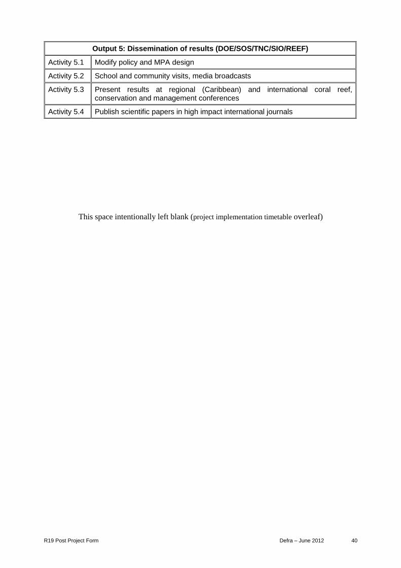
R19 Post Project Form Defra – June 2012 40
Output 5: Dissemination of results (DOE/SOS/TNC/SIO/REEF)
Activity 5.1 Modify policy and MPA design
Activity 5.2 School and community visits, media broadcasts
Activity 5.3 Present results at regional (Caribbean) and international coral reef, conservation and management conferences
Activity 5.4 Publish scientific papers in high impact international journals
This space intentionally left blank (project implementation timetable overleaf)

R19 Post Project Form Defra – June 2012 41
Provide a project implementation timetable that shows the key milestones in project activities. Complete the following table as appropriate to describe the intended workplan for your project.
Activity No of Year 1 Year 2 Year 3
Months (18)
Q1 Q2 Q3 Q4 Q1 Q2 Q3 Q4 Q1 Q2 Q3 Q4
0.0 Steering Group Meetings, Marine Conservation Board Review, Darwin Initiative reporting, progress and evaluation
0.5 • • • •
Output 1 Evidence-based assessment of the response of invasive lionfish to culling
1.1 Detailed planning of field surveys 0.25 •
1.2 Field survey lionfish in culled and control zones by day/dusk 1 • • • •
1.3 Make recommendations on efficacy of culling 0.25 •
Output 2 Protection of multispecies SPA sites
2.1 Monthly field surveys of 6 SPAGs and track larval dispersal 2 • • • •
2.2 Recommendations on SPAG site closure on spatial/temporal/permanent basis
0.5 •
2.3 Mitigate displacement and educate fishers 0.5 •
Output 3 Sustainability of concessions to fishers
3.1 Field survey 53 target fish in 6 fishable area slots between MPAs, in summer and winter
1.5 • •
3.2 Assess overspill and territoriality of species and functional groups 0.25 • •
3.3 Field survey fishers method, catch, & socio-economic background 0.5 • •
3.4 Recommendations on efficacy and management of concessions 0.25 • •
Output 4 Involving public in MPA/Increasing efficiency of enforcement
4.1 Specification of app requirements 0.5 •
4.2 Development of digital interface and codes 2 •
4.3 Development of DOE database 1 •
4.4 Launch of DOE MPA App in public domain, and assessment of interest and effect on assisting enforcement
0.5 • • •
4.5 Development and trial of Enforcement Officer field tablet 2 • •

R19 Post Project Form Defra – June 2012 42
Output 5 Dissemination of results
5.1 Modify policy and MPA design 0.5 • •
5.2 School and community visits, Media broadcasts, 1 • • • • • •
5.3 Present results at regional (Caribbean) and international coral reef, conservation and management conferences
0.5 • •
5.4 Publish scientific papers in high impact international journals 2.5+ after • •

R19 Post Project Form Defra – June 2012 43
Annex 3 Standard Measures
Table 1 Project Standard Output Measures
Code No.
Description Year 1 Total
Year 2 Total
Total to date
Number planned
for reporting
period
Total planned during
the project
1A Number of people to submit thesis for PhD qualification
1 1 1 1 1
1B Number of people to attain PhD qualification
0 0 0 1 1
2 Number of people to attain Masters qualification (MSc, MPhil etc) *
2 4 2 2 7
4A Number of undergraduate students to receive training (case study in Bangor modules)
240 250 240 240 490
4B Number of training weeks to be provided
3 3 3 3 6
4C Number of postgraduate students to receive training (case study, Bangor modules + project students in the field)
25 25 25 25 50
4D Number of training weeks to be provided
2 2 2 2 4
5 Number of people to receive at least one year of training (which does not fall into categories 1-4 above)
2 2 2 2 4
6A Number of people to receive other forms of education/training (which does not fall into categories 1-5 above) * Interns/lionfish culling courses (50-60 every 2 months)
320 330 320 320 650
6B Number of training weeks to be provided
12 12 12 12 24
7 Number of (ie. different types - not volume - of material produced) training
1 0 1 1 1

R19 Post Project Form Defra – June 2012 44
materials to be produced for use by host country
8 Number of weeks to be spent by UK project staff on project work in the host country
60 72 60 60 132
9 Number of species/habitat management plans (or action plans) to be produced for Governments, public authorities, or other implementing agencies in the host country
0 2 0 0 2
10 Number of individual field guides/manuals to be produced to assist work related to species identification, classification and recording
0 1 0 1 1
11A Number of papers to be published in peer reviewed journals
2 4 2 1 6
11B Number of papers to be submitted to peer reviewed journals
1 4 1 1 5
12A Number of computer based databases to be established and handed over to the host country
2 0 2 2 2
12B Number of computer based databases to be enhanced and handed over to the host country
1 0 1 1 1
14A Number of conferences/seminars/ workshops to be organised to present/disseminate findings
1 0 1 1 1
14B Number of conferences/seminars/ workshops attended at which findings from Darwin project work will be presented/ disseminated
4 4 4 4 8

R19 Post Project Form Defra – June 2012 45
15A Number of national press releases in host country(ies)
4 8 4 4 12
17A Number of dissemination networks to be established
1 0 1 1 1
17B Number of dissemination networks to be enhanced/ extended
2 2 2 2 2
18A Number of national TV programmes/features in host country(ies)
11 6 11 11 17
19A Number of national radio interviews/features in host county(ies)
0 2 0 0 2
22 Number of permanent field plots to be established during the project and continued after Darwin funding
has ceased.
62 0 62 62 62
23 Value of resources raised from other sources (ie. in addition to Darwin funding) for project work
304,431* 126,897 304,431 304,431 431,328
*Includes additional grant of £15750 for satellite tagged drifters from Guy Harvey Ocean Foundation, on top of matched funding
Table 2 Publications
Type
Detail
(title, author, year)
Publishers
(name, city)
Available from
(eg contact address, website)
Cost £
Book Chapter
Biology and Ecology of the Coral Reefs of the Cayman Islands John R. Turner et al,(2013) P. 69-88 in C.R.C. Sheppard (ed.), Coral
Reefs of the United Kingdom
Overseas Territories, Coral
Reefs of the World 4, 69 DOI 10.1007/978-94-007-
5965-7_7
Science+Business
Media Dordrecht
2013
http://www.springer.com/environment/aquatic+sciences/book/978-94-007-5964-0
$129

R19 Post Project Form Defra – June 2012 46
Annex 4 Onwards – supplementary material (optional but encouraged as evidence of project achievement)
Annex 4 CV (attached file)
Annex 4: CV Charli Mortimer – Project Support Officer.
Annex 5 Interim Reports (attached files) 1: Egerton, J. (2013) Acoustic Surveys of Grouper Spawning Aggregations in the Cayman Islands. Bangor University. 18p. (Annex 5, Report 1)
2: Worley (2013) Cayman Islands Marine Monitoring Tablet Application Functional Specification Bangor University. (Annex 5, Report 2)
3: McCoy, C., Richardson, L., Mortimer, C (2013) Spawning Aggregations (SPAGs) – “Heading Home” Fish larval dispersal patterns- Cayman Islands. DoE and Bangor University. (Annex 5, Report 3)
4: Sarkis, S (ed). (2013) Lionfish Response Strategy Workshop I: Lionfish response strategy for UK Territories of wider Caribbean Region. Anguilla. 6th February. JNCC. Anguilla. (Annex 5, Report 4)
5: Sarkis, S (ed) (2013) Lionfish Response Strategy Workshop II: Tools to implement research priorities and control measures. DOE, Cayman Islands. 1st & 2nd July, JNCC. (Annex 5, Report 5)
Annex 6 MSc theses (abstracts below)
Balsalobre, M. (2013). The Effect of Caymanian Marine Reserves on Preserving the
Biomass of Fish Assemblages. M.Sc. Thesis, University of Bangor. 59p. The world’s coral reefs’ are currently threatened by the strong pressure that anthropogenic activities exert on these complex ecosystems and by the global ocean warming and acidification, driving the gradual shift from coral to macroalgae dominated reefs. Marine Parks
are called to be one of the major measures to mitigate the deterioration of these stunning ecosystems, and in the Caribbean, where coral reefs are among the most affected around the world, the study of the Marine Parks effectiveness on preserving these ecosystems is vitally important. In this context, the Marine Park network created in the Cayman Islands 26 years ago provides the perfect setting to assess the success of Marine Protected Areas in protecting coral reefs. The present aimed to evaluate this effectiveness by using fish families’ biomass as indicator. Underwater Visual Census using four transects belts were conducted at 24 sites on the island of Grand Cayman and at 16 sites on Little Cayman between July and August 2013. Data collected was examined using univariate and multivariate analyses in order to find differences between Levels of protection (within and outside no-Take Marine Parks), Islands (Grand Cayman and Little Cayman), Depths (shallow and deep terrace on the reef) and Aspects (north, south and west). Mean family biomass measures were significantly different between protection levels and aspect in Grand Cayman, while in Little Cayman significant differences were found between the two terraces of the reef. In both islands, Haemulidae, Lutjanidae, Scaridae and Balistidae accounted for the majority of biomass

R19 Post Project Form Defra – June 2012 47
present on the coral reefs. However, the highly variability and the lack of significant results suggests that specific survey methodologies might be more suitable for obtaining reliable data on each taxa. Beale, P. (2013). Behavioural Responses of Lionfish Towards Divers in Areas of Targeted Catch and No Dive Zones on Grand Cayman. M.Sc. Thesis, University of Bangor.
57p. Invasive species translocations can have severe impacts upon native species and habitats. The Indo-Pacific Lionfish Pterois volitans was released into the Atlantic off Florida in the mid 1908s and has subsequently spread throughout the Caribbean region. In order to control the populations culling initiatives have been set up on Grand Cayman, Caribbean. Although culling effort has been reported to reduce the population, behaviour changes, and increased avoidance behaviour could lead to reduced detectability of Lionfish in culled areas. This study examined the behavioural responses of 67 Lionfish to approaching divers, through underwater surveys. A significant difference in the abundance (P = 0.002) and Size frequencies (P = 0.025) were observed between the Dived Areas and No Dive Zones. Cryptic and Exposed initial behaviours were not significantly different between the DAs and NDZs, (P = 0.852, P = 0.118), and the first response of fish to approaching divers was likewise not significantly different (P = 0.07). Over the course of a 5-minute observation, fish in culled zones demonstrated more defensive behaviour than those of the NDZs (P < 0.001). The length/weight relationship did not differ between Dived Areas and No Dive Zones (P = 0.831). These findings indicate that the culling effort is currently effective as means of population control. Higby, L. (2012). Can a lionfish change its stripes? Investigating the effects of the culling initiative on the behaviour, habitat preference and condition of the invasive lionfish Pterois volitans, on the north coast of Grand Cayman. M.Sc. Thesis, University of Bangor.
80p.
The translocation of species from their native habitats to non-native areas is the subject of much scientific research, due to the potentially negative implications for the invaded ecosystems. The current invasion of the Indo-Pacific lionfish Pterois volitans in the Caribbean Sea is the focus of much current research, due to their alien status, dispersal capabilities and reported negative impacts on the ecosystems of their invaded range. Culling initiatives have been implemented throughout their invaded range, including Grand Cayman, as a means of attempting to control the impacts of invasive lionfish populations on the ecosystems. To date there have been no studies on the potential effects of these culling initiatives on lionfish behaviour and habitat preference. The aim of this study was to determine whether the lionfish culling initiative on the north coast of Grand Cayman, has affected P. volitans abundance and behaviour to SCUBA divers. The numbers and behavioural responses of lionfish in the dived areas (DA), which have been subjected to the pressures of the culling initiative programme, were compared to the lionfish in the no-dive zones (NDZ), which have not been subjected to such pressures. The data suggests that there was a significant difference in P. volitans abundance between the DA and NDZ (P = 0.001), where P. volitans were more abundant in the NDZ compared to the DA, with more encounters in the NDZ than the DA (P = 0.010). However, as solitary lionfish were significantly more likely to exhibit evasive initial behavioural responses and significantly less likely to exhibit aggressive initial behavioural responses towards an approaching SCUBA diver in the DA compared to the NDZ (P = 0.004), this perceived reduction in lionfish abundance could be due to lionfish evading divers before they have even been sighted. No significant difference was found in behaviour when lionfish were encountered as solitary individuals or groups, or whether they were encountered in the DA and NDZ areas. There was also no significant in difference in behaviour with respect to habitat

R19 Post Project Form Defra – June 2012 48
preference and whether the lionfish were encountered on the coral reef wall (W) or reef terrace (T). However, there was a general behavioural trend observed, with lionfish in both the DA and NDZ more likely to be found in habitats classed as concealed and sheltered, compared to being found in exposed habitats. As the data suggests that the culling programme has resulted in lionfish adapting their initial response behaviour towards divers in the DA but not in the NDZ, recommendations for future management strategies is required to minimise the effect of negative interactions with divers, as a result of failed culling attempts. This would include the revision of culling protocol and techniques, to minimise the possibility and regularity of unsuccessful culling attempts and subsequent lionfish behavioural adaptations.
McCarten, CAJ.(2012) Invasive Indo-Pacific lionfish Pterois volitans use of mangrove, sea grass and reef habitats in the Cayman Islands, Caribbean. M.Sc. Thesis, University
of Bangor. 80p. Invasive Indo-Pacific lionfish Pterois volitans have rapidly invaded the western Atlantic and Caribbean and represent a top conservation issue. Their presence in the Cayman Islands has the potential to rapidly impact native reef fish through predation and competition, especially in critical habitats such as nurseries in mangroves and sea grass beds. The present study compares densities, size frequencies, and diet of lionfish in three deep exposed reef habitats and three sheltered shallow water habitats (mangroves, sea grass and lagoon patch reef) over a 3 month period (June-August 2012). Lionfish were observed in all reef habitats but none were observed in either mangrove or sea grass habitats,. Lionfish densities were significantly higher in deep wall habitats, and 4 times greater than the second most abundant habitat (377 ± 89.7- ha and 93.75± 54.1- ha; mean ± SE; p < 0.05) for deep wall and patch reef habitats respectively. Lionfish of sheltered patch reef sites (22.21cm ± 3.33 cm) were significantly smaller than those of the deep terrace (27.78 ± 1.29 cm; p < 0.05) and shallow terrace (30.67 ± 1.17 cm; p < 0.05) reef sites. Lionfish fed over a broad trophic range, with diets composed of 29 species and 14 families, of predominantly teleost fish and some Crustacea. Notably herbivorous fish made up >20% of diets within each habitat. At the deep wall, >50% of the diet was made up of herbivorous fish. Although no lionfish were found in shallow water nursery habitats, the large amounts of herbivorous fish in lionfish stomach contents is of concern. Increased predation on herbivorous fish could lead to a trophic cascade as diversity is already low within the Caribbean compared to it Indo Pacific counterpart.
BSc Thesis (abstract) Warrender, T. (2013). Changing Climates, Changing Reefs: The Effects of the 2009 Mass Coral Bleaching on Grand Cayman Reefs. B.Sc. Thesis, University of Dundee. 61p. Coral reefs are one of the most enriched ecosystems in the world and are currently in a period of global decline due to a combination of natural and anthropogenic factors. In light of rising sea surface temperatures, corals will be subjected to physiological stress causing increased incidences of bleaching. Grand Cayman is one of three isolated islands in the north-west Caribbean and despite having relatively low anthropogenic impact, it lies in a hurricane zone which is vulnerable to frequent storm events. This study aims to document the state of Grand Cayman coral reefs after a severe mass bleaching in 2009. Video analysis was conducted along transect belts, surveying benthos at 18 sites around Grand Cayman, between June and August 2013. Using statistical analysis in R, community composition and individual species abundances were compared with explanatory variables year (2011/2013), depth (deep/shallow), aspect (west/north/south) and protection (inside/outside MPAs). Coral cover only increased by 1% between 2011 and 2013 (10–11%). On all aspects and depths an algal phase shift had progressed over the two year period (37–65% increase in macroalgae) and

R19 Post Project Form Defra – June 2012 49
the amount of dead coral with algae had considerably decreased (26–7%), indicating macroalgae have colonized the dead coral. The lowest coral cover was found on the south of the island, the most exposed aspect and interestingly different algal species showed higher abundance according to different aspects. This experiment allows permanent data from which future replicate studies can be conducted
Annex 7 Presentations
ABSTRACTS OF PAPERS, CONFERENCE PRESENTATIONS, PROCEEDINGS, not captured above
Book Chapter Published:
Turner, J.R., McCoy, C., Cottam, M, Olynik,J., Austin, T, Blumenthal,J. Bothwell, J., Burton, F.J., Bush, P., Chin, P., Dubock, O., Godbeer, K.D., Gibb, J., Hurlston, L., Johnson, B.J., Longan, A., Parsons, G., Ebanks-Petrie, G. (2013). Biology and ecology of the coral reefs of the Cayman Islands. Chapter 7, P. 69-88 in Sheppard, C.R.C., (ed). Coral reefs of the United Kingdom Overseas Territories. No.4 Coral Reefs of the World. Springer.) (attached file
Paper submitted: Higby, L.K., Stafford, R., McCoy, C., Turner, J.R. Behavioural consequences of culling programmes on invasive lionfish (Pterois volitans) in Grand Cayman. Journal of Experimental Marine Biology and Ecology. Lionfish are an invasive species in much of the tropical western Atlantic Ocean. To help reduce lionfish populations, culling initiatives have been implemented; mainly through the use of hand spears by volunteer divers. This study examines interactions between lionfish abundance and behaviour in a dived area and a diving restricted area of Grand Cayman (where lionfish have been subject to culling or attempted culling only in the dived area). The encounter rate and abundance of lionfish was lower in the dived area, but the lionfish also demonstrated more evasive behaviour when they encountered divers. The behavioural change may arise from unsuccessful culling attempts. The behavioural change may lead to overestimating the effects of culling on the population, and may also make lionfish more difficult to cull subsequently. Initiatives to improve culling training provided to divers need to be implemented to ensure effective population control in the future.
Lionfish strategy workshops:
Bradley Johnson DoE took part in a ICRI Workshop organized by the Regional Lionfish Committee (RLC): Lionfish, invasive exotic species: Management and Control Mérida, Yucatán, Mexico, 11 October 2013 (as part of the 1st Pan-American Congress on coral reefs)
DoE also hosted the JNCC Lionfish Response Strategy Workshop II, Cayman Islands, July 2013.
Presentations made to date:
Richardson, L.; McCoy, C; Ebanks-Petrie, G.; Austin, T.; Olynik, J.; Byrne, J.; Turner, J. (2013). Cayman Islands Marine Protected Areas, enhancing a 27 year legacy. Gulf and

R19 Post Project Form Defra – June 2012 50
Caribbean Fisheries Institute (GCFI) 66th Meeting, 4th-8th November, Corpus Christi, Texas, USA. Conference oral presentation: Marine Protected Areas may be a viable solution for survival of coral reef communities, providing refugia from overfishing and habitat degradation, increasing resilience against stressors from invasive species and climate change. MPAs are predicted to benefit adjacent areas by larval export and net migration. The Cayman Islands Department of Environment, in collaboration with Bangor University, Wales and The Nature Conservancy, through a three-year Darwin Initiative project has conducted a detailed review of the current Marine Protected Areas of the Cayman Islands to determine whether they are optimal in size and area, appropriately located, and provide maximum resilience in the face of present day threats. Established in 1986, the no-take areas are distributed around each island, covering approximately 14% of Cayman’s shallow shelf. MPA performance has been assessed at 62 sites around all three Islands on standard reef health parameters. Results suggest that MPAs maintain a degree of reef resiliency in Cayman. However, the Islands have experienced declines in reef health reflecting regional trends, notably extensive hard-coral mortality, substantial loss of acroporid branching corals and key grazer Diadema antillarum, and changes in reef fish communities. In order to address present day local and regional threats, a comprehensive process of MPA enhancement planning was undertaken which incorporated a locally defined Marine Ecological Gap Analysis (including creation of an Environmental Risk Surface, identification of conservation targets, and generation of optimum conservation model outputs using Marxan), socio-economic/biological decision support tools, extensive stakeholder liaison and consideration of internationally recommended best practices for MPA network design.
Richardson, L.; McCoy, C.; Turner, J. (2013). Estimating marine reserve effects through quantification of macro-algal biomass, Cayman Islands. Gulf and Caribbean Fisheries Institute (GCFI) 66th Meeting, 4th-8th November, Corpus Christi, Texas, USA. Conference poster presentation Marine protected areas (MPAs) are widely considered to aid resiliency to hard-coral/macroalgal phase shifts. To determine the effectiveness of an established marine reserve in Grand Cayman, algal biomass was compared within and outside the reserve. Between November-December 2010, macroalgae was extracted from five 0.25m2 quadrats at 12 shallow reef sites at an 8-10m depth (4 sites MPA, 8 non-MPA), samples identified to genus and weighed to attain mean biomass measures per site. A total dry-weight of 544.45g was collected (mean biomass at sites ranged from 3.47-6.26g West-MPA; 3.80-5.90g North-non-MPA; and 6.82-26.05g South-non-MPA), with Dyctiota, Halimeda, Lobophora, filamentous turf algae and other turfing algae comprising total biomass at most sites. Reserve effect was not detected (P>0.05), though variability between sites based on aspect differentials were observed. Biomass was significantly higher in the South than North and West (P<0.05), which exhibited similar biomass values (P>0.05). Species composition varied between sites with southern sites displaying a significantly different algal community structure (P<0.05), driven by comparatively minimal biomass of Lobophora, consistently large proportion of Halimeda and a greater biomass of turf algae than the North and West. Differences in biomass around the island may indicate natural variation between reefs of different exposures determining habitat complexity, reef fish populations, nutrient levels and available spores for algal recruitment. Intra-habitat variation may be responsible for concealing reserve effect in the West. Similarly, algae around the island may have reached a ‘size refuge’ whereby keystone herbivores no longer graze upon them and thus minimal ‘effect’ would be evident.

R19 Post Project Form Defra – June 2012 51
Richardson, L.; Meier, R.; McCoy, C.; Turner, J. (2013). Impacts of recreational and artisanal fisheries, Cayman Islands, Caribbean. Gulf and Caribbean Fisheries Institute (GCFI) 66th Meeting, 4th-8th November, Corpus Christi, Texas, USA. Conference poster presentation. To examine the potential impact of recreational and artisanal fisheries on reef ecosystems in the Cayman Islands (where there is no commercial fishing), the level of fishing pressure was investigated by using structured questionnaires directed at fishers. Illegal fishing pressure was investigated using marine enforcement officer reports spanning 1993-2010. Within a monthly period, fishers reported catching 14,968 fish on Grand Cayman and 5205 fish on the Sister Islands (88% and 80% of which were reef fish, respectively). The mean catch size was 72 (±SD 152) fish month-1 on Grand Cayman, and catch size was significantly higher for respondents targeting reef fish than for those targeting pelagic species (Mann-Whitney U test, P <0.01). The mean number of days spent fishing month-1 ranged between 5.1 (±SD 6.5) and 8.4 (±SD 7.4). While Lutjanids were caught in greatest numbers, of greatest concern were the numbers of herbivores extracted. Fishing effort was non-uniformly distributed around the islands (Chi-square tests, P <0.01) being aligned closely with fringe reefs, populated areas and shore access points. Poaching in the MPAs and other illegal fishing activities remain an issue, with the queen conch (Strombus gigas) representing the major target organism. Despite major support for the idea of marine environmental management, over 50% of interviewed fishers believed that enforcement of marine park laws is currently inadequate. The impacts of artisanal and recreational fishing is often overlooked; this study indicates that both practices are significant in the Cayman Islands, with the potential to influence reef resilience and ecosystem functioning.
McCoy, C; Meier, R; Turner, J. (2013) Quantifying the Impact of Recreational and Artisanal Fisheries in the Cayman Islands through the use of Socio-Economic Questionnaires. 43rd Benthic Ecology Meeting (2014), University of North Florida, Jacksonville, Florida. Conference poster presentation. To examine the impact of recreational and artisanal fisheries in the Cayman Islands (where there is no commercial fishing), the level of fishing pressure was investigated. Structured questionnaires were directed at fishers on Grand Cayman, Cayman Brac and Little Cayman, during February and March 2011. Catch size, target species, fishing effort and the spatial distribution of fishing activities were documented. Within a monthly period, fishers reported catching a total of 14,968 fish on Grand Cayman, 4424 on Cayman Brac and 781 on Little Cayman. Mean catch size was 72 (±SD 152) fish month-1 on Grand Cayman, and catch size was significantly higher for respondents targeting reef fish than for those targeting pelagic species (Mann-Whitney U test, P<0.01). The mean number of days spent fishing month-1 ranged between 5.1 (±SD 6.5) and 8.4 (±SD 7.4), and of the fish caught, Lutjanids were targeted in greatest numbers on the three islands. Fishing effort was non-uniformly distributed around the islands and was fairly restricted to key areas. This study provides a step toward determining the level of fishing pressure on reef ecosystems from non-commercial fisheries and indicates that both practices are significant in the Cayman Islands. Accepted abstracts for oral presentations in the next reporting period: Austin, T, Turner, J. McCoy, C, Richardson, L. Byrne, J., Ebanks Petrie, G. Darwin Initiative to enhance an established marine protected area system in the Cayman Islands. International Marine Conservation Congress, Glasgow, Scotland 14-18th August 2014. Oral Presentation.

R19 Post Project Form Defra – June 2012 52
The project reviewed a 25 year legacy of MPAs in the Cayman Islands in maintaining resilience of coastal ecosystems in response to direct human impact and climate change. The aim was to redesign the system to be ‘fit for purpose’ for a further 25 years. Key outcomes: (1) Assessment of resilience: reef health measured at 62 permanently established monitoring sites inside and outside of MPA system showed that MPAs provide local resilience (higher coral cover and recruitment; lower coral bleaching, disease prevalence and algal cover). (2) Assessment of benefit: overspill of fish into surrounding waters was evident at some MPA boundaries, and number, size and biomass of 53 target fish species were greater in MPAs than outside. However, invasive lionfish threaten fish communities. (3) Assessment of fisheries impact: recreational, artisanal and illegal fishing are significant on Cayman reefs, and fishers exploit MPA boundaries. Understanding the incentives to fish legally and illegally were included in MPA design. (4) Stakeholder consultation, ecological survey and protected area planning tools were used to plan an enhanced MPA system which increases No-Take protection from 15 to 47% of the shelf. A campaign of public awareness, education and consultation is maximising support for the new MPA system. MPAs are a viable solution for survival of coral reef communities, providing refugia from overfishing, habitat fragmentation, and increasing resilience against stressors from invasive species and climate change. McCoy, C., Turner, J., EBanks Petrie, E., Austin, T, Byrne, J., Richardson, L. Measuring MPA performance, “Fit or Unfit for purpose; an evaluation of Caymanian MPAs after 26 years on target reef fish assemblages. International Marine Conservation Congress, Glasgow, Scotland 14-18th August 2014. Oral Presentation.
For decades, scientific studies in the Cayman Islands, located in the remote north-west Caribbean have focused on their benthic communities, not on their reef fish assemblages. Due to its small insular shelf area, landmass and remoteness, to date there are no commercial fisheries in this small British overseas territory. In 1986, Marine Protected Areas (MPAs) were established by the Cayman Government, with the main objective of protecting coral reefs and their associated organisms from the emerging Scuba diving and tourism industry. In this 4 year study (2009-2012), populations of important fish species for reef health function and species most commonly targeted by recreational fishers have been compared between protected areas and non-protected fished areas across the three islands of Grand Cayman, Cayman Brac and Little Cayman during the months of January to April. For 48 target species, biomass, size and density were compared between MPA sites and non-MPA sites. Additionally, the relationships between the different trophic groups were explored. The exportation of individuals by spillover effects were measured at each MPA boundary using linear regression of the mean biomass per site over distance from the MPAs. Reserve effect on fish was evaluated for the first time for each island after more than two decades of protection. Spillover effect was only evident in Grand Cayman, suggesting that MPA size and adjacent habitat play a role in migration of fish out of MPAs. Jeremy Olnik, DoE GIS officer will attend the Esri International User Conference in San Diego, California, from July 14-18, 2014 to take part in workshops and skills training. http://www.esri.com/events/user-conference
Events: 24.01.2014 DoE Presentation: Darwin Initiative Post Project Launch DoE Press Briefing: ‘New Research and Innovative App Solutions, with Marine Parks Revisited’

R19 Post Project Form Defra – June 2012 53
The Darwin Initiative project from 2010-2013 set out to comprehensively review the existing Marine Parks and design an enhanced system as necessary to allow the Cayman Islands Government to ensure that the Parks remain appropriately configured to provide adequate protection to Cayman’s marine habitats and resources for current and future generations. These proposals have been out for a comprehensive round of public consultation and are currently under consideration by the new Cabinet. Following on from the first project, additional Darwin ‘Post-project’ funding has been acquired to address four key issues that have been identified as having the potential to undermine the success of the enhanced or existing Marine Parks network: (1) The invasive lionfish, (2) the use and management of Cayman’s multi-species spawning aggregations, (3) the extent of fish overspill from Marine Parks into concessionary fishing areas, and finally (4) limited enforcement capacity. This Post-project is underway with innovative research being done on the lionfish, some exciting assessments being done on the country’s SPAGs, work proposed for socio-economic fisher surveys this summer, and the DOE’s first suite of smart phone and tablet applications to be launched this year as novel solutions to improve enforcement capacity and efficiency whilst engaging and empowering the public! The briefing can be watched here: http://www.youtube.com/watch?v=8JeBh9MO4gA (lasts one hour)
15.05.14 DoE District Event on Little Cayman

R19 Post Project Form Defra – June 2012 54
Checklist for submission
Check
Is the report less than 10MB? If so, please email to [email protected] putting the project number in the Subject line.
Yes
Is your report more than 10MB? If so, please discuss with [email protected] about the best way to deliver the report, putting the project number in the Subject line.
No
Have you included means of verification? You need not submit every project document, but the main outputs and a selection of the others would strengthen the report.
Yes
Do you have hard copies of material you want to submit with the report? If so, please make this clear in the covering email and ensure all material is marked with the project number.
No
Have you involved your partners in preparation of the report and named the main contributors
Yes
Have you completed the Project Expenditure table fully? Yes
Do not include claim forms or other communications with this report.