Dane County Vandewalle & Associates Strand Associates William O’Connor
23
10/02/02 Dane County Vandewalle & Associates Strand Associates William O’Connor Possible Recommended Roadway Component
description
Dane County Vandewalle & Associates Strand Associates William O’Connor. Possible Recommended Roadway Component. Roadway Concepts. Low Speed Locally Oriented Parkway. Moderate Speed Inter Community Oriented Parkway. High Speed Regional Parkway. Mobility. 19. Land Access. 113. River. - PowerPoint PPT Presentation
Transcript of Dane County Vandewalle & Associates Strand Associates William O’Connor

10/02/02
Dane County
Vandewalle & Associates
Strand Associates
William O’Connor Possible Recommended
Roadway Component

10/02/02
Roadway Concepts
Low Speed Locally Oriented Parkway
Moderate Speed Inter Community Oriented Parkway
High Speed Regional Parkway

10/02/02
Low Speed Locally Oriented Parkway
113
19
K
M
1290/94
OnckenBalzer
Fisher
Meffert
Woodland Bong
Q
Riv
er
Phea
sant
Bra
nch
Woo
dlaw
n
Hig
h R
d
Possible 4-ln Improvement
• Constructs a Low Speed (35 mph) Corridor Oriented to Land Access
• Maps a higher speed corridor to satisfy future transportation needs
Mobility
Land Access

10/02/02
Ultimate Low Speed Locally Oriented Parkway Cross Section
Lane Lane
Bike Lane
TerraceMulti Use Path
Sidewalk
Lane Lane
Bike Lane
Terrace Median
Keep Existing Half-Boulevard Roadway
And Implement Boulevard by Adding Other Lanes

10/02/02
Paved Shoulders
Initial Low Speed Locally Oriented Parkway Cross Section

10/02/02
Moderate Speed Inter-Community Oriented Parkway
113
19
K
M
1290/94
OnckenBalzer
Fisher
Meffert
Woodland Bong
Q
Riv
er
Phea
sant
Bra
nchGreenbriar
Woo
dlaw
n
Hig
h R
d
• Constructs a Moderate Speed (45 mph) Corridor Oriented to Regional Movement
Mobility
Land Access

10/02/02
Ultimate Moderate Speed Inter-Community Parkway Cross Section
Lane Lane
Bike Lane
TerraceMulti Use Path
Sidewalk
Lane Lane
Bike Lane
Terrace Median
Keep Existing Half-Boulevard Roadway
And Implement Boulevard by Adding Other Lanes

10/02/02
Paved Shoulders
Initial Moderate Speed Inter Community Oriented Parkway Cross Section

10/02/02
High Speed Regional Parkway
113
19
K
M
1290/94
OnckenBalzer
Fisher
Meffert
Woodland Bong
Q
Riv
er
Phea
sant
Bra
nch
Woo
dlaw
n
Hig
h R
d
• Constructs a High Speed (55 mph) Corridor Oriented to Regional Movement
Mobility
Land Access
10/02/02
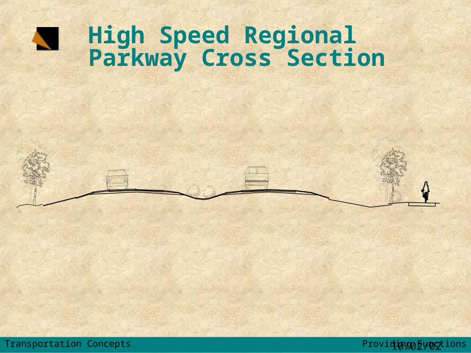
High Speed Regional Parkway Cross Section
Transportation Concepts Providing Functions

10/02/02
Alignment Locations

10/02/02
• 35 mph Design Speed• Primary Function - Access to
SubdivisionsImpacts:• 306 acres R/W (135 acres net)
– 98 acres Farmland– 29 acres Wetland/floodplain/env corridor– 171 acres existing R/W– 8 acres other
Mobility
Land Access
Low Speed Locally Oriented Parkway

10/02/02
• 45 mph Design Speed
• Primary Function - Inter-Community traffic movements
• 307 acres R/W (125 acres net)– 82 acres Farmland– 34 acres Wetland/floodplain/env corridor– 182 acres existing R/W– 9 acres other
Mobility
Land Access
Moderate Speed Inter-Community Oriented Parkway

10/02/02
• 60 mph Design Speed
• Primary Function - Inter-regional traffic movement
Impacts:
• 484 acres R/W (236 acres net)– 165 acres Farmland
– 50 acres Wetland/floodplain/env corridor
– 248 acres R/W
– 21 acres other
Mobility
Land Access
High Speed Regional Parkway

10/02/02
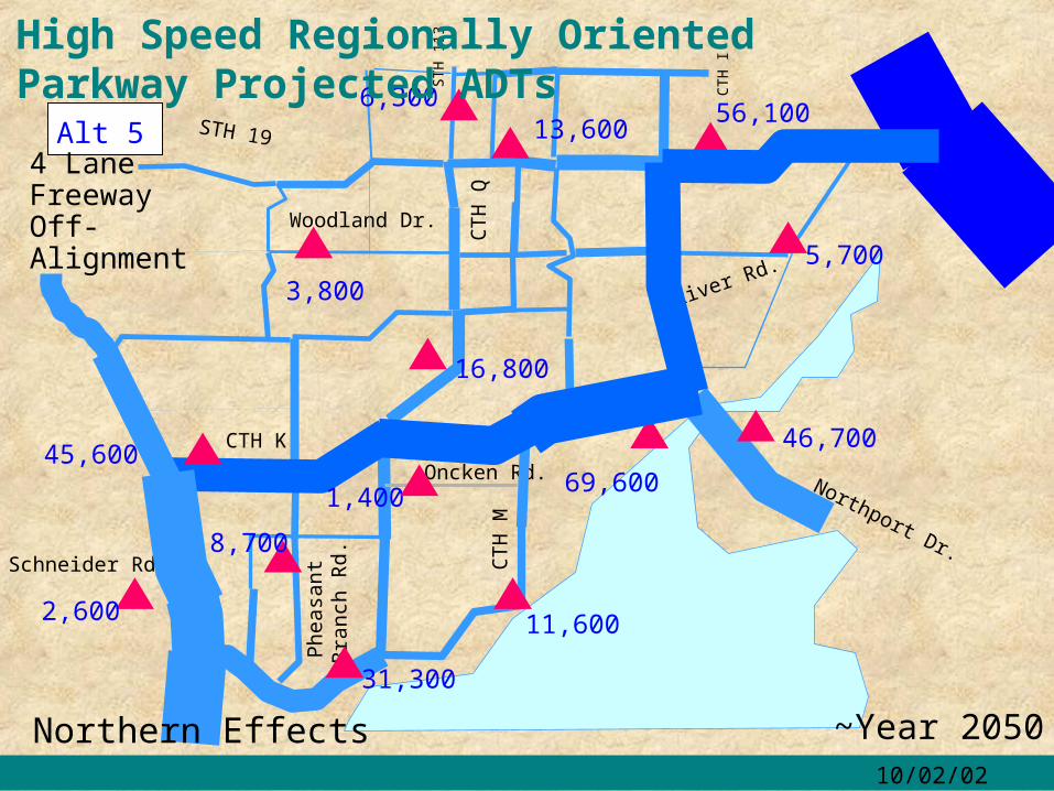
39,000Oncken Rd.
ST
H 1
13C
TH
Q
CT
H M
STH 19
Northport Dr.
Phe
asa
nt
Bra
nch
Rd.
CTH K
Woodland Dr.
Riv
er R
d.
CT
H I
Schneider Rd.
Low Speed Locally Oriented Parkway Projected ADTs
~Year 2050
14,600
28,800
8,400
2,200
18,900
5,100
4,200
8,200
5,000
12,500
13,800
32,300
Alt 3
44,500
Onken-Balzer Connection
35 mph Neighborhood Oriented
6,900

10/02/02
42,900Oncken Rd.
ST
H 1
13C
TH
Q
CT
H M
STH 19
Northport Dr.
Phe
asa
nt
Bra
nch
Rd.
CTH K
Woodland Dr.
Riv
er R
d.
CT
H I
Schneider Rd.
~Year 2050
12,600
29,200
10,000
8,2002,200
23,700
5,500
6,600
7,300
3,000
12,800
13,800
30,300
Alt 3
45,400
Onken-Balzer Connection
Moderate Speed Inter-Community Oriented Parkway Projected ADTs
10/02/02
69,600Oncken Rd.
ST
H 1
13
CT
H Q
CT
H M
STH 19
Northport Dr.
Phe
asa
nt
Bra
nch
Rd.
CTH K
Woodland Dr.
River Rd.
CT
H I
Schneider Rd.
Alt 5
~Year 2050
4 Lane Freeway Off-Alignment
46,700
31,300
16,800
5,700
8,700
2,600
1,400
3,800
6,300
11,600
13,600
45,600
56,100
Northern Effects
High Speed Regionally Oriented Parkway Projected ADTs

10/02/02
Focus Corridor Volume
01000020000300004000050000600007000080000
ADT
Low BuildLow Speed Locally Oriented ParkwayModerate Speed Regionally Oriented ParkwayHigh Speed Regionally Oriented Parkway

10/02/02
Select Link AnalysisAlternative 3
Onken Balzer Connection Land Use Scenario 1
CTH M (STH 113 to CTH K)West to East - Normalized to Percentage
~2050
16%
38%
13% 28%
60%
20%
12%
Low Speed Locally Oriented and
Moderate Speed Inter-Community Oriented Parkway

10/02/02
Select Link AnalysisAlternative 5
4-Lane Freeway Off-Alignment Land Use Scenario 1
CTH M (STH 113 to CTH K)West to East - Normalized to Percentage
~2050
65%
8% 53%
47%
17%
11%
34%9%
High Speed Regionally Oriented Parkway
Greater capacity, before it is needed, draws traffic from further distances
Greater capacity, before it is needed, draws traffic from further distances

10/02/02
Comparison
Low-SpeedLocally
Oriented Parkway
Moderate-Speed Inter-Community
Oriented Parkway
High Speed Regional Parkway
Traffic Served Local Inter-Community Regional
Design Speed 35 mph 45 mph 60 mph
CTH M Vol 39,000 42,900 69,600(East of CTH K)

10/02/02
ComparisonLow-Speed
Locally Oriented Parkway
Moderate-Speed Inter-Community
Oriented Parkway
High Speed Regional Parkway
R/W 318 ac 312 ac 484 ac
Phase 1 Const Cost ~2.5 mil ~2.0 mil ----
Phase 2 Const Cost 28 mil 28 mil 46 mil
Funding Local
Local/ County with
jurisdictional transfer
State with locally
supported alignment

10/02/02
Dane County
Vandewalle & Associates
Strand Associates
William O’Connor Possible Recommended
Roadway Component