CycleStreets - Opportunities for local authorities
16
CycleStreets is the UK-wide cycle journey planner, offering a user-friendly way for people to plan cycle-friendly routes from A-B online or on their mobile. Link to CycleStreets today or commission a customised journey planner for your website. ACT Travelwise Awards Services and opportunities for Local Authorities HELPING MORE PEOPLE CYCLE, MORE SAFELY, MORE OFTEN CycleStreets UK-WIDE CYCLE JOURNEY PLANNER
Transcript of CycleStreets - Opportunities for local authorities
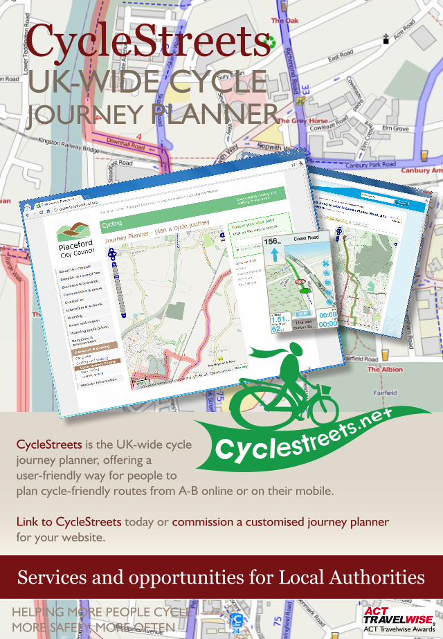
CycleStreets is the UK-wide cycle journey planner, offering a user-friendly way for people to plan cycle-friendly routes from A-B online or on their mobile.
Link to CycleStreets today or commission a customised journey planner for your website.
ACT Travelwise Awards
Services and opportunities for Local Authorities
HELPING MORE PEOPLE CYCLE,MORE SAFELY, MORE OFTEN
CycleStreets UK-WIDE CYCLE JOURNEY PLANNER
2
Planning a cycle route with CycleStreets
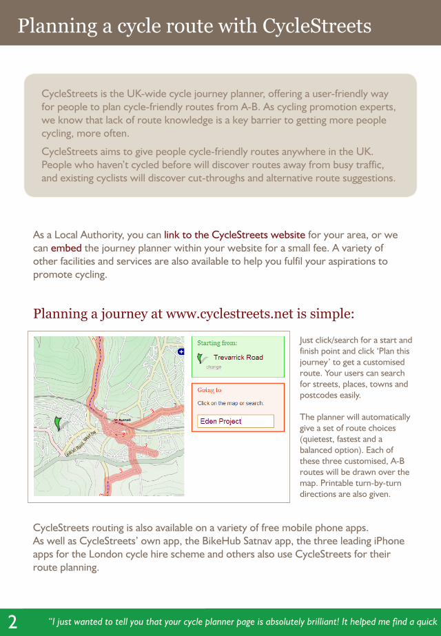
CycleStreets is the UK-wide cycle journey planner, offering a user-friendly way for people to plan cycle-friendly routes from A-B. As cycling promotion experts, we know that lack of route knowledge is a key barrier to getting more people cycling, more often.
CycleStreets aims to give people cycle-friendly routes anywhere in the UK. People who haven’t cycled before will discover routes away from busy traffic, and existing cyclists will discover cut-throughs and alternative route suggestions.
As a Local Authority, you can link to the CycleStreets website for your area, or we can embed the journey planner within your website for a small fee. A variety of other facilities and services are also available to help you fulfil your aspirations to promote cycling.
Planning a journey at www.cyclestreets.net is simple:
Just click/search for a start and finish point and click ‘Plan this journey’ to get a customised route. Your users can search for streets, places, towns and postcodes easily.
The planner will automatically give a set of route choices (quietest, fastest and a balanced option). Each of these three customised, A-B routes will be drawn over the map. Printable turn-by-turn directions are also given.
CycleStreets routing is also available on a variety of free mobile phone apps. As well as CycleStreets’ own app, the BikeHub Satnav app, the three leading iPhone apps for the London cycle hire scheme and others also use CycleStreets for their route planning.
“I just wanted to tell you that your cycle planner page is absolutely brilliant! It helped me find a quick route from my house to my new job. Very much appreciated, well done.”
3
Route display
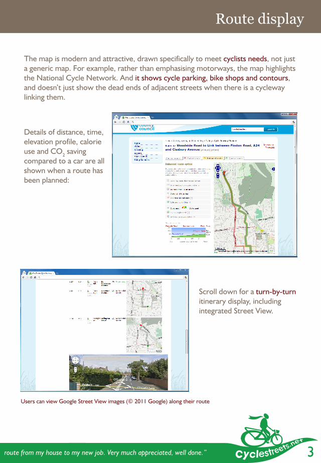
The map is modern and attractive, drawn specifically to meet cyclists needs, not just a generic map. For example, rather than emphasising motorways, the map highlights the National Cycle Network. And it shows cycle parking, bike shops and contours, and doesn’t just show the dead ends of adjacent streets when there is a cycleway linking them.
Scroll down for a turn-by-turn itinerary display, including integrated Street View.
Users can view Google Street View images (© 2011 Google) along their route
“I just wanted to tell you that your cycle planner page is absolutely brilliant! It helped me find a quick route from my house to my new job. Very much appreciated, well done.”
Details of distance, time, elevation profile, calorie use and CO2 saving compared to a car are all shown when a route has been planned:
4
Helping get people cycling Mobile phone versions
We’ve tried to make it as easy as possible for people to find cycle-friendly routes. These and other many other features are listed at www.cyclestreets.net/features .
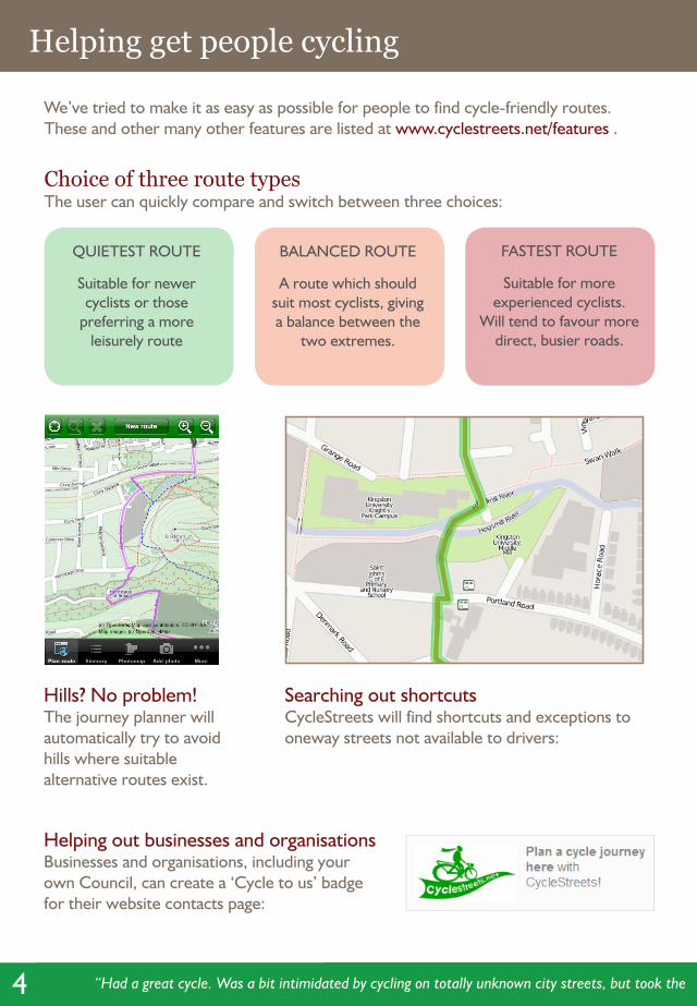
Choice of three route typesThe user can quickly compare and switch between three choices:
QUIETEST ROUTE
Suitable for newer cyclists or those
preferring a more leisurely route
BALANCED ROUTE
A route which should suit most cyclists, giving a balance between the
two extremes.
FASTEST ROUTE
Suitable for more experienced cyclists.
Will tend to favour more direct, busier roads.
Helping out businesses and organisationsBusinesses and organisations, including your own Council, can create a ‘Cycle to us’ badge for their website contacts page:
Hills? No problem!The journey planner will automatically try to avoid hills where suitable alternative routes exist.
“Had a great cycle. Was a bit intimidated by cycling on totally unknown city streets, but took the ‘fastest’ route, which included a lovely cycle through Kelvingrove.”
Searching out shortcutsCycleStreets will find shortcuts and exceptions to oneway streets not available to drivers:
5
Helping get people cycling Mobile phone versions
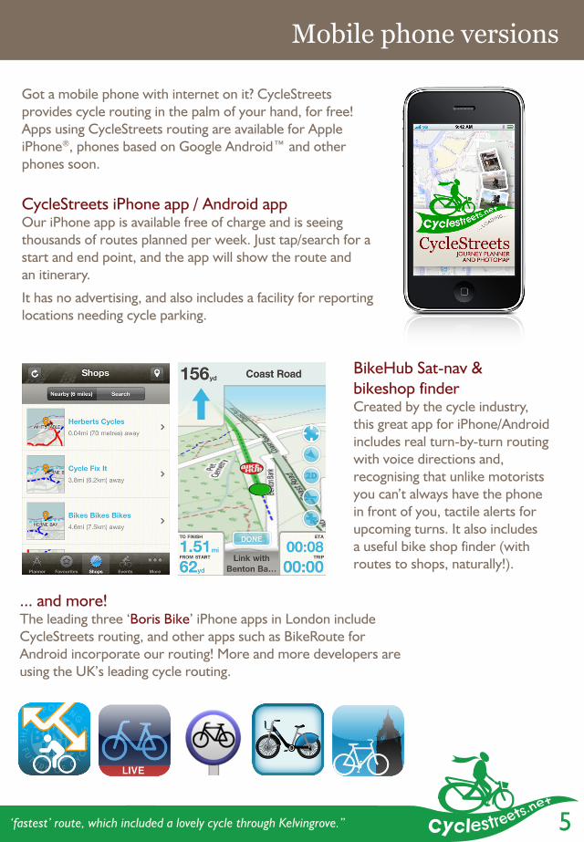
Got a mobile phone with internet on it? CycleStreets provides cycle routing in the palm of your hand, for free!Apps using CycleStreets routing are available for Apple iPhone®, phones based on Google Android™ and other phones soon.
CycleStreets iPhone app / Android appOur iPhone app is available free of charge and is seeing thousands of routes planned per week. Just tap/search for a start and end point, and the app will show the route and an itinerary.
It has no advertising, and also includes a facility for reporting locations needing cycle parking.
BikeHub Sat-nav & bikeshop finderCreated by the cycle industry, this great app for iPhone/Android includes real turn-by-turn routing with voice directions and, recognising that unlike motorists you can’t always have the phone in front of you, tactile alerts for upcoming turns. It also includes a useful bike shop finder (with routes to shops, naturally!).
... and more!The leading three ‘Boris Bike’ iPhone apps in London include CycleStreets routing, and other apps such as BikeRoute for Android incorporate our routing! More and more developers are using the UK’s leading cycle routing.
“Had a great cycle. Was a bit intimidated by cycling on totally unknown city streets, but took the ‘fastest’ route, which included a lovely cycle through Kelvingrove.”
6
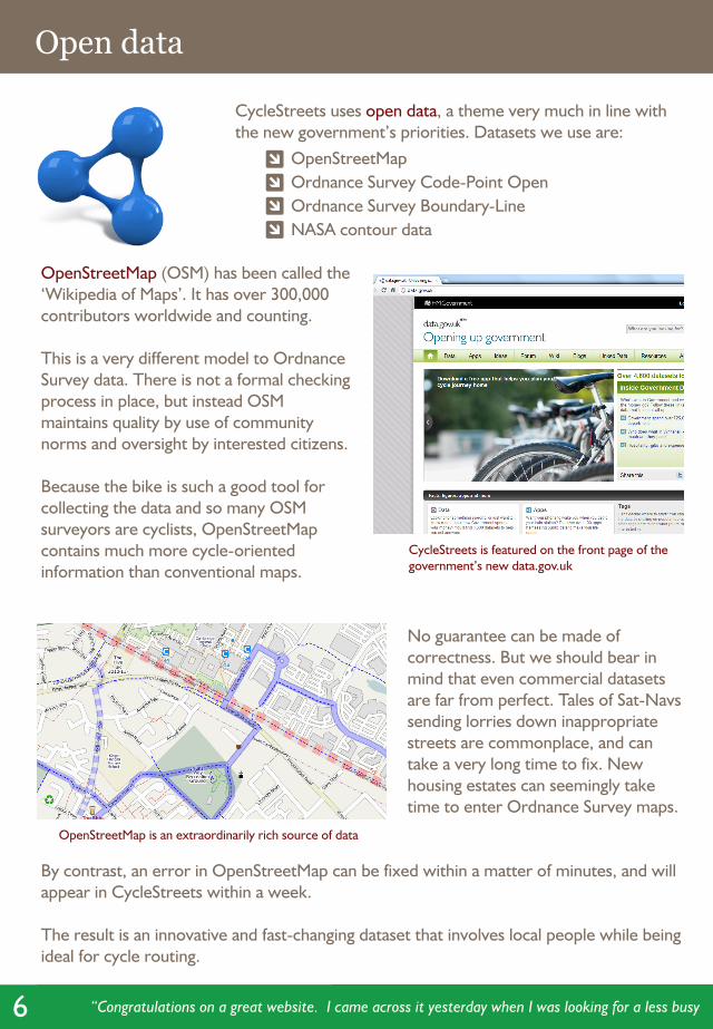
OpenStreetMap (OSM) has been called the ‘Wikipedia of Maps’. It has over 300,000 contributors worldwide and counting.
This is a very different model to Ordnance Survey data. There is not a formal checking process in place, but instead OSM maintains quality by use of community norms and oversight by interested citizens.
Because the bike is such a good tool for collecting the data and so many OSM surveyors are cyclists, OpenStreetMap contains much more cycle-oriented information than conventional maps.
No guarantee can be made of correctness. But we should bear in mind that even commercial datasets are far from perfect. Tales of Sat-Navs sending lorries down inappropriate streets are commonplace, and can take a very long time to fix. New housing estates can seemingly take time to enter Ordnance Survey maps.
By contrast, an error in OpenStreetMap can be fixed within a matter of minutes, and will appear in CycleStreets within a week.
The result is an innovative and fast-changing dataset that involves local people while being ideal for cycle routing.
Open data
CycleStreets uses open data, a theme very much in line with the new government’s priorities. Datasets we use are: OpenStreetMap Ordnance Survey Code-Point Open Ordnance Survey Boundary-Line NASA contour data
“Congratulations on a great website. I came across it yesterday when I was looking for a less busy route for my commute to work. The elevation profile is especially useful.”
CycleStreets is featured on the front page of the government’s new data.gov.uk
OpenStreetMap is an extraordinarily rich source of data
7
A Big Society project
Big Society - compliantCycleStreets is a great example of a true‘Big Society’-style project:
Citizen involvement: combines skills and input of large numbers of people (collecting data).
High quality service: CycleStreets is arguably the most popular and most user-friendly UK-wide cycle journey planner.
Innovative: leading the way with new ideas, rapid innovation, and ever-higher quality routing.
Open Data: uses open data throughout – including government data.
Low cost: the system has been developed without millions of pounds of government money. CycleStreets is operated on a not-for-profit basis.
Trusted: for the people, by the people.
Transparency: more people oversee the data and spot problems or potential improvements.
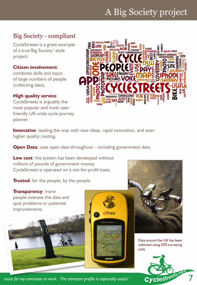
Data around the UK has been collected using GPS surveying units
“Congratulations on a great website. I came across it yesterday when I was looking for a less busy route for my commute to work. The elevation profile is especially useful.”
8
Journey planner solutions for Local Authorities
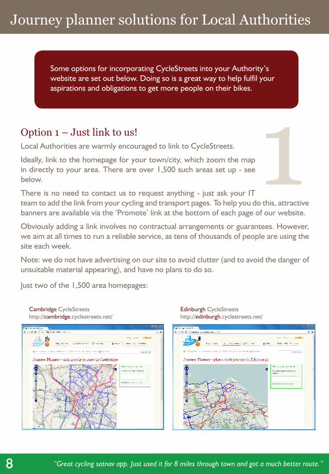
Option 1 – Just link to us!Local Authorities are warmly encouraged to link to CycleStreets.
Ideally, link to the homepage for your town/city, which zoom the map in directly to your area. There are over 1,500 such areas set up - see below.
There is no need to contact us to request anything - just ask your IT team to add the link from your cycling and transport pages. To help you do this, attractive banners are available via the ‘Promote’ link at the bottom of each page of our website.
Obviously adding a link involves no contractual arrangements or guarantees. However, we aim at all times to run a reliable service, as tens of thousands of people are using the site each week.
Note: we do not have advertising on our site to avoid clutter (and to avoid the danger of unsuitable material appearing), and have no plans to do so.
Just two of the 1,500 area homepages:
Some options for incorporating CycleStreets into your Authority’s website are set out below. Doing so is a great way to help fulfil your aspirations and obligations to get more people on their bikes.
Cambridge CycleStreetshttp://cambridge.cyclestreets.net/
Edinburgh CycleStreetshttp://edinburgh.cyclestreets.net/
1
“Great cycling satnav app. Just used it for 8 miles through town and got a much better route.” – A user of the BikeHub app, which uses CycleStreets routing
9
Journey planner solutions for Local Authorities
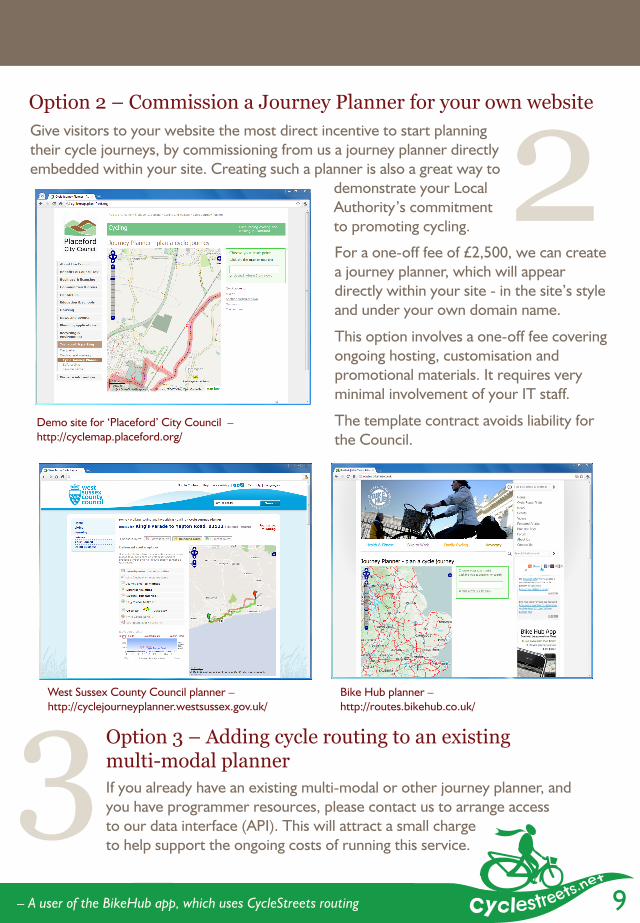
Option 2 – Commission a Journey Planner for your own website
Demo site for ‘Placeford’ City Council –http://cyclemap.placeford.org/
For a one-off fee of £2,500, we can create a journey planner, which will appear directly within your site - in the site’s style and under your own domain name.
This option involves a one-off fee covering ongoing hosting, customisation and promotional materials. It requires very minimal involvement of your IT staff.
The template contract avoids liability for the Council.
West Sussex County Council planner –http://cyclejourneyplanner.westsussex.gov.uk/
Bike Hub planner – http://routes.bikehub.co.uk/
Give visitors to your website the most direct incentive to start planning their cycle journeys, by commissioning from us a journey planner directly embedded within your site. Creating such a planner is also a great way to
demonstrate your Local Authority’s commitment to promoting cycling.
Option 3 – Adding cycle routing to an existing multi-modal plannerIf you already have an existing multi-modal or other journey planner, and you have programmer resources, please contact us to arrange access to our data interface (API). This will attract a small charge to help support the ongoing costs of running this service.
2
3“Great cycling satnav app. Just used it for 8 miles through town and got a much better route.” – A user of the BikeHub app, which uses CycleStreets routing

10
More solutions: asking the public about cycling problems they face
Another service we can provide is creation of mini-sites to get information from the public about problems they face when cycling.
Lack of cycle parking, the presence of obstructions in cycle routes, and many other problems are common problems around the country. We are creating sites to enable the public to report these problems so they can be prioritised and dealt with.
Recent commissioned work has included the creation of www.CyclingSorted.org under contract for Cambridgeshire County Council and www.CycleParking4London.org.uk for London Cycling Campaign.
Cycling Sorted, a minisite commissioned by Cambridgeshire County Council
These are dedicated portals for the public to submit problems, and has a backend interface available to Council employees to prioritise, rate and then action the requests. The area-wide prioritisation aspect is a crucial difference from other user-submission portal systems.
Contact us to discuss ways in which we could help your Local Authority collect information from the public on cycling problems.
“Brilliant route; nice and direct and got to see a lot on the way.”

11
More solutions: asking the public about cycling problems they face Who likes CycleStreets?
Minister of State for Transport, Theresa Villiers MP speaking in Parliament described CycleStreets as a “very good” website on 21st January 2011 (Hansard record).
Chair of the All-Party Parliamentary Cycling Group, Julian Huppert, MP for Cambridge, said: “CycleStreets is a well-designed, incredibly useful tool for people to find a route that suits them, whether they are a speedy, confident rider or prefer quieter rides. It encourages new cyclists to start cycling, and helps existing riders to find new routes and cycle more.”
The Guardian, reviewing CycleStreets said that: “it can already deliver better and better-presented results for some cyclists than, say, Boris Johnson’s own TFL journey planner.”
CTC, the national cyclists’ organisation said: “The excellence of the CycleStreets journey planner demonstrates the voluntary cycling community’s incredible commitment to helping fellow cyclists, especially newcomers, find their way around by bike. It is really inspiring to see so many volunteers getting involved in providing top quality mapping data and, crucially, ensuring it is kept up to date. And the more people who use the site, the better it gets!”
Carlton Reid, well-known cycling journalist who created the UK cycle industry’s Bike Hub app said “The Bike Hub app’s routing engine is powered by CycleStreets and we’ve been ecstatic with the results. The CycleStreets guys bent over backwards to help us create the app.”
London Cycling Campaign’s Chief Executive, Ashok Sinha said “CycleStreets’ great journey planner helps Londoners find practical ways around their city. The system is made even better thanks to the involvement of LCC campaigners.”
Cyclenation, the federation of UK cycle campaign groups endorses CycleStreets, describing it as “the best online cycle mapping solution available in the UK”.
Phillip Darnton, Chair of Cycling England and Deputy President of the Bicycle Association, said: “Bike Hub, the cycle industry’s levy scheme, has recently funded the Bike Hub app. It is based on the tremendous work which CycleStreets have done in developing electronic journey planning and has proved an instant and fantastic success.”
12
How does it work?
“Brilliant facility. I have just started cycling to work and found it very useful for planning routes and trying them out.”
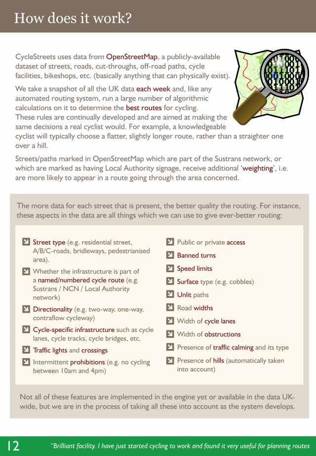
CycleStreets uses data from OpenStreetMap, a publicly-available dataset of streets, roads, cut-throughs, off-road paths, cycle facilities, bikeshops, etc. (basically anything that can physically exist).
We take a snapshot of all the UK data each week and, like any automated routing system, run a large number of algorithmic calculations on it to determine the best routes for cycling.These rules are continually developed and are aimed at making the same decisions a real cyclist would. For example, a knowledgeable cyclist will typically choose a flatter, slightly longer route, rather than a straighter one over a hill.
Streets/paths marked in OpenStreetMap which are part of the Sustrans network, or which are marked as having Local Authority signage, receive additional ‘weighting’, i.e. are more likely to appear in a route going through the area concerned.
The more data for each street that is present, the better quality the routing. For instance, these aspects in the data are all things which we can use to give ever-better routing:
Street type (e.g. residential street, A/B/C-roads, bridleways, pedestrianised area).
Whether the infrastructure is part of a named/numbered cycle route (e.g. Sustrans / NCN / Local Authority network)
Directionality (e.g. two-way, one-way, contraflow cycleway)
Cycle-specific infrastructure such as cycle lanes, cycle tracks, cycle bridges, etc.
Traffic lights and crossings
Intermittent prohibitions (e.g. no cycling between 10am and 4pm)
Public or private access
Banned turns
Speed limits
Surface type (e.g. cobbles)
Unlit paths
Road widths
Width of cycle lanes
Width of obstructions
Presence of traffic calming and its type
Presence of hills (automatically taken into account)
Not all of these features are implemented in the engine yet or available in the data UK-wide, but we are in the process of taking all these into account as the system develops.
13“Brilliant facility. I have just started cycling to work and found it very useful for planning routes and trying them out.”
Promoting legal cyclingAt all times CycleStreets attempts to respect the legal status of a path. For instance, it will never deliberately send someone the wrong way down a one-way street (though will occasionally suggest dismounting and walking along a one-way street if this avoids a much longer alternative).
Where errors are spotted within the feedback we receive, these are passed on to our data contacts to be fixed, which usually happens within a week or two.
Can we incorporate a dataset owned by the council?Yes, existing data owned by Local Authorities can be added to OpenStreetMap, our datasource, as long as it has no Ordnance Survey derived data restrictions.
For instance, do you have a dataset of all the cycle parking locations in your area, which we could show on the map? And some Local Authorities will already have data, such as allocations of named cycle routes to particular streets, or even commissioned GPS-collected cycling data. Where data is derived from Ordnance Survey data, permission from the OS would be required before any further use can be made of it. (Rules relating to OS derived data conditions are gradually being relaxed by the government, so this is getting easier.)
We can provide further advice regarding such data – just get in touch via the contact details on the back page.
How well-covered is my area?Some areas of the country do not have full coverage yet. A visual inspection of the map for your area will give a reasonable idea of completeness. We can provide more details about the level of coverage upon request, based on the OpenStreetMap Analysis Summary charts to which we have access. Many less well-covered areas are improving rapidly. We have also been talking to Cycling England about use of their survey data (see page 14).
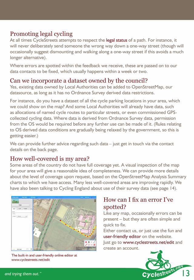
How can I fix an error I’ve spotted?Like any map, occasionally errors can be present – but they are often simple and quick to fix.Either contact us, or just use the fun and user-friendly editor on the website. Just go to www.cyclestreets.net/edit and create an account.
The built-in and user-friendly online editor at www.cyclestreets.net/edit
14
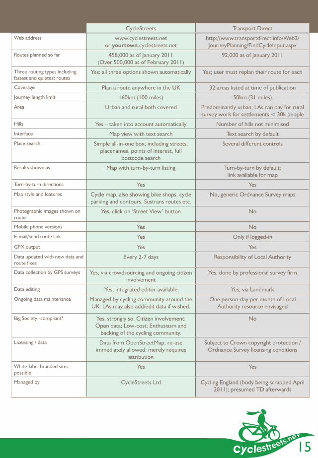
CycleStreets: leading cycle routing for the UK
You may have heard that the government is adding cycle routing within its Transport Direct portal. Local Authorities around the UK have approached us to enquire about CycleStreets and have asked us about the differences between the two systems. We have therefore assembled this information on these two pages.
Data collected by Cycling England is, subject to confirmation from the DfT of licensing compatibility and funding, due to be prepared so that it can be made available for OpenStreetMap/CycleStreets use. This will enhance the quality of CycleStreets routing still further.
References for Transport Direct can be verified from the FAQ on the Cycling England website, last updated April 2010, and from the Freedom of Information requests published on the DfT website. For full details, see www.cyclestreets.net/localauthorities/factcheck/
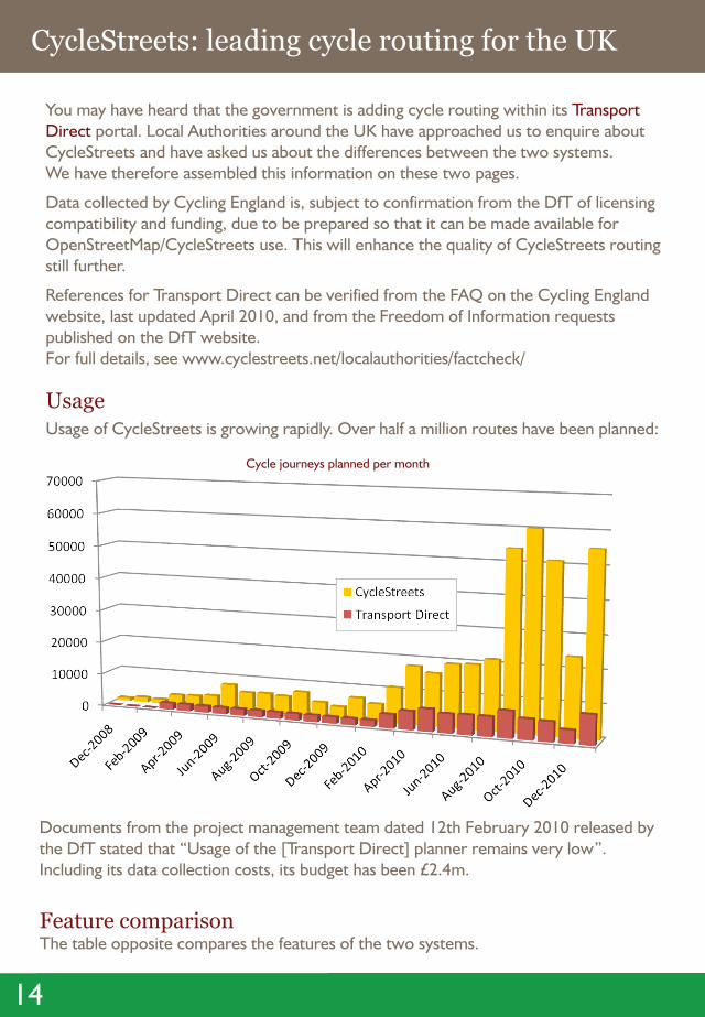
UsageUsage of CycleStreets is growing rapidly. Over half a million routes have been planned:
Documents from the project management team dated 12th February 2010 released by the DfT stated that “Usage of the [Transport Direct] planner remains very low”. Including its data collection costs, its budget has been £2.4m.
Feature comparisonThe table opposite compares the features of the two systems.
Cycle journeys planned per month
15
CycleStreets: leading cycle routing for the UK CycleStreets Transport Direct
Web address www.cyclestreets.net or yourtown.cyclestreets.net
http://www.transportdirect.info/Web2/JourneyPlanning/FindCycleInput.aspx
Routes planned so far 458,000 as of January 2011(Over 500,000 as of February 2011)
92,000 as of January 2011
Three routing types including fastest and quietest routes
Yes; all three options shown automatically Yes; user must replan their route for each
Coverage Plan a route anywhere in the UK 32 areas listed at time of publication
Journey length limit 160km (100 miles) 50km (31 miles)
Area Urban and rural both covered Predominantly urban; LAs can pay for rural survey work for settlements < 30k people
Hills Yes – taken into account automatically Number of hills not minimised
Interface Map view with text search Text search by default
Place search Simple all-in-one box, including streets, placenames, points of interest, full
postcode search
Several different controls
Results shown as Map with turn-by-turn listing Turn-by-turn by default; link available for map
Turn-by-turn directions Yes Yes
Map style and features Cycle map, also showing bike shops, cycle parking and contours, Sustrans routes etc.
No, generic Ordnance Survey maps
Photographic images shown on route
Yes, click on ‘Street View’ button No
Mobile phone versions Yes No
E-mail/send route link Yes Only if logged-in
GPX output Yes Yes
Data updated with new data and route fixes
Every 2-7 days Responsibility of Local Authority
Data collection by GPS surveys Yes, via crowdsourcing and ongoing citizen involvement
Yes, done by professional survey firm
Data editing Yes; integrated editor available Yes; via Landmark
Ongoing data maintenance Managed by cycling community around the UK. LAs may also add/edit data if wished.
One person-day per month of Local Authority resource envisaged
Big Society -compliant? Yes, strongly so. Citizen involvement; Open data; Low-cost; Enthusiasm and
backing of the cycling community.
No
Licensing / data Data from OpenStreetMap; re-use immediately allowed; merely requires
attribution
Subject to Crown copyright protection / Ordnance Survey licensing conditions
White-label branded sites possible
Yes Yes
Managed by CycleStreets Ltd Cycling England (body being scrapped April 2011); presumed TD afterwards
CycleStreets is the UK-wide cycle journey planner, offering a user-friendly way for people to plan cycle-friendly routes from A-B online or on their mobile.
CycleStreets Ltd80b York StreetCambridgeCB1 2PY
Main contact: Martin Lucas-Smith 01223 [email protected]
Map data © OpenStreetMap and contributors, licensed CC-BY-SA.
Map cartography © OpenStreetMap and contributors, licensed CC-BY-SA, OpenCycleMap, and Cloudmade.
CycleStreets LtdCompany no. 06948959Operated on a not-for-profit basis.
AwardsCycleStreets was awarded ‘Highly Commended’ in the ‘Travel Plan Innovation of the Year’ category in the 2009 ACT Travelwise Awards.
CycleStreets was a top-five finalist from over 200 groups UK-wide in the environment-themed Future Friendly Awards 2010.