Current Progress on Space Science and Technology ... · Operasi KKP Comm & Weather Aspect ... LSU...
26
Current Progress on Space Science and Technology Development in Indonesia Thomas Djamaluddin Head of National Insitute of Aeronautics and Space (LAPAN)
Transcript of Current Progress on Space Science and Technology ... · Operasi KKP Comm & Weather Aspect ... LSU...

Current Progress on Space Science and Technology
Developmentin Indonesia
Thomas DjamaluddinHead of National Insitute of Aeronautics and Space
(LAPAN)

CORE COMPETENCES OF LAPAN
2
Space & Atmosphere Science
Aerospace Technology Remote Sensing Aerospace Policy Studies
National Remote Sensing Data Bank
National Earth Observation System
RocketSatellite
Aeronautics

Space and Atmophere Science

2015
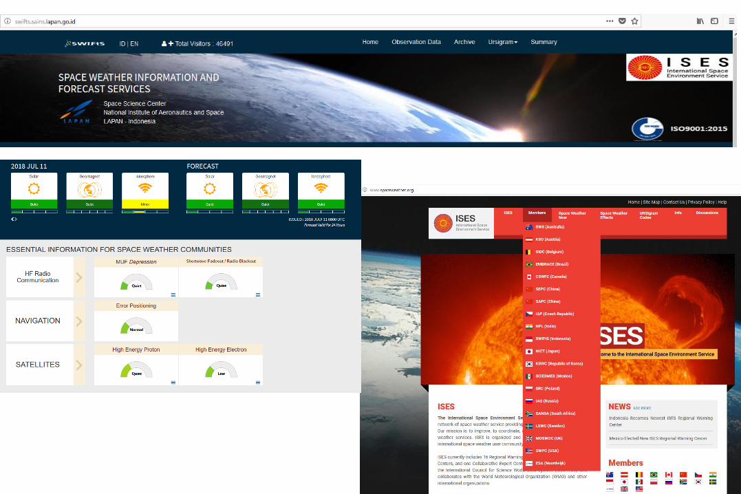
• Space Weather and space debris Information based on ground and space-based data
• Equatorial Ionospheric Anomali observation system
2016
• Development of Space weather and space debris prediction method by using real time data
• High resolution optical observation and real time data
• Real time data transfer
2017
• Development of Space Weather Information and Forecast Services as the Regional Warning CenterRadar
• Observation on ionospheric parameters, geomagnetic observation in southern Indonesia
• Development of National Observatory
2018
• Standarized space weather information
• Development of near real time analysis for space weather data
• Development of space debris model
• Ionospheric observation network and geomagnetic observation on Southern and northern Indonesia
• Development of National Obsservatory
Space Science 2015 - 2018

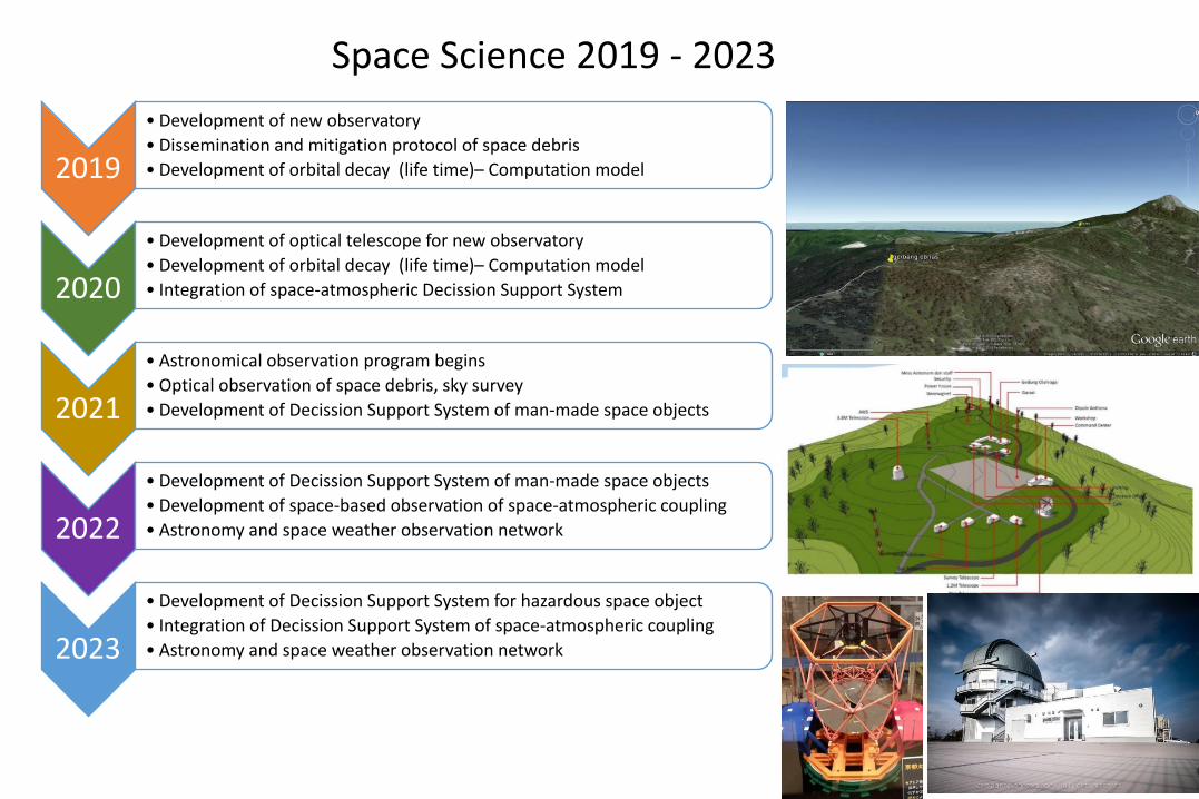
2019
• Development of new observatory
• Dissemination and mitigation protocol of space debris
• Development of orbital decay (life time)– Computation model
2020
• Development of optical telescope for new observatory
• Development of orbital decay (life time)– Computation model
• Integration of space-atmospheric Decission Support System
2021
• Astronomical observation program begins
• Optical observation of space debris, sky survey
• Development of Decission Support System of man-made space objects
2022
• Development of Decission Support System of man-made space objects
• Development of space-based observation of space-atmospheric coupling
• Astronomy and space weather observation network
2023
• Development of Decission Support System for hazardous space object
• Integration of Decission Support System of space-atmospheric coupling
• Astronomy and space weather observation network
Space Science 2019 - 2023

Development of DSS Applications 2015-2018• Satellite Disaster Early Warning System (SADEWA)
• Real time satellite-based observation and prediction of extreme rainfall and potential hidro-meteorological disaster in Indonesia to support disaster management.
• Maritime Information System (SEMAR)• Real time satellite-based observation and prediction of oceanic
and atmospheric condition in Indonesia to support marine safety and fish production. Also provide information on potential fishing ground and ships location.
• Indonesia Atmospheric Composition Information System (SRIKANDI)• Real time satellite-based observation and prediction of
atmospheric composition and air quality over Indonesia to support environmental and forest fire management.
• Indonesia Climate Change Information System (SRIRAMA)• Long term model-based climate change projection over Indonesia
to support national, regional and urban planning and development.

OB
SERV
ATIO
N
2015-2019 2020-2024 2025-2029 2030-2034 2035-2039
DSS for Ocean & Maritime Operation
DSS for Disaster Management
DSS for Transportation Safety
USER /PARTNER
BENEFIT FOR THE NATION/ COMMUNITY
LAPAN Flying Laboratory in
Operation
DSS for Defense & Security
DSS for Food Security DSS for Energy Security
DSS for Atmospheric Environment
DSS for Water Resource Management
Integrated Atmosphere-Space
DSS
DSS for Climate Change Adaptation & Mitigation
DSS for Community Health & Epidemiology
DSS for Forest & Ecosystem Management
DECISION SUPPORT SYSTEM DEVELOPMENT ROADMAP
PR
EDIC
TION
Equatorial Atmosphere Model
HPC 2000 Cores
Atmosphere-Ocean Coupled ModelHPC 5000 Cores
Climate Model + Data Assimilation
HPC 10,000 Cores
Atmosphere-Space Coupled Model
HPC 20,000 Cores
Satellite, Radar, Airborne & Terrestrial
Observation
LAPAN Rocket Sounding in Operation
LAPAN Satellite Observation in
Operation
CENTER OF ATMOPHERIC SCIENCE AND TECHNOLOGY

Aerospace Technology

2014
LSA
2013 2019
LSA Series 01Utility/Exp. aircraft
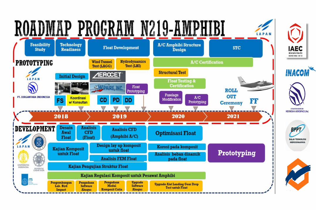
Preliminary Design N219
Sertifikasi LSU 03Design Capasity
Akses LandasanOps & Flying Lab
1st flightSertifikasi N219
PrototypeNational
Transportation
LSU - 02 – LDEmergency flight
Operasi KKPComm & Weather
AspectMaritime operation
Prototype Float
Basic Prototype LSU Series
Konsolidasi UKM DirgantaraEngineering Service
Radarsat
Vesseldetection/IllegalFishingDatanonAISandorAIS
OPERASILSUUNTUKSUPPORTPENANGGULANGANILLEGALFISHINGDataValidation- DeterrentEffect– ReduceCostOperation
NeedtoValidateINDESO KKP
LSUmenuju darah sasaranuntuk
memastikan/menvalidasikapal pencuri/melakukan
patroli/pengintaian sebelumkapal penyergap melakukanoperasi dengan sasaran yang
pasti
LSUtakeoffdari kapalKKPmenuju daerahdengan koordinat dari
Radarsat/DataSatelit/AIS
DataLokasi
Biaya Operasikapal lebihefektif danefisien
Kapal Patroli PembawaLSUsiap menuju daerahsasaran
CONOPS MSS
PenghargaanKarya anak Bangsa
Maritime operation – Pemda – garis pantai – NSPK – kebencanaan
Study Area
Subang – Indramayu, Jawa Barat
• Lahan sawah : irigasi dan tadah hujan
11
Subang
Jalur terbang LSA Titik pengamatan
Indramayu
Descending Ascending
Akuisisi Radarsat PemanfaatanLSA
Pengembangan Lab. Bertahap
PengembanganTesting Tools
Kendali u MALE LSA02
PengembanganPUI Penerbangan
Uji terbang & sertifikasiLSU05
PenggunaanBRISat untukKomunikasiLSU/UAV
PengembanganRumpin sebagaiAeronautics Tech. Park
PengembanganN219A, Feasibility study, PengembanganFloat Gear
ModifikasiManned Aircraft ke Unmanned Aircraft

20202019 2023
Ground Test System Komunikasi UAV base on
Satelit
Simulasi dan Ground Test System KendaliMALE UAV-LSAUAV
PengembanganSystem Avionic Mandiri
Pemasangan System Sensor Aircraft,
sehingga menjadiAircraft
Instrumentation
Pemasangan System Kendali, Actuator dan On
Board Processot ke Aircraft
Pemasangan flight Test Instrumentation untuk
kepentingan validasi dantest flight LSA MALE UAV
Pelaksanaan Test Flight Hasil konversi Manned Aircraft ke Un Manned Aircraft
2022
ValidasiTesting Tools danKomponenkendali
Integrasi Komunikasi Satelit, System LSU dan LSA MALE
menjadi System Pemantauan berbasis MALE
dan Tactical UAV
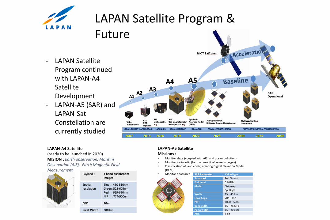
LAPAN Satellite Program & Future
LAPAN-A4 Satellite (ready to be launched in 2020)MISION : Earth observation, Maritim Observation (AIS), Earth Magnetic Field Measurement
Payload-1 4 band pushbroom imager
Spatialresolution
Blue : 450-510nm Green: 523-605nm Red : 629-690nm NIR : 774-900nm
GSD 20m
Swat Width 300 km
LAPAN-A5 SatelliteMissions :• Monitor ships (coupled with AIS) and ocean pollutions • Monitor ice in artic (for the benefit of vessel voyages) • Classification of land cover, creating Digital Elevation Model
(DEM). • Monitor flood area. SAR Parameter Value/type
Polarisasi Full Circular
Frekuensi 5.6 GHz
Mode Stripmap
Spotlight
Swath 15 – 45 Km
Look Angle 20° – 35 °
PRF 4000 – 5000
Bandwidth 15 – 28 MHz
Pulsa width 15 – 20 usec
ADC 5 bit
- LAPAN Satellite Program continued with LAPAN-A4 Satellite Development
- LAPAN-A5 (SAR) and LAPAN-Sat Constellation are currently studied

LAPAN-A1/LAPAN-
TUBSAT
2007
LAPAN-A2/LAPAN-Orari
2015
LAPAN-A3/LAPAN-IPB
2016
LAPAN-A4
2020
LAPAN-A5
2022
LAPAN Satellite Development
Video Survailance, Store & Forward
Digital Camera, AIS, Amateur Radio
Imager, AIS, Magnetometer
High Res Multispectral, AIS, Magnetometer
SAR, AIS
SATCOM, AIS

LAPAN Satellite DevelopmentCooperation Focus & Plan
• Sat Usage & Application
• Design of Satcom LEO, & SAR
• AIS Sat Data Center
(PT. Telkom, JAXA, Hokkaido & Chiba Univ, ISRO, ORARI, Univ, & Local Govt, Etc
01 02
• Sat Usage & Application
• Design of Satcom LEO, & SAR
• LAPAN-A4 AIT
(PT. Telkom, JAXA, Hokkaido & Chiba Univ, ISRO, ORARI, Univ, & Local Govt, Etc
03
• Sat Usage & Application
• Network of Satcom LEO, & SAR
• TTC GS Network
(Startup, PT. Telkom, JAXA, NASA, ISRO, KSAT, Univ & Local Govt, Etc
04
• Sat Usage & Application
• Design of Satcom LEO, & SAR
• AIT of Satcom LEO/SAR
(Startup, PT. Telkom, JAXA, ISRO, NASA, ESA, Univ, & Local Govt, Etc
05
• Sat Usage & Application
• New Satellite Industry
• Ops of Satcom LEO/SAR
(Startup, PT. Telkom, JAXA, ISRO, NASA, ESA, ORARI, Univ, & Local Govt, Etc
2021 2022 202320202019

Rocket Development Achievements
2014 2015 2016 2017 2018
RX 1220 Dissemination Joint Program
RX 320 Dissemination
RX 450 Qualification Tests
RX 1220 Dissemination Joint Program
RX 320 Payload Joint Program – TUB
RX 450 Qualification Tests
RX 1220 Dissemination Joint Program
RKX TJ 200 Qualification Tests
RX 450 Acceptance Tests
RX 1220 Dissemination Joint Program
RKX TJ 200 Qualification Tests
RX 450 Acceptance Tests
RX 1220 Dissemination Joint Program
RKX TJ 200 Qualification Tests
RX 450 DisseminationJoint Program

Rocket R&D Future Plan
2019 2020 2021 2022 2023
Multi Stage Sounding Rocket Joint Cooperation w/ China
RX 320 Atmospheric Sensor Payload Flight Test Joint Program w/ TU Berlin
Indonesian SpaceportFeasibility Studies
Indonesian Spaceport Design and Preparation Coordination
Spaceport Development
Rocket Technology Dissemination Joint Cooperation Program w/ National Consortium, private sectors and universities for RX 1220, RX 450, Lightning Trigger and Weather Modification usages
High Speed Rocket Control System w/ turbojet and solid rocket motor R&D
Liquid Propellant Rocket Research and Development Qualification and Acceptance Tests
Multi Stage SoundingRocket Dissemination
Qualification and Acceptance Tests
DisseminationLow-speed RKX Qualification & Acceptance Tests

Remote Sensing Technology & Application

LAPAN National Remote Sensing Data Bank(BDPJN) 2014-2018
2014 2015 2016 2017 2018
• Prototype platform services for Gov. Institution
• Integration system for data acquisition and processing system.
• Platform for near real time data services
• ISO 9001:2008• Customer
satisfaction index (CSI) 85,41
• Disaster recovery center (DRC)
• System Integration for data acquisition, processing system, and data distribution
• ISO 9001:2008• CSI 89,77
• Center of Excellence for Tech. & Data RS (PUI)
• Upgrading data acq. capability: Very High Resolution Optical and SAR Ground Station
• Data services for National Priority Programs
• ISO 9001:2015• ISO 27001:2013• CSI 90,69
• Services for all Government Ministries / Agencies
• Services for all Government Provinces
• Data center web portal (BDPJN portal)
• Building global business: Prototype platform services for South East Asia countries

• All government institution data link and access (Implementation Space Law UU 21/2013 and Gov. Regulation PP 11/2018), serve National Priority Program
• Building national GS network (Nat/International Satellites), upgrage SPACeMAP• Building the national business community: start up, UMKM• Joint development with Interntional private companies for regional data node
• All government institution data link and access (Implementation Space Law UU 21/2013 and Gov. Regulation PP 11/2018), serve National Priority Program
• Building national GS network (Nat/International Satellites), upgrage SPACeMAP• Building national business community: start up, UMKM • Joint development with International private companies for regional data node
• All government instution data link and access (Implementation Space Law UU 21/2013 and Gov. Regulation PP 11/2018), serve National Priority Program, Operation SPACeMAP
• Network of National GS for National/Internatiional Satellites, Upgrade SPACeMAP• Building national business community: start up, UMKM• Joint development with International private companies for regional data node
• All government institution data link and access (Implementation Space Law UU 21/2013 and Gov. Regulation PP 11/2018), serve National Priority Program, Operation SPACeMAP
• Building regional/international GS network• Building national business community: start up, UMKM• Joint development with Global private company for regional data
node
• All government institutions data link and access (Implementation Space Law UU 21/2013 and Gov. Regulation PP 11/2018), serve National Priority Program, Operation SPACeMAP
• Community of RS companies to serve national and regional needs
• Operational SEA GS Network• Operational Regional Data Node (ReDaNo) for SEA countries
2019
2020
2021
2022
2023
Next 5 years plan (2019-2023)

NATIONAL INSTITUTE OF AERONAUTICSAND SPACE OF INDONESIA
REMOTE SENSING APPLICATION CENTER
Remote Sensing Application 2014 - 2018
2014: National Earth Observation System (SPBN) to provide information about Natural Resources and Disaster Mitigation based on in-house research
2015: National Earth Observation System (SPBN) to provide information about Natural Resources and Disaster Mitigation at Province level (34 provinces finished 2015-2017)
2016: Automated processing system for Potential Fishing Ground Information from Remote Sensing
Example use of the measurement tools2017: Remote Sensing for Crop InsuranceResearch collaboration with Dutch Institutions (Geospatial for Indonesia/G4INDO Project)
2018: Updated National Earth Observation System (SPBN) to provide information about Natural Resources and Disaster Mitigation

Natural Resources Environment and Disaster Other Strategic
Cannabis identification
NATIONAL INSTITUTE OF AERONAUTICSAND SPACE OF INDONESIA
REMOTE SENSING APPLICATION CENTER
Remote Sensing Application cluster 2014-2019

Lombok Earthquake
NATIONAL INSTITUTE OF AERONAUTICSAND SPACE OF INDONESIA
REMOTE SENSING APPLICATION CENTER
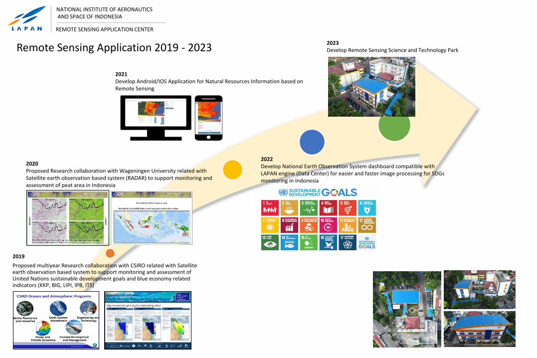
Remote Sensing Application 2019 - 2023
2019
Proposed multiyear Research collaboration with CSIRO related with Satellite earth observation based system to support monitoring and assessment of United Nations sustainable development goals and blue economy related indicators (KKP, BIG, LIPI, IPB, ITS)
2020Proposed Research collaboration with Wageningen University related with Satellite earth observation based system (RADAR) to support monitoring and assessment of peat area in Indonesia
2022Develop National Earth Observation System dashboard compatible with LAPAN engine (Data Center) for easier and faster image processing for SDGs monitoring in Indonesia
2023Develop Remote Sensing Science and Technology Park
2021Develop Android/IOS Application for Natural Resources Information based on Remote Sensing
http://lapan.go.id/
NATIONAL INSTITUTE OF AERONAUTICS AND SPACE(LAPAN)