County Engineers Association of Ohio
95
prepared by the County Engineers Association of Ohio 37 West Broad Street, Suite 660, Columbus, OH 43215-4132 614/221-0707( PHONE) 614/221-5761 (FAX) E-mail: [email protected] Home Page: http://www.ceao.org in cooperation with the County Commissioners Association of Ohio Research and Educational Foundation 37 West Broad Street, Suite 650, Columbus, OH 43215-4132 614/221-5627 (PHONE) 614/221-6986 (FAX) Home Page: http://www.ccao.org financial assistance provided by Ohio Department of Development Community Development Division Office of Local Government Services November 2000
Transcript of County Engineers Association of Ohio
prepared by the
County Engineers Association of Ohio37 West Broad Street, Suite 660, Columbus, OH 43215-4132
614/221-0707( PHONE) 614/221-5761 (FAX)E-mail: [email protected]
Home Page: http://www.ceao.org
in cooperation with the
County Commissioners Association of OhioResearch and Educational Foundation
37 West Broad Street, Suite 650, Columbus, OH 43215-4132614/221-5627 (PHONE) 614/221-6986 (FAX)
Home Page: http://www.ccao.org
financial assistance provided by
Ohio Department of DevelopmentCommunity Development Division
Office of Local Government Services
November 2000

INTRODUCTION, SUBDIVISION REGULATIONS 2
Acknowledgement
This project was undertaken by the County Engineers Association of Ohio (CEAO) in aneffort to provide sound regulatory guidance to counties. Athens County Engineer ArchieStanley and Coshocton County Engineer Fred Wachtel were primarily responsible forthe project under the CEAO Survey Functions Committee. The project also included theinvolvement of the County Commissioners Association of Ohio (CCAO) Research andEducational Foundation.
Research and the compilation of initial drafts were performed by Ms. Elena Romero-Jenson,a graduate student in City and Regional Planning at The Ohio State University. RobertEichenberg, General Manager of Round River Planning and Design, Ltd., and now Directorof the Athens County Regional Planning Commission, coordinated the project for CEAO’sSurvey Functions Committee. The final document was modified as a result of commentsfrom a variety of individuals and organizations and by CEAO Executive Director GlennSprowls, CCAO Executive Director Larry L. Long, and CCAO Policy Analyst Cheryl Subler.CCAO Public Relations Associate Mary Jane Neiman coordinated the final layout of thedocument, which was performed by Chris Holtman, CEH Publication Services.
In addition, the following organizations and individuals are recognized for their assistance inthe preparation of these model regulations:
ORGANIZATIONSOhio Home Builders Association
Ohio Association of Realtors
Professional Land Surveyors of Ohio
Ohio Planning Conference
County Planning Directors Association
Association of Ohio Health Commissioners
Ohio Township Association
Ohio Association of Regional Councils
INDIVIDUALSBuck Adams, Director, Medina County Emergency Management Agency
John Anning, Director, Hancock County Regional Planning Commission
Neil Babb, Madison County Engineer
Joe Bachman, Tuscarawas County Engineer
Chris Bauserman, Delaware County Engineer
John Branner, Professional Surveyor, Athens
Don Brosius, Attorney, Columbus, Franklin County
Randy Bush, Morrow County Engineer
Tim DeWitt, Director, Delaware County Planning Commission
INTRODUCTION, SUBDIVISION REGULATIONS 3
Lynne Erickson, Portage County Planning Commission
Bruce Freeman, AICP, Director, Medina County Planning Commission
Barb Furbee, Map Department Supervisor, Guernsey County Engineer’s Office
Richard Hardison, Morgan County Engineer
Chris Hartman, Medina County Soil & Water Conservation District
Rob Kagler, Ashtabula County Planning Commission
Dan Keller, Summit County Planning Commission
Jeff Lee, Lee Surveying & Mapping Co., Inc.
Ken Lengieza, Director, Marion County Regional Planning Commission
Jeff McInturf, Professional Surveyor, McConnelsville, Morgan County
Mike McLain, Professional Surveyor, Mt. Gilead, Morrow County
Bill Neugebaur, Allotment Engineer, Summit County Engineer’s Office
Arnold Oliver, Director, Holmes County Planning Commission & Office of Economic Development
Terrence Pearson, Tax Map Director, Portage County Engineer’s Office
Birdie Pedersen, Attorney, Athens County Prosecutor’s Office
Kyme Rennick, Chairperson, Ohio Mine Subsidence Governing Board
Tim Richardson, Franklin County Planning Commission, The Nature Conservancy
Mary Sampsel, Professional Engineer, Union County Engineer’s Office
Bob Schroeder, Director, Greene County Regional Planning and Coordinating Commission
Tom Schultheis, Chief Surveyor, Washington County Engineer’s Office
Marcia Staniland, Director, Athens County Regional Planning Commission
John Stultz, Deputy Engineer, Hancock County
Ted Sushka, Washington County Engineer
Bill Temple, Clinton County Engineer
Ralph Williams, Chief Surveyor, Lucas County Engineer’s Office
Audie Wykle, Tax Plat Mapper, Hocking County Engineer’s Office

INTRODUCTION, SUBDIVISION REGULATIONS 4
Preamble
A resolution of __________________ County, Ohio enacted in accordance with Chapter711 of the Ohio Revised Code and for the purpose of protecting the public health, safety,comfort, convenience and general welfare; regulating the development of subdivided areas;promoting the proper arrangement and coordination of streets or other roads in relation toexisting or planned streets or roads and to the county or regional plan; providing for thelayout of lots; providing for adequate and convenient provision of open spaces, utilities,recreation, and access to service and emergency vehicles; encouraging the avoidance offuture congestion of population; providing for adequate provision of water, drainage, sewer,and other sanitary facilities; providing for the administration of these Regulations and defin-ing the powers and duties of the administrative officers; prescribing penalties for the viola-tion of the provisions in this resolution or any amendment thereto; and for the repeal thereof.

ARTICLE 1, SUBDIVISION REGULATIONS 1
Article 1GENERAL PROVISIONSStandards
100 TitleThese rules, regulations and standards shall be officially known as the “Subdivision Regulations ofthe County of _________ Ohio,” and shall hereinafter be referred to as “these Regulations.”
101 Policya. It is declared to be the policy of_________ County to consider the subdivision of land and its
subsequent development as subject to the control of _________ County, pursuant to any officialcomprehensive plan (when one exists) for orderly, planned, safe, efficient, and economical de-velopment.
b. Land to be subdivided shall be of such character that it can be used safely for building purposes,and shall not be subdivided until adequate facilities and improvements such as drainage, water,sewerage, and public open space are provided, or a performance bond is filed to assure that therequired improvements will be made by the subdivider.
c. The existing and proposed public improvements shall conform with and be related to the pro-posals shown in the comprehensive plan, capital improvement program, and development pro-grams of _________ County, and it is intended that these Regulations shall supplement andfacilitate the enforcement of the provisions and standards contained in building codes, housingcodes, zoning resolutions, the comprehensive plan, and the capital improvement program of_________ County.
102 PurposeThese Regulations are adopted as minimum requirements for the regulation and control of land sub-division within the unincorporated area of the county. These regulations are intended to:
a. Establish standards for logical, sound, and economical development.
b. To provide for adequate light, air and privacy, to secure safety from fire, flood, and other danger,to prevent population congestion and overcrowding of the land, to provide orderly expansionand extension of community services and facilities at minimum cost and maximum convenience.
c. To provide for the proper arrangement of streets and highways in relation to those existing orplanned and to provide for the most beneficial relationship between use of land, buildings, traf-fic, and pedestrian movements.
d. To improve the quality of life through protection of the total environment, including the preven-tion of air, water, light, and noise pollution, the prevention of soil erosion, and the preservation ofnatural beauty and topography.
e. To ensure appropriate surveying of land, preparing and recording of plats and the equitablehandling of all subdivision plats by providing uniform procedures and standards for observanceby both _________ County and developers.
103 AuthorityThe Ohio Revised Code, Chapter 711, enables the board of county commissioners and the planningcommission of _________ County to adopt regulations governing plats and subdivisions of land withinthe unincorporated area of the county.
ARTICLE 1, SUBDIVISION REGULATIONS 2
104 Public PurposeRegulation of the subdivision of land and the attachment of reasonable conditions to land subdivisionis an exercise of public police power delegated by the state to _________ County pursuant to Chapter711 of the Ohio Revised Code. The developer shall be in compliance with conditions established bythe planning commission for design, dedication, improvement, and restrictive use of the land to con-form to the physical and economic development of _________ County and the health, safety, andgeneral welfare of the future lot owners of the subdivision and of _________ County generally.
105 Jurisdictiona. These Regulations shall be applicable to all subdivisions of land located within the unincorpo-
rated area of ________ County.
b. A city that has adopted a major thoroughfare, parks and public open space plan for the territorywithin the city limits and for the territory within three miles of the city, or any portion thereof, andhas adopted subdivision regulations may exercise extraterritorial jurisdiction for a distance of upto three miles of its corporate limits if county or township zoning is not in effect within the area asprovided in Section 711.09 of the Ohio Revised Code. The city planning commission may re-ceive advice from the county or regional planning commission upon all subdivision plats locatedwithin three miles of the corporate limits.
c. A village located in any county that contains no city that has adopted a major thoroughfare,parks, and public open space plan for territory within the village limits and for territory within oneand one-half miles of the village, or any portion thereof, and has adopted subdivision regulationsmay exercise extraterritorial jurisdiction for a distance of up to one and one-half miles from itscorporate limits if county or township zoning is not in effect within the area and no county subdi-vision regulations are in effect as provided in Section 711.09 of the Ohio Revised Code. Thevillage planning commission, platting commissioner or village council may receive advice fromthe regional or county planning commission upon all subdivision plats located within one andone-half miles of the corporate limits.
d. The regional or county planning commission and the city with subdivision regulation jurisdictionover unincorporated territory within _________ County may agree, in writing, that the approvalof the plat by the city, as provided in Section 711.09 of the Ohio Revised Code, shall be condi-tioned upon receiving advice from or approval by the regional or county planning commission.
e. The regional or county planning commission may cooperate with any city or village located in_________ County in the review of subdivision plats occurring on lands adjoining the corpora-tion line of said city or village or within a reasonable distance of same. The regional or countyplanning commission may, as a condition for such cooperation, and in order to carry out theseRegulations more effectively, seek an agreement with any city or village. The term of the agree-ment may permit joint review, by the regional or county planning commission and any city orvillage, of subdivisions occurring next to or within its corporate limits.
f. County, regional, and municipal planning commissions and other agencies with subdivision ap-proval authority will have to reach agreement on review of lands, proposed for subdivision,which lie partially within and partially outside of the three or one and one-half mile limit area.
106 Relation to Other Lawsa. The provision of these Regulations shall supplement the laws of the State of Ohio, other resolu-
tions adopted by the board of county commissioners or township trustees, or the rules andregulations promulgated by authority of such law or resolution relating to the purpose and scopeof these Regulations.
b. No subdivision plat shall be approved for recording until the requirements of these Regulationshave been met and certification thereof has been endorsed upon the plat by the appropriate

ARTICLE 1, SUBDIVISION REGULATIONS 3
reviewing authority.
c. Whenever the requirements of these Regulations are at variance with the requirements of otherlawfully adopted rules, regulations, or resolutions, the most restrictive or that imposing the high-est standard shall govern. These Regulations shall be interpreted as minimum requirements.
d. Whenever a township or part thereof has adopted a county or township zoning resolution, underChapter 303 or 519 of the Ohio Revised Code, all proposed subdivisions shall meet the require-ments of said zoning resolution, as well as the provisions of these Regulations.
107 Validity and SeparabilityIf, for any reason, any clause, provision or portion of these Regulations shall be held invalid or uncon-stitutional by a court of competent jurisdiction, such decision shall not affect validity or legality of theseRegulations as a whole, or any part thereof, other than the part so held to be invalid. These Regula-tions shall not abate any legal action pending under prior subdivision regulations and shall not inter-fere with other applicable laws and regulations or with deed restrictions.
108 Saving ProvisionThese Regulations shall not be construed as abating any action now pending under, or by virtue of,prior existing subdivision regulations, or as discontinuing, abating, modifying or altering any penaltyaccruing or about to accrue, or as affecting the liability of any person, firm, or corporation, or aswaiving any right of the county under any section or provision existing at the time of adoption of theseRegulations, or as vacating or annulling any rights adopted by any person, firm, or corporation bylawful action of the county except as shall be expressly provided for in these Regulations.
109 EnactmentThese Regulations shall become effective from and after the date of their approval, adoption, oramendment by the county or regional planning commission and the board of county commissionersafter public hearing and certification to the county recorder as required by Chapter 711 of the OhioRevised Code. Henceforth, any other regulations previously adopted by _________ County shall bedeemed to be repealed. These Regulations shall in no way affect any subdivision having receivedpreliminary plan approval prior to the effective date of these regulations or any amendment thereto,provided, however, that no changes to the preliminary plan, as approved, are introduced by the sub-divider.
PASSED:_________________________________________________(Date)
SIGNED: _________________________________________________President of the Board of County Commissioners
ATTEST: _________________________________________________County Commissioners Clerk

ARTICLE 1, SUBDIVISION REGULATIONS 4
Commentary on Article 1
100 TitleResolutions are typically given an abbreviated title for reference purposes. In this Resolution, the Model Subdi-vision Regulations will be referred to as “these Regulations”. Any suggested standards may be substituted afterconsideration of the local needs.
101 PolicyThe statement of policy and purposes is extremely important since it shows that the power to adopt Regulationsis legitimately granted by the state to the county and that counties are not acting arbitrarily when they imposereasonable standards to protect public health, safety, and welfare.
These Regulations shall be adopted to compliment other regulations such as a zoning resolution, the compre-hensive plan, and capital improvement programs, when they exist, and shall be used as a tool for overall com-munity planning consistent with public health, safety, and welfare. It is important that any subdivision reviewprocess begin with the question, “Is this development consistent with the comprehensive plan?” The subdividerhas the responsibility of planning and building public improvements that will not endanger the public and willbe an asset to the county.
102 PurposeThese Regulations identify objectives such as preservation of open space, promotion of land values, preserva-tion of the environment, assurance of adequate public facilities and services, and protection of the communityfrom unnecessary costs that will result from inadequate development. The relationship between these Regula-tions and the comprehensive plan, and capital improvement programs should be expressed. Subdivision Regu-lations shall not be used as isolated tools, but rather must be integrated in a comprehensive scheme to provide anoverall program of orderly growth and adequate facilities through a sequential development policy.
103 AuthorityThe model subdivision regulations are drafted for use by county or regional planning commission administra-tion. While municipalities were included in the original draft, any reference to municipalities has been elimi-nated from the final draft at the request of the Ohio Municipal League. The term “planning commission” refersto the county or regional planning commission. In counties where there is not an established planning commis-sion, plat approval rests with the board of county commissioners as specified in Sections 711.041 and 711.05 ofthe Ohio Revised Code.
104 Public PurposeSubdivision regulation is the imposition of reasonable conditions on a subdivision of land and is an exercise ofpublic police power related to the protection of public health, safety, and general welfare of the community. Tobe valid, the county must adopt reasonable and specific criteria for imposing conditions and restrictions uponthe subdivider. While a county should be permitted to require standards over and above those stipulated in theseRegulations, if necessitated by special site conditions, such modifications should be limited to only the specificcase. All standards suggested in this model should be carefully reviewed prior to adoption and modifiedto meet local needs where necessary. Dimensional requirements contained in this model are only sugges-tions, and each should be carefully reviewed prior to adoption.
105 JurisdictionThe Ohio Revised Code under Sections 711.05, 711.09, 711.10, and 711.101 enables boards of county commis-sioners and county and regional planning commissions to adopt regulations governing plats and subdivisions ofland within their jurisdiction. Authority for subdivision approval by municipalities outside of their corporate
ARTICLE 1, SUBDIVISION REGULATIONS 5
limits has been severely limited as a result of recent state legislation (HB 22 of the 121st General Assembly). Inthe case of cities, a three-mile, extraterritorial jurisdiction exists but only where there is no county or regionalplanning commission in existence and only if there is no county or township zoning in effect in the townshipwithin three miles of the city. In the case of a village, a one and one-half mile extraterritorial limit exists. For avillage to exercise this authority, however, there is an additional restriction that there also must be no countysubdivision regulations in effect in the county. Thus if the county has adopted subdivision regulations, a villagemay not exercise any extraterritorial jurisdiction. A requirement for exercising extraterritorial control is that a“...plan for the major streets or thoroughfares and for the parks and other open public grounds of a city or anypart thereof, or for the unincorporated territory or any part thereof...” shall be adopted. A city or village may alsochoose to exercise extraterritorial jurisdiction in an area less than the maximum authorized by law.
It is important that a formal arrangement between the county and the municipality be provided for subdivisionreview. Many public and private entities have a stake in the subdivision process and lines of communicationmust be clear and open.
106 Relation to Other LawsThese Regulations are not intended to interfere with any other provision of law except as provided in theseRegulations. Where any provision of these Regulations is different from those imposed by any other provisionof these Regulations or any other resolution, or other provision of law, the provision which is more restrictive orimposes a higher standard shall control.
107 Validity and SeparabilityA separability provision is necessary to protect the entire resolution if a particular section is declared to beinvalid.
108 Saving ProvisionThis section provides that these Regulations will not abate any action pending under preexisting subdivisionregulations. Rights of both private and government parties that are established prior to the enactment of theseRegulations will not be impaired. These Regulations may be enacted to complement existing land use regula-tions, and in case of conflict the strictest provision or higher standard will prevail.
ARTICLE 2, SUBDIVISION REGULATIONS 1
Article 2ADMINISTRATIONStandards
200 Administration, Enforcement and InterpretationThese Regulations shall be administered by the county or regional planning commission of _________County. The planning commission, assisted by other government agencies, legal counsel, and throughother advice it may solicit, shall administer and enforce these Regulations. Discretionary, conflicting,or disputed aspects of these Regulations shall be interpreted by the planning director or other indi-vidual designated by the county commissioners or planning commission.
201 Reservations and RepealsUpon the adoption of these Regulations, according to law, the Subdivision Regulations of _________County adopted [date], as amended, are hereby repealed, except as to those sections expresslyretained in these Regulations.
202 AmendmentsThe planning commission may amend, supplement or change these Regulations in accordance withthe appropriate sections of the Ohio Revised Code. However, the planning commission may onlyamend, supplement or change regulations, requiring the actual construction of improvements, orposting of performance guarantees, after review and adoption by the county commissioners.
203 Variances, Exceptions and Waiver of ConditionsWhere, due to exceptional topographic or other physical conditions, the planning commission findsthat extraordinary and unnecessary hardship may result from strict application of these Regulations,or the purposes of these Regulations may be served to a greater extent by an alternative proposal, itmay approve variances, exceptions, and waivers of conditions, provided that they will not be detri-mental to the public health, safety, or welfare or injurious to other properties. Variances for roadwayspecifications and construction standards can only be made by the Board of County Commissioners.Recommendations regarding variances may be provided by the planning commission. Such vari-ances shall not have the effect of nullifying the intent and purpose of these Regulations, the compre-hensive plan, or the zoning resolution, when they exist.
In granting variances or modifications the planning commission may require such conditions as will, inits judgment, secure substantially the objective of the standards or requirements so varied or modi-fied.
An application for relief may be denied if an owner requests it merely for his own convenience, suchas when the land is not usable due to error or poor assumptions on the owner’s part, or when the onlysupporting evidence is that compliance would add significantly to development costs.
204 Expiration or ExtensionFailure to comply with stated time periods of these Regulations shall result in the expiration of theapplication and associated planning commission approvals. Before expiration, the subdivider mayprovide a letter and extension fee stating why these time periods cannot be met and requesting theirextension. The subdivider is solely responsible for knowing expiration dates and meeting or extendingthem in accordance with these Regulations. The planning commission shall have no duty, obligationor responsibility to remind or notify subdividers of approaching expiration dates.

ARTICLE 2, SUBDIVISION REGULATIONS 2
205 Voided ApplicationsAn application shall become void and have no rights, standing, or status under these Regulations,upon expiration, withdrawal, or disapproval.
206 Recording of PlatNo plat of any subdivision shall be recorded by the county recorder or have any validity until said plathas received a final approval in the manner prescribed in these Regulations.
207 Revision of Plat after ApprovalNo change, modification, or revision shall be made in any plat of a subdivision after approval has beengiven by the planning commission, and endorsed in writing on the plat, unless said plat is first resub-mitted to the planning commission.
208 FeesThe board of county commissioners shall establish a schedule of fees, charges, expenses, and col-lection procedures for administration of these Regulations. The schedule of fees shall be posted inthe office of the planning commission. Until all applicable fees, charges and expenses have been paidin full, no action shall be taken on any application or appeal. The subdivider shall be solely responsiblefor submittal of the plat and payment of fees to the local agency having jurisdiction regarding reviewand/or approval of proposed improvements, including water and sanitary sewage facilities.
209 Violations and PenaltiesWhoever transfers, offers for sale, or leases for a period of more than five years any lot, parcel or tractof land from a plat of a subdivision before such plat has been recorded in the office of the countyrecorder or that violates these regulations shall forfeit and pay the sum of not less than ten dollars($10) nor more than five-hundred dollars ($500) for each lot, parcel, or tract of land so sold. Thedescription of such lot, parcel, or tract by metes and bounds in the deed or transfer shall not serve toexempt the seller from the forfeiture provided in this section.
No building permit shall be issued for the construction of any building or structure located on a lot orplat subdivided or sold in violation of the provisions of these Regulations, nor shall the county haveany obligation to issue certificates of occupancy or to extend utility services to any parcel created inviolation of these Regulations.
A county recorder who records a plat contrary to the provisions of these Regulations shall forfeit andpay not less than one-hundred dollars ($100) nor more than five-hundred dollars ($500), to be recov-ered with costs in a civil action by the prosecuting attorney in the name and for the use of the county.
210 AppealAny person who believes he or she has been aggrieved by these Regulations or the actions of theplanning commission has all rights to appeal as set forth in Chapter 711 of the Ohio Revised Code orany other applicable section.

ARTICLE 2, SUBDIVISION REGULATIONS 3
Commentary on Article 2
200 Administration, Enforcement, and InterpretationThe owner of a subdivision may not transfer or sell any lot before the planning commission has granted subdi-vision approval to ensure that land is developed according to proper standards. Attempts to evade subdivisionregulations such as transfer of land to co-tenants and lot splits are subject to penalties imposed by these Regula-tions.
202 AmendmentsThese Regulations are intended to supersede existing subdivision regulations. If these Regulations need to bechanged, an amendment procedure shall be followed. A public hearing may be beneficial in order to gathercitizen input.
203 VariancesA petition for a variance shall be submitted in writing by the subdivider at the time the preliminary plan is filedfor the consideration of the planning commission. The subdivider shall describe the nature of the hardshipencountered in complying with these Regulations and how the requested deviation does not jeopardize thepublic health, safety and welfare. Upon acceptance, the request shall be scheduled for the next appropriatemeeting of the planning commission. The planning commission can not approve variances involving road speci-fications or construction standards.
204 Expiration or ExtensionOnce a preliminary plan or final plat is officially submitted by the subdivider, the planning commission has afixed time period for approval or denial. If it appears that the preliminary plan or final plat will not be approvedfor reasons that the subdivider believes he or she can remedy, a time extension may be granted so that theplanning commission does not have to turn down the plat and require resubmittal with associated fees at somefuture date. The planning commission has the right to extend the review process, with the subdivider’s writtenconsent, if questions arise and the plan or plat cannot be approved until information is gathered and the ques-tions answered.
208 FeesThe fees should be set to cover the reasonable costs of inspection, processing, and review that will be incurredby the planning commission, in order to ensure community growth without burdening local government. Thefees charged to subdividers may not be used for general revenue purposes for the county.
ARTICLE 3, SUBDIVISION REGULATIONS 1
Article 3SUBDIVISION APPLICATION, PROCEDURESAND APPROVAL PROCESSStandards
300 PurposeThe purpose of this article is to establish the procedure for review and approval of subdivisions, asauthorized under Chapter 711 of the Ohio Revised Code. The procedure is intended to provide orderlyand expeditious processing of such applications.
301 General ProcedureBefore any land is subdivided the owner of the property, or his authorized agent, shall apply for andsecure approval of the proposed subdivision in accordance with the following procedures:
a. Lot Split or Minor Subdivision: These shall be processed by an individual designated by theplanning commission and require a survey drawing, a deed with a legal description, fees, andmay include a sketch plat as recommended by the planning commission.
b. Platted Subdivision or Major Subdivision: These involve approval actions by the planning com-mission. The approval process for a major development, whether a subdivision, cluster devel-opment, or planned unit development (PUD), is essentially the same, and includes three princi-pal steps: an optional sketch plan, a preliminary plan, and a final plat.
302 Outline of Conditions for Minor SubdivisionApproval without a plat of a minor subdivision may be granted by a designated representative of theplanning commission if the proposed subdivision of the parcel of land meets all of the following condi-tions:
a. The proposed division of a parcel of land as shown on the last proceeding tax duplicate involvesno more than five (5) lots, after the original parcel has been completely subdivided, any one ofwhich is under five (5) acres (inclusive of the remainder parcel).
b. The proposed subdivision is along an existing public street, and involves no opening, wideningor extension of any street or road or public utility.
c. The proposed division is not contrary to applicable subdivision, zoning or other regulations orhas received any necessary variances.
d. The proposed subdivision is approved by the zoning inspector, Ohio Environmental ProtectionAgency (for special sanitary districts), local health department, the county engineer, and othersas may be applicable.
e. The property has been surveyed and a survey sheet and a legal description of the property issubmitted with the application.
303 Administrative Procedure and Approvala. A minor subdivision or lot split application available at the planning commission office shall be
filed by the landowner or designated representative. A complete application shall contain asurvey drawing, a deed, a legal description for each lot being created, a fee as set forth in theseRegulations, and a certification of approval by the local health department, zoning inspector,and others as may be applicable.

ARTICLE 3, SUBDIVISION REGULATIONS 2
b. After the split has been given approval by any other departments with review responsibility, thedeed, a copy of the health department approval and a copy of the survey drawing is then checkedby the designated representative of the planning commission for its conformity with these Regu-lations. The designated representative of the planning commission shall stamp and sign thedeed “approved-no plat required,” if the lot in question meets all requirements as specifiedabove, within seven (7) working days after submission.
c. The deed shall then be taken to the county auditor for the transfer of property and then to thecounty recorder where it will become a legal lot of record. Lot split requests expire if not re-corded within (1) year of initial fee payment.
d. Incomplete or deficient proposals shall be disapproved and the subdivider notified of issues andreasons for the disapproval.
304 Submission RequirementsThe application for minor subdivision shall include the following:
a. The survey shall conform to the minimum standards for boundary surveys in State of Ohio (OAC4733-37).
b. Survey boundaries and lot lines drawn on an 11”X 17” sheet and at a scale between 1”=10, and1”=100. All dimensions shall be shown in feet and hundredths of feet.
c. Location of monuments and their descriptions.
d. Location and size of all existing buildings.
e. Areas within the 100 year floodplain and within floodways, as determined from flood studies orby scaling from mapping provided by the Federal Emergency Management Agency, shall bedelineated.
f. Other items, or provisions deemed necessary by the planning commission.
305 Combining Entire Existing Tax Parcels, Replat, Subdivision Vacations,Plat of Streets, Common Open Spaces, and Easements for Public Utilities
a. Combining entire existing tax parcels can be accomplished by the county auditor without plan-ning commission approval if the existing parcels have the same deed reference, are adjacent toeach other, are not separated by a public roadway, and acreage of all parcels is combined into asingle tax parcel by filling out an “Application for Combination” at the auditor’s office listing thetax parcel numbers to be combined.
b. A subdivider proposing the re-subdivision of a plat previously recorded by the county recordershall follow the same procedures required for a major subdivision. Other proposals for the alter-ation of a plat or the vacating of a plat shall comply with Sections 711.17-711.20 of the RevisedCode.
c. Proposals for the platting of street openings, widenings, and extensions; platting of open spacesfor common use by owners, occupants, or leaseholders; and easements for the extension andmaintenance of public sewer, storm drainage, or other public utilities shall follow the same pro-cedures required for a major subdivision.
306 Transfer of Property between Adjoining Ownersa. Where a transfer of property between adjoining owners, which is less than (5) acres in size,
results in a residual parcel, which is less than (5) acres, said residual parcel shall be subject tothe requirements of these Regulations; and, the transfer of property shall be approved only if theresidual meets these Regulations. The grantees’ names on the deed shall match the ownershipof the adjacent parcel being enlarged by the transfer. Deeds for combining acreage shall include

ARTICLE 3, SUBDIVISION REGULATIONS 3
the notation: “Not to be used as a separate building site or transferred as an independent parcelin the future without planning commission approval.”
b. If the transfer of property is within a recorded subdivision it shall be submitted as a major subdi-vision if it involves the creation of any subdivision lot as a separate building tract.
307 Outline of Conditions for Major SubdivisionsA proposal involving any of the following shall be subject to major subdivision procedures:
a. More than five (5) lots, any one of which is less than five (5) acres, including the original tract.
b. Creation, widening or extension of a street or access easement.
c. Division or allocation of land as a utility or drainage easement.
d. Subdividing platted land to create additional building lots in a recorded subdivision.
308 Pre-Application Conference and Sketch Plan (Optional)a. Prior to preparing a sketch plan, the subdivider may request an informal discussion with the
designated representative of the planning commission to discuss the procedures for approval ofthe subdivision plan and to familiarize the developer with the comprehensive plan, thoroughfareplan, drainage and sewerage requirements, fire prevention, and the availability of existing utilityservices.
b. The application may combine a pre-application conference with the sketch plan. The sketchplan shall include: a completed and signed application form, ( ) copies of the sketch plan, andmay include a fee as set forth in the appendix.
309 Submission RequirementsSketch plans (preparation is optional) submitted to the planning commission, prepared in pen orpencil, shall be drawn to a convenient scale of not more than one hundred (100) feet to an inch andshall show the following information:
a. Location or vicinity map.
b. Ownership of property and adjacent properties.
c. Existing and proposed public roads and easements.
d. Existing structures.
e. North arrow.
f. Outline of areas to be subdivided.
g. Approximation of proposed lot lines.
h. Important natural features and drainage ways.
i. A written statement about storm drainage, sewage disposal, water supply, and other facilitiesthat exist in the area and the likely impacts of the development on those systems.
310 Preliminary Plan (Optional)The developer may submit a preliminary plan for review and tentative approval prior to the formulationand submittal of detailed construction drawings. The preliminary plan is conducted for the developer’sbenefit and at his discretion, its submission does not constitute a formal subdivision review pursuantto Section 711.10 of the Ohio Revised Code. With the submission of the preliminary plan, the appli-cant waives any rights to an approval under Section 711.10 of the Ohio Revised Code until such timeas application is made for final subdivision plat review and is submitted to the planning commissionfor review and approval as detailed in these Regulations.
ARTICLE 3, SUBDIVISION REGULATIONS 4
311 Preliminary Plan FormThe preliminary plan application shall contain:
a. Complete application form available from the planning commission.
b. Signed variance application form and fee set forth in the appendix (if applicable).
c. Copies of the preliminary plan containing all required information.
d. One set of conceptual subdivision improvement plans, provided that completed design draw-ings shall be required at a later time.
The preliminary plan shall be submitted in the following form:
a. Drawn at a scale between one hundred (100) feet to the inch and ten (10) feet to the inch.
b. On one or more sheets 24”X 36” or 18”X 24” in size, clearly and legibly drawn.
312 Preliminary Plan ContentThe preliminary plan shall contain the following information:
a. Proposed name of the subdivision, location by section, range, township or other survey.
b. Boundaries and acreage.
c. Name, address and telephone number of the owner, subdivider, professional surveyor and pro-fessional engineer with appropriate numbers and seals.
d. Date of survey, scale of the plat, north point, legend and a vicinity map of a scale not less than2000 feet to an inch.
e. Name of adjacent subdivisions, owners of adjoining parcels, and location of common boundarylines, extended to 200 feet beyond the boundary of the subdivision.
f. Topographic contours with intervals no greater than 2 feet at 5% slope, no greater than 5 feet forslopes over 5% and less than or equal to 15%, and no greater than 10 feet for slopes greaterthan 15%.
g. Location, width, and names of existing streets, railroad rights-of-way, easements, parks, build-ings, corporation and township lines; wooded areas, water courses, drainage patterns, and wa-ter bodies.
h. Topographic features within and adjacent to the plat for a minimum distance of 200 feet unlessaccess to adjacent property has been denied the professional surveyor.
i. Location of floodways, floodplains, and a good faith effort to identify other potentially hazardousareas.
j. A good faith effort to identify the location of environmentally sensitive areas.
k. A good faith effort to identify the soil types, derived from the USDA Soil Survey.
l. A good faith effort to identify the layout, number, dimensions of each lot, and setback lines (anote listing setback dimensions may be added in lieu of showing setback lines if the plan will bemade more legible).
m.Parcels of land reserved for public use or reserved by covenant for residents of the subdivision.
n. Point of ingress/egress or driveway locations and the distance to any existing driveway(s).
o. Type of water supply and wastewater disposal proposed, approximate locations and dimensionsof all proposed utilities and sewer lines, easements, drainage tiles, water mains, culverts, orother underground utilities within the tract or adjacent thereto.
p. Known cemeteries, historical or archeological sites.
q. Copy of proposed covenants and restrictions, and a schedule outlining the order of develop-ment of each section or phase of the subdivision.

ARTICLE 3, SUBDIVISION REGULATIONS 5
313 Additional Information for the Preliminary PlanThe following information does not apply to all projects and may be requested during the site review orrequired during review and approval of applications.
a. Statements of proposed use of lots, giving type and number of dwelling units and/or type ofbusiness or industry.
b. Conceptual plan for commercial and industrial development, showing proposed parking, load-ing areas, alleys, pedestrian walkways, streets, points of vehicular ingress/egress to the devel-opment and landscape features.
c. A drawing of all present and proposed grades and facilities for storm water drainage in caseswhere natural drainage is altered.
d. A feasibility study on sewer and water facilities for land developments of two or more dwellingunits.
e. Screening, buffering and/or noise abatement measures.
f. Typical cross-sections and centerline profiles for each proposed street, and preliminary engi-neering designs of any new bridges or culverts proposed in the project.
g. Other information, studies, items, or provisions deemed necessary or prudent to create build-able sites and to promote the public health, safety, and welfare.
314 Public HearingThe planning commission, prior to acting on a preliminary plan of a subdivision, may hold a publichearing at such time and upon such notice as the planning commission may designate.
315 FilingThe preliminary plan shall be considered officially filed after it is examined by the designated repre-sentative of the planning commission and is found to be in full compliance with the formal provisionsof these Regulations. The subdivider shall be notified by mail within five (5) working days as to thedate of official filing, which begins the thirty (30) day review period, and the meeting at which the planshall be reviewed.
316 Review and Approval of Preliminary PlansThe planning commission shall forward copies of the preliminary plan to such officials and agenciesas may be necessary for the purpose of study and recommendation. After receipt of reports from suchofficials and agencies, the planning commission shall determine whether the plan will be approved,approved with modifications, or disapproved. The reasons for such disapproval shall be stated inwriting.
The planning commission shall act on the preliminary plan within thirty (30) working days after filingunless such time is extended by agreement with the subdivider. Approval of the preliminary plan shallbe conditioned on compliance with all other applicable resolutions and regulations.
317 Preliminary Plan ExpirationThe approval of the preliminary plan by the planning commission shall be effective for a maximumperiod of one (1) year from the date of its approval unless an extension of the approval has beengranted in writing by the planning commission. If the final plat application is not accepted within one(1) year, the preliminary plan approval shall expire and become void.
318 Preliminary Plan RecallThe designated representative of the planning commission may recall unplatted portions of the pre-
ARTICLE 3, SUBDIVISION REGULATIONS 6
liminary plan for consideration, and reapproval, modification, or disapproval by the planning commis-sion. A recall may occur if:
a. Incomplete, inaccurate or fraudulent information influenced approval.
b. The subdivider has failed to satisfactorily pursue platting or conditions of approval.
c. Previously unknown or new health, safety or environmental concerns arise.
d. The subdivider shall be notified by letter no later than 30 days before the recall is scheduled forconsideration.
319 Submission to Ohio Department of TransportationAny plan within (300) feet of the centerline of a state highway for which changes are proposed, or anyland within a radius of (500) feet from the point of intersection of said centerline with any public roador highway requires the planning commission give notice by registered or certified mail to the OhioDepartment of Transportation. If the Ohio Department of Transportation notifies the planning commis-sion that it shall proceed to acquire the land needed, the planning commission shall refuse to approvethe plan.
320 Submission to Township TrusteesWithin five days after the submission of a plat for approval, the planning commission shall schedule ameeting to consider the plat. It shall send written notice by regular mail to the clerk of the board oftownship trustees of the township in which a proposed plat is located. The notice shall inform thetrustees of the submission of the proposal plat and of the date, time, and location of any meeting atwhich the planning commission will consider or act upon the proposed plat.
321 Grading of Site Prior to Final ApprovalSubsequent to preliminary plan approval the developer may receive approval from the planning com-mission to begin earth excavation and construction to the grades and elevations required by theapproved preliminary plan.
322 Model HomesFor the purpose of allowing the early construction of model homes in a subdivision, the planningcommission, in its sole discretion, may permit a portion of a major subdivision involving no more than(2) lots to be created in accordance with the procedures for minor subdivision, provided the portionhas access from an existing township, county, or state highway, and provided no future road or otherimprovements are anticipated where the lots are proposed. An application for minor subdivision or lotsplit shall be submitted to the planning commission simultaneously with the preliminary plan for theentire major subdivision. Subsequent to preliminary approval, the model homes may be constructed,subject to such additional requirements as the planning commission may require.
323 Final Plat ProceduresHaving received the approval of the preliminary plan, if applicable, the subdivider shall submit a finalplat application containing all changes required by the planning commission in the preliminary plan.The final plat shall be prepared by a professional surveyor, and the design for construction of improve-ments prepared by a professional engineer licensed to practice in the State of Ohio. Within five calen-dar days of submission, staff shall accept and schedule the plat for the next appropriate meeting ofthe planning commission and notify the township in accordance with Section 711.10 of the ORC andthis Section of these Regulations. Notification shall also be given to other appropriate agencies andofficials.

ARTICLE 3, SUBDIVISION REGULATIONS 7
A complete application shall contain:
a. Complete and signed application form available from the planning commission with the fee asset forth in the appendix.
b. Original plat document signed by the subdivider and lienholder with notary and seal and theprofessional surveyor with seal.
c. Plat, signed by applicable zoning, health, sanitary and other government authorities.
d. ( ) sets of copies of the final plat and one (1) reproducible tracing of the plat.
e. ( ) sets of approved construction drawings and engineering specifications as required for grad-ing, streets, stormwater management, waterline, sanitary sewer, and other improvements. Ap-plicants are encouraged to file the application for final plat approval only after the appropriateauthority approves construction drawings and engineering specifications. Failure to do so shallresult in non-acceptance of the application.
f. Supplementary and additional information as required by these Regulations.
324 Final Plat FormThe final plat shall be submitted in the following form:
a. Drawn at a scale between one hundred (100) feet to the inch and ten (10) feet to the inch,inclusively.
b. Plats shall be on one or more sheets twenty-four (24) by thirty-six (36) inches or eighteen (18) bytwenty-four (24) inches in size and shall be clearly and legibly drawn. The original shall be drawnon reproducible material capable of producing blue or black line paper prints.
c. No ditto marks shall be used on the final plat and a legend of all symbols and abbreviations usedshall be included on the plat.
d. The planning commission may also require the final plat to be filed in a digital or computerformat.
325 Final Plat ContentsThe final plat shall contain the following information:
a. Subdivision name, location by section, range, township or other accepted survey district.
b. The plat shall comply limits with the Minimum Standards for Boundary Surveys in the State ofOhio and the measurement specifications as contained in Chapter 4733-37 of the Ohio Admin-istrative Code.
c. A vicinity map showing general location of subdivision.
d. Name, address and telephone number of owner, subdivider, professional surveyor and profes-sional engineer with appropriate numbers and seals.
e. Plat boundaries, based on accurate traverse, with angular and linear dimensions determined byan accurate control survey in the field. All lot lines shall be shown with accurate dimensions infeet and hundredths.
f. Layout, number, dimensions of each lot, and set back lines (a note listing setback dimensionsmay be added in lieu of showing setback lines if the plat will be made more legible).
g. Outline of areas to be dedicated or reserved for public or common use of property owners withinthe plat, and previous lots or blocks and their numbers indicated by a contrasting line style in thecase of a replat.
h. Bearings and distances to the nearest established street lines, and accurate location and de-scription of all monuments.

ARTICLE 3, SUBDIVISION REGULATIONS 8
i. Names, locations, dimensions, rights-of-way of all existing and proposed streets and railroadswithin and adjoining the plat. Radii, internal angles, points of curvature, tangent bearings, lengthof arcs, and lengths and bearing of chords of all streets.
j. Locations and dimensions of all easements and rights-of-way, with dimensions, purposes andwording addressing the purpose of such easements or rights-of-way.
k. Location of all streams, rivers, canals or lakes, and flood hazard boundaries of the area.
l. Base flood elevations shall be determined by the developer’s engineer in areas where suchinformation has not been made available from other sources.
m.A copy of any restrictive covenants, and other notes, items, restrictions, or provisions requiredby these Regulations, the planning commission or its designated representative, or other plat-signing authority.
n. A statement or table showing total acreage in the subdivision and total acreage of lots, roads,open space, easements and other types of uses.
o. Spaces for all signatures required by Article 11.
326 Additional Information for Final PlatThe following information shall be supplied in addition to the above required data:
a. If a zoning change is involved, certification from the appropriate township or county zoninginspector shall be required indicating that the change has been approved and is in accordancewith the requirements of the zoning resolution.
b. A letter from the permitting agency indicating that a driveway permit has been issued or will beissued by the office of the county engineer or Ohio Department of Transportation on existingroads.
327 FilingThe final plat shall be filed with the planning commission not later than one (1) year after the date ofapproval of the preliminary plan; otherwise it will be considered void unless an extension is requestedby the subdivider and granted in writing by the planning commission. The final plat shall be filed atleast twenty (30) days prior to the meeting at which it is to be considered.
328 Planning Commission ActionBefore any final plat is approved, the Ohio Department of Transportation must be notified as requiredby Section 319 of these Regulations. Staff shall provide a final plat report to the planning commission.The planning commission shall act on the final plat within thirty (30) days after filing, unless such timeis extended by agreement with the subdivider, the final plat is withdrawn or a delay-of-action is re-quested and granted. Conditional approval of a final plat shall be limited to minor clerical and othernonsubstantive errors as determined by the planning commission. If disapproved, the reason shall bestated in the record of the planning commission. Failure of the planning commission to act upon thefinal plat within such time shall be deemed an approval of the plat. If disapproved, the subdivider shallmake the necessary corrections and resubmit the final plat, within thirty (30) days, to the planningcommission for its final approval. If a final plat is refused by the planning commission, the personresubmitting the plat, which the planning commission refused to approve, may file a petition withinsixty (60) days after such refusal in the court of common pleas of the county in which the land de-scribed in said plat is situated.
329 Public ImprovementsPrior to the granting of approval of the final plat, the planning commission may require that all publicimprovements be installed prior to the signing of the final plat. If the planning commission does notrequire that all public improvements be installed and dedicated prior to signing of the final plat, the

ARTICLE 3, SUBDIVISION REGULATIONS 9
planning commission shall require that the applicant furnish a performance guarantee for the ultimateinstallation of said improvements. The requirements, approval and length of term for the performanceguarantee shall be determined by the planning commission.
330 Final Plat ExpirationThe subdivider shall record the final plat within 60 days of final approval, otherwise the final platapproval shall expire and become void.
331 Signing, Recordation and Transmittal of Copies of Final PlatWhen a final plat has been approved and all conditions for approval have been satisfied, the desig-nated representative of the planning commission shall sign the certificate of approval on the originaltracing and return the same to the subdivider. The subdivider shall, within 60 days, submit a copy ofthe approved plat for processing by the county tax map department, county auditor, and filing with thecounty recorder. It shall be the responsibility of the subdivider to gain all necessary certificationsbefore filing the plat with the county recorder. The subdivider shall provide the planning commissionwith a paper copy of the approved plat. After the plat is recorded, the original plat or an archival qualityreproducible reproduction shall be filed with the county recorder. Any office may require the submis-sion of the final plat in digital or computer format.
332 Final Plat AmendmentsProcedures and requirements for changing a planning commission-approved final plat (signed, un-signed, recorded or unrecorded) shall be specified by the planning commission in keeping with thespirit, intent and purpose of these Regulations. Amendment of the preliminary plan (if one was submit-ted) may be required before or concurrent with amendment of the final plat. Amendment fees are setforth in the appendix.
ARTICLE 3, SUBDIVISION REGULATIONS 10
Commentary on Article 3
300 PurposeThis subdivision approval process is designed to achieve maximum coordination between the planning commis-sion and the developer with the least amount of administrative delay. The Model requires that the application forapproval be made by either the owner of the land or his authorized agent, requiring the applicant to have a legaltitle or a sufficient proprietary interest in the land. If the owner is a nonresident, a local agent capable of receiv-ing notices and service of process, must be indicated on the application. It is recommended that with landcontract purchases both the legal owner of the property and the contract purchaser make the application forsubdivision approval.
301 General ProcedureTwo types of land subdivision are discussed:
1. Lot split or minor subdivision, in which no improvements are required.
2. Major or platted subdivisions, in which improvements are required or which involve any allocation ofland for new vehicular access or easement of access for extension or maintenance of public facilities. It isnoteworthy that all subdivisions of land in Ohio are deemed platted subdivisions except:
a. The division of land into parcels of more than five (5) acres in size that does not involve the creation ofnew dedicated streets or public easements of access;
b. The transfer of parcels of land between adjoining property owners where additional building sites arenot created. Building site is defined as a parcel under separate deed or description containing less thanfive acres and having road frontage.
c. Division of parcels that meet current zoning regulations and involve the creation of fewer than five (5)lots, including the residual tract.
The attorney general, in opinion No 1044, May 1964, defined the term “original tract” and “completely subdi-vided” as follows:
a. An original tract is a contiguous quantity of land held in common ownership which has not been plattedby the existing owner or owners.
b. The term completely subdivided, refers to a tract which is divided into as many lots as the subdividerintends for that tract.
302 Outline of Conditions for Minor SubdivisionThe purpose of these Regulations is to exempt from subdivision review the simple lot split that creates no needfor public improvements and the subdivision of large parcels of agricultural or rural land. The approval processfor minor subdivisions is subject to Section 711.131 of the Ohio Revised Code. A survey sketch required forminor subdivisions is a map of the proposed subdivision indicating the location and boundaries of the individualproperties, and it must be signed and sealed by a professional surveyor. The survey plat will be checked by themap office to ensure that it is accurate, in order to protect the buyer and seller by ensuring that each is aware ofexactly what is being bought and sold.
305 Combining Entire Existing Tax Parcels, Replat, Subdivision Vacations,Plat of Streets, Common Open Spaces, and Easements for Public Utilities
a. No planning commission approval is necessary because no additional building sites, improvements, oreasements are involved.
b. Planning commission review is needed in these circumstances since new building sites and road right-of-ways may be proposed.
c. Utility companies will occasionally need a small parcel of land for equipment placement. Creation of such
ARTICLE 3, SUBDIVISION REGULATIONS 11
a parcel will create minimal impact in most cases because no residences are proposed. However, appro-priate measures shall be taken to minimize negative impacts.
306 Transfer of Property between Adjoining OwnersTransfers of property between adjoining owners are exempt from subdivision review only if no building sites(property with road frontage) are created. The recommended language is currently being used in HockingCounty.
307 Outline of Conditions for Major SubdivisionThe residual parcel (original tract) is included as one of the five lots. The creation of new easements andchanging platted properties has the potential to impact public health, safety, and welfare and is the reason forreview as a major subdivision.
308 Pre-Application Conference and Sketch Plan (Optional)The objective of both the pre-application conference and sketch plan is to foster informal plan review betweenthe applicant and the planning director. This model resolution makes both optional on the part of the applicant,but it should be encouraged by the planning commission in order to familiarize the developer with existingplans, regulations, and the availability of existing services. The planning commission shall also advise theapplicant to discuss the proposed subdivision with those officials who must eventually approve those aspects ofthe subdivision plan coming within their jurisdiction.
310 Preliminary Plan (Optional)The purpose of preliminary plan approval is to enable the planning commission to review all substantive aspectsof the subdivision without forcing the developer to prepare a final set of maps which will then be expensive tochange. After preliminary plan approval, the developer should be confident that final approval is simply anadministrative act so long as there is compliance with any conditions imposed at the preliminary plan approvalstage.
It is noted that while the preliminary plan stage is optional, this stage is crucial to insuring that a subdivision iswell planned. It will be difficult for a planning commission to approve a final plat that has not first been througha preliminary plan review. The preliminary plan provides so much information concerning site conditions andproposals and the planning commission needs such information in order to make intelligent decisions. Develop-ers must be made aware of this fact and also of the possibility that their final plat may not be approved due tolack of information.
312 Preliminary Plan ContentAverage slope is obtained by dividing elevation change by horizontal distance. If several different topographicintervals are used on a preliminary plan, a note should be supplied to that effect. Different intervals may benecessary if a property has a combination of very flat and very steep areas.
314 Public HearingAlthough not specified in the Ohio Revised Code, a public hearing at the preliminary plan stage is desirable.The public hearing has the purpose of giving adjoining property owners, concerned citizens, and other govern-ment agencies the opportunity to inform the planning commission about conditions of which it is unaware.However, the planning commission should base its decision on the public interest in relation to the comprehen-sive plan, on the overall public health, safety, and welfare impacts of the proposed development, and not onstrictly emotional arguments presented by the citizens.
315 FilingThe dateline for filing of the preliminary plan for review by the planning commission shall take place at least 15

ARTICLE 3, SUBDIVISION REGULATIONS 12
working days prior to the meeting of the planning commission at which action is desired. The planning commis-sion usually meets once a month. The submittal requirement may vary depending on the number of subdivisionsunder review at the time of submittal. The staff shall not accept a preliminary plan as being officially filed if itis missing any of the required information on the preliminary plan checklist, however, where it appears to thestaff that the subdivider can reasonably produce the missing information within a short time, it may grant thesubdivider up to (5) working days to complete the application.
316 Review and Approval of Preliminary PlansThe staff shall transmit at least one (1) copy of the preliminary plan and supplementary information to suchofficials and agencies as may be necessary for purpose of study and recommendation. Such agencies may in-clude: county engineer, health department, sanitary engineer, township trustees and zoning inspector, countysoil and water conservation district, Ohio Environmental Protection Agency, Ohio Department of Transporta-tion, school district, utility companies, planning commission of the political subdivision adjacent to the pro-posed development site, and others as they deem necessary.
The planning commission must act on the preliminary plan within (30) days after filing. Approval of the pre-liminary plan shall always be conditioned upon conformance to all other applicable regulations, including zon-ing, building, fire prevention, and sanitation.
318 Preliminary Plan RecallAn approved preliminary plan is to be used as a guide for the preparation of the final plat. Upon expiration ofthe preliminary plan, no approval of a final plat shall be given until the preliminary plan has been resubmittedand approved. Please note again that a preliminary plan is an option. See Section 310.
319 Submission to Ohio Department of TransportationReferral of certain subdivision plats to the Ohio Department of Transportation is specified under Section 5511.01of the Ohio Revised Code. This referral may save the taxpayer considerable money by discouraging subdividingin areas that are planned for highway right-of-way. In this type of situation, however, the planning commissionmay only refuse to approve the plan if the department initiates proceedings to acquire the land within the next120-day period.
320 Submission to Township TrusteesThe Ohio Revised Code Section 711.10 requires notification of the township trustees when a plat is filed affect-ing land in the township. A meeting must be scheduled within five days. It is recommended that this notice begiven for both a preliminary plan, if one is submitted, and for the final plat.
323 Final Plat ProceduresThe final plat shall incorporate all changes required in the preliminary plan by the planning commission. Other-wise, it shall conform to the preliminary plan, and it shall constitute only that portion of the approved plan whichthe subdivider proposes to record and develop at that time. If the subdivider did not previously receive prelimi-nary plan approval, then, he shall include in the final plat all the information required for preliminary planapproval plus the information required for final plat approval.
325 Final Plat ContentsBase flood elevations are not required in cases where both the developer and planning commission agree thatthe property is elevated above the 100-year floodplain as determined by information provided by the EmergencyManagement Agency.
328 Planning Commission ActionThe approval of the final plat by the planning commission shall not be deemed to constitute or effect an accep-

ARTICLE 3, SUBDIVISION REGULATIONS 13
tance by the public of the dedication of any street or other proposed roadway or space shown on said plat. Thefinal plat shall be submitted to the county commissioners for dedication of the public improvements.
329 Public ImprovementsIf all improvements deemed necessary for building construction are completed, the signing of the plat by theplanning commission will deem the streets dedicated and accepted. If the improvements are not completed, thecommission shall deem the streets dedicated but not accepted. When improvements are completed, the devel-oper shall provide written request to the county engineer for verification that necessary improvements are foundadequate, and the county engineer will recommend that the county commissioners accept the improvements.
331 Signing, Recordation and Transmittal of Copies of Final PlatPrior to the recordation of the plat, the subdivider will be responsible for gaining all certifications deemednecessary by the planning commission. Those certifications, affidavits, endorsements, or dedications may in-clude:
a. Notarized certification of ownership of the land being platted and the land being dedicated to the public,and that the title thereof is free and unencumbered.
b. Certification by a professional surveyor that the plat presents an accurate survey and that all monumentsexist, or will be set pursuant to Section 519.
c. Acceptance and recording of all easements not included in the subdivision plat.
d. Certification of subdivision plan approval by the county commissioners and county engineer where newstreet construction is involved.
e. Certification of subdivision plan approval by the health department where centralized sewer and/or waterare not available.
f. Certification of approval by the county auditor stating that all taxes and assessments on the land within thesubdivision have been paid.
g. Certification by the county engineer that the subdivider has installed all the required improvements in-cluding monuments or that a financial guarantee has been posted to insure the completion of improve-ments.
ARTICLE 4, SUBDIVISION REGULATIONS 1
Article 4DESIGN AND CONSTRUCTION STANDARDSStandards
400 General PurposeThe purpose of good subdivision and site design is to create a functional and attractive development,minimize adverse impacts, and ensure that a project will be an asset to the county and township. Topromote this purpose, the subdivision shall conform to this article’s standards which are designed toresult in a well-planned community without adding unnecessarily to development costs. These designcontrols shall help insure creation of convenient and safe streets, usable lots, space for public pur-poses, and will minimize the undesirable features of unplanned, haphazard growth. The planningcommission has the responsibility for reviewing the design of each subdivision early in its designdevelopment to insure that all the requirements of these Regulations are addressed.
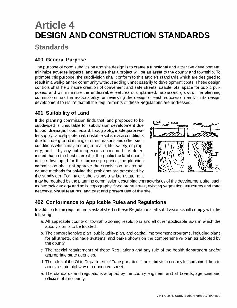
401 Suitability of LandIf the planning commission finds that land proposed to besubdivided is unsuitable for subdivision development dueto poor drainage, flood hazard, topography, inadequate wa-ter supply, landslip potential, unstable subsurface conditionsdue to underground mining or other reasons and other suchconditions which may endanger health, life, safety, or prop-erty; and, if by any public agencies concerned it is deter-mined that in the best interest of the public the land shouldnot be developed for the purpose proposed, the planningcommission shall not approve the subdivision unless ad-equate methods for solving the problems are advanced bythe subdivider. For major subdivisions a written statementmay be required by the planning commission describing characteristics of the development site, suchas bedrock geology and soils, topography, flood prone areas, existing vegetation, structures and roadnetworks, visual features, and past and present use of the site.
402 Conformance to Applicable Rules and RegulationsIn addition to the requirements established in these Regulations, all subdivisions shall comply with thefollowing:
a. All applicable county or township zoning resolutions and all other applicable laws in which thesubdivision is to be located.
b. The comprehensive plan, public utility plan, and capital improvement programs, including plansfor all streets, drainage systems, and parks shown on the comprehensive plan as adopted bythe county.
c. The special requirements of these Regulations and any rule of the health department and/orappropriate state agencies.
d. The rules of the Ohio Department of Transportation if the subdivision or any lot contained thereinabuts a state highway or connected street.
e. The standards and regulations adopted by the county engineer, and all boards, agencies andofficials of the county.
ARTICLE 4, SUBDIVISION REGULATIONS 2
403 Subdivision and Site DesignDesign of the subdivision shall take into consideration existing county, municipal and regional com-prehensive plans, and shall be based on a site analysis. To the maximum extent practicable, develop-ment shall be located to preserve the natural features of the site, to avoid areas of environmentalsensitivity, and to minimize negative impacts and alterations of natural features. The following specificareas shall be preserved as undeveloped open space, to the extent consistent with the reasonableutilization of land, and in accordance with the U.S. and Ohio Constitutions and state or federal regula-tions:
a. Unique and/or fragile areas, including wetlands, as may be defined in Section 404, FederalWater Pollution Act, as amended; and in Ohio EnvironmentalProtection Agency standards.
b. Land in the floodway as identified and mapped using the Fed-eral Emergency Management Agency’s Flood Hazard Bound-ary Maps.
c. Steep slopes in excess of fifteen (15) percent unless appropri-ate engineering measures concerning slope stability, erosion,and resident safety are taken into account.
d. Habitats of endangered wildlife, as identified on federal andstate lists.
e. Historically and culturally significant structures and sites, aslisted on the National Register of Historical Places.
f. Land located within 300 feet of an existing oil or gas well.
The development shall be laid out to avoid adversely affecting groundwater and aquifer recharge; toreduce cut and fill; to avoid unnecessary impervious cover; to prevent flooding; to provide adequateaccess to lots and sites; and, to mitigate adverse effects of noise, odor, traffic, drainage, and utilitieson neighboring properties. The placement of buildings in residential developments shall take intoconsideration topography, building height, orientation and drainage.
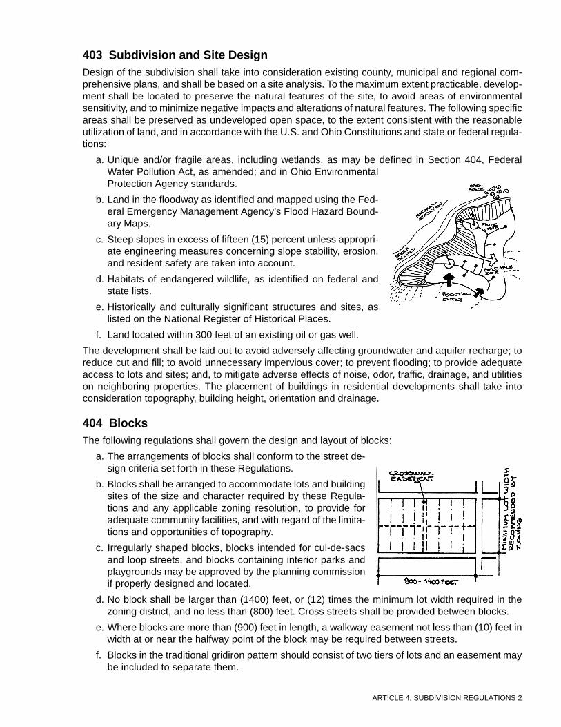
404 BlocksThe following regulations shall govern the design and layout of blocks:
a. The arrangements of blocks shall conform to the street de-sign criteria set forth in these Regulations.
b. Blocks shall be arranged to accommodate lots and buildingsites of the size and character required by these Regula-tions and any applicable zoning resolution, to provide foradequate community facilities, and with regard of the limita-tions and opportunities of topography.
c. Irregularly shaped blocks, blocks intended for cul-de-sacsand loop streets, and blocks containing interior parks andplaygrounds may be approved by the planning commissionif properly designed and located.
d. No block shall be larger than (1400) feet, or (12) times the minimum lot width required in thezoning district, and no less than (800) feet. Cross streets shall be provided between blocks.
e. Where blocks are more than (900) feet in length, a walkway easement not less than (10) feet inwidth at or near the halfway point of the block may be required between streets.
f. Blocks in the traditional gridiron pattern should consist of two tiers of lots and an easement maybe included to separate them.
ARTICLE 4, SUBDIVISION REGULATIONS 3
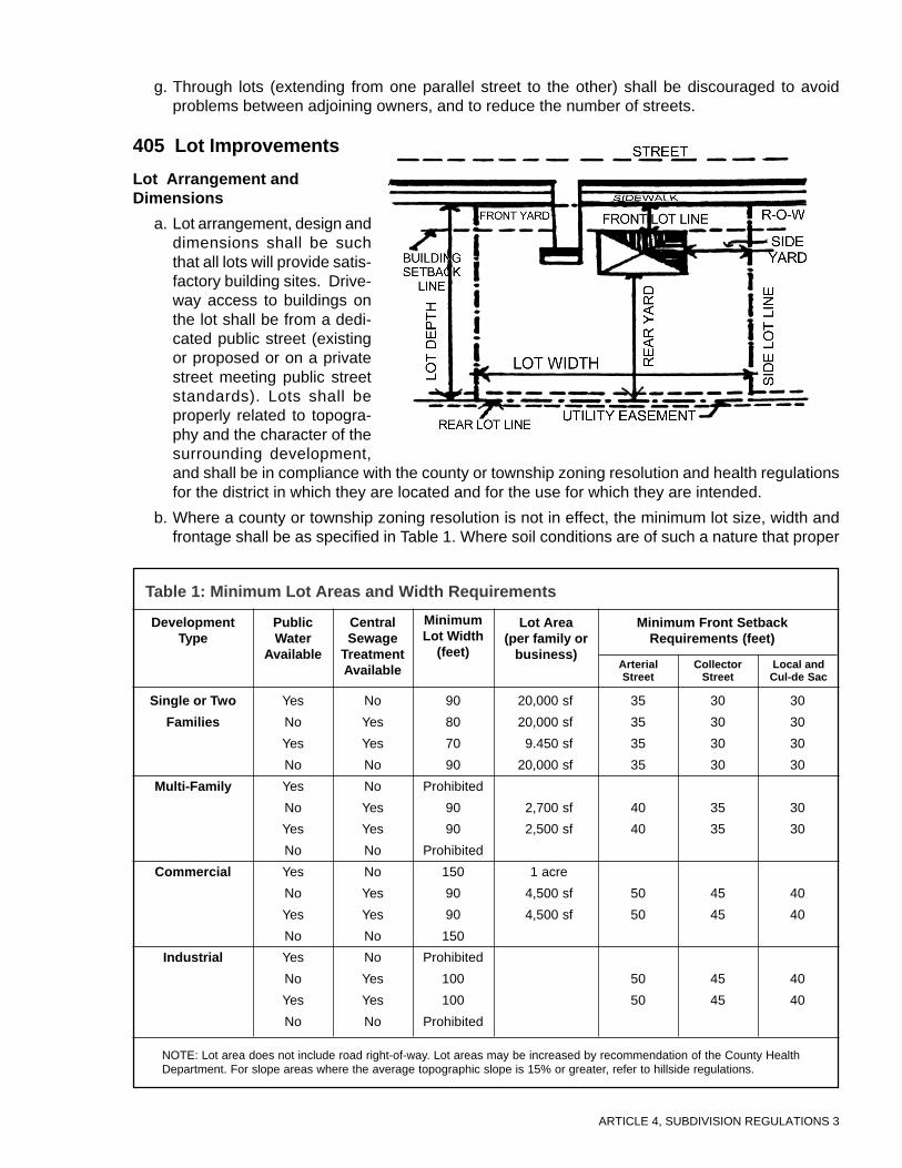
g. Through lots (extending from one parallel street to the other) shall be discouraged to avoidproblems between adjoining owners, and to reduce the number of streets.
405 Lot Improvements
Lot Arrangement andDimensions
a. Lot arrangement, design anddimensions shall be suchthat all lots will provide satis-factory building sites. Drive-way access to buildings onthe lot shall be from a dedi-cated public street (existingor proposed or on a privatestreet meeting public streetstandards). Lots shall beproperly related to topogra-phy and the character of thesurrounding development,and shall be in compliance with the county or township zoning resolution and health regulationsfor the district in which they are located and for the use for which they are intended.
b. Where a county or township zoning resolution is not in effect, the minimum lot size, width andfrontage shall be as specified in Table 1. Where soil conditions are of such a nature that proper
Table 1: Minimum Lot Areas and Width Requirements
DevelopmentType
Single or Two
Families
Multi-Family
Commercial
Industrial
PublicWater
Available
Yes
No
Yes
No
Yes
No
Yes
No
Yes
No
Yes
No
Yes
No
Yes
No
No
Yes
Yes
No
No
Yes
Yes
No
No
Yes
Yes
No
No
Yes
Yes
No
90
80
70
90
Prohibited
90
90
Prohibited
150
90
90
150
Prohibited
100
100
Prohibited
CentralSewage
TreatmentAvailable
MinimumLot Width
(feet)
Lot Area(per family or
business)
Minimum Front SetbackRequirements (feet)
ArterialStreet
CollectorStreet
Local andCul-de Sac
20,000 sf
20,000 sf
9.450 sf
20,000 sf
2,700 sf
2,500 sf
1 acre
4,500 sf
4,500 sf
35
35
35
35
40
40
50
50
50
50
30
30
30
30
35
35
45
45
45
45
30
30
30
30
30
30
40
40
40
40
NOTE: Lot area does not include road right-of-way. Lot areas may be increased by recommendation of the County HealthDepartment. For slope areas where the average topographic slope is 15% or greater, refer to hillside regulations.

ARTICLE 4, SUBDIVISION REGULATIONS 4
operation of wells and septic tanks may be impaired, the planning commission, upon recom-mendation from the health department may increase the size of any or all lots in the subdivision,or may deny approval of the subdivision.
c. Dimensions of corner lots shall be large enough to allow the erection of buildings, observing theminimum front-yard setback from both streets.
d. The maximum depth of any lot shall not be greater than four times its width.
Lot Orientation
a. Residential lots shall front on a dedicated public street (existing or proposed) or on a privatestreet meeting public street standards. All side lot lines where practicable should be at approxi-mate right angles to street lines or radial to curving street lines, unless a variation from theserules will give a better street or lot plan. Variations are permitted to accommodate barriers suchas streams and existing utility easements. However, side lot lines shall not deflect more than(30) degrees from the perpendicular in relation to street centerlines. A side lot line shall maintainthe same angle of deflection between the front lot line and the minimum building setback line asestablished by the zoning resolution or these Regulations.
b. The lot line common to the street right-of-way shall be the front line. All lots shall face the frontline and a similar line across the street. Wherever feasible, lots shall be arranged so that therear line does not abut the sideline of an adjacent lot.
Double Frontage Lots and Access to Lots
a. Double frontage and reversed frontage lots shall beavoided except where necessary to provide separationof residential development from traffic arterials or toovercome specific disadvantages of topography andorientation. Residential lots abutting arterial or collec-tor streets, where marginal access streets are not de-sirable or possible to attain, shall be designed as re-verse lots or with side lot lines parallel to the majortraffic streets. These requirements may be waived bymutual consent of the planning commission and thecounty engineer.
b. Lots may not be created by dividing land at the end ofstub streets in adjacent subdivisions, such stub streetsbeing intended to promote continuity of street systemsin adjoining subdivisions.
c. Fifty (50) feet (minimum) of additional lot depth or abuffer strip in accordance with the landscape standardsherein may be required where a residential lot in a sub-division backs up to a railroad right-of-way, a high pres-sure gasoline or natural gas line, open drainage ditch,an arterial street or interstate highway, an industrial areaor other existing land use which may have a detrimen-tal effect on the residential use of the property, andwhere no local street is provided at the rear of such lot.
406 Easementsa. Location of utility line easements within the road right-of-way shall be located outside of the
improved portion of the roadway. Utility easements may also be located along the front of line orcentered on the rear or side lot line as necessary for utility lines. Easements shall give access to
When diagonal streets cannot be avoided
When existing intersecting streets formacute-angled intersections
When future street extensions are notrequired in corners of the property

ARTICLE 4, SUBDIVISION REGULATIONS 5
every lot, park or public grounds. Such easements shall be a total of not less than twenty (20)feet wide.
b. Recommendations on the proposed layout of telephone and electric company easements shouldbe sought from all of the utility companies serving the area. It shall be the responsibility of thesubdivider to submit copies of the preliminary plan to all appropriate public utility companies.
c. Easements shall be provided for storm drainage purposes. Such easements shall conform sub-stantially with the lines of any natural water course, channels, streams or creeks which traversethe subdivision or for any new channel which is established to substitute for an existing naturalwatercourse, channel, stream or creek. Such easements shall be of sufficient width to provideadequate area for maintenance, however shall not be less than twenty (20) feet. Provisions ofan easement in no way make any political subdivision responsible for maintenance of stormwater facilities. The plat shall specify the entity or person responsible for maintenance of stormwater facilities.
d. Whenever practicable, the utilities shall be placed underground, according to the standards ofthe appropriate utility company.
e. The location of mailboxes and similar structures in the right-of-way of a public or private streetshall be constructed so as to not create a hazard to the public and shall be constructed pursuantto standards of the Ohio Department of Transportation.
407 Standards for Nonresidential Subdivisionsa. In addition to the principles and standards in these Regulations, the applicant shall demonstrate
to the satisfaction of the commission that the streets, parcels, blocks, and lot patterns proposedare specifically adapted to the uses anticipated and take into account other uses in the vicinity.
b. Proposed industrial parcels shall be suitable in area and dimension to the types of industrialdevelopment anticipated.
c. Every effort shall be made to protect adjacent residential areas from potential nuisance from aproposed commercial or industrial subdivision, including the provision of extra depth in parcelsbacking up on existing or potential residential development and provisions for a permanentlylandscaped buffer strip when necessary.
d. Blocks intended for commercial and industrial subdivisions shall be designed specifically forsuch purposes and shall include adequate provision for parking, loading and delivery services.Such blocks shall not be less than (250) feet in width and not less than (500) feet in length.
e. Lots intended for other non-residential use shall be specifically noted and designed for suchpurposes, and shall have adequate provisions for off-street parking, setbacks, and loading andunloading areas.

ARTICLE 4, SUBDIVISION REGULATIONS 6
Commentary on Article 4
400 General PurposeArticle 4 consists of standards that regulate subdivision design and improvements. These standards deal withthe arrangement and engineering of site details, buildings, roads, utilities, and landscaping to provide a wellbuilt subdivision. These standards shall be adopted based on the unique character of the site and local needs andobjectives in order to promote quality development. They are not to be used to exclude housing for moderate orlow-income persons.
401 Suitability of LandThe first step in development design is to gather and evaluate information about the project site and its sur-rounding area. Since each site is unique, the data will vary depending on the nature of the site itself, availableresources and purpose of the development.
402 Conformance to Applicable Rules and RegulationsSubdivision regulations shall be an integrated element of the planning process, in order to accomplish theirpotential role in upgrading the living environment. As an integrated element of the planning process, subdivi-sion approval must include consideration of all the community’s existing plans and standards.
403 Subdivision and Site DesignThe purpose of site design standards is to ensure that the design of new subdivisions will respect the siteenvironment, the existing patterns of development, and be an asset to the community. It is within the scope ofthese Regulations to recommend that placement of lots, buildings, and roads complement and preserve thenatural and historical features of the site. The subdivision shall protect land unsuitable for development in orderto promote public health, safety and welfare. The language, “to the maximum extent practicable” is intended toprotect developers from unreasonable restrictions that may be required by a community wishing to stop devel-opment of any kind. In residential developments, buildings are not simply scattered about a site without pur-pose, but are arranged according to an organizing concept. In contrast to conventional development, two con-cepts that have influenced the layout of subdivisions are clusters and planned unit developments. Within thesetypes of developments, lots are concentrated on the most suitable portion of the site, thus preserving naturalfeatures and reducing development, construction and maintenance cost because infrastructure is more compact.
404 BlocksThe design and layout of blocks is important in providing for proper vehicular and pedestrian travel and ad-equate building sites.
405 Lot ImprovementsThe layout of lots must be based on topographic considerations in order to minimize the amount of earthworkrequired and in order to provide for level driveway access with good sight distance from the driveway. Thelocations of good building sites is one of the key criteria for determining lot placement and size. Use of indi-vidual, home sewage systems will also be a key determinant of lot configuration. The regulations include arecommended maximum width to depth ration of 1:4; however, flexibility and a review of this requirement priorto adoption are encouraged.
Lots can front on a private street only if such street meets the requirements of these Regulations regardingconstruction standards and the ability of the residents to provide for the long-term maintenance of the street.Side lot lines should be nearly perpendicular to the street centerline to insure easy access into a driveway and toprovide for the most efficient use of space. It is important to preserve the traffic-carrying capacity of any road-way system. Exceeding the capacity by allowing too many driveway access points, particularly onto arterial and

ARTICLE 4, SUBDIVISION REGULATIONS 7
major collector streets, will have the effect of creating traffic slowdowns and dangerous conditions.
406 EasementsEstablishing the location of easements and working with utility companies early in the process is key to goodsubdivision design. It is a burden on all parties when an easement must be located “after the fact,” when asubdivision is already built, due to a planning oversight during the design phase. Underground utilities providefor an aesthetically pleasing design. Landscape screening of utility boxes and other structures must also beconsidered.
407 Standards for Nonresidential SubdivisionsCommercial and Industrial developments shall be designed according to the same principles governing thedesign of residential developments. In addition, special design requirements, such as configuration of lots,location of buildings, parking, convenient access, and loading facilities for large vehicles should be taken intoconsideration. Commercial and industrial facilities have the potential to create noise and light pollution. Thesefactors must be taken into consideration and appropriate methods found to minimize negative impacts.
ARTICLE 5, SUBDIVISION REGULATIONS 1
Article 5STREET DESIGN AND CONSTRUCTIONSTANDARDSStandards
500 GeneralThese Regulations shall control the manner in which the road system is arranged on the land to permitthe safe, efficient, and orderly movement of traffic; to meet, but not exceed, the needs of the presentand future population; to have a simple and logical pattern; to respect natural features and topogra-phy; and to present an attractive streetscape.
501 Conformity to Development Plans and ZoningNo subdivision shall be approved unless the area to be subdivided has frontage on and access froman existing street on the official thoroughfare map, or if there is no official thoroughfare map, unlesssuch street is an existing state, county, or township highway, road or a street shown upon a platapproved by the planning commission and recorded in the county recorder’s office. Such street orhighway must be suitably improved as required by these Regulations or guaranteed, with a perfor-mance bond, to be improved as required by these Regulations. In addition, no final plat of land withinan existing zoning district shall be approved unless it conforms with requirements of the zoning dis-trict.
502 Official Road Design StandardsDesign standards and required improvements to arterial streets and roads are contained in Table 2.Construction design criteria of these streets are to be determined by the county engineer when suchstreets abut or cross the proposed subdivision. Certain improvements may be waived upon recom-mendation of the county engineer and after review and approval by the planning commission. In allcases right-of-way dedications shall be required for streets leading to new subdivisions.
When developing along one side of an existing street or roadway included in the official thoroughfareplan, the subdivider shall be responsible for construction or replacement of the entire existing pave-ment, in accordance with the requirements of the county engineer.
503 Street NamesStreet name signs or numbers of a type in use throughout the county shall be erected by the subdi-vider at all intersections. Names of new streets shall not duplicate or nearly duplicate those of existingor platted streets, irrespective of the use of the suffix “street,” “avenue,” “circle,” “boulevard,” “drive,”etc., and shall be displayed at each street intersection with street signs of the type established by thecounty. When a new street is a direct extension of an existing street, the name shall remain the same.
Table 2: Street Design Standards for Arterial Roads
R/WWidth (feet)
Sidewalks(feet)
Planting Strip(feet)
Median(feet)
Pavement Width(feet)
708290
120
5555
85912
None141414
44484872

ARTICLE 5, SUBDIVISION REGULATIONS 2
Sign color shall conform with county or township requirements. Street names shall be subject to theapproval of the planning commission. The subdivider is responsible for the cost of purchasing andinstalling all signage.
504 Street and Circulation System Designa. The arrangement, character, extent, and location of all streets shall conform to the thoroughfare
plan of the county; such streets shall be considered in their relation to existing and plannedstreets, topographic conditions, public conve-nience and safety, and in their relation to theproposed uses of land to be served by suchstreets. The planning commission reservesthe right to disapprove any street plan whichdoes not represent good design or does notinsure continuity of the existing street system.
b. The road system shall be designed to servethe need of the neighborhood and to discour-age through traffic in the interior of such sub-division. Residential driveway access shall notbe permitted onto principal arterials. Majorsubdivisions shall be designed to discourageresidential driveway access onto major arte-rial and collector roadways by using accessroads. Minimizing driveway access points orcurb cuts by using access roads shall be en-couraged.
There shall be no private streets, lanes, roads orways nor any private easement used for the purpose of primary access to any subdivision, includingsubdivisions exempt from platting under Ohio Revised Code Section 711.131 unless constructed andmaintained to county road specifications and standards. The cost of maintenance of such privatestreets, roadways and easements shall be borne equitably by benefiting property owners. Properlegal steps shall be taken to guarantee the continuing maintenance of such streets, roadways andeasements.
505 Street VacationThe planning commission shall not recommend the vacation of any street dedicated to and acceptedby the public if such vacation will adversely affect the proper functioning of the existing street systemor any future street plan prepared by, or approved by, the planning commission. The procedure tovacate a street or alley may be found in Ohio Revised Code Section 5553.01.
506 Rights-of-Waya. The right-of-way shall be measured from lot line to lot line and shall be sufficiently wide to
contain the cartway, curbs, sidewalks, utilities, graded areas and shade trees, if required.
b. The right-of-way of a new street that is a continuation ofan existing street shall in no case be continued at a widthless than that of the existing street.
c. The right-of-way for roads shall be in accordance withthe major thoroughfare plan, and shall provide for fu-ture development.
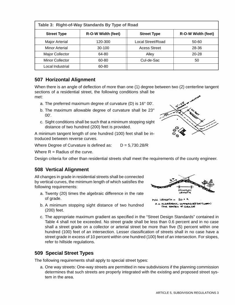
ARTICLE 5, SUBDIVISION REGULATIONS 3
507 Horizontal AlignmentWhen there is an angle of deflection of more than one (1) degree between two (2) centerline tangentsections of a residential street, the following conditions shall bemet:
a. The preferred maximum degree of curvature (D) is 16° 00'.
b. The maximum allowable degree of curvature shall be 23°00'.
c. Sight conditions shall be such that a minimum stopping sightdistance of two hundred (200) feet is provided.
A minimum tangent length of one hundred (100) feet shall be in-troduced between reverse curves.
Where Degree of Curvature is defined as: D = 5,730.28/R
Where R = Radius of the curve.
Design criteria for other than residential streets shall meet the requirements of the county engineer.
508 Vertical AlignmentAll changes in grade in residential streets shall be connectedby vertical curves, the minimum length of which satisfies thefollowing requirements:
a. Twenty (20) times the algebraic difference in the rateof grade.
b. A minimum stopping sight distance of two hundred(200) feet.
c. The appropriate maximum gradient as specified in the “Street Design Standards” contained inTable 4 shall not be exceeded. No street grade shall be less than 0.6 percent and in no caseshall a street grade on a collector or arterial street be more than five (5) percent within onehundred (100) feet of an intersection. Lesser classification of streets shall in no case have astreet grade in excess of 10 percent within one hundred (100) feet of an intersection. For slopes,refer to hillside regulations.
509 Special Street TypesThe following requirements shall apply to special street types:
a. One way streets: One-way streets are permitted in new subdivisions if the planning commissiondetermines that such streets are properly integrated with the existing and proposed street sys-tem in the area.
Major Arterial
Minor Arterial
Major Collector
Minor Collector
Local Industrial
Local Street/Road
Acess Street
Alley
Cul-de-Sac
120-300
30-100
64-80
60-80
60-80
50-60
28-36
20-28
50
Street Type R-O-W Width (feet)
Table 3: Right-of-Way Standards By Type of Road
Street Type R-O-W Width (feet)

ARTICLE 5, SUBDIVISION REGULATIONS 4
b. Permanent dead-end streets shall not be permitted. Temporary dead-end streets shall be per-mitted only as a segment of a continuing street plan subject to extension into undevelopedacreage. Temporary dead-end streets shall extend to the boundary of such undeveloped acre-age and shall be provided with an interim turnaround satisfactory to the planning commission indesign. The planning commission shall reserve the right to limit the length of such a dead-endstreet based on principles of proper planning, and the planning commission may require a streetalong the boundary between a proposed subdivision and the undeveloped acreage to providefor future development.
c. Cul-de-sac streets shall not exceed a length of onethousand (1,000) feet measured to the center of theradius of the turnaround. The terminus may be cir-cular with a minimum radius of fifty (50) feet mea-sured from a point on the street centerline. Othertermini types, such as “T’s” or vegetated islands,are acceptable and subject to review and approvalby the county engineer and planning commission.Cul-de-sacs may exceed 1,000 feet with an inter-mediate turnaround depending upon the total num-ber of lots served by the road.
d. The dedication of new half-streets shall not be permitted.If a parcel to be subdivided existsadjacent to a dedicated or platted and recorded half-width street or alley, the other half-width ofsuch street or alley falling within the proposed subdivision shall be platted, provided that in theopinion of the planning commission such right-of-way is necessary for the proper developmentof the area.
e. Where a subdivision adjoins an arterial street, a marginal access street shall be designed tocontrol access from lots fronting on it. Points of access to the arterial street shall be spaced at aminimum of thirteen hundred twenty (1320)feet. A planting strip having a minimum widthof twenty (20) feet shall be provided betweenthe pavement of the marginal access street.The minimum width of the marginal accessright-of-way shall be fifty (50) feet. In addi-tion, the planning commission may also re-quire the provision of buffer planting strips,the platting of loop streets or cul-de-sacs con-nected to such parallel streets, or any com-bination thereof.
T-JunctionStraight Street

ARTICLE 5, SUBDIVISION REGULATIONS 5
f. Easements or reserve strips controlling access to streets shall be prohibited except where deemednecessary by the planning commission and where their control is definitely placed with the county.
g. In subdividing land along existing streets or roads and within a proposed subdivision, provisionsfor the dedication of land for one or more access streets to undeveloped land not fronting on anexisting street or road shall be incorporated. Said access streets shall be spaced not less thaneight hundred (800) feet, nor more than one thou-sand four hundred (1,400) feet apart.
h. Alleys may be approved in residential subdivisionswhen justified by subdivision street design, to pro-vide vehicular access to parking areas. Alleys maybe approved in commercial and industrial subdivisionsif no other provisions can be made for adequate ser-vice access. The minimum widths for alleys shall betwenty (20) feet and they shall be dedicated to thepublic. Alley intersections, sharp changes in align-ment, and dead-ends shall not be permitted unlessextreme conditions would warrant.
510 Street Design Standards for all Streets Except Cul-de-Sacsand Loop-Type Local Streets
The design and improvement standards contained in Table 4 are minimums for all local streets andcollector streets, except cul-de-sacs and loop-type streets, in residential subdivisions.
Right-of-way (ft.) 50* 50* 60 60 60 60
Pavement Width 24 24 24 28 28 28
Minimum Stopping Sight 200 200 200 200 200 200Distance (feet)
Maximum Grade 4% 8% 15% 4% 8% 15%
Maximum Spacing -- -- -- 1320 1320 1320when intersected with an arterial (ft)
Maximum Center Line Radiusof Streets with an angle of turn of:
(1) Between 80 and 100 50 50 50
(2) Less than 80 or more than 100 200 200 200
Minimum Center Line Radius — — — 350 350 350
*A utility easement ten (10) feet in width may be required along each side of the street right-of-way for these streets.
LEVEL COLLECTOR STREET
Table 4: Street Design Standards for Local and Collector Streets
Terrain Classification Level Rolling Level Rolling HillyHilly
Note: Exceptions to the standards contained in this table are permitted under certain conditions for large lots. Hillsidelots with grades of more than 15% are also subject to exceptions as proved under Article 10, Hillside Regulations.
Note: Exceptions to the standards contained in this table are permitted under certain conditions for large lots. Hillsidelots with grades of more than 15% are also subject to exceptions as provided under Article 10, hillside regulations.

ARTICLE 5, SUBDIVISION REGULATIONS 6
Right-of-way (ft.)
Pavement Width
Minimum Stopping SightDistance (feet)
Maximum Grade
Maximum cul-de-sac length
Maximum cul-de-sac radius (row)
Maximum cul-de-sac radius(pavement)
Maximum Center Line Radiusof Streets with an angle of turn of:
(1) Between 80 and 100
(2) Less than 80 or more than 100
*A utility easement ten (10) feet in width may be required along each side of the street right-of-way for these streets.
Table 5: Street Design Standards for Cul-de-Sacs and Loop-Type Streets
Terrain Classification Level Rolling Hilly
25-50*
22
250
4%
1000
35
24
50
200
50*
22
200
8%
1000
50
40
50
200
50*
22
200
8%
1000
50
40
50
200
Maximum Approach Speed (mph)
Clear Sight Distance (ft, lengthalong each approach leg)
Vertical Alignment with intersection
Minimum Angle of IntersectionStreets
Minimum Curb Radius (ft)
a. local-local
b. local-collector
c. collector-collector
d. collector, marginal access-arterial
Minimum Centerline Offset ofadjacent intersection (ft)
a. local-local
b. local-collector
c. collector-collector
d. collector, marginal access-arterial
*This should be considered an absolute minimum.
Table 6: Intersection Design Standards
Terrain Classification Level Rolling Hilly
25
90
crown
25
90
5% maximum
25
70
5% maximum
20 - all classes
30 - all classes
35 - all classes
40 - all classes
60* degrees
150 - all classes
150 - all classes
200 - all classes
1320 - all classes
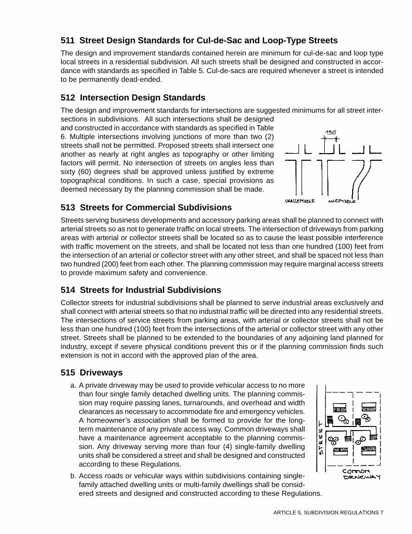
ARTICLE 5, SUBDIVISION REGULATIONS 7
511 Street Design Standards for Cul-de-Sac and Loop-Type StreetsThe design and improvement standards contained herein are minimum for cul-de-sac and loop typelocal streets in a residential subdivision. All such streets shall be designed and constructed in accor-dance with standards as specified in Table 5. Cul-de-sacs are required whenever a street is intendedto be permanently dead-ended.
512 Intersection Design StandardsThe design and improvement standards for intersections are suggested minimums for all street inter-sections in subdivisions. All such intersections shall be designedand constructed in accordance with standards as specified in Table6. Multiple intersections involving junctions of more than two (2)streets shall not be permitted. Proposed streets shall intersect oneanother as nearly at right angles as topography or other limitingfactors will permit. No intersection of streets on angles less thansixty (60) degrees shall be approved unless justified by extremetopographical conditions. In such a case, special provisions asdeemed necessary by the planning commission shall be made.
513 Streets for Commercial SubdivisionsStreets serving business developments and accessory parking areas shall be planned to connect witharterial streets so as not to generate traffic on local streets. The intersection of driveways from parkingareas with arterial or collector streets shall be located so as to cause the least possible interferencewith traffic movement on the streets, and shall be located not less than one hundred (100) feet fromthe intersection of an arterial or collector street with any other street, and shall be spaced not less thantwo hundred (200) feet from each other. The planning commission may require marginal access streetsto provide maximum safety and convenience.
514 Streets for Industrial SubdivisionsCollector streets for industrial subdivisions shall be planned to serve industrial areas exclusively andshall connect with arterial streets so that no industrial traffic will be directed into any residential streets.The intersections of service streets from parking areas, with arterial or collector streets shall not beless than one hundred (100) feet from the intersections of the arterial or collector street with any otherstreet. Streets shall be planned to be extended to the boundaries of any adjoining land planned forindustry, except if severe physical conditions prevent this or if the planning commission finds suchextension is not in accord with the approved plan of the area.
515 Drivewaysa. A private driveway may be used to provide vehicular access to no more
than four single family detached dwelling units. The planning commis-sion may require passing lanes, turnarounds, and overhead and widthclearances as necessary to accommodate fire and emergency vehicles.A homeowner’s association shall be formed to provide for the long-term maintenance of any private access way. Common driveways shallhave a maintenance agreement acceptable to the planning commis-sion. Any driveway serving more than four (4) single-family dwellingunits shall be considered a street and shall be designed and constructedaccording to these Regulations.
b. Access roads or vehicular ways within subdivisions containing single-family attached dwelling units or multi-family dwellings shall be consid-ered streets and designed and constructed according to these Regulations.
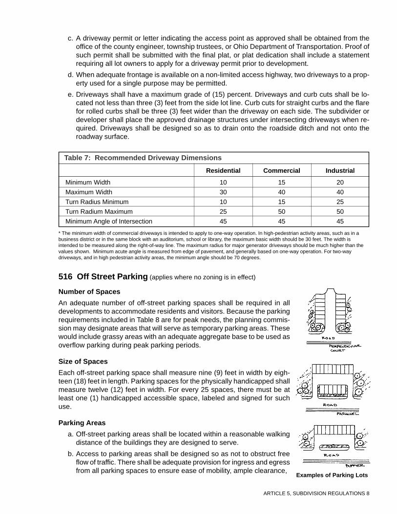
ARTICLE 5, SUBDIVISION REGULATIONS 8
516 Off Street Parking (applies where no zoning is in effect)
Number of Spaces
An adequate number of off-street parking spaces shall be required in alldevelopments to accommodate residents and visitors. Because the parkingrequirements included in Table 8 are for peak needs, the planning commis-sion may designate areas that will serve as temporary parking areas. Thesewould include grassy areas with an adequate aggregate base to be used asoverflow parking during peak parking periods.
Size of Spaces
Each off-street parking space shall measure nine (9) feet in width by eigh-teen (18) feet in length. Parking spaces for the physically handicapped shallmeasure twelve (12) feet in width. For every 25 spaces, there must be atleast one (1) handicapped accessible space, labeled and signed for suchuse.
Parking Areas
a. Off-street parking areas shall be located within a reasonable walkingdistance of the buildings they are designed to serve.
b. Access to parking areas shall be designed so as not to obstruct freeflow of traffic. There shall be adequate provision for ingress and egressfrom all parking spaces to ensure ease of mobility, ample clearance,
c. A driveway permit or letter indicating the access point as approved shall be obtained from theoffice of the county engineer, township trustees, or Ohio Department of Transportation. Proof ofsuch permit shall be submitted with the final plat, or plat dedication shall include a statementrequiring all lot owners to apply for a driveway permit prior to development.
d. When adequate frontage is available on a non-limited access highway, two driveways to a prop-erty used for a single purpose may be permitted.
e. Driveways shall have a maximum grade of (15) percent. Driveways and curb cuts shall be lo-cated not less than three (3) feet from the side lot line. Curb cuts for straight curbs and the flarefor rolled curbs shall be three (3) feet wider than the driveway on each side. The subdivider ordeveloper shall place the approved drainage structures under intersecting driveways when re-quired. Driveways shall be designed so as to drain onto the roadside ditch and not onto theroadway surface.
Table 7: Recommended Driveway Dimensions
Residential Commercial Industrial
Minimum Width
Maximum Width
Turn Radius Minimum
Turn Radium Maximum
Minimum Angle of Intersection
10
30
10
25
45
15
40
15
50
45
20
40
25
50
45
Examples of Parking Lots
* The minimum width of commercial driveways is intended to apply to one-way operation. In high-pedestrian activity areas, such as in abusiness district or in the same block with an auditorium, school or library, the maximum basic width should be 30 feet. The width isintended to be measured along the right-of-way line. The maximum radius for major generator driveways should be much higher than thevalues shown. Minimum acute angle is measured from edge of pavement, and generally based on one-way operation. For two-waydriveways, and in high pedestrian activity areas, the minimum angle should be 70 degrees.

ARTICLE 5, SUBDIVISION REGULATIONS 9
One/Two Family Dwellings 2 spaces/DU.
Townhouses and Multiple Family 2 spaces/DU.
Mobile Homes 2 spaces/unit.
Office Uses 2 spaces plus 1 space for each 200 sq. ft. of usablefloor area.
Office Uses 1 space for each 100 sq. ft. of usable floor area.
Industrial Uses 1 space for employee in the largest working shift.
Churches and Temples 1 space for each 3 seats.
School 2 per classroom, but not less than 1 per teacherand staff
Restaurant 1 per 3 seats
Fast-Food Establishment 1 per 30 sq. ft. of usable floor area
Retail Store 1 per 200 sq. ft. of usable floor area
Shopping Center Under 400,000 sq. ft. 4 per 1,000 sq. ft. of usable floor area
Shopping Center 400,000-599,999 sq.ft. 4.5 per 1,000 sq. ft. of usable floor area
Shopping Center 600,000+ sq. ft. 5 per 1,000 sq. ft. of usable floor area
Medical Center 1 per 250 sq. ft. of usable floor area
Note: Where and if these standards conflict with applicable zoning regulations, the zoning regulation’sstandards shall apply.
Table 8: Recommended Parking Requirements
Type of Uses Off-Street Parking Requirements
and emergency vehicle and pedestrian access.
c. Parking lots containing ten (10) or more spaces, shall be planted with at least one (1) tree pereight (8) spaces, no smaller than 2" caliper (tree trunk diameter at chest height).
d. Parking areas shall be screened along lot lines bordering institutional or residential uses andalong streets. Native trees and shrubs shall be planted wherever possible.
e. The width of all aisles providing direct access to individual parking stalls shall be in accordancewith the requirements specified below. Only one-way traffic shall be permitted in aisles servingsingle-row parking spaces placed at an angle other than ninety degrees.
517 Sidewalks and Graded Areasa. Sidewalks may be required in all subdivisions. Where the average lot line frontage is 100 feet or
less, sidewalks may be required on both sides of the street. Where the average lot line frontageis greater than 100 feet, sidewalks may only be required on one side of the street. Where theaverage lot line frontage is greater than 150 feet, sidewalks may not be required.
b. In conventional developments, sidewalks shall be placed in the right-of-way, parallel to the street,unless an exception has been permitted to preserve topographical or natural features or toprovide visual interest, or unless the applicant shows that an alternative pedestrian systemprovides safe and convenient circulation. In commercial and in high-density residential areas,sidewalks may abut the curb.

ARTICLE 5, SUBDIVISION REGULATIONS 10
c. Pedestrian-way easements ten (10) feet wide may be required by the planning commissionthrough the center of blocks to provide circulation or access to schools, playgrounds, shoppingor other community facilities.
d. Sidewalks shall measure four (4) feet in width; wider widthsmay be necessary near pedestrian generators and em-ployment centers. Where sidewalks abut the curb andparked cars overhang the sidewalk, widths shall be five(5) feet. The width of graded areas shall be the same asfor sidewalks.
e. Sidewalks and graded areas shall be constructed accord-ing to the specifications set forth in these Regulations.
f. Public sidewalks may be required for industrial lots, sub-ject to the approval of the planning commission.
518 Street and Walkway LightingThe planning commission may require the subdivider to install street lights in accordance with stan-dards and specifications of the county engineer, with consultation provided by the local electric utilitycompany, in each residential subdivision which contains a majority of lots with an individual lot width ofone hundred (100) feet or less at the front property line. Such lights shall be located at each streetintersection within the subdivision and at other locations deemed necessary by the county engineer.Streetlights shall be designed, with appropriate lamps and reflectors, to minimize light pollution.
519 Monuments, Markers, and PinsMonuments shall be set at all subdivision corners and iron pins at lot corners. The county engineermay require other monuments or iron pins to be set in the subdivision. For lot corners, reinforcing bars5/8” x 30” are acceptable. Other types of markers may be used if approved by the county engineer.Subdivision corner and benchmark monuments shall be encased with concrete at least 6” in diameterand 30” in depth.
All monuments and iron pins shall be identified on the final plat and shall be in place at the time theroads and other improvements are inspected for acceptance by the planning commission and countyengineer.
520 Culverts and Bridgesa. Where natural drainage channels intersect any street right-of-way, it shall be the responsibility
of the subdivider to have satisfactory bridges and/or culverts constructed. Where culverts arerequired, minimum requirements shall be observed as follows:
b. All culverts shall extend for an adequate distance to accommodate the required roadway em-bankment slopes. The cover over the culvert and its capacity shall be determined by thedeveloper’s professional engineer and approved by the county engineer. The minimum diam-eter of the culvert pipe shall be twelve (12) inches. Depending on the existing drainage condi-tions, head walls may be required. Where driveway culverts are wholly or partially in the streetright-of-way, they shall have a minimum length of twenty (20) feet and minimum diameter oftwelve (12) inches. The driveway culverts shall be laid so as to maintain the flow lines of theditch or gutter.
521 Street ImprovementsAll streets and thoroughfares shall be graded to their full width, including side slopes, and improved inconformance with the standards given or referred to in these Regulations. These standards are con-sidered minimum and are subject to change where deemed necessary. All materials and construction
ARTICLE 5, SUBDIVISION REGULATIONS 11
procedures shall be in accordance with the current Construction and Materials Specifications of theState of Ohio Department of Transportation or the specifications on file in the county engineers office,whichever are more stringent.
522 Street WidthMinimum street pavement widths shall conform to the standards of these Regulations. Where pave-ment widths greater than those specified are deemed necessary by the county engineer and ap-proved by the planning commission, the county shall bear the extra cost of providing the width beyondthe requirements of these Regulations.
523 Street Subgradea. The subgrade shall be free of sod, vegetative or organic matter, soft clay, and objectionable
materials for a depth of at least two (2) feet below the finish surface.
b. The subgrade shall be properly rolled, shaped, and compacted in accordance with the State ofOhio Department of Transportation Specifications. All soft areas shall be removed and replacedwith suitable material to achieve the required approval. Backfills over sewers, culverts and un-derground utilities in the roadway shall also meet the specifications in ODOT’s Construction andMaterial Specifications.
c. Sub-base grade tolerance shall be no more than one (1) inch in sixteen (16) feet, and shall besubject to the approval of the county engineer.
d. Where granular subbase is not a part of the pavement design, and rock, shale or coal is encoun-tered, the subgrade shall be excavated to a depth of 2 feet below the surface of the subgrade forthe cross section width of the roadway between points 1 foot beyond the shoulders. The addi-tional excavation shall be filled with suitable embankment material.
e. Where granular subbase is a part of the pavement design, and rock, shale or coal is encoun-tered, the subgrade shall be excavated to a depth of 18 inches below the subbase for the crosssection width of the roadway between points 1 foot beyond the shoulders. The additional exca-vation shall be filled with suitable embankment material.
f. Approval of the sub-grade must be obtained from the county engineer prior to the application ofthe base course.
524 Street Base CourseThe developer has the option of using any of the following base courses, based on recommendationsof the county engineer as to soil and traffic conditions: aggregate, bituminous aggregate, asphaltconcrete, or equally suitable base course. Thickness shall be determined by the county engineer, andapproved by the planning commission, based upon the physical properties of the base course usedand the physical properties of the roadbed.
525 Street Surface CourseUpon the expiration of the established maintenance period for the base course, the surface courseshall be constructed using either asphalt concrete, bituminous mix or portland concrete cement. Spe-cific material and thickness recommendations shall be determined by the county engineer basedupon traffic conditions.
The planning commission may recommend to the board of county commissioners that the surfacecourse requirements be waived in cases where streets within a proposed subdivision plat connect toa public road whose surface is of lesser material than that required by these Regulations and whereno specific plan, within two (2) years of approval of final plat, exists for upgrading said public roadsurface. Prior to making such a recommendation, the planning commission shall notify the board oftownship trustees who may comment within 20 days. Said comments shall accompany any recom-

ARTICLE 5, SUBDIVISION REGULATIONS 12
mendation to the county commissioners. However, streets within the proposed subdivision shall meetor exceed the surface material of said public road. Waiver may not be granted where the proposeddensity meets or exceeds medium-low density residential as defined in these Regulations.
526 Portland Cement Concrete PavementIf the subdivider elects to construct streets totally out of portland cement concrete or if such pavementis required by the county engineer, thicknesses of six (6) inches for local and collector streets andseven (7) inches for arterial, commercial and industrial streets shall be required, and shall meet thecurrent Plain Portland Cement Concrete pavement specifications of the Ohio Department of Trans-portation. The planning commission may require pavements of greater thickness, upon the recom-mendation of the county engineer, based upon his or her evaluation of the subgrade, traffic, andwheel load conditions.
527 Full-Depth Asphalt PavementIf streets are to be constructed out of “full-depth” asphalt, an asphalt pavement in which asphalt-aggregate mixtures are used for all courses above the subgrade may be necessary. The county engi-neer will determine pavement thicknesses. For local streets pavements may vary from four (4) toseven (7) inches depending upon subgrade conditions. For collector streets, pavements may varyfrom five (5) to nine (9) inches, and for arterial and industrial streets from six (6) to eleven (11) inches,depending upon the engineer’s recommendation.
528 Street Curbs and GuttersThe requirements for curbs and gutters will vary according to the character of the area and the densityof development. In areas with substantial flash flooding or heavy rain run-off, curbs shall be requiredon all streets designed for areas where the existing or anticipated residential density of the areasurrounding the proposed subdivision equals or exceeds three (3) dwelling units per net acre.
In commercial developments, or where other similar intensive urban uses exist or are anticipated,curbs shall be required.
Where curbs exist on abutting properties, their extension shall be required throughout the proposedsubdivision. Curbs and gutters shall be constructed in conformance with the current Constructionsand Material Specifications of the State of Ohio Department of Transportation.
529 Open Ditches and SlopesOpen ditch construction for roadside drainage shall be permitted in low density areas, and constructedaccording to Ohio Department of Transportation specifications. Minimum depth of ditches shall be two(2) feet below the edge of pavement, and one (1) foot minimum at top of hill and toe of bank. Allditches shall be protected against erosion. Curlex or approved equal shall be used in ditches up to2.5%. Sod or Rip-Rap shall be used in the bottom and sides of ditches up to 5%, and tile or pavedgutters shall be used in ditches over 5%.
530 DrivewaysDriveways should have a maximum grade of (15) percent. Driveways and curb cuts shall be locatednot less than three (3) feet from the side lot line. Curb cuts for straight curbs and the flare for rolledcurbs shall be three (3) feet wider than the driveway on each side. The subdivider or developer shallplace the approved drainage structures under intersecting roads, drives, lanes or property entrancesand at other locations where required. Driveways shall be designed so as to drain into the roadsideditch and not into the roadway surface.

ARTICLE 5, SUBDIVISION REGULATIONS 13
531 Street Construction StandardsStreet construction design is based upon the California Bearing Ratio (C.B.R.) value of the soil subgrade.Where more than one soil type of varying CBR value occurs on the proposed street, design shall bemade on the basis of the lowest CBR. While actual on-site testing is recognized as a proper methodof determining CBR values, the use of soil types may be utilized in lieu of on-site testing as a satisfac-tory substitute. For purpose of street construction standards, Table 9 shows three (3) classifications ofsoil with its engineering design calculation.
Aggregate Base
Deep Strength
Concrete Base
Concrete Pavement
304
301
404
301
402
404
305
404
452
Asphalt
6"
3"
5"
11/2"
6"
11/4"
6"
C.B.R. 4 75 4 75 4 75 4 75
Local Street (5) Collector Street (10) Minor Arterial Major Arterial& Industrial (75)
Table 9: Minimum Pavement Composition (thickness expressed in inches)
6"
3"
41/2"
11/2"
6"
11/4"
6"
6"
3"
41/2"
11/2"
6"
11/4"
6"
3"
4"
11/2"
6"
11/2"
6"
11/4"
6"
3"
3"
11/2"
41/2"
11/2"
6"
11/4"
6"
4"
3"
11/2"
41/2"
11/2"
6"
11/4"
6"
6"
11/4"
11/4"
6"
11/2"
7"
51/2"
11/4"
11/4"
6"
11/4"
7"
41/2"
11/4"
11/4"
6"
11/2"
7"
7"
11/2"
11/2"
6"
11/2"
7"
6"
11/2"
11/2"
6"
11/2"
7"
6"
11/2"
11/2"
6"
11/2"
7"
C.B.R. = California Bearing Ratio ( a measure of soil-bearing capacity • 301 = Bitumious aggregate base • 304 = Aggregate base •305 = Portland cement concrete base (5.5 bag mix) • 402 = Asphalt concrete • 404 = Asphalt concrete • 407 = Tack coat (RS-1) •408 = Prime coat (RC-30, MC-70, RT-2, or RS-2) • 452 = Plain Portland cement concrete pavement (6.5 bag mix)
Note: The number in parentheses is the design traffic number and is the “n” number of 18,000 lb. equivalent loads per day.When it is possible this loading will be exceeded, the county engineer may elect to change th roadway design specification. Allmonuments and iron pins shall be identified on the final plat, and shall be in place at the time the roads and other improve-ments are inspected for acceptance by the planning commission and county engineer.

ARTICLE 5, SUBDIVISION REGULATIONS 14
Commentary on Article 5
500 GeneralSection 407 of these Regulations deals with requirements for an adequate circulation system. A subdivisionmust have access to an existing or planned major road, and all lots within the subdivision must have at least oneboundary adjacent to a public street or road, except that private roads are permitted if they meet the constructionand maintenance standards as provided in these Regulations. The circulation system shall be related to majorthoroughfare plans, and shall follow the pattern of existing streets or roads. The circulation system designstandards are intended to promote safety, flexibility, and design based on function; and it is not the intent of thisarticle to take away from the design engineer any responsibility for the technical adequacy of the design or anyfreedom to use his or her engineering judgment and discretion. The county engineer, at any time during designor construction, shall have the authority to modify any engineering or construction detail, whenever required forthe protection of the public interest.
501 Conformity to Development Plans and ZoningAs soon as the preliminary plan is officially filed for review, copies should be distributed to any officials havingjurisdiction over proposed streets and rights-of-way so that they have ample time for review. Final plats shall notbe approved until all improvements are constructed or until a guarantee for the improvements is approved by theplanning commission. The cost of improvements will be provided by a professional engineer and will be submit-ted with the detailed engineering plans and specifications for improvements.
502 Official Thoroughfare Design StandardsThe arrangement, character, extent, width, grade, construction and location of all streets shall conform to thestandards herein set forth, and construction shall be done in accordance with the most current editions of theOhio Department of Transportation Construction and Material Specifications, the Ohio Department of Trans-portation Location and Design Manual, and the standards of the American Association of State Highway Trans-portation Officials.
503 Street NamesStreet sign erection is the responsibility of the subdivider and costs of such are to be included in the postedguarantee for construction of improvements.
504 Street and Circulation System DesignAccess control of the major thoroughfares shall be taken into consideration in the design of a subdivision plat.The Ohio Revised Code does not provide clear, formal, legal authority to regulate the number, location, ordesign of access driveways to private property from major thoroughfares or public roads. The planning commis-sion may discuss and negotiate with the subdivider the most appropriate design, in order to protect the interestof the general public.
505 Street VacationConsidering the difficulty involved with acquiring property for rights-of-way, local governments must giveserious consideration to any proposals for right-of-way vacation.
506 Rights-of-WaySince excessive right-of-way requirements raise the cost of development, they shall be the minimum necessaryto contain all street components. Efforts are being made to reduce right-of-way and pavement width require-ments on local streets since narrower local streets help reduce traffic speed and provide a more aestheticallypleasing neighborhood.

ARTICLE 5, SUBDIVISION REGULATIONS 15
507 Horizontal AlignmentThese standards insure that the roadway will not have curves that are too sharp or that reduce sight distancebelow acceptable standards.
508 Vertical AlignmentThese standards insure that roadways are not too steep but also that they have a minimal slope to insure adequatedrainage. It is important that intersections be designed so that they have minimal slope for safe stopping andstartup, particularly in icy or wet conditions.
509 Special Street TypesTemporary dead-end streets at subdivision borders insure that adjoining property will have access, an importantplanning issue easily overlooked, especially in areas not experiencing rapid growth.
Cul-de-sacs interrupt the pattern of connecting streets and provide for inefficient service delivery. Cul-de-sacsshould include stubs extending to adjoining parcels in locations where future connections will be possible. Cul-de-sac maximum lengths are provided to insure that not too many homes (on the cul-de-sac) access a collectorstreet at one point. Planning commissions must be prepared to vary this requirement for cul-de-sacs containinglarge lots and few homes. Planners and engineers may consider turnarounds at several points along a cul-de-sac.If a cul-de-sac is too long, there may be problems with fire equipment access.
Controlling access onto arterial and major collector streets is a growing concern as new development has ham-pered the traffic carrying capacity of these streets with too many access points resulting in inefficient trafficflow.
513 Streets for Commercial SubdivisionsAdequate spacing between driveway access points is important to prevent traffic backups and to maintain trafficflow. A minimum driveway/intersection spacing distance is established to prevent intersection traffic from backingup and blocking the driveway access onto the roadway.
514 Streets for Industrial SubdivisionsMinimum distances between service streets provide for maintenance of traffic flow.
515 DrivewaysMaintenance provisions for private driveways are important and shall be in writing and a part of the final platapproval.
516 Off-Street ParkingThese standards should be used as a guideline in determining the parking requirements. Parking requirementswill vary according to household characteristics, availability of mass transit, urban versus rural locations, andamount of existing parking. Where the total number of off-street parking spaces is not immediately required fora particular use, the planning commission may allow the subdivider to complete only a portion of the requiredspace, in order to allow cost savings and decrease water runoff.
517 Sidewalks and Graded AreasThe elimination of unnecessary sidewalks is a way of reducing development cost. In low-density developmentswith large frontages, sidewalks are less important than in high-density developments with narrow frontages.
518 Street and Walkway LightingLight pollution is light that escapes beyond what is needed, creating unpleasant areas due to glare or an inability

ARTICLE 5, SUBDIVISION REGULATIONS 16
to enjoy night skies. Light pollution is a growing problem in rapidly developing areas. Good lighting design willdirect light to where it is needed and away from where it is not needed.
519 Culverts and BridgesAll drainage structures shall be designed by a professional engineer and their construction costs included in thecost of subdivision improvements. The amount of the improvements guarantee will include drainage structurecosts.
Where driveway culverts are wholly or partially in the street right-of-way, they shall have a minimum length oftwenty (20) feet and minimum diameter of twelve (12) inches. Driveway culverts shall be placed so as tomaintain the flow lines of the ditch or gutter.

ARTICLE 6, SUBDIVISION REGULATIONS 1
Article 6UTILITY DESIGN AND CONSTRUCTIONSTANDARDSStandards
600 GeneralA professional engineer, licensed in Ohio, shall design any plans for public water supply, stormwaterand wastewater facilities.
601 Water Supplya. Where a public water supply is reasonably accessible or required because of groundwater pol-
lution problems, the subdivision shall be provided with a complete water distribution systemincluding a connection for each lot. Appropriately spaced fire hydrants may be required by theplanning commission. Public water distribution and public well systems shall meet the require-ments of the Ohio Environmental Protection Agency, as cited in the Ohio Revised Code.
b. Where public water supply is not available, as determined by the planning commission and thecounty health department, or not required, the subdivider shall supply acceptable evidence ofthe availability of water. The subdivider may be required to drill one (1) or more test wells in thearea to be platted. Individual private wells shall be located at least fifteen (15) feet from propertylines; fifty (50) feet from all septic tanks; fifty (50) feet from all tile fields and other sewagefacilities; fifteen (15) feet from all sewer lines; and shall not be located within any areas offlooding. As a precaution against seepage, a watertight seal shall be provided around the wellcasing. If no zoning is in effect, the minimum lot area requirements of these Regulations shallapply. In all cases where it has been determined that individual water supplies from private wellsare not feasible, a public water distribution system shall be required.
c. When a public water main is accessible, thedeveloper shall install adequate water facili-ties subject to the specifications of the OhioEnvironmental Protection Agency and thecounty health department. Depending on thenumber of housing units, residential subdivi-sions shall be connected to an existing publicor community water supply system if suchservice is available within the distances de-fined in Table 7.
For developments with more than 15 units and located within one (1) mile of an existing public orcommunity water system, adequate justification shall be provided as to why they shall not pro-vide a connection to such water supply system. For developments with more than 15 units andlocated more than one mile from an existing system, the water supply system strategy shall bedetermined on a case-by-case basis taking into consideration density of the development, costs,groundwater availability and quality.
d. Private wells and other water distribution systems may be accepted for maintenance and opera-tion by the county sanitary engineer if the ownership is vested to the county and if the waterdistribution system has been constructed according to the specifications and approved by thesanitary engineer.
Size of Development Distance
1 Unit 200 Feet
2 Units 400 Feet
3 Units 600 Feet
4 Units 800 Feet
5-15 Units 1,000 Feet
Table 10: Water Supply Extensions

ARTICLE 6, SUBDIVISION REGULATIONS 2
602 Fire Protection
a. Fire hydrants with two and one half (2 1/2) inch outlets and one (1) large pumping connectionshall be provided by the subdivider in all subdivisions with adequate public water supplies.
b. Hydrants shall be located between property lines and curbs with all outlets facing or parallel tothe street. Hydrants shall be placed at the corners of all blocks and at midblock for blocksexceeding eight hundred (800) feet in length. Hydrants shall also be required at the entranceand end of all cul-de-sacs exceeding four hundred (400) feet in length.
c. Hydrants shall be spaced to provide necessary fire flow. The average area per hydrant shall notexceed 120,000 square feet. In addition, hydrants shall be spaced so that each residence shallbe within 600 feet of a hydrant.
d. A hydrant shall be located at all low points and at all high points with adequate means of drain-age provided.
e. The type of hydrant and control valves and the location of the hydrant shall be approved by thefire chief or person responsible for the fire protection for political subdivision in which the plat islocated.
f. The minimum size of any water line serving any hydrant shall not be less than six (6) inches indiameter and shall be on circulating water lines. The size and location of water lines shall beapproved by the county engineer, the fire chief, or person responsible for the fire protection.
g. Where no public water supply is available, the planning commission may require fire ponds withdry hydrants.
603 Sanitary Sewers
a. Where an adequate public sanitary sewer system is reasonably accessible in the determinationof the planning commission, public sanitary sewers shall be installed to adequately serve alllots, including lateral connections to the public system. Public sewer system extensions shallmeet the requirements of the Ohio Environmental Protection Agency and county standards.Combinations of sanitary sewers and storm sewers shall be prohibited.
b. Where a public sanitary sewer system is not reasonably accessible, the subdivider may providea central treatment plant for the subdivision, provided that such central treatment plant is in-stalled in accordance with state and county health department requirements. Lots may be servedby individual disposal systems only with approval of appropriate state and county health offi-cials. Where the installation of individual disposal systems is considered, the absorptive abilityof the soil, surface drainage, ground water level and topography shall be the criteria used fordetermining whether or not the installation of individual systems is permissible.
c. When individual, on-lot sewage systems are approved, each lot so served shall be of a size andshape to accommodate the necessary length of a leach field at a safe distance from and at alower elevation than the proposed building(s). Such lot size and shape shall conform to therequirements of the zoning district in which they are located. If no zoning is in effect, the stan-dards set forth in these Regulations shall be met.
d. At least one (1) percolation test shall be located in close proximity to the proposed individualsewage disposal unit, numbered and with its location shown on the preliminary plan. All perco-lation tests shall be performed in accordance with the requirements of the planning commissionand the county health department. Where the installation of individual disposal units is consid-ered and where the average natural ground slope exceeds ten (10) percent, the installation of astep-up disposal system may be required subject to specifications by the county health depart-ment.
e. Depending on the number of housing units, residential subdivisions shall be connected to an

ARTICLE 6, SUBDIVISION REGULATIONS 3
8 0.60
10 0.44
12 0.36
15 0.28
18 0.24
21 0.20
24 0.16
existing public sanitary sewer system if publicservice is available within the distances definedin Table 11 (right).
f. For developments with more than 15 units andlocated within one mile of an existing public sani-tary sewer system, adequate justification shallbe provided as to why they should not provide aconnection to the existing public sewer system.
604 Design Criteria for Sanitary SewersThese design criteria are not intended to cover extraordinary situations. Deviations will beallowed and may be required in those instances when considered justified by the countysanitary engineer.
a. Design Factors: Sewer capacities shall be adequate to handle the anticipatedmaximum hourly quantity of sewage and industrial waste together with an adequateallowance for infiltration and other extraneous flow. Sewers shall be designed forthe total tributary area using the criteria in Table 12.
Size of Development Distance
1 Unit 200 Feet
2 Units 400 Feet
3 Units 600 Feet
4 Units 800 Feet
5-15 Units 1,000 Feet
Table 11: Sanitary Sewer Extensions
Flows
0.2 c.f.s./acre
0.2 c.f.s./acre0.2 c.f.s./acre
0.2 c.f.s./acre0.2 c.f.s./acreAs directed by county sanitary engineer
As directed by county sanitary engineer
Note: These design factors shall apply to watersheds of 300 acres or less. Design factors for watersheds largerthan 300 acres and smaller than 1,000 acres shall be computed on the basis of a linear decrease from theapplicable design factor for an area of 300 acres to the design factor of .01 c.f.s./acre for an area of 1,000 acresunless otherwise directed by the County Sanitary Engineer.
Development Type
1-family and 2-family dwellings
1-2 story apartments3-6 story apartments
Commercial – Small store, officesCommercial – Shopping centersHigh-Rise
Industrial
Table 12: Design Criteria for Sanitary Sewers
Table 13: Minimum Slopes for Sewer Size Indicated
Sewer Size(inches)
Minimum Slope(feet per 100 feet)
b. Size: The diameter of sewers proposed shallnot exceed the diameter of the existing or pro-posed outlet, whichever is applicable, and shallbe no less than eight (8) inches.
c. Minimum Slope: All sewers shall be designedto give mean velocities, when flowing full, of notless than 2.0 feet per second and not greaterthan 10.0 feet per second. All velocity and flowcalculations shall be based on the Manning For-mula using an “n” value of 0.013.
d. Alignment: All sewers shall be laid with straightalignment between manholes, unless otherwisedirected or approved by the county sanitary en-gineer.

ARTICLE 6, SUBDIVISION REGULATIONS 4
e. Manholes: Manholes shall be installed at the end of each line; at all changes in grade, size, oralignment; at all intersections; and at distances not greater than 400 feet for sewers 15 inchesand smaller, and 500 feet for sewers 18 inches in diameter and larger. The difference in eleva-tion between any incoming sewer and the manhole invert shall not exceed 12 inches exceptwhere required to match crowns. The use of drop manholes will require approval by the countysanitary engineer.
f. Sewerage Location: Sanitary sewers shall be located within street or alley rights-of-way un-less topography dictates otherwise. When located in easements on private property there shallbe access to all manholes. A manhole shall be provided at each street or alley crossing. Endlines shall be extended to provide access from street or alley right-of-way when possible.
605 Drainage and Storm SewersAll storm drainage design shall be planned and executed so as to preserve natural topographic fea-tures and vegetative cover, to minimize change to existing topography, and to preserve natural drain-age systems.
a. Where an adequate public storm sewer is available at the plat boundary, the subdivider shallconstruct a storm sewer system and connect with such storm sewer line. If such a storm sewersystem is not accessible, natural drainage channels with easements of adequate width shall beprovided as determined by the county engineer and approved by the planning commission.Storm drainage from lots, including drain tile around basements, shall not be permitted to dis-charge into any sanitary sewer facility, but shall connect to an adequate drainage outlet.
b. The subdivider shall construct all necessary facilities including underground pipe, inlets, catchbasins, or open drainage ditches, as determined by the planning commission, to provide for theadequate disposal of subsurface and surface water and maintenance of natural drainage courses.The best available technology shall be used to minimize off-site stormwater runoff, increase on-site filtration, encourage natural filtration functions, simulate natural drainage systems, and mini-mize off-site discharge of pollutants to ground and surface water. Best available technology mayinclude measures such as retention basins, recharge trenches, porous paving and piping, con-tour terraces, and swales. Stormwater management shall follow the standards established inRainwater and Land Development: Ohio’s Standards for Stormwater Management, Land Devel-opment and Urban Stream Protection, Second Edition, 1996 (Department of Natural Resources,Division of Soil and Water Conservation) or any later version that is published as an update.Subdivision development shall not increase the rate of runoff and an increase in the volume ofrunoff shall require a reduction in the rate of runoff.
c. When necessary, outlet ditches of closed sewers of an approved type and size shall be requiredas part of the construction. If same is across private property, rights-of-way or easements shallbe obtained by the subdivider or developer for the construction and future maintenance. Theserights-of-way or easements shall be shown on the construction plans. Whenever possible, post-development drainage patterns shall be the same as pre-development drainage patterns. Thedesign of streets and grading shall be such that runoff from roofs, driveways and other impervi-ous surfaces will be collected in ditches and/or gutters in short runs three hundred (300) feet tofour hundred (400) feet in length. The runoff shall then be diverted from the surface, if notalready underground, into storm sewers or a natural water course. Streets shall be locatedaway from water courses unless storm sewers are to be installed. The channel downstream ofthe subdivision shall be improved adequately by the developer to convey the storm runoff fromthe subdivision and across the adjacent property owner so that damages from flooding areminimized.
d. The subdivider shall guard against the creation or continuation of swampy areas or stagnantpools, unless they are a component of a designed wetlands open space. The planning commis-sion may require fill, swale, and/or channel improvements in order to forestall such problems.
ARTICLE 6, SUBDIVISION REGULATIONS 5
e. Adequate measures for the protection of open and closed drainage channels shall be provided.Maintenance easement widths shall be determined by the county engineer. The velocity flow onan open ditch shall not exceed four (4) feet per second in soil ditches or six (6) feet per secondin turf gutters. Paved gutters will be required if velocities of flow are greater than those specified,or if it is otherwise likely that destructive erosion will result. Drainage ditches shall not be permit-ted to discharge into any sanitary sewer facility.
f. No water course shall be altered in such a way as to change the amount or direction of flow; nofill, building or structures shall be situated in natural water courses unless provision is made forthe flow of water in a manner satisfactory to the county engineer.
606 Electric, Gas, and Telephone Improvementsa. Electric and telephone service shall be provided within each subdivision. Gas service may be
required where reasonably accessible. Whenever such facilities are reasonably accessible andavailable, they may be required to be installed within the area prior to the approval of the finalplat. Telephone, electric, and street lighting wires, conduits, and cables shall be constructedunderground except in cases where the county engineer determines that topographic, bedrock,or underground water conditions would result in excessive costs to the subdivider.
b. Overhead utility lines where permitted shall be located at the rear of all lots unless the countyengineer, upon the recommendation of utility company, provides reasons that justify the locationof easements at another location. The width of the easement per lot shall be not less than ten(10) feet and the total easement width shall be not less than twenty (20) feet.
c. Whenever a sanitary sewer line and electric and/or telephone line are each placed undergroundin the same utility easement, the total easement width shall be not less than twenty (20) feet.
d. Whenever a major gas transmission line is on or adjacent to property proposed to be subdi-vided, adequate measures shall be taken to insure that all buildable sites are at a minimum safedistance from the transmission line easement, as recommended by the gas transmission com-pany and the Public Utilities Commission of Ohio.
607 Oversize and Offsite ImprovementsThe county commissioners, with advice provided by the planning commission, may require that utili-ties, pavements, and other land improvements for the proposed subdivision be designed oversized,and/or with extensions provided, to serve nearby land which is an integral part of the neighborhoodservice or drainage area as determined by the county engineer and/or sanitary engineer.
The subdivider shall be required to pay only his or her percentage cost of construction of major arterialstreets as determined by the county engineer. For storm drainage systems within the county, thecounty shall pay the difference between the cost of pipe necessary to service the platted area and anylarger sized pipe when the larger pipe is required to service the drainage area beyond the limits of theplat. The subdivider shall be required to pay for all other oversize improvements that pertain to sani-tary sewers and waterlines and storm drainage requirements inherent to the plat and shall be requiredto pay for oversized sanitary sewer and/or water line improvements where such oversizing has beenrequired for conformance with the sanitary sewer and water comprehensive plan of the county.

ARTICLE 6, SUBDIVISION REGULATIONS 6
Commentary on Article 6
601 Water SupplyThe subdivider shall design and install water improvements of such type, size and capacity as determined by theplanning commission for the type of use and density of development contemplated within the proposed subdivi-sion. To determine the water supply system, the local health department and planning commission shall considereconomic factors, development size, and distance to the public system. If a public system is planned to beprovided in the area within a reasonable period of time, then the planning commission may require the installa-tion of a capped system or dry lines within the road right-of-way, or may require a payment-in-lieu of theimprovements.
602 Fire ProtectionThe location of dry fire hydrants is a consideration for rural subdivisions without waterlines of sufficient size forfire hydrants. Dry hydrants are located in ponds to provide a water source for rural fire fighters.
603 Sanitary SewersA sanitary sewer system, whether individual septic or aeration system or a public community-wide system, shallbe an essential prerequisite to subdivision development. Septic systems are often preferred in residential areaswith large lots, usually an acre or more, and lower population. Since soil suitability and proper installation arecritical concerns with septic systems, the planning commission may recommend that percolation test holes bedug prior to subdivision approval. Manholes shall be installed as to provide convenient access to sewers forobservation, cleaning, and other maintenance. The 400 feet maximum spacing is required to allow the introduc-tion of auger-type cleaning equipment to remove roots and other obstructions.
605 Drainage and Storm SewersThe size of storm sewers shall not be based solely on present needs, but rather on a regional perspective, takinginto account the population density of the drainage basin. The planning commission may require the subdividerto provide storm and floodwater runoff channels or natural storage basins, such as tanks, infiltration pits, drywells, or gravel layers independent of the sanitary sewer system based on the location of the subdivision. Wheredetention facilities are deemed necessary, they should accommodate site runoff generated by 2-year, 10-year,and 100-year storms considered individually. Detention shall be provided such that after development, the peakrate of flow from the site will not exceed the corresponding flows which have been created by similar stormsprior to development.
A subdivision plan that minimizes paved areas and other impervious surfaces and attempts to preserve existingvegetation will decrease the need for expensive water retention measures.
606 Electric, Gas, and Telephone Improvements
Utility companies must be notified early in the planning process. Developers should communicate with allutilities as part of the preliminary plan preparation and should have an idea of the availability of utilities at thesketch plan phase.
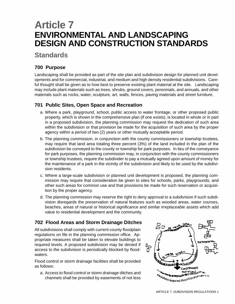
ARTICLE 7, SUBDIVISION REGULATIONS 1
Article 7ENVIRONMENTAL AND LANDSCAPINGDESIGN AND CONSTRUCTION STANDARDSStandards
700 PurposeLandscaping shall be provided as part of the site plan and subdivision design for planned unit devel-opments and for commercial, industrial, and medium and high density residential subdivisions. Care-ful thought shall be given as to how best to preserve existing plant material at the site. Landscapingmay include plant materials such as trees, shrubs, ground covers, perennials, and annuals, and othermaterials such as rocks, water, sculpture, art, walls, fences, paving materials and street furniture.
701 Public Sites, Open Space and Recreationa. Where a park, playground, school, public access to water frontage, or other proposed public
property, which is shown in the comprehensive plan (if one exists), is located in whole or in partin a proposed subdivision, the planning commission may request the dedication of such areawithin the subdivision or that provision be made for the acquisition of such area by the properagency within a period of two (2) years or other mutually acceptable period.
b. The planning commission, in conjunction with the county commissioners or township trustees,may require that land area totaling three percent (3%) of the land included in the plan of thesubdivision be conveyed to the county or township for park purposes. In lieu of the conveyancefor park purposes, the planning commission may, in conjunction with the county commissionersor township trustees, require the subdivider to pay a mutually agreed upon amount of money forthe maintenance of a park in the vicinity of the subdivision and likely to be used by the subdivi-sion residents.
c. Where a large-scale subdivision or planned unit development is proposed, the planning com-mission may require that consideration be given to sites for schools, parks, playgrounds, andother such areas for common use and that provisions be made for such reservation or acquisi-tion by the proper agency.
d. The planning commission may reserve the right to deny approval to a subdivision if such subdi-vision disregards the preservation of natural features such as wooded areas, water courses,beaches, areas of natural or historical significance and similar irreplaceable assets which addvalue to residential development and the community.
702 Flood Areas and Storm Drainage DitchesAll subdivisions shall comply with current county floodplainregulations on file in the planning commission office. Ap-propriate measures shall be taken to elevate buildings torequired levels. A proposed subdivision may be denied ifaccess to the subdivision is periodically blocked by flood-waters.
Flood control or storm drainage facilities shall be providedas follows:
a. Access to flood control or storm drainage ditches andchannels shall be provided by easements of not less

ARTICLE 7, SUBDIVISION REGULATIONS 2
than twenty (20) feet in width, located on one side of the flood control or drainage ditch, channelor similar facilities.
b. Flood control or storm drainage easements containing underground facilities shall have a mini-mum width of twenty (20) feet.
c. Whenever a flood control or storm drainage ditch or channel has a depth of five (5) feet or more,or a bank slope of two (2) feet horizontal to one (1) vertical or steeper, a five (5) foot highmasonry wall or a five (5) foot high chain link fence may be required by the planning commis-sion.
703 Soil Erosion Requirementsa. In the development of a subdivision, the developer shall not cause or allow earth-disturbing
activities that can pollute a public or private surface ditch, subsurface drainage, stream, river orlake. The developer shall also, to the greatest extent possible, take steps so that sediment willnot be deposited onto an adjoining property. Adequate control of soil erosion and sedimentation,through the use of best management practices with both temporary and permanent measures,shall be used during all phases of clearing, grading, and construction to conserve soil resourcesand to maintain existing water quality. Sediment control shall follow the standards and specifica-tions in Rainwater and Land Development: Ohio’s Standards for Stormwater Management, LandDevelopment and Urban Stream Protection, Second Edition, 1996 (Department of Natural Re-sources, Division of Soil and Water Conservation).
b. When a proposed development area consists of five (5) or more acres of earth-disturbing activi-ties, the owner of record shall develop and submit to the Soil & Water Conservation District forreview and approval, a soil erosion and sedimentation control plan. Such a plan shall containsufficient information, drawings and notes to describe how soil erosion and off-site sedimenta-tion will be kept to a minimum, both during and after construction. A copy of such plan shall befiled with the planning commission.
c. When a proposed development area involves less than five acres, it is not necessary to submita soil erosion and sedimentation control plan; however, the developer shall comply with thestandards and specifications in Rainwater and Land Development: Ohio’s Standards forStormwater Management, Land Development and Urban Stream Protection, Second Edition,1996 (Department of Natural Resources, Division of Soil and Water Conservation). Upon re-quest, submittal of specific soil erosion and sedimentation prevention measures to be or beingimplemented may be required to determine compliance.
d. Soil erosion and sedimentation control plans shall be certified by a professional engineer regis-tered in the State of Ohio before being submitted to the Soil and Water Conservation District andthe planning commission for review and approval.
704 Landscape PlanA landscape plan shall be submitted with each site plan application for planned developments, com-mercial, industrial, and/or high density residential subdivisions, unless an exception is granted by theplanning commission pursuant to these Regulations. The landscape plan shall identify existing andproposed trees, shrubs, and ground covers; natural features such as rock outcroppings; and otherlandscaping elements. Where existing plants are to be retained, the applicant shall include in theplans proposed methods of protecting them during construction.
705 Site Protection and General Planting Requirementsa. Topsoil Preservation: Topsoil shall be temporarily stored and later redistributed on all re-
graded surfaces so as to provide at least (4) inches of even cover to all disturbed areas of thedevelopment and shall be stabilized by seeding or planting.

ARTICLE 7, SUBDIVISION REGULATIONS 3
b. Removal of Debris: All stumps and other tree parts, litter, brush, weeds, excess or scrapbuilding materials or other debris shall be removed from the site and disposed of in accordancewith the law. No tree stumps, or portions of tree trunks or limbs shall be buried anywhere in thedevelopment. If trees and limbs are reduced to chips, they may be used as mulch in landscapedareas, subject to approval by the planning commission.
c. Protection of Existing Plantings: Maximum effort should be made to save fine or exceptionalplant specimens. No material or temporary soil deposits shall be placed within four (4) feet ofshrubs or ten (10) feet of trees designated on the landscape plan to be retained. Protectivebarriers or tree wells shall be installed around each plant and/or group of plants that are toremain on the site. Barriers shall not be supportedby the plants they are protecting, but shall be self-supporting. They shall be a minimum of four (4) feethigh and constructed of a durable material that willlast until construction is completed. Snow fences andsilt fences are examples of acceptable barriers.
d. Slope Plantings: Landscaping of all cuts and fillsand/or terraces shall be sufficient to prevent erosion,and all roadway slopes steeper than one (1) foot ver-tically to three (3) feet horizontally shall be plantedwith ground cover appropriate for the purpose andfor soil conditions, water availability, and environment.
e. Additional Landscaping: In residential develop-ments, besides the screening and street trees re-quired, additional plantings or landscaping elementsmay be required throughout the subdivision wherenecessary for climate control, privacy, or other rea-sons in accordance with the landscape plan approvedby the planning commission taking cost constraintsinto consideration. In non-residential developments,all areas of the site not occupied by buildings andrequired improvements shall be landscaped by theplanting of grass or other ground cover, shrubs, andtrees as part of the landscape plan approved by theplanning commission.
f. Planting Specifications: Deciduous trees shall have at least a two-inch caliper at planting.Size of evergreens and shrubs shall be allowed to vary depending on setting and type of shrub.All trees, shrubs, and ground covers shall be planted according to accepted horticultural stan-dards. Dead and dying plants shall be replaced by the developer during the following plantingseason.
g. Plant Species: The plant species selected shall be hardy for the climate and appropriate interms of function and size.
706 Shade TreesShade trees shall be installed on both sides of allstreets in accordance with the approved landscapeplan. When trees are planted at predetermined in-tervals along streets, spacing shall depend on treesize (at maturity), as shown in Table 14.
When the spacing interval exceeds 40 feet, smallornamental trees can be placed between the larger
Large trees (40+) 50-70
Medium trees (30-40) 40-50
Small trees (to 30) 30-40
Table 14: Spacing Between Shade Trees
Tree Height(feet)
Planting Interval(feet)

ARTICLE 7, SUBDIVISION REGULATIONS 4
trees. If a street canopy effect is desired, trees may be planted closertogether, following the recommendations of a registered landscape ar-chitect. The planting of trees shall be coordinated with utilities, road-ways, sidewalks, sight easements, or streetlights. Tree location, land-scaping design, and tree spacing shall be approved by the planningcommission as part of the landscape plan.
707 BufferingBuffering is the provision of an area between different land uses thatattempts to minimize negative environmental impacts from one to theother. Buffers shall provide a year-round visual screen in order to mini-mize adverse impacts. They may consist of fencing, evergreens, berms,rocks, boulders, mounds, or combinations thereof to achieve the sameobjectives. Every developer shall provide sufficient buffering when topographical or other barriers do
not provide reasonable screening and when the plan-ning commission determines that there is a need toshield (1) neighboring properties from any adverse ex-ternal effects of a development; or (2) the developmentfrom negative impacts of adjacent uses such as streetsor railroads. In high-density developments, when build-ing design and siting do not provide privacy, the plan-ning commission may require landscaping, fences, orwalls to screen dwelling units for privacy. Buffers shallbe measured from side and rear property lines, exclud-ing driveways. Plant materials shall be sufficiently largeand planted in such a fashion that a year-round screenat least eight (8) feet in height shall be produced withinthree (3) growing seasons. All plantings shall be installedaccording to accepted horticultural standards.
708 MaintenancePlantings shall be watered regularly and in a manner appropriate for the specific plant species throughthe first growing season, and dead and dying plants shall be replaced by the applicant during the nextplanting season. No buildings, structures, storage of materials, or parking shall be permitted withinany buffer area. Buffer areas shall be maintained and kept free of all debris, rubbish, weeds, and tallgrass.
709 Parking Lot Landscapinga. In parking lots, at least five percent (5%) of the interior parking area shall be landscaped with
plantings, and one (1) tree for each eight (8) spaces shall be installed. Parking lot street frontagescreening and perimeter screening shall be a minimum of five (5) feet wide. Planting requiredwithin the parking lot is exclusive of other planting requirements, such as shade trees plantedalong the street.
Parking lots, garbage collection, utility areas, 5 feet width minimumand loading and unloading areas
All other land uses 25 feet width minimum
Table 15: Buffer Strip Width

ARTICLE 7, SUBDIVISION REGULATIONS 5
b. Landscaping should be located in protected areas, such as along walkways, in center islands, atthe ends of bays, or between parking stalls. All landscaping in parking areas and on the streetfrontage shall be placed so that it will not obstruct sight distance. Plantings in parking areas andon streets shall pay particular attention to sun position during the summer months so that maxi-mum cooling effects can be gained from well-placed trees.
c. A mixture of hardy flowering and/or decorative evergreen and deciduous trees may be planted.The evergreens should be used along the perimeter of the lot for screening, and the deciduoustrees for shade within the lot. The area between trees shall be mulched or planted with shrubs orground cover. Any area that will be under the overhang of vehicles shall be mulched or coveredwith paving material.
710 Paving MaterialsDesign and choice of paving materials used in pedestrian areas shall consider such factors as func-tion, climate, characteristics of users, availability, cost, maintenance, glare, drainage, noise, appear-ance, and compatibility with surroundings.
Acceptable materials shall include, but are not limited to, concrete, brick, cement pavers, asphalt, andstone.
711 Walls and FencesWalls and fences shall be erected where required for privacy, screening, separation, security, erosioncontrol, or to serve other necessary and reasonable functions. The design and materials used shall befunctional and compatible with existing and proposed site architecture. No fence or wall shall be soconstructed or installed as to constitute a hazard to traffic or safety.
712 Street FurnitureStreet furniture such as trash receptacles, benches, and phone booths, shall be located and sized inaccordance with their function. The different street furniture components shall be compatible in form,material, and finish. Design and materials shall be coordinated with existing and proposed site archi-tecture. Selection of street furniture shall take into consideration functionality and durability.

ARTICLE 7, SUBDIVISION REGULATIONS 6
Commentary on Article 7
701 Public Sites, Open Space, and RecreationThe planning commission may require the developer of cluster subdivisions and planned unit developments toprovide outdoor recreational space based on the concept of concentrating development in physically suitablelocations, in order to protect open or environmentally sensitive areas. The planning commission may requiredevelopers to contribute in-lieu fees to a recreational fund so that the appropriate oversight agency will have theresources to provide recreational facilities on a wider basis for multiple developments.
The planning commission may permit minor deviations from the standards contained in these Regulations whenit can be determined that the objectives can be met without strict adherence to them, or because of the peculiari-ties of the land or proposed facilities. The type of ownership of land dedicated for open space may be selected bythe subdivider, subject to the approval of the planning commission. The open space manager may includecounties, townships, park districts, quasi-public organizations, homeowners associations, or condominium as-sociations.
702 Flood Areas and Storm Drainage DitchesAccess to subdivisions should be elevated above the 100 year flood level. It is important to study the floodplainmaps covering the area adjacent to the proposed subdivision.
703 Soil Erosion RequirementsProfessional engineers utilized for subdivision design should be familiar with standards and specifications inRainwater and Land Development: Ohio’s Standards for Stormwater Management, Land Development andUrban Stream Protection, Second Edition, 1996 (Department of Natural Resources, Division of Soil and WaterConservation) and should design construction projects to meet these standards.
704 Landscape PlanFor small subdivisions the landscape plan may be limited, consisting only of the number and type of foundationplanting and street trees. For large developments requirements are more extensive including planting details,buffering, and the landscaping of public areas and parking lots.
The Ohio Department of Natural Resources, Division of Forestry, employs urban foresters who can be of assis-tance with landscape designs.
705 Site Protection and General Planting RequirementsCounty soil and water conservation districts can assist with designing landscape plans to minimize erosion andstormwater problems.
706 Shade TreesMany urban areas have shade tree commissions and urban forestry professionals that can offer assistance.

ARTICLE 8, SUBDIVISION REGULATIONS 1
Article 8REQUIREMENTS FOR CONSTRUCTION OFIMPROVEMENTSStandards
800 Improvement and Cost Estimate InformationBefore the signing of the final plat, all applicants shall be required to complete, to the satisfaction ofthe county engineer, county health department or other appropriate agency, all the streets, sanitaryimprovements, and other public improvements, including lot improvements on the individual lots, aslisted on the preliminary plan and engineering plans and as construction-certified on the final plat.When required improvements are not completed, the subdivider shall insure their completion with aperformance guarantee acceptable to the planning commission and board of county commissioners.
All required improvements shall be made by the developer, at his or her expense, and cost estimatesfor various materials and labor shall be provided as requested by a professional engineer licensed inthe State of Ohio. The developer shall dedicate public improvements to the local government, freeand clear of all liens and encumbrances on the dedicated property and public improvements.
801 Performance Guarantee for Installation and Maintenance ofImprovementsTo guarantee the construction and/or maintenance of required improvements prior to the approvaland recording of the final plat, the subdivider shall be required to provide a performance guarantee inone or a combination of the following arrangements:
a. Performance Bond, Certified Check, or Irrevocable Letter of Credit: The subdivider shallpost a bond, executed by a surety company, or a certified check or irrevocable letter of creditequal to the estimated cost plus ten (10) percent of the required improvements. The bond shallbe in favor of the board of county commissioners, and shall guarantee construction of the im-provements according to the plans and specifications approved by the planning commission.The term of the bond shall not exceed two (2) years plus a one (1) year maintenance period fora total of three (3) years.The planning commission may grant an extension where due causecan be shown. The bond amount can be reduced to a percentage of its original amount duringthe one year maintenance period. Under no circumstances shall the required performance bond,cash deposit or irrevocable letter of credit be tied to or be considered a portion of the developer’sfinancing for the development.
b. Deposit: The subdivider may make a deposit with the county treasurer, with a responsible es-crow agent, or with a trust company. The deposit shall be money or negotiable bonds in anamount equal to the estimated cost plus ten (10) percent of the required improvements. If acash deposit is made, an agreement may be executed to provide payments to the contractor orthe subdivider from the deposit as the work progresses and is approved by the responsiblecounty officials.
c. Contract Documents or Escrow Agreements: Where contract documents or escrow agree-ments for the proposed improvements are available, copies of such contracts shall be certifiedto the board of county commissioners and, when approved, will constitute sufficient guaranteefor the installation of required improvements in lieu of other methods stated above.

ARTICLE 8, SUBDIVISION REGULATIONS 2
802 Temporary ImprovementsThe applicant shall build and pay for all temporary improvements required by the planning commis-sion and shall maintain those temporary improvements for the period specified by the planning com-mission. Prior to construction of any temporary facility or improvement, the developer shall file withthe planning commission a separate performance guarantee in an amount equal to the estimated costof the temporary facilities, which shall ensure that the temporary facilities will be properly constructed,maintained and removed.
803 Extension of TimeIf the construction or installation of any improvements or facility, for which guarantee has been madeby the developer in the form of a performance bond, cash deposit, or irrevocable letter of credit, is notcompleted within two (2) years from the date of final approval of the recorded plat, the developer mayrequest the board of county commissioners to grant an extension of six (6) months, provided he canshow reasonable cause for inability to complete said improvements within the required two (2) years.The request shall be accompanied by revised cost estimate of construction to be completed.
804 Failure to Complete ImprovementsIn case the subdivider fails to complete the required public improvements work within such time pe-riod as required by the conditions or guarantees as outlined above, the board of county commission-ers may proceed to have such work completed and reimburse itself for the cost thereof by appropriat-ing the cash deposit, certified check, surety bond, or by drawing upon the letter of credit, or shall takethe necessary steps to require performance by the bonding company.
805 Progressive InstallationAfter the preliminary plan of a proposed subdivision has been approved by the planning commission,the subdivider may improve a part of the entire area and submit a final plat for that improved portionto the planning commission for approval.
806 Deferral or Waiver of Required ImprovementsThe planning commission may defer or waive, at the time of final plat approval and subject to appro-priate conditions, the provision of any or all public improvements as, in its judgment, are not requisitein the interest of the public health, safety, or welfare, or which are inappropriate because of the inad-equate or nonexistence of connecting facilities. Any determination to defer or waive the provision ofcertain public improvements must be expressly made on the record.
Whenever it is deemed necessary by the planning commission to defer the construction of any im-provement, the subdivider shall pay his share of the costs of the future improvements to the countyprior to the signing of the final subdivision plat by the planning commission. The developer may pro-vide a separate performance bond, cash deposit or irrevocable letter of credit for the completion of thedeferred improvements upon demand of the county.
807 Inspection of ImprovementsThe planning commission shall coordinate with the county engineer, county health department, orother appropriate agency to provide for inspection of required improvements during construction andensure their satisfactory completion. The applicant shall pay to the planning commission an inspec-tion fee, and shall notify proper administrative officials at least twenty-four (24) hours before eachphase of the improvements is ready for inspection. The planning commission may waive the require-ment for inspection fees to be paid by the developer. Work requiring periodic inspections and aninspection schedule shall be finalized by the developer and inspectors before any work begins. If, inthe opinion of the inspector, installations are improper or inadequate, the inspector shall issue a stop

ARTICLE 8, SUBDIVISION REGULATIONS 3
order. The developer may appeal the inspector’s findings to the county engineer and/or sanitary engi-neer within forty-eight (48) hours. Failure to comply with the inspector, county and/or sanitary engineer’sdirective, will be deemed a violation of these Regulations subject to having the approved final platinvalidated by the board of county commissioners.
808 Completion of Work and Reduction of SecurityAs required improvements are completed, the board of county commissioners may, with concurrenceof the county engineer and planning commission, reduce the amount of the performance bond, cashdeposit, or irrevocable letter of credit, in the following increments: 25%, 50%, and 75%. Twenty twopercent (22%) of the remaining amount of the guarantee shall be released when all construction,installation, and improvements by the subdivider’s contract have been completed and approved bythe respective government authorities. The remaining three percent (3%) will be held for a one yearmaintenance period. Performance bonds, cash deposit, or irrevocable letter of credit for roads, stormdrainage, water and sanitary sewer improvements shall not be released independently.
809 Acceptance of Streets, Storm Drainage, Sanitary Sewer and WaterDistribution Improvements for Use and Maintenance by the Public
The subdivider shall have properly constructed and maintained all required improvements at the timehe requests their acceptance by the board of county commissioners. Upon completion of all improve-ments, the developer shall request that the county engineer perform an inspection for conditionalacceptance. After the inspection, the county engineer will do one of the following:
a. Issue a letter to the board of county commissioners, with a copy to the developer, recommend-ing conditional acceptance and the amount of a maintenance bond.
b. Issue a letter to the developer, with a copy to the board of county commissioners listing items ofwork necessary to accomplish satisfactory completion of the improvements.
Upon completion of the improvements and conditional acceptance by the board of county commis-sioners, the developer shall furnish a maintenance guarantee in the amount of 3% of the total perfor-mance guarantee or $1000.00, whichever amount is the larger. The subdivider shall be responsiblefor routine maintenance of all improvements and shall repair all failures due to faulty construction assoon as they become apparent. Said subdivider shall also make repairs due to erosion or abuse byutility companies installing utilities and shall repair all failure, for all other reasons, during the one (1)year period. He shall restore the improvements at the end of the maintenance period.
The improvements will be eligible for final acceptance one year after the conditional acceptance. Themaintenance bond shall remain in effect until final acceptance by the board of county commissioners.Before the board of county commissioners will release the maintenance bond or maintenance fund,the developer shall submit a sworn statement that all bills and financial obligations incurred for main-tenance or restoration of the subdivision improvements have been fully paid.
One year after conditional acceptance, the developer shall, after restoring all improvements to anacceptable condition, and after all monies are paid, request that the county engineer perform aninspection for final acceptance. After the inspection, the county engineer will do one of the following:
a. Issue a letter to the board of county commissioners, with a copy to the developer, recommend-ing final acceptance of the improvements and release of maintenance bond(s).
b. Issue a letter to the developer, with a copy to the board of county commissioners, listing items ofwork necessary to accomplish before the recommendation for final acceptance can be made.

ARTICLE 8, SUBDIVISION REGULATIONS 4
Commentary on Article 8
800 Improvements and Cost Estimate InformationThe planning commission requirement to complete improvements before plat approval often causes long de-lays. Consequently, subdivision plat approval may be granted prior to completion of improvements if the sub-divider guarantees construction by posting some type of security. The nature and amount of improvementguarantees should reflect a balancing of interests, and developers should not be required to provide guaranteeswhich are excessive in amount, duration, and cost. The amount of the improvement guarantee is based upon theprofessional engineer’s estimated cost of improvements.
801 Performance Guarantee for Installation and Maintenance of ImprovementsThe performance guarantee shall be for an amount not to exceed one hundred ten (110) percent of the cost ofinstalling the improvements. The added ten (10) percent is included to provide for a margin of error and to coverinflation and institutional cost in case the planning commission is forced to provide improvements in the future.The term of two (2) years required to maintain the guarantee is reasonable for determining if an improvement isfunctioning properly.
The maintenance period is for one year from the date of acceptance of dedication and provides a guarantee forthe local government should any repairs be necessary during the first twelve months after acceptance of dedica-tion.
805 Progressive InstallationWith large projects improvements are usually made on an incremental basis. The planning commission mayallow progressive installation of improvements and partial release of the guarantee reflecting the phase of im-provements which have been made.
807 Inspection of ImprovementsPeriodic inspections shall be made to ensure conformity with the approval plans and specifications required bythese and other regulations. The subdivider shall notify proper administrative officials at least twenty four (24)hours before each phase of the improvements is ready for inspection. Normally inspections shall be providedbefore road surfacing, road base construction, road subbase construction, utility excavation and placement,reinforcing steel placement before concrete pours, storm sewer and culvert installation, and other operationsspecified by the county engineer and sanitary engineer.
809 Acceptance of Streets, Storm Drainage, Sanitary Sewer and Water DistributionImprovements for Use and Maintenance by the Public
Neither the approval of the final plat or the partial release of security constitutes an acceptance of dedication ofpublic improvements. Acceptance of dedication by the county commissioners occurs after final inspection andapproval, resulting in the transfer of title from the developer to the county or township. After the date ofacceptance of dedication, the burden of maintaining and repairing the improvements falls upon the county ortownship.
ARTICLE 9, SUBDIVISION REGULATIONS 1
Article 9PLANNED UNIT DEVELOPMENTStandards
900 General StatementThe planned unit development is a contiguous area to be planned and developed as a single entitycontaining one or more structures to accommodate residential, commercial and/or industrial uses inaccordance with applicable zoning resolutions. Zoning approval of a planned unit development doesnot constitute subdivision approval. The procedure for approval of planned unit developments aresubject to the approval procedure specified by Article 3 of these Regulations.
901 Purpose of Planned Unit DevelopmentPlanned unit development of land may be permitted in order to provide a means for a more desirablephysical development pattern than would be possible through the strict application of zoning regula-tions and subdivision regulations. The planning commission will permit certain variety and flexibility inland development to encourage the subdivider to adjust design to irregular topography, economize inthe construction of utilities, and create architectural variation as well as attractive and usable buildingsand building sites.
902 Uses PermittedCompatible residential, commercial, industrial, public and quasi-public uses may be combined, pro-vided that the proposed location of the commercial or industrial uses will not adversely affect or disre-gard adjacent property, public health, safety, and the general welfare. A variety of housing and build-ing types is encouraged by permitting a higher per acre housing density and a reduction in lot dimen-sions and yard and building setbacks, compared with conventional development standards.
903 General Requirementsa. The gross area of the tract to be developed under the planned unit development approach shall
comprise not less than (10) acres, unless otherwise approved by the planning commission.
b. The total ground area occupied by buildings and structures shall not exceed (80) percent of thetotal ground area, unless previous development in the neighborhood has a greater ground cov-erage, in which case the plan may increase the ground coverage of buildings and structures tocorrespond with the average coverage in the neighborhood.
c. A minimum of (10) percent of the land developed shall be reserved for open space and similaruses such as an internal park network, recreational facilities, and preservation of natural fea-tures.
d. The minimum lot size shall be not less than (70) percent of the lot area per family or use whichwould be otherwise be required under these Regulations. Lot widths and required yards may bereduced to (80) percent of the requirements of these Regulations.
e. The design of the internal circulation system shall provide convenient access to dwelling unitsand non-residential facilities, separation of vehicular and pedestrian traffic, shall be adequate tocarry anticipated traffic, including access for emergency vehicles.
904 Open SpaceThe amount of open space reserved in the planned unit development shall either be held in corporateownership by the owners of the project area, for the use of those who buy property, be held by an

ARTICLE 9, SUBDIVISION REGULATIONS 2
association of property owners within the development, or be dedicated to the county or township andretained as open space or related uses.
All land dedicated to county or township shall meet the requirements of the planning commission.Public utility or water course easements are not acceptable for open space dedication unless suchland is usable as a trail and approved by the planning commission.
905 Management of Common PropertyA homeowner’s association, or in the case of non-residential development, an owners association,shall be established to provide for the maintenance of all facilities and/or properties held in commonwithin planned unit developments. These shall include, but not be limited to, private streets and walk-ways, private recreational facilities, common lots and open space areas.
The developer shall submit evidence as to the financial ability of the homeowners association tomaintain any property or facilities held in common ownership, including the estimated annual cost ofmaintaining all common properties and facilities; the estimated monthly fee which shall be assessedto each residential property; and an estimate of the value of the dwelling units which will be con-structed within the planned unit development. Any homeowners association and accompanying regu-lations shall be reviewed and approved by the county prosecutor.
906 Open Space Improvement GuaranteeAt the time of the application for final plat approval, the subdivider shall provide:
a. A performance guarantee in accordance with Section 801 of these Regulations, in the amountof the estimated cost of the proposed improvements.
b. A maintenance guarantee, in accordance with Section 801 of these Regulations, in such amountas determined and approved by the planning commission that shall be arranged for a period of(1) year from the date of acceptance of the improvements.
907 Conformity to Existing Streets and Thoroughfare PlanWhenever a planned unit development abuts or contains an existing or proposed major thoroughfareor minor existing street, the roadway standards as contained in these Regulations shall be applicable.
908 Public StreetsThe planning commission may require certain streets within the planned unit development be public ifit determines that the project density necessitates the use of public streets for adequate circulation.
909 Private StreetsPrivate streets may be permitted in planned unit developments and shall meet the construction re-quirements of these Regulations. Private streets shall be owned and maintained by abutting propertyowners and other persons to whom the streets provide access
910 Staging of Residential Planned Unit Developmenta. Each stage of a planned unit development must be so designed so as to stand independently of
future related stages, in the event future stages are not constructed. The construction andprovision of all the common open spaces and public and recreational facilities which are shownon the final development plan must proceed at the same rate as the construction of dwellingunits.
b. If a planned unit development contains non-residential uses, these uses may be constructedfirst, but only if the planning commission approves such construction on the final developmentplan.

ARTICLE 9, SUBDIVISION REGULATIONS 3
Commentary on Article 9
900 General StatementPlanned unit development (PUD) is an alternative to the conventional lot-by-lot development in which zoningregulates the location of buildings and subdivision regulations controls the development of blocks and lots.Regarding PUD, the planning commission reviews and approves the plan as a whole, without the restrictionsimposed by standard subdivision regulations. In this type of development, bulk requirements, parking, andother development standards are flexible in order to achieve better site design.
902 Uses PermittedUses permitted usually include: single family residential, apartment houses, two-family dwellings, duplexes,double duplexes, and four family rows; accessory buildings for residential use and religious activities; parks,playgrounds, athletic areas, golf courses, swimming pools, lakes and undeveloped areas for passive recreation,child day care; primary and secondary education; and horticulture.
904 Open SpaceMaintenance of open space is one of the major problems with a PUD especially when the county or township isnot willing to accept the expense of maintaining such areas. A solution to this problem is to form a homeownersassociation (HOA), an organization composed of the lot owners in the subdivision. The rules of the association,which by deed restrictions apply to each lot, allow for levying an annual payment from each owner to pay formaintenance.
Technical assistance about managing HOA’s is available from a national nonprofit group, the Community Asso-ciations Institute, 1630 Duke Street, Alexandria, VA, 22314.
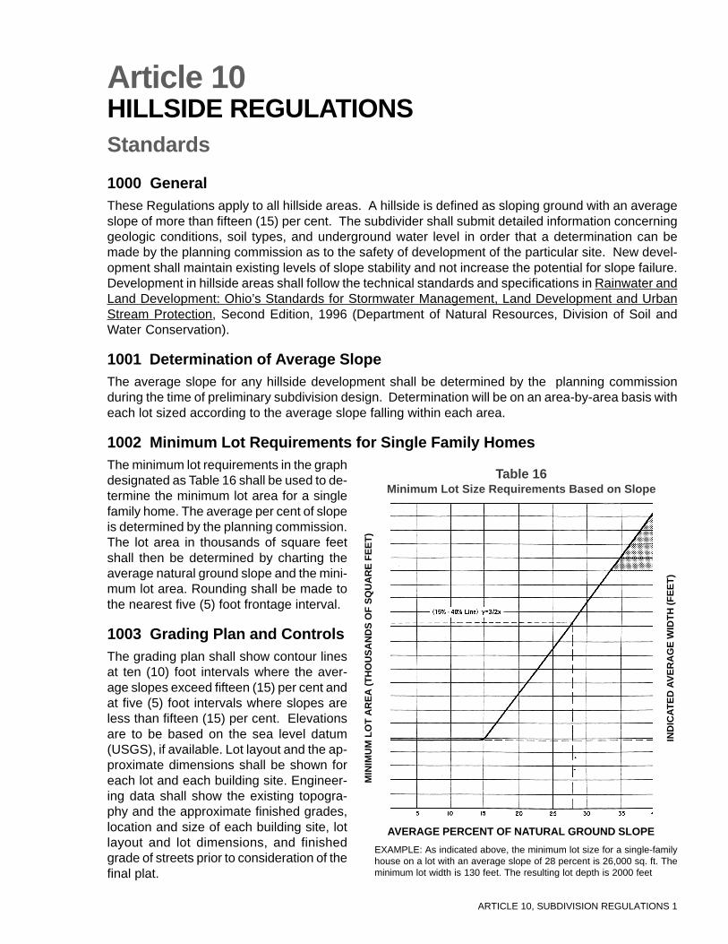
ARTICLE 10, SUBDIVISION REGULATIONS 1
Article 10HILLSIDE REGULATIONSStandards
1000 GeneralThese Regulations apply to all hillside areas. A hillside is defined as sloping ground with an averageslope of more than fifteen (15) per cent. The subdivider shall submit detailed information concerninggeologic conditions, soil types, and underground water level in order that a determination can bemade by the planning commission as to the safety of development of the particular site. New devel-opment shall maintain existing levels of slope stability and not increase the potential for slope failure.Development in hillside areas shall follow the technical standards and specifications in Rainwater andLand Development: Ohio’s Standards for Stormwater Management, Land Development and UrbanStream Protection, Second Edition, 1996 (Department of Natural Resources, Division of Soil andWater Conservation).
1001 Determination of Average SlopeThe average slope for any hillside development shall be determined by the planning commissionduring the time of preliminary subdivision design. Determination will be on an area-by-area basis witheach lot sized according to the average slope falling within each area.
1002 Minimum Lot Requirements for Single Family HomesThe minimum lot requirements in the graphdesignated as Table 16 shall be used to de-termine the minimum lot area for a singlefamily home. The average per cent of slopeis determined by the planning commission.The lot area in thousands of square feetshall then be determined by charting theaverage natural ground slope and the mini-mum lot area. Rounding shall be made tothe nearest five (5) foot frontage interval.
1003 Grading Plan and ControlsThe grading plan shall show contour linesat ten (10) foot intervals where the aver-age slopes exceed fifteen (15) per cent andat five (5) foot intervals where slopes areless than fifteen (15) per cent. Elevationsare to be based on the sea level datum(USGS), if available. Lot layout and the ap-proximate dimensions shall be shown foreach lot and each building site. Engineer-ing data shall show the existing topogra-phy and the approximate finished grades,location and size of each building site, lotlayout and lot dimensions, and finishedgrade of streets prior to consideration of thefinal plat.
EXAMPLE: As indicated above, the minimum lot size for a single-familyhouse on a lot with an average slope of 28 percent is 26,000 sq. ft. Theminimum lot width is 130 feet. The resulting lot depth is 2000 feet
AVERAGE PERCENT OF NATURAL GROUND SLOPE
MIN
IMU
M L
OT
AR
EA
(T
HO
US
AN
DS
OF
SQ
UA
RE
FE
ET
)
IND
ICA
TE
D A
VE
RA
GE
WID
TH
(FE
ET
)
Table 16Minimum Lot Size Requirements Based on Slope
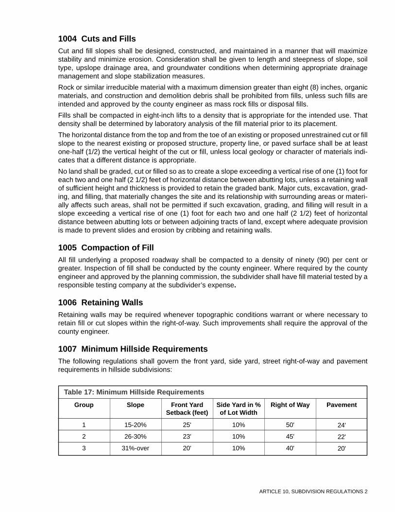
ARTICLE 10, SUBDIVISION REGULATIONS 2
1004 Cuts and FillsCut and fill slopes shall be designed, constructed, and maintained in a manner that will maximizestability and minimize erosion. Consideration shall be given to length and steepness of slope, soiltype, upslope drainage area, and groundwater conditions when determining appropriate drainagemanagement and slope stabilization measures.
Rock or similar irreducible material with a maximum dimension greater than eight (8) inches, organicmaterials, and construction and demolition debris shall be prohibited from fills, unless such fills areintended and approved by the county engineer as mass rock fills or disposal fills.
Fills shall be compacted in eight-inch lifts to a density that is appropriate for the intended use. Thatdensity shall be determined by laboratory analysis of the fill material prior to its placement.
The horizontal distance from the top and from the toe of an existing or proposed unrestrained cut or fillslope to the nearest existing or proposed structure, property line, or paved surface shall be at leastone-half (1/2) the vertical height of the cut or fill, unless local geology or character of materials indi-cates that a different distance is appropriate.
No land shall be graded, cut or filled so as to create a slope exceeding a vertical rise of one (1) foot foreach two and one half (2 1/2) feet of horizontal distance between abutting lots, unless a retaining wallof sufficient height and thickness is provided to retain the graded bank. Major cuts, excavation, grad-ing, and filling, that materially changes the site and its relationship with surrounding areas or materi-ally affects such areas, shall not be permitted if such excavation, grading, and filling will result in aslope exceeding a vertical rise of one (1) foot for each two and one half (2 1/2) feet of horizontaldistance between abutting lots or between adjoining tracts of land, except where adequate provisionis made to prevent slides and erosion by cribbing and retaining walls.
1005 Compaction of FillAll fill underlying a proposed roadway shall be compacted to a density of ninety (90) per cent orgreater. Inspection of fill shall be conducted by the county engineer. Where required by the countyengineer and approved by the planning commission, the subdivider shall have fill material tested by aresponsible testing company at the subdivider’s expense.
1006 Retaining WallsRetaining walls may be required whenever topographic conditions warrant or where necessary toretain fill or cut slopes within the right-of-way. Such improvements shall require the approval of thecounty engineer.
1007 Minimum Hillside RequirementsThe following regulations shall govern the front yard, side yard, street right-of-way and pavementrequirements in hillside subdivisions:
1
2
3
Table 17: Minimum Hillside Requirements
Group Slope Front YardSetback (feet)
Side Yard in %of Lot Width
Right of Way
15-20%
26-30%
31%-over
25'
23'
20'
10%
10%
10%
24'
22'
20'
Pavement
50'
45'
40'

ARTICLE 10, SUBDIVISION REGULATIONS 3
1008 Street AlignmentThe following regulations shall govern street alignment:
a. Vertical profile grades shall be connected by vertical curves up to fifteen (15) percent, but onlyfor short, straight stretches.
b. Waiver of visibility requirements may be given subject to the approval of the planning commis-sion upon recommendation of the county engineer.
c. Waiver of vertical curve requirements may be given subject to the approval of the planningcommission upon recommendation of the county engineer.
1009 DrivewaysThe maximum grade on that portion of a driveway within a public right-of-way shall not exceed fifteen(15) percent. Each drive shall provide sufficient space and distance to turn around prior to entering thestreet. When the average slope on a lot will exceed fifteen (15) percent, the driveway location shall beshown on the preliminary plan (or final plat if no preliminary plan was submitted). Driveways shall bedesigned and constructed so as to drain into the roadway ditch and not onto the roadway surface.The area of the driveway adjacent to the roadway shall drain away from the roadway.
ARTICLE 10, SUBDIVISION REGULATIONS 4
Commentary on Article 10
1000 GeneralDevelopment in hillside areas requires extra planning to guarantee the health, safety, and welfare of futuresubdivision residents. Design professionals should have experience working with steep topography and with thesoil types at the site. Natural Resource Conservation Service and local soil and water district personnel shouldbe consulted for hillside developments. Percent slope is determined by calculating vertical rise in feet for every100 feet horizontal. Soil maps are available at the offices of the county soil and water conservation district.
1001 Determination of Average SlopeAssistance can be provided by the District Conservationist with the Natural Resources Conservation Service.
1002 Minimum Lot Requirements for Single Family HomesLand that is more steeply sloped requires bigger lots and greater average lot width. This allows for greaterflexibility for driveway access design, septic system or aeration system placement, and construction-relatedearthwork.
1004 Cuts and FillsThe stability of hillside areas shall be as stable, post-construction, as they were before development began. Ifengineering plans cannot demonstrate that adequate measures have been taken to guarantee this level of stabil-ity, the subdivision should not be approved.
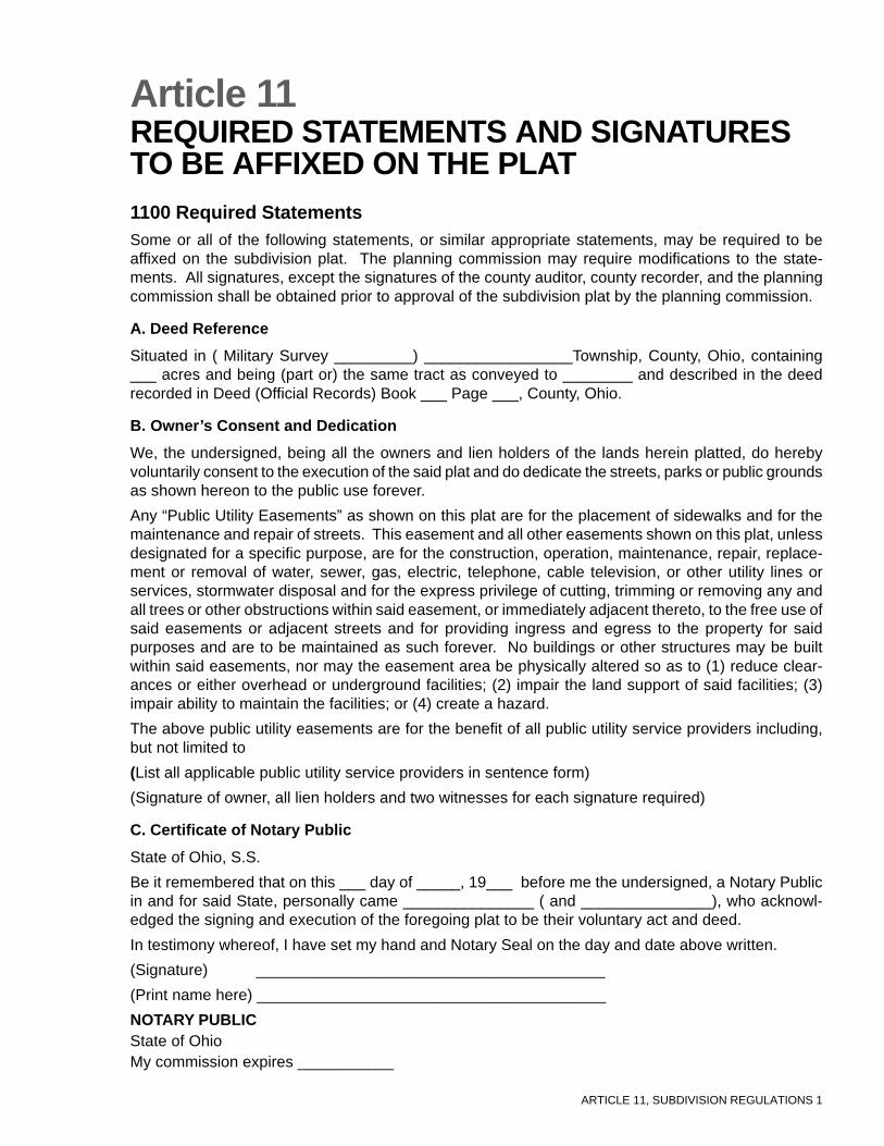
ARTICLE 11, SUBDIVISION REGULATIONS 1
Article 11REQUIRED STATEMENTS AND SIGNATURESTO BE AFFIXED ON THE PLAT1100 Required StatementsSome or all of the following statements, or similar appropriate statements, may be required to beaffixed on the subdivision plat. The planning commission may require modifications to the state-ments. All signatures, except the signatures of the county auditor, county recorder, and the planningcommission shall be obtained prior to approval of the subdivision plat by the planning commission.
A. Deed Reference
Situated in ( Military Survey _________) _________________Township, County, Ohio, containing___ acres and being (part or) the same tract as conveyed to ________ and described in the deedrecorded in Deed (Official Records) Book ___ Page ___, County, Ohio.
B. Owner’s Consent and Dedication
We, the undersigned, being all the owners and lien holders of the lands herein platted, do herebyvoluntarily consent to the execution of the said plat and do dedicate the streets, parks or public groundsas shown hereon to the public use forever.
Any “Public Utility Easements” as shown on this plat are for the placement of sidewalks and for themaintenance and repair of streets. This easement and all other easements shown on this plat, unlessdesignated for a specific purpose, are for the construction, operation, maintenance, repair, replace-ment or removal of water, sewer, gas, electric, telephone, cable television, or other utility lines orservices, stormwater disposal and for the express privilege of cutting, trimming or removing any andall trees or other obstructions within said easement, or immediately adjacent thereto, to the free use ofsaid easements or adjacent streets and for providing ingress and egress to the property for saidpurposes and are to be maintained as such forever. No buildings or other structures may be builtwithin said easements, nor may the easement area be physically altered so as to (1) reduce clear-ances or either overhead or underground facilities; (2) impair the land support of said facilities; (3)impair ability to maintain the facilities; or (4) create a hazard.
The above public utility easements are for the benefit of all public utility service providers including,but not limited to
(List all applicable public utility service providers in sentence form)
(Signature of owner, all lien holders and two witnesses for each signature required)
C. Certificate of Notary Public
State of Ohio, S.S.
Be it remembered that on this ___ day of _____, 19___ before me the undersigned, a Notary Publicin and for said State, personally came _______________ ( and _______________), who acknowl-edged the signing and execution of the foregoing plat to be their voluntary act and deed.
In testimony whereof, I have set my hand and Notary Seal on the day and date above written.
(Signature) ________________________________________
(Print name here) ________________________________________
NOTARY PUBLICState of OhioMy commission expires ___________
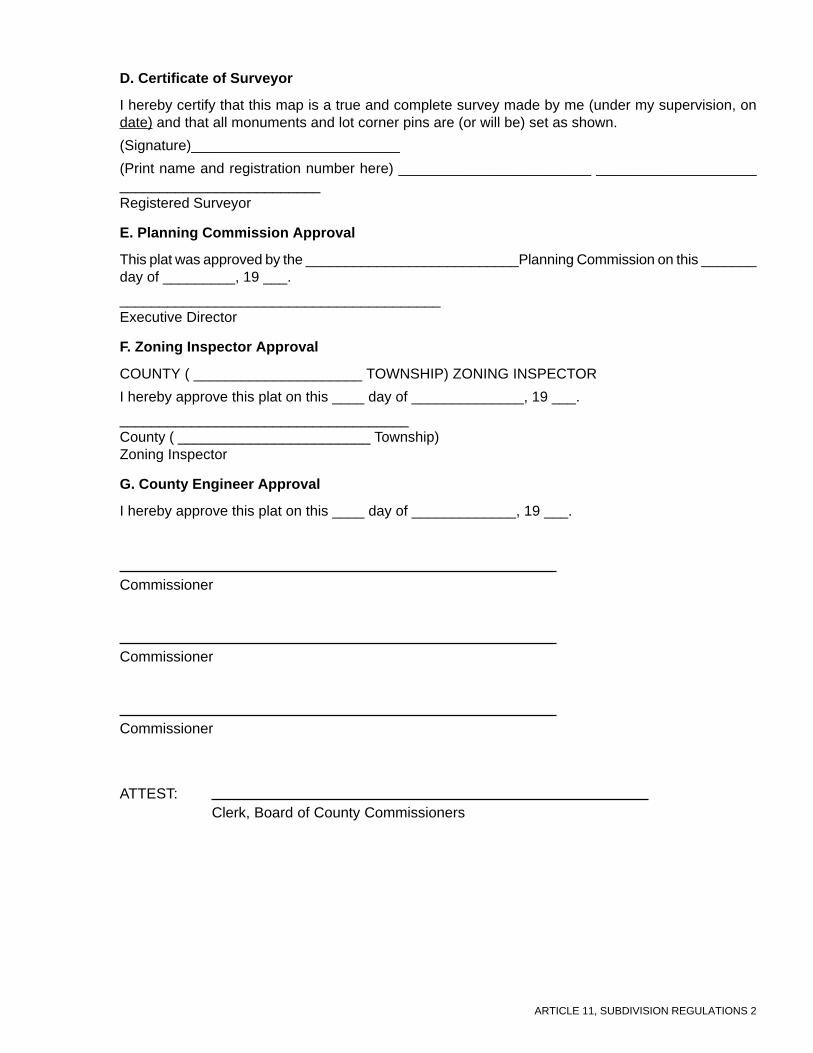
ARTICLE 11, SUBDIVISION REGULATIONS 2
D. Certificate of Surveyor
I hereby certify that this map is a true and complete survey made by me (under my supervision, ondate) and that all monuments and lot corner pins are (or will be) set as shown.
(Signature)__________________________
(Print name and registration number here) ________________________ _____________________________________________Registered Surveyor
E. Planning Commission Approval
This plat was approved by the ___________________________Planning Commission on this _______day of _________, 19 ___.
________________________________________Executive Director
F. Zoning Inspector Approval
COUNTY ( _____________________ TOWNSHIP) ZONING INSPECTOR
I hereby approve this plat on this ____ day of ______________, 19 ___.
____________________________________County ( ________________________ Township)Zoning Inspector
G. County Engineer Approval
I hereby approve this plat on this ____ day of _____________, 19 ___.
Commissioner
Commissioner
Commissioner
Clerk, Board of County CommissionersATTEST:
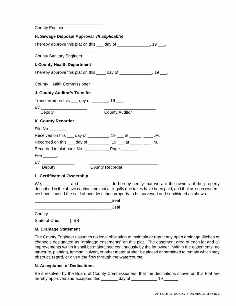
ARTICLE 11, SUBDIVISION REGULATIONS 3
_____________________________County Engineer
H. Sewage Disposal Approval (If applicable)
I hereby approve this plat on this ___ day of ______________, 19 ___.
_____________________________County Sanitary Engineer
I. County Health Department
I hereby approve this plat on this ____ day of ______________, 19 ___.
_______________________________County Health Commissioner
J. County Auditor’s Transfer
Transferred on this ___ day of _______, 19 ___.
By ____________________ ______________________ Deputy County Auditor
K. County Recorder
File No. _______
Received on this ___ day of _________, 19 ___ at _____ ____ .M.
Recorded on this ___ day of _________, 19 ___ at _____ ___ .M.
Recorded in plat book No. __________, Page _______.
Fee ______.
By ______________ _____________________________ Deputy County Recorder
L. Certificate of Ownership
We, ___________ and _____________ do hereby certify that we are the owners of the propertydescribed in the above caption and that all legally due taxes have been paid, and that as such owners,we have caused the said above described property to be surveyed and subdivided as shown.
_________________________________Seal
_________________________________Seal
County
State of Ohio, } SS
M. Drainage Statement
The County Engineer assumes no legal obligation to maintain or repair any open drainage ditches orchannels designated as “drainage easements” on this plat. The easement area of each lot and allimprovements within it shall be maintained continuously by the lot owner. Within the easements, nostructure, planting, fencing, culvert, or other material shall be placed or permitted to remain which mayobstruct, retard, or divert the flow through the watercourse.
N. Acceptance of Dedications
Be it resolved by the Board of County Commissioners, that the dedications shown on this Plat arehereby approved and accepted this _______ day of ___________ 19 ______

ARTICLE 12, SUBDIVISION REGULATIONS 1
Article 12DEFINITIONSA. Interpretation of Terms or Words
For the purpose of these Regulations, certain terms or words used herein shall be interpreted asfollows:
a. The word “person” includes a firm, association, organization, partnership, trust, company, orcorporation as well as an individual.
b. The present tense includes the future tense, the singular number includes the plural, and theplural number includes the singular.
c. The word “shall” is a mandatory requirement, the word “may” is a permissive requirement, andthe word “should” is a preferred requirement.
d. The words “used” or “occupied” include the words “intended, designed, or arranged to be usedor occupied.”
e. The word “lot” includes the words “plot or parcel.”
f. The word “County” where used shall mean the County adopting these Regulations and its legalentities.
B. GlossaryAlley: See Thoroughfare.
Block: That property abutting one side of a street and lying between the two nearest intersectingstreets, or between the nearest such street and railroad right-of-way, unsubdivided acreage, river orlive stream, or between any of the foregoing and any other barrier to the continuity of development.
Block Frontage: Property abutting on one side of a street, and lying between the two nearest inter-secting or intercepting streets, or between the nearest intersecting or intercepting street and railroadright-of-way, waterway, or other definite barrier.
Board: The board of county commissioners.
Building: A structure designed to be used as a place of occupancy, storage or shelter.
Building Site: A parcel under separate deed or description containing less than 5 acres and havingroad frontage.
Comprehensive Development Plan: A plan or any portion, thereof, adopted by the planning com-mission and the county commissioners showing the general location and extent of present and pro-posed physical facilities, including housing, industrial, and commercial uses, major streets, parks,schools, and other community facilities. This plan establishes the goals, objectives, and policies ofthe community.
Condominium: Condominium means and includes the land, together with all buildings, improve-ments, and structures thereon, all easements, rights and appurtenances belonging thereto, and allarticles of personal property which have been submitted to the provisions of Chapter 5311 of the OhioRevised Code and which is subject to said Chapter 5311.
Corner Lot: See Lot Types.
Covenant: A written promise or pledge.
Cul-de-sac: See Thoroughfare.
Culvert: A transverse drain that channels under a bridge, street, or driveway.
Dead-end Street: See Thoroughfare.
ARTICLE 12, SUBDIVISION REGULATIONS 2
Density: A unit of measurement; the number of dwelling units per acre of land.
Gross Density: the number of dwelling units per acre of the total land to be developed.
Net Density: the number of dwelling units per acre of land when the acreage involved includes onlythe land devoted to residential uses.
Density, Low Residential: Land to be utilized for residential purposes, including public housing, andindustrialized units, which does not exceed two (2) dwelling units per gross acres.
Density, Medium-Low Residential: Land to be utilized for residential purposes, including publichousing and industrialized units, which does not exceed four (4) dwelling units per gross acre. For thepurpose of street design requirements, the medium-low density residential classification shall be con-sidered as medium density.
Density, Medium Residential: Land to be utilized for residential purposes, including public housingand industrialized units, which does not exceed eight (8) dwelling units per gross acre.
Density, Medium-High Residential: Land to be utilized for residential purposes, including publichousing and industrialized units, which does not exceed sixteen (16) dwelling units per gross acre.For the purposes of street design requirements, the medium-high density residential classificationshall be considered as high density.
Density, High Residential: Land to be utilized for residential purposes, including public housing andindustrialized units, which does not exceed thirty-two (32) dwelling units per gross acre.
Develop: To make a development; also to do any grading or filling of land, whether undeveloped oralready subdivided, so as to change the drainage or the flow of water, or to do any work upon the landthat is capable of serving as a subdivision or development of building sites in the future.
Developer: Any individual, subdivider, firm association, syndicate, partnership, corporation, trust, orany other legal entity commencing proceedings under these regulations to effect a subdivision of landhereunder for himself or for another.
Driveway: A vehicular travelway used to provide access from a street to dwelling units or commercialor industrial activities. Driveways are designed for low travel speeds and are often used as, or areintegral with, parking areas for vehicles.
Dwelling Unit: Space within a building comprising living, dining, sleeping and storage rooms as wellas space and equipment for cooking, bathing, and toilet facilities, all used by only one (1) family andits household employees.
Easement: A grant by the property owner of the use of a strip of land by the public, a corporation, orother persons, for specified purposes.
Engineer: Any person registered to practice professional engineering by the state board of registra-tion as specified in Section 4733.14, Ohio Revised Code.
Environmental Protection Agency: Ohio Environmental Protection Agency (E.P.A.)
Erosion: The wearing away of the earth’s soil surface by water, wind, gravity, or any other naturalprocess.
FEMA: The Federal Emergency Management Agency.
Final Plat: A revised version of the preliminary plan showing exact locations of lot lines, rights-of-way, easements, and dedicated areas. The final plat is recorded in the office of the County Recorder.
Flood: An overflowing of water, from watercourses, onto land which is normally dry.
Flood, 100-Year: The temporary inundation of normally dry land areas by a flood that is likely to occuronce every 100 years (i.e., that has a one percent (1%) chance of occurring each year, although theflood may occur in any year.)
Flood Plain: Any land area susceptible to be inundated by water from the base flood. The term refersto that area designated as subject to flooding from the base flood (100-year flood) on the “Flood
ARTICLE 12, SUBDIVISION REGULATIONS 3
Boundary and Floodway Map” prepared by the U.S. Department of Housing and Urban Development.
Grade: The amount of rise or descent of a sloping land surface, usually measured as a percentwhere the numbered percent represents the amount of vertical rise or fall, in feet, for every 100 feethorizontally. For example, a one foot vertical rise over one hundred horizontal feet represents a onepercent slope.
Health Department: City-County Health District.
Highway Director: The Director of the Department of Transportation.
Improvements: Street pavement or resurfacing, curbs, gutters, sidewalks, water lines, sewer lines,storm drains, street lights, flood control for drainage facilities, utility lines, landscaping, and otherrelated matters normally associated with the development of raw land into building sites.
Land Contract: A legal agreement between a landowner and another person or persons interestedin purchasing real property owned by the landowner, wherein the landowner agrees to receive regularpayments, at specified intervals for a specified period of time, from the purchaser and at the end of thespecified time period agrees to transfer ownership of the property to the purchaser.
Letter of Credit: A written statement from a bank or loan company, written against the good standingof a developer, guaranteeing necessary funds, the amount to equal a professional engineer’s costestimate for subdivision improvements, to complete such improvements should the developer fail tocomplete them within the time frame and conditions as specified in the subdivision approval agree-ments. (See also, Performance Bond or Surety Bond)
Location Map: See Vicinity Map.
Lot: For purposes of these regulations, a lot is a parcel of land that is:a. A single lot of record;b. A portion of a lot of record;c. A combination of complete lots of record, of complete lots of record and portions of lots of
record, or of portions of lots of record.
Lot Area: The area of a lot computed exclusive of any portion of the right(s) of way of any public orprivate street.
Lot Depth: The mean horizontal distance between the front and rear lines of a lot.
Lot Frontage: The front of a lot shall be constructed to be the portion nearest the street. For thepurpose of determining yard requirements on corner lots and through lots, all sides of a lot adjacent tostreets shall be considered frontage, and yards shall be provided as indicated under Yards in thissection.
Lot Measurements: A lot shall be measured as follows:
a. Depth of a lot: The distance between the mid-points of straight lines connecting the foremostpoints of the side lot lines in front and the rearmost points of the side lot lines in the rear.
b. Width of a lot: The distance between straight lines connecting front and rear lot lines at eachside of the lot, measured at the building setback line, provided, however, that the width betweenside lot lines at their foremost points (where they intersect with the street line) shall not be lessthan eighty (80) percent of the required lot width.
Lot of Record: A lot which is part of a subdivision recorded in the office of the county recorder, or alot or parcel described by metes and bounds, the description of which has been so recorded.
Lot Types: Terminology used in these regulations with reference to corner lots, interior lots and throughlots is as follows:
a. Corner Lot: A lot located at the intersection of two or more streets. A lot abutting on a curvedstreet or streets shall be considered a corner lot if straight lines drawn from the foremost pointsof the side lot lines to the foremost point of the lot meet at an interior angle of less than onehundred thirty-five (135) degrees.
ARTICLE 12, SUBDIVISION REGULATIONS 4
b. Interior Lot: A lot other than a corner lot with only one frontage on a street.
c. Through Lot: A lot other than a corner lot with frontage on more than one street. Through lotsabutting two streets may be referred to as double frontage lots.
d. Reversed Frontage Lot: A lot on which frontage is at right angles to the general pattern in thearea. A reversed frontage lot may also be a corner lot.
e. Flag Lot: A lot whose only frontage on a public street is through a narrow strip of land which isgenerally wide enough to accommodate a driveway, but too narrow to accommodate any struc-tures. The narrow strip of land is referred to as the panhandle.
Lot Width: The horizontal distance between side lot lines measured along the required building set-back line. When the street line is curved, the measurement shall be made on the arc, on or parallel tothe curve of the street line.
Major Thoroughfare Plan: The Comprehensive Plan adopted by the County Regional PlanningCommission indicating the general location recommended for arterial, collector, and local thorough-fares within the unincorporated area of the county.
Maintenance Bond: An agreement by a subdivider or developer with the county guaranteeing themaintenance of physical improvements for a period of one (1) year from the release of the perfor-mance bond.
Minor Subdivision: A division of a parcel of land that does not require a plat to be approved by aplanning authority according to Section 711.131, Ohio Revised Code. Also known as Lot Split.
Monuments: Iron bases or iron pipes which will be set at all lot or parcel corners within the subdivi-sion.
Open Space: An area open to the sky which may be on the same lot with a building. The area mayinclude, along with the natural environmental features, swimming pools, tennis courts, and any otherrecreational facilities that the planning commission deems permissive. Streets, structures for habita-tion, and the like shall not be included.
Out Lot: Property shown on a subdivision plat outside of the boundaries of the land which is to bedeveloped and which is to be excluded from the development of the subdivision.
Owner: Any individual, firm, association, syndicate, co-partnership, corporation, trust or any otherlegal entity having sufficient proprietary interest in the land sought to be subdivided to commence andmaintain proceedings to subdivide the same under these Regulations.
Pad: A building site prepared by artificial means, including, but not limited to, grading, excavation, orfilling, or any combination thereof.
Parcel: Any piece of land described by a current deed.
Parking Space, Off-Street: For the purpose of these Regulations, an off-street parking space shallconsist of an area adequate for parking an automobile with room for opening doors on both sides,together with properly related access to a public street or alley and maneuvering room, but shall belocated totally outside of any street or alley right-of-way.
Performance Bond or Surety Bond: An agreement by a developer with the county for the amount ofthe estimated construction cost (as approved by county commissioners and county engineer) guaran-teeing the completion of physical improvements according to plans and specifications within the timeprescribed by the subdivider’s agreement. (See also, Letter of Credit)
Performance Guarantee: Any security that may be accepted by a municipality as a guarantee thatthe improvements required as part of an application for development that are satisfactorily completed.
Person: An individual, trustee, executor, other fiduciary, corporation, firm, partnership, association,organization, or other entity acting as a unit.
Planned Unit Development: An area of land, in which a variety of housing types and/or relatedcommercial and industrial facilities are accommodated in a pre-planned environment under more

ARTICLE 12, SUBDIVISION REGULATIONS 5
flexible standards, such as lot size and setbacks, than those restrictions that would normally applyunder these Regulations. The procedure for approval of such development contains requirements inaddition to those of the standard subdivision, such as building design principles and landscapingplans.
Plat: The map, drawing, or chart on which the developer’s subdivision is presented to the planningcommission for approval, to the county recorder (final) for recording.
Preliminary Plan: The initial proposal, including both narrative and site design information, intendedto provide the planning commission with an understanding of the manner in which the site in questionis to be developed.
Public Way: An alley, avenue, boulevard, bridge, channel, ditch, easement, expressway, freeway,highway, land, parkway, right-of-way, road, sidewalk, street, subway, tunnel, viaduct, walk, or otherways in which the general public entity have a right, or which are dedicated, whether improved or not.(See Right-of-Way)
Replat: A subdivision or plat, the site of which has heretofore been platted or subdivided with lots orparcels of land. It may include all or any part of a previous subdivision or plat.
Reserve Strip: An area of land adjacent to a public right-of-way which is retained in ownership by thesubdivider for the purpose of denying access to the adjacent land.
Right-of-Way: A strip of land taken or dedicated for use as a public way. In addition to the roadway,it normally incorporates the curbs, lawn strips, sidewalks, lighting and drainage facilities, and mayinclude special features (required by the topography of treatment) such as grade separation, land-scaped areas, viaducts, and bridges. (See Public Way)
Setback Line: A line established by the subdivision regulations generally parallel with and measuredfrom the lot line, defining the limits of a yard in which no building or structure, other than an accessorybuilding, may be located above ground.
Sewers, Central or Group: An approved sewage disposal system which provides a collection net-work and disposal system and central sewage treatment facility for a single development, communityor region.
Sewers, On-Site: A septic tank or similar installation on an individual lot which utilizes an aerobicbacteriological process, or an equally satisfactory process, for the elimination of sewage, and pro-vides for the proper and safe disposal of the effluent, subject to the approval of health and sanitationofficials having jurisdiction.
Sidewalk: That portion of the road right-of-way outside the roadway, which is improved for the use ofpedestrian traffic. See Walkway.
Sketch Plan: An informal drawing which shows how a developer proposes to subdivide a propertyand which gives sufficient site information for the planning commission representatives to offer sug-gestions for site development.
Slippage Potential: The potential which land has to move, under the force of gravity, should it bedisturbed during construction activity.
Stopping Sight Distance: The distance down a roadway for which a motorist is able to have unob-structed sight. Stopping sight distance is reduced by vertical and horizontal road curvature, fixedobjects on the side of the road, and overhanging vegetation.
Subdivider: Any individual, developer, firm, association, syndicate, partnership, corporation, trust, orany other legal entity commencing proceedings under these regulations to affect a subdivision of landhereunder for himself or for another.
Subdivision:
a. The division of any parcel of land shown as a unit or as contiguous units on the last precedingtax roll, into two (2) or more parcels, sites, or lots, any one of which is less than five (5) acres, for
ARTICLE 12, SUBDIVISION REGULATIONS 6
the purpose, whether immediate or future of transfer of ownership, provided, however, that thedivision or partition of land into parcels of more than five (5) acres not involving any new streetsor easements of access, and the sale or exchange of parcels between adjoining lot owners,where such sale or exchange of parcels between adjoining lot owners, where such sale orexchange does not create additional building sites, shall be exempted; or
b. The improvement of one or more parcels of land for residential, commercial, or industrial struc-tures or groups of structures involving the division or allocation of land for the opening, widen-ing, or extension of any street or streets except private streets serving industrial structures; thedivision or allocation of land as open spaces for common use by owners, occupants, or leaseholders, or as easements for the extension and maintenance of public sewer, water, storm drain-age, or other public facilities. (See Minor Subdivision)
Surveyor: Any person registered to practice surveying by the State Board of Registration as speci-fied in Section 4733.02, of the Ohio Revised Code.
Tract: The term is used interchangeably with the term lot, particularly in the context of subdivisions,where one “tract” is subdivided into several “lots.”
Technical Review Committee: A committee of representatives of the county engineer’s office, thecity/county health department, the planning commission, and the county planner who shall meet withdevelopers or property owners proposing a major subdivision, a commercial or industrial subdivision,or a minor subdivision on which a technical review member requires additional information. Thetechnical review committee shall offer advice and assistance to the planning commission.
Terrain Classification: Terrain within the entire area of the preliminary plat is classified as level,rolling, hilly, or hillside for street design purposes. The classifications are as follows:
a. Level: Land which has a cross slope range of four (4) percent or less;
b. Rolling: Land which has a cross slope range of more than four (4) percent but not more thaneight (8) percent;
c. Hilly: Land which has a cross slope range of more than eight (8) percent but not more thanfifteen (15) percent;
d. Hillside: Land which has a cross slope range of more than fifteen (15) percent.
Thoroughfare, Street, or Road: The full width between property lines bounding every dedicatedtravelway, with a part thereof to be used for vehicular traffic and designated as follows:
a. Alley: A minor street used primarily for vehicular service access to the back or side of proper-ties abutting on another street. Design speed is 10 miles per hour.
b. Arterial Street: A general term denoting a highway primarily for through traffic, carrying heavyloads and large volume of traffic, usually on a continuous route. Design speed is generally 55miles per hour.
c. Collector Street: A thoroughfare, whether within a residential, industrial, commercial, or othertype of development, which primarily carries traffic from local streets to arterial streets, includingthe principal entrance and circulation routes within residential subdivisions. Design speed isgenerally 35 miles per hour.
d. Cul-de-Sac: A local street of relatively short length with one (1) end open to traffic and the otherend terminating in a vehicular turnaround. Design speed is generally 25 miles per hour.
e. Dead-end Street: A street temporarily having only one (1) outlet for vehicular traffic and in-tended to be extended or continued in the future.
f. Local Street: A street primarily for providing access to residential, commercial, or other abut-ting property. Design speed is generally 25 miles per hour.
g. Loop Street: A type of local street each end of which terminated at an intersection with thesame arterial or collector street, and whose principal radius points of the one hundred and eighty

ARTICLE 12, SUBDIVISION REGULATIONS 7
(180) degree system of turns are not more than three thousand (3000) feet from said arterial orcollector street, nor normally more than six hundred (600) feet from each other.
h. Marginal Access Street: A local or collector street, parallel and adjacent to an arterial orcollector street, providing access to abutting properties and protection from arterial or collectorstreets. (Also called Frontage Street.)
Through Lot: See Lot Types.
Variance: A modification of the strict terms of the relevant regulations where such modification willnot be contrary to the public interest and where owing to conditions peculiar to the property and notthe result of the action of the applicant, a literal enforcement of the regulations would result in unnec-essary and undue hardship.
Vicinity Map: A drawing located on the plat which sets forth by dimensions or other means, therelationship of the proposed subdivision or use to other nearby developments or landmarks and com-munity facilities and services within the county in order to better locate and orient the area in question.
Watershed: The drainage basin in which the subdivision drains or that land whose drainage is af-fected by the subdivision.
Wetland: An area of land, as defined by the federal definition at the time of preliminary plan submis-sion, inundated by water for a portion of each year resulting in the land possessing unique soil andvegetative types.
Yard: A required open space other than a court unoccupied and unobstructed by any structure fromthree (3) feet above the general ground level of the graded lot upward, provided, accessories, orna-ments, and furniture may be permitted in any yard, subject to height limitations and requirementslimiting obstructions of visibility.
a. Yard, Front: A yard extending between side lot lines across the front of a lot and from the frontlot line to the front of the principal building.
b. Yard, Rear: A yard extending between side lot lines across the rear of a lot and from the rear lotline to the rear of the principal building.
c. Yard, Side: A yard extending from the principal building to the side lot line on both sides of theprincipal building between the lines establishing the front and rear yards.
Zoning Inspector: The zoning inspector of the county or township, appointed by the board of countycommissioners or the board of township trustees.

Article 13APPENDICESAppendix A - Schedule of Subdivision and Parcel Transfer Fees
LOT SPLITSOne lot (with more than 5 acres residue after splitting) $Two lots (with either 0 or more than 5 acres residue after splitting) $Lot line adjustment between parcels $
SUBDIVISION PLATTING
Sketch Plan/Site Reviewwith household sewage systems $with sanitary sewers $
Preliminary Planone/two family residential $other subdivision types $
Final Platone/two family residential $other subdivision types $
Note: If sketch plan and preliminary plan phases were not performed, the fee for the final plat will includethe fees that would have been charged for sketch plan and preliminary plan review
OTHER SUBDIVISION FEES
Preliminary Plan Amendment $
Final Plat Amendment $
Subdivision Appeal or Variance $
Inspection Rates per Hour $
Subscription to Planning Commission Agendas and Minutes $
County Subdivision Regulations Purchase $

Appendix B - Application for Minor Subdivision Approval
Pursuant to Ohio Revised Code 711.131
Five completed and executed copies of this application supplemented with applicable required infor-mation must be filed with the County or Regional Planning Commission. Such applications will beassigned a file number and sent to the office of County Engineer and Health Department for reviewand comments. A review for compliance with county and township zoning resolutions will also beconducted by the Planning Commission. Separate application shall be submitted for each lot subdi-vided. One copy of the application, together with the actions taken by the Planning Commission will bereturned to the applicant or his/her agent.
NAME OF APPLICANT OR AGENT___________________________________________________________
ADDRESS______________________________________________________________________________
CITY _______________ STATE___________ ZIP CODE____________ TELEPHONE________________
NAME OF GRANTOR_____________________________________________________________________
ADDRESS______________________________________________________________________________
CITY _______________ STATE___________ ZIP CODE____________ TELEPHONE________________
NAME OF GRANTOR____________________________________________________________________
ADDRESS______________________________________________________________________________
CITY _______________ STATE___________ ZIP CODE____________ TELEPHONE________________
Township in which transfer is to take place_____________________________________________________
Section__________________________ Size of Parcel__________________________________________
(For use of the County Engineer Only)
Date Received_______________________ Date Reviewed_____________________________
__________________________________________
County Engineer
Comments
______________________________________________________________________________________
______________________________________________________________________________________
______________________________________________________________________________________
SUBDIVISION REGULATIONS 2

(For Health Department Use Only)
Date Received_______________________ Date Reviewed_____________________________
Action: ________________________________________________________________________________
______________________________________________________________________________________
__________________________________________
Supervising Sanitarian
Comments
______________________________________________________________________________________
______________________________________________________________________________________
______________________________________________________________________________________
(For Use of the Planning Commission Only)
Date Received_______________________ Date Reviewed_____________________________
Action: ________________________________________________________________________________
______________________________________________________________________________________
Fees Due $ ____________
Fees Paid $ ____________
Date Paid ____________
Comments
______________________________________________________________________________________
______________________________________________________________________________________
______________________________________________________________________________________
__________________________________________
Director
SUBDIVISION REGULATIONS 3

Appendix C - Application for Major Subdivision Approval
NAME OF DEVELOPMENT
Sketch plan_________________________ Preliminary plan _________________ Final plat_____________
General Information:
Owner ________________________________________________________________________________
Address _______________________________________________________________________________
Phone: Home ____________________________ Business ____________________________________
Applicant ______________________________________________________________________________
Address _____________________________________________________________________________
Phone: Home ____________________________ Business ____________________________________
Engineer or Surveyor _____________________________________________________________________
Address _______________________________________________________________________________
Phone: Home ____________________________ Business ____________________________________
Development Data:
Location _______________________________________________________________________________
Existing Zoning _________________________________________________________________________
Proposed Use __________________________________________________________________________
Number of Lots _________________________________________________________________________
Total Acreage ___________________________________________________________________________
Minimum Lot Size _______________________________________________________________________
Linear Feet of New Street __________________________________________________________________
Water Supply: ________________ Public System ________________ On lot System ________________
Sewerage System: ____________ Public System ________________ On lot System ________________
SUBDIVISION REGULATIONS 4

ACTION:
Sketch Plan:
Comments _______________________________________________________________________________
____________________________________________________________________________________________
_____________________________________________________________________________________________
Preliminary Plan:
Approved: __________________________
Rejected: __________________________
Comments _______________________________________________________________________________
____________________________________________________________________________________________
_____________________________________________________________________________________________
Final Plat:
Approved: __________________________
Rejected: __________________________
Comments _______________________________________________________________________________
____________________________________________________________________________________________
_____________________________________________________________________________________________
Plat Recorded with County: __________________________________________________________________
Exhibits Submitted
_____ Sketch Design Plan
_____ Preliminary Plan
_____ Final Plan Feasibility Study
_____ Street Profile and Cross Sections
_____ Drainage Plan
_____ Performance Bond
_____ Deed Restrictions
_____ Other
(For Official Use Only)
Distribution of Plan
_____ County Engineer
_____ Dept. of Health
_____ Zoning Dept.
_____ Township
_____ ODOT
_____ OEPA
_____ Water Co.
_____ Sewer District
_____ School District
_____ Other
SUBDIVISION REGULATIONS 5

Appendix D - Application for Subdivision Variance
Date Application Prepared_________ Fee__________ Application Number ___________________
A variance is a modification of the strict terms of the relevant regulations where such modifications will not becontrary to the public interest and where, owing to conditions peculiar to the property and not the results of theaction of the applicant, a literal enforcement of the regulations would result in unnecessary and undue hard-ship.
APPLICANT NAME ______________________________________________________________________
ADDRESS______________________________________________________________________________
CITY ___________________ STATE_________ ZIP CODE___________ TELEPHONE________________
Location of property under consideration (Address and/or description):
_____________________________________________________________________________________________________________________________________________________________________
Nature of variance required: (Describe generally the nature of the variance)
___________________________________________________________________________________________________________________________________________________________________
Justification of variance: On a separate sheet, please attach a statement explaining why the variance fromrequirements of the subdivision regulation is required. Include such items as:
a. Exceptional topographical or other conditions peculiar to this particular parcel or land.
b. Why the strict interpretation of the regulations would deprive the applicant of rights enjoyed by otherproperty owners.
c. That the peculiar conditions do not result from previous actions of the applicant.
d. That the required variance is the minimum variance that will allow a reasonable division of the land.
e. A sketch of the area showing the location and characteristics of the requested variance.
I certify that all information contained in this application and its supplements is true and correct.
DATE________________________ SIGNATURE _____________________________________________
(For Official Use Only)
Date Application Received ____________________________________________________________
Planning Commission Action ___________________ Approved ___________ Disapproved ____________
Description of Action _______________________________________________________________________
__________________________________________________________________________________________________________________________________________________________________________________________________________________________
Fee Received: YES_____________ AMOUNT___________ NO___________________
Comments:_______________________________________________________________________________
__________________________________________________________________________________________
SUBDIVISION REGULATIONS 6

Appendix E - Preliminary Plan Checklist
Subdivision Name: _____________________________________________________________________
Owner: ________________________________________________________________________________
Reviewer: ______________________________________________________________________________
Date: __________________________________________________________________________________
The following items (do, do not) conform with the requirements of the _____________________ County Sub-division Regulations. Items not conforming are explained on the reverse side of this checklist.
Does Does Not Items
1. ______ ______ Application form complete
2. ______ ______ Variance application form complete (if necessary)
3. ______ ______ One original preliminary plan/appropriate # of copies complete
4. ______ ______ One set of preliminary subdivision improvement plans complete
5. ______ ______ Sheet size and map scale
6. ______ ______ Proposed name (no duplication) and location
7. ______ ______ Name, address, & phone # of owner, subdivider, professional engineer, andprofessional surveyor with appropriate numbers and seals
8. ______ ______ Scale of plat, north point, legend, and vicinity map of scale not less than 1”=2000’
9. ______ ______ Names of adjacent subdivisions, owners of adjoining parcels, and locationsof common boundary lines within 20 feet of the subdivision boundaries
10. ______ ______ Topographic contours (2 feet for <5% slopes, 5 feet for >5%-<15% slopes,and 10 feet for >15% slopes)
11. ______ ______ Locations, widths, and names of existing streets, railroad R/W’s, easements,parks, buildings, corporation and township lines, wooded areas, water courses,drainage patterns, water bodies, and topographic features within and aroundthe subdivision for 200 feet from its borders
12. ______ ______ Locations of floodways, floodplains, underground mines that may subject tosubsidence and other potentially hazardous areas
13. ______ ______ Locations of environmentally sensitive areas
14. ______ ______ Soil types from USDA soils map
15. ______ ______ Layout, numbers, dimensions of lots, and setback lines
16. ______ ______ Parcels reserved for public use or for use by residents of subdivision
17. ______ ______ Points of ingress/egress to the subdivision and locations of proposed futureaccess way locations for adjacent lands
18. ______ ______ Type of water supply and wastewater disposal systems, locations anddimensions of proposed utilities, utility easements, sewer lines, water mains,culverts, drainage tiles, or other underground utilities within or adjacent to thetract
SUBDIVISION REGULATIONS 7

ARTICLE 13, SUBDIVISION REGULATIONS 8
19. ______ ______ Locations of cemeteries, historical, or archaeological sites
20. ______ ______ Copy of proposed covenants and restrictions and an anticipated schedule ofconstruction
The following information does not apply to all subdivisions and may be requested during the preliminary planphase.
21. ______ ______ Statements of proposed use of lots with type and number of dwelling unitsand/or type of business or industry
22. ______ ______ Conceptual plan for commercial or industrial development showing proposedparking, loading areas, alleys, pedestrian walkways, streets, points of vehicu-lar ingress/egress to the development, and landscape features
23. ______ ______ Drawing of present and proposed grades and facilities for stormwater drain-age in cases where natural drainage is altered
24. ______ ______ Feasibility study on water and sewer facilities
25. ______ ______ Screening, buffering, and/or noise abatement measures
26. ______ ______ Cross sections and centerline profiles for each proposed street and prelimi-nary engineering designs for any bridges or culverts proposed in the project
27. ______ ______ Other information deemed necessary or prudent to create buildable sites or topromote the public health, safety, and welfare
SUBDIVISION REGULATIONS 8

ARTICLE 13, SUBDIVISION REGULATIONS 9
Appendix F - Final Plat Checklist
Subdivision Name: _________________________________________________________________
Owner: ____________________________________________________________________________
Reviewer: __________________________________________________________________________
Date: ______________________________________________________________________________
The following items (do, do not) conform with the requirements of the _____________________ County Sub-division Regulations. Items not conforming are explained on the reverse side of this checklist.
Does Does Not Items
1. ______ ______ Application form complete
2. ______ ______ Variance application form complete (if necessary)
3. ______ ______ One original final plat/appropriate # of copies complete
4. ______ ______ One original set of subdivision improvement plans and required # of copiescomplete with name, address and phone number of the professional engineerwith appropriate number and seal
5. ______ ______ Sheet size and map scale
6. ______ ______ Proposed name (no duplication) and location
7. ______ ______ Name, address, & phone # of owner, subdivider, and professional surveyorwith appropriate numbers and seals
8. ______ ______ Date of survey, scale of plat, north point, and acreage
9. ______ ______ Plat boundaries based on a field boundary survey, as defined in OhioAdministrative Code (OAC) 4733-37, all lot numbers and lines shown withaccurate dimensions in feet and hundredths
10. ______ ______ Building front, rear, and side setback lines with dimensions
11. ______ ______ Outline of areas to be dedicated or reserved for public use or common use bysubdivision residents and outlines of previous lots or blocks and their num-bers, indicated by a contrasting line style, in the case of a replat
12. ______ ______ Bearings and distances to the nearest established street lines and accuratelocation and description of all monuments
13. ______ ______ Names, locations, dimensions, rights-of-way of all existing and proposed streetsand railroads within and adjoining the plat. Radii, internal angles, points ofcurvature, tangent bearings, length of arcs, and lengths and bearing of chordsof all streets
14. ______ ______ Purposes, locations, and dimensions of all easements
15. ______ ______ Locations of all water bodies and flood hazard boundaries.
16. ______ ______ Base flood elevations have determined by a professional engineer when nec-essary
SUBDIVISION REGULATIONS 9
ARTICLE 13, SUBDIVISION REGULATIONS 10
17. ______ ______ The owners of record, acreage, deed book and page references for all abut-ting metes and bounds tracts and the names of all abutting subdivisions, withlot lines, lot numbers and plat book and page references
18. ____ ________ A copy of any restrictive covenants, and other notes, items, restrictions, orprovisions required by the subdivision regulations or the county
19. ____ ________ If a zoning change is involved, certification from the appropriate township orcounty zoning inspector
20. ____ ________ A letter from the permitting agency indicating that a driveway permit has beenissued or will be issued by the office of the county engineer, township trustees,or Ohio Department of Transportation on existing roads
21. ____ ________ Final plat was submitted within 12 months of preliminary plan approval
SUBDIVISION REGULATIONS 10
Does Does Not Items

ARTICLE 13, SUBDIVISION REGULATIONS 11
Appendix G - Subdivision Environmental Review Checklist
Subdivision Name: _________________________________________________________________________
Owner: __________________________________________________________________________________
Date: ___________________________________________________________________________________
The following questions should be answered as part of the sketch plan and preliminary plan process. Bygiving serious consideration to the issues posed by the questions, environmental problems posed by subdivi-sion creation can be minimized.
1. Does the subdivision conflict with any existing plans?
2. Does the subdivision affect the use of a recreation area, an area of important visualvalue, or preempt a site with potential recreation or open space value?
3. Will any unique natural or manmade features in the subdivision area be disturbed?
4. Do the engineering plans follow state-recommended guidelines for erosion control?
5. Do the engineering plans follow state-recommended guidelines for stormwater man-agement?
6. Do the engineering plans adequately protect against geologic hazards, particularly landslippage and unstable soils?
7. Does the subdivision change existing topography or involve construction on any flood-plain, natural drainage course, or watercourse? Are cuts and fills adequately engi-neered?
8. Is the subdivision one of a series of cumulative actions, which, although individuallysmall, may as a whole have significant environmental impact?
9. Does the subdivision area serve as a habitat, food source, nesting place, crossing,wintering area, source of water, etc. for any wildlife species?
10. Are there any rare or endangered plant species in the subdivision area?
11. Could the subdivision change existing features of any stream frontage or greenbeltareas?
12. Will the subdivision remove substantial amounts of vegetation, including ground cover?
13. Will the subdivision affect the hydrology of the region?
14. Will the subdivision serve to encourage development of presently undeveloped areasor intensify development of already developed areas? Have adequate measures beentaken to plan for this development?
15. Is there appreciable opposition to the subdivision or is it likely to be controversial?
16. Will the subdivision create new or aggravate existing health or safety hazards?
17. Will the subdivision generate significant amounts of dust or odor?
18. What will be the effects on traffic volumes and flow in the vicinity of the subdivision?
19. Will the subdivision contribute to the loss of agricultural land?
20. Have adequate measures been taken to minimize pollution of the air, water, and soil?Measures shall consider the subdivision’s future impacts of noise pollution; light pollu-tion; air pollution from dust; water pollution from chemical applications, soil erosion,and human effluent, and soil pollution from chemical applications and human efflu-ent.
___
___
___
___
___
___
___
___
___
___
___
___
___
___
___
___
___
___
___
___
Yes No___
___
___
___
___
___
___
___
___
___
___
___
___
___
___
___
___
___
___
___
SUBDIVISION REGULATIONS 11
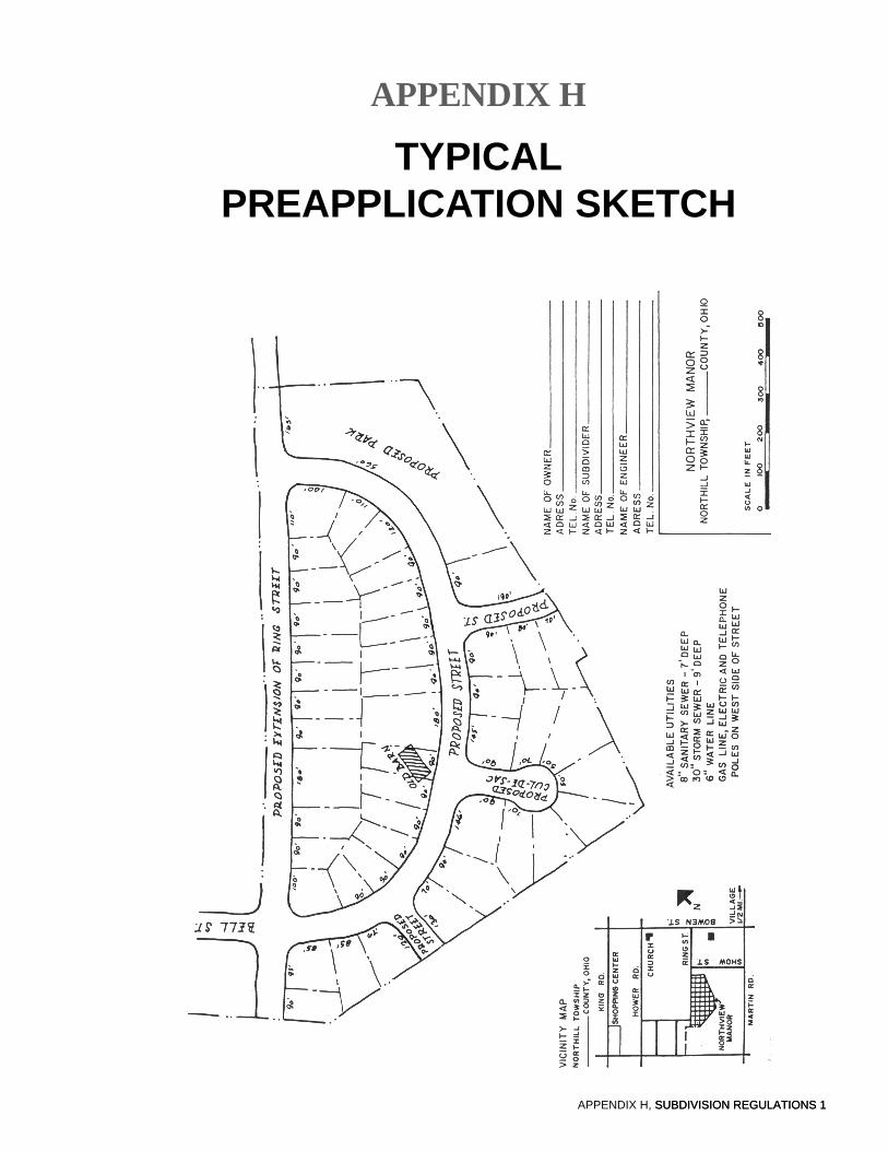
APPENDIX H, SUBDIVISION REGULATIONS 1
APPENDIX H
TYPICALPREAPPLICATION SKETCH
SUBDIVISION REGULATIONS 1

APPENDIX I, SUBDIVISION REGULATIONS 1
APPENDIX I
TYPICALPRELIMINARY SUBDIVISION PLAN

APPENDIX J 1
APPENDIX J
TYPICALFINAL SUBDIVISION PLAN