COULD WE CADASTER FASTER IN AN … · 2017 COULD WE CADASTER FASTER 379 will take an indefinite...
25
377 doi: 10.17265/1548-6605/2017.06.004 COULD WE CADASTER FASTER IN AN INTEGRATED IT SYSTEM BY USING UAVS WITH GIS SERVICES IN A CLOUD INFRASTRUCTURE? Mihnea Mihailescu , Diana Irimia , Răzvan Rădulescu & Răzvan Simion There is a significant number of geographies around the world where the percentage of land with cadaster and land books registered in an integrated IT system is rather low and increasing it is a real challenge for all stakeholders: the governmental institution managing the domain, surveyors, IT businesses and citizens. The typical duration and costs are too high for collecting all geospatial and deeds data, for all processing phases necessary before registering all data in a centralized IT system and issuance of land books. In order to improve the duration and costs of mass registration we analyze the involvement of modern technologies along the process, automation of eligible registration sub-processes, usage of UAVs for faster field data collection and storing and sharing all work in progress in the cloud infrastructure. We measure the improvements for each sub- process, analyze the impact of proposed actions, tools and environments, and quantify the duration, costs, quality and total cost of ownership for each scenario, based on simulations and prototype construction, to determine whether such improvements are a real “win” for all stakeholders. Comparing the mass registration process in several scenarios with different levels of automation on the sub-processes reveals a decrease of the duration or cost of sub-processes with 20-40%, a decrease in number of validation iterations with 25-50% and the improvement of public registration service transparency for the citizens. We argue that when such a technological improvements are applied to a large scale registration, the total cost of ownership of the IT system could be amortized early in the regstration process with a clear impact on the economy and public service quality of the registered geography. INTRODUCTION............................................................................................ 378 I. PROBLEM STATEMENT ............................................................................. 379 II. APPROACH .............................................................................................. 380 III. RESULTS ................................................................................................ 380 A. Assignment Preparation (Start-Up).......................................... 380 B. Data Collection and Processing ............................................... 384 Mihnea Mihailescu, Consultant in land management IT services sector. Email: [email protected]. Diana Irimia, Business Analyst in land management IT services sector. Răzvan Rădulescu, Subject Matter Expert in land management IT services sector. Răzvan Simion, Solution Architect in land management IT services sector.
Transcript of COULD WE CADASTER FASTER IN AN … · 2017 COULD WE CADASTER FASTER 379 will take an indefinite...
377 doi: 10.17265/1548-6605/2017.06.004
COULD WE CADASTER FASTER IN AN INTEGRATED
IT SYSTEM BY USING UAVS WITH GIS SERVICES IN
A CLOUD INFRASTRUCTURE?
Mihnea Mihailescu, Diana Irimia
,
Răzvan Rădulescu
& Răzvan Simion
There is a significant number of geographies around the world where
the percentage of land with cadaster and land books registered in an
integrated IT system is rather low and increasing it is a real challenge for
all stakeholders: the governmental institution managing the domain,
surveyors, IT businesses and citizens. The typical duration and costs are too
high for collecting all geospatial and deeds data, for all processing phases
necessary before registering all data in a centralized IT system and
issuance of land books. In order to improve the duration and costs of mass
registration we analyze the involvement of modern technologies along the
process, automation of eligible registration sub-processes, usage of UAVs
for faster field data collection and storing and sharing all work in progress
in the cloud infrastructure. We measure the improvements for each sub-
process, analyze the impact of proposed actions, tools and environments,
and quantify the duration, costs, quality and total cost of ownership for
each scenario, based on simulations and prototype construction, to
determine whether such improvements are a real “win” for all stakeholders.
Comparing the mass registration process in several scenarios with different
levels of automation on the sub-processes reveals a decrease of the
duration or cost of sub-processes with 20-40%, a decrease in number of
validation iterations with 25-50% and the improvement of public
registration service transparency for the citizens. We argue that when such
a technological improvements are applied to a large scale registration, the
total cost of ownership of the IT system could be amortized early in the
regstration process with a clear impact on the economy and public service
quality of the registered geography.
INTRODUCTION ............................................................................................ 378
I. PROBLEM STATEMENT ............................................................................. 379
II. APPROACH .............................................................................................. 380
III. RESULTS ................................................................................................ 380
A. Assignment Preparation (Start-Up) .......................................... 380
B. Data Collection and Processing ............................................... 384
Mihnea Mihailescu, Consultant in land management IT services sector. Email:
[email protected]. Diana Irimia, Business Analyst in land management IT services sector. Răzvan Rădulescu, Subject Matter Expert in land management IT services sector. Răzvan Simion, Solution Architect in land management IT services sector.

378 US-CHINA LAW REVIEW Vol. 14: 377
C. Data Validation ........................................................................ 390
D. Public Display .......................................................................... 392
E. Phase 6: Issuing of Land Books ............................................... 394
IV. CONCLUSIONS ....................................................................................... 395
V. OUR LAND MANAGEMENT SOFTWARE PRODUCT ................................... 396
VI. LAND ADMINISTRATION IMPACT ON THE GOVERNMENTAL ECOSYSTEM
.................................................................................................................... 398
A. Land Valuation and Taxation ................................................... 398
B. Emergency Management .......................................................... 400
INTRODUCTION
Over the history, land has proved to be one of the most important
resources that played a major role in the evolution of our species, as it
offered the ingredients the human kind needed to survive and develop: food,
construction materials, minerals etc. Due to these, it still represents an
endless source of disputes of diverse magnitudes and impacts.
Tribes, communities, societies have developed faster as they found
more efficient ways to manage land. From finding better tools and
techniques to work land in order to produce food, the concept of land
management has continuously evolved; nowadays more efficient politics in
poverty reduction, sustainable urbanization, climate change government,
equity assurance represent the current challenges. However, due to unequal
development of communities around the world, all types of needs, from
basic to sophisticated, are present on the public agendas of local
administrations, governments, international institutions.
Land registration is the process of official identification and recording
of the property boundaries, rights, restrictions and responsibilities through
deeds or title. It is regularly conducted by central or local public authorities.
Land registration represents the main pillar of land administration as it is
commonly accepted that is difficult to manage the “unknown”.
All around the world, governments are looking into implementing or
continuously optimizing and adapting their land registration systems, as
economic and social needs are rapidly changing. As many developing
countries are dealing with budgetary restrictions, the need of self-sustainable
solutions is a constant challenge.
In many countries, individual, on-the-need basis land registration
represents the initial and still most used process. It responds to the urgent
needs of the parties that can afford to pay its price. Even if the government
facilitates the individual registration by offering fee and/or tax discounts, it

2017 COULD WE CADASTER FASTER 379
will take an indefinite time to complete the registration and to obtain fair
quality data (ex. gaps and overlaps may probably occur).
Mass or systematic registration is the alternative to individual
registration process. It is usually run or supervised within programs by local
or central public authorities who can afford to support the cost, to manage
the complexity, to offer the legal, procedural and technical frameworks that
proved to be compulsory ingredients to success.
The design and preparation stage of these programs is probably the
most important time to address the potential systemic problems as legal
framework ambiguities, poor data quality of property documents (e.x. titles),
incomplete project procedures and insufficient training material and courses.
Experience has shown that ill prepared programs not only fail but they use
up the goodwill and enthusiasm that are essential for the success of a mass
campaign, such as systematic registration.1
I. PROBLEM STATEMENT
Mass registration process is probably the most efficient way to obtain a
complete cadastral map and property rights (restrictions, responsibilities)
registry for certain geography, in a time frame that is considered acceptable
in the current world landscape.
The process complexity can be evaluated as high considering its
following characteristics:
diverse types of stakeholders (citizen, companies, surveyors, public
authorities) in terms of culture, communication habits, institutional relations,
knowledge and understanding of laws and procedures;
massive data management of various type, quality, availability;
extremely important results for the further development of the socio-
economic environment.
IT companies and domain experts are striving to find ways to connect
the technological boom of the last decades with the development of
systematic registration by finding the appropriate IT solutions to key
business problems.
The target of our study is to explore ways of optimizing this process
from a technology-based perspective, by assessing the impact of the
proposed solutions to the quality and total cost of ownership, to determine
whether such improvements are a real “win” for all stakeholders.
1 Systematic Property Registration: Risks and Remedies (2016),
https://openknowledge.worldbank.org/handle/10986/26048.
380 US-CHINA LAW REVIEW Vol. 14: 377
II. APPROACH
Our methodology is to study each phase of systematic registration
process in order to identify activities that can be supported by an IT solution,
to validate their effectiveness through the analysis of the results of the
projects that used such or similar solutions or simulated scenarios.
The most common phases of the mass registration process are:
assignment preparation;
data collection and processing;
data validation;
public display and complaint management;
issuing of registration certificate.
We have identified these phases based our experience and analysis of
the available mass registration methodology.
Figure 1 Phases of a standard mass registration process.
The following chapter presents the analysis of each phase activities and
the solutions we have identified to improve the duration, effort or cost.
III. RESULTS
A. Assignment Preparation (Start-Up)
This is the initiation phase when the communication, procedural,
technical infrastructure of the project are setup.
1. Communication Infrastructure Setup
An efficient mass land registration process requires a good
collaboration between all involved parties that can be achieved using
effective information dissemination tools and methods to inform the
stakeholders about their requested involvement and benefits, the procedures
they have to comply with, to facilitate their communication, to push alerts
and reminders in order to avoid side slips.
In our opinion all of these can be enabled by an efficient

2017 COULD WE CADASTER FASTER 381
communication platform based on modern technology—a Project Portal.
The uploaded content may address:
project plan: activities, milestones, owners;
simplified version of procedures, grouped by activity and/or role in-
charge;
dashboards with the evolution of main project indicators (ex.
surveyed parcels, interviewed persons);
events which trigger alerts/reminders: milestone approaching, delays
in delivery, rejection of critical areas during validation phases which
requires immediate corrections etc;
templates of documents;
contact information of involved institution representatives.
Figure 2 Citizen Portal.
The solution implementation analysis should consider some key
attributes of the audience such as: cultural patterns, computer literacy level
and internet penetration rate as the success of adaption is highly dependent
on these. The result of this analysis should determine the adequate level of
formalization, access and communication methods to be used (ex. sms,
email) in order to maximize the capabilities of this tool.
In conclusion, the implementation of this modern communication tool
may represent an improvement to the general process if the target audience
possesses the required minimum technical and educational level. In that case,
we consider it may be a reliable and efficient communication channel and a
good alternative to the traditional one which is based on direct human
interaction, information exchanged on paper, centralized and controlled by
local (administrative) authorities.
2. Data Infrastructure Setup
The mass registration process is characterized by intensive data

382 US-CHINA LAW REVIEW Vol. 14: 377
management activities: collection, aggregation analysis, processing,
displaying operations are (sometimes) repeatedly performed. Impressive
volumes of scatter, incomplete, various types of data represent inputs that
generate high processing whenever they are manually, redundantly,
insecurely handled. Additional costs may occur if information is exchanged
on paper: material, transportation, cover of eventual losses.
3. Legacy Data
Essential data is usually hosted and managed by different public
authorities. Cadastral maps, enviromental plans, taxation zoning,
urbanization plans etc. should be centralized, cleansed, analysed and
spatially indexed in order to serve the project scope. Similar approach
should be followed with respect to alfanumeric data registries: titles,
taxation units etc.
For legacy data which rests on paper, a cost-benefit analysis may
conclude that the digitalization of the legacy registry certificates (land books,
land cards), property documents and map archives should be run to speed up
the data collection phase activities.
The duration of such projects depends on factors like the quality of the
scanned paper, the overall performance of the equipment, the organization
of the scanning activity (workflow), the experience of the human operator,
the involement of the beneficiary in the preparation phase etc.
Our case study is the digitization process of land books. A number of
80,000 land books with an average number of 9 pages were scanned with a
speed of 2,800 pages per hour in less than 2 months. The resulted digital
archive was used in the mass registration process managed by the local
administration (City Hall).
In our opinion, it is important that legacy data are checked for
inconsistencies and the major findings are fixed before sharing it with the
involved parties. A special attention should be paid to “property-proof”
documents like titles in case they represent the baseline for mass registration
process. They should be digitized, their main attributes value should be
stored into a database and cleansed using consistency check algorithms and
correlations with other property-related data repositories, such as taxation
database.
Based on our expericence on the analysis of over 10,000 parcels we
can say that around 15% of the corresponding property titles contain data
completion (typos) or corellation (totals) errors. The manual validation of
the title main attribute value (cadastral identifier, parcel area) for each parcel

2017 COULD WE CADASTER FASTER 383
may take up to 10-15 minutes per parcel which leads to 200-300 working
days. We estimate that reducing the error occurences in title-related data
with 25% may improve the data collection activity that consists of spatial—
property title data paring with 20-30% in terms of effort.
Our proposed solution for managing legacy data is an IT platform
which has the appropriate tools to:
import and remotely access external data exposed in standard
formats (services);
consolidate and index data of different types on regular basis;
facilitate data cleasing by data correlation tools;
offer data interrogation via internal user interfaces or services.
The core components of the solution are represented by:
an alphanumeric engine that features full-text search, hit highlighting,
faceted search, real-time indexing, dynamic clustering and rich document
handling;
an spatial engine that runs advanced queries on internal and external
sources exposed in standard formats, can manage huge data caches, may
generate analytical reports based on real-time identified spatial data
relations.
Figure 3 Legacy Data Platform.
The data managed by the platform should be organized around the two
main pillars of land registration: the property and the parties which hold
rights, responsibilities or which are restricted to perform actions in relation
to a specific property. The main goal of the data platorm is to provide
consolidated, fairly realiable, easy accessible, baseline data for supporting
the project publicity and field visits.

384 US-CHINA LAW REVIEW Vol. 14: 377
B. Data Collection and Processing
This phase is characterized by extensive field activities conducted by a
team (private surveyor company, public cadastre institution) which is
responsible for interviewing, surveying and collecting ownership-related
documents from citizens and companies.
1. Cadastral Mapping
The cadastral mapping activity is currently benefiting a lot from the
huge development of the “unmanned aerial vehicles (UAVs), commonly
known as drones. These commercial drones are small and feather-light.
They offer a turnaround mapping service from planning to product in a
matter of days or weeks rather than months or a year and at a fraction of the
cost of conventional aerial surveying using manned aircraft”2.
These advances were possible due to the rapid development of
specialized software algorithmes that enabled the tessellation of
aerophotograms taken by non-metric cameras with very good results in
terms of precision.
Our case study to prove that “this new approach significantly reduces
the cost and time for high quality cadastral mapping”3 is based on the
following figures.
Table 1 Technical Parameters.
UAV HIRRUS4
Cruise speed 90 km/h
Wigspan 3.3 m
Range 15 km
Altitude (max) 3,000 m
Autonomy 3 h
Get-off system Launching platform
Landing system Air-drop
Load (max) 0.9 kg
Camera Sony Nex 7 (https://en.wikipedia.org/wiki/Sony_NEX-7)
24 MegaPixel, 30 mm
2 WORLD BANK GROUP, DRONES OFFER INNOVATIVE SOLUTION FOR LOCAL MAPPING (Washington DC
2016), http://www.worldbank.org/en/news/feature/2016/01/07/drones-offer-innovative-solution-for-
local-mapping. 3 WORLD BANK GROUP, DRONES OFFER INNOVATIVE SOLUTION FOR LOCAL MAPPING (Washington DC
2016), http://www.worldbank.org/en/news/feature/2016/01/07/drones-offer-innovative-solution-for-
local-mapping. 4 HIRRUS is a trademark of a research project between Autonomous Flight Technologies, www.aft.ro
and Teamnet International, www.teamnet.ro.

2017 COULD WE CADASTER FASTER 385
Table 2 Flying Plan, Data Collection and Processing Parameters. Overflight 2,600 ha
Landmarks 30 points
Flying bands coverage 60% (min)
Check pointssurvey GPS Trimble Geo 7x, real time kinematic mode
Figure 4 Flying plan.
Figure 5 Photogram coverage.
386 US-CHINA LAW REVIEW Vol. 14: 377
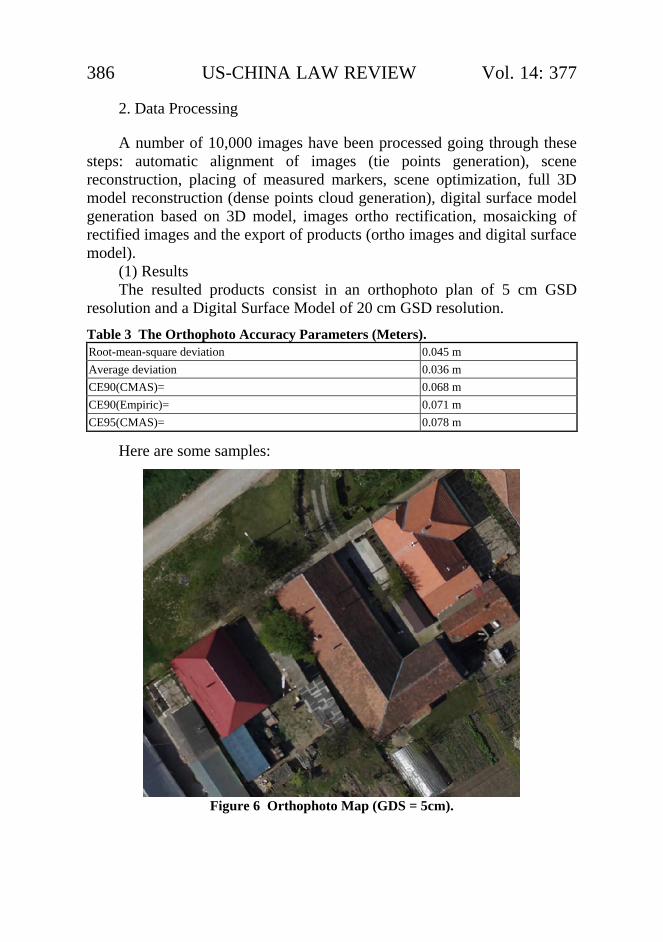
2. Data Processing
A number of 10,000 images have been processed going through these
steps: automatic alignment of images (tie points generation), scene
reconstruction, placing of measured markers, scene optimization, full 3D
model reconstruction (dense points cloud generation), digital surface model
generation based on 3D model, images ortho rectification, mosaicking of
rectified images and the export of products (ortho images and digital surface
model).
(1) Results
The resulted products consist in an orthophoto plan of 5 cm GSD
resolution and a Digital Surface Model of 20 cm GSD resolution.
Table 3 The Orthophoto Accuracy Parameters (Meters).
Root-mean-square deviation 0.045 m
Average deviation 0.036 m
CE90(CMAS)= 0.068 m
CE90(Empiric)= 0.071 m
CE95(CMAS)= 0.078 m
Here are some samples:
Figure 6 Orthophoto Map (GDS = 5cm).

2017 COULD WE CADASTER FASTER 387
Figure 7 Digital Surface Model (GDS 20 cm).
We have measured the vectorizing effort of around 0.5-1 hour per land
parcel, including the field validation work which is absolutely necessary for
boundaries which cannot be drawn from the office due to visual obstacles
(ex. vegetation, clouds) etc.
Figure 8 Cadastral Map.
(2) Conclusion
The precision of the ortho photo map recommends the use of the
products derived from UAV-collected aerial images for a variety of areas in
particular the systematic registration of lands, urban, infrastructure and
utilities planning, land use monitoring etc. It will reduce time and lower
costs at a reasonable quality of the final product.

388 US-CHINA LAW REVIEW Vol. 14: 377
2. Field Visit Management
The activities of this resource consuming phase can be optimized by
facilitating the organization, capturing and exchange of data between the
ground-based and office-based teams.
Below are briefly presented some improvements which can speed up
the process by using a dedicated (mobile) application connected to a central
server:
team structure and the optimized routes of the areas to be visited can
be defined beforehand, using specialized features;
team members may access online or check-out for offline use
essential spatial and alphanumeric data for the allocated visit areas;
list of persons and immovables with a selected list of atributes;
customized interview forms, prefilled with identification data for
parcels, parties and legacy property documents;
the parcelor the address of the person to be interviewed can be
located using GPS technology depending on availability;
the interview results can be directly input into the mobile application
along with the photocopy of the ownership-related documents;
the field-collected spatial vector data can be rapidly transferred to
the central system by interconnecting the total stations with the mobile
application.
Figure 9 “Field Assistant” Mobile Application.
Our study, based on interviews with surveyor team leaders, show the
following improvements in the scenario of using the above mentioned
features:
the effort related to team allocation activity will decrease by 50-60%;
the preparation of the interview (per land parcel) will be reduced by
30-50% from 30 to 15 minutes;
the filling of interview form and property documentation
photocopying duration (per land parcel) will decrease by 50-75% from 20
minutes to 5-10 minutes;

2017 COULD WE CADASTER FASTER 389
the collected data transfer per cadastral zoning (cadastral sector) will
decrese by 33-50% from 3 days to less then 2 days, considering the paper-
based information cannot be excluded from this activity.
The above figures are highly dependent on the methodology required
by the project, the experience of the team members and performance and
availability of internet connection etc.
3. Data Processing
This activity is dedicated to the management of collected data (spatial,
alphanumeric and fotocopies): consolidation, processing, validation,
correction, transformation and export. All these operations are successively
and repeatedly applied in order to meet the quality standards required by the
beneficiary authority.
Our proposed solution is a set of capabilities provided by an IT
application to assist the surveyor in the manipulation and validation of the
collected data. It can be seamlessly integrated with the application we have
proposed for data collection to ensure a smooth data feed from collection to
processing operations.
This application may offer the following set of features:
import of various spatial data file formats;
enhanced data entry capabilites for capturing alphanumeric property
description and right-related data;
import of standard format documents (pdf): field interview sheets,
property documents, building unit blueprints;
advanced querying focused on modern text search capabilities;
integration of external spatial data sources (standard file and service
formats) and real-time spatial interrogation;
manual and automated triggered validations based on a configurable
business rule engine for both spatial and alphanumeric data;
quantitative and qualitative data evaluation reports;
generation of specialized reports like: cadastral plan, land parcel and
building index, owners’ index;
export of spatial data and associated right registrations in an XML
format transport file (standards may be used: i.e. GML).

390 US-CHINA LAW REVIEW Vol. 14: 377
Figure 10 Data Processing.
The surveyor team leaders we have interviewed during this case study
emphasized that this bundle of features will reduce the data processing
effort by 20-30%. They consider the business rule engine, evaluation reports
and XML transport file generator to be tools which will improve most their
data processing and packaging activity.
4. Services from Cloud
The implementation and further administration of the proposed IT
solutions for field data collection and processing may engage a total cost of
ownership which cannot be profitably absorbed by small and medium
surveying companies.
A more increasingly adopted solution is to access such IT capabilities
as software services provided via an SaaS software distribution model in
which the provider makes available its application capabilities via an
internet platform that serves as a host. This contracting approach lowers the
capital expeditures of the service beneficiary and ensures a flexible business
relation with the provider. High availability, strong performance and
security are becoming standard characteristics of SaaS.
In conclusion, this contracting model should be an alternative not to be
missed in the planning of IT capabilities acquisition or distribution.
C. Data Validation
The activities of this phase are targeted to validate the high volumes of
the collected data against the content of the corresponding ownership-
related documents and a set of pre-defined business rules which address the
structure, correlation and completeness.
As systematic registration deals with volumes of cadastral unit (parcel,
immovable etc.) data which belong to the same superior zoning, mass
validations are required at least for topological reasons. The huge amount of

2017 COULD WE CADASTER FASTER 391
data needs to be verified in a rather short period of time as it is presumed it
may change in real life due to nature, owner’s or authority’s will.
Our proposed solution to improve the activities of this phase consists
inan information system which features capabilities for:
1. Data Exchange
The transfer of the collected data can be done using:
(a) Edicated user interface which offers to surveyor operators all
necessary features to directly input and real-time validate data into the
beneficiary system;
(b) transport file format for spatial data, alphanumeric data or both,
based on standard international formats (i.e. GML);
(c) specialized service interface which enables secure and quality
controlled data transfer between surveyor and beneficiary systems.
The last two options may be preffered by large surveying companies
which possess the requested technical capabilities to (directly) connect their
system to benecifiary system, whereas the small ones and individual
surveyors may follow the first two options which requireless expertise in IT
solution and lower costs.
2. Data Validation
It is better to start the validation as soon as possible along the process
in order to provide feedback which can be faster incorporated into the
deliverables. Considering this, the information system should integrate data
validation in data transfer methods: data entry forms (client side), technical
specification of transportation file format (xsd) and web services (server-
side) and it should offer easy-to-access result validation reports and alerts.
As soon as data is transferred, the electronic validation operations may
be manually or automatically triggered based on the rules managed though a
business rule engine:
alphanumeric data is scanned to detect any deviations;
topological relations are checked using spatial features.
Both provider and beneficiary users can be authorized to perform data
transfer (where applicable) and validation activities within the platform, so
that data updates are performed faster and real-time official feedback is
accessible be all parties involved. This will reduce the overall number of
data production/correction—transfer validation iterations which will
consequently shorten the duration of data validation phase.
The system can offer sampling mechanisms to select the data which

392 US-CHINA LAW REVIEW Vol. 14: 377
has to be visually checked against the content of the field-collected or other
legacy documents. This approach will increase trust and lower the
possibility of the validation operators to commit abuses by applying the
same rules to all cases.
The validation decisions (approval, rejection) and progress (how many)
should be transparently shared to all involved parties in order to rapidly find
solutions and to apply corrections. Communication platform may be used to
triggeralerts and to push reminders. Cadastral map, built-in and custom
reports should be available to disseminate relevant information.
Figure 11 Data Validation.
The results of the question naire-based study show that a transparent
validation process, based on an IT platform which interconnects data
providers (surveyors) and beneficiaries (land registration office specialists)
and provides a common tool set for data exploration and validation is highly
appreciated by the involed parties. The main arguments are:
A fair treatment as the validation tools and result reports are
accessible to each side;
The standardization of the validation procedure by continuous
integration of the solutions to the exceptional cases;
The reduction of thecorection-validation iterations with 2-4 weeks
per delivery (cadastral sector) as the surveyor can initiate the correction
operations as soon as the rejection motivation is registered.
D. Public Display
The traditional public display procedure based on printed cadastral
plans, property and owner oriented indexes, called cadastral technical
documents, which are usually pinned on boards located at City Halls or
Cadastre/Land Registry Offices will continue to be primarly used as it is the
only format of presentation that’s accessible to large masses of people.

2017 COULD WE CADASTER FASTER 393
In regions where internet penetration has a good rate, the public display
can be supplementary realized in a digital environment.
Our improvement proposal is an IT system component which provides
the following features:
Cadastral technical documentation rendering in printable format;
Automated websites generation to present cadastral map, associated
property rights, restrictions and responsibilities (if registered) and the copies
of the collected documents (where available);
Dedicated online forms for capturing user disputes in relation with
property boundaries, attributes and right registrations and to upload relevant
documents;
Automatic generated messages to inform about the dispute
solutioning progress;
User registration and authorization workflow.
Figure 12 Public Display.
The feature which offers to the project leading authority the possibilty
to generate the final version of the cadastral map and property registries at
the end of the validation phase is considered a major process improvement
by the surveyor team leaders we have questioned. This way, the validated
data set is the only, secure, official source for the printed systematic
registration documents which are displayed on the local authority boards
and the website which facilitates the remote interaction with the owners who
cannot be present onsitefrom various reasons (distance, illness etc.) to
visually check the displayed information. They estimate this feature may
determine a decrease with 30-50% of the effort associated with the
management of these documents (intermmediate incorporation of fixes and
deliveries).
Online registration and real-time information of the disputes facilitates
the early start of the investigation and correction activities and ensure a
transparent and collaborative environment for the entities which have to
address the reported issues. From our respondents point of view, this is so

394 US-CHINA LAW REVIEW Vol. 14: 377
important as the major data inconsistencies, usually related to the mapping
discrepancies between the field reality and property documents, are
addressed within this phase.
E. Phase 6: Issuing of Land Books
At the end of the display phase, the public validated data which
incorporates the disputes’ resolution is uploaded into the land management
system (Cadaster Registry, Land Registry) and the document which
represents the evidence of registration is issued.
The data specification used within mass registration process should be
compatible with the one implemented by land registration management
system in order to ensure a smoother transfer of data.
It is vital that the cadastral/land registry authority has an electronic land
registration system so that the results of the mass registration project will be
further dinamically updated to reflect the changes which occur in real life
related to property boudaries (natural alterations: floods, river course
changes, landslides) and rights (transfer of property rights etc.).
The registration certificate (land book, land card, excerpt etc.) is
usually issued within the land book registration system as it provides such
built-in functionality by default.
Our proposal in terms of improvement is an integrated solution which:
Connects systematic registration solution with the core land
registration management system;
Offers mass registration certificates generation capabilities (merged
PDFs);
Integrates with external systems (i.e. Citizen Portal) via web services
to facilitate automatic or self-service distribution of e-signed electronic
version of registration certificates.
Figure 13 Mass Registration Process Finalization.

2017 COULD WE CADASTER FASTER 395
The practical adoption of the mass document generation and printing of
the registration certificates (cadastral plan excerpt, land book excerpt) will
reduce the average duration of obtaining the printed copy to seconds per
certificate (average no. of pages/document: 2).
A server signed e-version of these documents can be downloaded by
citizens and official representatives of the companies as long as they have an
authorized account and are registered as owners or other property right
holders. They can make use of this electronic copy as long as the required
legal framework is enforced, therefore the potential recipients officially
recognize its legal value.
IV. CONCLUSIONS
Nowadays, the systematic registration process can be more efficiently
addressed by integrating modern data collection technologies, software
capabilities, specific knowledge within the process. A detailed analysis of
each phase is compulsory to understand the specific needs, select the right
IT solutions and adapt them to match the requirements, integrate and tune
the entire system in order to maximize the results of its support in day to day
business outcome.
The solutions we have presented for each phase generate the highest
added value when they are integrated to act together as a system. The image
below offers the big picture: stakeholders, components and data flows.
Figure 14 Mass Registration Ecosystem.

396 US-CHINA LAW REVIEW Vol. 14: 377
The adoption of such a system is a complex, iterative process itself that
may require piloting phases followed by the deployment of the components
which may add the highest value to current landscape.
Our estimations show that an average improvement of duration or
effort with 20-40% is achievable. Its scale differs from phase to phase and it
is dependent to the level of automatization. The implementation of real-time
access to data validation decisions and citizen complaints may reduce the
number of validation iterations with 25-50%.
Communication and collaboration tools are essential components in the
current social environment as the need of information is continuously
increasing driven by the technological boom. A smoother and more
transparent access to information related to the property registration process
will trigger an increase of population trust, involvement and general
satisfaction.
We would like to take this opportunity to introduce our Cadaster and
Land Management technology expertise. We are a top IT company in
Romania, with presence in Europe, Middle East and Africa. We provide
complex IT systems’ integration projects and proven product suites in areas
of Land Management, Healthcare and Smart Cities, with more than 100
years of cumulated cadaster and land management IT services experience in
our team.
V. OUR LAND MANAGEMENT SOFTWARE PRODUCT
Our Cadastral Software Product is a suite of Integrated Land
Management Applications which provides complete services for the
management of cadastral and land book information. The solution
automates all cadastral and land registry data updates and legal outputs.
Main benefits for the regional/central government:
Creates a system which can process more citizen requests, faster,
thus increasing the state budget revenues;
Reduces time required for delivering business outputs (i.e.: excerpts
can be delivered instantly, online, fully-automated);
Integrates legacy systems through seamless modular architecture
replicability;
It is built on most reliable technologies provided by solid vendors
like Oracle, Microsoft, ESRI and IBM, or in an open-source architecture;
It is compliant with the international standards requests: OGC (Open
Geo Consortium) and LADM (Land Administration Domain Model).

2017 COULD WE CADASTER FASTER 397
Figure 15 2015 Results of One System Implemented by Our Team.
The Cadastral Software Product brings openness, interoperability,
standardization, automation and flexibility.
The list of main components for our product includes: Registration,
Land Book Registry, Mass Registration, Cadaster Registry, Citizen Portal,
Surveyors Portal, Spatial Data Integration, Notification Engine,
Administration Audit & Monitoring and Business Intelligence & Reporting
(and a complete list is shown in the picture below).
Figure 16 Cadastral Software Product Ecosystem.
Investing in an integrated IT system for a large scale mass registration
process could be the first step into decisively increasing the chances of
success for such a project. Of course, legal support needs to be harmonized

398 US-CHINA LAW REVIEW Vol. 14: 377
with such a strategy and stakeholders trained before the start of such a
project. We argue that when such improvements are applied to large scale
registration, the total cost of ownership of the IT system could be amortized
in less than half of the mass registration duration with a clear impact on the
economy and public service quality of the registered geography.
VI. LAND ADMINISTRATION IMPACT ON THE GOVERNMENTAL ECOSYSTEM
Land administration is about the way people relate to land, probably
the most important resource that has modeled the human kind development
over its history. Its origins are related to the cadastral and land registration,
but its focus has expanded over time to new functions: land use, land value
and land development as more specialized polices and strategies are needed
to address new and rapidly evolving challenges of developing countries:
poverty alleviation, economic development, environmental sustainability,
and management of rapidly growing cities and developed ones: emergency
management, environmental protection, economic decision making.5
Land administration systems are the tools that governments use to
manage land-related information in the benefit of the social, economic and
environmental development of their countries. They are based on land
information infrastructures that are currently benefiting from the technology
boom.
The authorities’ policies related to land tenure, value, use and
development are more efficiently calibrated as they are supported by
operative cadastral and land registry (land registration) systems. It is said
that “the cadastral system of a country reveals its level of progress, both
economically and socially”.6
A. Land Valuation and Taxation
Land valuation is about developing an opinion related to the value of
the land. It is based on characteristics like: location, socioeconomics,
government regulations, desirability for residents as a place to live, vicinity
to schools, parks and recreational facilities, roadway accessibility, and
5 Stig Enemark, Key Demands for Sustainable Land Administration, INTERNATIONAL FEDERATION OF
SURVEYORS (2012),
https://www.fig.net/resources/articles_about_fig/coordinates/2012_10_coordinates_enemark.pdf. 6 CARMEN GRECEA, GEORGIANA RUSU, COSMIN CONSTANTIN MUSAT & ANA MARIA MOSCOVICI,
CHALLENGES IN IMPLEMENTING THE SYSTEMATIC LAND REGISTRATION IN ROMANIA (Romania:
University of Timisoara 2013), http://www.wseas.us/e-
library/conferences/2013/Antalya/GENG/GENG-12.pdf.

2017 COULD WE CADASTER FASTER 399
distance to retail establishments.7
A fair, transparent land valuation framework enables governments and
local administrations to efficiently support the development of the real estate
markets, to set up land value capture tools such as development fees, land
auctions and property taxation based on market valuation in order to
generate public revenue to finance investments in land development
projects8.
The land valuation process is getting more complex as people can
easier access and process more diverse and reliable information about its
characteristics as a response to the evolution of their needs.
Land valuation provides the necessary input data for the property
taxation that represents one of the most reliable generators of Internal
Generated Revenue (IGR) since land and buildings are: easily identified,
can be seized for nonpayment and represent a repository for accumulated
wealth.
These three administrative functions (registration, valuation and
taxation) are highly interdependent as incomplete list of properties, delayed
or absence of properties updates, inexact property data, difficulties to
properly identify owners, conflicts between alleged owners generate
property valuation issues that impact the taxation process.
These issues can be addressed by computerization and integration of
the systems which manage these public administration functions that would
ensure the modified data is updated across all systems when a relevant event
occurs, a single-point and real-time access to better information for all
stakeholders (citizen, companies and public authorities).
7 www.businessdictionary.com/definition/land-value.html. 8 WORLD BANK GROUP, MONGOLIA-LAND ADMINISTRATION AND MANAGEMENT IN ULAANBAATAR
(Washington DC 2015), http://documents.worldbank.org/curated/en/834131468045555488/Mongolia-
Land-administration-and-management-in-Ulaanbaatar.

400 US-CHINA LAW REVIEW Vol. 14: 377
This kind of solution may provide extensive benefits for involved
parties:
Land Management:
Owners are attributed a unique identifier by Tax Administration that
facilitates tracking of transactions;
Transactions can be blocked when issues arise with the owner tax
accounts (e.x. selling transactions can be stopped if the taxpayer is under
legal action to recover debts by tax administration).
Tax Administration:
Properties are properly identified and defined through Cadastre;
Owners are correctly identified based on the Land Registry;
Transactions are known real-time and taxed accordingly.
Tax Payers:
A single point of contact can be offered for public services through a
portal (Citizen Portal):
Filing of Tax return;
Review and payment of existing liabilities;
Access to cadastral map and land registry;
Registration of complaints related to property registration and taxes.
B. Emergency Management
Land administration is highly interconnected with emergency and
disaster management at all its functions level:
Land tenure: provides the information about the land that is affected
by a natural or technological disaster or it is the location of an event that
requires urgent intervention of the public authorities, its owner and other
parties that have “tenure relationships” in relation with the land; this is used
to rapidly assess the situation based on land and owner attributes, to contact
the owner and other parties in order to limit the potential impact and to
efficiently manage the rescue and recovery activities.
Land valuation: mainly provides the necessary data to correctly
evaluate the post-disaster situation in order to protect the vulnerable citizen
from the unfair treatment of the assurance companies, to efficiently calibrate
the public authorities recovery policies etc;
Land use: provides valuable information in mitigation and
preparedness for intervention activities.
Governments, local authorities and private companies are raising their
interest in relation with emergency and disaster management due to the
increase of urbanization and industrialization which are generating more and

2017 COULD WE CADASTER FASTER 401
new environmental threats.
A performing emergency management system relies on a land
management system that can offer real-time, accurate information about the
diverse attributes of immovable properties (parcels, buildings and building
units) in a spatial context.
This information can be used in:
search and rescue missions;
hazard areas mapping;
evacuation management;
hazardous materials management.
In conclusion, governmental institutions should manage the
implementation of the IT systems in a unique framework which follows an
integrated view. The value of the data managed by one institution increases
as it is efficiently shared with other individual or institutional consumers
that enable all of them to provide or receive a better public service.