The strength of Authoritative Data: a Cadaster of ... · The strength of Authoritative Data: a...
36
The strength of Authoritative Data: a Cadaster of Aeronautical Obstacles The possible cooperation of NMCA with Geodetic Surveyors
Transcript of The strength of Authoritative Data: a Cadaster of ... · The strength of Authoritative Data: a...

The strength of Authoritative Data: a Cadaster of Aeronautical Obstacles The possible cooperation of NMCA with Geodetic Surveyors

Am I carrying coal to Newcastle?

Overview of the presentationIntroductionTitle, subject and motivationAuthoritative DataGeodetic Surveyors as seen by CLGEeTOD – ADQ – An opportunityDefinitions and contextThe Belgian eTOD Implementation ProjectConclusionsThreats, Opportunities, Sense of UrgencyAuthoritative data and public appointmentEuropean Cooperation

CLGEWorking for a Profession

• 4 PILLARS RegulatedProfession Free MarketCivil Servants PubliclyAppointed

• 4 PILLARSArticle 51Prev. 45 MutualRecognition ServicesArticle 45Prev. 39

• 4 PILLARS RegulatedProfession Free MarketCivil Servants PubliclyAppointed

• My career DataProducerIntegratorBrokerAcademicOperational DataUser

Data User Period■ Head Surveyor at the Infrastructures Division of the Belgian Military Staff■ In charge of:� A Geographical Information System for the Real Estate Management of Military Barracks and Domains� The AOTPI – Avoidance of Third Party Interference related to the protection of right of ways and other public right restriction

• My career DataProducerIntegratorBrokerAcademicOperational DataUser

Reference Data at the intermediate scale levelsOrthophoto’sDigital terrainmodels (DTM)Topogeografic reference data (vector-data)Transport networkPowerlinesBuilt environmentHydrographyVegetation and ground useAdministrative unitsGeographical names)Geo-data and Geographic / Geodetic Reference DataWhat are we doing at NGI

What are we doing at IGNThematic mapsAll round thematic mapsTechnical thematic mapsMaps

What are we doing at IGNGuaranteeing Geo-data and Geographic / Geodetic Reference DataWith the use of external information sources

What are we doing at NGIThe IGN as Geo-Broker Geo-optifed1Geo-optifed2Wildfire CartographyeTOD Implementation


eTOD Implementation plan■ eTOD (electronic Terrain and Obstacle Data)� ICAO– International Civil Aviation Organization– Annex 15 of the Chicago Convention or Convention on Civil Aviation– Chapter 10 introduces eTOD, the ICAO Standard� ADQ– Aeronautical Data Quality Implementing Rule (Verordening van de Commissie (EU) N°73/2010 van 26 Januari 2010)– Builds on the ICAO-standard– “ADQ”-standardDefinitions
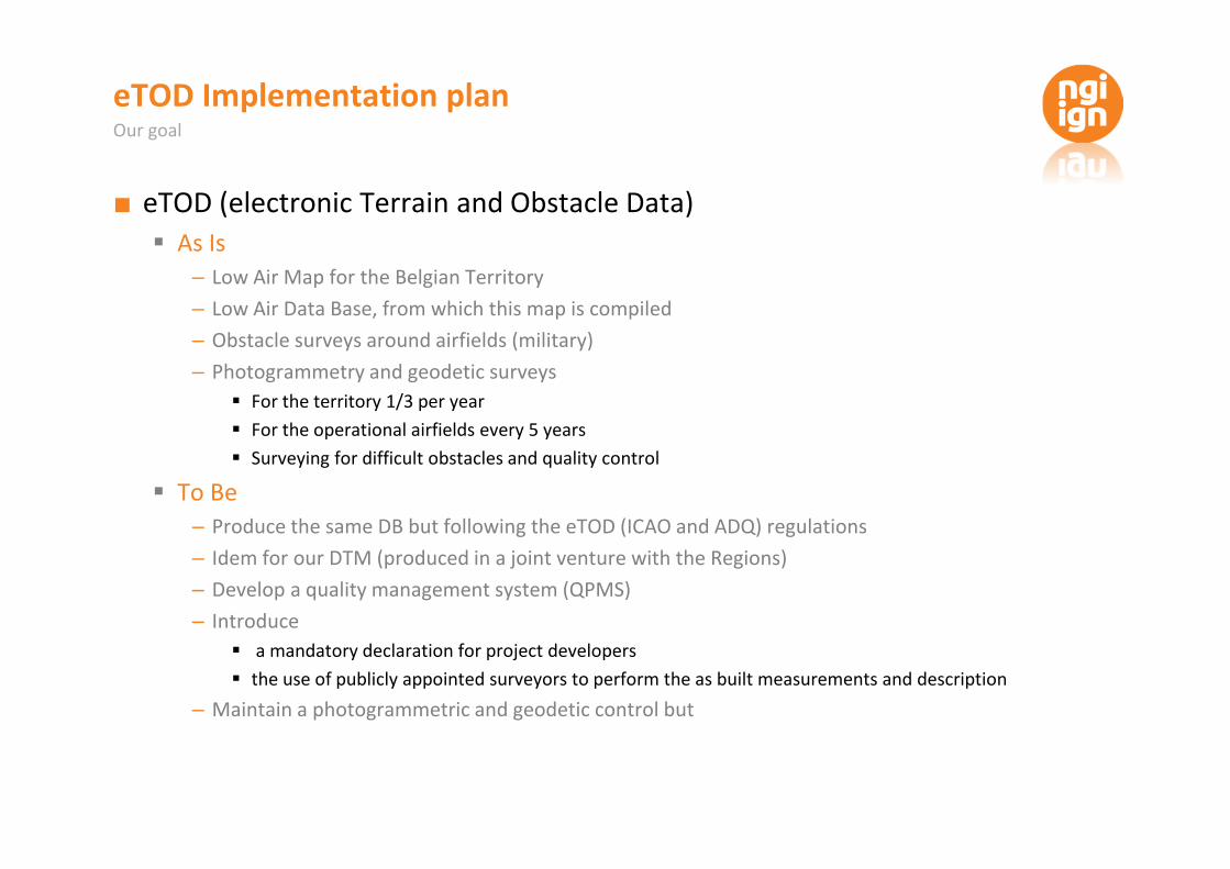
eTOD Implementation plan■ eTOD (electronic Terrain and Obstacle Data)� As Is– Low Air Map for the Belgian Territory– Low Air Data Base, from which this map is compiled– Obstacle surveys around airfields (military)– Photogrammetry and geodetic surveys
� For the territory 1/3 per year� For the operational airfields every 5 years� Surveying for difficult obstacles and quality control
� To Be– Produce the same DB but following the eTOD (ICAO and ADQ) regulations– Idem for our DTM (produced in a joint venture with the Regions)– Develop a quality management system (QPMS)– Introduce� a mandatory declaration for project developers� the use of publicly appointed surveyors to perform the as built measurements and description– Maintain a photogrammetric and geodetic control butOur goal

Planning26 September 2017Jan Feb Mar Apr May Jun Jul Aug Sep Oct Nov Dec2017 Jan Feb Mar2018Phase 1 Phase 5Product specifications v1 Set up QMSPhase 3Mandatory declaration Align production system withETOD/ADQPhase 4Migrate existing dataPhase 2A Upgrade existingdataPhase 2B
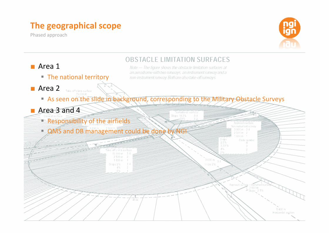
The geographical scope■ Area 1� The national territory■ Area 2� As seen on the slide in background, corresponding to the Military Obstacle Surveys■ Area 3 and 4� Responsibility of the airfields� QMS and DB management could be done by NGIPhased approach

STEP 1: RESPONSIBLE DECLARES NEW OBSTACLE NEW OBSTACLE (1/4)Responsible New Obstacle Obstacleparts Construction siteName * JohnsonSurname* JackAddress * IPostal code * IMunicipality * ICountry* ICompany I XFinishNext >< BackCancel
NEW OBSTACLE (2/4)Type *Name * I AntennaBuilding…WindmillOtherHeight * ICoordinates * IX IYLighting obstacle * Yes No UnknownSynchronised lighting * Yes No UnknownLighting descriptionMarking type * FlagMarkers…MissingUnknownMobile obstacle * Yes No Unknown?Frangible obstacle * Yes No UnknownMaterial * BrickConcrete…WoodUnknownPlanned demolition <1 year1-10 years>10 yearsMarking descriptionResponsible New Obstacle Obstacleparts Construction site XFinishNext >< BackCancel

Obstacle parts * Yes No UnknownNEW OBSTACLE (3/4)Type *Marking type *Mobile obstacle * Yes No UnknownFrangible obstacle * Yes No UnknownMaterial *Part 1 +Add new partMarking descriptionPlanned demolitionResponsible New Obstacle Obstacleparts Construction siteHeight * X
FinishNext >< BackCancelNEW OBSTACLE (4/4)Maximum height *Responsible New Obstacle Obstacleparts Construction siteStart date construction site * dd-mm-yyyyEnd date construction site * dd-mm-yyyyCranes to use with height > 60m* Yes No+Add new craneCrane 1Start date placement crane * dd-mm-yyyyEnd date placement crane * dd-mm-yyyyConstruction permit * Permit.pdf Upload PDF
XFinishNext >< BackCancel
Construction site* New ExistingGraphic selectionSelection by attributeConstruction site ID List constructionsites linked toresponsibleSTEP 1: RESPONSIBLE DECLARES NEW OBSTACLE

STEP 2: RESPONSIBLE DECLARES GEODETIC SURVEYOR Construction sitesDECLARE GEODETIC SURVEYOR (1/2)Geodetic surveyorGeodetic surveyor * autocompletion XFinishNext >< BackCancel Construction sitesDECLARE GEODETIC SURVEYOR (2/2)GEODETIC SURVEYOR XList of linked constructionsites ConstructionSite_1ConstructionSite_2Graphic selectionSelection by attributeConstruction site ID Add tolist List constructionsites linked toresponsibleCancel FinishNext >< Back

STEP 3: GEODETIC SURVEYOR E PROVIDES MEASUREMENT INFO FlagMarkers…MissingUnknownMEASUREMENT INFO FOR OBSTACLE (1/3)Type BuildingName Obstacle XHeight * 103,8Coordinates * X YLighting obstacle * Yes No UnknownSynchronised lighting * Yes No UnknownLighting description * Lighting on top of buildingMarking type * FlagMobile obstacle * Yes No Unknown?Material Concrete BrickConcrete…WoodUnknownMarking description *Obstacle Obstacle parts X
FinishNext >Cancel230918,0 159324,0 Lighting picture * Lighting_1.jpg UploadMarking picture * Marking_1.jpg Upload
Qualitymeasurement< Back
MEASUREMENT INFO FOR OBSTACLE (2/3)Type AntennaMarking type * HBandsMobile obstacle * Yes No UnknownMaterial * MetalObstaclePart_1Marking description * Horizontal bands withwhite and red colouringHeight * 2,5 XFinishNext >< BackCancelMarking colour 1Marking colour 2List of obstacle partsObstaclePart_1ObstaclePart_2Add new partOpenOpen+Marking picture * Marking_1.jpg Upload
Obstacle Obstacle parts QualitymeasurementSave

STEP 3: GEODETIC SURVEYOR E PROVIDES MEASUREMENT INFO MEASUREMENT INFO FOR OBSTACLE (3/3)Vertical accuracy *Horizontal accuracy *Quality measurement Obstacle XHorizontal confidence level *Vertical confidence level * I XList of obstacle partsObstacle XObstaclePart_1ObstaclePart_2 OpenOpenObstacle Obstacle parts QualitymeasurementFinishNext >< BackCancel
OpenSave IIIVertical extent accuracy * I

Conclusions

My Wish List

My Wish List


Conclusions■ European Integration is required� We need a Agency in charge of GI– Work of EuroGeographics is heroic– Size of Belgium is not relevant– History of mapping agencies (ESDP)


Conclusions■ European Integration is required� We need a Agency in charge of GI– Work of EuroGeographics is heroic– Size of Belgium is not relevant– History of mapping agencies■ Blind deregulation is trendy, smart deregulation is better, public appointment best� Europe should stop its deregulation spree– Some professions deserve regulation, and if possible a homogeneous regulation– For some activities, State guarantee implies Civil Servant and Publicly Appointed Surveyors

Reviewing Process

Conclusions■ European Integration is required� We need a Agency in charge of GI– Work of EuroGeographics is heroic– Size of Belgium is not relevant– History of mapping agencies■ Blind deregulation is trendy, smart deregulation is better, public appointment best� Europe should stop its deregulation spree– Some professions deserve regulation, and if possible a homogeneous regulation– For some activities, State guarantee implies Civil Servant and Publicly Appointed Surveyors■ The eTOD implementation should be shared and coordinated in Europe� IGN has an experience in this field and is eager– To share with others to learn and teach– To coordinate to have a common and coherent approach

The strength of Authoritative Data: a Cadaster of Aeronautical Obstacles The possible cooperation of NMCA with Geodetic [email protected]