Cost Analysis of Alternative Culvert Installation ... · PDF fileCost Analysis of Alternative...
85
Take the steps... Transportation Research R e s e a r c h...Kn o w l e d g e ...Innov a t i v e Sol u t i o n s ! 2009-20 Cost Analysis of Alternative Culvert Installation Practices in Minnesota
-
Upload
vuongnguyet -
Category
Documents
-
view
220 -
download
1
Transcript of Cost Analysis of Alternative Culvert Installation ... · PDF fileCost Analysis of Alternative...

Take the steps...
Transportation Research
Research...Knowledge...Innovative Solutions!
2009-20
Cost Analysis of Alternative Culvert InstallationPractices in Minnesota

Technical Report Documentation Page 1. Report No. 2. 3. Recipients Accession No. MN/RC 2009-20 4. Title and Subtitle 5. Report Date
June 2009 6.
Cost Analysis of Alternative Culvert Installation Practices in Minnesota
7. Author(s) 8. Performing Organization Report No. Brad Hansen, John Nieber, and Chris Lenhart
9. Performing Organization Name and Address 10. Project/Task/Work Unit No. 11. Contract (C) or Grant (G) No.
Department of Bioproducts and Biosystems Engineering University of Minnesota Biosystems and Agricultural Engineering Building 1390 Eckles Avenue St. Paul, Minnesota 55108
(c) 89261 (wo) 50
12. Sponsoring Organization Name and Address 13. Type of Report and Period Covered Final Report 14. Sponsoring Agency Code
Minnesota Department of Transportation 395 John Ireland Boulevard Mail Stop 330 St. Paul, Minnesota 55155
15. Supplementary Notes http://www.lrrb.org/PDF/200920.pdf 16. Abstract (Limit: 250 words) Various factors associated with conventional culvert design, including shallow water, perched inlets and high flow velocities, can cause difficulties for migrating fish and affect their genetic diversity and long-term survival. Conventional culvert design has traditionally been based on hydraulic conveyance, safety and cost. Recently, some alternative culvert designs have been developed to facilitate salmon migration on the west coat of the United States. These alternative designs focus on matching the natural dimensions and characteristics of the stream channel through the culvert. The intended purpose of these newer designs is to provide unimpeded passage of aquatic life, reduce maintenance costs and improve erosion control. Currently, some of these new designs are being implemented in Minnesota mostly when fish passage is a consideration. There are concerns about the additional costs associated with these alternative designs as well as whether they are really needed at some road crossings. The objectives of this research were to summarize state-wide fish passage concerns related to culvert road crossings on public waters and to perform a cost comparison between the conventional and the alternative culvert designs.
17. Document Analysis/Descriptors 18. Availability Statement culvert design, economics, fish passage, stream health No restrictions. Document available from:
National Technical Information Services, Springfield, Virginia 22161
19. Security Class (this report) 20. Security Class (this page) 21. No. of Pages 22. Price Unclassified Unclassified 85

Cost Analysis of Alternative Culvert Installation Practices in Minnesota
Final Report
Prepared by
Brad Hansen John Nieber
Chris Lenhart
Department of Bioproducts and Biosystems Engineering University of Minnesota
June 2009
Published by
Minnesota Department of Transportation Research Services Section
Transportation Bldg. 395 John Ireland Boulevard, Mail Stop 330
St. Paul, Minnesota 55155-1899
This report represents the results of research conducted by the authors and does not necessarily represent the views or policies of the Minnesota Department of Transportation and/or the University of Minnesota. This report does not contain a standard or specified technique. The authors and the Minnesota Department of Transportation and/or the University of Minnesota do not endorse products or manufacturers. Trade or manufacturers’ names appear herein solely because they are considered essential to this report.
Acknowledgments
We would like to thank the Technical Advisory Panel for this project for the time commitment in providing guidance to the project investigators. Members of the TAP included: Todd Campbell, (Minnesota Department of Transportation (Mn/DOT), engineer principal), Petra DeWall (Mn/DOT, engineer principal), Alan Forsberg (Blue Earth County, county engineer), David Halbersma (Pipestone County, county engineer), Karl Koller (Minnesota Department of Natural Resources (DNR), Grand Rapids), Shae Komalski (Cook County, county engineer), Peter Leete (DNR, Environmental Services), Susan Miller (Freeborn County, county engineer), Omid Mohseni (Barr Engineering, St. Anthony Falls Laboratory), Frank Pafko (DNR, Environmental Services), Alan Rindels (Mn/DOT, Program Development), Dave Robley (Douglas County, county engineer), Brian Walter (Hancock Concrete Products), and Richard West (Otter Tail County, county engineer). The Technical liaisons for the project were Alan Forsberg and Susan Miller, and the administrative liaison was Alan Rindels. We wish to thank these individuals for their efforts as project liaisons. Special thanks go to Brian Walter for his assistance with the culvert calculations, and to Peter Leete for his help to us in acquiring information about DNR permit requirements.
In addition to the help from the TAP, we acknowledge the assistance from a number of individuals in DNR regional/area offices, and county engineering offices. Their assistance to our project efforts is greatly appreciated.

Table of Contents
Chapter 1: Introduction ............................................................................................................... 1
Chapter 2: Evaluate Fish and Sediment Passage Guidance for Culverts in the Upper Midwest.......................................................................................................................................... 2
General Design Issues for Culverts and Fish Passage .............................................................. 3 Hydraulic and Sediment Conveyance and Water Elevation ............................................ 3 Channel Characteristics (Gradient, Bankfull Width, Bed Material and Velocity) .......... 3 Safety ............................................................................................................................... 4 Prioritization of Importance............................................................................................. 4
Methods of Fish Passage at Road Crossings or Culverts.......................................................... 4 Geomorphic Simulation ................................................................................................... 5 Hydraulic Simulation ....................................................................................................... 6 Hydraulic Design ............................................................................................................. 7
Coastal vs. Midwestern Fish Passage: Application of Lessons Learned from the Coastal U.S. to the Upper Midwest .......................................................................................... 7
West Coast Fish Passage Priorities .................................................................................. 7 East Coast Fish Passage ................................................................................................... 9
Application of Coastal Techniques to the Upper Midwest....................................................... 9 Causes of Fish Passage Blockage at Midwestern Culverts............................................ 12
Fish Passage Projects Conducted in Minnesota and the Upper Midwest ............................... 13 Project Examples ........................................................................................................... 15
Summary Chapter 2 ................................................................................................................ 17
Chapter 3: Determine a Statewide Picture of Fish Passage Concerns Related to Culvert Road Crossings on Public Waters ............................................................................... 19
Conversations with Regional Hydrologists ............................................................................ 19 Review of General Permits ..................................................................................................... 20
Statewide General Permit .............................................................................................. 21 Surveys.................................................................................................................................... 22
County Engineers’ Survey ............................................................................................. 22 DNR and Area Hydrologists Survey.............................................................................. 23
Summary Chapter 3 ................................................................................................................ 24
Chapter 4: Cost Analysis and Comparison of MESBOAC and Other Alternative Culvert Designs ........................................................................................................................... 25
Design Analysis ...................................................................................................................... 26 Slope ....................................................................................................................................... 31 Cost Comparison..................................................................................................................... 31 Conclusions of the MESBOAC Comparison.......................................................................... 33 Other Alternative Culvert Designs.......................................................................................... 34 General Overview ................................................................................................................... 34 Baffles ..................................................................................................................................... 34

Advantages and Disadvantages...................................................................................... 36 Costs............................................................................................................................... 38
Roughened Channels .............................................................................................................. 39 Costs............................................................................................................................... 41
Backwater Weirs..................................................................................................................... 41 Costs............................................................................................................................... 42
Meet Conventional Culvert Design Requirements ................................................................. 44 Summary Chapter 4 ................................................................................................................ 44
Chapter 5: Summary .................................................................................................................. 46
Chapter 6: Questions for Further Consideration .................................................................... 47
References.................................................................................................................................... 48
Appendix A: Definitions Used in Text
Appendix B: Fish Passage Success in East & West Coast and Midwestern Fishes
Appendix C: Endangered, Threatened and Special Concern Fish Species in Minnesota and their Occurrence within Minnesota
Appendix D: County Engineer Survey
Appendix E: DNR and Area Hydrologists Survey
Appendix F: Bridge and Culvert General Permit No. 2004-0001
List of Tables
Table 2.1. Culvert Design Approaches ........................................................................................... 5 Table 2.2. MESBOAC Technique .................................................................................................. 6 Table 2.3. Swimming Speeds of Midwestern Fishes Listed in FishXing Model.......................... 10 Table 2.4. Major River Basins in Minnesota and Fish Passage Issues ......................................... 15 Table 3.1. Statewide Permit Conditions ....................................................................................... 22 Table 4.1. Background Data on Culvert Sites............................................................................... 25 Table 4.2. Bankfull Data............................................................................................................... 28 Table 4.3. Headwater and Stage Increase ..................................................................................... 31 Table 4.4. Cost Comparison.......................................................................................................... 32 Table 4.5. Estimated Installation Costs of Roughened Channels ................................................. 41 Table 4.6. Herra Environmental Consultants Costs for a Log Boulder Weir ............................... 43 Table 4.7. Cost of Installing Two Backwater Weirs..................................................................... 43 Table 4.8. Alternative Design Cost as a Percent of Bankfull Width Culvert Cost ....................... 45 Table B.1. Success of Fish Passage for East Coast Diadromous Fish........................................ B-1 Table B.2. Success of Fish Passage for West Coast Diadromous Fish....................................... B-3 Table B.3. Fish Species of Importance for Fish Passage in Upper Midwest.............................. B-4

List of Figures
Figure 2.1. Perched culverts (photo by US Fish and Wildlife Service)........................................ 13 Figure 2.2. Major basins and watersheds of Minnesota................................................................ 14 Figure 2.3. Location of natural streams and ditches in Minnesota. .............................................. 17 Figure 4.1. Location of culvert installations investigated............................................................. 26 Figure 4.2. Multiple culverts set at same elevation with one culvert filling in with sediment. .... 29 Figure 4.3. (a) Offset; (b) slotted weir; (c) weir baffle; (d) spoiler: (e) Alberta fishweir (AFW); and (f) Alberta fish baffle (Ead et al., 2002). .................................................................. 35 Figure 4.4. Recommended styles of baffles for round and box culverts in Washington (Bates, et al., 2003). ...................................................................................................................... 36 Figure 4.5. Offset baffles retrofit in round concrete culvert. (St. Louis County). ........................ 37 Figure 4.6. Rocks fashioned in as a slotted weir design. (St. Louis County). .............................. 38 Figure 4.7. Roughened channel (St Louis County, MN). ............................................................. 40 Figure 4.8. Roughened channel (St. Louis County, MN). ............................................................ 40 Figure 4.9. Backwater weir design; photo courtesy of Salmon Nation. ....................................... 42

Executive Summary
Minnesota is blessed with an abundance of lakes, rivers and streams. In a state with many water bodies this adds up to thousands of culverts at road crossings. Various factors associated with culverts, including shallow water, turbulence and high-flow velocities, can cause difficulties for migrating fish. Impassable culverts have a negative impact on aquatic life genetic diversity and long-term survival. Surveyed road crossings in the Pine-Popple watershed located in the forested northeast part of Wisconsin showed 67% of the crossings partially or totally blocked fish passage. (Diebel, personal communication). Little is known about the impact these road crossings have on the health of the rivers’ systems and aquatic and native wildlife passage. The design of culverts at these numerous road crossings has traditionally been based on hydraulic conveyance, safety and cost. Currently, an alternative design that focuses on matching the natural stream channel characteristics of slope, width and bed material through the culvert is being used in Minnesota. The purpose of this design is to provide unimpeded passage of aquatic life. Other potential benefits include lower maintenance costs, longer life span and, better sediment and erosion control.
The research associated with this report was originated by a problem statement from county engineers concerned about the necessity, function and additional costs of designing culverts for fish passage. The Department of Bioproducts and Biosytems Engineering at the University of Minnesota received funding from the Local Road Research Board (LRRB) to conduct the research. A technical advisory panel was formed to advise and direct the research problem. Committee members included county engineers, private consultants, Minnesota Department of Natural Resources (DNR) and Minnesota Department of Transportation (Mn/DOT) designers and engineers. The Technical Advisory Panel (TAP) committee modified the original proposal to better fit statewide concerns and fit within a limited budget. The final three main research objectives were to:
1. Evaluate fish and sediment passage guidance for culverts in the Upper Midwest
2. Determine a statewide picture of fish passage concerns related to culvert road crossings on public waters
3. Provide cost analysis of alternative culvert design
Evaluate Fish Passage Concerns in the Upper Midwest
Most of the research done on fish passage has focused on salmon and trout in the Western U.S. The goal of this objective was to see how well this research translated to Minnesota.
The problems creating blockage of fish passage in Minnesota are similar to those on the West Coast: perched outlets, high in-pipe velocity and/or turbulence, inadequate water depth in pipe, excessive pipe length without fish resting space, and debris or sediment accumulation in-pipe. The major differences are fish species, stream geomorphology, and hydrology. The key Upper

Midwestern fish species (walleye, pike, bass, trout, panfish) have different life histories and movement patterns than coastal anadromous fish migrating from the ocean, with movement between lakes and rivers taking on greater importance. Upper Midwestern rivers are different geomorphologically than most West Coast salmon rivers, as they tend to be lower in gradient. Therefore, geomorphic considerations are important for preventing accumulation of fine sediment and fish blockage at low-flow, as well as at high flows. Overall, the tools and techniques used in the coastal U.S. are applicable to the Upper Midwest. The major differences lie in the prioritization of the issues and the types of fish species targeted for management.
Determine a Statewide Picture of Fish Passage Concerns Related to Culvert Road Crossings on Public Waters
The information to fulfill the second objective was summarized from surveys and phone conversations with county engineers and DNR personnel and a review of statewide general and county permits.
A summary of the information collected is listed below:
• Some of the alternative designs currently being used in Minnesota include weirs, roughened channels, baffles, and MESBOAC (Match, Extend, Set, Bury, Offset, Align, Consider). They were usually chosen over a conventional design in response to specific local conditions concerning fish passage, like trout streams in the southeast and steeper gradient streams in northeast.
• Alternative designs were used less than 30% of the time. • The conventional design method of modeling for hydraulic conveyance related to a
specific return period was the most commonly used method of culvert design among county engineers.
• There is not a regional or statewide ranking or prioritization system for fish passage in the state. Prioritizing culvert design for fish passage is done on a case-by-case basis using the knowledge of fish present in the stream.
• Alternative culvert design methods are not well understood outside of the DNR. Collecting the proper data used in the design of alternative methods is usually conducted by DNR personnel and relayed to the county engineering office.
• The function of existing alternative designs has not been evaluated, costs of the designs are not well known, and little response has been heard back from installers on ease of installation.
• Little is known about the effects culverts are having on fish passage, sediment transport, and function. Only a few counties have an inventory or assessment of culverts under 10 feet in diameter.
• A statewide flow requirement is listed in the general permit of “2-year peak flow shall not exceed 2 feet per second”. Only a few county permits address this requirement. The majority do not reference flow velocities at all. Very little evidence of local flow requirements or how they were determined could be found. (Note: The statewide permit has been revised since this survey was conducted.)
Provide Cost Analysis of Alternative Culvert Designs
Cost analysis was performed on four alternative culvert designs. One of the methods, MESBOAC, is a stream-simulation technique designed to mimic the natural channel characteristics through the culvert. The three other designs were baffles, backwater weirs, and roughened channels. These were all used as additions to culverts with the objective to slow water velocities through the channel enough for fish passage.
To conduct an analysis of the cost differential between conventional culvert placement and MESBOAC culvert placement, 15 stream crossing locations in Minnesota were identified. Design plans were acquired for all 15 sites, and a re-engineering of the crossings with the MESBOAC method was conducted for 12 of the sites. The re-engineering was conducted to meet flow capacity, headwater, and stage increase conditions set for the current installations, while also meeting the criteria set for MESBOAC. Differential cost analysis was conducted for 11 of the sites.
All the existing culverts were found to be properly aligned with the stream channel, and they extended sufficiently out from the toe of the roadway embankment. Therefore, these elements did not need to be included in the re-engineering. However, other features did need to be re-engineered, including culvert slope, matching culvert diameter to bankfull channel width, burying culvert bottom into the channel bed, and offsetting of side culverts. More than 50% of the existing culverts were found to have slopes greater than the channel slope. At seven of the 15 sites, the existing culvert width was within two feet of the bankfull channel width. Seven sites had existing culvert width ranging from three to 15 feet greater than the bankfull channel width. At one site, the bankfull width was nine feet greater than the existing culvert width. Culverts that are much greater than or less than the bankfull channel width have the potential to negatively impact fish passage. When multiple culverts were present they were not offset in elevation. Also, existing culverts were not buried into the channel bottom.
The MESBOAC designs were found to match the required flow capacity without significantly increasing either the inlet headwater elevation or stage increase. For some of the sites, the MESBOAC design reduced the headwater stage increase.
For all cases examined, except for one, the MESBOAC design would cost more than the corresponding conventional design. The MESBOAC design added -5 to 33% to the culvert cost. The percent increase in cost was compared to the cost of the culvert structure only and not the entire project cost. Most of the increased cost was associated with a larger culvert needed for the MESBOAC design to accommodate the reduction in flow due to burying the bankfull culvert bottom into the channel bottom. Matching culvert and channel slope plays an important role in affecting flow velocities, but has little effect on increasing the cost of a project. In all cases examined, the MESBOAC designs were fit within two feet of the existing culvert footprint.
Generalized costs were also calculated for baffles, roughened channels, and backwater weirs. Costs were calculated as a percentage of the average bankfull width culvert from 12 work plans analyzed in the MESBOAC analysis. The cost of the culvert structure is generally more than half of the total project cost. Tying the cost of alternative designs to the cost of the culvert as a percentage should allow an estimate of alternative design costs as the scale of the project

increases or decreases. In the case of backwater weirs, the cost per foot of stream width was used as well as bankfull culvert cost. Baffles cost an average of 12.5% of the bankfull culvert cost, roughened channels 10% and backwater weirs 15.1%. The total cost of installation for all three designs ranged from $1,000 to $10,000.

1
Chapter 1: Introduction
Minnesota is blessed with an abundance of lakes, rivers, and streams. In a state with many water bodies, this adds up to thousands of culverts at road crossings. Various factors associated with culverts, including shallow water, turbulence, and high flow velocity, can cause difficulties for migrating fish and affect their genetic diversity and long-term survival. Surveyed road crossings in the Pine-Popple watershed located in the forested northeast part of Wisconsin showed 67% of the crossings partially or totally blocked fish passage (Diebel, personal communication). Little is known about the impact these road crossings have on the health of the river systems and aquatic and native wildlife passage in the Upper Midwest. The design of culverts at these numerous road crossings has traditionally been based on hydraulic conveyance, safety, and cost. Recently, some alternative culvert designs have been developed that focus on matching the natural characteristics of the stream channel, as it passes through the culvert. The purpose of these newer designs is to provide unimpeded passage of aquatic life. Other potential benefits include lower maintenance costs, longer life span, and better sediment and erosion control. Currently, some of these new designs are being implemented in Minnesota, mostly where fish passage is a concern.
The research associated with this report was originated by a problem statement from county engineers concerned about the necessity, function and additional costs of designing culverts for fish passage. The Department of Bioproducts and Biosytems Engineering at the University of Minnesota received a grant to conduct the research. A technical advisory panel was formed to advise and direct the research problem. Committee members included county engineers, private consultants, and personnel from the Minnesota Department of Transportation (Mn/DOT) and the Minnesota Department of Natural Resources (DNR). The TAP committee modified the original proposal to better fit statewide concerns and fit within a limited budget. The final three main research objectives were to:
1. Evaluate fish and sediment passage guidance for culverts in the Upper Midwest
2. Determine a statewide picture of fish passage concerns related to culvert road crossings on public waters
3. Provide cost analysis of alternative culvert design
This research was completed by the University of Minnesota Bioproducts and Biosystems Engineering Department under the authority of Mn/DOT contract ##89261.

2
Chapter 2: Evaluate Fish and Sediment Passage Guidance for
Culverts in the Upper Midwest
Fish passage techniques were originally developed on the West and East Coast of the United States to allow salmonids (salmon and trout species) passage around large dams. It was recognized in the 1800s that dams seriously blocked fish migration (Trautman, 1981). Fish passage in coastal areas of the US focused on anadromous fish, i.e. species that migrate between the ocean and freshwater rivers. More recently (since the 1980s), recognition has increased that many fish species migrate. These includes eels and lampreys, which migrate in reverse from rivers to oceans, and freshwater fish which migrate seasonally for feeding, shelter, and spawning. Fish passage efforts have spread to include all diadromous fish (a broader category of fish migration).
However, until the last decade or so, little notice was given to freshwater fish migration outside coastal areas, even though it was known that freshwater fish migrate seasonally. It was recognized that dams blocked fish, but culverts and road crossings went largely unnoticed. As a result, the blockage of freshwater fish by culverts is very poorly understood in comparison to anadromous fish blockage in coastal regions. However, work in this area has expanded rapidly in the last 5-10 years, particularly for inland areas of the Pacific Northwest.
Road culverts have a variety of impacts on fish habitat and obstruction to movement as described by Bates et al. (2003) in the Washington Fish & Wildlife Department’s guide to fish passage at culverts. Bates et al. describe the following seven major categories of impacts:
1. Direct habitat loss by eliminating areas of channel habitat in the immediate culvert area. Road expansion or installation of new, larger culverts also results in direct loss of stream habitat.
2. Water quality degradation as a result of road crossings creating an entry point for road-runoff pollutants. Some culverts are coated with asphalt to prevent corrosion. In agricultural settings, road culverts are often the entry point for road-side ditches and subsurface tile drainage outlets.
3. Upstream and downstream channel impacts caused by either scour or aggradation and their associated habitat impacts.
4. Ecological connectivity may be reduced by blocking access to upstream or downstream stream segments for fish and other aquatic organisms.
5. Channel maintenance costs may be increased by inducing aggradation at oversized or under-sloped road crossings. Dredging of channel is often required at road crossings and is very damaging to stream habitat.
6. Construction impacts include possible release of sediment or pollutants, temporary barriers to fish passage during construction, removal of streambank vegetation, impeding

3
flow or stranding fish above or below the culvert. Most impacts are short term while excess sediment could persist in streams for months or years.
7. Risk of culvert failure, although infrequent, can cause ecological damage, flooding, and/or road maintenance problems. For public safety concerns must be addressed in all culvert projects.
The Washington State manual describes five ways in which culverts can block fish passage. (Bates et al., 2003):
• Excess drop at the culvert outlet • High velocity within the culvert barrel • Inadequate depth within the culvert barrel • Turbulence within the culvert • Debris and sediment accumulation at the culvert inlet or in the culvert
Another common cause of blockage is excessive length of culvert without sufficient resting area for fish.
Most work has focused on fixing excess velocity and outlet drop issues. However, inadequate water depth and sediment accumulation are frequent problems, especially in low gradient streams commonly found in the Upper Midwest.
General Design Issues for Culverts and Fish Passage
Culvert projects have many common design issues regardless of geographic location. Generally the issues revolve around water and sediment conveyance, geomorphic issues, and flooding. Safety, economics, and prioritization of fish passage are also important components of culvert projects. In general each culvert installation has unique site-specific requirements and characteristics that require addressing the following issues:
Hydraulic and Sediment Conveyance and Water Elevation
The impact of culvert change on wetlands and agricultural fields needs to be examined. For example, changing the size and slope of a culvert may draw down a wetland since the upstream end of the pipe can act as a water level control structure, similar to a dam. Conversely, reducing culvert slope may back water up, creating drainage or flooding issues in agricultural fields.
Along with water conveyance, sediment transport is an issue at culverts. Excess slope and velocity create scour at the mouth, while reduced slope and over sizing lead to aggradation.
Channel Characteristics (Gradient, Bankfull Width, Bed Material and Velocity) How well alternative designs will work is dependent on the unique characteristics of a particular channel. For example, with hydraulic drops of more than several feet, step-pool or other ramp type techniques may be needed.

4
Safety There are several important questions related to public safety and alternative designs.
• How important is safety in the design process? • Does an alternative design have a factor of safety or risk assessment? • How can we be sure the channel width measured to size a culvert is correct? • Do we need to always do some hydraulic assessment of the channel to ensure safety?
Prioritization of Importance Along with technical design issues, prioritization of fish passage importance versus engineering and economic issues is needed. Some of the key questions concerning the importance of passage to fishery resources include:
• What species are present and what are their flow requirements for passage? • What is the quality and quantity of habitat above the culvert? • Are threatened, endangered or special concern species in the watershed? • Is there a minimum size for a culvert where the corresponding watershed area above it is
too small to justify additional costs of an alternative design?
Economics often dictates what is possible for any given project. Project costs and agency budgets need to be considered. Costs and benefits must be weighed to assess the value of maintaining or restoring a viable aquatic community upstream versus the associated additional construction costs.
Methods of Fish Passage at Road Crossings or Culverts
Road crossing design and simulation approaches have been grouped into 5 main categories based on the degree of consideration given to fish passage (Table 2.1). They range from bridges, (which are not discussed here) to conventional culvert design that makes no attempt to address fish passage.
Conventional culvert design is based on hydrologic and hydraulic models that predict peak runoff from a watershed, with the culvert sized accordingly to pass a specified design storm. Fish passage was not addressed in design. More recent culvert design considers sediment transport and fish passage. These recent improvements to hydraulic design practices have reduced the frequency of scour at pipe outlets in many rural areas. While these practices are not focused on specific fish species’ needs, designs that address geomorphologic issues are more likely to provide fish passage to a broad range of fishes. Alternative design and stream simulation techniques take the fish passage issue to another level, addressing issues of low flow, hydraulic variability and sediment transport. Stream simulation models (SSMs) can be broadly grouped into two categories: hydraulic simulation and geomorphic simulation (Frei, 2006) (see Table 2.1 and Appendix A).

5
Table 2.1. Culvert Design Approaches
Simulation models or design approach
Examples, content
Bridges ( No Impedance )
(Not analyzed in this study) Structures that do not restrict flow or impinge upon the channel cross sectional area
Geomorphic simulation
Design approaches that simulate natural channel morphology and sediment transport (e.g. MESBOAC)
(Does not require analysis of fish passage flows).
Hydraulic simulation Design approaches that simulate natural hydraulics of streams by adding rock or natural roughness elements. (Does not require analysis of fish passage flows).
Hydraulic Design for fish passage
Techniques that create water depths and velocities to meet the swimming abilities of target fish populations during specific migration periods. Factors assessed include culvert slope, size, material, and length (Frei, 2006). (example FishXing model)
Conventional Culvert Design
Culverts sized to pass a specified design storm (e.g., 10 years peak flow) with no consideration given to fish passage needs.
For definitions see appendix A
Geomorphic Simulation These approaches are based on restoring or maintaining stream geomorphic parameters and sediment balance within the flow conveyance structure. Geomorphic approaches assume that by matching the channel’s natural conditions, fish passage will be assured. For this reason, detailed analysis of fish passage flows is not carried out. The primary geomorphic approach used in the Midwest is the MESBOAC technique.
MESBOAC (Table 2.2) is based on principles of fluvial geomorphology rather than individual fish swimming ability. It was developed in the northern forested region of Minnesota for the US Forest Service, but is applicable to the Upper Midwest in general.

6
Table 2.2. MESBOAC Technique
1 Match culvert width to bankfull stream width.
2. Extend culvert length through the side slope toe of the road.
3. Set culvert slope the same as stream slope (failure to set culverts on the same
slope as the stream is the primary reason that many culverts impede fish passage).
4. Bury the culvert 4 to 12 inches into the stream bottom. For culverts 2 to 6 feet in
diameter, recess 10 to 18 inches below the stream bottom.
5. Offset multiple culverts.
6. Align the culvert with the stream channel.
7. Consider headcuts and cutoffs.
MESBOAC aims to match the culvert width with natural stream dimensions, while maintaining sediment balance (sediment in = sediment out). In addition to buring the culvert bottom below the streambed, it also provides a low-flow channel that is important for late season migrations which occur from August to November. MESBOAC has the advantage of not requiring analysis of fish passage flows. It assumes that since the natural flow characteristics are maintained fish passage will occur. It also tends to minimize maintenance needs over time by reducing scour and aggradation. It has the disadvantage of requiring larger culverts than conventional hydraulic design. It also requires identification of the bankfull elevation, which takes substantial experience or flow frequency analysis.
Alternative geomorphic simulation methods to MESBOAC have not been widely used in the Upper Midwest. Some of these approaches include the Washington Department of Fish and Wildlife (WDFW) Stream Simulation, the USFWS Stream Simulation (Bates et al., 2006) and the no-slope method. The USFWS method is similar to MESBOAC, with greater focus on sediment transport analysis and without consideration for offset culverts.
Hydraulic Simulation The creation of natural roughness within the culvert to simulate natural hydraulic variation within the channel (pools, riffles, runs, etc.) is an intermediate step between geomorphic simulation and hydraulic design. Hydraulic simulation has not apparently been widely used in the upper Midwest.
7
Hydraulic Design Some hydraulic design with consideration to fish passage flows has been done in the Upper Midwest. This approach considers the flow requirements (maximum velocity, sustained velocity, flow depth, etc) needed by specific species. It has the advantage of allowing for smaller pipe size through appropriate hydraulic analysis and design. The goal is to keep the velocity below a set of thresholds corresponding to a fish’s maximum swim speed, sustained swim speed, and related measures.
Tools such as the FishXing model facilitate hydraulic design and make it more likely to be successful by supplying data on fish swimming speed to design engineers and providing hydraulic design assistance to fisheries managers. FishXing predicts fish passage success given several culvert design parameters that affect velocity and time to swim through a pipe. The data input requirements are culvert dimensions, fish swimming capabilities, tailwater condition, and fish passage flows. FishXing is good for predicting fish passage success for a number of well known Minnesota species. However, there is only swim speed data for 33 of 159 Minnesota fish species. Much of the information about swim speed that exists is based on small amounts of data, often just one study. In addition, some swim speeds are based on an equation calculated by fish size and geometry.
There are two problems associated with the hydraulic design approach. First it focuses only on hydraulics instead of overall migration and behavior patterns of fish and second it is a non-conservative design, meaning that the smallest culvert that meets hydraulic conditions is selected for installation.
The benefit of the hydraulic design approach is that it allows for smaller pipe size, which reduces costs. Hydraulic design does not allow for as much uncertainty and future hydrologic change as the geomorphic simulation approach. If future increases in flow occur from climate change or land-use change, the pipe may have excessive velocity or scour a large drop. Given past changes to hydrology and probable future changes from landuse and/or climate change, the issue of hydrologic uncertainty is increasingly important in culvert design.
Coastal vs. Midwestern Fish Passage: Application of Lessons Learned from the Coastal U.S. to the Upper Midwest
West Coast Fish Passage Priorities The blockage of anadromous fish migration at large dams to upstream spawning grounds has historically been a major focus of fisheries management on West coast rivers like the Columbia, Klamath, and Rogue (Bickford and Skalski, 2000). It became obvious decades ago that salmon fisheries had declined along the Columbia River after construction of the large main stem hydroelectric dams. Efforts to facilitate fish passage on the Columbia River began address the decline of salmon. It has since spread to tributaries and rivers across Oregon, California, Washington and Alaska,
Salmonids have been targeted mostly in West coast fish passage projects, particularly coho, king and sockeye salmon which are members of the genus Oncorhynchus. Pacific salmon may

8
migrate over a 1000 miles from the ocean to spawn in inland gravel stream beds. The other major salomonid group, freshwater trout, which are members of the genus Salvelinus tend to migrate shorter distances than Pacific salmon and so are less frequently targeted for fish passage.
In contrast, other families of fish have been targeted much less than salmon. Sturgeon, eels and lampreys have been considered in some West coast fish passage projects. Of the non-salmonids, sturgeon have been one of the major species of concern, primarily in larger rivers where these rare species are often confined to live.
Numerous fish passage techniques have been used at West coast dams. They fall into one of five main categories: Denil, step-pool, nature-like, lifts, and locks. The Denil ladder uses baffles to reduce velocity in stream reaches with very steep slopes (>10%) Step-pools break large vertical drops into multiple small drops, allowing fish a resting area in the pools. Nature-like channels are bypasses that go around dams in the form of a natural stream. Lifts and locks literally pick fish up and drop them on top of the dam. Denil and step-pool systems are occasionally used at road crossings where large drops have been created by scour holes.
While fish ladders have long been the focus of West coast fish passage, culverts and small road crossings are now being addressed because of their importance to endangered salmon in California, Oregon and Washington. Hanging culverts and/or excessive in-pipe velocity effectively blocked off thousands of square miles of headwaters spawning habitat for coho, chum, king, and chinook salmon and other fishes. The loss of access to habitat has contributed to the decline of salmon and many migratory fish species (Richter et al., 1997). In fact, threatened and endangered species recovery is driving fish passage improvements across streams and rivers of the West coast. Numerous species and genetically distinct populations (sub-species) have become endangered, creating a mandate to improve access to habitat previously blocked off.
The awareness of the fish passage issue has created widespread interest and regulation to improve fish passage at road crossings in the states of Oregon and Washington, in particular. While barely acknowledged just ten years ago, concerns of fish passage at culverts has spread extensively across the Pacific Northwest. Initially focused on getting fish around the large, mainstem dams on the Columbia and other big rivers, fish passage at culverts has spread rapidly because it can be practically accomplished at most road crossings often for relatively little additional cost, with potential great benefits to fish. Small road crossings have historically blocked thousands of square miles of essential fish habitat to migratory fish, particularly in the headwaters and upper reaches of the major western watersheds.
Hydraulic design, designing a culvert so that velocities do not exceed swimming speeds of targeted fish species has been the standard engineering method for designing fish passage at culverts in the western states. However, the preference has shifted in favor of stream simulation methods because they pass a larger variety of fish species, ages classes and size, and require less maintenance over time. Hydraulic design may be used in temporary retrofits of existing culverts that are acting as barriers until a better replacement may be built.
Fishways are not widely used at culverts because they have very precise hydraulic design requirements to function properly and require regular maintenance. Occasionally step-pool systems are designed where large (>3 feet drops) have occurred at culverts. For example, the
9
Adobe Creek project in California, used a step-pool system to allow salmon to move upstream past a greater than six foot drop on the streambed (Lenhart, 2002).
East Coast Fish Passage East coast fish passage has focused on a more diverse group of fish, including American shad, herring, and alewife (the family Clupeidae). Greater fish species diversity exists in eastern rivers than western rivers, and so a wider variety of concerns arise. Shad and herring are important commercial fisheries on the East coast and are still moderately abundant and so have been targeted in many projects in the Mid-Atlantic and New England. Striped bass, eels, Atlantic salmon, sturgeon, white perch, and others have been considered in fish passage projects as well. As with the West coast, fish passage work originally focused on fish ladders at dams on large rivers like the Susquehanna and Connecticut. However, fish passage efforts on smaller streams have exploded in the last five to ten years in New England and the Mid Atlantic.
Non-salmonid passage has been more important on the East coast than the West coast, since Atlantic salmon persist only in parts of Maine and Canada. Along with the shad/herring family, sturgeon passage was addressed in the northeast. For example, sturgeon passage was a high priority on the Connecticut River where fish elevators were used to get them around large dams.
As in the west, step-pool and Denil type ladders have been used at small dams and some road crossings. In the present decade, small dam removal has increased in the northeast and Mid-Atlantic states as an alternative to fish ladders (Lenhart, 2002). While removal is not an option at road crossings, culverts may occasionally be relocated. . Along with the increasing awareness of the fish passage issue, culverts are a growing concern. Efforts have been made along the East coast to pass a wider range of fish species at road crossings. For example, in Maryland fish ladders have been developed that pass tens of different species.
Culvert passage projects have been completed in the northeast for a variety of fish species including shad, alewife, Atlantic salmon, brook trout, brown trout, and other less frequently targeted species such as slimy sculpin, white sucker, and blacknose dace. Many projects have been completed in New Hampshire, Connecticut, Rhode Island, Pennsylvania, New York, and Massachusetts. Frequently these projects were close to the ocean, as they have the greatest and most immediate benefit to migratory fishes.
Application of Coastal Techniques to the Upper Midwest
Much has been learned about fish passage for the salmonid, herring, and sturgeon families in East and West coast projects. The concepts of culvert design to improve fish and aquatic life passage developed in the western U.S. transfer well to Minnesota. Physical hydraulics, engineering, and safety issues are common to all road crossing projects and must be addressed to ensure fish passage. The differences between the coasts and the Midwest lie primarily in the species targeted and different stream hydrology and geomorphology.
The Midwest differs from either of the coasts because most of the major game species are not anadromous, with the exception of the salmon stocked in the Great Lakes. In contrast to the West

10
coast. most rivers in Minnesota and the Upper Midwest have a relatively low gradient,. Therefore, excess velocity is more frequently an issue in West coast streams. In a low gradient environment, aggradation of fine sediment becomes an issue. In these low gradient areas, low-flow blockage is increasingly important requiring geomorphic approaches to keep them free of excess sedimentation.
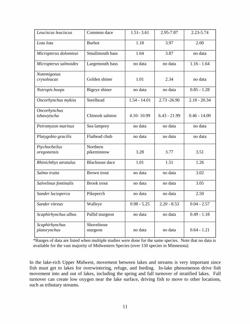
Swimming speeds are known for some Midwestern fish (Table 2.3).. However, there is only swim speed data for 33 of the 159 Minnesota fish species. Much of the information about swim speed that exists is based on small amounts of data, often just one study. In addition, some swim speeds are based on an equation calculated by fish size and geometry.
Table 2.3. Swimming Speeds of Midwestern Fishes Listed in FishXing Model
Scientific Name Common Name Min Swim Speed (ft/s)
Max Swim Speed (ft/s)
Avg Swim Speed (ft/s)
Campostoma anomalum Central stoneroller 0.92 1.76 1.31
Catostomus catostomus Longnose sucker 3.97 7.94 5.96
Catostomus commersoni White sucker no data no data no data
Coregonus artedii Cisco no data no data 1.50 - 2.07
Coregonus clupeaformis Lake whitefish 1.12 - 3.00 2.36 to 4.00 1.8 - 3.50
Cyprinus carpio carpio Common carp 1.50 - 4.00 4.00 - 14.00 2.75 - 9.00
Esox lucius Northern pike 0.62 1.55 no data
Etheostoma blennioides Greenside darter 0.51 1.32 1.02
Etheostoma radiosum Orangebelly darter 0.44 1.50 0.97
Etheostoma whipplei Redfin darter 0.45 1.32 0.92
Gasterosteus aculeatus Three-spined stickleback no data no data 1.19
Gila cypha Humpback chub no data no data 1.31 - 2.30
Lampetra fluviatilis River lamprey no data no data 3.61
Lepomis gibbosus Pumpkinseed no data no data 1.22
Lepomis megalotis Longear sunfish no data no data 0.62 - 1.28
11
Leuciscus leuciscus Common dace 1.51- 3.61 2.95-7.87 2.23-5.74
Lota lota Burbot 1.18 3.97 2.00
Micropterus dolomieui Smallmouth bass 1.64 3.87 no data
Micropterus salmoides Largemouth bass no data no data 1.16 - 1.64
Notemigonus crysoleucas Golden shiner 1.01 2.34 no data
Notropis boops Bigeye shiner no data no data 0.85 - 1.28
Oncorhynchus mykiss Steelhead 1.54 - 14.01 2.73 -26.96 2.18 - 20.34
Oncorhynchus tshawytscha Chinook salmon 4.10- 10.99 6.43 - 21.99 0.46 - 14.00
Petromyzon marinus Sea lamprey no data no data no data
Platygobio gracilis Flathead chub no data no data no data
Ptychocheilus oregonensis
Northern pikeminnow 3.28 3.77 3.51
Rhinichthys atratulus Blacknose dace 1.01 1.51 1.26
Salmo trutta Brown trout no data no data 3.02
Salvelinus fontinalis Brook trout no data no data 3.05
Sander lucioperca Pikeperch no data no data 2.50
Sander vitreus Walleye 0.98 - 5.25 2.20 - 8.53 0.04 - 2.57
Scaphirhynchus albus Pallid sturgeon no data no data 0.49 - 1.18
Scaphirhynchus platorynchus
Shovelnose sturgeon no data no data 0.64 - 1.21
*Ranges of data are listed when multiple studies were done for the same species. Note that no data is available for the vast majority of Midwestern Species (over 150 species in Minnesota)
In the lake-rich Upper Midwest, movement between lakes and streams is very important since fish must get to lakes for overwintering, refuge, and feeding. In-lake phenomenon drive fish movement into and out of lakes, including the spring and fall turnover of stratified lakes. Fall turnover can create low oxygen near the lake surface, driving fish to move to other locations, such as tributary streams.

12
While Minnesota borders on no oceans, several large lakes and rivers act as reservoirs of fish diversity and abundance Lake Superior, Mille Lacs lakes and , the Mississippi, Red, Minnesota, St. Croix, and Rainy Rivers. They are critical areas for fish migration and the maintenance of fish populations. Many fish swim back to major lakes or rivers with deep water for overwintering. If fish access to feeding and overwintering habitat is reduced, then their survival rate, life-span, and health will subsequently be impacted.
State fisheries staff often has knowledge of migratory game species’ movements, such as walleye, pike, smallmouth bass, catfish, and panfish. However, this knowledge is not well documented in published format and is not readily available to road design engineers. This knowledge of fish movements is important, because the timing of migration and needs are different than the well understood coastal salmon runs, affecting the design needs at culverts. For example, walleye do not use fishways very successfully, due to behavioral reasons rather than velocity or hydraulic issues (Peake et al., 2000).
Causes of Fish Passage Blockage at Midwestern Culverts Of the five major causes of fish blockage at culverts (listed on page 3), the most obvious problems occur at “hanging culverts” where a drop of several feet is created by scour at the pipe outlet (Figure 2.1). This may be the result of poor design (undersized pipe or over-steepened slope) or changes to watershed hydrology over time. Hanging culverts are common in urban areas that underwent large increases in peak runoff from urbanization or recent suburban development.
There are also many undersized culverts in agricultural watersheds of south, central, and western Minnesota that have experienced increased runoff or tile flow in recent decades. These higher flows have created downstream scour and excess drop at some culvert locations. The perched culverts illustrated in Figure 2.1 are the classic example of a fish barrier. In the Upper Midwest, fish passage blockage is not always as obvious as in Figure 2.1 but often is more subtle.

13
Figure 2.1. Perched culverts (photo by US Fish and Wildlife Service).
Fish Passage Projects Conducted in Minnesota and the Upper Midwest
The vast majority of culverts found in Minnesota and the Upper Midwest were not designed to address fish passage. As a result, fish barriers may be widespread across the region. Surveyed road crossings in the Pine-Popple watershed located in the forested northeast part of Wisconsin showed 67% of the crossings partially or totally blocked fish passage (Diebel, personal communication). No good inventories of culvert condition related to fish passage exist, making it difficult to define the extent of the problem. Awareness of the issue is fairly low amongst the general public and engineers working on road projects. The upper Midwest does not contain highly visible migratory fishes similar to the Pacific Northwest’s salmon. In Minnesota, Wisconsin, and Michigan, lake fishing is the center of fisheries management activities. People are familiar with lake fisheries such as Leech Lake, Lake Minnetonka, and Mille Lacs and some major river fisheries, like the Mississippi, Rainy and St. Croix Rivers. However, in distant tributaries, fisheries benefits are not as obvious. Yet connections between major rivers, lakes and tributaries are important to many Midwestern fish species including walleye, pike, bass, and the non-native Great Lakes salmon (Figure 2.2 and Table 2.4).

14
Figure 2.2. Major basins and watersheds of Minnesota. Midwestern fish ranges and populations have been greatly reduced by blockage at dams and road crossings. Trautman (1981) described in detail the shrinking of the range for migratory freshwater fishes in Ohio between 1850-1980, as a result of migration barriers and habitat degradation. Some of the migratory fishes that used to range across much of the Upper Midwest include walleye, sturgeon, paddlefish, skipjack herring, cisco, bass, and others, no longer exist in much of their historic range. Habitat destruction or degradation of course went hand-in-hand with the shrinking ranges, making it difficult to differentiate the causes of population declines. In Minnesota, there are 21 fish species listed as endangered, threatened, or special concern species. At least 8 of these are known to migrate substantial distances: northern and southern brook lampreys, lake sturgeon, blue sucker, skipjack herring, cisco, and yellow bass (Appendix C).

15
Table 2.4. Major River Basins in Minnesota and Fish Passage Issues
Name Key fish Geomorphology Other issues
Great Lakes Chinook salmon, lake trout …
High gradient, cobble beds Fall spawning
Upper Mississippi
Walleye, bass, pike Mod gradient, sand-gravel bed
Minnesota River
Catfish, smallmouth bass …
Low gradient, sand/fines bed
St. Croix River Smallmouth bass, sturgeon …
Moderate gradient
Lower Mississippi
Brook & brown trout, smallmouth bass
High gradient tribs,
low gradient in Mississippi
Brook & brown trout spawn in fall; highest fish diversity of all basins
Red River Sturgeon, pike Low gradient agriculture
Rainy River Lake trout, smallmouth bass, walleye
Moderate gradient, gravel bed
BWCA wilderness, forestry
Missouri River Topeka Shiner Prairie streams Endangered species
Project Examples
Hydraulic design has been used in a few Minnesota projects, according to a survey of Minnesota county engineers (see Appendix D). Fish passage on Lake Superior tributaries has been important to fisheries managers because of migrating steelhead a popular non-native game species fish that run up tributaries to spawn). However, statewide, alternative fish passage design at culverts is used in less than 30% of new installations in Minnesota.
The primary alternative culvert design used in Minnesota is MESBOAC, a form of geomorphic simulation developed by the US FS. In recent years, the MESBOAC technique has increased in popularity and was applied in numerous settings, particularly on USFS roads in central-northern Minnesota. MESBOAC is also considered to be the method of choice by the Michigan Department of Environmental Quality (DEQ). Other stream simulation techniques have not been widely used in Minnesota.

16
Fish ramps have also been used at dams in western Minnesota and other places where large drops occur. Rock ramps were used at some dam removal sites in the Otter Tail and Red River basins. These were step-pool type systems designed to keep hydraulic drop to a minimum, enabling fish such as sturgeon to access upstream habitat. These projects were part of a larger effort by the MN DNR to restore lake sturgeon to its historic range in the Red River of the North basin.
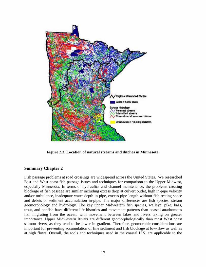
In cases where rough fish or lampreys have a negative impact, fish passage is often intentionally blocked by dams or weirs. Carp uproot aquatic vegetation in shallow lakes and marshes, eliminating food sources for waterfowl and degrading water quality. In south central Minnesota, a project was recently funded to repair dams in wildlife areas to exclude carp from shallow lakes or emergent marshes. Much of the southern and western portion of the state did not have a naturally dense network of streams and so fish connectivity was naturally limited. This region is now heavily ditched, creating connectivity with areas that weren’t historically connected. Ditches are shown in Figure 2.3.
On the Lake Superior shore of the Upper Peninsula of Michigan, non-native sea lampreys have been blocked from spawning in the Great lakes tributaries. Sea lampreys were partly responsible for the decline of Great Lakes Lake Trout and Whitefish by parasitism.
17
Figure 2.3. Location of natural streams and ditches in Minnesota. Summary Chapter 2
Fish passage problems at road crossings are widespread across the United States. We researched East and West coast fish passage issues and techniques for comparison to the Upper Midwest, especially Minnesota. In terms of hydraulics and channel maintenance, the problems creating blockage of fish passage are similar including excess drop at culvert outlet, high in-pipe velocity and/or turbulence, inadequate water depth in pipe, excess pipe length without fish resting space and debris or sediment accumulation in-pipe. The major differences are fish species, stream geomorphology and hydrology. The key upper Midwestern fish species, walleye, pike, bass, trout, and panfish have different life histories and movement patterns than coastal anadromous fish migrating from the ocean, with movement between lakes and rivers taking on greater importance. Upper Midwestern Rivers are different geomorphologically than most West coast salmon rivers, as they tend to be lower in gradient. Therefore, geomorphic considerations are important for preventing accumulation of fine sediment and fish blockage at low-flow as well as at high flows. Overall, the tools and techniques used in the coastal U.S. are applicable to the

18
Upper Midwest. The major differences lie in the prioritization of the issues and the types of fish species targeted for management.

19
Chapter 3: Determine a Statewide Picture of Fish Passage Concerns Related
to Culvert Road Crossings on Public Waters
The three steps listed below outline the actions taken to determine a statewide view of fish passage at road crossings.
• Conversations with area and regional hydrologists provided information from a regional prospective.
• A review of statewide general and county permits provided background information about current state requirements for culvert installations.
• Online and mailed surveys to county engineers and DNR personnel.
Conversations with Regional Hydrologists
All DNR regional hydrologists were contacted by phone to get their general impression of current culvert design and installation in Minnesota. It was clear from the conversations that some aspects of different alternative designs are being implemented in different areas of the state. The type of alternative design used is usually in response to specific local conditions. Two examples of specific local conditions in Minnesota are, trout streams in the southeast, and steeper gradient streams in the northeast. Alternative design methods are being met with some resistance by local governments because of economics. The exception is in the southeast region where local communities recognize the value of trout streams to local economies.
Comments from the conversations are summarized in the following subsections.
Region 1 covers west and northwestern Minnesota. The regional hydrologist was unavailable for discussion. Instead we talked to an area hydrologist whose responsibility covers three counties. He was not too familiar with alternative designs and basically stays within the general permit requirements.
Region 2 covers northern and northeastern Minnesota. During the last ten years there has been implementation of some aspects of alternative design. These aspects include low-flow channels with multiple culverts, V-notch weirs, culvert alignment. Pre-issued permits for Carlton, Itasca and St. Louis counties specify that the MESBOAC approach should be used by local government units.
Region 3 covers central and southeastern Minnesota. Standard requirements for culvert installations and velocity are used in the region with the exception of the southeast, where alternative designs are being used. There is good cooperation in the southeast because of the economic and recreational benefits of trout streams.
Region 4 covers south and southwestern Minnesota. The trend is toward removal of bridges and replacement with culverts. This places a greater impact on the corridor movement of different species as culverts impede movement more than bridges. Greater concern in southern Minnesota is that streams and ditches are some of the last travel corridors available to wildlife and fish.

20
Review of General Permits
In the following we describe some background information on general permits from the 2000 Mn/DOT Drainage Manual.
General permits are “pre-issued” permits issued on a statewide or county level. If work proposed in public waters or public waters wetlands meets the requirements of a specific general permit, an individual permit is not required. Currently there are five categories of general permits as follows:
• Emergency Repair of Public Flood Damages • Multiple Purposes • Bridge and Culvert Projects • Dry Hydrants • Bank/Shore Protection or Restoration
An individual permit is required if the proposed work does not meet the requirements of a specific general permit.
To construct a bridge or culvert, or to fill or excavate the bed of a public watercourse having a total drainage area, at its mouth, of less than 5 square miles (3,200 Acres) - A DNR Public Waters Work Permit is not required, provided:
1. County zoning officials and local Soil and Water Conservation District are given at least seven days prior notice to determine that the project will not result in downstream erosion or sedimentation;
2. The project will not divert water to a different watershed;
3. The project will not impound water by damming the watercourse; and
4. The watercourse is not an officially designated trout stream.
The following information pertaining to culvert size and velocities is from the 2000 Mn/DOT Drainage Manual.
The 50-year frequency storm event is used as the criteria for the design of minor culverts 48” or less in diameter. It is not required to compute an over-topping flood. A larger design frequency may be required if there is a significant flood damage potential upstream, there are special traffic considerations, or to accommodate FEMA mapped floodplains. A risk assessment shall be completed for all major culverts 54” or larger. The 500-year flood or over-topping flood (of less than Q500) shall be computed.
The maximum velocity at the culvert exit shall be consistent with the velocity in the natural channel or shall be mitigated with: channel stabilization or energy dissipation. In general, outlet velocities less than 6 feet per second will not require energy dissipaters or protection. The culvert should be designed to maintain a minimum velocity capable of keeping sediment and debris from clogging the culvert function. Use should be made of a maximum outlet velocity of 2.5 feet per second for the mean annual flood (2-year frequency) when streambed material size is unknown.

21
The last paragraph is in line with DNR requirements listed in the general permit (November 2008) of “Two year peak flow velocities of no greater than 2 feet per second”.
Statewide General Permit The current statewide general permit was signed in late November 2008. The purpose of this general permit is to streamline the permitting process by combining early DNR environmental review and DNR regulatory review. This provides Mn/DOT with early guidance on the requirements for protecting the physical and biological characteristics of a waterway.
An analysis of the statewide and county permits was performed to help answer the questions about standard flow velocities and potential differences between regions. Listed below are the conclusions from the general permits analysis:
• The statewide permit addresses 24 conditions related to replacement or repair of bridges and culverts in Minnesota’s public waterways (Table 3.1) (See Appendix F for a complete description of each condition)
• The previous general permit referenced a flow requirement of “Two year peak flow velocities of no greater than 2 feet per second” under the fish passage condition. The current wording addressing fish passage is “When possible a single culvert or bridge shall span the bankfull width adequate for natural debris and sediment transport rates to closely resemble those of upstream and downstream conditions.” The rest of the wording under the fish passage condition closely matches the seven elements of the MESBOAC method discussed in this report.
• Within each region individual permits are written for each county to address specific conditions unique to the area.
• If new county permits have been written based on the new general permit they were not reviewed for this report. A review of the county permits based off the old permit showed only region three counties referencing fish passage requirements.
• The regional hydrologist from Region 2 wrote three permits one for each county of Itasca, Crow Wing and St. Louis counties that referenced using the MESBOAC approach for sizing and designing culverts (January 2, 2007).

22
Table 3.1. Statewide Permit Conditions
1. Notification and project authorization 13. Flowline/Gradient not changed
2. Application projects 14. Hydrologic/hydraulic reporting
3. Environmental review 15. Flood stage damage not increased
4. Maintenance projects 16. Water level control
5. Wetlands notification above OHW 17. Materials handling
6. Photos as built 18. State trails
7. Invasive Species 19. Erosion and sediment control
8. Species prohibition 20. Fish spawning and movement
9. Preliminary engineering 21. Fish passage
10. Demolition and construction 22. Species movement
11. Navigation maintained or improved 23. Nesting birds
12. Dewatering 24. Native plants/biodiversity significance
Surveys
Two different surveys were produced to help assess the current activities and experiences related to culvert installation in Minnesota. One was targeted at county engineers to get an idea on current culvert design. The second survey targeted area hydrologists and DNR personnel. This survey was 2used to gather information on water and fish passage requirements related to culvert design. The results of the two surveys are presented below.
County Engineers’ Survey On January. 17, 2008 the survey was distributed to county engineers attending a state conference. Thirty surveys were received back. The survey questions, along with a summary of responses to the questions, are presented in Appendix D.
The following is a synopsis of the information obtained from the surveys:
• Only a few counties have an inventory or assessment of culverts under 10 feet in diameter.

23
• The most commonly used method for culvert design is some form of hydraulic conveyance based on watershed area and return period. Most of the designs for small culverts are done by the county, while designs for larger culverts are usually sent out to a consulting firm (probably) because a risk assessment is required for any culvert over 54” in diameter.
• About 50% of the respondents were familiar with some aspects of alternative culvert design.
• Most counties received or have received some input on culvert design from the DNR. About 50% of the respondents were aware that alternative approaches for culvert design do exist, and there is a fair amount of interaction with the DNR on culvert design. However, only a small fraction of the actual designs most commonly used are alternative designs.
DNR and Area Hydrologists Survey This survey was sent out to 30 DNR division offices, 26 area hydrologists and four regional hydrologists. A total of 28 responses were returned. The survey questions and the summary responses are presented in Appendix E. The following is a synopsis of the response.
• Fish passage ranked as the most important criteria for culvert design, followed by controlling wetland water elevations, flood capacity, and matching existing channel characteristics all tied for second. Future maintenance costs, controlling water level elevations on agricultural lands, and total installation cost ranked fifth through seventh respectively.
• Most of the respondents were familiar with alternative designs, but experience with implementation of alternative designs was less than 30%. Of the alternative designs being implemented, the majority were put in place because of fish passage concerns.
• The function of existing alternative designs has not been evaluated, costs of their designs are not well known, and little response has been heard back from installers on ease of installation.
• Local governments have somewhat accepted alternative designs.
• The uses of the general permits “Two year peak flow shall not exceed 2 feet per second” recommendation is not widely used and there is little understanding of how local flow requirements are determined.
The current general permit was not in place at the time the surveys were conducted so no input on the new wording under the fish passage condition is included in this report.

24
Summary Chapter 3
The importance of fish passage at culverts is addressed by the DNR usually only when the culvert needs to be replaced most commonly due to road construction. on public waters a permit is required from DNR before the county or state can proceed with the construction. The culvert design is influenced by the importance of fish passage and is usually worked out between agencies to make sure both fish and adequate flows can pass. The process usually occurs on a case by case basis. There is not a regional or statewide ranking or prioritization system for fish passage in the state that can be used to identify high priority road crossings that require more analysis and design.
Some aspects of different alternative designs are being implemented in different areas of the state, usually in response to specific local conditions concerning fish passage; such as trout streams in southeast and steeper gradient streams in northeast. Some of the different techniques being used are low flow channels with multiple culverts, V-notch weirs and backwater weirs, culvert alignment, rock baffles inside culverts, and MESBOAC. Most of the design expertise for fish passage culverts is with the DNR. As a result, the data collection and type of design chosen falls on DNR personnel. The function of these alternative designs has not yet been evaluated.
DNR and DNR area-hydrologists ranked fish passage concerns as the most important criteria for culvert design, followed by controlling wetland water elevations, flood capacity and matching existing channel characteristics tying for second. Future maintenance costs, controlling water level elevations on agricultural lands and total installation cost ranked fifth through seventh respectively.
The previous general permit referenced a flow requirement of “Two year peak flow velocities of no greater than 2 feet per second” under the fish passage condition. The current general permit wording is “When possible a single culvert or bridge shall span the bankfull width adequate for natural debris and sediment transport rates to closely resemble those of upstream and downstream conditions.” The rest of the wording under the fish passage condition closely matches the seven elements of MESBOAC.
25
Chapter 4: Cost Analysis and Comparison of MESBOAC and Other Alternative Culvert Designs
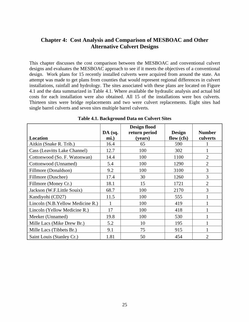
This chapter discusses the cost comparison between the MESBOAC and conventional culvert designs and evaluates the MESBOAC approach to see if it meets the objectives of a conventional design. Work plans for 15 recently installed culverts were acquired from around the state. An attempt was made to get plans from counties that would represent regional differences in culvert installations, rainfall and hydrology. The sites associated with these plans are located on Figure 4.1 and the data summarized in Table 4.1. Where available the hydraulic analysis and actual bid costs for each installation were also obtained. All 15 of the installations were box culverts. Thirteen sites were bridge replacements and two were culvert replacements. Eight sites had single barrel culverts and seven sites multiple barrel culverts.
Table 4.1. Background Data on Culvert Sites
Location DA (sq.
mi.)
Design flood return period
(years) Design
flow (cfs) Number culverts
Aitkin (Snake R. Trib.) 16.4 65 590 1 Cass (Leavitts Lake Channel) 12.7 100 302 1 Cottonwood (So. F. Watonwan) 14.4 100 1100 2 Cottonwood (Unnamed) 5.4 100 1290 2 Fillmore (Donaldson) 9.2 100 3100 3 Fillmore (Duschee) 17.4 30 1260 3 Fillmore (Money Cr.) 18.1 15 1721 2 Jackson (W.F.Little Souix) 68.7 100 2170 3 Kandiyohi (CD27) 11.5 100 555 1 Lincoln (N.B.Yellow Medicine R.) 1 100 419 1 Lincoln (Yellow Medicine R.) 17 100 418 1 Meeker (Unnamed) 19.8 100 530 1 Mille Lacs (Mike Drew Br.) 5.2 10 195 1 Mille Lacs (Tibbets Br.) 9.1 75 915 1 Saint Louis (Stanley Cr.) 1.81 50 454 2

26
Figure 4.1. Location of culvert installations investigated. http://geology.com/state-map/minnesota.shtml
The 15 work plans were re-engineered using the design elements of MESBOAC. Re-engineering involved replacing the conventional in-place culvert design with the MESBOAC design while maintaining conventional design objectives. The re-engineering was conducted to meet flow capacity, headwater, and stage increase conditions set for the current installations, while also meeting the criteria set for MESBOAC. Differences in cost between the conventional culvert design and MESBOAC approach were determined for 11 of the 15 sites.
Design Analysis
None of the 15 culvert installations examined had to be modified to match three of the elements of MESBOAC, Extend, Align and Consider head cuts. The following parameters all had an effect on design and potential costs and were considered in re-engineering the work plans:

27
• Stay within footprint of current design • Use standard culvert sizes • Match buried culvert width to channel bankfull width • Top elevations of multiple culverts should match • Bury bankfull width culvert one foot below channel bed • Place offset culverts two feet above bankfull culvert invert • Match design headwater elevation • Minimize or reduce stage increase
Stay within footprint of current design. The re-engineered designs were fit into place without raising the road bed elevation or changing the in-place culvert length. Change in overall culvert width was kept under two feet. This was done to insure the original design requirements of the culvert were met.
Use standard culvert sizes. Standard culvert sizes were used to minimize the additional cost of special order culverts. Whenever a decision had to be made to move up or down in culvert width to match a standard size, the larger size was chosen to allow for possible increased flows in the future.
Bury bankfull width culvert one foot below channel bed. One of the key elements of a MESBOAC design is to have bed material in the culvert closely match that of the natural channel. All re-engineered designs had a single or double culvert, closely matching bankfull width, buried one foot below the flowline of the stream bed. The flowline elevation used was taken directly from the work plan. This will allow stream sediments to fill in the culvert bottom or other bed material set in-place. How deep a culvert should be buried can be influenced by culvert size, flood capacity and bed material size. One foot below the channel bed elevation was chosen for all sites to simplify the cost comparison. Burying a culvert one-foot below grade can reduce the capacity of the culvert. This results in choosing a larger more expensive culvert for a MESBOAC versus a conventional design.
Match top elevation of culverts. When multiple culverts were needed they were sized to match the top elevation. thus minimizing difficulties in grading and tying culverts together.
Match buried culvert width to channel bankfull width. Buried culvert width was selected to match or slightly exceed the channel bankfull width. The widest standard size culvert is 16 feet. For streams with bankfull width greater than 16 feet multiple culverts were used to match the bankfull width. Bankfull width is a critical dimension of MESBOAC... Determining proper bankfull width can take some onsite detective work. This report used a combination of onsite measurements, cross-sections from the culvert work plans, and regional curves developed for Minnesota to determine bankfull width (Magner, personal communication, 2008). Table 4.2 contains the bankfull data for each of the study sites.

28
Table 4.2. Bankfull Data
Location
DA (sq. mi.)
Number of
existingculverts
Total existing culvert width
all barrels
(ft)
Bankfull channel
width (ft)
Re-engineeredMESBOAC
bankfull culvert
width (ft)Aitkin (Snake R. Trib.) 16.4 1 16 14 16 Cass (Leavitts Lake Channel) 12.7 1 14 23 14 Cottonwood (So. F. Watonwan) 14.4 2 28 13 14 Cottonwood (Unnamed) 5.4 2 22 8 12 Fillmore (Donaldson) 9.2 3 36 17 16 Fillmore (Duschee) 17.4 3 36 22 24 Fillmore (Money Cr.) 18.1 2 24 21 24 Jackson (W.F.Little Souix) 68.7 3 30 28 24 Kandiyohi (CD27) 11.5 1 10 12 12 Lincoln (N.B.Yellow Medicine R.) 1 1 8 4 8 Lincoln (Yellow Medicine R.) 17 1 10 12 12 Meeker (Unnamed) 19.8 1 10 12 12 Mille Lacs (Mike Drew Br.) 5.2 1 14 11 14 Mille Lacs (Tibbets Br.) 9.1 1 10 9 10 Saint Louis (Stanley Cr.) 1.81 2 20 10 10
Four sites located in Lincoln, Meeker, Kandiyoh, and Cass counties had bankfull channel widths greater than the existing culvert width. Because the flow gets funneled into a smaller area, the culvert velocity will be greater than channel velocity at bankfull flow. This increase in velocity could prohibit fish passage, and could cause erosion of sediment inside the culvert. The Cass county site had restrictions that did not allow the installation of a culvert that would match the bankfull width. A simulated roughened channel consisting of eight large boulders placed in the culvert helped reduce the velocities and provide resting locations for fish. At six of the 15 sites the existing culvert width was within two feet of the bankfull channel width. Eight sites had existing culvert widths more than two feet greater than the bankfull channel width. None of these sites had offset culverts. This situation can lead toward sedimentation or flow depths too shallow for fish passage. The far right column shows the MESBOAC bankfull culvert width chosen for comparison to the bankfull channel width. It does not include the width of additional offset culvert barrels.
Offset culverts placed two feet above bankfull culvert invert. Seven sites had multiple culverts in the original design. Offsetting multiple culverts at higher elevations keeps the main bankfull culvert or culverts at the proper width to maintain natural channel characteristics while allowing

29
a larger design flow to pass without overtopping the road. It also reduces the chances of sediment collecting in the offset barrels as shown to be a problem for the culvert illustrated in Figure 4.2. The re- engineered plans set any multiple culverts outside of the bankfull width at an elevation two feet higher than the bankfull culvert invert or one foot above the streamline elevation.
Figure 4.2. Multiple culverts set at same elevation with one culvert filling in with sediment.
Match design headwater elevation. Head water elevation is the water elevation at the head of the culvert at design flow. Matching the original work plan headwater elevation was one of the criteria used to insure the MESBOAC design could adequately pass the design flow of the original work plan (Table 4.3). The HY8 software a culvert analysis program produced by the Federal Highway Administration (FHA) was used to do the analysis (FHA, 2008). In Table 4.3 the plan headwater elevations came directly from the hydrologic and hydraulic analysis done for the culvert replacement. The in-place headwater elevations were generated by HY8 from the work plan culvert data. The two values matched closely enough (+/- 0.35 feet) to give us confidence that our interpretation of the work plan matched those of the original designer. For the MESBOAC design culvert sizing was done to match the eight criteria listed above and the
30
headwater elevation of the in-place culvert. The MESBOAC and in-place headwater elevations matched within (+/- 0.3 feet.)
Minimize or reduce stage increase. For this report stage increase is defined as the difference between the headwater and tailwater elevation. Section 13 of the statewide general permit (Mn/DOT, 2008) states that for new crossings or for replacement of existing crossings that have a stage increase of 0.5 feet or less shall have no greater stage increase than 0.5 feet. Replacement structures of existing crossings that have greater than 0.5 feet increase in stage can match the existing structures stage increase if it does not impact upstream flooding. All of the work plans examined were replacement structures with existing stage increases of 0.5 feet or greater. Culverts were sized to match the existing structures stage increase. Table 4.3 lists the in-place and MESBOAC design stage increases. The MESBOAC designs increased the stage increase over the existing structure stage increase for three sites, but none greater than 0.16 feet. All the other sites showed a reduction in stage increase.

31
Table 4.3. Headwater and Stage Increase
Location Headwater elevation (feet)
In-place stage
increase (feet)
MESBOAC stage
increase (feet)
In-place -MESBOAC
stage increase
(feet) Plan In-place MESBOAC Aitkin (Snake R. Trib.) 1242.8 1242.76 1242.54 1.4 1.18 -0.22 Cass (Leavitts Lake Channel) Cottonwood S. F. Watonwan 1321.2 1321.09 1320.87 1 0.78 -0.22 Cottonwood (Unnamed) 1242.8 1242.33 1242.41 1.8 1.88 0.08 Fillmore (Donaldson Cr.) 1082.7 1082.63 1082.79 2.8 2.96 0.16 Fillmore (Duschee) 497.7 498.09 497.97 1 0.88 -0.12 Fillmore (Money Cr.) 991 990.37 990.18 2.8 2.61 -0.19 Jackson (Little Sioux) 1459.8 1459.79 1459.9 1.6 1.7 0.1 Kandiyohi (CD27) 1229.6 1229.43 1229 2.4 1.97 -0.43 Lincoln (Unnamed trib.) Lincoln (Yellow Medicine) Meeker (Unnamed) 984.9 984.79 984.1 1.9 1.21 -0.69 Mille Lacs (Mike Drew) 1104.6 1104.36 1104.05 3.2 2.89 -0.31 Mille Lacs (Tibbets Brook) 1193.2 1193.87 1193.9 0.5 0.53 0.03 St. Louis (Stanley Creek) 1145.8 1145.69 1145.69 0.75 0.75 0
Slope
Slope also plays a significant role in controlling velocities through culvert structures. Nine culverts had slopes greater than the channel slope. Depending on the tailwater conditions culvert slopes greater than the channels slopes could produce velocities that would inhibit fish passage. The tailwater conditions of the re-engineered work plans were unknown. Calculations of difference in velocities between the channel and inside the culvert were not calculated.
Cost Comparison
Table 4.4 outlines the cost differences for 11 of the 15 original work plans. The Cass County site was more of a lake channel than a stream, the two sites in Lincoln County had incomplete data and the Stanley Creek site in St. Louis County is already a MESBOAC design. The additional cost of installing a MESBOAC design basically came down to culvert sizing and some additional excavation or fill. As mentioned before, the culvert alignment and culvert extension (beyond toe slope) did not have to be modified. Additional costs for offsetting multiple culverts, changing slope and burying the bankfull width culvert is either excavation or additional bed aggregate. At

32
an average price of $3.00/yd for excavation and $15.00/yd for additional aggregate the additional costs to the total project are minimal. Additional excavation and aggregate costs ranged from $100 to $1,850 for the 11 sites
Culvert sizing came down to matching bankfull width and maintaining adequate capacity. When a bankfull culvert is buried one foot an increased culvert height of one foot is needed to maintain the same capacity. The costs listed in Table 4.4 do not reflect the entire cost of a culvert replacement. They include the cost for the culvert(s) itself without consideration for any additional cuts or fill materials. The cost differential ranged from -5 to 33%. This is not a increase of the total project cost. It is a percent increase in the cost of the culvert structure. County engineers we talked to estimate the cost of the culvert structure generally is about 50-70% of the total project cost. The average percent increase of the MESBOAC design culverts over the in-place culverts was 10 %. The highest cost difference was 33 % for the Meeker County site. It required a larger culvert both in width and height as the in-place structure was undersized for bankfull width. The Jackson County site showed a reduction in cost for the MESBOAC design as two 14’ by 10’ culverts were used to replace three 10’ by 9’ culverts. The cost reduction was mainly due to requiring only four culvert end sections instead of six.
Table 4.4. Cost Comparison
Culvert cost (dollars) Difference Difference as percent
Location In-place MESBOAC Aitkin (Snake R. Trib.) 32512.2 35429 2916.8 9 Cass (Leavitts Lake Channel) Cottonwood (So. F. Watonwan) 71795 74754 2959 4 Cottonwood (Unnamed) 73043.6 77423 4379.4 6 Fillmore (Donaldson Cr.) 167095.6 188604 21508.4 13 Fillmore (Duschee) 121885.4 123323.2 1437.8 1 Fillmore (Money Cr.) 83188 88942.4 5754.4 7 Jackson (Little Sioux) 81811.8 77894 -3917.8 5 Kandiyohi (CD27) 62914.6 78828.4 15913.8 25 Lincoln (Unnamed trib.) Lincoln (Yellow Medicine) Meeker (Unnamed) 29197 38920.4 9723.4 33 Mille Lacs (Mike Drew) 39041.8 42084.6 3042.8 8 Mille Lacs (Tibbets Brook) 20178.2 22370 2191.8 11 St. Louis (Stanley Creek)

33
Conclusions of the MESBOAC Comparison
To conduct an analysis of cost differential between conventional culvert placement and MESBOAC culvert placement 15 stream crossing locations in Minnesota were identified. All sites had existing culverts for the crossing. Thirteen of the sites had been bridge crossings prior to the use of culverts for the crossings, while two of the sites had been culvert crossings prior to the current culvert placements. Design plans were acquired for all 15 sites, and a re-engineering of the crossings with the MESBOAC method was conducted for 12 of the sites. The re-engineering was conducted to meet flow capacity, headwater, and stage increase conditions set for the current installations, while also meeting the criteria set for MESBOAC. Differential cost analysis was conducted for 11 of the sites.
All the existing culverts were found to be properly aligned with the stream channel, and they extended sufficiently out from the toe of the roadway embankment. Therefore, these features did not need to be included in the re-engineering. However, other features did need to be re-engineered including culvert slope, matching the culvert to bankfull channel width, burying of the culvert into the channel bed, and offsetting of side culverts. More than 50% of the existing culverts were found to have slopes greater than the channel slope. At seven of the 15 sites the existing culvert width was within two feet of the bankfull channel width. Seven of the existing culverts had width three to 15 feet greater than the bankfull channel width. The problem with overwidened culverts is low flows and sedimentation buildup. Some watersheds require the extra culvert width to pass the design flow. They are usually multiple culvert sites. In cases like this, using the MESBOAC design would maintain the flow capacity while the elevated offset culverts would reduce sedimentation issues, and the buried bankfull width culvert would minimize low flow conditions. The other eight sites, not closely matching bankfull width, could have problems related to increased velocity, flow depth to shallow, and sedimentation. Multiple culverts were not offset in elevation. Also, existing culverts were not buried.
The MESBOAC designs were found to match the required flow capacity without significantly increasing either the inlet headwater or the stage increase. For some of the sites the MESBOAC design showed a reduction in headwater and stage increase.
For all cases examined, except for one, the MESBOAC design would cost more than the corresponding conventional design. The increase in cost for the culvert structure ranged between -5 and 33%. Most of the increased cost was associated with a larger culvert needed for the MESBOAC design to accommodate the reduction in flow due to burying of the bankfull culvert. Matching culvert and channel slope plays an important role in affecting flow velocities; it has little effect on increasing the cost of a project. In all cases examined, the MESBOAC designs fit closely into the footprint of the existing conventional culvert installations. The overall culvert width of all barrels stayed the same or was within two feet of the in-place design.
The original intent of most of the existing culvert designs was not to support fish passage. The re-engineering was done based on the parameters of the MESBOAC approach and set to match the original design flow. Further reduction of the velocity through the culverts by use of rocks, baffles or down stream weirs to meet fish passage requirements were not incorporated into the re-engineering process. Methods to reduce velocities using other types of culvert structures and associated costs are addressed in the next section.

34
Other Alternative Culvert Designs
The surveys and follow up conversations with county engineers and area hydrologists identified baffles, roughened channels and backwater weirs as three more techniques used in Minnesota to reduce culvert velocities.
This report will give a general overview and cost analysis for the three techniques listed above and a look at how well these different techniques meet conventional design objectives. For the rest of this report we will use alternative design methods or retrofit designs to describe the three techniques baffles, roughened channels and backwater weirs analyzed in this report.
These alternative methods are not designed as a replacement for conventional culvert designs but as an addition to an in-place culvert to help facilitate fish passage. Material costs, transportation, design, labor and equipment were considered in calculating the cost of the alternative designs. Difficult to obtain project specific information such as access to the stream bed, time of the year, location of utilities, construction sequence, and permits were not considered but could greatly influence the total cost of the project.
Costs for the alternative methods were calculated as a percentage of the average bankfull width culvert from the 12 work plans analyzed in the first section of this chapter. The cost of the culvert structure is generally more than half of the total project cost. Tying it to the culvert size as a percentage should allow an estimate of alternative design costs as the scale of the project increases or decreases. The average size culvert was a 12 by ten foot box culvert about 63 feet long. The estimated cost of that structure is $32,000. General Overview
The use of these three techniques, baffles, roughened channels and backwater weirs, fall under the category of hydraulic design.
Hydraulic Design techniques are defined by (Hotchkiss and Frei, 2007) as methods which “create water depths and velocities that meet the swimming abilities of target fish populations during specific periods of fish movement. General considerations include the effect of culvert slope, size, material, and length. Flow control structures such as baffles, weirs, formal fishways or oversized substrate are commonly utilized to create adequate hydraulic conditions.” These techniques are used in situations where project restrictions eliminate the use of the preferred simulated channel or they can be retrofitted into existing culverts if replacement is not practical or economical. Retrofitting culverts with baffles roughen channels or backwater weirs to make internal hydraulics more conducive to fish passage can be a less expensive and less labor-intensive alternative than total culvert replacement.
Baffles
Baffles are designed to increase flow depth and reduce average velocities through a structure by placing roughness elements (baffles) at various locations within the culvert. Baffles installed in a
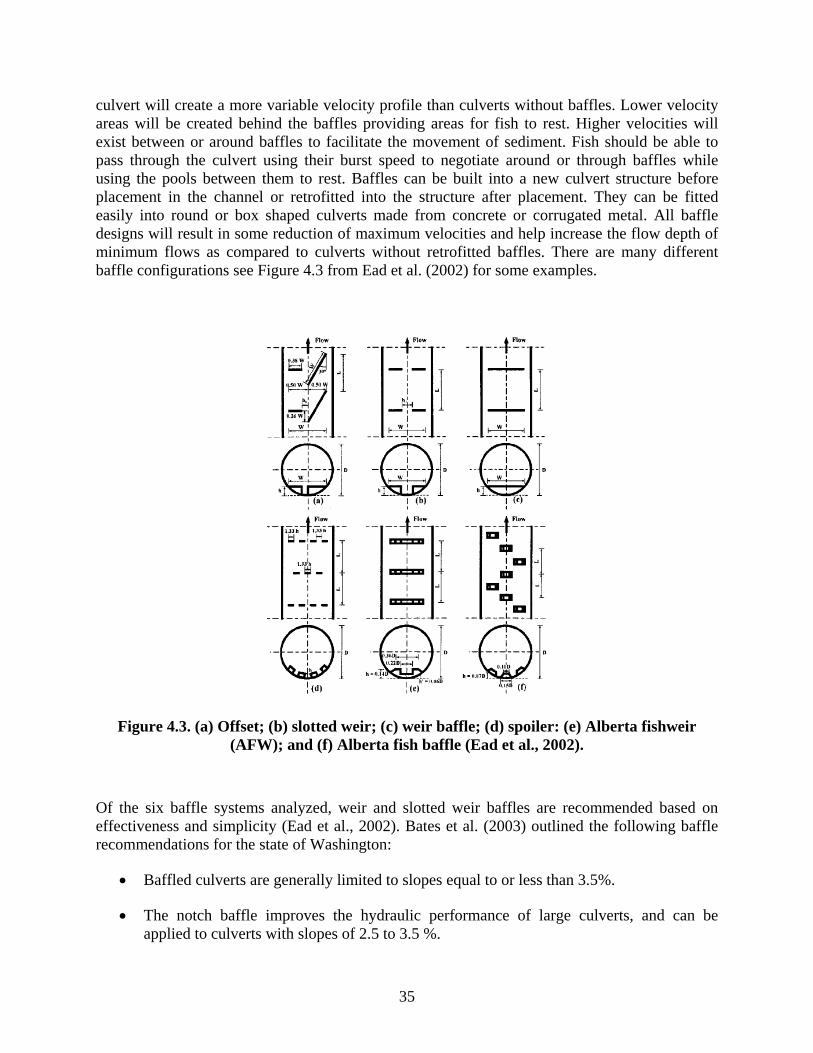
35
culvert will create a more variable velocity profile than culverts without baffles. Lower velocity areas will be created behind the baffles providing areas for fish to rest. Higher velocities will exist between or around baffles to facilitate the movement of sediment. Fish should be able to pass through the culvert using their burst speed to negotiate around or through baffles while using the pools between them to rest. Baffles can be built into a new culvert structure before placement in the channel or retrofitted into the structure after placement. They can be fitted easily into round or box shaped culverts made from concrete or corrugated metal. All baffle designs will result in some reduction of maximum velocities and help increase the flow depth of minimum flows as compared to culverts without retrofitted baffles. There are many different baffle configurations see Figure 4.3 from Ead et al. (2002) for some examples.
Figure 4.3. (a) Offset; (b) slotted weir; (c) weir baffle; (d) spoiler: (e) Alberta fishweir (AFW); and (f) Alberta fish baffle (Ead et al., 2002).
Of the six baffle systems analyzed, weir and slotted weir baffles are recommended based on effectiveness and simplicity (Ead et al., 2002). Bates et al. (2003) outlined the following baffle recommendations for the state of Washington:
• Baffled culverts are generally limited to slopes equal to or less than 3.5%.
• The notch baffle improves the hydraulic performance of large culverts, and can be applied to culverts with slopes of 2.5 to 3.5 %.

36
• Corner baffles might be used in culverts with slopes in the range of 1.0 to 2.5%. They are intended to provide wall roughness with a minimum potential for blockage by debris.
• Upstream baffles should be placed the distance of at least one culvert-diameter downstream of the inlet and should be high enough to ensure subcritical flow of the inlet at the high design flow.
Three recommended baffle configurations used in Washington State are shown in Figure 4.4.
Figure 4.4. Recommended styles of baffles for round and box culverts in Washington (Bates et al., 2003).
Choosing the right baffle configuration depends on a good analysis of stream flow, swimming capabilities of fish present, culvert shape and size, channel slope, bed material, and inlet or outlet conditions. The two main objectives are to create a flow environment favorable to fish passage and minimize turbulent conditions which might prevent juvenile fish passage. Most of the baffle recommendations are for salmonids which generally have greater swimming abilities than most of the warm water fish in Minnesota.
Advantages and Disadvantages
The advantages of baffles are a good alternative where a stream simulation design won’t work, as they can be retrofitted into existing culverts and cost effective for most situations.
The disadvantages include:

37
• Filling in with sediment • Reduction in the hydraulic capacity of a culvert • Catching woody debris and plugging a culvert • Getting torn out by rocks or wood • Increase in maintenance costs
Bates et al. (2003) recommends baffles only as a temporary fix to a fish passage problem until the culvert can be replaced with a more fish friendly design. Baffles are used in a small number of counties in Minnesota (Figure 4.5 and 4.6). In conversations with county engineers and DNR personnel in Minnesota we heard more negative comments about baffles than positive. Improper design and poor installation are the two main causes of baffle failure.
If designed properly and installed correctly baffles can be an effective technique to reduce velocities in culverts that previously provided a barrier to fish passage.
Figure 4.5. Offset baffles retrofit in round concrete culvert. (St. Louis County).

38
Figure 4.6. Rocks fashioned in as a slotted weir design. (St. Louis County). Costs The cost of using baffles to improve fish passage can be highly variable. A number of factors that influence the cost of using baffles are listed below:
• Number of baffles needed to reduce velocity • Culvert material • Culvert dimensions • New construction or retrofit • Baffle configuration • Site characteristics
The cost of installing baffles made from concrete is based on the cost of concrete per pound. Hancock Concrete, Hancock MN estimated baffle installation costs $0.15 to $0.25 per pound of concrete. The cost decreased as the amount of concrete increased per baffle. Using a slotted weir baffle configuration fitted to a 12 by ten foot concrete box culvert the cost per baffle would range from $250 to $500 depending on the baffle dimensions. There would also be a setup charge per culvert of $500.
Johnson Culvert of New Brighton, Minnesota gave a rough quote of $150- $250 per baffle for steel baffles installed in new corrugated metal culverts. Bates et al. (2003) calculated the construction cost per baffle from six different projects in the state of Washington at $470.

39
The county board of directors for Humboldt County California was quoted as saying it cost $8,000 to $10,000 to retrofit 12 baffles in a concrete box culvert and install an outlet pool weir.
Personal communications with the Oregon Department of Transportation indicated a cost of $1000 to $8000 dollars to retrofit a culvert with baffles.
The range of baffle cost outlined above per culvert is $1000 to $8000 depending on the factors bulleted at the beginning of this cost discussion. This gives an approximate average cost per culvert of $4,000. The average cost per culvert for baffles of $4,000 is 12.5 percent of $32,000 the average bankfull width culvert cost. The cost of baffles increases with increasing culvert size and slope.
Roughened Channels
Bates et al. (2003) defines roughened channels as:
A graded mix of rock and sediment built into a culvert to create enough roughness and hydraulic diversity to achieve fish passage. Increased roughness creates diversity in flow velocities and patterns, which, in turn, provides migration paths and resting areas for a variety of fish sizes.
Hotchkiss and Frei (2007) explained the difference between roughened channels and stream simulation as:
Roughened channels can be designed to have banklines, shallow water margins, and other diversity similar to stream simulation designs, the difference between a roughened channel as defined by fish passage experts and stream simulation is that the roughened channel uses channel dimensions, slope, and material to create depths, velocities, low turbulence, and a hydraulic profile suitable for a target species to pass through. This is somewhat equivalent to the hydraulic design option for culverts. The bed material of a roughened channel is not intended to evolve as a natural channel with bed material scouring and replenishing; it is a fixed semi-rigid structure. Individual rocks are expected to adjust position and location but the larger grain sizes are not expected to scour out of the reach.
Roughened channel designs could be used where a natural stream bottom design (Stream Simulation) bed keeps getting washed out of a culvert or can’t reduce the flow velocity low enough for fish passage. When rock is placed into a previously installed culvert the reduction in flow capacity needs to be taken into account. Care needs to be taken to properly size the rock so they won’t be washed out of the culvert. Bates et al. (2003) recommends using a 100 year peak flow to size the rocks with the largest rock not exceeding one-quarter of the culvert diameter. Rock spacing should leave enough room between rocks so larger fish can negotiate the culvert under low flow conditions.
Figures 4.7 and 4.8 depict two examples of culverts with roughened channels in Minnesota.
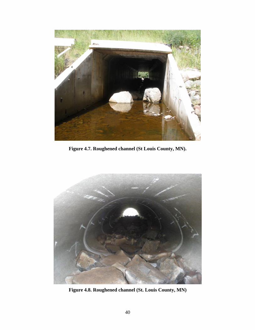
40
Figure 4.7. Roughened channel (St Louis County, MN).
Figure 4.8. Roughened channel (St. Louis County, MN)

41
Costs The costs associated with installing roughened channels in culverts are influenced by the following;
• Culvert dimensions • Size of rock • Availability of rock • Site characteristics
As the size of the culvert increases so will the volume of rock needed to provide a roughened channel. As the size of the rock increases so does the purchase price of the rock. Multiple trips may be required to transport larger rocks. Larger equipment may be required on site to install rock into the culvert. If the right rock is available in the stream or close by it will be much cheaper. If equipment access to the culvert is limited due to terrain or culvert size, rock may need to be placed in the culvert sections on the roadbed before they are set in place. Three installation cost scenarios for different rock sizes are given in Table 4.5. The culvert size used for these scenarios is a 63 foot long 12 by 10 foot box culvert.
Table 4.5. Estimated Installation Costs of Roughened Channels
Rock size (inches)
Price/Ton Transportation cost ($2/mile)
Equipment Rental($150/hour)
Total Cost Installed
6-15 $50 $100 4 hours $900 24-36 $80 $200 4 hours $2,000 36-60 $150/ $300 4 hours $2,100
If we average the three scenarios the project cost for material and equipment is $1,700. Design work and supervision on site is estimated at $1,500. This gives a total average cost of $3,200. Compared to the average bankfull barrel cost of $32,000, placing a roughened channel inside a culvert would be approximately 10% of the culvert cost.
Backwater Weirs
Backwater weirs, such as that shown in Figure 4.9, are placed downstream of the culvert outlet and set at an elevation high enough to backwater perched culverts or reduce velocities by backing water up into the culvert. In addition weirs can act as grade control structures protecting against channel incision and providing increased habitat through the formation of the downstream scour pools. There is an art to constructing backwater weirs as described in California Fish and Game (2007), a guidance document:
Their durability and passage effectiveness depends to a very large degree on the size and quality of material used, the care and skill of the hand labor or equipment operator,
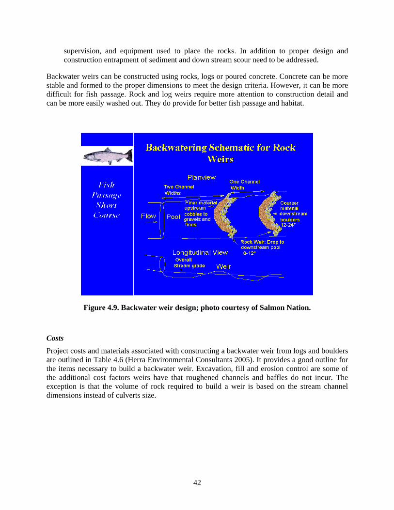
42
supervision, and equipment used to place the rocks. In addition to proper design and construction entrapment of sediment and down stream scour need to be addressed.
Backwater weirs can be constructed using rocks, logs or poured concrete. Concrete can be more stable and formed to the proper dimensions to meet the design criteria. However, it can be more difficult for fish passage. Rock and log weirs require more attention to construction detail and can be more easily washed out. They do provide for better fish passage and habitat.
Figure 4.9. Backwater weir design; photo courtesy of Salmon Nation. Costs
Project costs and materials associated with constructing a backwater weir from logs and boulders are outlined in Table 4.6 (Herra Environmental Consultants 2005). It provides a good outline for the items necessary to build a backwater weir. Excavation, fill and erosion control are some of the additional cost factors weirs have that roughened channels and baffles do not incur. The exception is that the volume of rock required to build a weir is based on the stream channel dimensions instead of culverts size.

43
Table 4.6. Herra Environmental Consultants Costs for a Log Boulder Weir
Item Quantity Unit Price/ unit
Total
Mobilization 1 LS $500 $500 Flow Diversion/Fish Removal
1 LS $600 $600
Excavation 30 CY $15 $450 Backfill w/fish mix 10 CY $35 $350 Log - 18” dia x 25’ 2 EA $500 $1,000 Boulder Materials 15 TON $60 $900 Weir Construction (log, rock, bank material placemen
1 LS $500 $500
Plantings- Live Stakes 180 EA $2 $360 Erosion Control Blanket 360 SF $1 $360 Site Restoration 1 LS $500 $500 Subtotal $5,500 $5,500 State Sales Tax on Construction 8.8% $500
8.8 $500
Contingency/Safety Factor 30% $1,700
30 $1,700
Total $7,700
$7,700
In British Columbia two downstream weirs were installed to backwater a perched culvert at a total cost of $10,000 (Makenzie Canimred Tributary, British Columbia) as outlined in Table 4.7.
Table 4.7. Cost of Installing Two Backwater Weirs
Site plan Preparation $2,000 Rip Rap $4,500 Supervision $2,000 Machine time $1,500 Total $10,000
The Washington Department of Fish and Game publication estimated rock weir construction costs ranging from $75 to $200 per linear foot. These numbers were based on a cost of $25 to $80 per cubic yard for rock and installation of rock between $50 and $100 dollars per cubic yard.

44
The range of values was influenced by cost of available rock, proximity of source to the construction site, and equipment and operator costs.
The average cost of the three presented examples above would be between $2,000 and $7,700 or $4,850. Construction of backwater weirs would cost about 15% of the average bankfull culvert cost of $32,000. Another better comparison might be to stream width. The amount of material needed to construct a backwater weir is dependant on stream width and bank profile, not culvert dimensions. The average bankfull width from the 12 reported work plans was 14.8 feet. It would cost approximately $328 per foot to install a backwater weir based on an average cost of $4,850 and an average bankfull width of 14.8 feet.
Meet Conventional Culvert Design Requirements
The following discussion refers to the use of baffles, roughened channels and backwater weirs. Some of the conventional design objectives for culverts are:
• Safely provide public transportation • Remain stable and pass worst case design flood • Minimize maintenance problems • Reduce upstream flooding potential • Control scour and erosion above and below culvert
There is limited literature as to how well these alternative designs are performing with respect to the above conventional culvert objectives. Also, there is a lack of data on how well alternative designs are actually performing their design function. The following comments are interpretations of the authors.
If designed properly the alternative designs should have a minimal effect on safety and ability to pass design flows. Erosion and scour should not be increased, and if designed properly may be reduced.
Maintenance issues could be increased as all three alternative designs have the potential to catch sediment and debris. Debris accumulating in a culvert due to baffles or roughened channels could significantly reduce the hydraulic capacity of the culvert.
The design life for these alternatives probably is likely shorter than for the structure itself. The literature provides a number of examples of baffles and rocks being washed out of culverts. In conversations with county and DNR officials we heard of two cases in which baffles were washed out of culverts in Minnesota. This may suggest the use of these designs in retrofit situations but for complete replacement a MESBOAC or Stream Simulation design may be preferred.
Summary Chapter 4
Baffles, roughened channels and backwater weirs were identified as alternative designs currently being used in Minnesota. These alternative methods are not designed as a replacement for

45
conventional culvert designs, but as an addition to an in-place design to facilitate fish passage. Generalized costs were calculated for all three designs. Costs were calculated as a percentage of the average bankfull width culvert from the 12 work plans examined in this report. For these cases the cost of the culvert structure is generally more than half of the total project cost. Tying the cost of alternative designs to the cost of the culvert as a percentage should allow an estimate of alternative design costs as the scale of the project increases or decreases. In the case of backwater weirs the cost per foot of stream width was used as well as bankfull culvert cost.
Material costs, transportation, design, labor, and equipment were considered in calculating the cost of the alternative designs. Information about project specific conditions such as access to the stream bed, time of the year, location of utilities, construction sequence and permits were not considered but could greatly influence the total cost of the project.
A summary of the costs associated with the three alternative designs is presented in Table 4.8
Table 4.8. Alternative Design Cost as a Percent of Bankfull Width Culvert Cost
Design Range ($) Average Cost % of Culvert Cost Baffle $1,000- 8,000 $4,000 12.5% Roughened Channel $2,400- 3,600 $3,200 10% Backwater Weir $2,000-7,700 $4,850 15.1%
Baffles have material, design and installation costs but little in terms of transportation costs. Transportation of rock or logs as well as the expense of the proper equipment to handle it onsite, play a big role in roughened channel and backwater weir design costs. Backwater weir designs are more expensive because they require additional excavation or fill and erosion control beyond that of the culvert installation. If done at the time of culvert installation, mobilization costs for all three designs will be cheaper, as supervision, labor, and equipment will already be onsite.
The lack of available literature and research make it difficult to assess if the alternative designs meet conventional culvert objectives. Issues related to plugging of culverts due to debris, reduced hydraulic capacity and structural failure are concerns expressed in the literature and locally in Minnesota.
Proper design seems to be the key to the success of these alternative designs. It requires a diligent effort on the part of the designer to properly assess the bed load, parent material, and stream hydraulics before a design method is chosen. Proper installation is also important as all of these methods increase the roughness coefficient of the channel and are thus exposed to greater stream energy.
If designed properly and installed correctly they should meet all of the traditional objectives of culvert design. In addition, they should provide for fish passage, and in the case of Stream Simulation methods, stream continuity.

46
Chapter 5: Summary
Overall the tools and techniques used in the coastal U.S. are applicable to the Upper Midwest. In terms of hydraulics and channel maintenance, the problems creating blockage of fish passage are similar: excess drop at culvert outlet, high in-pipe velocity and/or turbulence, inadequate water depth in pipe, excess pipe length without fish resting space and debris or sediment accumulation in-pipe. The major differences are fish species, stream geomorphology, hydrology, and prioritization of the issues and the types of fish species targeted.
There is not a regional or statewide ranking or prioritization system for fish passage in the state that can be used to identify high priority road crossings that require more analysis and design.
Some aspects of different alternative designs are being implemented in different areas of the state. Usually in response to specific local conditions concerning fish passage; trout streams in southeast and steeper gradient streams in northeast. Some of the different techniques being used are: low flow channels with multiple culverts, V-notch weirs and backwater weirs, culvert alignment, rock baffles inside culverts and MESBOAC. Most of the design expertise for fish passage culverts is with the DNR. As a result, the data collection and type of design chosen falls on DNR personnel. The function of these alternative designs has not yet been evaluated.
The main components of the MESBOAC design burying the culvert bottom, matching bankfull width and offsetting multiple culverts were fit into the footprint and maintained the design objectives of headwater, stage increase and flood capacity of the conventional design culvert. If the proposed additional benefits beyond improved fish passage of reduced erosion and maintenance costs prove to be true that could offset the additional costs associated with needing a larger culvert for MESBOAC. For all cases examined, except for one, the MESBOAC design would cost more than the corresponding conventional design. The increase in cost for the culvert structure ranged between -5 and 33%. Matching culvert and channel slope plays an important role in affecting flow velocities; it has little effect on increasing the cost of a project.

47
Chapter 6: Questions for Further Consideration
Several questions have arisen during the conduct of this project, questions outside the scope of the current work, but related to it. These questions are listed in the following.
What is the real impact of conventional culvert design on fish populations and aquatic life passage in Minnesota? Investigating this question will require a study that measures fish population health upstream and downstream of existing conventional installations.
Do the purported ecological improvements and reduced maintenance costs associated with the MESBOAC design offset the additional installation costs? Investigating this question will require that we first examine whether there are ecological improvements with the MESBOAC design, and also whether the MESBOAC design reduces maintenance of culvert installations. Once this is established it will be necessary to apply economics to determine the costs of installations and the economic value of the benefits.
Do we need a statewide guidance document addressing regional fish concerns and local geographical conditions that suggest a best fit culvert design conventional or alternative? This question addresses the fact that decisions regarding fish passage at road crossings are usually made at a regional or county level. Would such decisions be helped by a guidance document? The recent report by Beavers et al. (2008) may point in the appropriate direction to take for this. The goal of the study was to assess the fish passage issue at road crossings and prioritize the culverts that posed the greatest impact to aquatic life passage. A GIS data base was established based on topography, hydrology, road crossings and local fish species. Different filters were applied to the data to prioritizing the road crossings at a regional level. A culvert assessment protocol was established to assess culverts for fish passage. A training manual was developed to standardize the assessment and data collection process.

48
References
Bates, K. K., B. Barnard, B. Heiner, P. Klavas, and P.D. Powers, 2003. Design of Road Culverts for Fish Passage. Washington Department of Fish and Wildlife, Olympia, WA.
Beavers, A. E., H.R. Hotchkiss, and C.M. Belk, 2008. Fish Passage at UDOT Culverts: Prioritization and Assessment. Brigham Young University, Department of Civil and Environmental Engineering.
Bickford, S.A. and J.R. Skalski, 2000. “Reanalysis and interpretation of 25 years of Snake-Columbia River juvenile salmonid survival studies.” North American Journal of Fisheries Management. 20: 53-68.
California Fish and Game, 2007. Fish Passage Design for Road Crossings: An Engineering Document Providing Fish Passage Design Guidance for Caltrans Projects, May.
Clarkin, K., A. Conner, M.J. Furniss, B. Gubernik, M. Love, K. Moynan, and S.W. Musser, 2003. National Inventory and Assessment Procedure for Identifying Barriers to Aquatic Organism Passage at Road-stream Crossings, U.S. Department of Agriculture Forest Service National Technology and Development Program, San Dimas, CA.
Diebel, M., M. Fedora, and S. Cogswell. Identifying strategic opportunities for road crossing improvement to benefit stream fishes. Personal communication and Power point presentation May 2005.
Ead, S.A., N. Rajaratnam, and C. Katopodis, 2002. “Generalized Study of Hydraulics of Culvert Fishways.” ASCE Journal of Hydraulic Engineering, 128(11), 1018-1022.
Herrera Environmental Consultant., 2005. Preliminary Cost Estimates for Structural Sediment Controls, Seattle,WA.
Federal Highway Administration , 2008. Culvert hydraulic analysis program, HY-8, Version 7.1.
Frei, C.M., 2006. Design Of Fish Passage At Bridges And Culverts Hydraulic Engineering Circular – 26. M.S., Department of Civil Engineering, Washington State University, Pullman, WA.
Lenhart, C.F., 2002. “A preliminary review of NOAA Fisheries Dam Removal and Fish Passage Projects.” Coastal Management Journal, 31(1):77-96.
Magner, J., 2008. Personal communication, Dr. Joseph Magner, Senior Scientist, Minnesota Pollution Control Agency, St.Paul, MN.
Michigan Department of Natural Resources and Michigan Department of Environmental Quality. In review. Draft Sustainable Soil and Water Quality Practices on Forest Land -
49
IC 4011. Available: http://www.mi.gov/documents/dnr/1-6-PagesIC4011_269897_7.pdf (May 9, 2008).
Minnesota Department of Transportation, 2000. Drainage Manual, Minnesota Department of Transportation 2000. www.dot.state.mn.us/bridge/hydraulics/drainagemanual.
Minnesota Department of Transportation, 2008. General Public Waters Work Permit 2004-0001, files.dnr.state.mn.us/waters/watermgmt_section/pwpermits/General_Permit_2004-0001.pdf.
Peake, S., R.S. McKinley, and D.A. Scruton, 2000. “Swimming performance of walleye (Stizostedion vitreum)” Can. J. Zool. 78: 1686–1690.
Richter, B.D., D.P. Braun, M.A. Mendelson, and L.L. Master, 1997. “Threats to imperiled freshwater fauna.” Conservation Biology. 11 (5): 1081-1093.
Trautman, M.B. 1981. Fishes of Ohio. Ohio State University: Columbus, OH.
Washington Department of Fish and Wildlife, September 2004. “Stream Habitat Restoration Guidelines”.

Appendix A
Definitions Used in Text

A-1
Definitions are taken from Frei (2006). This was a M.S. thesis done on fish passage at Washington State University. The first 4 categories are from Frei’s work. We added a new category- Conventional culvert design, which gave no consideration to fish passage and sediment transport issues.
No Impedance (from Frei, 2006)
DEFINED - No Impedance – Crossing design produces no impedance to aquatic organism passage by spanning both the channel and floodplain. Aside from road removal or relocation, bridges provide optimum biological, geomorphic and hydraulic connectivity (Robison et al., 1999). Often bridges will be more expensive to install and have shorter effective lives than culverts (Venner Consulting and Parsons Brinkerhoff, 2004). The No Impedance procedure will not be described further.
Geomorphic Simulation (from Frei, 2006)
DEFINED – Geomorphic Simulation approaches are based on recreating or maintaining natural stream reach geomorphic elements including slope, channel-bed width, bed materials, and bedform. The basis of these methods is the presumption that crossings matching natural conditions will readily pass fish that are moving in the natural channel. For this reason, analysis of fish passage flows is not required. Such techniques could be considered the “gold-standard” of fish passage, and provide a substantial degree of conservativeness. Geomorphic Simulation techniques are mostly a product of the Pacific Northwest, arising out of trial and error and experience within the region (Bates et al., 2006).
Hydraulic Simulation (from Frei, 2006)
DEFINED - Hydraulic Simulation techniques utilize embedded culverts, natural or synthetic bed mixes, and natural roughness elements such as oversized rock, to provide hydraulic conditions conducive to fish passage. These techniques operate on the assumption that providing hydraulic diversity similar, but not identical, to that found in natural channels will create a fish passable structure without checks for excessive velocity or turbulence. Many techniques are based on regional design experience. Regardless of specific criteria, Hydraulic Simulation will generally have the benefit of creating smaller spanning structures that have a reduced cost when compared to Geomorphic Simulation.
Hydraulic Design (from Frei, 2006)
DEFINED - Hydraulic Design techniques create water depths and velocities that meet the swimming abilities of target fish populations during specific periods of fish movement. General considerations include the effect of culvert slope, size, material, and length. Flow control structures such as baffles, weirs, or oversized substrate are commonly utilized to create adequate hydraulic conditions.
Hydraulic Design is applicable to retrofits, new, and replacement culverts. This technique generates a smaller diameter culvert that keeps cost of materials and installation to a minimum while still meeting fish passage criteria including average cross sectional velocity, flow depth, and drop height. Hydraulic Design is specifically tailored to meet target fish species
A-2
requirements, but produces a less conservative design than Geomorphic or Hydraulic Simulation. These designs are applicable in areas where stream grade is at or near bedrock, and at slopes up to 5% (Robison et al. 1999; Bates et al. 2003; Katopodis, 1992). Fishway design may be applicable up to a 25% slope depending of fish species and life stages present (Katopodis, 1992).
Conventional Culvert Design
Conventional design focused on sizing culverts appropriately to pass a given design storm, in the range of the 5 to 25 year, 24 hour storm. Fish passage issues were not addressed because awareness of fish passage problems was not widespread. The focus was on moving water downstream quickly and protecting road infrastructure.

Appendix B
Fish Passage Success in East & West Coast and Midwestern Fishes
B-1
Table B.1. Success of Fish Passage for East Coast Diadromous Fish
EAST COAST SPECIES Common Name
Scientific Name Response of fish to passage efforts References (ordered by date)
Sturgeon (Atlantic, Gulf and Shortnose)
Acipenser sp. (oxyrhynchus, oxyrhynchus desotoi, and brevirostrum)
Very limited use of ladders, do not swim through turbulent flow. Success with elevators on Connecticut River.
Kynard, 1998; NMFS 1998
Blueback Herring
Alosa aestivalis Can use ladders Moffitt et al., 1982; Loesch, 1987; Fary and O’Roark, 1999; Haro et al., 1999
Alewife Alosa pseudoharengus
Good success with ladders Loesch, 1987; Fary and O’Roark, 1999
Hickory Shad
Alosa mediocris Life history not well known; some observations of fish ladders use have been recorded
Setzler-Hamilton and Hall,1992
Alabama shad
Alosa alabamae Limited knowledge of fish ladder utilization.
Barkuloo et al., 1993; NMFS, 2000b
American Shad
Alosa sapidissima
Variable success with fish ladders. Do not use ladders as easily as alewife or salmon. Good success with elevators on Susquehanna River
Moffitt et al., 1982; Rideout et al., 1988; Haro et al., 1998; Haro et al., 1999; SRAFRC, 2000
American Eel
Anguilla rostrata Require special considerations to achieve passage: coarse, roughened substratum needed for elvers to pass upstream
OTA, 1995
White Perch Morone americana
Can use ladders (semi-anadromous only in southern part of range). Limited knowledge of fish ladder utilization.
Fary and O’Roark, 1999
Rockfish or Striped Bass
Morone saxatilis Juveniles can use ladders, adults do not use ladders
Moffitt et al., 1982; Setzler-Hamilton and Hall, Jr., 1992
Rainbow smelt
Osmerus mordax Not known to use ladders. Limited knowledge of fish ladder utilization.
Yellow Perch
Perca flavescens Sporadic use of ladders reported. Limited knowledge of fish ladder utilization.
Fary and O’Roark, 1999
B-2
Atlantic Salmon
Salmo salar Strong swimming and jumping ability, can use ladders
Moffitt et al., 1982; Blackwell and Juanes, 1998; Haro et al., 1998; Laine et al., 1998
Sea lamprey Petromyzon marinus
Limited success in standard ladders. Addition of bristles to ladder surface may facilitate passage. Good success with fish elevators
Stier and Kynard, 1986; Halloway, 1991; Haro and Kynard, 1997; Laine et al., 1998
Other Species
Unknown for most non-game and freshwater species
Schwalme and Mackay, 1985; Slatick and Basham, 1985; Katopodis, 1991; Mallen-Cooper, 1994; Sorenson et al., 1998; Fary and O’Roark, 1999

B-3
Table B.2. Success of Fish Passage for West Coast Diadromous Fish
Common Name
Scientific Name
Response of fish to passage efforts References
Salmonids Bull, brown trouts
Salvelinus sp.(trutta and confluentus)
Coastal Cutthroat Trout, Steelhead Trout, Pink, Chum, Coho, Chinook, and Sockeye salmon
Oncorhynchus sp. (clarki clarki, gobuscha, keta, kisutch, mykiss, nerka, and tshawytscha)
Very good jumping ability and ability to use ladders. During downstream migration of juveniles there are major losses at large hydroelectric dams, caused by entrainment in turbines, migration delays and increased predation in reservoirs. Irrigation ditches and diversion kill many young salmon also.
Francfort et al.,1994; Bates and Powers, 1998; Bickford and Skalski, 2000; Venditti et al., 2000
Non-salmonids River lamprey Lampetra ayresi Limited knowledge of fish ladder
utilization Laine et al., 1998
Pacific lamprey
Lampetra tridentata
Can pass denil ladders on Columbia River
Slatick and Basham, 1985
Green sturgeon
Acipenser medirostis
Limited knowledge of fish ladder utilization
Houston, 1988
White sturgeon
Acipenser transmontanus
Occasional use of ladders reported, good use of fish locks.
Warren and Beckman, 1993
Smelt (eulachon, longfin, and delta)
Thaleichthys pacificus, Spirinchyus thaleichthys, Hypomesus transpacificus
Limited knowledge of fish ladder utilization. Not known to use ladders.
Musick et al., 2000

B-4
Table B.3. Fish Species of Importance for Fish Passage in Upper Midwest
Common name
Scientific Name
Response of fish to passage efforts References
Pikes Esocidae Fairly successful Perch Percidae Walleye, perch, panfish. Walleye
have had less success with fish passage than salmonids
Peake et al., 2000
Salmon/trout Salmonidae Successful for most species (found in north shore of Lake Superior, “Driftless” region of SE Minnesota and SW Wisconsin
Sturgeon Acipenseridae Swim on bottom, different behavior Luther Aadland work in Red River
Catfish Ictaluridae Less known here
Suckers Catostomidae Less known here, some passage observed
Minnows Cyprinidae little known here

Appendix C
Endangered, Threatened and Special Concern Fish Species in Minnesota and their Occurrence within Minnesota

C-1
The state is divided into 8 river basins (Figure 2.2). Miss = Mississippi River, Minn = Minnesota River, Mo = Missouric River and Conser st = conservation status. e = endangered, sc = special concern.
Distribution symbols include; X = present in basin, WI = in Wisconsin portion of basin, SD = South Dakota portion of basin, IA = Iowa portion of basin, L = below Taylor’s Falls, # = extirpated from basin. (Source: Fishes of Minnesota)
Taxonomic group Common name
Red
R
Rainy
R
U
Miss
R
S u p e r i o r
St
Croi x
Minn
R
M o
R i v e r
L
M i s s
R
C o n s e r
S t
Petromyzontidae lampreys
Ichthyomyzon fossor
northern brook lamprey X X WI X sc
Ichthyomyzon gagei
southern brook lamprey X sc
Acipenseridae sturgeon
Acipenser fulvescens lake sturgeon R X X X X X sc
Clupeidae herring
Alosa chrysochloris skipjack herring L# # X sc
Cyprinidae minnows
Erimystax x-punctatus gravel chub X sc
Hybopsis amnis pallid shiner # X sc
Notropis anogenus pugnose shiner X X X WI X IA X sc
Notropis nubilus Ozark minnow X sc
Notropis topeka Topeka shiner X # E
Catostomidae suckers

C-2
Cycleptus elongatus blue sucker X X SD X sc
Ictiobus niger black buffalo X IA X sc
Ictaluridae catfish
Ictiobus niger black buffalo X IA X sc
Noturus exilis slender madtom X
Salmonidae Salmon/trout
Coregonus kiyi kiyi X sc
Coregonus zenithicus shortjaw cisco X X sc
Percopsidae Trout perch
Aphredoderus sayanus pirate perch X sc
Fundulidae killifish
Fundulus sciadicus plains topminnow X sc
Moronidae bass
Morone mississippiensis yellow bass X sc
Percidae perch
Crystallaria asprella crystal darter L X sc
Etheostoma microperca least darter X X X WI X X sc
Percina evides gilt darter X WI sc

Appendix D
County Engineer Survey

D-1
The following survey was administered to county engineers at the January 17, 2008 county engineers’ meeting held in St. Paul, Minnesota. The purpose of the survey was to evaluate the current state of knowledge and of application of alternative methods for culvert design among county engineers in Minnesota. Summary responses to the questions are also presented.
1. For your region do you have an inventory of culverts under 10 feet in diameter on public waters?
Yes 3
No 21
Partial 6
1b. Does your inventory provide assessment of the culvert condition?
Yes 3
No 27
2. What method is most commonly used in designing culvert road crossings?
Hydraulic Conveyance
15
Mn/DOT 7
Same as what is in place
3
SCS 2
MESBOAC ½
TR55 ½
2b. Who does the culvert design work?
In house design for smaller culverts, larger culvert designs sent out to consulting firms.

D-2
3. Are you familiar with alternative culvert designs that emphasis fish passage or uninterrupted natural stream conditions through the culvert?
Yes 15
No 10
Somewhat 4
4. How much input do you receive from DNR on requirement for fish passage?
Yes 7
No 9
Some 15

Appendix E
DNR and Area Hydrologists Survey

E-1
The following survey was administered to DNR Fisheries and area hydrologists during the month of March, 2008. The purpose of the survey was to evaluate the current state of knowledge about alternative methods for culvert design, the degree of uniformity of design criteria, and the degree of interaction between DNR and county engineer’s counterparts regarding culvert design. Summary responses to the questions are presented
. 1. Please rate the importance of the following criteria on culvert design in your area.
The responses were averaged and listed below in order of importance.
Fish passage 1.85
Controlling wetland water elevations upstream and downstream
2.07
Flood capacity, flood plain mgmt 2.07
Match existing channel flow characteristics 2.07
Future maintenance and operating cost to road agency 2.37
Agricultural: water level effects on adjoining lands 2.64
Total installation cost to road agency 3.04
2. How familiar are you with any of the alternative design methods or concepts?
0
2
4
6
8
10
12
14
not familiar somewhatfamiliar
familiar very familiar

E-2
3. What percent of the culverts installed in your area incorporate some form of alternative design such as geomorphic, hydraulic design or hydraulic simulation, defined in the introduction?
0
2
4
6
8
10
12
14
0-10% 10-30% 30-60% 60-90% 90-100%
4. What criteria are used to determine the need for an alternative design versus a conventional approach?
Fish passage concerns 13
No experience or unsure 4
Project cost 2
Stream function 2
Replace same as existing 1
Follow permit requirements 1

E-3
5. How well are alternative designs maintaining their intended function?
0
2
4
6
8
10
12
14
16
notevaluated
not well atall
not verywell
somewhatwell
well very well
6. How well have alternative designs been accepted by local governments?
0
2
4
6
8
10
12
not well at all not very well somewhatwell
well very well

E-4
7. Do you have any information on costs associated with alternative design installations? Would you be willing to share the data?
No (or no info) 20
Alternative design is more expensive
3
Not much hard data 1
8. What comments have you received from contractors about installing alternative designs versus conventional designs?
None 18
Contractors are slow to adapt 4
Most accept when function is explained 3
Primarily work with county engineer 1
9. Are design engineers using commonly required “2 year peak flow shall not exceed 2 feet per second” flow velocities or are there local standards in place?
No 3
Not Sure 13
Pretty Much 1
Local Standards 1
Not unless requested 1
Varies, case by case 2
Yes 4
Skipped 3

E-5
10. If local flow velocities requirements exist that differ from the “2 year peak flow shall not exceed 2 feet per second” what are they and how were they determined?
NA or Unsure 12
None (old one is 2yr - 2 fps)
2
Other 6
Skipped 8
11. If velocities exceed the required “ 2 year peak flow shall not exceed 2 feet per second” what design is used to achieve the recommend velocity?
NA or Unsure 9
Pipe Size, slope, and sometimes baffles
4
Sandy Verry’s Design 1
Hydrologic Simulation 1
Channel Roughness added to decrease velocity
1
Skipped 8

Appendix F
Bridge and Culvert General Permit No. 2004-0001

F-1

F-2
F-3