(CORP) Development Guidelines (CA-010)
26
Transcript of (CORP) Development Guidelines (CA-010)

2
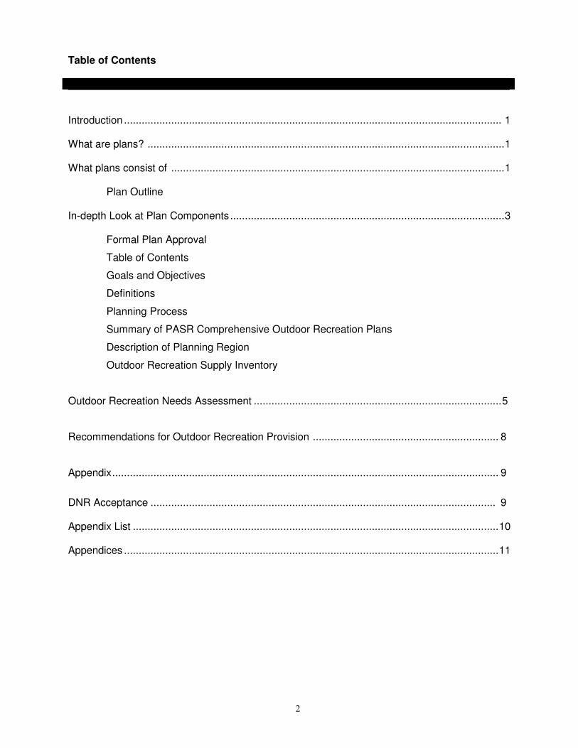
Table of Contents
Introduction ................................................................................................................................ 1 What are plans? .........................................................................................................................1 What plans consist of .................................................................................................................1 Plan Outline In-depth Look at Plan Components.............................................................................................3 Formal Plan Approval
Table of Contents
Goals and Objectives
Definitions
Planning Process
Summary of PASR Comprehensive Outdoor Recreation Plans
Description of Planning Region
Outdoor Recreation Supply Inventory
Outdoor Recreation Needs Assessment ....................................................................................5
Recommendations for Outdoor Recreation Provision ............................................................... 8
Appendix................................................................................................................................... 9
DNR Acceptance ..................................................................................................................... 9 Appendix List ............................................................................................................................10 Appendices ...............................................................................................................................11

1
Guidelines for the Development of
Local Comprehensive Outdoor Recreation Plans INTRODUCTION A prerequisite to participation in outdoor recreation grant programs is the adoption and subsequent Department of Natural Resources acceptance of a local comprehensive outdoor recreation plan. This requirement can be found in Chapter NR 50, Wisconsin administrative code for the following programs; Federal Land and Water Conservation Fund Program (LWCF), Aids for a the Acquisition and Development of Local Parks (ADLP), Urban Green Space Program (UGS) and Urban Rivers Grant Program (URGP). (Appendix 5) This document was prepared to help local units of government develop comprehensive park and recreation plans that will: 1) guide them in acquiring and developing public outdoor parks and recreation facilities, and 2) insure that plans meet the minimum requirements for participation in both state and federal programs. Planning occurs at several different levels. Comprehensive planning is an overall survey of the existing facilities within a given jurisdiction, and gives recommendations for future improvements. A comprehensive outdoor recreation plan (CORP) is only the first step in the development of a recreational park site or system. Being aware of other planning efforts from other agencies, municipalities, and non-profit organizations during the comprehensive outdoor recreation planning process enables your communities to consolidate recreational, resource management, and development efforts for an area, region or state. Communities may find it easier and more economical to implement the CORP recommendations when coordinated with other plans. Master planning, which follows the recommendations of the comprehensive plan, is an overall view and analysis of an existing or proposed park area. The purpose is to guide the orderly development of a park or recreational facility. Site Planning, is the detailed plan of how an area within a park or recreation area will be developed. Site plans supply the construction details needed to develop a facility recommended in the master plan. LOCAL COMPREHENSIVE OUTDOOR RECREATION PLANS What Are Plans? Local Comprehensive Outdoor Recreation Plans will vary in complexity depending on the size and population density of the municipality. It is unrealistic to expect that a small township in northern Wisconsin should complete a plan as complex as might be done by a densely populated municipality in the southeast part of the state. However, no matter how complex a plan is, it must contain a few basic elements if it is to be effective as a planning tool. The following outline includes the minimum requirements for all plans to gaining eligibility to participate in funding programs. Non-profit Conservation Organizations (NCO's) are eligible to participate in the Wisconsin Stewardship Program under the Urban Green Space and Aids for the Acquisition and Development of Local Parks programs. NCO's may adopt or carry out recommendations of a Comprehensive Outdoor Recreation Plan of the local unit of government in which the NCO project is located or use their land management plans that are required for participation in the Stewardship Programs.

2
What Does A Plan Consist Of? The following outline lists the required components needed for an approved plan. There is no order or format required for a plan, in fact we encourage communities to improvise and develop their own unique plan. I. Copy of the adopted Resolution or Minutes approving the Comprehensive Outdoor Recreation Plan II. Table of Contents III. Statement of need and parameters that the plan will establish IV. Goals and Objectives V. Definitions A. Terms B. Classifications VI. Planning Process A. Description of Process B. Amending the Plan VII. Summary of Past Comprehensive Outdoor Recreation Plans VIII. Description of the planning region A. Social Characteristics of municipality/planning region 1. Size 2. Population Trends and Projections 3. Ethnic background 4. Employment/unemployment 5. Age 6. Economy B. Physical Characteristics of the region 1. Topography 2. Water Resources 3. Climate 4. Soils 5. Flora and Fauna IX. Outdoor Recreation Supply Inventory
A. Natural Resources Available for Outdoor Recreation 1. Developed 2. Undeveloped B. Outdoor Recreation Facility Inventory
1. Number of Sites 2. Types of Park/Recreation Areas 3. Facilities Available at Sites 4. Current Condition of Park/Recreation Areas and Facilities on Sites
C. Accessibility for Persons with Disabilities

3
X. Outdoor Recreation Needs Assessment A. Public Input Assessment 1. Informal 2. Citizen Committees 3. Public Meetings and Workshops 4. Needs Assessment Surveys B. Need Standards 1. Recreation Open Space 2. Recreation Facilities C. State Comprehensive Outdoor Recreation Program (SCORP) XI. Recommendations for Outdoor Recreation Provision A. Action Program -- Capital Improvement Schedule (CIS) B. Operation and Maintenance 1. Existing Operation and Maintenance Responsibilities
2. Implications of CIS on Operation and Maintenance Capabilities C. Funding Programs 1. Local Funds 2. Available Grant Funding Programs XII. Appendix - Supporting data, tabular data, graphs, maps, tables In-depth Look at Plat Components I. Formal Plan Approval Obtain approval for your Local Comprehensive Outdoor Recreation Plan from the local governing body.
Each local government must include a copy of the resolution of adoption or minutes from the meeting adopting the plan. Communities included in the county outdoor recreation plan must also submit documentation indicating that they have adopted the county comprehensive outdoor recreation plan.
II. Table of Contents Include this section to give the reader a sense of how the plan was developed and show where the major
points of information are located by chapter and page. III. Introduction Provide a general statement that briefly discusses the reason for a comprehensive outdoor recreation plan
and what your community will accomplish with the plan. This statement could include the major points of what your plan will accomplish.

4
IV. Goals and Objectives List the goals and objectives you expect your plan to produce or write a mission statement to cover the
goals and objectives of your plan and state the philosophy of your park and recreation program. V. Definitions A. TERMS:
Define the terms used to describe programs, facilities and recommended actions proposed by the plan.
B. CLASSIFICATIONS: Defines the list of standards used to describe facilities recommended by your plan. These
classifications usually correspond to the National Recreation and Park Association's recreation, park and open space standards guidelines. Suggested guidelines for categorizing facilities can be found in Appendixes 10 and 11.
VI. Planning Process A. DESCRIPTION OF PROCESS: Give a brief description of the sequence of events that took place during the development of the
Comprehensive Outdoor Recreation Plan. Include landmark dates (public meetings, inventory gathering periods, draft plan presentation dates, etc.)
B. AMENDING THE PLAN: Plan amendments are common and should be considered part of the planning process. They
frequently represent good implementation or plan usage and should be acceptable for consideration by local decision-makers. Amendments must follow the same process as the original plan and should be outlined in this section. Amendments generally prolong the effectiveness of the parent plan.
VII. Summary of Past Comprehensive Outdoor Recreation Plans Review the history of outdoor recreation planning in your jurisdiction to help the reader comprehend the
present outdoor recreation situation, and to support the recommendations action made in the plan. VIII. Description of the Planning Region
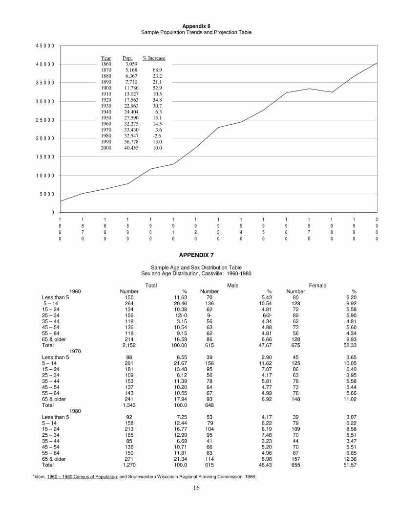
A. SOCIAL: Discuss social factors that are important to understanding your community and its recreation needs and potential. These may include but are not limited to: the size of the population; its geographic, age, sex, racial, and ethnic distribution; location of concentrations of minorities or senior citizens; number of disabled residents; socioeconomic levels including employment and unemployment. Discuss population trends and projections over the planning period. Include tables that provide information on population trends and age characteristics.
(See Appendix 6 and 7 as examples).
Note: Population projections for all municipalities are done each year by the following State agencies: Department of Administration, Department of Revenue and Department of Development (see Appendix 2 for addresses). In addition, population projections and other technical services are provided by county or the regional planning commissions serving your area.
B. PHYSICAL:
Provide a discussion of the physical factors in the community and region that are important to understanding your community and its recreation needs and potentials. These may include topography, water resources, climate, soils, environmental problems and concerns, and transportation systems. Maps displaying these features should be provided when available. A good inventory

5
will point out areas that are environmentally sensitive and may be targeted for protection or avoided for construction sites.
By recognizing trends in social and physical characteristics in your planning area, recreation facilities can be designed for maximum use. For example, a playground should be sited in any area with a large concentration of children and appropriate soils for construction. Remember, major features such as rivers or traffic arteries will influence the distances needed to travel in order to use recreational facilities.
IX. Outdoor Recreation Supply Inventory A. NATURAL RESOURCES AVAILABLE FOR OUTDOOR RECREATION USES: Include a list of all
areas available to the residents of a municipality for recreation purposes. List open space areas that have the potential to provide recreation opportunities whether they are currently available for public use or not. This inventory should include information on the size of the parcel, name of the park if so dedicated, current ownership, public access points, present use and future options.
B. OUTDOOR RECREATION FACILITY INVENTORY: Provide a detailed listing of all the facilities
available to the residents of the municipality or planning region, including number of sites, types of park/recreation areas, facilities available at sites, current condition of park/recreation areas and facilities on sites. This inventory can be general in nature concentrating on major facilities such as: softball diamonds, tennis courts, shelter buildings, restrooms, etc., or it can be a detailed listing of general as well as specific facilities such as picnic tables, grills, bike racks, etc. (Appendixes 8 and 9 provide samples of Recreation Supply Inventories.)
C. ACCESSIBILITY GUIDELINES: Assess the existing recreational facilities for accessibility to persons
with disabilities. Communities that seek grant funds have an extra incentive to conduct an accessibility evaluation because the priority ranking system provides additional credit to sponsors who include the process in their planning program. Persons with training in accessibility issues (including a good understanding of the Americans with Disabilities Act and Barrier Free Design Standards) should be consulted when conducting an evaluation of a community (an example of a facility accessibility checklist can be found in Appendix 12).
In addition to a survey of what is available, the community should include a program of compliance for facilities that do not comply with accessibility requirements. For example, if five restroom buildings in the community need improvements to make them barrier free, the plan should include a remodeling schedule. A second example would be to make accommodations so that a hearing impaired child could attend a playground storytelling event. (See example, Appendix 13)
Include definitions and guidelines in an appendix to give a better understanding of what is needed to implement the barrier free facility plan.
X. Outdoor Recreation Needs Assessment
Do a needs assessment to discover your community's most crucial recreational opportunities. Enroute to discovering the exact needs of the community, many other things can be accomplished by conducting a needs assessment, such as:
1. Citizens' opinions of how recreation services are being delivered. 2. What types of programs and facilities are wanted, what programs and facilities are currently being
used and what programs are being avoided. 3. The needs assessment will enable you to anticipate support levels for new facility and program
proposals as well as for proposals on user fees, operating hours and recreation marketing programs.

6
Generally, there are two basic methods for conducting a needs assessment: public input and recreation standards. Often both are used in varying degrees to gain the most accurate picture of community needs. Following is a description of each method.
A. PUBLIC INPUT METHODS FOR CONDUCTING NEEDS ASSESSMENTS: Public participation is an important element when planning your community's park and recreation
system. After all, the public will be using the parks. What better way to learn local demands than by involving the general public in the planning process?
How to elicit your community's needs is really up to you. What you are looking for is guidance from the people who will be using your recreational facilities. The following four public input methods are often used to assess needs within a community. Choosing the one, or combination, that best suits your community's needs will be based on available staff, time constraints, and financial resources.
1. INFORMAL: Rather than ask for citizen input, this system records questions and suggestions as they arise. As can be expected, the more vocal citizens and special interest groups will dominate in this type of assessment. Still, this approach has merit because it is important to consider the needs and demands of special interest groups
2. CITIZEN COMMITTEES: Citizen committees act as liaison between the public and the decision
makers. In many communities, prevailing Park and Recreation Boards serve as the citizens committee as well. Boards representing constituents reflect a number of opinions concerning recreation policies and issues. When developing brief surveys, this type of committee helps to gain general impressions of the public's need.
It is important to establish a committee that represents the entire population of the municipality. Such a committee may include senior citizens, minority groups, disabled persons, community leaders, etc. An ideal committee consists of both citizens and elected officials. Citizens can provide needed public input and opinion, while the elected officials can help muster political support in the latter stages of plan adoption and implementation.
3. PUBLIC MEETINGS AND WORKSHOPS: Public meetings and workshops are the most common method for measuring citizen needs. They offer the advantages of being relatively inexpensive and they allow for important dialogue between the public and the decision makers of the municipality. A major draw back of this method is that it can be extremely time consuming and therefore not as helpful when working under a strict time deadline.
One very simple, yet productive technique for gathering opinions from public meetings is known as the "modified nominal group process". In this process the public workshop is divided into small discussion groups. Each participant of the group is asked to answer a general question regarding park and recreation issues such as, "In your opinion what problems or issues must be solved to provide adequate recreation for this community in the next five years?" After allowing approximately 15 minutes for thought the participants are asked to list their answers. Each answer is recorded on a large sheet of paper by a designated group leader. Once all the issues have been recorded, they are ranked by the group in order of importance. After all groups have completed their discussions they reconvene and present their findings to each other. The final task is to establish the top ten issues of the whole group.
This process effectively generates many ideas from just one workshop. Also, it has the advantage of representing a cross-section of residents from the municipality or planning region.

7
4. NEEDS ASSESSMENT SURVEY: These can be the most valuable methods for obtaining citizen
opinion on recreation needs, problems, and issues within a municipality or planning region. Unfortunately, if not done properly, needs assessment surveys can produce misleading or useless data. If no one on your municipality's needs assessment team has experience writing or analyzing a "random sample survey" we recommend you contact one of the agencies offering technical assistance on planning listed in Appendix 1.
Using any one, or a combination of the methods listed above will help a municipality gain insight to the recreation needs and demands of the general public. Needs are then prioritized, high, medium, or low priority. It becomes important to compare projected needs against existing facilities. It is possible that needs established by the general public may not represent real deficiencies in recreation provisions for a municipality. Often, public issues and concerns stem from nothing more than a lack of information on the subject. For this reason it is important to compare existing open space areas and facility developments against a set of standards set up to help measure a park system's adequacy.
B. RECREATION NEEDS STANDARDS:
The standards system is another method of assessing a community's recreation needs. The National Recreation and Park Association (NRPA) developed standards to provide a scale against which the existing recreation system can be measured. Standards can be used to create guidelines for future needs.
Appendixes 10 and 11 provide examples of standards developed for recreation open space and for facility development. Typically, standards link acreage to the community's population or link the number of facilities to the population. In addition, service area standards are also used to determine recreational needs.
1. STANDARDS FOR RECREATION OPEN SPACE: A community's open space needs are generally
assessed using space standards. Space standards are the most widely used and common measure of a recreation system's adequacy. Total park and recreation space is normally expressed as a ratio of acres per population. Standards based on population can be helpful in assessing current and future open space needs and demand for the community. However, because a community may meet open space standards and still be deficient in park facilities, it is important to look at facility standards as well (see Appendix 10).
2. STANDARDS FOR RECREATION FACILITIES: Facility standards are similar to space
standards because they are expressed in facility units per population ratio. The purpose of evaluating a recreation system from a facility viewpoint, in addition to an open space viewpoint is to determine the amount of needed facility development in each recreation area (see Appendix 11).
Problems related to using facilities standards can be seen in the assumption of desired opportunities by the resident population. Example: A tennis court is needed based on the municipality's population. In reality, it is possible that very few people in the community enjoy playing tennis, which eliminates the need for this type of facility. In addition to the population based standards discussed above, it can be useful to analyze a community's recreational needs according to "service areas". This can be done for both open space needs and for facility needs. Each park and facility type will serve a geographical area of a certain radius. A drawback to this type of standard is that it does not take into account citizen preferences and barriers resulting from the natural and man-made physical landscape.
In general, it should be noted that population and service area standards assume that the needs and wants of individuals are similar in all areas to which the standards are applied. Service area standards assume upon reaching some threshold, an increase in the quantity of facilities results. Age, income, and education all contribute to people's recreational preferences, yet standards ignore these variables. Another problem with using standards is that they have been developed primarily for urban communities and have limited application to rural areas.

8
Despite these problems, standards have a place in recreation planning. Community leaders can use them to approximate of the adequacy of their park systems. The best advice is to use them cautiously and they should not be the only criteria for developing a needs assessment. The public input methods described earlier can be used to determine priorities and "perceived" need within the community. Standards can then be applied to the prioritized needs. By combining these two methods, it should be possible for a community to determine their most important recreation needs during the planning period. The next step will be to develop recommendations that highlight the community's plan for meeting the needs.
C. STATE COMPREHENSIVE OUTDOOR RECREATION PLAN:
The State Comprehensive Outdoor Recreation (SCORP) has information on recreational supply, demand, needs, priority and issues. Priority needs are listed for the state as a whole and for the six multi-county districts.
The SCORP should be used as a general guide to help in developing a local needs assessment. For the best results, it should be combined with more detailed local data on recreational opportunities, participation and demographics.
XI. RECOMMENDATIONS FOR OUTDOOR RECREATION PROVISION
Base local government recommendations for the implementation of outdoor recreation on the results of the supply inventory, needs assessment and SCORP findings. These recommendations should address two elements: 1) an action plan for future park acquisition and development; 2) a program for future operation and maintenance of the community's park system.
A. ACTION PROGRAM: Provide an action plan that solves or reduces deficiencies in a community's recreation system. A
good plan will identify the actions needed to be taken, where, by whom, and in what time frame. These actions can be identified by formulating a capital improvement schedule (CIS).
A CIS details anticipated acquisition and development for at least a five year period based upon the needs assessment. For each item listed in the CIS, indicate which year(s) in which the improvement will take place and its location within the park system. Clearly describe the improvement, estimate its cost, and provide a cost breakdown by anticipated funding source. Appendix 14 suggests one way to present this information.
B. OPERATION and MAINTENANCE:
1. Examine the operation and maintenance responsibilities of the existing park system, and review the implications of the capital improvement schedule (CIS) on your community's future operation and maintenance capabilities. Many communities jump head-first into ambitious recreation developments with little, if any, attention to operation and maintenance expenses. Communities often construct excellent facilities, only to have serious problems keeping them open for public use.
2. A municipality's park system operation and maintenance costs should be organized in a schedule
or calendar form. List all work required on a property for each year, by season. Break the list down to individual work items and, below each work item, list the tasks required to complete the work item. The next step is to estimate how much time is required between each task. A final step is to indicate cost estimates for each of the tasks, including staffing costs to operate and maintain the park system.

9
Most successful communities will prioritize major maintenance projects for their facilities and incorporate the projects into a five-year CIS. It would be wise to look beyond a five-year project planning calendar and anticipate major facility needs which usually occur beyond the five year period.
C. FUNDING PROGRAMS: 1. Identify existing and potential funding sources for the comprehensive outdoor recreation plan in
order to show how implementation of the plan will impact the community, and to show what level of investment is required to satisfy the community's needs.
2. A wide base of financial support can be built into the comprehensive outdoor recreation plan
through the identification and pursuit of potential funding sources. Funding sources can come in a variety of forms (local bonds, donations and state and federal grants and loans). Information for finding funding sources can be obtained from the Wisconsin Department of Natural Resources, Community Services Specialist (see Appendix 4 for appropriate region.)
XII. APPENDIX
Use this section to display your supporting data, tabular data, graphs, maps and tables. DNR ACCEPTANCE After a local government adopts the plan, it is then submitted to the appropriate regional Community Service Specialist (CSS) for acceptance. The Community Service Specialist evaluates the plan and if it meets the specification, a letter granting five years of eligibility is mailed to the local government. Communities are encouraged to send a draft plan to their Regional Community Services Specialist for review before submitting the final plan. If a plan does not meet DNR specifications, the CSS will document the deficiencies in a letter to the local unit of government. A revised plan can then be resubmitted.

10
Appendix 1: Wisconsin Department of Natural Resources, Ed; 1994. Who to Contact About Outdoor
Recreation Planning. Guidelines for the Development of Local Outdoor Recreation Plans Appendix 2:
Wisconsin Department of Natural Resources, Ed; 1994. Address for Agencies Providing Information and Technical Assistance to Local governments. Guidelines for the Development of Local Outdoor Recreation Plans.
Appendix 3:
Wisconsin Department of Natural Resources, Ed; 1994. Regional Planning Commissions List. Guidelines for the Development of Local Outdoor Recreation Plans.
Appendix 4:
Wisconsin Department of Natural Resources, Ed; 1994. Regional Community Services Specialist list. Guidelines for the Development of Local Outdoor Recreation Plans.
Appendix 5:
Wisconsin Administrative Code NR 50 and 51, Ed; 1990. Stewardship Program Requirements for Comprehensive Outdoor Recreation Planning.
Appendix 6:
U.S. Census of Population 1960-1980 Census of Populations; and Southwestern Wisconsin Regional Planning Commission, 1986.
Appendix 7:
Idem, 1960-1980 Census of Population; and Southwestern Wisconsin Regional Planning Commission, 1986.
Appendix 8: Sample Recreation Supply Inventory. Bureau of Community Financial Assistance, Wisconsin Department of Natural Resources, Ed. 1994
Appendix 9: Adams County Outdoor Recreation Plan, 1987-1992. Page 47, Table II
Appendix 10: Roger A. Lancaster, Ed; 1983. Recreation and Open Space Standards and Guidelines. Alexandria, Virginia: National Recreation and Park Association. Pages 56-57
Appendix 11:
Roger A. Lancaster, Ed; 1983. Recreation and Open Space Standards and Guidelines. Alexandria, Virginia: National Recreation and Park Association. Pages 60-61
Appendix 12: Department of Interior Section 504 Guidelines for Federally Assisted Park and Recreation Programs and Activities, March 1984; Section 504 Self Evaluation Guide, Appendix A, Part II No. 9-11, Part III No. 5-7.
Appendix 13: City of Algoma Comprehensive Outdoor Recreation Plan 1993-1997. Pages 33-34. Prepared by the Bay-Lake Regional Planning Commission.
Appendix 14: Village of Mount Horeb Comprehensive Outdoor Recreation Plan December 1992. Page 37. Prepared by Foth & Van Dyke (Consultants)

11
APPENDIX 1
WHO TO CONTACT ABOUT OUTDOOR RECREATION PLANNING If your municipality is interested in preparing an outdoor recreation plan, the following agencies can provide technical assistance. Most of the agencies prepare plans for specific communities and/or regional areas. Department of Natural Resources: the DNR has Community Service Specialists (CSS) who represent six districts throughout the state to aid municipalities in preparing outdoor recreation plans. Each CSS office provides technical and advisory assistance to all local governments in each region that request it. (See Appendix 4 for addresses and counties served). Regional Planning Commissions: these agencies prepare outdoor recreation plans for counties, cities, villages, and townships. They also develop regional outdoor recreation plans for the entire area they serve (See Appendix 3 for addresses and participating counties). County Planning Agencies: not all counties have planning agencies, those that do can offer assistance in developing recreation plans. Some counties prepare county-wide comprehensive outdoor recreation plans and may offer to include a section in the plan for communities within the county that request it. County Parks Commission: municipalities in counties that do not have a planning agency or are not part of a regional planning commission may contact the county parks commission. The parks commission's role is to address the recreational needs of a county and can do so with planning. They should have a staff which is responsible for developing recreation plans. University of Wisconsin Extension offices: these offices have access to useful information to help a community develop a recreation plan. If the county parks commission does not have staff for planning purposes, or if there is not a county planning agency or regional planning commission serving your area, Extension Offices may have staff people who are responsible for recreation planning. Private Planning Agencies: private planning agencies and engineering consulting firms can also assist you in developing an outdoor recreation plan. In many communities private firms have been contracted to develop a recreation plan. Independent Living Centers or the Easter Seals Society: these offices have technical and practical information regarding the development of designs and accommodations needed to provide barrier free access to public and private facilities. Student Interns: graduate students studying outdoor recreation, urban and regional planning, or any related field can be a good alternative for smaller municipalities to consider. These students have a good background in the fundamentals of planning and, therefore, can produce a quality outdoor recreation plan. Often smaller communities can hire a graduate student as an intern for the summer or during the school year for relatively low costs.

12
APPENDIX 2
Addresses for Agencies Providing Information and Technical Assistance to Local Governments State Agencies Wisconsin Department of Administration 101 E. Wilson Street Madison, WI 53702 (608) 266-1741 Wisconsin Department of Commerce (formerly Dept of Development) PO Box 7970 201 W. Washington Avenue Madison, WI 53703-7970 (608) 266-1018 Wisconsin Department of Natural Resources Bureau of Community Financial Assistance GEF 2, 8th Floor 101 S. Webster Street Madison, WI 53707 (608) 266-7555 Wisconsin Department of Revenue Bureau of Local Financial Assistance 2135 Rimrock Road PO Box 8971 MS 6-97 Madison, WI 53708-8971 (608) 264-6892

13
Appendix 3
Regional Planning Commissions
Bay-Lake Regional Planning Comm. Suite 450 S.E. Building - U.W.-Green Bay Green Bay, WI 54301-7001 E-mail: www.baylakerpc.org Telephone: (920) 465-2135 Fax: (920) 465-2823
Brown, Door, Florence, Kewaunee, Manitowoc, Marinette, Oconto, Sheboygan
Columbia, Dane, Dodge, Jefferson, Rock, Sauk Counties no longer members of a Regional Planning Commission
East Central Wis. Reg. Planning Comm. 132 North Main Street Menasha, WI 54952 E-mail: www.eastcentralrpc.org Telephone: (920) 751-4770 Fax: (920) 751-4771
Calumet, Fond du Lac, Green Lake, Marquette, Menominee, Outagamie, Shawano, Waupaca, Waushara, Winnebago
Mississippi River Reg. Planning Comm. 1707 Main Street, Suite 240 La Crosse, WI 53601 E-mail: www.mrrpc.com Telephone: (608) 785-9396 Fax: (608) 785-9394
Buffalo, Crawford, Jackson, La Crosse, Monroe, Pepin, Pierce, Trempealeau, Vernon
North Central Wis. Reg. Planning Comm. 210 McClellan St., Suite 210 Wausau, WI 54403 E-mail: www.ncwrpc.org Telephone: (715) 849-5510 Fax: (715) 849-5110
Adams, Forest, Juneau, Langlade, Lincoln, Marathon, Oneida, Portage, Vilas, Wood
Northwest Regional Planning Comm. 1400 South River Street Spooner, WI 54801 E-mail: www.nwrpc.com Telephone: (715) 635-2197 Fax: (715) 635-7262
Ashland, Bayfield, Burnett, Douglas, Iron, Price, Rusk, Sawyer, Taylor, Washburn and Tribal nations: Lac cu Flambeau, Bad River, St Croix, Red Cliff, Lac Courte Oreilles.
Southeastern Wis. Reg. Planning Comm. W239 N1812 Rockwood Dr., P.O. Box 1607 Waukesha, WI 53187-1607 E-mail: www.sewrpc.org Telephone: (262) 547-6722 Ex. 240 Fax: (262) 547-1103
Kenosha, Milwaukee, Ozaukee, Racine, Walworth, Washington, Waukesha
Southwestern Wis. Reg. Planning Comm. 719 Pioneer Tower 1 University Plaza Platteville, WI 53818 E-mail: www.swwrpc.org Telephone: (608) 342-1713 Fax: (608) 342-1220
Grant, Green, Iowa, Lafayette, Richland
West Central Wis.Reg. Planning Comm. Suite D2-401 800 Wisconsin Street, Mail Box 9 Eau Claire, WI 54703-3606 E-mail: wcwrpc.org Telephone: (715) 836-2918 Fax: (715) 836-2886
Barron, Chippewa, Clark, Dunn, Eau Claire, Polk, St. Croix

14
Appendix 4
Region Community Services Specialist Christine Halbur Northeast Region 2984 Shawano Avenue PO Box 10448 Green Bay, WI 54307-0448 (920) 662-5121 Fax: (920) 662-5413
Brown, Calumet, Door, Fond du Lac, Green Lake, Kewaunee, Manitowac, Marinette, Marquette, Menominee, Oconto, Outagamie, Shawano, Waupaca, Waushara, Winnebago
Lavane Hessler West Central Region 1300 W. Clairemont Avenue Call Box 4001 Eau Claire, WI 54702-4001 (715) 839-3751 Fax: (715) 839-6076
Adams, Buffalo, Chippewa, Clark, Crawford, Dunn, Eau Claire, Jackson, Juneau, La Crosse, Marathon, Monroe, Pepin, Pierce, Portage, St. Croix, Trempealeau, Vernon, Wood
Stefanie Brouwer South Central Region 3911 Fish Hatchery Road Fitchburg, WI 53711 (608) 275-3218 Fax: (608) 275-3338
Columbia, Dane, Dodge, Grant, Green, Iowa, Jefferson, Lafayette, Richland, Rock, Sauk,
Tom Blotz Southeast Region 2300 N. Martin Luther King Jr. Dr. Milwaukee, WI 53212 (414) 263-8610 Fax: (414) 263-8661
Kenosha, Milwaukee, Ozaukee, Racine, Sheboygan, Walworth, Washington, Waukesha
Diane Conklin Northern Region - Spooner 810 W. Maple Street Spooner, WI 54801 (715) 635-4130 Fax: (715) 635-4105
Ashland, Barron, Bayfield, Burnett, Douglas, Polk, Rusk, Sawyer, Washburn
Pat Zatopa Northern Region – Rhinelander 107 Sutliff Rhinelander, WI 54501 (715) 365-8928 Fax: (715) 365-8932
Florence, Forest, Iron, Langlade, Lincoln, Oneida, Price, Vilas, Taylor

15
Appendix 5
NR 50.06(4) Land and Water Conservation Fund Program "General Provisions. (a) Applicants are required to submit comprehensive outdoor recreation plans which have been formally approved by resolutions passed by the local governing bodies; or applicants may qualify for eligibility if their proposed projects are identified in approved plans of other units of governments." NR 51.910 Aids for the Acquisition and Development of Local Parks An approved local comprehensive outdoor recreation plan is required to be eligible to submit applications to the local park aid program." NR 51.920 Aid for the Acquisition of Urban Green Space (23.09(19)) "The application shall include a comprehensive description of the proposal for the urban green space acquisition, plan for the development and management of the land and any other information required by the Department." NR 51.930 Urban Rivers Grant Program "Projects must be supported by a town, village city, county or tribal government Comprehensive Outdoor Recreation Plan."
16
Appendix 6 Sample Population Trends and Projection Table
0
5 0 0 0
1 0 0 0 0
1 5 0 0 0
2 0 0 0 0
2 5 0 0 0
3 0 0 0 0
3 5 0 0 0
4 0 0 0 0
4 5 0 0 0
1
8
6
0
1
8
7
0
1
8
8
0
1
8
9
0
1
9
0
0
1
9
1
0
1
9
2
0
1
9
3
0
1
9
4
0
1
9
5
0
1
9
6
0
1
9
7
0
1
9
8
0
1
9
9
0
2
0
0
0
APPENDIX 7
Sample Age and Sex Distribution Table
Sex and Age Distribution, Cassville: 1960-1980
Total Male Female 1960 Number % Number % Number %
Less than 5 150 11.63 70 5.43 80 6.20 5 – 14 264 20.46 136 10.54 128 9.92 15 – 24 134 10.38 62 4.81 72 5.58 25 – 34 156 12/-0 9- 6/2- 89 5.90 35 – 44 118 3.15 56 4.34 62 4.81 45 – 54 136 10.54 63 4.88 73 5.60 55 – 64 118 9.15 62 4.81 56 4.34 65 & older 214 16.59 86 6.66 128 9.93 Total 2,152 100.00 615 47.67 675 52.33
1970 Less than 5 88 6.55 39 2.90 45 3.65 5 – 14 291 21.67 156 11.62 125 10.05 15 – 24 181 13.48 95 7.07 86 6.40 25 – 34 109 8.12 56 4.17 63 3.95 35 – 44 153 11.39 78 5.81 78 5.58 45 – 54 137 10.20 64 4.77 73 5.44 55 – 64 143 10.55 67 4.99 76 5.66 65 & older 241 17.94 93 6.92 148 11.02 Total 1,343 100.0 648
1980 Less than 5 92 7.25 53 4.17 39 3.07 5 – 14 158 12.44 79 6.22 79 6.22 15 – 24 213 16.77 104 8.19 109 8.58 25 – 34 165 12.99 95 7.48 70 5.51 35 – 44 85 6.69 41 3.23 44 3.47 45 – 54 136 10.71 66 5.20 70 5.51 55 – 64 150 11.81 63 4.96 87 6.85 65 & older 271 21.34 114 8.98 157 12.36 Total 1,270 100.0 615 48.43 655 51.57
*Idem, 1960 – 1980 Census of Population; and Southwestern Wisconsin Regional Planning Commission, 1986.
Year Pop. % Increase
1860 3,059
1870 5,168 68.9
1880 6,367 23.2
1890 7,710 21.1
1900 11,786 52.9
1910 13,027 10.5
1920 17,563 34.8
1930 22,963 30.7
1940 24,404 6.3
1950 27,590 13.1
1960 32,275 14.5
1970 33,430 3.6
1980 32,547 -2.6
1990 36,778 13.0
2000 40,455 10.0

17
APPENDIX 8 Sample Recreation Supply Inventory
Name and Location Acres Type Facilities Green Park, Dog Road and Cat Drive, Town of Duane
3.0 Privately owned: Public welcome Beach frontage, picnic tables, barbecues
Ryan Athletic Association Playground, STH3 and CTH 10, Town of Blank
2.0 Privately owned; Public welcome Lighted ball diamond, bleachers, 4 pieces of playground equipment, concession stand, 1 unit tennis court, basketball court.
Town of Lyma proposed park, STH 3 and Little-Blank Road
11.2 Public Undeveloped
Kurt Athletic Association Playground, CTH ID and CTH X, Town of Blank
3.2 Privately Owned; Public welcome Ballpark, playground equipment
Fire Department Park, Indian Mound Road and Evergreen Drive, Town of Little
1.73 Public Historic tower, ball diamond, undeveloped open space
Paradise Subdivision Park, Paradise Lane, Town of Little
0.56 Public Undeveloped open space
Kietzien Subdivision Park, Nines Avenue and Riverdale Avenue, Town of Little
1.6 Public Undeveloped open space
Tom Elementary School, CTH CZ, Town of Blank 5.0 Public Basketball court, 3 pieces of playground
equipment Jackson School, CTH EK and Morning Road, Town of Little
1.93 Quasi-public (Sheboygan School District)
Playground equipment, ball diamonds, undeveloped open space
APPENDIX 9 Sample Recreation Supply Inventory
Facility
Arr
ow
head
Castle R
ock
Deep L
ake
East
on P
ond
Lake C
am
elo
t
Lake M
ason
Patr
ick
Lake
Pete
nw
ell
Sherw
ood
# of Camping Sites
200 500
Acres 5 141 2 1.5 40 2.5 15 431 5
Town Rome Quincy Jackson Easton Rome New Haven New Chester Monroe Rome
Restroom (Shower)
X X(X) X X X(X)
Picnic Area (grills)
X(X) X(X) X(X) X X(X) X(X) X(X) X(X) X
Fishing X X X X X X X X X
Boating X X X X X X X X X
Boating Ramp X X X X X X X X
Swimming Beach X X X X X X
Trails 2 miles 2 miles
Use Heavy Heavy Light Light Heavy Heavy Moderate Heavy Heavy
Playground X X X X X
Shelter X X X X X
Dump Station X X X
Total Number of County Park Campsites: 700 Total County Park Acres: 572

18
APPENDIX 10
Sample Recreation Open Space Standards
Source: Roger A. Lancaster, Ed. 1983 Recreation, Park and Open Space Standards and Guidelines, Alexandria, Virginia; National Recreation and Park Association. Page 56-57.
This classification system is intended to serve as a guide to planning—not as an absolute blue-print. Sometimes more than one component may occur within the same site (but not on the same parcel of land), particularly with respect to special uses within a regional park. Planners of park and recreation systems should be careful to provide adequate land for each functional component when this occurs. NRPA suggests that a park system, at a minimum, be composed of a “core” system of parklands, with a total of 6.25 to 10.5 acres of developed open space per 1,000 population. The size and amount of “adjunct” parklands will vary from community to community, but must be taken into account when considering a total, well-rounded system of parks and recreation areas.
COMPONENT USE SERVICE AREA DESIREABLE SIZE ACRES/1,000 POPULATION
DESIREABLE SITE CHARACERISTICS
A. LOCAL/CLOSE –TO-HOME SPACE: Mini-Park Specialized facilities that
serve a concentrated or limited population or specific group such as tots or senior citizens.
Less than ¼-mile radius
1 acre or less 0.25 to 0.5A Within neighborhoods and in close proximity to apartment complexes, townhouse development or housing for the elderly.
Neighborhood Park/ Playground
Area for intense rec-reational activities, such as field games, court games, crafts, play-ground apparatus area, skating, picnicking, wading pools, etc.
¼ to ½ mile radius to serve a population up to 5,000 (a neighborhood).
15+ acres 1.0 to 2.0A Suited for intense development. Easily accessible to neighborhood population—geographically centered with safe walking and bike access. May be developed as a school-park facility.
Community Park Area of diverse environ-
mental quality. May in-clude areas suited for intense recreational facilities, such as athletic complexes, large swim-ming pools, May be an area of natural quality for outdoor recreation, such as walking, viewing, sitting, picnicking. May be any combination of the above, depending upon size suitability and community need.
Several neighbor-hoods. 1 to 2 mile radius.
25+ acres 5.0 to 8.0A May include natural features, such as water bodies, and areas suited for intense development. Easily accessible to neighborhood served.
(continued)
TOTAL CLOSE-TO-HOME SPACE = 6.25 – 10.5 A/1,000
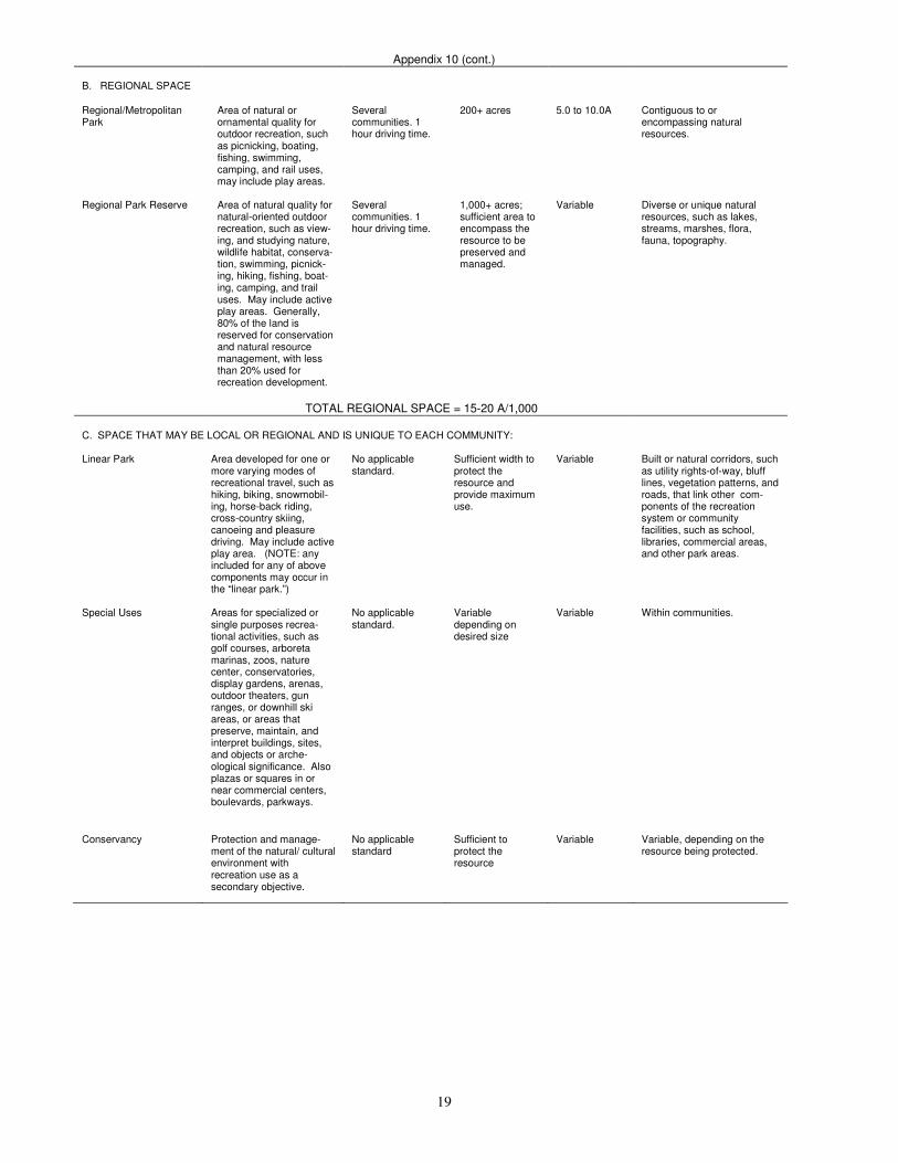
19
Appendix 10 (cont.)
B. REGIONAL SPACE
Regional/Metropolitan Park
Area of natural or ornamental quality for outdoor recreation, such as picnicking, boating, fishing, swimming, camping, and rail uses, may include play areas.
Several communities. 1 hour driving time.
200+ acres 5.0 to 10.0A Contiguous to or encompassing natural resources.
Regional Park Reserve Area of natural quality for
natural-oriented outdoor recreation, such as view-ing, and studying nature, wildlife habitat, conserva-tion, swimming, picnick-ing, hiking, fishing, boat-ing, camping, and trail uses. May include active play areas. Generally, 80% of the land is reserved for conservation and natural resource management, with less than 20% used for recreation development.
Several communities. 1 hour driving time.
1,000+ acres; sufficient area to encompass the resource to be preserved and managed.
Variable Diverse or unique natural resources, such as lakes, streams, marshes, flora, fauna, topography.
TOTAL REGIONAL SPACE = 15-20 A/1,000 C. SPACE THAT MAY BE LOCAL OR REGIONAL AND IS UNIQUE TO EACH COMMUNITY: Linear Park Area developed for one or
more varying modes of recreational travel, such as hiking, biking, snowmobil-ing, horse-back riding, cross-country skiing, canoeing and pleasure driving. May include active play area. (NOTE: any included for any of above components may occur in the “linear park.”)
No applicable standard.
Sufficient width to protect the resource and provide maximum use.
Variable Built or natural corridors, such as utility rights-of-way, bluff lines, vegetation patterns, and roads, that link other com-ponents of the recreation system or community facilities, such as school, libraries, commercial areas, and other park areas.
Special Uses Areas for specialized or
single purposes recrea-tional activities, such as golf courses, arboreta marinas, zoos, nature center, conservatories, display gardens, arenas, outdoor theaters, gun ranges, or downhill ski areas, or areas that preserve, maintain, and interpret buildings, sites, and objects or arche-ological significance. Also plazas or squares in or near commercial centers, boulevards, parkways.
No applicable standard.
Variable depending on desired size
Variable Within communities.
Conservancy Protection and manage-
ment of the natural/ cultural environment with recreation use as a secondary objective.
No applicable standard
Sufficient to protect the resource
Variable Variable, depending on the resource being protected.

20
APPENDIX 11
Sample Recreation Facility Development Standards
Source: Roger A. Lancaster, Ed. 1983. Park & Recreation, Open Space Standards and Guidelines. Alexandria, Virginia: National Recreation and Park Association. Pages 60-61
ACTIVITY FACILITY
RECOMMENDED SPACE REQUIREMENTS
RECOMMENDED SIZE AND DIMENSIONS
RECOMMENDED ORIENTATION
NO. OF UNITS PER POPULATION
SERVICE RADIUS
LOCATION NOTES
Badminton 1620 sq. ft. Singles—17’x44’
Doubles—20’x44’
Long axis north-south
1 per 5000 ¼ - ½ mile Usually in school, recreation center or church facility. Safe walking or bike access.
Basketball
1. Youth
2. High School
3. Collegiate
2400-3036 sq. ft.
5040-7280 sq. ft.
5600-7980 sq. ft.
46-50’x84’
50’x84’
50’x94’
with 5’ unobstructed space on all sides
Long axis north-south
1 per 5000 1/4 -1/2 mile Same as badminton. Outdoor courts in neighborhood and community parks, plus active recreation areas in other park settings.
Handball (3-4 wall)
800 sq. ft. for 4-wall - 1000 sq. ft. for 3-wall
20’ x 40’ – minimum of 10’ to rear of 3 – wall court. Minimum 20’ overhead clearance.
Long axis north-south. Front wall at north end.
1 per 20,000 15-30 minute travel time
4 – wall usually indoor as part of multi-purpose facility. 3 – wall usually outdoor in park or school setting.
Ice Hockey 22,000 sq. ft. including support area.
Rink 85’ x 200’ (minimum 85’ x 185’). Additional 5,000 sq. ft. support area.
Long axis north-south if outdoor
Indoor – 1 per 100,000 Outdoor – depends upon climate
½ - 1 hour travel time
Climate important consideration affecting no. of units. Best as part of multi-purpose facility.
Tennis Minimum of 7,200 sq. ft. single court (2 acres for complex)
36’ x 78’. - 12’ clearance on both sides; 21’ clearance on both sides
Long axis north-south
1 court per 2000 ¼ - ½ mile Best in batteries of 2, Located in neighbor-hood/community park or adjacent to school site.
Volleyball Minimum of 4,000 sq. ft.
30’ x 60’. Minimum 6’ clearance on all sides
Long axis north-south
1 court per 5,000 ½ - ½ mile Same as other court activities (e.g. badminton, basket-ball, etc.).
Baseball 1. Official 2. Little League
3.0-3.85A minimum 1.2A minimum
*Baselines-90’ Pitching distance –- 60 1/2’ Foul lines – min. 320’ Center field – 400’+ *Baselines – 60’ Pitching distance – 46’ Foul lines – 200’ Center field – 200’- 250’
Locate home plate so pitcher throwing across sun and batter not facing it. Line from home plate through pitcher’s mound run east-north-east.
1 per 5000 Lighted – 1 per 30000
¼ - ½ mile
Part of neighborhood complex. Lighted fields part of community complex.
Field Hockey Minimum 1.5A 180’ x 300’ with a minimum of 10’ clearance on all sides
Fall Season – long axis northwest to southeast. For longer periods north to south.
1 per 20,000 15-30 minutes travel
Usually part of baseball, football, soccer complex in community park or adjacent to high school.
Football Minimum 1.5A 16’ x 360’ with a minimum of 6’ clearance on all sides
Same as field hockey
1 per 20,000 15 -30 minutes travel time
Same as field hockey
Soccer 1.7 to 2.1 A 195’ to 225’ x 330’ to 360’ with a 10’ minimum clearance on all sides
Same as field hockey
1 per 10,000 15-30 minutes travel time
Number of units depends on popularity. Youth soccer on fields adjacent to schools or neighborhood parks.
Golf-Driving Range
13.5A for minimum of 25 tees
900’ x 690’ wide. Add 12’ width for each additional tee
Long axis southeast-northeast with golfer driving toward northeast
1 per 50,000 30 minutes travel time
Part of golf course complex. As a separate unit, may be privately operated.
(continued)
21
1/4 –mile running tack
4.3A Overall width – 278’ length – 600.02’ Track with for 8 to 4 lanes is 32’
Long axis in sector from north to south to northwest-south-east with finish line at northerly end.
1 per 20,000 15-30 minutes travel time
Usually part of high school or in community park complex in combination with football, soccer, etc.
Softball 1.5 to 2.0 A Baselines – 60’ Pitching distance – 46’ men. 40’-women Fast pitch field radius from plate – 225’ between foul – lines Slow pitch – 275’ (men) 250’ (women)
Same as baseball 1 per 5,000 (if also used for youth baseball)
¼ - ½ mile Slight difference in dimensions for 188’ slow pitch. May also be used for youth baseball.
Multiple Recreation Court (basketball, tennis, volleyball)
9,840 sq. ft. 120’ x 80’ Long axis of courts with primary use is north-south
1 per 10,000 1-2 miles
Trails N/A Well defined head maximum 10’ width, maximum average grade 5% not to exceed 15%. Capacity rural trails- 40 hikers/day/mile. Urban trails – 90 hikers/day/mile
N/A 1 system per region
N/A
Archery Range Minimum 0.65A 300’ length x minimum 10’ wide between targets. Roped clear space on sides of range minimum of 30’ clear space behind targets minimum 90’ x 45’ with bunker.
Archer facing north + or – 45 degrees
1 per 50,000 30 minute travel time
Part of a regional/metro park complex
Combination Skeet and Trap field (8 stations)
Minimum 30A All walks and structures occur within an area approximately 130’ wide by 116’ deep. Minimum cleared area is contained within two superimposed segments with 100-yard radi (4 acres). Short fall danger zone is con-tained within two super-imposed segments with 300-yard radi (35 acres).
Center line of length runs northeast-south west with shooter facing northeast.
1 per 50,000 30 minutes travel time
Part of regional/ metro park complex.
Golf 1. Par 3 (18 hole) 2. 9-hole standard 3. 18-hole standard
*50 – 60A
*Average length vary 600-2700 yards *Average length – 2250 yards * Average length – 6500 yards
Majority of holes on north-south axis
-- *1 per 25,000 *1 per 50,000
15 to 30 minutes travel time
*9 hole course can accommodate 350 people/day *18 hole course can accommodate 500-550 people/day Course may be located in community or district park, but should not be over 20 miles from population center.
Swimming Pools Varies on size of pool and amenities. Usually ½ to 2A sites
Teaching – minimum of 75’ x45’ even depth of 3 to 4 feet Competitive – minimum of 25m x 16m. minimum of 27 sq ft of water surface per swimmer. Ratios of 2:1 deck vs. water
None – although care must be taken in sitting of lifeguard stations in relation to afternoon sun.
1 per 20,000 (pools should accommodate 3 to 5% of total population at time)
15 to 30 minute travel time
Pools for general community use should be planned for teaching, competitive, and recreational purposes with enough depth (3.4m) to accommodate 1m and 3 m diving boards. Located in community park or school site.
Beach Area N/A Beach areas should have 50 sq ft of land and 50 sq ft of water per user. Turn-over rate is 3. There should be 3-4A supporting land per A of beach.
N/A N/A N/A Should have sand bottom with slope a maximum of 5% (flat preferable). Boating areas completely segregated from swimming area.

22
APPENDIX 12
Part II CHECKLIST ON FACILITY ACCESSIBILITY
Requirements Compliance Status Description Modification
Yes No N/A
6. PICNIC AREAS (Continued)
Location (adjacent to level paths)
C. Trash Receptacles Location (adjacent to level paths) Safety & facility of equipment
D. Picnic Shelters Location (accessible by wide, firm path) Located near accessible water fountains, trash receptacles, restrooms, parking, etc.)
11, Trails A. Surface B. Dimensions C. Rails D. Signage
Part III CHECKLIST ON EMPLOYMENT PRACTICES
Compliance Status Requirements Standards
Yes No N/A Description Modification
5. TESTING Tests and other criterion must measure essential job requirements only.
Tests must be job related and nondiscriminatory towards persons with impaired communications abilities.
6. MEDICAL EXAMINATIONS/ QUESTIONAIRES
Pre-employment medical examinations are permissible only after conditional employment offers.
Medical history questionnaires must not request information as to the nature or severity of an applicant’s handicap.
7. SOCIAL/ RECREATIONAL PROGRAMS
Social/recreational programs sponsored by the recipient must be accessible to handicapped employees.

23
APPENDIX 13
Assessment of Accessibility Needs The following suggestions are in addition to the general improvements noted above, and are presented as a tool to help plan for making the parks more useable. 1. Peterson Park Currently, there is no safe way for persons with disabilities to access the lower level of the park. The
existing road should be opened to allow access to the lower level and parking stalls for the disabled should be installed. This will open up the picnic area to the disabled population. At least one picnic table and grill designed for the disabled should be in place. A pathway constructed out of a stable material could provide a safe path to the ballfield bleacher area. Since most playground equipment is on the western hillside, it might be more cost effective to move certain pieces of the playground equipment to the lower level area and provide a stable pathway to those pieces of equipment.
Currently, the restroom facility is not accessible to the disabled. The major problem is not being able to get to the facility from the parking area without going through grass and down a hill. Recommended accessibility improvements:
- Open access road to lower level. - Designate four disabled parking stalls, including signs and pavement markings (1-lower level, 1-east
parking lot, 1-adjacent to restroom, and 1-main parking lot. - Add or modify one picnic table and one grill on lower level to meet ADA requirements. - Construct a stable pathway from lower level parking area to picnic/play area and the ballfield bleacher
area. - Purchase any new playground equipment with the disabled population in mind. - Modify the area of blacktop directly adjacent to the restroom/concession stand facility to accommodate
one disabled parking stall, allowing direct access to the facility. A small ramp is also needed to compensate for about a two-inch change in surface height at the facility entrances, and the concession counter should be lowered to no higher than 34 inches in at least a 30 inch section of the opening to accommodate wheelchair customers.
- Modify the interior of the restroom facility to comply with exact specifications of ADA.

24
APPENDIX 14
Mount Horeb Capital Improvement Plans
PARK RECOMMENDED COST YEAR
Boeck’s Park
Slide and Access 55,000 1993
Bathhouse 300,000 1995
Additional Playground Equipment 5,000 1994
Site landscaping 5,000 1994
Install Additional Barrier Free Picnic Tables and Grills 600 1994
Construct Additional Parking Area 15,000 1996
Additional Landscaping 5,000 1997
Total $385,600
Foster Park
Upgrade Playground Area 5,500 1993
Install Path System in Park to Connect Facilities 2,000 1994
Total $7,500
Garfield Park No Improvements Planned
Grundahl Park
ADA Compliance 2,000 1993
Install Additional Barrier Free Tables and Grills 600 1993
Basketball Court 5,000 1993
Landscaping 1,000 1994
Total $8,600
Howard Himsel Park
Prepare Park Master Plan 2,200 1994
Total $2,200
Jaycee Park No Improvements Planned
Lions Park
Additional Playground Equipment 5,000 1994
Install Small Shelter 5,000 1995
Install Sand Volleyball Court 1,200 1996
Total $11,200
Nesheim Park No Improvements Planned
Waltz Park
Pathways 5,000 1993
Additional Playground Equipment 10,000 1994
Additional Trees 2,000 1994
Install Additional Trees 2,000 1994
Install Sand Volleyball Courts/Basketball Court 5,000 1995
Install Restroom and Water Facilities/Small Shelter 50,000 1996
Small Shelter 20,000 1997
Total $94,000
General Park Facility Improvements
ADA Compliance (1st year) 2,000 1993
ADA Compliance (2nd
year) 2,000 1994
Recreation Director Office 10,000 1995
Total $14,000
New Soccer/Softball Facility Total $100,000 1997
Grand Total $609,100


![UNIVERSITAS PADJADJARAN INDONESIA – TEAM 11 · PDF fileUNIVERSITAS PADJADJARAN INDONESIA – TEAM 11 ... Bowater v. Rowley Regis Corp. [1944] KB 476 (CA ... Kuwait Airways Corp v](https://static.fdocuments.in/doc/165x107/5a9db6b27f8b9abd0a8c4163/universitas-padjadjaran-indonesia-team-11-padjadjaran-indonesia-team.jpg)