Ahearn Avenue Proposed Sidewalk Project - documents.ottawa.ca
INTRO
DU
CTIO
NTH
E AREA
TOD
AYTH
E PLAN
IMPLEM
ENTATIO
NCO
NTEXT FO
R CHA
NG
E
1
1.0INTRODUCTION
2.0CONTEXT FOR CHANGE
3.0THE AREA TODAY
4.0THE PLAN
5.0IMPLEMENTATION
1 IntroductionOttawa is a growing, evolving city. This is no more evident than west of downtown, where the City is building the first phase of the Confederation Light Rail Transit (LRT) to Tunney’s Pasture. The surrounding neighbourhoods of Mechanicsville, Hintonburg, Wellington Village and Champlain Park are changing, and Wellington Street West is bustling. The character of the neighbourhoods, their central location and their proximity to rapid transit make them very desirable places to live. The area is experiencing growth pressures, with developers planning new housing at various scales. As part of an overall plan to grow Ottawa more sustainably, the City encourages growth within the designated Mixed-Use Centre that includes Tunney’s Pasture and adjacent areas.
This Community Design Plan (CDP) has been prepared to guide future change in the area surrounding the Tunney’s Pasture Transit Station, an area that takes its name from the transportation corridor that connects thefour established and evolving neighbourhoods. It is intended to guide not only private development but also important public initiatives that will improve the area and support intensification.

INTRO
DU
CTIO
NTH
E AREA
TOD
AYTH
E PLAN
IMPLEM
ENTATIO
NCO
NTEXT FO
R CHA
NG
E
2
Scott
Burnside
Ladouceur
Bullman
Bullman
Parc
Laroche Park
Remic
Rapids
Lyndale
Sorrel
Sir Jo
hn A. M
acdonald
Eglantine
Sunnymede
Premier
Yarrow
Tunney’s PasturePré Tunney
Bayview
Garland
Hilda
Goldenrod
Sir Frederick BantingNorthw
esternCowley
Spencer
Armstrong
Wellington
Parkdale
Pinehurst
Hinchey
Carruthers
Stirling
Parkdale
Forward
Hinchey
Carruthers
Stonehurst
Pinhey
Merton
Holland
Hamilton
Huron
CarolineSmirleGrangeRossGilchristW
esternCarleton
Colombine
NORTH HINTONBURG
WELLINGTONVILLAGE
TUNNEY`S PASTURE
BAYVIEW
Provincial HighwayAutoroute provinciale
Federally Owned RoadRoute fédérale
ArterialArtère
Major CollectorGrande collectrice
CollectorRoute collectrice
Potential Collector onTunney`s Pasture(Conceptual)Route collectrice possible (conceptuelle)
Potential Federally Owned RoadRoute locale possible
Potential Local Street onTunney`s Pasture(Conceptual)au pré Tunney (conceptuelle)
Future Local StreetRue locale future
Right-of-Way Protection Priority(26m)Protection de l’emprise (26 m)
Signalized IntersectionCarrefour avec feux de circulation
Proposed Number of Car LanesNombre de voies pour les voitures proposées
LRT StationStation du TLR
Bayview Station CDPDu Secteur do la station Bayview
Provincial HighwayAutoroute provinciale
Federally Owned RoadRoute fédérale
ArterialArtère
Major CollectorImportante route collectrice
CollectorRoute collectrice
Right-of-Way Protection Priority(26m)Protection de l’emprise (26 m)
Existing Signalized IntersectionCarrefour avec feux de circulation actuel
Transitway StationStation du Transitway
CDP Study Area
CDP Area BoundaryLimite du PCC
CDP Focus AreaSecteur d’intérêt du PCC
General Urban AreaZone urbaine générale
Central AreaZone centrale
Mixed Use Centre Centre d’utilisations polyvalentes
Major Open SpaceEspaces verts d’importance
Urban Natural FeaturesCaractéristiques naturelles de zone urbaine
Traditional Main StreetRue principale traditionnelle
Existing Multi-use PathwaySentier polyvalent existant
Proposed Multi-use PathwaySentier polyvalent proposé
Future Pedestrian Pathway Sentier piétonnier futur
Future PathwaySentier futur
Enhanced Community PathwaySentier communautaire amélioré
Existing PathwaySentier existant
Enhanced Cross WalkPassage pour piétons amélioré
Signalized IntersectionCarrefour avec feux de circulation
Future LRT StationStation du TLR future
Bayview Station CDPDu Secteur do la station Bayview
Existing Multi-use PathwaySentier polyvalent existant
Proposed Multi-use PathwaySentier polyvalent proposé
Future Cycle Track (O�-Road)Voie cyclable future (hors rue)
Future Bike Lane (On-Road)Voie cyclable future (sur rue)
Future Shared Use Lane (Signed Route)Future voie partagée (tracé balisé)
Enhanced Cross WalkPassage pour piétons amélioré
Signalized IntersectionCarrefour avec feux de circulation
Future LRT StationStation du Transitway
Bayview Station CDPDu Secteur do la station Bayview
Existing Multi-use PathwaySentier polyvalent existant
Existing O�-Street Multi-use PathwaySentier polyvalent hors rue existant
Existing PathwaySentier existant
Existing Signalized IntersectionCarrefour avec feux de circulation actuel
BRT StationStation de transport en commun rapide par autobus (TCRA)
LRT Station
LRT Line
Existing Bus Route
Existing O-train/Planned LRT Line
LRT Station Plaza
LRT Station
BRT
Planned LRT Line
Bus Route (Based on Existing)
Existing O-train/Planned LRT Line
Interim Transfer Bus Station
Interim Bus Parking
BRT Station
BRT
Existing Bus Route
Existing O-train/Planned LRT Line
Residential-High Pro�leUtilisation résidentielle à pro�l élevé
Residential-Medium Pro�leUtilisation résidentielle à pro�l moyen
Residential-Low Pro�leUtilisation résidentielle à pro�l bas
CommercialCommerciale
O�ceBureau
InstitutionalInstitutionnelle
IndustrialIndustrielle
UtilityServices publics
Open Space and ParksEspace ouvert et parcs
Low-Pro�le Residential BuildingMedium-Pro�le Residential BuildingHigh-Pro�le Residential BuildingResidential Mixed-Use BuildingO�ce BuildingRetail Space BuildingPublic/Institutional Building
Low-Rise Neighbourhood
Tunneys Pasture Mixed-Use CentreSubject to Tunneys Pasture Master Plan
Holland-Parkdale NodeMixed-Use Centre
Secondary Mainstreet
Active Frontage
NCC
Existing/Proposed Open Space
Existing/Proposed Plaza
Community Centre/Facility
LRT Station
CDP Study Area
BRT Station/Planned LRT StationStation de transport en commun rapide par autobus (TCRA)/station du TLR plani�é
BRT Line/ Planned LRT LineLigne de transport en commun rapide par autobus/ ligne de TLR prévue
Existing Bus Route Circuit d’autobus existant
Existing O-train/Planned LRT LineTracé actuel de l’O-Train/ligne du TLR prévue
Planned LRT Station PlazaPlace de la station du TLR prévue
Bayview Station CDPDu Secteur do la station Bayview
Existing Multi-use PathwaySentier polyvalent existant
Existing O�-Street Multi-use PathwaySentier polyvalent hors rue existant
Existing Bike Lane (On-Road)Voie cyclable actuelle (sur rue)
Existing Shared Use LaneVoie partagée actuelle
Existing Signalized IntersectionCarrefour avec feux de circulation actuel
Transitway StationStation du Transitway
ApprovedApprouvées
Under ReviewEn examen
Under Construction/Recently CompletedEn construction/Achevé récemment
CDP AreasSecteurs des PCC
Scott St. CDP Study AreaSecteur à l’étude du PCC de la rue Scott
Height Limits Subject toTunney`s Pasture Master Plan
Low Pro�leUp to 11mUp to 14.5 m (4 Storeys ) Up to 14.5 m (4 Storeys ) *Except Where Angular Premits Greater Height-See Guidelines Section 4.2.2(C)
Medium Pro�leUp to 19 m (6 Storeys)
High Pro�le Up to 76m (25 Storeys)Up to 55m (18 Storeys)Up to 37m (12 Storeys)
Maximum Height Subjuct to Angular Plane and CDP Tall-Building Guidelines
Height Limits Varies as Per Existing Zoning
General Location for Tall Building*Subject to CDP Tall-Building Guidelines
Neighbourhood Line
LRT Station
CDP Study Area
Transit Plaza
Parkdale Greenway
Sir Frederick Banting Greenway
Columbine Cycling Route
Transitway Greenway
Neighbourhood Park and Community Centre
T
1
2
3
4
5
6
Mixed-Use CentreCentre d’utilisations polyvalentes
Secondary MainstreetRue principale résidentielle
Low-Rise Residential Secteur résidentiel de faible hauteur
Low-Rise Residential (Max 6 Storeys)Secteur résidentiel de faible hauteur (6 étages)
Apartment NeighbourhoodQuartier d’immeubles de logements
Local CommercialLocal commercial
Public/Institutional AreaSecteur public/institutionnel
Open SpaceEspace ouvert
Mid Block Connection Lien à mi pâté
Mid Block Connection-ConceptualLien à mi pâté-Conceptuel
Tunney`s Pasture Open SpaceEspace ouvert pré Tunney
Capital FunctionFunction de la Capital
NCC Open SpaceEspace vert de la CCN
Subject to NCC Urban Land MasterplanSous reserve de l'achèvement du Plan directeur des terrains urbains de la capitale
UtilityServices publics
Potential Community Centre/ FacilityCentre/installations communautaires potentiels
LRT StationStation du TLR
Neighbourhood LineLigne de quartier
CDP Study AreaSecteur d’étude du PCC
**
CDP STUDY AREA
1.1 The Study Area
The original study area for the Scott Street CDP stretched from Northwestern Avenue in the west to Bayview Road in the east, along Scott Street, and from the north edge of Tunney’s Pasture to almost Wellington Street West in the south. The area captures Tunney’s Pasture, the Mechanicsville neighbourhood and portions of the Hintonburg Champlain Park and Wellington Village neighbourhoods. Through the course of the study, it became apparent that the southern boundary of the area should be extended to the edge of the West Wellington Street CDP area, to recognize larger portions of Hintonburg and Wellington Village, where significant change is not planned. In addition, the northern boundary was modified to capture public lands, including Laroche Park and the National Capital Commission (NCC) property north of Burnside Avenue, that are effectively part of Mechanicsville.
Centred approximately on the Tunney’s Pasture Transit Station, the CDP area captures a population of residents and workers who are generally within a 10-minute walk of the station (residents in the east end of the study area are also a short walk from the Bayview Station).
Within the modified CDP boundary is an area identified through the study process where physical improvements are most desirable and hence will be the focus for the CDP.
INTRO
DU
CTIO
NTH
E AREA
TOD
AYTH
E PLAN
IMPLEM
ENTATIO
NCO
NTEXT FO
R CHA
NG
E
3
1.2 What is aCommunity DesignPlan?Community Design Plans are intended to guide change in areas of Ottawa targeted for growth and improvement, including the Central Area, Town Centres, Mixed-Use Centres, Developing Communities and Mainstreets. Their purpose is to translate the principles and policies of the City’s Official Plan to the community scale. CDPs recognize that each community is unique and has distinct opportunities and challenges for managing change.
CDPs are often initiated in response to pressures for change or growth in an area and are intended to provide the opportunityfor early involvement and discussion by all parties about how future development should occur. In the spirit of collaborative community building, they are prepared through an open and public process.
CDPs focus on land use and development but also address transportation and elements of the public realm, including parks and streetscapes. They may produce related initiatives such as design guidelines, zoning amendments, a greening strategy or any number of other strategies that are required to address the physical development of the study area. CDPs are approved by City Council and may be implemented through a Secondary Plan.
1.3 How to use this CDP
The Scott Street CDP is intended to be used by organizations and individuals who will play a role in shaping future development in the area, including City departments, City Council, federal agencies, landowners, business owners, community associations and residents. Specifically, it should be used as follows:
• To inform landowners, business owners, developers and the general public about the urban design vision and objectives for the area;
• As the basis for a Secondary Plan setting out policies respecting land use, built form, the public realm and other matters;
• As the basis for amendments to the City’s Zoning By-law;
• To inform the planning and development of federal lands within the area, namely Tunney’s Pasture and lands managedby the NCC;
• To guide detailed planning of public capital projects identified in the plan and updates to the City’s plan for capital projects;
• As a guideline document when preparing and reviewing site-specific rezoning, site plan and Committee of Adjustment applications as well as capital projects.
As a multi-faceted guideline document, this CDP builds upon previous plans for the area and complements other general design guidelines prepared by the City and which may be applied to the area. Where the CDP conflicts with previously adopted guidelines, the guidelines in this document shall prevail.

2013
INTRO
DU
CTIO
NTH
E AREA
TOD
AYTH
E PLAN
IMPLEM
ENTATIO
NCO
NTEXT FO
R CHA
NG
E
4
2014
1.4 Study Process
The Scott Street CDP Study began in February 2013 and followed a four-phase process over a 10-month period. Community representatives, landowners, and other key stakeholders were interviewed early in the process for their perspectives on the issues and opportunities in the area. A Public Advisory Committee (PAC), comprised of representatives from each of the affected neighbourhoods and the Wellington West Business Improvement Association (BIA), was formed to provide a sounding board as directions for the CDP emerged. Public consultation events provided an opportunity in each phase of the project for residents, business owners, land owners
and other stakeholders to provide input and feedback. These included community workshops held May 1st and 2nd and June 26th and community meetings held October 9th and November 13th.A Technical Advisory Committee (TAC) comprised of staff from various City departments, OC Transpo, the NCC, and Public Works and Government Services Canada (PWGSC) also provided critical input and feedback at project milestones. In addition, the team consulted regularly with individual agencies to ensure the CDP was informed by and coordinated with other ongoing initiatives, and vice versa.
PHASE 1Goals, Objectives and Potential
• mapping, modeling & analysis• stakeholder interviews• visioning workshops
Feb-May
PHASE 2Vision and Urban Design
Framework
• preliminary directions• conceptual framework• PAC meeting• community meeting (June 26)• confirm framework
May-July
PHASE 3Draft CDP
• recommended directions• PAC meeting• community meeting (Oct 9)• complete draft CDP
July-Oct
PHASE 4Final CDP
• refine document• community meeting (Nov 13)• finalize CDP• presentation to Planning
Committee
Nov-Dec

INTRO
DU
CTIO
NTH
E AREA
TOD
AYTH
E PLAN
IMPLEM
ENTATIO
NCO
NTEXT FO
R CHA
NG
E
5 MAY 2, 2013 OPEN HOUSE
1.5 What We Heard
Active participation by residents living in and around the Scott Street area was critical to developing a design plan that reflects both the community’s vision and the City’s Official Plan. Residents had the opportunity to provide input and feedback verbally and through comment sheets at a visioning workshop held in May 2013 and well-attended community meetings held in June, October and November that year. In total, more than 300 residents participated in the process.The sampling of comments captured here reflect the concerns and aspirations expressed by the community early in the study process.
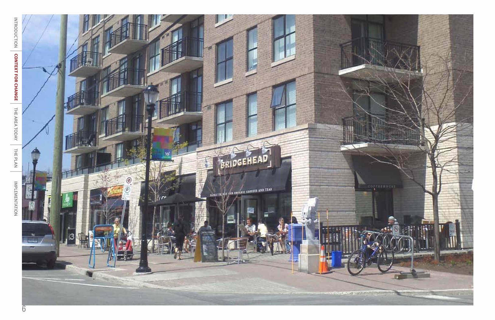
We understand our community is going to change, but don’t wreckthe neighbourhoods we love them they way they are! Scott Street isa very unfriendly street for pedestrians and cyclists Tunney’s Pasture isnot an inviting place Does density have to mean a lot of tall buildings?The eclectic character and mix of uses in Mechanicsville should bemaintained If intensification is going to happen, the entire communityshould benefit Laroche Park is heavily used and needs better facilities It’s not easy or pleasant to walk to the transit stations We need moreretail amenities like a small grocery store Once the LRT is built, reducethe width of Scott Street and remove all the buses We need more green space Height transitions should happen in the mixed-use centre, not inthe neighbourhoods Carruthers is a key place for crossing Scott Street,especially for kids going to schools—it should feel safer Why can’t theNCC lands be more accessible? Housing in the area is becoming less and less affordable There is no clarity on the rules for development todayTraffic on Parkdale is terrible and cut-through traffic is getting worse—more density will mean more traffic Bike lanes on Holland was a missed opportunity Make sure the area stays family-friendly Don’t repeat the30-storey buildings on Parkdale Don’t count on development happening in Tunney’s Pasture for a long time The greenway on Scott Street should be on the south side of the road to provide a buffer New developmentshould be designed for people who walk, bike and take transit The zoning in the neighbourhoods today is working We need better walking andcycling connections to the river Don’t build for cars, build for people.
CON
TEXT FO
R CHA
NG
E
6
INTRO
DU
CTIO
NTH
E AREA
TOD
AYTH
E PLAN
IMPLEM
ENTATIO
N