CONSTRUCTION BEST MANAGEMENT PRACTICES PLAN (CBMPP)
58
CONSTRUCTION BEST MANAGEMENT PRACTICES PLAN (CBMPP) Prepared for: South Alabama Airport Stabilization East end of the South Alabama Regional Airport Andalusia, AL 36421 Phone: (334) 222-6598 Operator: Carter’s Contracting Services, Inc. Mertha Carter, President 32363 Harmony Church Road Andalusia, AL 36421 334-222-6670 CBMPP Contact(s)/QCP Goodwyn, Mills and Cawood, Inc. Gary Brown, CPESC P.O. Box 242128 2660 EastChase Lane, Suite 200 Montgomery, Alabama 36117 Tel: 334-271-3200 Fax: 334-272-1566 CBMPP Preparation Date 06/20/2014 Estimated Project Dates: Project Start Date: 08/18/2014 Project Completion Date: 02/18/2015
Transcript of CONSTRUCTION BEST MANAGEMENT PRACTICES PLAN (CBMPP)

CONSTRUCTION BEST MANAGEMENT PRACTICES PLAN (CBMPP)
Prepared for:
South Alabama Airport Stabilization
East end of the South Alabama Regional Airport
Andalusia, AL 36421
Phone: (334) 222-6598
Operator:
Carter’s Contracting Services, Inc.
Mertha Carter, President
32363 Harmony Church Road
Andalusia, AL 36421
334-222-6670
CBMPP Contact(s)/QCP
Goodwyn, Mills and Cawood, Inc.
Gary Brown, CPESC
P.O. Box 242128
2660 EastChase Lane, Suite 200
Montgomery, Alabama 36117
Tel: 334-271-3200
Fax: 334-272-1566
CBMPP Preparation Date
06/20/2014
Estimated Project Dates:
Project Start Date: 08/18/2014
Project Completion Date: 02/18/2015
CONSTRUCTION BEST MANAGEMENT PRACTICES PLAN June 2014
South Alabama Airport Stabilization
ii
TABLE OF CONTENTS 1.) Site Evaluation, Assessment, and Planning ................................................................................................... 1
1.1) Project/Site Information ....................................................................................................................... 1
1.2) Contact Information/Responsible Parties ......................................................................................... 2
1.3) Nature and Sequence of Construction Activity................................................................................. 3
1.4) Soils, Slopes, Vegetation, and Current Drainage Patterns ............................................................... 4
1.5) Pre- and Post- Construction Site Estimates ........................................................................................ 6
1.6) Receiving Waters ................................................................................................................................... 6
1.7) Site Features and Sensitive Areas to be Protected............................................................................. 6
1.8) Potential Sources of Pollution .............................................................................................................. 6
1.9) Endangered Species .............................................................................................................................. 6
1.10) Historic Preservation ............................................................................................................................ 7
1.11) Applicable Federal, State, or Local Programs .................................................................................... 7
1.12) Maps ........................................................................................................................................................ 7
2.) Erosion and Sediment Control BMPs .............................................................................................................. 7 2.1) Minimize Disturbed Area..................................................................................................................... 7
2.2) Phase Construction Activity ................................................................................................................ 7
2.3) Control Stormwater Flowing onto and through the Project ............................................................ 8
2.4) Stabilize Soils ......................................................................................................................................... 8
2.5) Protect Slopes ......................................................................................................................................... 9
2.6) Establish Perimeter Controls and Sediment Barriers ....................................................................... 9
2.7) Retain Sediment On-Site ..................................................................................................................... 10
2.8) Establish Stabilized Construction Exit Pads .................................................................................... 10
2.9) Additional BMPs ................................................................................................................................. 10
3.) Good housekeeping BMPs .............................................................................................................................. 11
3.1) Material Handling and Waste Management ................................................................................................ 11
3.2) Establish Proper Building Material Staging Areas ......................................................................... 11
3.3) Designate Washout Areas .................................................................................................................. 11
3.4) Establish Proper Equipment/Vehicle Fueling and Maintenance Practices ................................. 11
3.5) Control Equipment/Vehicle Washing .............................................................................................. 12
3.6) Spill Prevention and Control Plan..................................................................................................... 12
3.7) Any Additional BMPs ......................................................................................................................... 12
3.8) Non-Stormwater Discharge Management ....................................................................................... 12
4.) Selecting Post Construction BMPs ................................................................................................................. 13
5.) Inspections .......................................................................................................................................................... 13
5.1) Inspections ............................................................................................................................................ 13
5.2) Delegation of Authority...................................................................................................................... 14
5.3) Corrective Action Log ......................................................................................................................... 14
6.) Record Keeping and Training ......................................................................................................................... 14
6.1) Record Keeping ................................................................................................................................... 14
6.2) Log of Changes to the CBMPP .......................................................................................................... 14
6.3) Training (Optional) ............................................................................................................................. 15
7.) Final Stabilization ............................................................................................................................................. 15
8.) Turbidity Requirements .................................................................................................................................. 15
9.) Certification Notification ................................................................................................................................. 16

CONSTRUCTION BEST MANAGEMENT PRACTICES PLAN June 2014
South Alabama Airport Stabilization
iii
APPENDICES APPENDIX A General Location Map
APPENDIX B Site Maps and BMP Details
APPENDIX C NOI and Approval Letter from ADEM
APPENDIX D Inspection Reports
APPENDIX E Corrective Actions Log
APPENDIX F CBMPP Amendment Log
APPENDIX G Grading and Stabilization Activities
APPENDIX H Training Log (Optional)
APPENDIX I Delegation of Authority
APPENDIX J Additional Information

CONSTRUCTION BEST MANAGEMENT PRACTICES PLAN June 2014
South Alabama Airport Stabilization
1
1.) Site Evaluation, Assessment, and Planning
1.1) Project/Site Information
Project/Site Name: South Alabama Airport Stabilization
Project/Street Location: East end of the South Alabama Regional Airport
City: Andalusia State: AL Zip Code: 36421
County: Covington County
Latitude/Longitude of Facility
Latitude: Longitude:
N31.307878 W86.381259
Method for determining latitude/longitude:
� USGS Topographic Map: Andalusia, AL � EPA Website � GPS
Scale – 1-24,000
� Other:

CONSTRUCTION BEST MANAGEMENT PRACTICES PLAN June 2014
South Alabama Airport Stabilization
2
1.2) Contact Information/Responsible Parties
Operator:
Carter’s Contracting Service, Inc.
Mertha Carter, President
32363 Harmony Church Road
Andalusia, AL 36421
Phone: 334-222-6670
Project Manager(s) or Site Supervisor(s)
Carter’s Contracting Service, Inc.
Mertha Carter, President
32363 Harmony Church Road
Andalusia, AL 36421
Phone: 334-222-6670
CBMPP Contact(s)/QCP
Goodwyn, Mills and Cawood, Inc.
Gary Brown, CPESC
2660 EastChase Lane, Suite 200
Montgomery, AL 36117
Phone: 334-271-3200
Email: [email protected]
QCI or Qualified Person(s):
Goodwyn, Mills and Cawood
Case O’Dell
2660 EastChase Lane, Suite 200
Montgomery, AL 36117
Phone: 334-271-3200
Email: [email protected]
This CBMPP was Prepared By:
Goodwyn, Mills and Cawood, Inc.
Gary Brown, CPESC
2660 EastChase Lane, Suite 200
Montgomery, AL 36117
Phone: 334-271-3200
Email: [email protected]

CONSTRUCTION BEST MANAGEMENT PRACTICES PLAN June 2014
South Alabama Airport Stabilization
3
Emergency 24-Hour Contact:
Carter’s Contracting Service, Inc.
Mertha Carter, President
32363 Harmony Church Road
Andalusia, AL 36421
Phone: 334-222-6670
For Large Spills Contact: 1-800-843-0699
Addition Contact Numbers can be found at: www.adem.state.al.us/moreinfo/emergencyresponse.cnt
1.3) Nature and Sequence of Construction Activity
General Scope:
The project is located in Andalusia, Covington County, Alabama in Township 4 North, Range 17 East,
Sections 19 & 20. The site is approximately 46.62 acres in size with 46.62 acres being disturbed.
Disturbance activities will consist of grading and stabilzation of bare soils.
Proposed Activity to be Conducted:
� Residential �Commercial � Industrial � Road Construction � Linear Utility
� Other: Site Stabilization
If Non-Coal, Non-Metallic Mining, Recovery, or Construction Material Management Site:
� Dirt-Chert � Sand-Gravel � Shale-Clay � Crushed-Dimension Stone � Other:
Primary SIC Code: 1794
Primary NAICS Code: 238910
Project Description: Construction activities will result in improvements to an existing softball
complex.
Project Start Date: 08/18/2014
Project Completion Date: 02/18/2015

CONSTRUCTION BEST MANAGEMENT PRACTICES PLAN June 2014
South Alabama Airport Stabilization
4
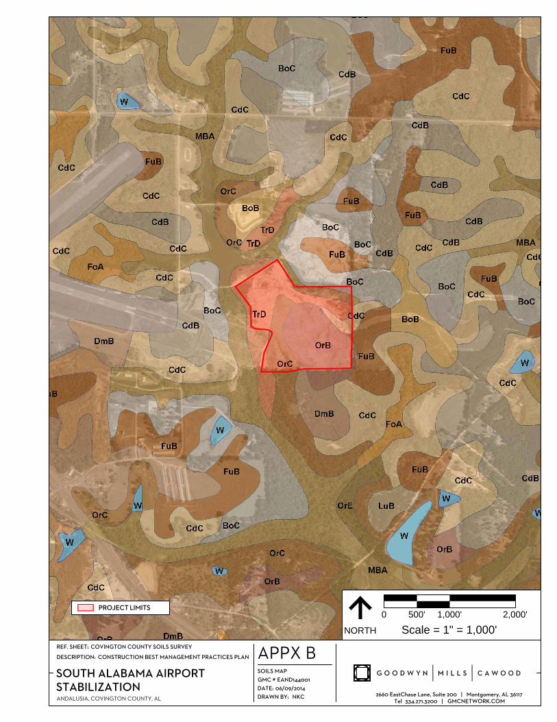
1.4) Soils, Slopes, Vegetation, and Current Drainage Patterns
Soils:
According to the Covington County Soils Survey1, seven (7) soil types are found within the potential
disturbance areas of the subject site. Below are descriptions of the soil types:
Bonifay loamy fine sand, 5 to 10 percent slopes, (BoC)
This soil unit ranges from a brown loamy fine sand to a light yellowish brown loamy fine sand. It is
deep, well drained, and moderately sloping. It is found on short, winding side slopes on uplands in
the Coastal Plain. Slopes are smooth and convex. This unit’s permeability is rapid in the surface layer,
moderate in the upper part of the subsoil, and moderately slow in the lower part. This type of soil is
strongly acid or very strongly acid except where lime has been added with a low amount of organic
matter present. It is poorly suited for cultivated crops but fairly suited for hay and pasture.
Cowarts-Dothan complex, 5 to 10 percent slopes, (CdC)
This complex consists of areas of Cowarts and Dothan soils on very narrow, sloping ridge tops and
side slopes on uplands of the Coastal Plain. These soils are deep and well drained. Areas of the
Cowarts and Dothan soils are too intricately mixed on the landscape or too small to be mapped
separately. In some areas, soil texture, thickness of the surface layer, and depth of the subsoil are
extremely variable and change considerably over short distances. Slopes are short and very complex.
Typically, the Cowarts ranges from brown loamy sand to mottled reddish yellow, light brownish gray,
light yellowish brown, yellowish red, and yellowish brown sandy clay. Typically, the Dothan soils
range from dark grayish brown sandy loam to mottled yellowish brown, strong brown, red, light gray,
and yellowish red sandy clay loam. This intricate type of soil is moderately permeable with low water
capacity and is strongly acid or very strongly acid except where lime has been added. These soils are
well suited to grasses and legumes for hay and pasture.
Fuquay loamy fine sand, 0 to 5 percent, (FuB)
This soil is deep and well drained. It is on nearly level and gently sloping ridge tops, side slopes, and
benches on uplands of the Coastal Plain. Slopes are smooth and convex. This soil ranges from dark
grayish brown loamy fine sand to mottled red, light gray, yellowish brown, strong brown, and pale
brown sandy clay loam. This mapping unit’s permeability is listed as rapid in the surface and
subsurface layers, moderate in the upper part of the subsoil, and slow in the lower part with low water
capacity and is strongly acid or very strongly acid except where lime has been added. This soils is well
suited for grasses and legumes for hay and pasture, and it is also well suited for the growth of loblolly
pine.
1. Covington County Soil Survey, Web Soil Survey, United States Department of Agriculture Soil Conservation
Service.

CONSTRUCTION BEST MANAGEMENT PRACTICES PLAN June 2014
South Alabama Airport Stabilization
5
Muckalee, Bibb, and Osier soils, 0 to 2 percent slopes, frequently flooded, (MBA)
These Muckalee, Bibb, and Osier soils are deep and poorly drained. They are on nearly level or gently
undulating flood plains. They are subject to frequent flooding of brief duration, mainly late in winter
and in spring. Slopes are smooth and slightly concave except where they are cut with old stream
channels. Each soil is in areas large enough to be mapped separately, but were not because of the
present and expected use of these soils. Most mapped areas have each soil, but the areas in the
southwest and south-central parts of the county do not have Muckalee soil. Bibb and Osier soils are
the major soils in the map unit. The Muckalee is usually gray sandy loam with pale brown mottles.
The Bibb soil ranges from dark gray loam to undecomposed hardwood leaves, twigs, and fine roots, to
a light gray sand. The Osier ranges from stratified, very pale brown sand and brownish yellow sandy
loam down to a light gray sand. All of these soil types have a low to moderate water capacity and are
very strongly acid or extremely acid. These soils are not suited for hay and pasture because of the
frequent flooding. Loblolly pines, sweet gum, and water oak trees are all grown.
Orangeburg sandy loam, 1 to 5 percent slopes, (OrB)
This soil is deep and well drained. It is on nearly level and gently sloping ridge tops on uplands of the
Coastal Plain. Slopes are complex and convex. Typically, this unit ranges from brown sandy loam on
the surface to dark red sandy loam. This soil has a moderate permeability with moderate water
capacity and is strongly acid or very strongly acid except where lime has been added. This
Orangeburg soil is used mostly as cropland.
Orangeburg sandy loam, 5 to 8 percent lopes, (OrC)
This soil is deep and well drained. It is on sloping ridge tops and side slopes on uplands of the Coastal
Plain. Slopes are complex and convex. It ranges from a brown sandy loam surface layer to dark red
sandy loam bottom. This mapping unit is moderately permeable with moderate water capacity and is
strongly acid or very strongly acid except where lime has been added. This Orangeburg soil is used
mostly as cropland.
Troup loamy sand, 5 to 15 percent slopes, (TrD)
This soil is deep and well drained. It is on narrow, moderately sloping or moderately steep side slopes
on uplands of the Coastal Plain. Slopes are complex and convex. It ranges from a brown loamy sandy
surface to yellowish red find sandy loam and yellowish red sandy clay loam subsoil. This soil’s
permeability is rapid in the surface and subsurface layers and moderate in the subsoil with a very low
water capacity and is strongly acid or very strongly acid except where lime has been added. This soil
is not suited to cultivated crops and is fairly suited to grasses and legumes for hay and pasture.
The Muckalee, Bibb, and Osier soils are all listed as hydric soils on the Covington County Hydric soils
list (2005). A hydric soil is one that is saturated, flooded, or ponded long enough during the growing
season to develop anaerobic conditions in the upper horizons.
CONSTRUCTION BEST MANAGEMENT PRACTICES PLAN June 2014
South Alabama Airport Stabilization
6
Slopes: There are no significant slopes located on site.
Vegetation: Denude
Drainage Patterns: The overall drainage patterns of the site will not be altered by the construction
and can be found on the USGS Topographic map in Appendix B.
1.5) Pre- and Post- Construction Site Estimates
The following are estimates of the construction site.
Total project area: 46.62 ac.
Construction site are to be disturbed: 46.62 ac.
Percentage impervious area before construction: 0 %
Percentage impervious area after construction: 0 %
1.6) Receiving Waters
The receiving water for discharges from this project is an unnamed tributary to Hollis Creek. Upon
review it is determined that this project does not discharge into a Priority Water for construction sites.
1.7) Site Features and Sensitive Areas to be Protected
There are no site features or sensitive areas to be protected at this time.
1.8) Potential Sources of Pollution
The main source of potential pollution for this project is sediment due to grading operations. Multiple
BMPs including a staging area including a construction exit pad, silt fence, erosion control matting,
seeding, and mulching implemented to minimize erosion and prevent sediment from leaving the site.
Existing rock check dams and earthen berms will be used to control stormwater flowing through the
site and will be installed as described in section 2.3. The silt fence will be used as a perimeter control
and sediment barrier as outlined in section 2.6. Seeding and mulching of graded areas to prevent rill
and gully erosion and aide in the establishment of permanent vegetation will be implemented as
outlined in 2.4. All BMPs used to reduce the potential for pollution should be inspected weekly and
after each significant storm (3/4 inch in 24 hour). Any required repairs shall be made immediately
(within five (5) days).
1.9) Endangered Species
Are endangered or threatened species and critical habitats on or near the project area?
� Yes � No
If yes, ADEM strongly recommends that the site operator work closely with the appropriate field
office of the U.S. Fish and Wildlife Service www.fws.gov/southeast/es [Montgomery, AL (334) 285-

CONSTRUCTION BEST MANAGEMENT PRACTICES PLAN June 2014
South Alabama Airport Stabilization
7
9600; and Daphne, AL (251) 441-5181] and the Alabama Department of Conservation and Natural
Resources Wildlife & Freshwater Fisheries [(334) 242-3465].
1.10) Historic Preservation
Are there any historic sites on or near the construction site?
� Yes � No
If yes, ADEM strongly recommends that the site operator work closely with the Alabama Historical
Commission’s Historic Preservation Office [(334) 230-2667]
1.11) Applicable Federal, State, or Local Programs
At this time there are no known other federal, state, or local programs required for this project.
1.12) Maps
Maps of the site are located in Appendices A and B. These maps include a general location map, a
USGS topographic map, a soils map, an aerial map, and a site plan map indicating the locations of all
erosion and sediment control BMPs to be implemented on site.
2.) Erosion and Sediment Control BMPs Refer to the site maps found in Appendix B for the locations where erosion and sediment control
BMPs are to be installed.
2.1) Minimize Disturbed Area
The entire site has been previously disturbed. Additional areas should not be disturbed to minimize
the amount of overall disturbed area on site. Temporary seeding and mulching is required if areas are
not to be actively disturbed for a period of 13 days.
2.2) Phase Construction Activity
� Phase I
• Phase I will consist of the grading of the site.
• This phase is expected to last 2-3 months.
• The staging area, silt fences, and a construction entrance pad shall be implemented in this
phase.
• Clearing and grading operations shall not begin until the perimeter erosion controls are
in place.
CONSTRUCTION BEST MANAGEMENT PRACTICES PLAN June 2014
South Alabama Airport Stabilization
8
• Areas that remain inactive for longer than 13 days will be seeded and mulched with
temporary vegetation during this phase.
� Phase II
• Phase II will consist of the stabilization of the site.
• This phase will run congruent with Phase I and will be completed a few weeks after the
completion of Phase I.
• All BMPs from Phase I will remain in place and be maintained until final stabilization is
achieved. Temporary BMPs will be removed from the site once the site is permanently
stable.
2.3) Control Stormwater Flowing onto and through the Project
Stormwater flowing through the site will be controlled by existing rock check dams and earthen
berms. The check dams shall be inspected for damage periodically after each significant storm (3/4
inch in 24 hours). Prompt repairs (within 5 days) shall be made to ensure that the dams and berms are
functioning properly. Any erosion caused by flows around the edges of the dam or under the structure
shall be corrected immediately. Remove sediment from behind the dams and berms when they
become 50 percent full, or as needed. The removed sediment shall be deposited in an area that will not
contribute sediment off-site and can be permanently stabilized.
2.4) Stabilize Soils
Once grading is completed the disturbed areas will be seeded and hydromulched, and drainages will
be protected with erosion control matting. Proper site preparation is essential to ensure complete
contact of the protection matting with the soil. All areas to be seeded, mulched and stabilized for
slopes shall be of hydraulic application. All seeding, mulching, and erosion control, type S2 shall be
paid for under pay item number 652A-000, 656A-000, and 659-001 respectively.
Erosion control matting for channel stabilization, type C8 shall be placed at engineer’s direction on
site. Payment for all channel stabilization will be paid under item number 659C-002. Inspect
installation after each significant storm (3/4 inch in 24 hour) to check for erosion and undermining.
Any required repairs shall be made immediately (within five (5) days). If washout or breakage occurs,
re-install the material after repairing the damage to the slope or drainageway. Prompt repairs (within
five (5) days) shall be made in all areas where rill erosion has occurred. These repairs should include
the re-grading of eroded areas, and these areas should be re-seeded and mulched to provide
vegetative stabilization. Details are provided in Appendix B. However, if at any time it becomes
apparent that additional measures are needed to prevent dust generation from the site, the QCP shall
be notified immediately and the CBMPP shall be updated within seven (7) days to reflect these
changes.
CONSTRUCTION BEST MANAGEMENT PRACTICES PLAN June 2014
South Alabama Airport Stabilization
9
Dust will be controlled by seeding and mulching for this site. However, if at any time it becomes
apparent that additional measures are needed to prevent dust generation from the site, the QCP shall
be notified immediately and the CBMPP shall be updated within seven (7) days to reflect these
changes.
2.5) Protect Slopes
The site is relatively flat and does not have slopes in need of protection. Silt fence perimeter protection
will be installed as described in Section 2.6. Silt fences shall be inspected weekly and after each
significant storm (3/4 inch in 24 hours). Any required repairs shall be made immediately (within five
(5) days). Sediment should be removed when it reaches 1/2 height of the fence or 15 inches
maximum. The removed sediment shall conform to the existing grade on site and be vegetated for
stabilization.
2.6) Establish Perimeter Controls and Sediment Barriers
Type A Silt fence will be installed as perimeter controls for the site. The height of a silt fence shall not
exceed 36 inches. Storage height and ponding height shall never exceed 15 inches. The fence line shall
follow the contour as closely as possible. If possible, the filter fabric shall be cut from a continuous roll
to avoid the use of joints. When joints are necessary, filter cloth shall be spliced only at a steel support
post, with a minimum 6 inch overlap and both ends securely fastened to the post. Posts shall be
spaced a maximum of 10 feet apart and driven securely into the ground (minimum of 18 inches). Turn
the ends of the fence uphill. A trench shall be excavated approximately 6 inches wide and 6 inches
deep along the line of posts and upslope from the barrier. A wire mesh support fence shall be
fastened securely to the upslope side of the posts using wire ties. The wire shall extend into the trench
a minimum of 6 inches and shall not extend more than 36 inches above the original ground surface.
The standard-strength filter fabric shall be stapled or wired to the fence, and 12 inches of the fabric
shall extend into the trench. The fabric shall not extend more than 36 inches above the original ground
surface. Filter fabric shall not be stapled to existing trees. The trench shall be backfilled and the soil
compacted over the toe of the filter fabric. Silt fences placed at the toe of a slope shall be set at least 6
feet from the toe in order to increase ponding volume. Silt fences shall be removed when they have
served their useful purpose, but not before the upslope area has been permanently stabilized and any
sediment stored behind the silt fence has been removed. Silt fences shall be inspected weekly and
after each significant storm (3/4 inch in 24 hours). Any required repairs shall be made immediately
(within five (5) days). Sediment should be removed when it reaches 1/2 height of the fence or 15
inches maximum. The removed sediment shall conform to the existing grade on site and be vegetated
for stabilization.

CONSTRUCTION BEST MANAGEMENT PRACTICES PLAN June 2014
South Alabama Airport Stabilization
10
2.7) Retain Sediment On-Site
Silt fence and existing rock check dams and earthen berms will be used to retain sediment on site and
should be installed and maintained as detailed in Section 2.6 and 2.3 respectively. Off-site
sedimentation shall be brought back within the site boundary by means of buckets and hand shovels.
The removed sediment shall conform to the existing grade on site and be vegetated for stabilization.
2.8) Establish Stabilized Construction Exit Pads
A construction exit pad will be required for entry and exit from the staging area. Remove all
vegetation and other unsuitable material from the foundation area of the exit pad location. Grade and
crown the area for positive drainage. Utilize a diversion to direct any surface flow away from the
construction exit pad. Install pipe under the pad if needed to maintain drainage ditches along public
roads. Geotextile fabric should be placed approximately 4 inches below the final grade and it should
cover the entire bottom of the exit pad location. The aggregate size for construction of the pad shall be
2-3 inch stone. Place the gravel to the specific grade and dimensions shown on the plans, and smooth
it. The thickness of the pad shall not be less than 6 inches. The width of the pad shall not be less than
the full width of all points of ingress or egress and in any case shall not be less than 12 feet wide. The
length of the pad shall be as required, but not less than 50 feet. The entrance shall be maintained in a
condition that will prevent tracking or flowing of sediment onto public rights-of-way. This may
require periodic top dressing with additional stone as conditions demand, and repair and/or
maintenance of any measures used to trap sediment. All sediment spilled, dropped, washed or tracked
onto public rights-of-way shall be removed immediately. When necessary, wheels shall be cleaned to
remove sediment prior to entrance onto public rights-of-way. All sediment shall be prevented from
entering any storm drain, ditch or watercourse. Maintain the gravel pad in a condition to prevent mud
or sediment from leaving the construction site. Replace gravel material when surface voids are visible.
The construction exit pad shall be inspected weekly and after each significant storm (3/4 inch in 24
hour). Any required repairs shall be made immediately (within five (5) days). Immediately remove
all objectionable materials spilled, washed, or tracked onto public roadways. Remove all sediment
deposited on paved roadways within 24 hours.
2.9) Additional BMPs
At this time it is not believed that any additional erosion and sediment control BMPs are required for
this site. If at any time it becomes apparent that additional measures are needed to prevent off site
impacts, the QCP shall be notified immediately and the CBMPP shall be updated to reflect these
changes.
CONSTRUCTION BEST MANAGEMENT PRACTICES PLAN June 2014
South Alabama Airport Stabilization
11
3.) Good housekeeping BMPs
3.1) Material Handling and Waste Management
Any material stored on site that could potentially cause off site contamination should be handled in
such a way that off-site impacts are prevented. Materials should be stored in a specified location
designated by the contractor, and the QCP should be notified of this location in order to update the
CBMPP and address any additional BMPs that may be required to prevent off-site impacts. All waste
materials should be disposed of in an on-site dumpster at the end of each day for haul off and disposal
in an appropriate landfill. Any debris that is accumulated due to clearing operations should be hauled
to the nearest C&D landfill for proper disposal. Sediment removed from on-site BMPs should be
graded back on site to conform to the existing grades and should be stabilized with vegetation. If a
portable toilet is used on site, the toilet should be regularly maintained by an appropriate service
contractor in order to minimize the potential of contamination due to sanitary waste. All material
handling and waste management BMPs should be inspected weekly and after each significant storm
(3/4 inch in 24 hours). Prompt repairs (within five (5) days) shall be made to ensure that all BMPs
continue to function properly.
3.2) Establish Proper Building Material Staging Areas
Only the materials required for the completion of the South Alabama Airport Stabilization project
shall be stored on site. Materials should be stored neatly in a designated area, and should be stored off
the ground to minimize contact with stormwater runoff. Sediment removed from on-site BMPs
should be graded back on site to conform to the existing grades and should be stabilized with
vegetation. If a portable toilet is used on site, the toilet should be regularly maintained by an
appropriate service contractor in order to minimize the potential of contamination due to sanitary
waste. All material handling and waste management BMPs should be inspected weekly and after each
significant storm (3/4 inch in 24 hours). Prompt repairs (within five (5) days) shall be made to ensure
that all BMPs continue to function properly.
3.3) Designate Washout Areas
At this time there are no planned designated washout areas for this project. Should it be determined
that a washout area will be required on site, the location of the washout area should be chosen by the
contractor, in conjunction with the QCP, and the proper BMPs must be implemented and added to the
plan to prevent the migration of contaminants from this area off site.
3.4) Establish Proper Equipment/Vehicle Fueling and Maintenance Practices
Vehicle and equipment fueling will take place utilizing a fuel truck in the staging area. Proper BMP’s
will be utilized to prevent off site contamination. These BMP’s will include the use of drip pans to
catch any fuel that may be spilled during fueling activities. Shovels and absorbent materials shall be
CONSTRUCTION BEST MANAGEMENT PRACTICES PLAN June 2014
South Alabama Airport Stabilization
12
kept on site and should be used for the cleanup of any spills or leaks associated with fueling
operations. Contaminated soils and materials used for cleanup should be placed in a five (5) gallon
bucket, or larger container if required, and hauled to an approve landfill certified to handle this waste.
3.5) Control Equipment/Vehicle Washing
Vehicle and equipment washing will not take place on this construction site. Should vehicle or
equipment washing become necessary, detergents are not to be used, and additional previsions will be
made to minimize/prevent off site contamination (i.e. directing runoff to protected inlets or other
areas for treatment prior to discharging), and these BMPs will be added to the CBMPP.
3.6) Spill Prevention and Control Plan
At no time will fuel tanks of greater than 1320-gallons capacity be stored on this site without
permission of Mertha Carter and the preparation of a Spill Prevention Control and Countermeasure
Plan. If tanks are stored on the site, they will be stored in locations which minimize potential
environmental hazards in the event of a spill. Tanks will be provided with secondary containment
and will be locked when not in use. The cleanup of chemical or fuel spills and will be the
responsibility of the contractor. It is also the contractor’s responsibility to properly store and dispose
of any chemical or waste containers. Shovels and absorbent materials should be kept with any tank on
site and should be used for the cleanup of any spills or leaks. Contaminated soils and materials used
for cleanup should be placed in a five (5) gallon bucket, or larger container if required, and hauled to
an approve landfill certified to handle this waste.
3.7) Any Additional BMPs
To the best of my knowledge, no other General Housekeeping BMPs are required for the construction
and stabilization of this site. Should any additional BMPs be required to prevent pollution they
should immediately be implemented and the QCP should be notified to update the CBMPP.
3.8) Non-Stormwater Discharge Management
At this time there are no known non-stormwater related discharges from this site. Allowable
stormwater discharges are listed below. If it is determined that any of these discharges will be
necessary to facilitate construction activities, the QCP should be notified immediately so that
appropriate BMPs can be implemented the CBMPP can be update.
a. Discharges from fire-fighting activities
b. Fire hydrant flushing
c. Waters used to wash vehicles where detergents are not used
d. Water used to control dust
CONSTRUCTION BEST MANAGEMENT PRACTICES PLAN June 2014
South Alabama Airport Stabilization
13
e. Potable water including uncontaminated water line flushing not associated with
hydrostatic test
f. Routine external building wash down associated with construction that does not use
detergents
g. Pavement wash waters where spills or leaks of toxic or hazardous materials have not
occurred (unless all spill material has been removed) and where detergents are not
used
h. Uncontaminated air conditioning or compressor condensate associated with
temporary office trailers and other similar buildings
i. Uncontaminated ground water or spring water
j. Foundation or footing drains where flows are not contaminated with process
materials such as solvents
k. Landscape irrigation
4.) Selecting Post Construction BMPs
Post construction BMPs will consist of permanent vegetation.
5.) Inspections
5.1) Inspections
Regular inspections will be performed by a Qualified Credentialed Inspector (QCI), Qualified
Credentialed Professional (QCP), or by a person under the direct supervision of a QCP. These
inspections will take place after any rainfall event of 0.75-inches or greater and at a minimum of once
per month. The
QCI or QCP will identify BMP deficiencies and notify the responsible official of the deficiencies.
Copies of the inspections will also be submitted to the contractor and are required to be kept on site
for review by authorized parties. Each day there is activity at the site, the operator, a QCI, a QCP, a
qualified person under the direct supervision of a QCP, other qualified consultant, or other qualified
persons, shall visually observe that portion of the construction project where active disturbance, work,
or construction occurred and report any apparent BMP deficiencies observed to the operator, QCP, or
QCI. Any deficiencies noted during the inspection, any corrective action or mitigation needed to
correct the deficiencies, and a proposed compliance schedule should not exceed five (5) days, or an
alternative schedule acceptable to the department. The QCP will re-inspect the site to ensure that the
deficiencies have been corrected.
A CBMPP evaluation inspection shall be performed as often as necessary until poorly functioning or
damaged erosion and sediment controls are corrected. At a minimum, this inspection shall be
performed once every six months and carried out by the QCP. If based on the evaluation, the QCP

CONSTRUCTION BEST MANAGEMENT PRACTICES PLAN June 2014
South Alabama Airport Stabilization
14
identifies any needed modifications or additions to erosion or sediment controls, the CBMPP will be
updated within seven (7) days.
Inspections will be performed by Case O’Dell, under the direct supervision of Gary Brown, CPESC
#4206, of Goodwyn, Mills and Cawood Inc. The inspection form can be found in Appendix D.
5.2) Delegation of Authority
At this time there is no duly authorized representative of this permit.
5.3) Corrective Action Log
Corrective action log can be found in Appendix E.
6.) Record Keeping and Training
6.1) Record Keeping
The following records should be kept on site and available for inspection and review by authorized
parties throughout the life of the project. These records should also be retained in a file for a
minimum of three years after the permit is terminated.
• Dates of grading, construction activity, and stabilization
• The signed and certified NOI form found in Appendix C
• A copy of the NOI approval letter from ADEM found in Appendix C
• Copies of signed inspection reports on the ADEM form found in Appendix D
• Daily rainfall data recorded in tenths of an inch
• A copy of this CBMPP
6.2) Log of Changes to the CBMPP
The CBMPP shall be updated as necessary to address changes in the construction activity, site weather
patterns, or regulatory changes. The CBMPP will be amended if inspections or investigations by site
staff or by local, state, or federal officials determine that the existing sediment control measures,
erosion control measures, or other site management practices are ineffective or do not meet the
requirements of this permit. All necessary modifications to the CBMPP shall be made within seven (7)
calendar days following notification of the inspection.
A copy of the CBMPP will be retained on site at all times while land disturbing activities are taking
place.

CONSTRUCTION BEST MANAGEMENT PRACTICES PLAN June 2014
South Alabama Airport Stabilization
15
Effective Date: 06/20/2014
Current Revision Date: N/A
Revision Number: N/A
The full amendment log can be found in Appendix F.
6.3) Training (Optional)
Although training is not specifically required under your stormwater permit, properly training your
staff and subcontractors is one of the best BMPs that can be implemented at a site. Insuring that all
parties involved understand the CBMPP and the requirements laid out in it can greatly decrease the
potential of noncompliance issues with your Construction Stormwater Permit. All training should be
logged on the Training Log provided in Appendix H.
7.) Final Stabilization
Final stabilization will consist of permanent vegetation. All areas will continue to be inspected after
each significant storm (3/4 inch in 24 hour), and a minimum of once per month until the entire site
becomes fully stabilized (100% vegetative cover at 85% density) with permanent vegetation. It is the
responsibility of the contractor to make any necessary repairs during this time to provide a full stand
of grass.
8.) Turbidity Requirements
Turbidity monitoring is required for priority construction sites disturbing ten (10) acres or more at one
time. Sampling will be performed by a Qualified Credentialed Inspector (QCI), Qualified Credentialed
Professional (QCP), or by a person under the direct supervision of a QCP and will be taken at
discharge points that adequately represent the flow and pollutant characteristics of the construction
site. They are to be performed in conjunction with any comprehensive site inspection and following a
qualifying precipitation event of ¾ inches in a 24-hour period, if discharges occur as a result.
At this time turbidity sampling is not required for this site. The project is not within a priority
watershed.

CONSTRUCTION BEST MANAGEMENT PRACTICES PLAN June 2014
South Alabama Airport Stabilization
16
9.) Certification Notification
I certify under penalty of law that a comprehensive Construction Best Management Practices Plan
(CBMPP) for the prevention and minimization of all sources of pollution in stormwater and
authorized related process wastewater runoff has been prepared under my supervision for this
site/activity, and associated regulated areas/activities. The CBMPP meets the requirements of this
permit and if properly implemented and maintained by the operator, discharges of pollutants in
stormwater runoff can reasonably be expected to be effectively minimized to the maximum extent
practicable according to the requirements of ADEM Administrative Code Chapter 335-6-6-.23 and this
Permit. The CBMPP describes the erosion and sediment control measures that must be fully
implemented and regularly maintained as needed at the permitted site in accordance with sound
sediment and erosion control practices to ensure the protection of water quality.
Prepared By:
_________________________ _______________
Gary Brown Date
CPESC # 4206
Goodwyn, Mills and Cawood, Inc.
Approved By:
_________________________ _______________
Mertha Carter, President Date
Carters Contracting Services, Inc.

Appendix A General Location

0
NORTH Scale = 1" = 8,000'
16,000'8,000'4,000'
C A W O O D
2660 EastChase Lane, Suite 200 | Montgomery, AL 36117
Tel 334.271.3200 | GMCNETWORK.COM
GMC #
DATE:
DRAWN BY:
DESCRIPTION:
REF. SHEET:
ANDALUSIA, COVINGTON COUNTY, AL
STABILIZATION
SOUTH ALABAMA AIRPORT
CONSTRUCTION BEST MANAGEMENT PRACTICES PLAN
ESRI WORLD STREET MAPS
NKC
06/09/2014
EAND144001
GENERAL LOCATION MAP
APPX A
AIRPORT BOUNDARY
PROJECT LIMITS

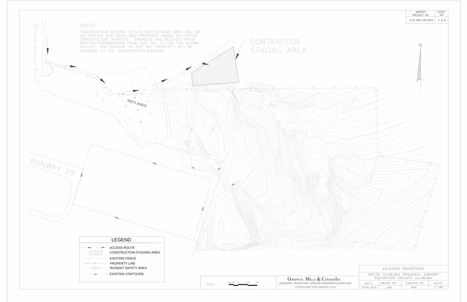
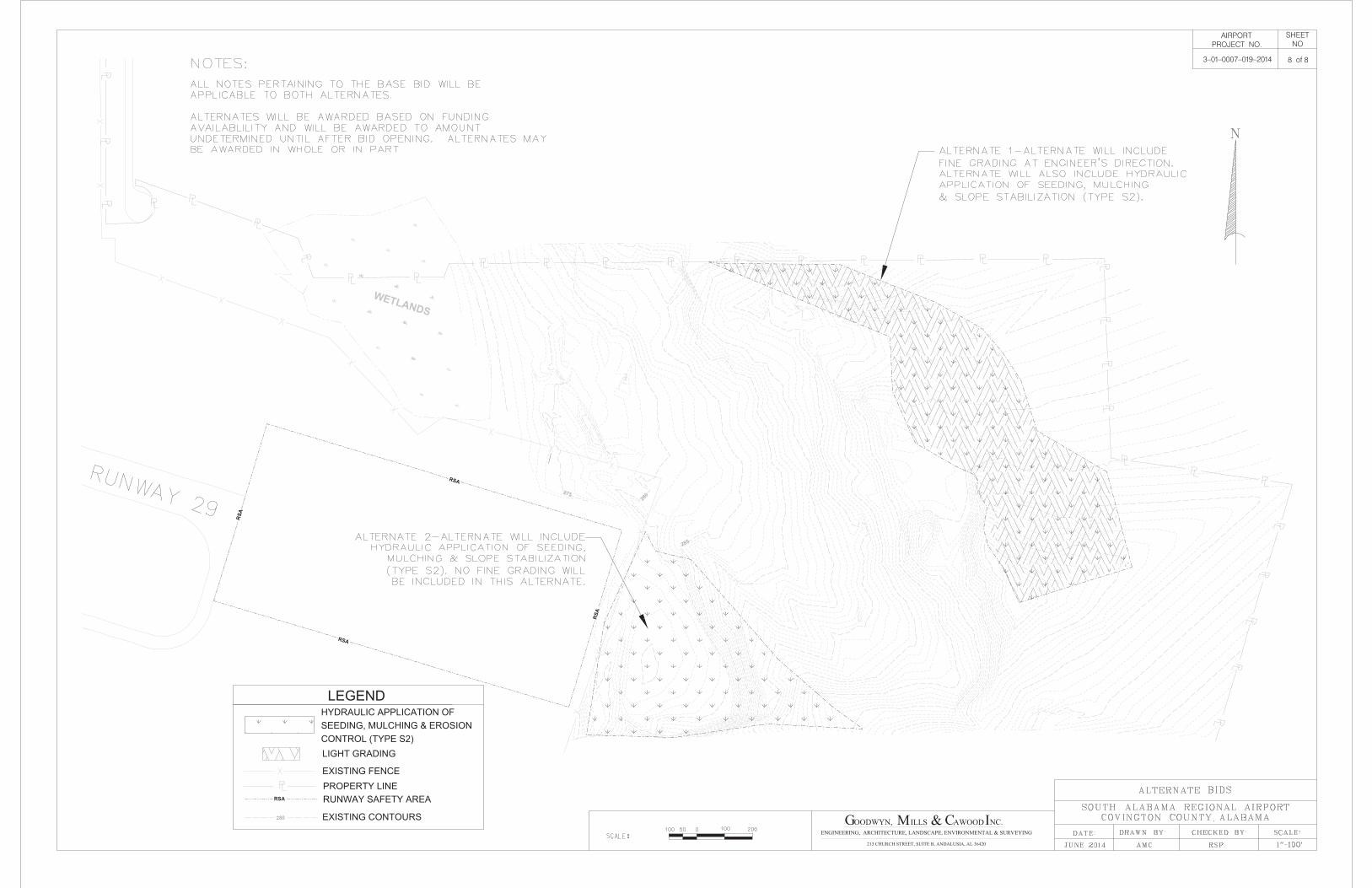
Appendix B Site Maps and BMP Details

1
C A W O O D
2660 EastChase Lane, Suite 200 | Montgomery, AL 36117
Tel 334.271.3200 | GMCNETWORK.COM
LEGEND
DISCHARGE POINT(S)
N
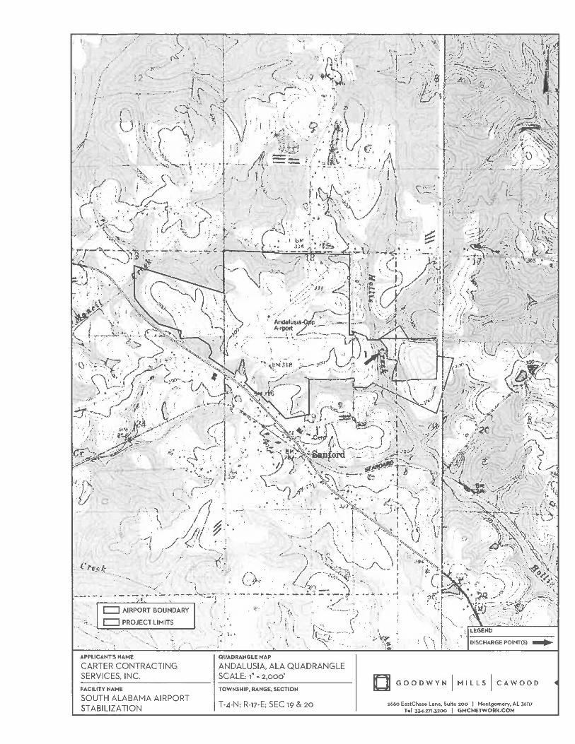
APPLICANT'S NAME QUADRANGLE MAP
FACILITY NAME TOWNSHIP, RANGE, SECTION
SCALE:
T-4-N; R-17-E; SEC 19 & 20
1" = 2,000'
ANDALUSIA, ALA QUADRANGLE
STABILIZATION
SOUTH ALABAMA AIRPORT
SERVICES, INC.
CARTER CONTRACTING
AIRPORT BOUNDARY
PROJECT LIMITS

0
NORTH Scale = 1" = 1,000'
2,000'1,000'500'
C A W O O D
2660 EastChase Lane, Suite 200 | Montgomery, AL 36117
Tel 334.271.3200 | GMCNETWORK.COM
GMC #
DATE:
DRAWN BY:
DESCRIPTION:
REF. SHEET:
ANDALUSIA, COVINGTON COUNTY, AL
STABILIZATION
SOUTH ALABAMA AIRPORT
CONSTRUCTION BEST MANAGEMENT PRACTICES PLAN
ESRI WORLD IMAGERY
NKC
06/09/2014
EAND144001
AERIAL PHOTO
APPX B
PROJECT LIMITS
0
NORTH Scale = 1" = 1,000'
2,000'1,000'500'
C A W O O D
2660 EastChase Lane, Suite 200 | Montgomery, AL 36117
Tel 334.271.3200 | GMCNETWORK.COM
GMC #
DATE:
DRAWN BY:
DESCRIPTION:
REF. SHEET:
ANDALUSIA, COVINGTON COUNTY, AL
STABILIZATION
SOUTH ALABAMA AIRPORT
CONSTRUCTION BEST MANAGEMENT PRACTICES PLAN
COVINGTON COUNTY SOILS SURVEY
NKC
06/09/2014
EAND144001
SOILS MAP
APPX B
PROJECT LIMITS


C A W O O D
2660 EastChase Lane, Suite 200 Montgomery, AL 36117

C A W O O D
2660 EastChase Lane, Suite 200 Montgomery, AL 36117

C A W O O D
2660 EastChase Lane, Suite 200 Montgomery, AL 36117

C A W O O D
2660 EastChase Lane, Suite 200 Montgomery, AL 36117

C A W O O D
2660 EastChase Lane, Suite 200 Montgomery, AL 36117

C A W O O D
2660 EastChase Lane, Suite 200 Montgomery, AL 36117
C A W O O D
2660 EastChase Lane, Suite 200 Montgomery, AL 36117

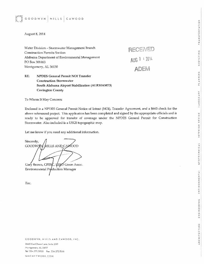
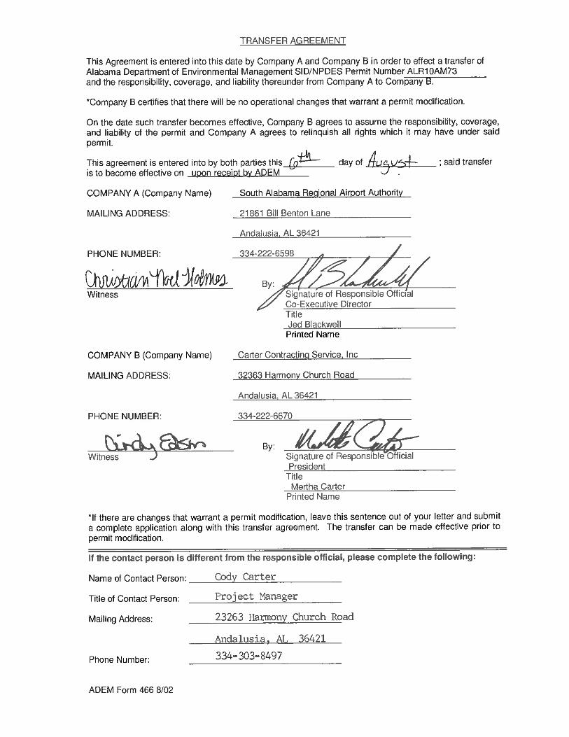
Appendix C NOI Application and Approval


Appendix D Inspection Reports

1 of 2ADEM Form 23 11-11
ADEM NPDES CONSTRUCTION STORMWATER INSPECTION REPORT AND BMP CERTIFICATION
RESPOND WITH “N/A” AS APPROPRIATE. FORMS WITH INCOMPLETE OR INCORRECT ANSWERS, OR MISSING SIGNATURES WILL BE RETURNED AND MAY RESULT IN APPROPRIATE COMPLIANCE ACTION BY THE DEPARTMENT. IF SPACE IS INSUFFICIENT, CONTINUE ON AN ATTACHED SHEET(S) AS NECESSARY. PLEASE TYPE OR PRINT IN INK.
Item I.
Permittee Name: Facility/Site Name:
Permit Number: County:
Facility Entrance Latitude & Longitude: Phone Number:
Facility Street Address or Location Description:
Item II.
List name of current ultimate receiving water(s) (indicate if through MS4) and the number of disturbed acres which drains through each treatment system or BMP: Add additional sheet(s) if necessary.
Receiving Water Disturbed Acres Discharge Point # Representative Outfall
YES NO
YES NO
YES NO
YES NO
YES NO
Item III.
1. YES NO Did discharges of sediment or other pollutants occur from the site? If “Yes”, please list a description of the discharge(s) and their location(s):
2. YES NO Were BMPs properly implemented and maintained at the time of inspection? If “No”, please provide location(s) and descriptions of BMPs that need maintenance:
3. YES NO Are BMPs needed in addition to those already present onsite at the time of inspection? If “Yes” please provide a description and location of additional BMPs that are needed:
4. YES NO Have any BMPs failed to operate as designed? If “Yes”, please provide location(s) and description of BMP(s) that failed:
5. YES NO Were there BMPs required by the CBMPP that were not installed or installed in a manner not consistent with the CBMPP? If “Yes”, please provide a description and location where the BMPs were not installed or installed incorrectly:
Item IV.
The Permittee shall conduct turbidity monitoring in accordance with Part V of the permit:
1. YES NO Is this facility a Priority Construction Site?
2. YES NO Has the facility disturbed greater than 10 acres?
3. YES NO Was the site discharging at the time of inspection?
4. YES NO Samples collected, if “Yes”, sampling data must be attached.
Carter's Contracting Service, Inc. South Alabama Airport Stabilization
ALR10 Covington
N031° 18' 30.81" W086° 23' 02.29" 334-222-6670
21861 Bill Benton Lane
UT to Hollis Creek 46.62 1 ✔
2 of 2ADEM Form 23 11-11
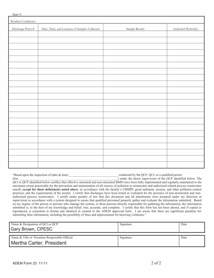
Item V.
Weather Conditions:
Discharge Point #
Date, Time, and Location of Samples Collected
Sample Results
Analytical Method(s)
“Based upon the inspection of (date & time)
(list:
conducted by the QCP, QCI, or a qualified person
) under the direct supervision of the QCP identified below. The
QCI or QCP identified below certifies that effective structural and non-structural BMPs have been fully implemented and regularly maintained to themaximum extent practicable for the prevention and minimization of all sources of pollution in stormwater and authorized related process wastewater
runoff, except for those deficiencies noted above, in accordance with the facility’s CBMPP, good sediment, erosion, and other pollution control practices, and the requirements of the permit. I certify that discharges have been tested or evaluated for the presence of non-stormwater and non-
authorized process wastewaters. I certify under penalty of law that this document and all attachments were prepared under my direction orsupervision in accordance with a system designed to assure that qualified personnel properly gather and evaluate the information submitted. Based
on my inquiry of the person or persons who manage the system, or those persons directly responsible for gathering the information, the informationsubmitted is, to the best of my knowledge and belief, true, accurate, and complete. I certify that this form has not been altered, and if copied or
reproduced, is consistent in format and identical in content to the ADEM approved form. I am aware that there are significant penalties for submitting false information, including the possibility of fines and imprisonment for knowing violations.”
Name & Designation of QCI or QCP Signature Date
Name & Title of Permittee Responsible Official Signature Date
Gary Brown, CPESC
Mertha Carter, President

Appendix E Corrective Action Log
CB
MPP
Con
tact
: Gar
y B
row
n, C
PESC
Insp
ectio
n D
ate
Insp
ecto
r Nam
eD
escr
iptio
n of
BM
P D
efic
ienc
yC
orre
ctiv
e Ac
tion
Nee
ded
(incl
udin
g pl
anne
d da
te/re
spon
sibl
e pe
rson
)
Proj
ect N
ame:
Sou
th A
laba
ma
Airp
ort S
tabi
lizat
ion
Dat
e Ac
tion
Take
n/R
espo
nsib
le
Pers
on In
itial
s
Cor
rect
ive
Actio
n Lo
g
Appendix F CBMPP
Amendment Log

CB
MPP
Am
endm
ent L
og
CB
MPP
Con
tact
: Gar
y B
row
n, C
PESC
Amen
dmen
t No.
Amen
dmen
t Pre
pare
d by
:
N
ame
and
Title
Dat
e of
Am
endm
ent
Des
crip
tion
of th
e Am
endm
ent
Proj
ect N
ame:
Sou
th A
laba
ma
Airp
ort S
tabi
lizat
ion

Appendix G Grading and
Stabilization Log
Gra
ding
and
Sta
biliz
atio
n A
ctiv
ities
Log
CB
MPP
Con
tact
: Gar
y B
row
n, C
PESC
Dat
e G
radi
ng
Activ
ity In
itiat
edD
escr
iptio
n of
Gra
ding
Act
ivity
Dat
e G
radi
ng
Activ
ity C
ease
d (In
dica
te T
empo
rary
or
Per
man
ent)
Dat
e W
hen
Stab
iliza
tion
Mea
sure
s ar
e In
itiat
ed
Des
crip
tion
of S
tabi
lizat
ion
Mea
sure
and
Loc
atio
n
Proj
ect N
ame:
Sou
th A
laba
ma
Airp
ort S
tabi
lizat
ion

Appendix H Training Log
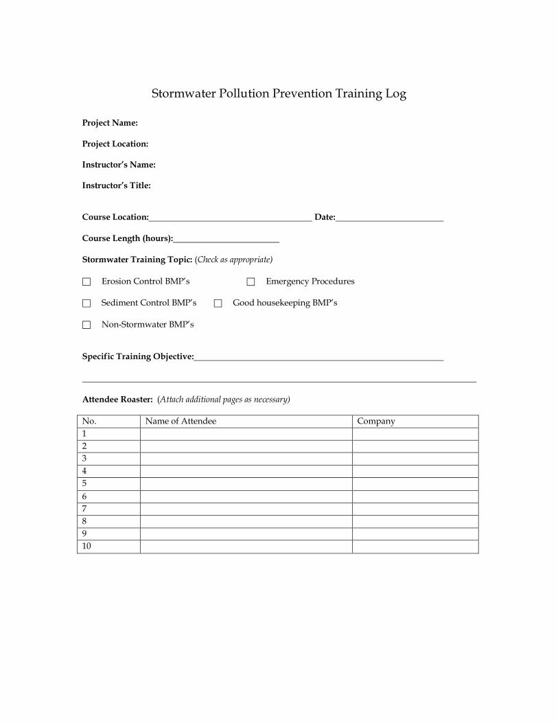
Stormwater Pollution Prevention Training Log
Project Name: Project Location: Instructor’s Name: Instructor’s Title: Course Location: Date: Course Length (hours): Stormwater Training Topic: (Check as appropriate) � Erosion Control BMP’s � Emergency Procedures � Sediment Control BMP’s � Good housekeeping BMP’s � Non-Stormwater BMP’s Specific Training Objective: Attendee Roaster: (Attach additional pages as necessary)
No. Name of Attendee Company
1
2
3
4
5
6
7
8
9
10

Appendix I Additional Information