COMPREHENSIVE SURVEY OF THE RIO DE LA PLATA AREA
12
COMPREHENSIVE SURVEY OF THE RIO DE LA PLATA AREA by Captain Luis R. A. C apurro Hydrographer, Argentine Navy I. — IMPORTANCE AND BACKGROUND OF THE PROBLEM 1. The Hydrographic System of the Rio de la Plata The hydrographic system of the Rio de la Plata (figures 1 and 2) is the second in importance in South America as regards physical values —- length and area of its basin, and volume of water it carries to the sea — but there is no doubt that it is the foremost as to economic significance, in which it excels the Amazon. This is only natural inasmuch as the Rio de la Plata is the main maritime gateway of Argentina and Uruguay, whose respective capitals: Buenos Aires (the largest city in South America) and Montevideo are situated on opposite banks of the river. The Plata basin is also the only gateway to the sea for Paraguay as well as Bolivia. Rio de la Plata, which is the result of the junction of the rivers Paranâ and Uruguay, is 280 km in length, and 220 km wide at its mouth — the imaginary line that runs from Cabo San Antonio (Argentina) to Punta del Este (Uruguay). Its area amounts to 35 000 km2. It is interesting to note that the mean flow of the Rio de la Plata basin is estimated at 34 000 cubic metres, a figure which this comprehensive survey of the area will confirm or rectify in due time. Physiographically speaking, the Plata basin is considered as the result of a geologic fault which has been filled by transported materials — clays, sands and detritus matter of organic origin — from the rivers Paranà and Uruguay and their tributaries, deposited to a depth of nearly one hundred metres. On account of its effluence into the Atlantic Ocean, and more especially because of the great width of its outflow, or mouth, the Rio de la Plata is exposed to the action of oceanic tides, and also to an active mixing of fresh and salt waters. This active mixing of waters gives the river estuarine features over a large area, and makes it necessary to study the hydraulic behavior of the river not on the basis of the conventional techniques employed in hydaulics, but on methods required by the most complicated estuarine conditions.
Transcript of COMPREHENSIVE SURVEY OF THE RIO DE LA PLATA AREA

COMPREHENSIVE SURVEY OF THE RIO DE LA PLATA AREA
by Captain Luis R. A. C a p u r r o
Hydrographer, Argentine Navy
I. — IMPORTANCE AND BACKGROUND OF THE PROBLEM
1. The H ydrographic System o f the Rio de la Plata
The hydrographic system of the Rio de la Plata (figures 1 and 2) is the second in importance in South America as regards physical values —- length and area of its basin, and volume of water it carries to the sea — but there is no doubt that it is the foremost as to economic significance, in which it excels the Amazon. This is only natural inasmuch as the Rio de la Plata is the main maritime gateway o f Argentina and Uruguay, whose respective capitals: Buenos Aires (the largest city in South America) and Montevideo are situated on opposite banks of the river. The Plata basin is also the only gateway to the sea for Paraguay as well as Bolivia.
Rio de la Plata, which is the result o f the junction o f the rivers Paranâ and Uruguay, is 280 km in length, and 220 km wide at its mouth — the imaginary line that runs from Cabo San Antonio (Argentina) to Punta del Este (Uruguay). Its area amounts to 35 000 km2. It is interesting to note that the mean flow of the Rio de la Plata basin is estimated at 34 000 cubic metres, a figure which this comprehensive survey of the area will confirm or rectify in due time.
Physiographically speaking, the Plata basin is considered as the result of a geologic fault which has been filled by transported materials — clays, sands and detritus matter of organic origin — from the rivers Paranà and Uruguay and their tributaries, deposited to a depth of nearly one hundred metres.
On account of its effluence into the Atlantic Ocean, and more especially because o f the great width o f its outflow, or mouth, the Rio de la Plata is exposed to the action of oceanic tides, and also to an active mixing of fresh and salt waters. This active mixing o f waters gives the river estuarine features over a large area, and makes it necessary to study the hydraulic behavior of the river not on the basis of the conventional techniques employed in hydaulics, but on methods required by the most complicated estuarine conditions.
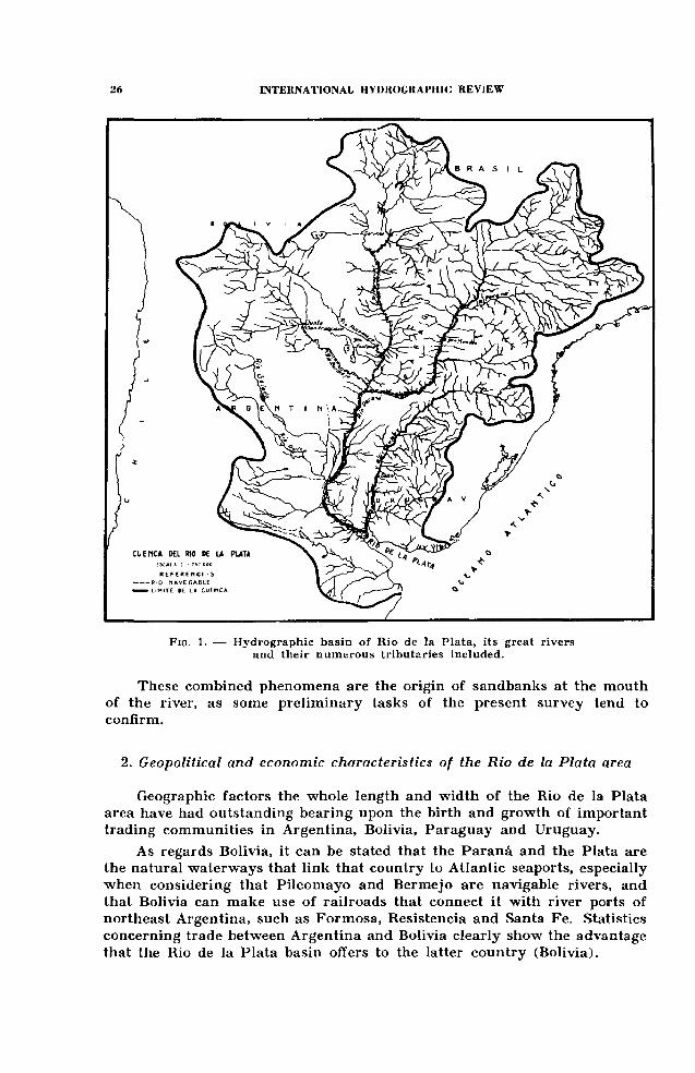
F ig . 1. — Hydrographic basin of Rio de la Plata, its great rivers and their numerous tributaries included.
These combined phenomena are the origin of sandbanks at the mouth o f the river, as some preliminary tasks of the present survey tend to confirm.
2. Geopolitical and economic characteristics of the Rio de la Plata area
Geographic factors the whole length and width o f the Rio de la Plata area have had outstanding bearing upon the birth and growth of important trading communities in Argentina, Bolivia, Paraguay and Uruguay.
As regards Bolivia, it can be stated that the Paranâ and the Plata are the natural waterways that link that country to Atlantic seaports, especially when considering that Pilcomayo and Bermejo are navigable rivers, and that Bolivia can make use of railroads that connect it with river ports of northeast Argentina, such as Formosa, Resistencia and Santa Fe. Statistics concerning trade between Argentina and Bolivia clearly show the advantage that the Rio de la Plata basin offers to the latter country (Bolivia).
As to Paraguay, its geographic situation between the rivers Paraguay and Parana causes the main share of its production to be channeled logically to foreign markets through the Rio de la Plata. Paraguay’s economy tends to develop mainly along the banks o f its namesake river, which is navigable almost all its length, from Bahia Negra down to its junction with the Paranâ — a total o f 1 174 km.
In spite of the fact that the distance along the rivers Paraguay and Paranâ is about 1 500 km, the advantage in river transportation is substantially greater than transportation by other means. This is a very positive encouragement to economic undertakings in Paraguay, inasmuch as lesser transportation costs represent, naturally, cheaper freight rates, as well as a saving of time in merchandise reaching its destination.
As regards Uruguay, the Rio de la Plata area, together with the area adjacent to the Uruguay river up to Salto (370 km upstream from its outlet into the Plata) has played, and continues to play, a vital influence in its politico-economic development.
Actually, the most densely populated and prosperous Uruguayan communities are located to the south of Rio Negro. About 70 per cent of the total population of the country lives along the lower reaches of the Uruguay and Plata rivers. Furthermore, there is a substantial river traffic between Uruguayan and Argentine ports in the area.
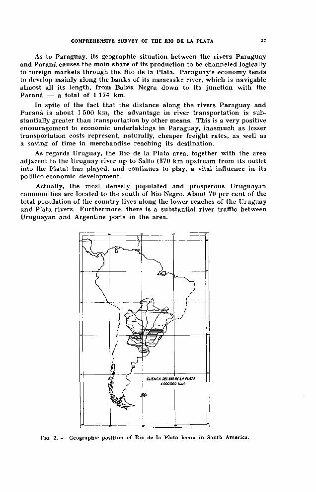
F ig . 2. — Geographic position of Rio de la Plata basin in South America.

Finally, as regards the Argentine Republic, it bears pointing out that the hydrographic system of the Rio de la Plata is intimately linked to its geographic and political unity, the Rio de la Plata area having been an outstanding and determinative factor in bringing about the birth o f Argentina as an independent nation, and its subsequent growth.
The huge network of the Rio de la Plata hydrographic system, which encompasses an area o f 4-1/2 million square kilometres, accounts for the force of attraction that in Argentina has its center in the most significant section of that network, which is specifically the section of the Rio de la Plata proper, but which extends its powerful influence to outlying territories beyond the reach of its many tributaries. The Rio de la Plata hydrographic system has grown in importance together with the country and has long since become Argentina’s foremost center for both foreign and domestic trade.
It is interesting to note in this respect that 92 per cent of Argentina’s importations, and 75 per cent of its exportation trade, enter and leave, respectively, through the port of Buenos Aires. This two-way traffic passes exclusively through channels which it is imperative to improve.
II. NEED OF A NEW SURVEY — MAIN TASKS PLANNED
The main interest in the Rio de la Plata lies, obviously, in its being a means of communication for maritime traffic, both foreign and domestic. But this interest is not the only one, because the exceptional growth of the city Buenos Aires has given rise to urban requirements that actually depend on its river for their solution. This explains why, besides navigable channels, a series of very important tasks have been undertaken which call for accurate information as to the hydraulic behavior of the river and its estuary.
The overall survey project includes the following specific tasks :a) planning of new navigable channels; b) surveying work for an international bridge across the Rio de la Plata, which is to become the first link of this nature between the sister republics of Argentina and Uruguay; c) preliminary work connected with the building of an artificial island just off the riverside area of Buenos Aires to be used as a domestic airport in place of the present one; d) new water intake installations for the city o f Buenos Aires and for greater Buenos Aires; also a study o f adequate discharge areas for the sewage and drainage systems of both the metropolitan and the suburban areas; e) contribution to the study of the enlargement and modernization of the port of La Plata; and /) improvement of existing facilities for nautical and riverside sports: sailing, rowing, game fishing, swimming, etc.
The comprehensive survey of the Rio de la Plata area will also mean a substantial contribution to other projects, the most important of which will be the future enlargement and improvement of the port of Buenos Aires. A system for the preservation o f the Paranâ delta is also being contemplated This system would include the construction of properly oriented levees.

The mere listing of the different ways in which it is contemplated to take full advantage of, and put to use, the Rio de la Plata area clearly shows the need of obtaining a thorough and comprehensive knowledge of the behavior of the river and its environmental conditions. This need goes beyond the construction of one or more nautical charts showing sounding depths, and all navigation aids in the river. It pressingly calls for the knowledge of other aspects, such as the kind of materials of the river bed, the depth at which the rock basement lies, the sedimentation processes, the hydraulic behavior of the river, a thorough study of geophysic conditions in the area, physical and chemical features of the waters, and their potential biological resources.
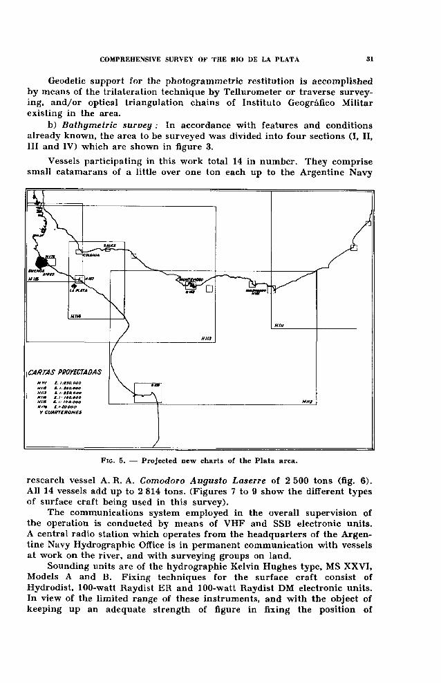
These diverse requirements led to the decision of carrying out a comprehensive survey of the Plata area. This multi-purpose survey fully justifies the title o f comprehensive that has been ascribed to it. On the other hand, the diversity of interests which are associated with the hydrographic system of Rio de la Plata made it necessary to include a larger area in the survey program. The whole area, which for practical reasons has been defined as the Plata area, is shown in figure 3.
F i g . 3 . — Sections into which the comprehensive survey of Rio de la Plata has been divided (Sections I, II, III and IV), and their respective areas in square kilometres.
This graph also shows the site of tide gauge and current measurement stations.

III. OPERATIONS CONNECTED WITH THE COMPREHENSIVE SURVEY OF RIO DE LA PLATA
1. Hydrographic survey
The objective sought by this survey is to produce 13 nautical charts (an oceanic chart, five coastal charts and seven plans). Furthermore, pilots will be brought up to date, and aids to navigation will be improved in accordance with findings arising from the survey. (Figures 4 and 5 show
charts currently available and charts to be constructed as a result o f the survey, respectively.) Apart from the 13 charts mentioned above, some special charts are also to be constructed, namely: geologic, magnetic, gravimetric, fishery, water temperature and salinity, military and small craft charts.
Tasks in the stage of execution corresponding to the hydrographic survey are being carried out in accordance with the program and techniques listed below:
a) Coastal survey : This survey is being accomplished by means of restitution techniques of aerial photogrammetric photos using 9" X 9" (23 X 23 cm) vertical photos taken at an altitude of 7 500 m (scale 1/50 000) ; coverage: lengthwise 60 %, sidewise 25 %, along the coastal margin to a width o f 15 km.
Geodetic support for the photogrammetric restitution is accomplished by means of the trilatération technique by Tellurometer or traverse surveying, and/or optical triangulation chains o f Instituto Geogrâfico Militar existing in the area.
b) Bathymetric survey : In accordance with features and conditions already known, the area to be surveyed was divided into four sections (I, II, III and IV) which are shown in figure 3.
Vessels participating in this work total 14 in number. They comprise small catamarans of a little over one ton each up to the Argentine Navy
research vessel A. R. A. Comodoro Augusto Laserre o f 2 500 tons (fig. 6). All 14 vessels add up to 2 814 tons. (Figures 7 to 9 show the different types o f surface craft being used in this survey).
The communications system employed in the overall supervision of the operation is conducted by means o f VHF and SSB electronic units. A central radio station which operates from the headquarters of the Argentine Navy Hydrographic Office is in permanent communication with vessels at work on the river, and with surveying groups on land.
Sounding units are of the hydrographic Kelvin Hughes type, MS XXVI, Models A and B. Fixing techniques for the surface craft consist of Hydrodist, 100-watt Raydist ER and 100-watt Raydist DM electronic units. In view of the limited range of these instruments, and with the object of keeping up an adequate strength of figure in fixing the position of

Fig. 6. — Research vessel A.R.A. Cnmodoro Augusto Laserre, o f 2 500 tons,w hich participates in the oceanic section o f the Plata survey (Section IV).This vessel is equipped with instrumentation and laboratories for all types
o f oceanographic tasks, also hydrographic ones.
vessels, it was decided to rig up in the river sixteen hydrographic towers, some o f w hich are already in operation. Besides serving as platform s for soundings, all o f these towers will be used to measure currents and tides. (Figure 10 shows one o f these towers in its site in m idstream ).
T he tandem technique is used for carrying out soundings with several vessels at a time. The master vessel keeps the geographic control o f the operation by permanent position fixes, and vessels operating on both sides fix their own position by reference to the master vessel. The normal w orking procedure is that o f one vessel at each side of the master one, the distance between them being 1 cm at the scale o f the “boat sheets” used for plotting data.
The tide gauging support for the sounding operations is carried out by means o f 26 tide gauges situated along the Argentine and Uruguayan riverside.
As regards the measurement o f currents, this is carried out by different techniques. The most usual one is that o f the coverage o f the area with m echanical, continuous recording current meters (Idrac, Neyrpic and Paddle W heel). As the survey progresses, up to eight current measurement stations will be occupied simultaneously. (Figure 3 shows the sites o f these current measurement stations, as well as those o f the tide gauges mentioned in the previous paragraph).
Plans are also being considered to measure direction o f currents by aerial photogram m etric techniques.
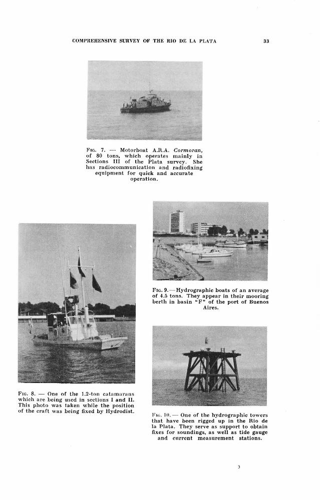
F ig . 7. — M otorboat A.R.A. Cormoran, o f 80 tons, which operates m ainly in Sections III o f the Plata survey. She has radiocom m unication and radiofixing
equipment for quick and accurate operation.
F ig . 8. — One o f the 1.2-ton catamarans which are being used in sections 1 and II.This photo was taken while the position o f the craft was being fixed by Hydrodist.
I'k.. 10.— One o f the hydrographic towers that have been rigged up in the Rio de la Plata. They serve as support to obtain fixes for soundings, as well as tide gauge
and current measurement stations.
F ig . 9. — Hydrographic boats o f an average o f 4.5 tons. They appear in their mooring berth in basin “ F ” o f the port o f Buenos
Aires.
2. Geological survey
This survey aims at describing the kind o f top sediments, the concentration and type of sediments in suspension, and the transport of sediments along the bottom. Geological bores, which will be carried out down to a depth o f 150 m, will supplement the information obtained by seismic survey of stratified layers in the river bed.
3. Geophysical survey
Geophysical elements to be surveyed are: the total earth magnetic field, and the gravity field. The description o f the fields of these geophysical elements answers scientific objectives rather than aspects of practical application. Nevertheless, this geophysical survey will furnish additional information for the general survey work which the Navy Hydrographic Office will carry out in collaboration with Lamont Geological Observatory of Columbia University.
The magnetic survey will be carried out by means o f an airborne magnetometer, with simultaneous observations on land as support.
The gravimetric survey does not have the continuous character of the magnetic survey inasmuch as selected points will be surveyed by underwater gravimeter monitored from the vessel. About 180 stations will be covered in this manner.
Finally, the possibility is being studied of obtaining the topographic structure o f the rock basement along several profiles by the seismic reflection technique.
4. Oceanographic survey
This survey aims at attaining a knowledge o f the physical and chemical characteristics of the river and its estuary as well as their dynamics. The estuarine characteristics of a large section o f the Rio de la Plata area are such that the strategy followed must provide sampling o f a synoptic nature. In view of the large number o f vessels operating at present, it is possible to cover simultaneously various oceanographic stations along profiles already selected.
Analyses o f samples will be classical ones at each complete oceanographic station, that is: temperature, salinity, oxygen content, alkalinity, pH, phosphates, nitrates, nitrites, silicates and ammonia.
As regards the dynamics of the waters, two different investigations have been contemplated. The first one points to the description of the field of horizontal movement, and it will be carried out by the direct measurement o f currents in the manner previously explained.
The second investigation points to the knowledge o f that part of the wave spectrum which deals with long-period oscillations of the mean river level and their possible causes. In this connection, it is interesting to note that Argentina has records that cover sixty years of tide gauging data, and
similar records covering meteorological observations. Drs. Walter M u n k and Gordon G r o v e s from the Scripps Institution of Oceanography will carry out this study, for which purpose those long-term data have been transferred to punched cards.
5. Other investigations
W ithin the scope of this comprehensive survey of the Rio de la Plata area some aspects of marine biology and fishery research have been included. These investigations point to a thorough description o f the area, in function o f habitat of aquatic species, and to the determination of the potential biological resources existing at present.
Finally, geographic investigations covering the whole area of the survey have been contemplated. To this end, the collaboration of Sociedad Argentina de Estudios Geogràficos (GEA) was requested. These investigations include the following tasks.
a) Preparation of reference cards for all the information available about the Rio de la Plata, its banks, islands, delta and approaches, including similar information for the eastern bank o f the river— that o f the Republic of Uruguay.
b) Reports on geomorphology, hydrology, political geography, projects and navigation, as well as on biogeography, and legal aspects.
c ) Evaluation of the geographic interests in the whole area of the survey.
IV. — COOPERATION WITH OTHER ARGENTINE NATIONAL AGENCIES AND INSTITUTIONS, AND WITH URUGUAY
As previously stated, the Rio de la Plata survey has the characteristics o f a multi-purpose survey. For this reason quite a number o f national agencies and institutions (listed below) participate in different aspects of the project, namely:
Direcciôn de Geologia y Minas (Bureau o f Geology and Mines); Secre- taria de Obras Püblicas — Direcciôn de Vialidad (Department o f Public W orks — Bureau of Highways); Direcciôn de Geodesia de la Provincia de Buenos Aires (Bureau of Geodesy of the Province of Buenos Aires) ; Instituto Geogrâfico Militar (Geographic Institute o f the Army) ; Obras Sanitarias de la Naciôn (Bureau of Water Supply and Sewerage); Comisiôn Nacional Puente Internacional del Rio de la Plata (National Committee for the International Bridge Across Rio de la Plata) ; Plan Regulador de la Ciudad de Buenos Aires (Master Plan for the City o f Buenos Aires); Agua y Energia Eléctrica (Bureau o f W ater Resources and Electric Power) ; Ministerio de Educaciôn y Justicia — Museo de Ciencias Naturales “ Bernardino Rivadavia” (Ministry o f Education and Justice — Museum of Natural Sciences “Bernardino Rivadavia” ) ; Universidad de Buenos Aires (University o f Buenos Aires); Universidad de La Plata (University of La Plata); INTI — Instituto Nacional de Technologia Industrial (National In«ti-

tude o f Industrial Technology) ; LEMIT — Laboratorio de Ensayo de Mate- riales e Investigaciones Tecnologicas (Laboratory for Materials Testing and Technological Research) ; Yacimientos Petrolîferos Fiscales (Government Oilfields Agency); Consejo Nacional de Investigaciones Cientificas y Técnicas (National Advisory Board on Scientific and Technological Research) ; Secre- taria de Agricultura y Ganaderia de la Naciôn — Direcciôn de Pesca (National Department of Agriculture and Livestock — Bureau of Fisheries).
The foregoing agencies and institutions take care of the study of problems o f their respective spheres of action, and participate in a specially created commission which is known by its initials C.L.I.A.P. (Comisiôn Levantamiento Integral del Area del Plata — Commission for the Comprehensive Survey of the Plata Area). This commission handles the strategic planning o f the survey, and the Hydrographic Office of the Argentine Navy takes care of the technical execution of the different tasks.
For its part, Uruguay has appointed a technical committee to cooperate in the survey, especially as regards problems of the eastern bank of the river.
V. — DURATION AND COST OF THE SURVEY
Tasks which this comprehensive survey encompasses were commenced in August 1963, and it is estimated that they will be finished by the middle of 1966. This means that the survey will require approximately three years to be completed.
As regards the cost o f the whole project, it is estimated that it will amount to 370 million Argentine pesos (a little less than 3 million dollars at the current rate of exchange), 130 millions pesos of which will mean an increase in assets.
An example o f the many advantages that Argentina will derive from this survey — considering here only the economic aspect of the problem — lies in the fact that the cost of 370 million pesos mentioned in the foregoing paragraph represents approximately one half of the amount the country can save in lower freight rates by having the channels leading to the port o f Buenos Aires properly dredged.