Comprehensive Outdoor Recreation Plan Village of...
38
Comprehensive Outdoor Recreation Plan Village of Argyle April 01, 2015
Transcript of Comprehensive Outdoor Recreation Plan Village of...

Comprehensive Outdoor Recreation Plan
Village of Argyle April 01, 2015
STAFF Larry Ward
Executive Director
Troy Maggied Planning Program Manager
Ed White Economic Development
Program Manager
Katherine Burk Assistant Planner
Mary Penn Associate Planner
James Winters Associate Planner
COMMISSIONERS
Grant County Bob Keeny*
Eileen Nickels Jerry Wehrle
Green County Arthur Carter* Nathan Klassy
Mike Doyle
Iowa County John Meyers* Todd Novak
Lafayette County Jack Sauer*
Timothy McGettigan Jeff Riechers
Richland County Jeanetta Kirkpatrick*
Robert Neal Smith Ray Schmitz
* denotes County Board Chair
P.O. Box 262 Platteville WI 53818
p: 608.342.1636 • f: 608.342.1220 e: [email protected] www.swwrpc.org
Table of Contents
Executive Summary ............................................................ 4
Introduction ....................................................................... 5
Goals and Objectives .......................................................... 6
Definitions and Classifications ........................................... 7
Plan Process ....................................................................... 9
Summary of Previous Outdoor Recreation Plans ............ 11
Description of the Planning Region ................................. 12
Outdoor Recreation Supply Inventory ............................. 20
Outdoor Recreation Needs Assessment .......................... 22
Statewide Comprehensive Outdoor Recreation Plan ...... 27
Recommendations for Outdoor Recreation .................... 28
Appendix A: Capital Improvement Schedule ................... 30
Appendix B: Maps ............................................................ 31

About SWWRPC Southwestern Wisconsin Regional Planning Commission (SWWPRC) is an extension of local government in
Southwestern Wisconsin. We provide low-cost expert planning and economic development services to the county,
city, village, and town governments of our five-county jurisdiction (Grant, Green, Iowa, Lafayette, and Richland
counties). We assist our local communities to save both time and money while planning for the future. SWWRPC
is one of nine Regional Planning Commissions in the State of Wisconsin and was created by an Executive Order in
1970.
Over 85% of our budget comes from funding outside the region, with the SWWRPC bringing in over $14 million of
economic development funding alone. We have leveraged these self-generated funds to help our counties and
their communities save costs and prevent redundancy while preparing for future challenges.
SWWRPC Vision We envision a southwestern Wisconsin that has met its full potential. A place that is recognized for its resilient
and diverse economy, high quality of life, and distinctive Driftless landscape. It will be a place where
interconnected bonds between individuals and organizations form strong communities of inclusion and
cooperation. Southwestern Wisconsin will be a place where the richness of the land contributes to the healthy
lives of its residents and visitors—and the stewardship of our natural resources is a shared and valued
responsibility. Our region will be a place that fosters innovation and creativity, inspiring and empowering thinkers
and doers. With deep respect for the traditions that built southwestern Wisconsin, we strive to create the best
possible region for tomorrow.
SWWRPC Mission The Southwestern Wisconsin Regional Planning Commission collaborates with communities and organizations to
build capacity within southwestern Wisconsin, serving as advocates for its residents. We create opportunities and
develop dynamic solutions to the challenges facing the region. We foster growth by supporting innovative
endeavors that provide tangible benefits to those we serve. We believe in the bold vision of southwestern
Wisconsin and work to build the region’s future.
About the Village of Argyle Nestled into the rolling hills of northeastern Lafayette County, the community of Argyle and the surrounding area are appealing both to residents and to visitors. Argyle was founded in 1844 by Allan Wright, a Scotsman who named it after the Duke of Argyll. Today, Argyle is home to over 800 residents. Its location on the Pecatonica River and its proximity to Yellowstone Lake make it an ideal location for outdoor recreation.
4 Comprehensive Outdoor Recreation Plan: Village of Argyle
Executive Summary Purpose This plan is an update of the Argyle Outdoor Recreation Plan prepared in 2006. Specifically, this plan will guide the
development and improvement of the village’s outdoor recreation facilities over the next five years in order to meet the
recreational needs and demands of local residents.
Policy decisions made by the Argyle Park Commission and the Argyle Village Board for park programs and improvements
shall be guided by the goals, objectives, findings, and recommendations of this adopted plan. Actual public policy
decisions are contingent on funding sources, new opportunities, changing growth patterns, budget priorities, and
changing community needs and desires. For this reason the plan should be reviewed annually and a detailed update
such as this should be completed every five years. Updating the plan every five years is also a requirement of the State
of Wisconsin Department of Natural Resources for a community such as Argyle to stay eligible for matching government
funds for parkland acquisition and facility improvements. But just as importantly, the Village of Argyle needs to set a
course of action for continued improvement of its parks and outdoor recreational system.
Goals The Village of Argyle obviously takes pride in this role by virtue of its excellent park system. The goals and objectives below
are vital to the efforts in providing this important service
Continue to provide excellent maintenance to Argyle’s parks and recreation facilities
o Continue to make Argyle more handicap accessible by incorporating updates into the formal
maintenance schedule
o Expand the parking lot at Legion Field to make the Erickson Wetland trail more handicap accessible
Develop new parks and recreational facilities that meet the need of Argyle residents and visitors
o Create a new park near the water tower
o Create a less-steep boat ramp on the southern branch of the Pecatonica River to provide easier access
to the shallow portion of the river
o Develop a Recreational Vehicle campsite on the river near the Old Dam Fishing Site and the Argyle Boat
Launch
o Upgrade and lengthen the Erickson Wetland trail near Legion Park
Continue to utilize existing funding streams and find new funding solutions for Argyle’s park system
o Explore new funding opportunities for updating and expanding existing park equipment
Recommendations Even though Argyle is a small community, it has a great need of additional park space. Under the current park and open
space classification system, Argyle has enough open space for its population of 857 people. However, accessibility to the
existing community parks is limited by the highways that dissect Argyle. Currently, only half of the village is able to safely
walk to a village park. This plan has features two sets of recommendations 1) to strengthen existing park assets though
ongoing maintenance improvements and by providing additional park amenities 2) to strategically acquire additional park
space to allow for the needs of existing Argyle residents while anticipating their needs for the future.

5 Comprehensive Outdoor Recreation Plan: Village of Argyle
Image 1: Erickson Wetlands
Introduction This comprehensive outdoor recreation plan for the Village of Argyle is an expression of the community’s goals for and
objectives for current and future needs for recreational facilities. The intent of this document is to plan for the
maintenance and improvement of Argyle’s recreational and open space resources by outlining a strategy to manage
existing resources and to develop new resources to meet future needs and demands.
Parks can serve a limited neighborhood area, a portion of the community, or the entire community or region and provide
area and families for outdoor recreation for residents and visitors. Open space can take the form of parks, greenbelts,
wetlands, and floodplains. Open space can also serve many functions for a community other than recreation, such as the
following:
Preservation of scenic and natural resources
Flood management
Protecting the area’s water resources
Preserving prim agricultural land
Limiting development that may occur
Buffering incompatible land uses
Structuring the community environment
A parks and facilities plan should incorporate private as well as public open space areas in the community. The
development and continual updating of the outdoor recreation plan becomes a valuable asset to a community and
contributes to its stability and attractiveness.
Plan Purpose This plan is an update of the Argyle Outdoor Recreation Plan prepared in 2006. The specific purpose of this plan is to guide
the development and improvement of the village’s outdoor recreation facilities over the next five years in order to meet
the recreational needs and demands of local residents.

6 Comprehensive Outdoor Recreation Plan: Village of Argyle
Policy decisions made by the Argyle Park Commission and the Argyle Village Board for park programs and improvements
shall be guided by the goals, objectives, findings, and recommendations of this adopted plan. Actual public policy decisions
are contingent on funding sources, new opportunities, changing growth patterns, budget priorities, and changing
community needs and desires. For this reason the plan should be reviewed annually and a detailed update such as this
should be completed every five years. Updating the plan every five years is also a requirement of the State of Wisconsin
Department of Natural Resources for a community such as Argyle to stay eligible for matching government funds for
parkland acquisition and facility improvements. But just as importantly, the Village of Argyle needs to set a course of action
for continued improvement of its parks and outdoor recreational system.
Image 2: American Legion Community Park Walkway
Goals and Objectives One of the most important roles of local government is its responsibility to provide open space, parks and recreation
facilities and programs for public use. The Village of Argyle obviously takes pride in this role by virtue of its excellent park
system. This portion of the Updated Comprehensive Outdoor Recreation Plan is to provide village officials with some
general policies to show in guiding the future growth and development of Argyle’s park system and outdoor recreation
facilities. The goals and objectives below are vital to the efforts in providing this important service. More information on
how these goals were formed can be found in the Outdoor Recreation Needs Assessment on page 22.
Continue to provide excellent maintenance to Argyle’s parks and recreation facilities
o Continue to make Argyle more handicap accessible by incorporating updates into the formal
maintenance schedule
o Expand the parking lot at Legion Field to make the wetland trail more handicap accessible
Develop new parks and recreational facilities that meet the need of Argyle residents and visitors
o Create a new park near the water tower
o Create a less-steep boat ramp on the southern branch of the Pecatonica River to provide easier access
to the shallow portion of the river
o Develop a Recreational Vehicle campsite on the river near the Old Dam Fishing Site and the Argyle Boat
Launch
o Upgrade and lengthen the wetland trail near Legion Park
Continue to utilize existing funding streams and find new funding solutions for Argyle’s park system
o Explore new funding opportunities for updating and expanding existing park equipment

7 Comprehensive Outdoor Recreation Plan: Village of Argyle
Definitions and Classifications Recreation Open Space Need Standards Standards can be a good starting point or reference when determining a community’s outdoor recreation land and facility
needs, however each community’s needs are different based on such factors as a community’s demographic profile and
what types of facilities and outdoor recreation priorities the citizenry deem important.
Resident input in the form of surveys and/or public hearings are also important when recreation and park planners look
at future development and/or preservation of public lands. Based on recommendations from the DNR and SWWRPC the
standard of 12 acres of developed park lands/open space per 1,000 population is used throughout this plan. This figure is
viewed as a target number when recreation and park planners analyze a community’s park, recreation land, and open
space composition. The National Recreation and Park Association (NRPA) endorsed a park and open space classification
system which will serve as a guide for the Village of Argyle.
NRPA’s standards have been modified to more accurately define park, recreation land, and open spaces within the Village
of Argyle. For example, NRPA recommends that a Neighborhood Park/Playground have a desirable size of 15+ acres. In
Argyle, most parks of this nature are in the 1 to 10 acre range. This has been noted in the definition section below. All
parks, recreation lands and open space under the jurisdiction of the Village of Argyle or the Argyle School district have
been assigned one primary classification or code using the following titles and abbreviations:
M-P: Mini Park (or Tot Lot)
o Desirable/Typical Size: 1 acre or less
o Service Area: 1/8 – 1/4 mile
o Acres/1,000 Population: 0.5 – 1.0 acre
o Use: Specialize facilities that serve a concentration of limited population or groups such as senior
citizens or young children
o Site Characteristics: Within neighborhoods and in close proximity to concentrations of family housing or
housing for the elderly
NP/P: Neighborhood Park/Playground
o Desirable/Typical Size: 1 to 10 acres
o Service Area: 1/4 – 1/2 mile radius
o Acres/1,000 Population: 2 – 3 acres
o Use: Area for intense recreational activities such as field games, court games, crafts, playground
apparatus area, ice skating, picnicking, volleyball, etc.
o Site Characteristics: Suited for intense development; easily accessible to neighborhood population;
geographically centered with safe walking and biking access. May be developed as a joint school/park
facility
C/CP: Community Park
o Desirable/Typical Size: 10 to 25 acres
o Service Area: 1 – 2 miles
o Acres/1,000 Population: 6 - 9 acres
o Use: Area of diverse environmental quality. May include areas suited for intense recreational facilities
such as athletic complexes or large swimming pools. May be an area of natural quality for outdoor
recreation such as walking, viewing sitting, and picnicking. May be any quality for outdoor recreation
such as walking, viewing, sitting and picnicking. May be any combination of the above depending on site
suitability and community need.

8 Comprehensive Outdoor Recreation Plan: Village of Argyle
o Site Characteristics: May include natural features such as water bodies and areas suited for intense
development. Easy access by all modes of transportation.
SU: Special Use Area
o Desirable/Typical Size: Variable depending on type of facility
o Service Area: Entire Community
o Acres/1,000 Population: Variable
o Use: Areas for specialized or single purpose recreational activities such as golf courses, nature centers,
marinas, zoos, conservancies, arboreta, display gardens, arenas, outdoor theaters, gun ranges, and
downhill ski areas. Also plazas or squares in or near commercial centers boulevards or parkways.
o Site Characteristics: Located within the community
LP: Linear Park
o Desirable/Typical Size: Sufficient width to protect resources and to provide maximum use
o Service Area: No applicable standard
o Acres/1,000 Population: Variable
o Use: Are developed for one or more varying modes of recreational travel or activity such as hiking,
biking, snowmobiling, horseback riding, fitness trails/cross-country skiing and canoeing. May include
active play areas.
o Site Characteristics: Built on natural corridors such as utility or railroad right-of-way, bluff lines,
vegetation patterns and roads that link other components of the recreation system or community
facilities such as school, libraries, commercial areas, and other park areas.
Recreational Facilities Development Need Standards Facility standards for the development of recreation facilities are similar to open space standards because they are
expressed in facility units per population ratio. The purpose of evaluating a recreation system from a facility viewpoint, in
addition to an open space viewpoint is to determine the amount of needed facility development in each recreation area.
Problems related to using facility development standards can be seen in the assumption of desired opportunities by the
resident population. For example, an examination of the facilities standards may show that a horseshoe area is needed
based on the municipality’s population. In reality, it is possible that very few people in the community enjoy playing
horseshoes, which may eliminate the need for this type of facility.
Age, income, and education all contribute to the people’s recreational preferences, yet facility standards sometimes
ignore these variables. Another problem with using standards is that they have developed primarily for urban communities
and have limited application to rural areas.
Despite these problems, facility development standards have a place in recreation planning. Community leaders can use
them to approximate the adequacy of their park systems. A listing of recreation facility development standards, prepared
by the American Planning Association and the United States Access Board can be found on their respective websites:
American Planning Association Outdoor Recreation Facility Standards:
https://www.planning.org/pas/at60/report194.htm
United States Access Board:
http://www.access-board.gov/guidelines-and-standards/recreation-facilities/outdoor-developed-areas

9 Comprehensive Outdoor Recreation Plan: Village of Argyle
Plan Process There are four essential baseline functions in developing a community’s outdoor recreation plan:
1. Understanding historical budget trends
2. Creating an inventory of existing community recreational assets and facilities
3. Development of relevant data and trends
4. Coordinating outreach to the population that uses Argyle’s outdoor recreation facilities
To develop Argyle’s Comprehensive Outdoor Recreation Plan, SWWRPC tackled these four baseline functions, while
receiving guidance from Wisconsin Department of Natural Resources. These four elements were used to develop priorities
with the Village of Argyle Parks Board. These priorities became the plan goals and objectives listed in this document.
Figure 1: Plan Process
Each baseline function provided the planning process with essential insight into the community’s assets, needs, and
priorities; and were essential for the development of the final plan. To understand Argyle’s budget, SWWRPC examined
Argyle’s parks budget from 2005 to 2012. This process was used to recognize patterns and the consistency between the
amount budgeted, the amount spent, and the difference between them. To create an inventory of existing community
recreational assets, SWWRPC used interns from the University of Wisconsin-Platteville to conduct an on-site inventory of
existing parks, facilities, and equipment. These interns used state-provided metrics for ranking recreation assets. The
results of the inventory were presented to the Argyle Park Board and used to develop priorities, plan goals, and objectives.
Data and mapping is an activity that was carried throughout the planning process. SWWRPC compiled data related to the
village’s age, demographics, and economic makeup and mapped it in relation to the existing parks. Finally, outreach is the
most important plan activity. SWWRPC developed a survey and distributed it widely within the community. Copies were
available in print and online. Over 177 responses were compiled by the end of the planning process. This information and
a summary from all plan activities were presented in a public forum to the Argyle Park Board on January 29, 2015 where
plan goals and objectives were developed for the final planning document. Park Board and community feedback from the
January 29th Public Forum were compiled and added to the plan, incorporating implementation strategies for formal
adoption and approval.
Budget
Inventory
Outreach
Plan Goals
and Objectives
State Guidance
Final Plan
Document
Data and Mapping

10 Comprehensive Outdoor Recreation Plan: Village of Argyle
Table 1: Plan Activities
Activity Date Conducted
Budget Analysis October 2014 – January 2015
Park Inventory August 2014 – September 2014
Data and Mapping June 2014 – January 2015
Outreach October 2014 – January 2015
Plan Development January 2015 – March 2015
Approval March 2015
Amending the Plan Plan amendments are common and should be considered part of the planning process. They frequently represent
good implementation or plan usage and should be acceptable for consideration by local decision makers.
Amendments must follow the same process as when the original plan was prepared. Amendments generally prolong
the effectiveness of the original plan.
The following steps will ensure the new amendment is approved with respect to state statues and to the citizens of
Argyle.
1. Initial meetings/framing the amendment: Depending on the size and scope of the amendment, the Park
Supervisor and the Park Board meet several times to discuss the proposed amendment.
2. Opportunity for Public Input: A public forum should be provided with ample time for the community to know
about the proposed changes to the plan. Then a public meeting should be held so the community can understand
the need for amendment and have an opportunity to provide direct feedback on the proposed changes.
3. Draft Amendment: The Park Supervisor and Park Board develop a draft amendment that still captures the need
for the amendment and feedback from the public.
4. Amendment Adoption: At an official public meeting, with 30 days of notice, the village council will vote to approve
the plan amendment with the recommendation of the Park Board.
5. DNR Approval: The council action on the plan amendment should be sent in writing to the Department of Natural
Resources for re-certification of the village’s Comprehensive Outdoor Recreation Plan with the new changes. The
plan amendment will not be effective until a letter is received from DNR indicating their approval.
Image 3: American Legion Community Park/Argyle School Basketball Courts
11 Comprehensive Outdoor Recreation Plan: Village of Argyle
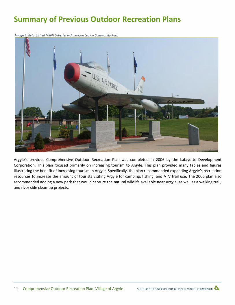
Summary of Previous Outdoor Recreation Plans
Argyle’s previous Comprehensive Outdoor Recreation Plan was completed in 2006 by the Lafayette Development
Corporation. This plan focused primarily on increasing tourism to Argyle. This plan provided many tables and figures
illustrating the benefit of increasing tourism in Argyle. Specifically, the plan recommended expanding Argyle’s recreation
resources to increase the amount of tourists visiting Argyle for camping, fishing, and ATV trail use. The 2006 plan also
recommended adding a new park that would capture the natural wildlife available near Argyle, as well as a walking trail,
and river side clean-up projects.
Image 4: Refurbished F-86H Saberjet in American Legion Community Park

12 Comprehensive Outdoor Recreation Plan: Village of Argyle
Description of the Planning Region
Social characteristics of Argyle According to the Census, the Village of Argyle is a small community in Lafayette County with 857 residents. Argyle’s ethnic
population is largely homogenous, 99.6% of the village’s populations being white. Argyle’s lack of ethnic diversity is
standard for the Southwestern Wisconsin Region, however it lags behind the state average, with 86% white and a 14%
split of other ethnicities, black being the highest at 6%.
While many communities in Southwestern Wisconsin are aging, the Village of Argyle maintains a median age of 36.4,
similar to the State of Wisconsin’s median age of 38.5. However, 55% of the community is between 20 and 64 years old.
Only a little over half of the community is of working age.
Table 2: Argyle Age Cohorts
Total
Population Total Male Total Female
Total Population 857 100.0% 444 51.8% 413 48.2%
Under 5 years 58 6.8% 28 3.3% 30 3.5% Total "youth"
population
232
27% of total
population
5 to 9 years 60 7.0% 37 4.3% 23 2.7%
10 to 14 years 62 7.2% 35 4.1% 27 3.2%
15 to 19 years 52 6.1% 30 3.5% 22 2.6%
20 to 24 years 57 6.7% 34 4% 23 2.7%
Total working-age population
477
55% of total
population
25 to 29 years 60 7.0% 28 3.3% 32 3.7%
30 to 34 years 45 5.3% 23 2.7% 22 2.6%
35 to 39 years 37 4.3% 21 2.5% 16 1.9%
40 to 44 years 60 7.0% 20 2.3% 40 4.7%
45 to 49 years 71 8.3% 41 4.8% 30 3.5%
50 to 54 years 70 8.2% 42 4.9% 28 3.3%
55 to 59 years 42 4.9% 22 2.6% 20 2.3%
60 to 64 years 35 4.1% 21 2.5% 14 1.6%
65 to 69 years 34 4.0% 12 1.4% 22 2.6% Total retired-
age population
148
17% of total
population
70 to 74 years 42 4.9% 18 2.1% 24 2.8%
75 to 79 years 27 3.2% 11 1.3% 16 1.9%
80 to 84 years 25 2.9% 14 1.6% 11 1.3%
85 years and over 20 2.3% 7 0.8% 13 1.5%
Source: DP Table-1, US Census 2010
Figure 2 is a population pyramid that shows a snapshot of Argyle’s population taken from the 2010 Census. The pyramid
has a narrow bottom and only widens slightly in the middle, and tapers off at the top. This has every indication without
in-migration to Argyle that Argyle’s population will likely decline in the future.

13 Comprehensive Outdoor Recreation Plan: Village of Argyle
Figure 2: Argyle Population Pyramid
However, population projections from the Wisconsin Department of Administration (DOA) indicate that Argyle’s
population will increase. According to the DOA, Argyle’s population will increase consistently from 2015 to 2040. Because,
Argyle lacks a strong youth population, this increase in population is likely due to in-migration.
Figure 3: Argyle Population Projection
50 40 30 20 10 0 10 20 30 40 50
Under 5 years
5 to 9 years
10 to 14 years
15 to 19 years
20 to 24 years
25 to 29 years
30 to 34 years
35 to 39 years
40 to 44 years
45 to 49 years
50 to 54 years
55 to 59 years
60 to 64 years
65 to 69 years
70 to 74 years
75 to 79 years
80 to 84 years
85 to 89 years
90 years and over
Village of Argyle
Females
Males
830
840
850
860
870
880
890
900
910
2010 Census 1/1/2013Estimate
2015 2020 2025 2030 2035 2040
Argyle Population Projection
Source: DP Table-1, US Census 2010
Source: Wisconsin Department of Administration

14 Comprehensive Outdoor Recreation Plan: Village of Argyle
Economy While Argyle is too small of a community to have a designated “Metropolitan Statistical Area,” it is the only municipality within the 53504 zip code. So while, the 53504 zip code is larger than Argyle’s municipal boundary, some data can be used to gain an understanding of the local economy, even if it is not 100% defined by Argyle’s village limits. Within the 53504 zip code, the local economy is driven by businesses within the “Animal Production,” and “All Other Miscellaneous Fabricated Metal Product Manufacturing.” Within the same zip code, containing Village of Argyle and some additional territory, is an estimated 6.3% unemployment rate and approximately 53 people at or below poverty level. The average annual earnings for people living in this area is $32,600.
Physical Characteristics of the Region
Location The Village of Argyle is approximately .62 square miles of territory that sits near the eastern border of Lafayette County.
Its location in Southwestern Wisconsin. Immediately to the northwest of Argyle are well-preserved natural wetlands,
maintained by the Wisconsin Department of Natural Resources. The natural resource of Erickson Wetlands has the
potential to be a valuable local and regional recreation asset.
Figure 4 is a map depicting Argyle’s distance to other recreation areas. Argyle is well-positioned to provide residents with
nearby recreation activities. Within 25 miles residents can utilize Yellowstone Lake State Park, Yellowstone Golf Course,
Blackhawk Memorial Park, and others. Within 50 miles residents can utilize Governor Dodge State Park, Blackhawk Lake
Recreational Area, Badfish Creek State Wildlife Area, and more.
Figure 5 is a map that illustrates the local recreational assets within the Village of Argyle. Even though Argyle is a relatively
small community, residents can enjoy recreation at several local parks, or enjoy the immediate natural recreation areas
such as Erickson Wetlands.

15 Comprehensive Outdoor Recreation Plan: Village of Argyle
Figure 4: Argyle’s Distance to other Recreation Areas
Figure 5: Argyle Parks and Features

16 Comprehensive Outdoor Recreation Plan: Village of Argyle
Walkability In terms of walkability, approximately 50% of the village is within walking distance of a park. There are very few
recreational assets on the east side of the village, and access to recreational assets is prohibited by Highway 81. A
potential site to remedy this issue would be where the water tower is located, in the northeast corner of the village.
Figure 6 is a map that illustrates the existing park walkability within the Village of Argyle. The yellow buffers around a
park indicate the space that is considered “walkable.” These spaces are within a quarter-mile of a park, however these
buffers can be cut short by roads or natural features that are difficult for a pedestrian to cross.
Figure 6: Park Walkability
17 Comprehensive Outdoor Recreation Plan: Village of Argyle
Topography Argyle is located in a geographic area known as the “Driftless Region.” The Driftless Region is classified as an area that
avoided “glaciation,” when prehistoric glaciers melted, carving the landscape and creating lakes through the Midwest.
Because Argyle is in the Driftless Region it does not have many natural lakes, instead its landscape is defined by rivers,
streams, and hills. Argyle, and the region surrounding it, is defined by its steep hills and deep valleys. The Pecatonica River
is a prominent geographical feature of the area. The river cuts into Argyle from the west and bends suddenly, traveling
south.
Argyle is located at the intersection of Wisconsin State Highway 78 and 81. While Argyle is nestled in a rural setting, the
existing infrastructure allows for easy access to regional economic hubs like Monroe and Darlington. However its isolation
makes it difficult to travel to larger cities such as Madison and Dubuque.
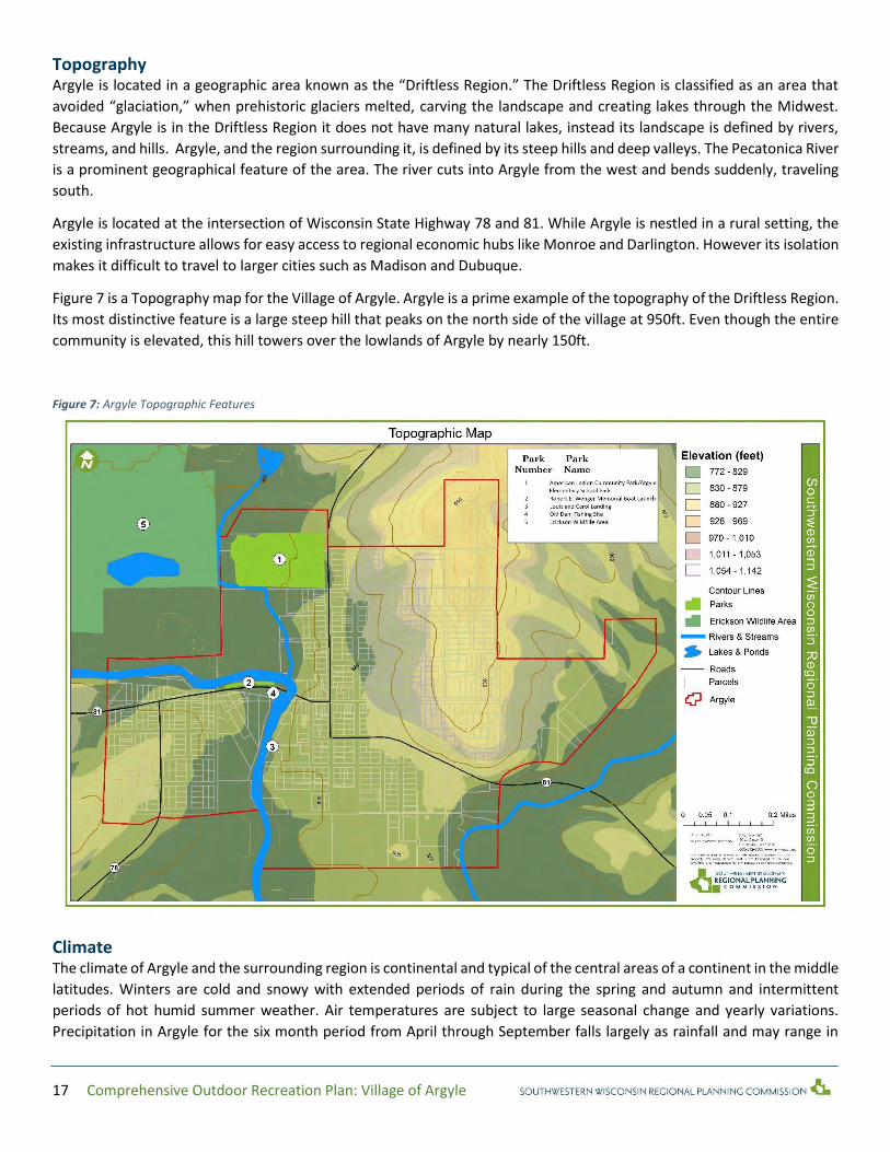
Figure 7 is a Topography map for the Village of Argyle. Argyle is a prime example of the topography of the Driftless Region.
Its most distinctive feature is a large steep hill that peaks on the north side of the village at 950ft. Even though the entire
community is elevated, this hill towers over the lowlands of Argyle by nearly 150ft.
Figure 7: Argyle Topographic Features
Climate The climate of Argyle and the surrounding region is continental and typical of the central areas of a continent in the middle
latitudes. Winters are cold and snowy with extended periods of rain during the spring and autumn and intermittent
periods of hot humid summer weather. Air temperatures are subject to large seasonal change and yearly variations.
Precipitation in Argyle for the six month period from April through September falls largely as rainfall and may range in

18 Comprehensive Outdoor Recreation Plan: Village of Argyle
intensity and duration from showers to destructive thunderstorms. The snowfall average for Lafayette County is about 40
inches annually. Prevailing winds are westerly in winter and southerly in summer.
Soils Throughout the Driftless Region the work of weathering as continued since long before glacial period and produced a
mantel of residual soil. This forms a notable contrast with the remainder of the state, where the continental glacier scraped
away nearly all the residual soil and left a sheet of transported soil. Generally the soils of the region have been classified
as the Grayish-Brown Unglaciated Silt Loam, hilly or steep. There soils were formed from parent materials reflecting native
vegetation such as prairie, oak-hickory, forestry and oak savannas. Their basic materials include clay residue from
weathered limestone, weathered sandstone and loess stream-laid sand and gravel. The latter occurs in valleys of large
streams, while the first three are wide spread. The entire southwest Wisconsin region is covered with a thick blanket of
loess (windblown silt and sand). Over most of the region the loess is largely silt and is two to three feet thick. In addition
some sandy areas along the Wisconsin River have active dunes.
Figure 8 shows the distribution of soil resources within the Village of Argyle. The majority of the village sits on top of the
Dubuque soil group. Dubuque soils are defined as “silty and well drained.” These soils have a low natural fertility,
however within the right conditions they can hold a lot of moisture. The second largest soil group is from the Hixton
series. Unlike the Dubuque soils, Hixton soils are less fertile and shed water at a rapid rate.
Figure 8: Argyle Soil Resources
Flora and Fauna
According to the Wisconsin Department of Natural Resources, Wisconsin supports over 650 different types of mammals,
birds, reptiles, amphibians, fish, and countless millions of invertebrates. In Southwestern Wisconsin white-tailed deer,
foxes, cottontail rabbits, skunks, woodchucks, squirrels, chipmunks, bats, and gophers are common.
19 Comprehensive Outdoor Recreation Plan: Village of Argyle
However, all Wisconsin wildlife is native. A number of invasive species have been introduced to Wisconsin. Some species
can be useful, but other are very destructive to the natural habitat. Some invasives include the ring-necked pheasant,
Hungarian partridge, rainbow trout and brown, carp, zebra mussel, ruffe, mute swan, starling, house sparrow, pigeon,
Norway rat and house mouse, emerald ash boar.
While the immediate area around Argyle includes mostly developed farmland, Erickson Wetlands are nearby. Common
plants in the wetlands include many varieties cattails bulrushes, pickerelweed, lake sedges, tag alder, bog birch, willow,
dogwood, tamarack, white cedar, black spruce, elm, green ash, and silver maple.
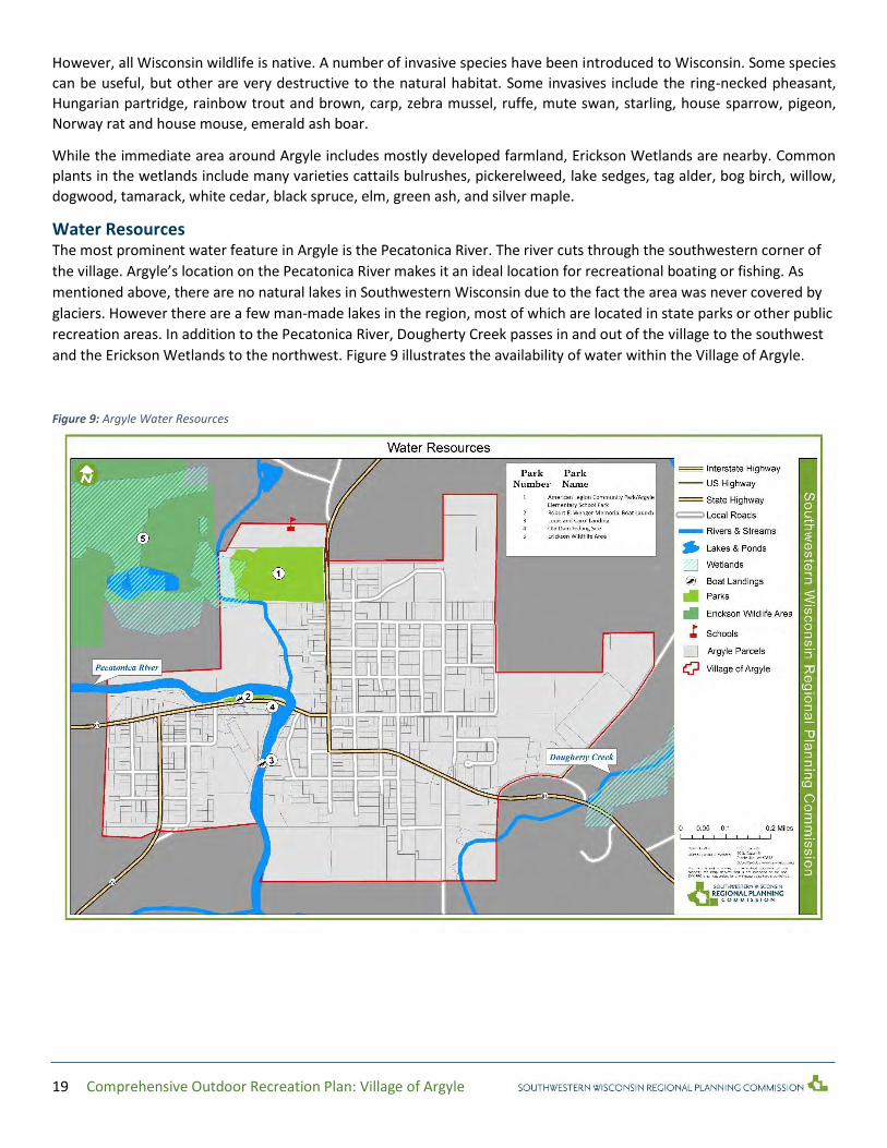
Water Resources The most prominent water feature in Argyle is the Pecatonica River. The river cuts through the southwestern corner of
the village. Argyle’s location on the Pecatonica River makes it an ideal location for recreational boating or fishing. As
mentioned above, there are no natural lakes in Southwestern Wisconsin due to the fact the area was never covered by
glaciers. However there are a few man-made lakes in the region, most of which are located in state parks or other public
recreation areas. In addition to the Pecatonica River, Dougherty Creek passes in and out of the village to the southwest
and the Erickson Wetlands to the northwest. Figure 9 illustrates the availability of water within the Village of Argyle.
Figure 9: Argyle Water Resources

20 Comprehensive Outdoor Recreation Plan: Village of Argyle
Outdoor Recreation Supply Inventory To determine what course of action village officials must take to provide a comprehensive recreation program, it is
necessary to evaluate the effectiveness of existing areas and facilities in meeting demands for recreation. This section of
the report provides an inventory of Argyle’s recreational facilities. The location of all park and recreation areas is recorded
on Figure 5.
The Village of Argyle has four village-owned developed recreation areas. The following is a short description and inventory
of existing village-owned park assets, community assets utilized for recreation, and potential assets for future recreation.
American Legion Community Park/Argyle Elementary School Park Located on the north side of the village along State Highway 78, the park was developed in the late 1940s through the
efforts of the American Legion. Now operated and maintained by the village. In 1993, through a cooperative effort
between the village and Argyle School District, new playground equipment was installed in the park. New lighted
basketball courts were added just south of the school, located next to the park. Additionally, American Legion Community
Park features a refurbished F-86H Saberjet.
Argyle Elementary School Park is located behind the Argyle school campus along State Highway 78 on the north side of
the village. This playground, which is adjacent to Argyle Legion Community Park
Classification: Community Park
14 Acres/.75 Acres
Landscaped
Refurbished F-86H Saberjet
26 Picnic tables
3 Benches
3 Shelters
3 Drinking fountains
13 Trash cans
7 Recycling bins
2 Restrooms (1 Handicap accessible)
4 Concession stands
2 Playground apparatuses with woodchip bases
1 Swing set
Sandbox with shovel machine
1 Nature observation deck
2 Half basketball courts
1 Football field
1 Baseball field
2 Softball fields
8 Mud volleyball fields
1 Children’s baseball/softball field
Robert E. Wenger Memorial Boat Launch The village operates a small park and boat launch/landing on the East Branch of the Pecatonica River along State
Highway 81 and just west of the bridge. This launch affords numerous opportunities for fishing, boating, and
canoeing. Many area residents enjoy canoeing from “Thunder Bridge” along Old Q Road north of Argyle. The boat
launch also offers a small covered shelter house with some picnic tables; the spot is ideal for a pre or post trip
snack or refreshments.
Classification: Special Use
.5 Acres
Landscaped
2 Picnic tables
1 Trash Can
1 Open space
1 Boat Ramp

21 Comprehensive Outdoor Recreation Plan: Village of Argyle
Old Dam Fishing Site
Only remnants of the dam now remain in the waters of the Pecatonica River, but the site continues to be a fishing hot
spot, especially during the spring walleye run. The fishing site draws anglers from throughout the tristate region in pursuit
of northern pike, muskellunge, and catfish.
Classification: Special Use
.32 Acres
Landscaped
2 Picnic tables
1 Trashcan
Louis and Carol Landing The Village of Argyle has utilized the Louis and Carol landing to allow more users to access the river. This boat launch is
more handicap accessible than the Robert E. Wenger Memorial Boat Launch.
Classification: Special Use
76 Acres
Landscaped
1 Trash can
1 Boat ramp
1 Fishing sit
Other Recreation Areas In addition to the previously mentioned developed areas for recreation, Argyle also has immediate access to the Erickson
Wetlands, owned by the Driftless Area Land Conservancy. This large, preserved wetland area is accessible through a
walking path on the western edge of American Legion Community Park. Additionally, Argyle also has access to an
approximate 1 acre area near the water tower that could easily become a neighborhood park. The advantage of this
location is that it already has handicap accessible sidewalks and that it is in the middle of a neighborhood and is
immediately accessible to residents.

22 Comprehensive Outdoor Recreation Plan: Village of Argyle
Outdoor Recreation Needs Assessment To compose the Outdoor Recreation Needs Assessment, SWWRPC developed a comprehensive outreach strategy for the
Village of Argyle. A survey was distributed online to various groups and organizations throughout Argyle including the
Argyle School District, and placed in print in key locations throughout the village including village hall, the post office, the
senior center, library, and health clinic. In total, SWWRPC collected 177 completed surveys with an estimated 20% sample
size of the total population.
These survey results were compiled, distributed, and presented in a public forum with the Argyle Parks Board on January
29, 2015. The results of the survey, public forum, and on-site evaluation for SWWRPC’s inventory process were
instrumental in framing the Outdoor Recreation Needs Assessment.
Survey The two primary purposes of the survey effort were to (1) identify the quality of existing parks, facilities, and recreation
spaces, (2) identify the need for future parks, facilities, and recreational spaces. Overall, park satisfaction in Argyle is
considered neutral. Most survey takers indicated that they were neither satisfied nor unsatisfied with Argyle parks, as
referenced in Figure 10. Figure 11 shows park frequency, and Figure 12 shows park satisfaction. Argyle School Playground
and Legion Park are the most visited and the highest rated, however the playground was indicated as “needing
improvement.” The other recreation locations; Robert E. Wenger Memorial Boat Launch, Louis and Carol Landing, and Old
Dam Fishing Site have low attendance.
Figure 10: Argyle’s Parks Satisfaction
0
10
20
30
40
50
60
70
Very Satisfied Somewhat Satisfied Neutral SomewhatDissatisfied
Very Dissatisfied Do not visit
Argyle Overall Parks Satisfaction

23 Comprehensive Outdoor Recreation Plan: Village of Argyle
Figure 11: Argyle Park Frequency
Figure 12: Argyle Park Satisfaction
In terms of addressing future needs, survey participants indicated their top-5 highest priorities for outdoor recreation.
These priorities are winter sports, walking/biking pathways, motorized vehicle trails, sports complexes, and community
gardens. Of these five priorities winter sports, pathways, motorized vehicle trails, and sport complexes were indicated as
being “needed now,” rather than sometime within the next five years. However, the majority of comments were about
improving existing park equipment and facilities. Survey participants had the following comments:
0
10
20
30
40
50
60
70
80
Argyle SchoolPlayground
American LegionCommunity Park
Argyle Boat Launch Old Dam Fishing Site Second Boat Launch
Park Frequency
Often Sometimes Neutral Rarely Almost Never
0
10
20
30
40
50
60
70
80
American LegionCommunity Park
Argyle SchoolPlayground
Old Dam Fishing Site Argyle Boat Launch Second Boat Launch
Park Satisfaction
Excellent Good Acceptable Needs Improvement Unacceptable

24 Comprehensive Outdoor Recreation Plan: Village of Argyle
“Argyle needs to get more activities. Argyle needs a pool and a walking/biking trail. Argyle needs a pool
because kids would have things to do if they are bored. The pool needs to be a[n] inside/outside pool. We
need a walking/biking trail because kids need to get exercise instead of sitting inside and playing video
games.”
“Maybe a turf would help for football. Also a few more biking trails and walking trails would be nice. I
think that we need a few more trees in the park. Maybe a better playground.”
“I think it would be wonderful to have walking/biking paths”
“It would be amazing to do a tracks-to-trails and convert old railways into bike trails, possibly leading up
to Sugar River trails. We need to provide safe bike ways on roads and market Argyle to bikers who go to
New Glarus, Paoli etc. but don’t make it out this far.”
“NEED Motorized Vehicle Tails NOW.”
“Playground could use more activities”
“The American Legion Community Park needs a lot. It needs more and new equipment. It needs restrooms
or just take care of the existing ones. Also the whole park needs to be taken care of better.”
“Better equipment”
“They need to have more stuff for the older kids so they will get off their phones and videogames and go
outside”
“Playground could use more activities.”
“We should get more playing equipment. We should get monkey bars.”

25 Comprehensive Outdoor Recreation Plan: Village of Argyle
Figure 13: Argyle Future Priorities
Public Forum At the public meeting, data gathered from the surveys and from the SWWRPC was shared with the Parks Board and the
public. The Parks Board reviewed the material, identified Argyle’s critical issues, provided additional feedback on the
survey, reviewed recommendations by park, and developed plan goals and actions.
One additional critical issue identified in this meeting was that, while Argyle has a lot of parks, access to village parks are
limited by existing infrastructure. For instance, the majority of Argyle is within walking distance of a park. However, the
northwest portion of the village does not have direct walking access to a park. The closest recreational facility that could
be used without crossing a major roadway is the “Argyle Youth Center,” however it is not currently in operation. A
potential site to remedy this issue would be where the water tower is located, in the northeast corner of the village.
Needs identified through public participation:
Priorities for park maintenance should be: restroom maintenance, improving amenities, increasing efforts like
landscaping and beautification, as well as facility maintenance
A new park is needed in the northeast corner of the village at the current water tower site
Park attendance needs to be improved
Argyle and regional residents need to know about existing opportunities to the natural environment like
Erickson Wetlands
Argyle residents need more opportunities to interact with nearby undeveloped natural assets
Argyle residents need more walking and biking opportunities
Argyle residents need access to winter recreational activities
0
10
20
30
40
50
60
70
80
Winter Sports(Skiing, Sleddin
Walking/BikingPathways
Motorized VehicleTrails
Sport Complexes(Baseball Fields,Softball Fields,
Volleyball Courts,Soccer Fields,
Basketball Courts,etc..)
Community Garden Dog Park
Future Priorities
Needed Now Needed Soon/ Within 5 years Needed Someday/ 5 years or more Not Needed

26 Comprehensive Outdoor Recreation Plan: Village of Argyle
Parks need to continue to be updated to become more handicap accessible
Parks need regular equipment and maintenance improvements
Continual funding is critical for the existing and future needs of the Argyle Parks system
Argyle can benefit from linking up with a regional motorized trail system

27 Comprehensive Outdoor Recreation Plan: Village of Argyle
Statewide Comprehensive Outdoor Recreation Plan
The 2011-2016 Wisconsin Statewide Comprehensive Outdoor Recreation Plan (SCORP), focused on a number of initiatives
to address the needs of outdoor recreation in Wisconsin. This plan focused primarily on outdoor recreation as related to
health, urban recreation, and open space conservation.
The plan indicated that access to outdoor recreation is an important predictor of community health and wellness. Parks,
trails, and sports facilities provide convenient, safe, and attractive spaces for people to get outside. Time spent outdoors
is associated with a number of important health factors, including improved mental health, more connected communities,
and more active citizens. In particular, there is increasing evidence that improving access to outdoor recreation can lower
obesity levels. Furthermore, these benefits are more difficult for people living in urban environments. While this is a valid
concern for individuals living in urban environments, in communities like Argyle access to the natural environment is a lot
simpler. Lastly, conservation in any state is difficult and becoming more challenging with fewer resources. The SCORP
indicates that state and local level conservation can be made possible through a number of strategies through public
private partnerships and intergovernmental coordination.
SCORP goals include:
Assess, Understand, and Adapt to Growing Recreation Tourism Demands and Preferences
Improve Integration of Outdoor Recreation Interests and Needs in Land Use and Other Relevant Planning Efforts
Continue to Provide and Enhance Public Access to Wisconsin Recreational Lands and Waters
Conserve Rural Landscapes and Forests through Partnerships and Incentives
Address Funding Challenges Associated with Managing Wisconsin Outdoor Recreation Resources
Promote Outdoor Recreation as a Means of Improving Public Health Among Wisconsinites
Establish Great Urban Parks and Community Green Spaces
“Every five years, Wisconsin publishes a Statewide Comprehensive Outdoor Recreation Plan (SCORP) as required by the Federal Land and
Water Conservation Fund (LWCF) Act of 1965. At its core, the document is used to help allocate federal funds equitably among local
communities, but the document also transcends many levels of outdoor recreation discussion and policy. At the nation level, this SCORP
recognizes the America’s Great Outdoors (AGO) initiative is based on the idea that the protection of the country’s natural heritage is a non-
partisan objective shared by all Americans.” – Wisconsin Statewide Outdoor Recreation Plan
28 Comprehensive Outdoor Recreation Plan: Village of Argyle
Recommendations for Outdoor Recreation
Action Program Even though Argyle is a small community, it has a great need of additional park space. Under the current park and open
space classification system, Argyle has enough open space for its population of 857 people. However, accessibility to the
existing community parks is limited by the highways that dissect Argyle. Currently, only half of the village is able to safely
walk to a village park. The following section features two sets of recommendations 1) to strengthen existing park assets
though ongoing maintenance improvements and by providing additional park amenities 2) to strategically acquire
additional park space to allow for the needs of existing Argyle residents while anticipating their needs for the future.
Recommendations by Park
American Legion Community Park/Argyle Elementary School Park
Bike racks should be installed next to playgrounds and kids ball fields. Clear signage should be available near the road to indicate access to Erickson Wetlands. Additionally, data received from the survey and from the on-site park inventory indicated that some recreational equipment should be updated.
Erickson Wetlands, Land Conservancy Trail Trail maintenance and possibly completion is needed. Signage should be available along the trail for both navigation and learning opportunities (i.e. local flora and fauna). The trail should be expanded and made to be handicap accessible. Additionally, finding the trail is difficult, more signage can be helpful in guiding visitors. Signage should start from the highway to direct traffic through American Legion Community Park.
Louis and Carol Landing A picnic table and benches could be added to the ADA fishing site. Additionally, the boat launch could be improved by paving or graveling the launch. Currently it is dirt and mud. Land next to the launch and fishing area could be developed into additional bank fishing spots with benches, picnic tables, and parking. Old Dam Fishing Site Benches or picnic tables could be added to the fishing pier. Open space south of the fishing site could be developed into a riverside park with benches, picnic tables and shore fishing opportunities.
Robert E. Wenger Memorial Boat Launch Handicap-accessible fishing benches should be added along the shoreline. Also a picnic table or two should be added with some recycling bins.
Addition of Recreation Spaces The water tower lot located on the corner of North St. and Breeze Terrace could be developed into a small park. This
location is critical in expanding recreational access to all of Argyle and there are no recreational assets on the east side of
the village. Additionally an undeveloped lot located on the corner of Grant and N. Lafayette Street could be developed
into a mini or neighborhood park.
Other additional recreation spaces include:
Adding a less-steep boat ramp on the southern branch of the Pecatonica River to provide easier access to the
shallow portion of the river.
A recreational vehicle campsite on the river near the Old Dam Fishing Site and the Argyle Boat Launch could be a
major asset as motorized trails expand though the county and the region.

29 Comprehensive Outdoor Recreation Plan: Village of Argyle
A walking trail along the southern bank of the Pecatonica River, linking the Robert E. Wenger Memorial Boat
Launch, The Old Dam Fishing Site, and the Louis and Carol Landing
Capital Improvement Schedule
Over the next five years, the Village of Argyle will focus on the improvements outlined in the previous section. These
recommendations are in addition to the standard operations and maintenance schedule that the village currently operates
under. A full copy of the Capital Improvement Schedule with priorities, cost, and timeline estimates can be found in
Appendix A. The highest priority outlined in the Capital Improvement Schedule are the addition of a park on the water
tower site, which is expected to be completed within the first year of plan implementation. The next highest priorities are
many of the park-specific recommendations as well as the expansion of the Erickson Wetlands Trail.
Table 3: Park Improvement Timeline
Year Park Recommendation
1
N/A Add a park on the water tower site
American Legion Community Park Add bike racks next to the playground and kickball fields
Add signage to clearly indicate access to Erickson Wetlands
2
N/A Add a walking trail on the Pecatonica River
Old Dam Fishing Site Add benches and/or picnic table to the fishing pier
Add benches or/or picnic tables to the shore near the pier
3
Louis and Carol Landing
Add picnic table to the ADA fishing site
Improve access to the landing by paving or graveling the path/parking lot
Add additional picnic tables and benches to land near the landing
Robert E. Wenger Memorial Boat Launch
Add handicap accessible fishing benches along shoreline
Add picnic table
Add recycling bins
4 - 5
N/A Add a park on the corner of Grant and N. Lafayette Street
Erickson Wetlands Upgrade/Expand trail to make it handicap accessible
Create signage along trail

30 Comprehensive Outdoor Recreation Plan: Village of Argyle
Appendix A: Capital Improvement Schedule
Table 4 - Capital Improvement Schedule
Park/Recommendation Cost Estimate Funding Source Priority Timeline
GF = General Fund DALC = Driftless Area Land Conservancy DNR = Department of Natural Resources
1 - 5 1 being highest priority
Within 1 year 2 years 3 years 4 years 5 years
Robert E. Wenger Memorial Boat Launch
Add handicap accessible fishing benches along shoreline $ 3,000.00 GF 3 Within 3 years Add picnic table $ 400.00 GF 3 Within 3 years Add recycling bins $ 300.00 GF 3 Within 3 years
Total: $ 3,700.00
Legion Park
Add bike racks next to the playground and kickball fields $ 500.00 GF 4 Within 1 year Add signage to clearly indicate access to Erickson Wetlands $ 800.00 GF, DALC, DNR 2 Within 1 year
Total: $ 1,300.00
Erickson Wetlands, Land Conservancy Trail
Upgrade/Expand trail to make it handicap accessible $ 120,000.00 DALC, DNR 2 Within 5 years Create signage along trail $ 5,000.00 DALC, DNR 2 Within 5 years
Total: $ 125,000.00
Old Dam Fishing Site
Add benches and/or picnic table to the fishing pier $ 1,000.00 GF 2 Within 2 years Add benches or/or picnic tables to the shore near the pier $ 1,000.00 GF 2 Within 2 years
Total: $ 2,000.00
Louis and Carol Landing
Add picnic table to the ADA fishing site $ 400.00 GF 2 Within 3 years Improve access to the landing by paving or graveling the path/parking lot $ 5,000.00 GF 2 Within 3 years Add additional picnic tables and benches to land near the landing $ 1,000.00 GF 2 Within 3 years
Total: $ 6,400.00
Additional Rec Spaces
Add a park on the water tower site $ 40,000.00 GF, DNR 1 Within 1 years Add a park on the corner of Grant and N. Lafayette Street $ 50,000.00 GF, DNR 5 Within 5 years Add a walking trail on the Pecatonica River $ 10,000.00 2 Within 2 years
Total: $ 100,000.00
Total: $ 238,400.00

31 Comprehensive Outdoor Recreation Plan: Village of Argyle
Appendix B: Maps