Communication and Community Shelter Networks: Smarter Stay Smarter Go
4
Decison: Stay or Go Stay Stay - definately Go The ‘Stay or Go’ group -undecideds EARLY: DAY(S) BEFORE ON THE DAY HOUR BEFORE FIRE PERIOD Leave rural area to city or low-risk zone Bushfire Stay or Go - a decision chart Into Shelters; either -House based (private bunkers) -Road based (bus/fire shelter) -Town based (big shelter) Use fire pole to direct effectice exit Go take shelter in roadside bus/fire shelter whislt trying to escape Use fire pole to establish fire danger in coming days STRATEGY BEHAVIOUR Kinglake after the 7 Feb 2009 Fires. Image: Australian Defence Force Cross disciplinary team of designers and makers: Jacqui Edge, Stuart Harrison, Marcus White, Rory Fort, Travis Dean, Luke Adams and Matt Tonner’s house (top) before and after the fires. Working on different scales of house, road and town. Area of fire damage from Feb7/Black Saturday is roughly the same area of, and very close to, metropolitan Melbourne. Improving and making networks of communication, information and shelter Looking at existing communication for fires and emergencies and looking for opportunies to improve and make real time. Dual-functioning: seeing how other forms of infrastructure shelters, in this case those for public transport can be used as part of a new system.\\\\\\\\\c\ Smarter Stay Smarter Go is a system of communication and community shelter networks that aims to provide survival options for rural residents and visitors in the times of bushfires. To make a smarter ‘Go’ decision, we propose a new communication network to provide real-time data on current weather conditions to all stake holders provides real time fire risk communication for the public through a network of new fire danger index signs, replacements for the ‘Fire Danger Today’ signs that have been superseded by the new fire danger classification system. This would form part of a new data distribution system, open for all to access, forming an improved data collection network that would augment existing information gathering. We aim to provide a secure ‘Stay’ option, by encouraging the use of community-based fire shelters that are located within housing clusters, in or around towns. This strategy recognises that much rural living is still neighbourhood-based. Isolated property owners would install their own fire shelters, and this is the focus of the current marketplace. Our research to date has developed a roadside community shelter that works a bus shelter in non-emergency times. We have a project-wide approach of ‘dual-functioning’ to increase investment efficiency and provide on-going maintenance and testing through local use. We recognise the difficultly in assuming behavioural responses to emergency situations, and seek to provide options for all decisions, those who stay, those who go and those who continue to defer the decision until the last moment. The diagram below shows the time-based decisions relating to stay or going and how our devices assist all options.
-
Upload
rmit-architecture -
Category
Documents
-
view
217 -
download
2
description
Shortlisted competition entry for Design Challenge 09: Fire, organised by the RMIT Design Research Institute. CCSN Team: Luke Adams, Travis Dean, Jacqueline Edge, Rory Fort, Stuart Harrison (RMIT Architecture) and Matt Tonner, Marcus White (RMIT Architecture).
Transcript of Communication and Community Shelter Networks: Smarter Stay Smarter Go

Decison:Stay or Go
Stay
Stay -definately
Go
The ‘Stay or Go’ group-undecideds
EARLY: DAY(S) BEFORE
ON THE DAY
HOUR BEFORE
FIRE PERIOD
Leave rural area to city or low-risk zone
Bushfire Stay or Go - a decision chart
Into Shelters; either-House based(private bunkers)-Road based(bus/fire shelter)-Town based(big shelter)
Use fire poleto direct effecticeexit
Go
take shelter in roadsidebus/fireshelterwhislt trying to escape
Use fire poleto establish fire dangerin coming days
STRATEGY BEHAVIOUR
Kinglake after the 7 Feb 2009 Fires. Image: Australian Defence Force
Cross disciplinary team of designers and makers: Jacqui Edge, Stuart Harrison, Marcus White, Rory Fort, Travis Dean, Luke Adams and Matt Tonner’s house (top) before and after the fires.
Working on different scales of house, road and town. Area of fire damage from Feb7/Black Saturday is roughly the same area of, and very close to, metropolitan Melbourne.
Improving and making networks of communication, information and shelter
Looking at existing communication for fires and emergencies and looking for opportunies to improve and make real time.
Dual-functioning: seeing how other forms of infrastructure shelters, in this case those for public transport can be used as part of a new system.\\\\\\\\\c\
Smarter Stay Smarter Go is a system of communication and community shelter networks that aims to provide survival options for rural residents and visitors in the times of bushfires.
To make a smarter ‘Go’ decision, we propose a new communication network to provide real-time data on current weather conditions to all stake holders provides real time fire risk communication for the public through a network of new fire danger index signs, replacements for the ‘Fire Danger Today’ signs that have been superseded by the new fire danger classification system. This would form part of a new data distribution system, open for all to access, forming an improved data collection network that would augment existing information gathering.
We aim to provide a secure ‘Stay’ option, by encouraging the use of community-based fire shelters that are located within housing clusters, in or around towns. This strategy recognises that much rural living is still neighbourhood-based. Isolated property owners would install their own fire shelters, and this is the focus of the current marketplace. Our research to date has developed a roadside community shelter that works a bus shelter in non-emergency times. We have a project-wide approach of ‘dual-functioning’ to increase investment efficiency and provide on-going maintenance and testing through local use.
We recognise the difficultly in assuming behavioural responses to emergency situations, and seek to provide options for all decisions, those who stay, those who go and those who continue to defer the decision until the last moment. The diagram below shows the time-based decisions relating to stay or going and how our devices assist all options.
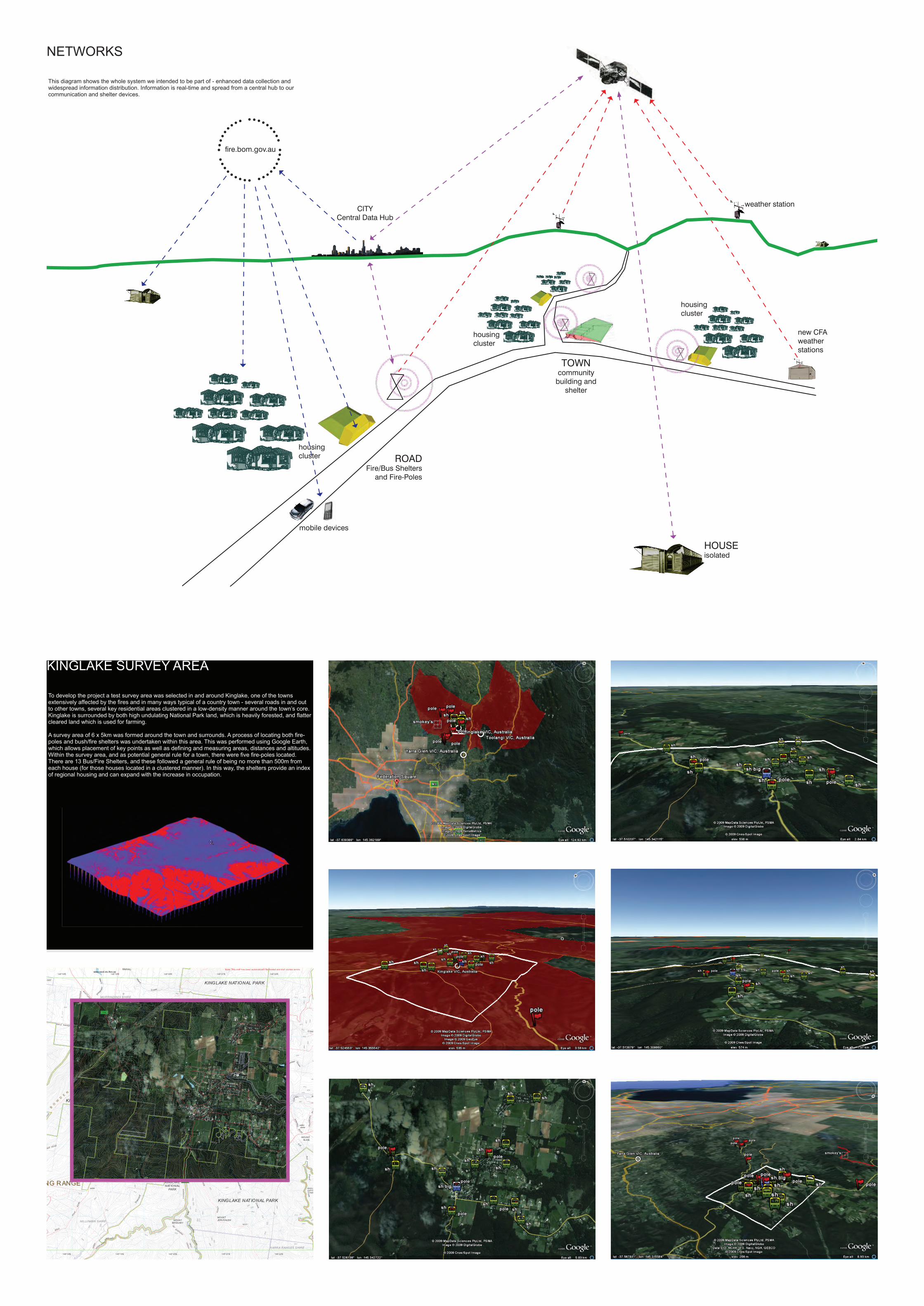
NETWORKS
fire.bom.gov.au
CITYCentral Data Hub
TOWNcommunity
building and shelter
ROADFire/Bus Shelters
and Fire-Poles
mobile devices
housing cluster
housing cluster
housing cluster
weather station
new CFA weather stations
HOUSEisolated
This diagram shows the whole system we intended to be part of - enhanced data collection and widespread information distribution. Information is real-time and spread from a central hub to our communication and shelter devices.
To develop the project a test survey area was selected in and around Kinglake, one of the towns extensively affected by the fires and in many ways typical of a country town - several roads in and out to other towns, several key residential areas clustered in a low-density manner around the town’s core. Kinglake is surrounded by both high undulating National Park land, which is heavily forested, and flatter cleared land which is used for farming.
A survey area of 6 x 5km was formed around the town and surrounds. A process of locating both fire-poles and bush/fire shelters was undertaken within this area. This was performed using Google Earth, which allows placement of key points as well as defining and measuring areas, distances and altitudes.Within the survey area, and as potential general rule for a town, there were five fire-poles located. There are 13 Bus/Fire Shelters, and these followed a general rule of being no more than 500m from each house (for those houses located in a clustered manner). In this way, the shelters provide an index of regional housing and can expand with the increase in occupation.
KINGLAKE SURVEY AREA
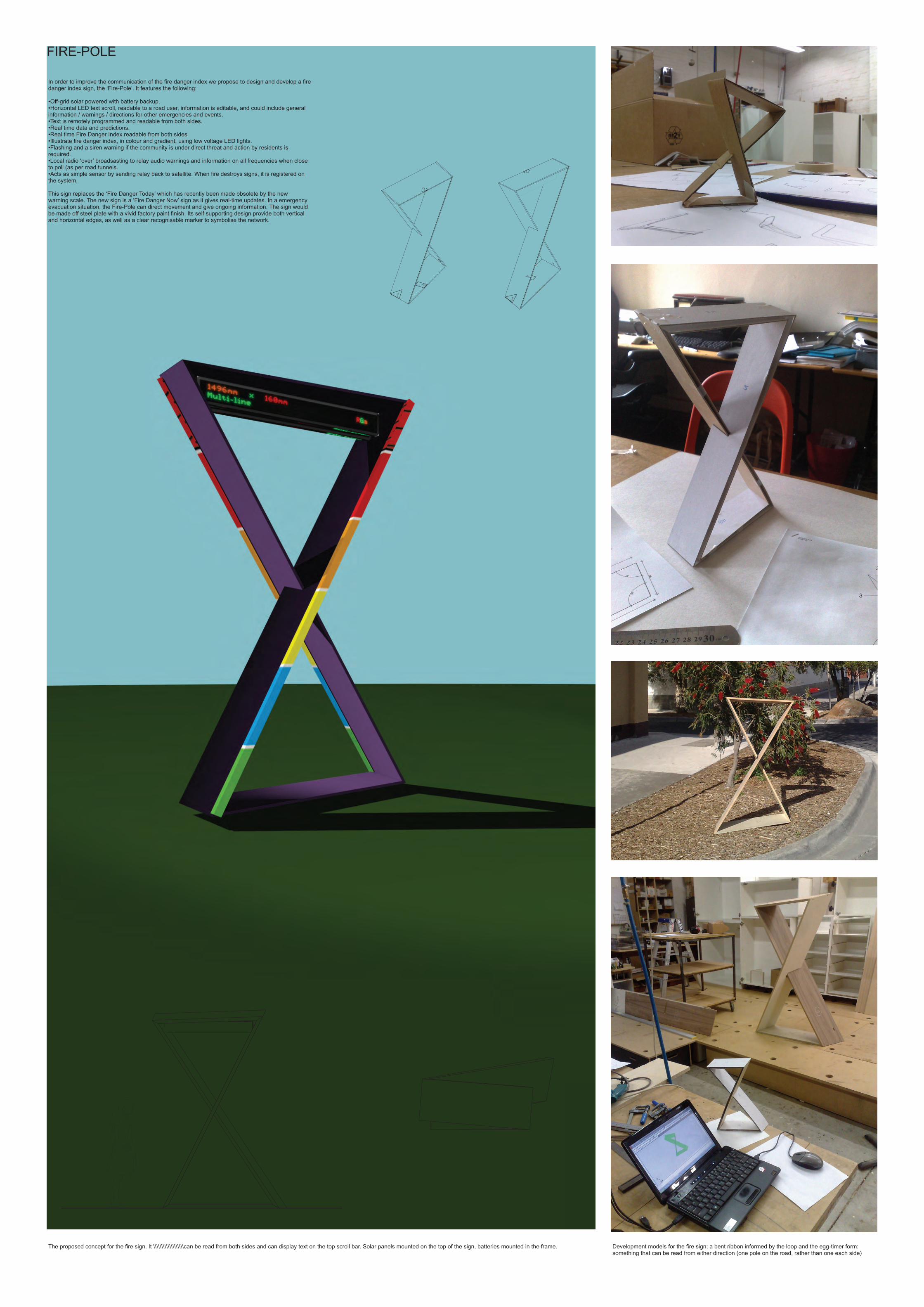
FIRE-POLE
Development models for the fire sign; a bent ribbon informed by the loop and the egg-timer form: something that can be read from either direction (one pole on the road, rather than one each side)
In order to improve the communication of the fire danger index we propose to design and develop a fire danger index sign, the ‘Fire-Pole’. It features the following:
•Off-grid solar powered with battery backup.•Horizontal LED text scroll, readable to a road user, information is editable, and could include general information / warnings / directions for other emergencies and events.•Text is remotely programmed and readable from both sides.•Real time data and predictions.•Real time Fire Danger Index readable from both sides•Illustrate fire danger index, in colour and gradient, using low voltage LED lights.•Flashing and a siren warning if the community is under direct threat and action by residents is required.•Local radio ‘over’ broadsasting to relay audio warnings and information on all frequencies when close to poll (as per road tunnels.•Acts as simple sensor by sending relay back to satellite. When fire destroys signs, it is registered on the system.
This sign replaces the ‘Fire Danger Today’ which has recently been made obsolete by the new warning scale. The new sign is a ‘Fire Danger Now’ sign as it gives real-time updates. In a emergency evacuation situation, the Fire-Pole can direct movement and give ongoing information. The sign would be made off steel plate with a vivid factory paint finish. Its self supporting design provide both vertical and horizontal edges, as well as a clear recognisable marker to symbolise the network.
The proposed concept for the fire sign. It \\\\\\\\\\\\\\\\\\\can be read from both sides and can display text on the top scroll bar. Solar panels mounted on the top of the sign, batteries mounted in the frame.
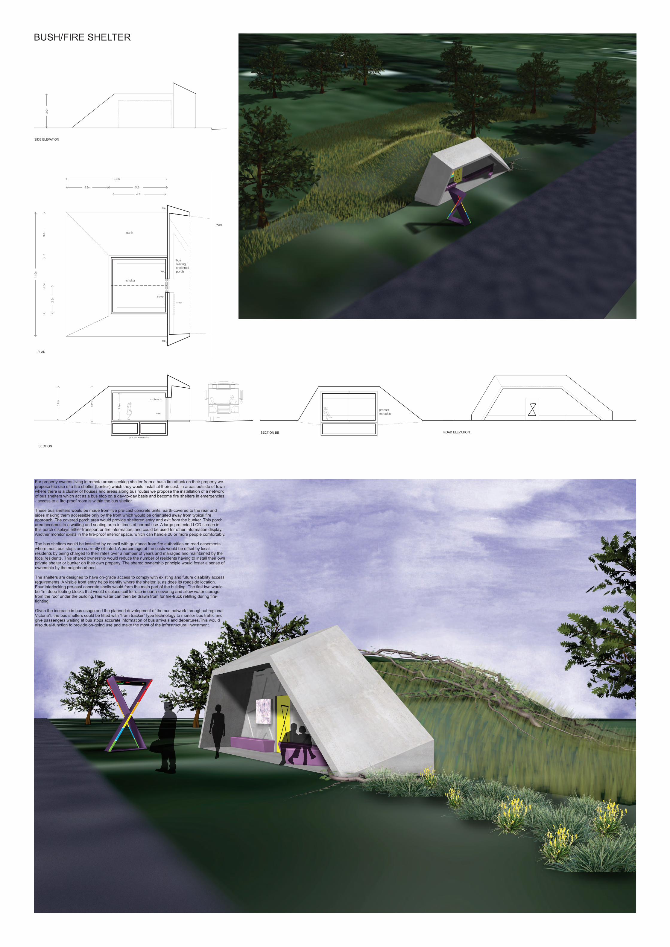
BUSH/FIRE SHELTER
For property owners living in remote areas seeking shelter from a bush fire attack on their property we propose the use of a fire shelter (bunker) which they would install at their cost. In areas outside of town where there is a cluster of houses and areas along bus routes we propose the installation of a network of bus shelters which act as a bus stop on a day-to-day basis and become fire shelters in emergencies - access to a fire-proof room is within the bus shelter.
These bus shelters would be made from five pre-cast concrete units, earth-covered to the rear and sides making them accessible only by the front which would be orientated away from typical fire approach. The covered porch area would provide sheltered entry and exit from the bunker. This porch area becomes to a waiting and seating area in times of normal use. A large protected LCD screen in this porch displays either transport or fire information, and could be used for other information display. Another monitor exists in the fire-proof interior space, which can handle 20 or more people comfortably.
The bus shelters would be installed by council with guidance from fire authorities on road easements where most bus stops are currently situated. A percentage of the costs would be offset by local residents by being charged to their rates over a number of years and managed and maintained by the local residents. This shared ownership would reduce the number of residents having to install their own private shelter or bunker on their own property. The shared ownership principle would foster a sense of ownership by the neighbourhood.
The shelters are designed to have on-grade access to comply with existing and future disability access requirements. A visible front entry helps identify where the shelter is, as does its roadside location.Four interlocking pre-cast concrete shells would form the main part of the building. The first two would be 1m deep footing blocks that would displace soil for use in earth-covering and allow water storage from the roof under the building.This water can then be drawn from for fire-truck refilling during fire-fighting.
Given the increase in bus usage and the planned development of the bus network throughout regional Victoria1, the bus shelters could be fitted with “tram tracker” type technology to monitor bus traffic and give passengers waiting at bus stops accurate information of bus arrivals and departures.This would also dual-function to provide on-going use and make the most of the infrastructural investment.