COMAL APPRAISAL DISTRICT OPEN SPACE … SPACE GUIDELINES...OPEN SPACE GUIDELINES & STANDARDS TABLE...
22
1 COMAL APPRAISAL DISTRICT OPEN SPACE GUIDELINES & STANDARDS
Transcript of COMAL APPRAISAL DISTRICT OPEN SPACE … SPACE GUIDELINES...OPEN SPACE GUIDELINES & STANDARDS TABLE...
1
COMAL APPRAISAL DISTRICT
OPEN SPACE GUIDELINES &
STANDARDS
2
OPEN SPACE GUIDELINES & STANDARDS
TABLE OF CONTENTS
I. Introduction ………………………………………………………………………........ 3
II. Definitions ……………………………………………………........................................3
III. Standards…..……………………………………………………………………………7
Historical Use
Current Use
Principle Use
Degree of Intensity
IV. Procedures ………………..……………………………………………………….…..10
Applications
Surveys
Leases
Confidentiality Policy
Field Inspections
Determination
Quality Control
Rollback
V. Types of Agricultural Use Operations……………………………………………….14
Livestock Operation
Exotic Operation
Beekeeping Operation
Crop Land Operation
Orchard
Vineyard
Government Program
Ecological Laboratory
Wildlife Management
VI. Land Types .……………………………………..………………………………….....20
Description of Classes
Land Type Codes
Productivity Schedules
VII. Agricultural Advisory Board…………………………………………........................22
These guidelines were reviewed and updated by the Agricultural Advisory Board and the Comal
Appraisal District on September 26, 2017.
3
I. INTRODUCTION
The Comal Appraisal District is responsible for the administration of special valuation found in the
Texas Property Tax Code in Subchapter D, Sec. 23.41 through Sec. 23.60. The District has developed
guidelines for qualifying property as open space for special valuation. The District referred to the
following resource for guidance in establishing its guidelines:
Texas Property Tax Code
Texas Comptroller of Public Accounts
Texas Parks & Wildlife
United States Department of Agriculture
Comal County Agricultural Extension Services
Texas State & Soil Conservation Board
Comal Agricultural Advisory Board
Agricultural appraisal applies only to land. Only the acreage used in an agricultural operation may
qualify for agricultural use valuation. Land not qualifying for agricultural use is valued at market
value. Improvements are appraised separately at their market value. Farm and ranch machinery and
equipment (Implements of husbandry) used for agricultural production are exempt from ad valorem
taxation.
II. DEFINITIONS
Also includes definitions from the Texas Agriculture Code – Section 131.001 [TAgC-131.001]
Abandoned Apiary, Equipment, or Bees: means an apiary, equipment, or a
colony of bees that is not regularly maintained or attended in accordance with the
TAgC-131.001 or rules or quarantines adopted under that chapter.
Agricultural Operation - land operated by the producer with equipment, labor, management and
production practices that are substantially separate from other operations. (USDA)
Agricultural use includes but is not limited to the following activities:
- Cultivating the soil
- Producing crops for human or animal feed
- Planting seed for production of fiber
- Raising or keeping livestock
- Raising or keeping exotic animals for the production of human food or other tangible
products having commercial value
- Planting cover crops in conjunction with normal crop or livestock rotation
- Floriculture, viticulture, and horticulture

4
- Planting cover crops for the purpose of participating in government program
- Raise or keeping bees for pollination or production of human food
- Use of land for wildlife management
Animal Unit - used to represent the relationship of quantity of livestock and wildlife in terms of
weight. An animal unit equals 1000 lbs of live weight.
Apiary - means a place where six or more colonies of bees or nuclei of bees are kept. Also
known as a bee yard, is a place where beehives of honey bees are kept. Traditionally beekeepers
(also known as apiarists) paid land rent in honey for the use of small parcels. Some farmers will
provide free apiary sites, because they need pollination, and farmers who need many hives often
pay for them to be moved to the crops when they bloom.
Artificial Beehives - serves two purposes; production of honey and pollination of nearby crops.
Artificial hives are commonly transported so that bees can pollinate crops in other areas.
Bee - means any stage of the common honeybee, Apis mellifera species.
Beehive - an enclosed structure in which some honey bee species live and raise their young.
Natural beehives are naturally occurring structures occupied by honeybee colonies, while
domesticated honeybees live in man-made beehives, often in an apiary. These man-made
structures are typically referred to as “beehives.” Several species of Apis live in hives, but only
the western honey bee and the eastern honey bee are domesticated by humans.
Beekeeper - means a person who owns, leases, or manages one or more colonies of bees for
pollination or the production of honey, beeswax, or other by-products, either for personal or
commercial use.
Colony - means the hive and its equipment and appurtenances including bees, comb, honey,
pollen, and brood.
Crop - cultivated plant that is grown as food, especially a grain, fruit, or vegetable; an amount of
produce harvested at one time.
Cultivate – to prepare and use (land) for crops.
Disease - means American foulbrood, European foulbrood, any other contagious or infectious
disease of honeybees, or parasites or pests that affect bees or brood.
Equipment - the necessary items for a particular purpose. In reference to beekeeping means
hives, supers, frames, veils, gloves, tools, machines, or other devices for the handling and
manipulation of bees, honey, pollen, wax, or hives, including, storage or transporting containers
for pollen, honey, or wax, or other apiary supplies used in the operation of an apiary or honey
house.
5
Exotic animal means a species of game not indigenous to Texas.
Husbandry -the care, cultivation, and breeding of crops and animals.
Implements of Husbandry – Machinery and equipment items that are used in the production of farm
or ranch products; regardless of their primary design.
Improved Pasture –land planted with grasses that are not native to Comal County but suitable for
grazing animals.
Label - (as a noun) means written or printed material accompanying a product and furnishing
identification or a description. The term includes material attached to a product or its immediate
container and material inserted in an immediate container or other packaging of a product.
Label - (as a verb) means to attach or insert a label (as a noun).
Livestock – are domesticated animals that derive its primary nourishment from vegetation,
supplemented as necessary with commercial feed. Livestock includes meat or dairy cattle, horses,
goats, swine, poultry, and sheep.
Wild animals are not considered livestock. Miniature horses and miniature donkeys are not
considered qualifying agricultural livestock.
Miniature Donkey- Miniature donkeys are not considered qualifying agricultural livestock. They are
considered pets. Their height is up to 36 inches at the withers.
Miniature Horse- Miniature horses are not considered qualifying agricultural livestock. They are
considered pets. Their height is usually less than 34 to 36 inches as measured at the last hairs of the
mane, found at the withers.
Natural Beehive - comparable to a bird’s nest, built with a purpose to protect the dweller. The
beehive’s internal structure is a densely-packed matrix of hexagonal cells made of beeswax,
called a honeycomb. The bees use the cells to store food (honey and pollen) and to house the
“brood” (eggs, larvae, and pupae).
Native Pasture - land covered with grasses native to Comal County suitable for grazing animals.
Nucleus - means a small mass of bees and combs of brood used in forming a new colony.
Open-space - land that is currently devoted principally to agricultural use to the degree of intensity
generally accepted in the area and that has been devoted principally to agricultural use.
6
Pasture -land covered with grass and other low plants suitable for grazing animals, especially cattle or
sheep.
Pollen - means dust-like grains formed in the anthers of flowering plants in which the male
elements or sperm are produced.
Pollination - is the process by which pollen is transferred in the reproduction of plants, thereby
enabling fertilization and sexual reproduction.
Primary -of chief importance.
Principle -a fundamental quality or attribute determining the nature of something (Oxford dictionary).
Production of Human Food - (including but not limited to) honey, bee pollen, honey candies,
sweets.
Production of Products - (including but not limited to) candles, beeswax, soaps.
Production Value - production value will be established from one or more neighboring Appraisal
Districts with beekeeping operations until such a time that District can create production value
with local survey information from a statistically sound sampling.
Pure Honey - means the nectar of plants that has been transformed by, and is the natural product
of, bees and that is in the comb or has been taken from the comb and is packaged in a liquid,
crystallized, or granular form.
Queen Apiary - means an apiary in which queen bees are reared or kept for sale,
barter, or exchange. The hives are placed in groups in an open pasture. Only land directly under
and between the hives will qualify for 1-d-1 Open Space.
Typical – having the distinctive qualities of a particular type of person or thing (Oxford dictionary)
Use -the action of using something or the state of being used for some purpose (Oxford dictionary)
Vineyard - a plantation of grapevines, typically producing grapes used in winemaking
Orchard - a piece of land planted with fruit trees
Waste Land – land not suitable for production or grazing animals.

7
III. STANDARDS
The District must be able to determine that the property meets certain standards in order to qualify
under open space. The following criteria must be met for all qualifying open space land:
Historical Use
Current Use
Principle use
Degree of Intensity
HISTORICAL USE
The land must have been used principally for an agricultural use for five of the seven preceding years.
As long as agricultural was the principle use of the land in the preceding years, the land may qualify
even if historically the agricultural use did not meet the degree of intensity requirement for all or part
of those preceding years. Land may not be “used for residential purposes or a purpose inconsistent
with agricultural use.” (TPTC Sec. 23.51(2))
When historical use is in doubt, then the following may be used to verify:
IRS forms (Schedule F)
Livestock or Crop Sales receipts (as applicable)
Expense receipts
Valid and current lease agreements or sworn affidavits from lessor and lessee
Any other documentation that gives evidence of activity
Dated photographs
If the property is located within the boundaries of a city, then the land must have been devoted
principally to agricultural use continuously for the preceding five years.
CURRENT USE
The land must be in agricultural use as of January 1st of the year of the application to the degree of
intensity typical for the county. The burden of proof for eligibility rest with the owner/operator, if use
is not evident then the owner/operator must demonstrate the primary intent to utilize the principle use
of the land for Agricultural purposes for the principle part of the year.

8
PRINCIPLE USE
The land must be devoted principally to an agricultural use. There may be more than one use for land,
but the primary use must be agricultural. Any secondary uses should not conflict with the primary use
of the land.
Recreational Use
Hunting, horse boarding and/or training, and other similar uses will be considered a recreational use.
These uses may be performed on the land along with agricultural use. If no agricultural use exists on
the property, then the recreational use will be considered the principle use of the land.
Residential Use
When land has a residential improvement such as a residence or manufactured home, the District will
assign some land for residential use. The following are examples on how to determine the amount of
land that will be classified as residential:
1. If the residence has been surveyed with land less than an acre (usually for home equity
loans), then the District may use the amount specified in the survey.
2. If the property owner files a homestead application specifying up to 20 acres as their
homestead, then the District may use the amount specified in the application.
3. If no amount has been specified by the property owner, then the District may assign land
as residential use per field inspection. The appraiser shall determine if the area with a
residence has been fenced or “marked” by roads, bushes etc. The amount of land in this
area could be identified as residential use.
Non-Use
If land does not have a use that can be defined as agricultural, residential, commercial or recreational,
then the district will recognize it as not being in use or idle, and will not be eligible to be appraised at
the special use valuation (i.e.: the property is just a vacant tract of land and no activities are being
performed).
9
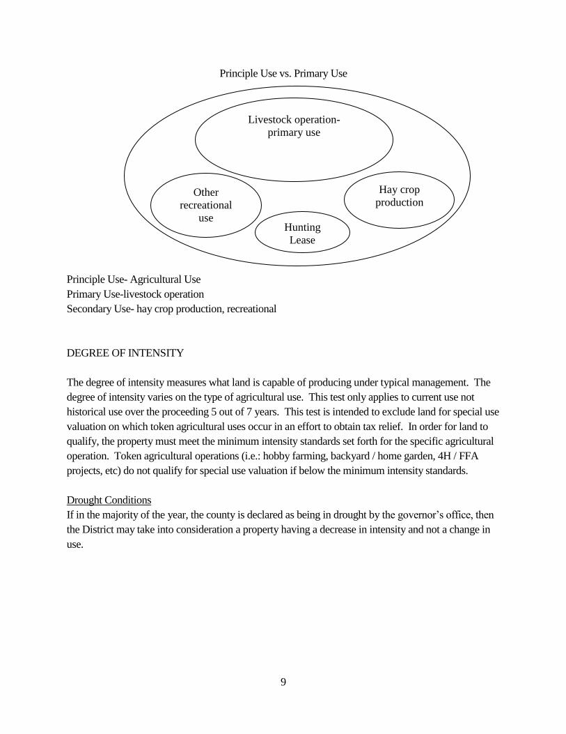
Principle Use vs. Primary Use
Principle Use- Agricultural Use
Primary Use-livestock operation
Secondary Use- hay crop production, recreational
DEGREE OF INTENSITY
The degree of intensity measures what land is capable of producing under typical management. The
degree of intensity varies on the type of agricultural use. This test only applies to current use not
historical use over the proceeding 5 out of 7 years. This test is intended to exclude land for special use
valuation on which token agricultural uses occur in an effort to obtain tax relief. In order for land to
qualify, the property must meet the minimum intensity standards set forth for the specific agricultural
operation. Token agricultural operations (i.e.: hobby farming, backyard / home garden, 4H / FFA
projects, etc) do not qualify for special use valuation if below the minimum intensity standards.
Drought Conditions
If in the majority of the year, the county is declared as being in drought by the governor’s office, then
the District may take into consideration a property having a decrease in intensity and not a change in
use.
Livestock operation-
primary use
Hay crop
production
Hunting
Lease
Other
recreational
use
10
Resting
The District requires a written notification for each year that the property will be rested. The
notification must be submitted each year no later than the April 30th application deadline. Excluding
drought proclamations by the governor’s office, a property may not be rested for more than 2 years
during a 7-year period.
The following are examples of resting:
- Letting property sit idle due to government program
- Rotating livestock to another pasture
- Improvements to land such as terracing, brush control
IV. PROCEDURES
Each year the District will notify all owners who will be required to reapply. The District requires a
reapplication for agricultural/wildlife valuation for the following reasons:
- the most recent application on file is ten or more years old
- the property appears to have a change in use
- the property had a change in acreage size
- the application had a change in ownership name
- by random selection
- the chief appraiser determines the need for a new application
Ten or more years old application
Each year the District shall identify all properties with an application that were filed 10 or more years
older than the reappraisal year. The District will only include those properties in its current reappraisal
area: RA1, RA2 or RA3. A list will be generated to include all of the properties with a state code of
D1 that meet the age test. The District will add a property group code of AGRMV
(ag/openspace/wildlife removal) to these accounts.
Change in use
Each year the District shall identify all properties that appear to have had a change in use or the owner
has notified the District of a change in use. The District will add a property group code of AGRMV
(ag/open-space/wildlife removal) to these accounts.
If a property owner fails to notify the District of a change in use, then the District shall impose a
penalty. In addition, if the property is idle for a greater period than allowed or no longer being used
for agricultural or wildlife use, the property is subject to a rollback penalty for any of the five previous
years that the property received special use valuation. A reduction of use below the minimum
intensity standards may not necessarily trigger a rollback penalty but may result in a loss of the special
use valuation.
11
Change in acreage size
Each year the District shall identify all properties that had a change in acreage size due to new survey,
sale or property split. The District will add a property group code of AGRMV (ag/openspace/wildlife
removal) to these accounts.
Change in ownership
Every January the District should verify that all deed recordings from the preceding year have been
updated in its CAMA system. A list will be generated to include all of the properties with a state code
of D1 that have had a change in ownership. The District will add a property group code of AGRMV
(ag/openspace/wildlife removal) to these accounts.
Properties which appear to have a change in use, acreage size or require a reapplication for any other
reason will also be included in this list. The AGRMV list will be used to generate letters. Each owner
will be sent a request to reapply for open space. The special valuation shall remain on the property
until the end of the year. If the owner fails to submit the requested information by the end of the year,
the agricultural valuation shall be removed from the property. Prior to February, the District shall
notify by certified mail all owners who had their agricultural and/or wildlife removed from their
property(s). The District’s correspondence will include the Ag Removal Letter, an application for 1-
D-1 Open Space or Wildlife, and the Supplement form to the application. When an Ag Removal
Letter is generated, an event will be created in each account recording a copy of the letter.
APPLICATIONS
The District uses the state approved application for 1-D-1 Open Space. The District also requires a
supplement to the application for 1-d-1 be submitted by the applicant. The District accepts
applications until April 30th of each year. Should April 30th fall on a Saturday or Sunday, then the
application deadline will be the following Monday. All applications filed between the April 30th
deadline and the date of the appraisal roll certification are considered late and will be assessed a 10%
penalty, if approved.
As applications are received, all applications and their attached documents shall by stamp dated.
All applications and attached documents should be forwarded to the special valuation appraiser
for review. The District may request additional documents, if necessary, in order to determine if
the property qualifies. The burden of proof to demonstrate eligibility rest with the owner.
All applications will be initially checked for the following:
- the application is signed
- the application identifies the property(s)
- all supporting documentations such as the supplemental form and leases are attached
- the application has correct information filled out
12
After the initial review, only the application should be scanned into the appropriate account(s). The
applications are then generally divided by regions and prepared for field inspections. Owners with
properties not previously receiving special use valuation must include a sufficient amount of
Historical Use evidence to allow staff to make a proper determination of Historical Use.
SURVEYS
The District has developed a supplemental form to gather lease information. These surveys are
always attached to all 1-d-1 applications. The supplemental forms are mailed out along with the open
space applications. All information acquired from these surveys is entered into excel spreadsheets.
The survey information is used to develop the net to land calculations and develop productivity
schedules.
LEASES
Leases are a contract by which one party conveys land, property, services, etc., to another for a
specified time, usually in return for a periodic payment. An owner applying for agricultural use
valuation using a lease agreement needs to include with the application a copy of the lease. The lease
should state the kind of agricultural use, the number of acres, the duration of the lease, names and
signatures of both parties.
If only an oral agreement exists between both parties, then the District will require a written statement
signed and notarized by both parties.
CONFIDENTIALITY POLICY
It is the Comal Appraisal District's policy that all reported revenue, leases, and any personal
information such as driver's license, social security numbers, etc. are to be treated as confidential.
This information is considered confidential regardless of the source or the lack of any verbal or
written agreement. This information will be kept with the applicant's file.
FIELD INSPECTIONS
The appraiser(s) shall review aerial imagery and/or drive to the properties to determine the
current and principle use. If the property cannot be clearly seen from the road, its use cannot be
clearly determined, or access to the property for additional information is needed, then an Ag
Inspection Letter will be sent to the owner and/or agent requesting access to the property.
Failure to comply may result in loss of special use valuation and/or rollback penalty.
During the field inspection, the appraiser should document any relevant information on the
agricultural field inspection checklist. Notes should be made about the condition of the soil,

13
fences or lack of, water source, crops, type and quantity of livestock, or other evidence of animal
activity. Routine and random field inspections of properties receiving special use valuation will
be performed by District staff to determine continued eligibility and compliance of minimum
intensity standards. If it is determined that an operation is not in compliance with minimum
intensity standards, a rollback penalty may be initiated.
DATA ENTRY
Certain information is required to be entered into PAC’s. The following fields must be
populated:
Images screen
- the application, supplement form, and field inspection form should be scanned
Appraiser Info screen
- Inspection date and appraiser name
- Ag field notes should be included in the comment field
The following are the standard notes that should be entered in the comment field:
- Ag Approved for 20XX
- Ag denied for 20XX
- Resting for 20XX per letter
- Started history as of 20XX per application
- Started history as of 20XX per documentation
Land screen
- The year the application is approved must be entered in the appraisal code field.
- The land types should match those documented in the field.
QUALITY CONTROL
The District will have the data fields listed above reviewed to ensure that the appropriate information
was entered into PAC’s.
A list will be generated on all properties that required a re-application but failed to reapply. This list
will be reviewed to ensure data entry was completed. The District may contact the owner(s) to answer
any questions.
DETERMINATION
The District will either grant or deny the agricultural or wildlife application. Once a
determination of use is established, then the District shall notify each applicant in writing of the

14
determination. If a property is granted the special valuation, then the District will apply the
appropriate land type codes, as well as the appropriate productivity schedule to all accounts that
qualified. A file will be created for all applications granted the special valuation. This file will
include all documents and correspondence to and from the applicant.
CHANGE OF USE AND ROLLBACK PENALTY
If land receiving agricultural valuation changes to a non-agricultural use, then a rollback tax may be
imposed. The rollback is a penalty imposed for taking the land out of agricultural use into another
use. The rollback is assessed based on the part of the land that had received productivity values for
the preceding five years. The rollback tax is the difference on taxes that would have been paid at
market value and actual taxes paid based on productivity value. The rollback also includes a
cumulative 7% annual interest penalty added to each of the preceding five years. An estimate of
rollback will be calculated only upon written request.
V. TYPES OF AGRICULTURAL USE OPERATIONS
The historical use and principle use tests apply to all properties. The degree of intensity varies from
each type of operation. The burden of proof to demonstrate eligibility rest with the owner. The
owner/operator must be able to demonstrate that an agricultural commodity is being produced:
- Livestock operations must produce meat, milk, or fiber;
- Crop operations must produce commodities and demonstrate crop yields;
- Hay operations must show hay is being cut and sold or used to feed operator owned livestock;
- Equine operations must be a breeding operation or horses must have a farm or ranch use.
There are various types of agricultural operations within Comal County. Many properties are
comprised of one or more agricultural operations. The following agricultural operations are found in
the Comal area:
Livestock operation
Exotic operation (Wild Life Game Ranches)
Beekeeping
Hay production
Crop Land operation
Orchard/Vineyard
Ecological laboratory
Wildlife management
Variations of the above listed or other types of operations may exist within Comal County, however,
they will be reviewed on a case by case basis by the District.
15
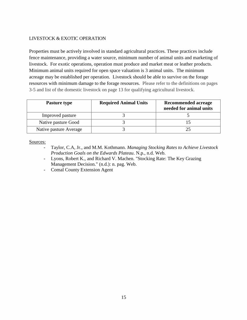
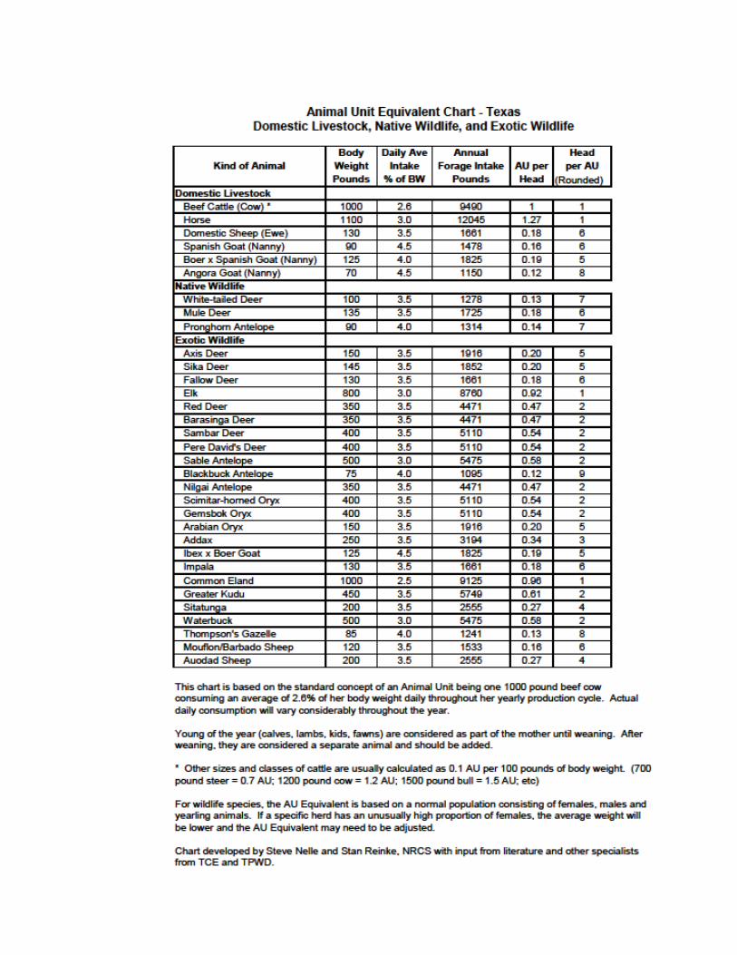
LIVESTOCK & EXOTIC OPERATION
Properties must be actively involved in standard agricultural practices. These practices include
fence maintenance, providing a water source, minimum number of animal units and marketing of
livestock. For exotic operations, operation must produce and market meat or leather products.
Minimum animal units required for open space valuation is 3 animal units. The minimum
acreage may be established per operation. Livestock should be able to survive on the forage
resources with minimum damage to the forage resources. Please refer to the definitions on pages
3-5 and list of the domestic livestock on page 13 for qualifying agricultural livestock.
Pasture type Required Animal Units Recommended acreage
needed for animal units
Improved pasture 3 5
Native pasture Good 3 15
Native pasture Average 3 25
Sources:
- Taylor, C.A, Jr., and M.M. Kothmann. Managing Stocking Rates to Achieve Livestock
Production Goals on the Edwards Plateau. N.p., n.d. Web.
- Lyons, Robert K., and Richard V. Machen. "Stocking Rate: The Key Grazing
Management Decision." (n.d.): n. pag. Web.
- Comal County Extension Agent
16

17
BEEKEEPING
Beekeeping is an agricultural-use and shall qualify for agricultural-use productivity
valuation if used for pollination or for the production of human food or other tangible
products having a commercial value (Sec 23.51(2) Texas Property Tax Code [TPTC]).
The intent of the law is for more people to raise bees (Dennis Herbert).
The size requirements are a minimum of 5 acres of open space with up to 20 acres. The property
needs to meet the same use requirements as for other agricultural use operations. The applicant
must provide a plan specifying the following:
- Type of bees
- Number of hives
- Map with location of hives and plant life
- List of vegetation for hive’s food source (all plant life intended to support hive)
- Marketing plan for production of human food or products that have commercial value
- Number of acres to be used for beekeeping, including leases (see LEASES on page 12 for
specifications)
- Information about bee migratory habits
- Degree of Intensity: first 5 acres 6 hives as per Section 131.001 Texas Agricultural Code’s
definition of an “Apiary”).
Number of Acres Number of Hives
5 to 6.49 6
6.5 to 7.99 7
8 to 9.49 8
9.5 to 10.99 9
11 to 12.49 10
12.5 to 13.99 11
14 to 15.49 12
15.5 to 16.99 13
17 to 18.49 14
18.5 to 19.99 15
20 16
The hives must be located on the property at least seven (7) months of the calendar year.
Hives must be active, kept alive and actively maintained. Flowering plants must be
planted to support hives IF the hives are in an area where there is limited vegetation that
requires pollination.
TPTC Section 23.51(2): ““Agricultural use’’ … [the] term also includes the use of land
to raise or keep bees for pollination or for the production of human food or other tangible
products having a commercial value, provided that the land used is not less than 5 or

18
more than 20 acres.”
Food or products must have commercial value, not commercial production. While
human food and products must be produced, the law does not require that they be sold
commercially. Legitimate beekeepers will have their bees in locations that provide food
for their bees, pollinate various agricultural crops, food crops, and manage their bees in a
manner to keep them healthy, surviving and producing for the long term.
HAY PRODUCTION
Land must be involved in standard hay production practices: tillage, fertilizing, cutting, bailing,
hauling, brush control, feeding or marketing. In typical years, 2 to 3 cuttings can be achieved.
CROP LAND OPERATION
Land must be involved in standard production practices which include: tillage, planting, fertilizing,
insect control, cutting, bailing, and marketing. In typical years, 1 cut can be achieved.
Crop Bushels
per acre yielded
Total bushels
produced
Oats 33.3 6,000
Wheat 17 6,800
Sources:
- USDA Comal county production estimates as of 2011 and 2012.
ORCHARD & VINEYARD
These operations are in the business of cultivating trees or grapevines that produce nuts or fruits which
are sold commercially. Typically, these operations have a regular schedule of pruning, spraying, and
cultivation as well as keeping the area around the trees or vines mowed or disked. Drip irrigation and
high fencing is typical for vineyards. Evidence of these practices should be evident during an onsite
inspection. Recommended minimum acreage for a vineyard operation is 3 acres.
Operation Minimum Acreage Count per Acre
Pecan 5 15 trees
Vineyard-Grape 3 100 vines

19
ECOLOGICAL LABORATORY
The Eco Laboratory is a onetime application. In other words, once the property is granted the
special valuation, the property owner need not reapply annually. A new application will be
required if the ownership of the property changes, there is a change in the use of the property,
change in the research activities or the District requests a reapplication.
Standards
The property must have a minimum of 3 studies by 3 different researchers from a private or public
university. There must be research studies actively conducted on the property as of January 1.
The property must be used for research throughout the year for a minimum of 6 months + 1 day.
The District requires a map identifying locations on the property where studies are occurring.
The applicant must submit the supplemental Ecological Laboratory form describing the research
activities. All land agreements between the property owner and any university must be signed and
dated.
WILDLIFE MANAGEMENT
To qualify under wildlife management, the land must be qualified for and appraised as open space in
the previous year. Per Rule 9.2005, Comal County is located within the Edwards Plateau (Eastern)
Region. The Board of Directors adopted in 2002 the wildlife use requirements as follows:
95% of tract must be devoted to wildlife management
92% of an association tract must be devoted to wildlife management
The minimum number of acres using the adopted ratio results in 20 acres per tract and 12.5 acres per
association tract.
Additional information is also required when a landowner is attempting to qualify their land under
wildlife management use. In addition to the 1-d-1 agricultural use application, a state wildlife
management plan must be submitted. Further information concerning the rules and requirements of
agricultural use through wildlife management may be found on the Texas Comptroller of Public
Accounts website (www.window.state.tx.us/taxinfo/proptax/agrland/) and the Texas Parks and
Wildlife Department website (ww.tpwd.state.ts.us/landwater/land/private/agricultutal_land/). Please
see separate publication for minimum intensity standards for wildlife management operations by
contacting the District or visiting our website at www.comalad.org. Once a property is approved
under wildlife management, property owner or association must submit an annual report.
20
VI. LAND TYPES
Each district is charged with creating a schedule of land types and values for their county. This is
done by gathering leases and sales from land owners. Land types are determined by the condition of
the land, the type of soil and the type of vegetation coverage on the land. Comal County has several
different land types.
The following is a list of the various land types found within the county:
Native Pasture
Improved Pasture
Dry Crop Land
Wildlife
These land types are then broken down further into two quality types: Good or Average.
DESCRIPTION OF CLASSES
Dry Crop Land: Land that is planted in row or broadcast crops with the purpose of being sold
commercially. The soil is deep and rich with little to no rocks. Less than 10% invasive brush
(cedar, mesquite, huisache, and cactus). Typical canopy is 15% or less. Fields have very little if
no trees. Slope of property is level to gently sloping (1 to 5 feet every 100 feet). Common
practices include cultivating soil as well as weed and brush control.
Improved Pasture: Fields are typically cleared but may include groups of trees. Majority is open
pasture with few rocks. Land primarily consisting of improved grass (Bermuda, Klein, Rye) with
some native grasses mixed in. Soil is deep & rich (over 6 inches in depth) with limited invasive
brush and tree growth (cedar, huisache, mesquite, cactus), with less than 25% canopy coverage.
Typical practices include fertilization of grass and shredding.
Native Pasture Good: Land primarily consisting of native grasses (little Bluestem, Sideoats
Grama, Indian Grass) with some improved grasses mixed in. Less than half of the property is
covered with invasive brush and tree growth (cedar, huisache, mesquite, cactus). Some rocks are
present and soil depth is generally greater than 3.5 inches. Slope of the land should be level to
moderate.
Native Pasture Average: Land primarily consisting of native grasses with some improved grasses
mixed in. Greater than half of the property is covered with invasive brush. Soil is generally less
than 3.5 inches. The property typically has heavy rock coverage. Slope can vary from level to
steep.
21
Wildlife Management Good: Land primarily consisting of native grasses (little Bluestem,
Sideoats Grama, Indian Grass) with some improved grasses mixed in. Less than half of the
property is covered with invasive brush and tree growth (cedar, huisache, mesquite, cactus).
Some rocks are present and soil depth is generally greater than 3.5 inches. Slope of the land
should be level to moderate.
Wildlife Management Average: Land primarily consisting of native grasses with some improved
grasses mixed in. Greater than half of the property is covered with invasive brush. Soil is
generally less than 3.5 inches. The property typically has heavy rock coverage. Slope can vary
from level to steep.
LAND TYPE CODES
The following chart list all the land type codes used to describe the type of agriculture or wildlife
use.
1DCF Dry Crop Land
1IPF Improved pasture
1IPG Native Pasture Good
1IPA Native Pasture Average
1WMG Wildlife Management Good
1WMA Wildlife Management Average
PRODUCTIVITY SCHEDULES
The Comal Appraisal District is required to develop productivity schedules each year for every
classification of agricultural land in their jurisdiction. A modified income approach, using lease
information, is the method used for appraising productivity land. Leases that are used to compile
the productivity schedules are for a five year period, beginning two years prior to the year that
the schedule is being developed for.
22
VII. AGRICULTURAL ADVISORY BOARD
The Agricultural Advisory Board is appointed by the Chief Appraiser with the advice and
consent of the Comal Appraisal District Board of Directors. The Agricultural Advisory Board
members must be land owners of the district whose land qualifies for appraisal under the Texas
Property Tax Code, Chapter 23, Subchapters C, D, E, or H and have been residents of the district
for at least five years. The board meets at least once per year without compensation.
Under the Texas Property Tax Code, the board's function is to advise the Chief Appraiser on
major issues dealing with agricultural and timber appraisal; net to land, degree of intensity
standards, and other agricultural use and appraisal issues. As an advisory body, the board has no
decision-making authority or responsibility. The Agricultural Advisory Board will not become
involved in matters dealing with individual properties or in reviewing and approving applications
for agricultural appraisal.
For more information, please review our Frequently Asked Questions or contact the District
directly at [email protected] or 830-625-8597.