COLUMBIA COUNTY OREGON Z O N I N G O R D I N A N C E
226
July 1984 [Integrated through July 2002] COLUMBIA COUNTY OREGON Z O N I N G O R D I N A N C E AMENDED: Ordinance Date (description) 85-2 MARCH, 1985 (Dwellings in resource zones) 85-7 JULY, 1985 (Divisions in resource zones, map amendments) 88-6 AUGUST, 1988 (Flood Hazard Overlay zone) 88-7 SEPTEMBER, 1988 (Horse breeding, boarding, training in FA-19) 89-1 JANUARY, 1989 (Motels in C-4) 90-1 MARCH, 1990 (repeals 89-1) 90-2 FEBRUARY, 1990 (Lot size standards in PF-76) 90-3 FEBRUARY, 1990 (Deletes Board of Adjustment) 90-4 FEBRUARY, 1990 (Temporary Permit - storage of structures & equipment) 90-5 APRIL, 1990 (Appeal procedures) 90-24 FEBRUARY, 1991 (Conditional Use Permits) 92-4 MARCH, 1992 (Division in RR-5 where 2 or more existing dwellings) 92-7 JULY, 1992 (Home Occupations, Fire Siting Standards, housekeeping) 92-14 NOVEMBER, 1992 (Sign sections) 92-16 JANUARY, 1993 (Housekeeping amendments) 93-2 MARCH, 1993 (Delete maximum building height in RIPD - §684.4)
Transcript of COLUMBIA COUNTY OREGON Z O N I N G O R D I N A N C E

July 1984[Integrated through July 2002]
COLUMBIA COUNTYOREGON
Z O N I N GO R D I N A N C E
AMENDED:Ordinance Date (description)85-2 MARCH, 1985 (Dwellings in resource zones)85-7 JULY, 1985 (Divisions in resource zones, map amendments)88-6 AUGUST, 1988 (Flood Hazard Overlay zone)88-7 SEPTEMBER, 1988 (Horse breeding, boarding, training in FA-19)89-1 JANUARY, 1989 (Motels in C-4)90-1 MARCH, 1990 (repeals 89-1)90-2 FEBRUARY, 1990 (Lot size standards in PF-76)90-3 FEBRUARY, 1990 (Deletes Board of Adjustment)90-4 FEBRUARY, 1990 (Temporary Permit - storage of structures & equipment)90-5 APRIL, 1990 (Appeal procedures)90-24 FEBRUARY, 1991 (Conditional Use Permits)92-4 MARCH, 1992 (Division in RR-5 where 2 or more existing dwellings)92-7 JULY, 1992 (Home Occupations, Fire Siting Standards, housekeeping)92-14 NOVEMBER, 1992 (Sign sections)92-16 JANUARY, 1993 (Housekeeping amendments)93-2 MARCH, 1993 (Delete maximum building height in RIPD - §684.4)

93-3 APRIL, 1993 (Frontage in RR-5 - §604.5)93-5 APRIL, 1993 (Water Dependent Construction Activities in C-2)93-8 JULY, 1993 (Airport Industrial AI zone)94-6 JANUARY, 1995 (Special Hearings, Hearings Officer)94-12 JANUARY, 1995 (Utilities and RIPD changes)95-9 NOVEMBER, 1995 (Home Occupations)97-3 APRIL, 1997 (Replats, Right-of-Way dedications)97-4 JULY, 1997 (Site Design Review amendments, Appeals to LUBA)98-1 JUNE, 1998 (Surface Mining amendments)98-2 MAY, 1998 (Lot or Parcel of Record)98-4 NOVEMBER, 1998 (RR-2, RR-5, Rural Communities) [effective 2-00]98-9 NOVEMBER, 1998 (Site Design Review - full re-write)99-2 OCTOBER, 1999 (Churches in RR-2, RR-5, RC, EC, R-10, R-7)99-4 DECEMBER, 1999 (Type 1,2 Home Occupations) [effective 3-00]99-5 NOVEMBER, 1999 (RR-2, RR-5, Rural Communities) [effective 2-00]00-04 NOVEMBER, 2000 (Goal 5 Exception, SIA) [effective 11/13/00]02-02 JUNE, 2002 (Section 1300, Sign Regulations) [effective 6/12/02]
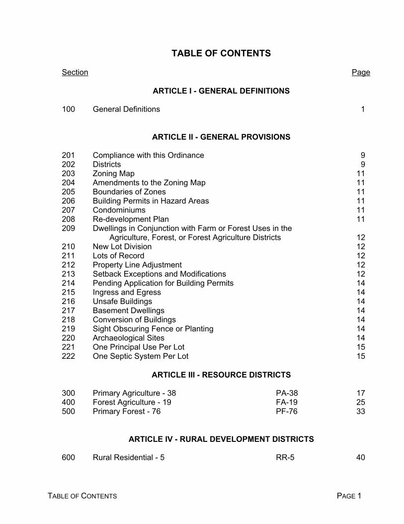
TABLE OF CONTENTS PAGE 1
TABLE OF CONTENTS
Section Page
ARTICLE I - GENERAL DEFINITIONS
100 General Definitions 1
ARTICLE II - GENERAL PROVISIONS
201 Compliance with this Ordinance 9202 Districts 9203 Zoning Map 11204 Amendments to the Zoning Map 11205 Boundaries of Zones 11206 Building Permits in Hazard Areas 11207 Condominiums 11208 Re-development Plan 11209 Dwellings in Conjunction with Farm or Forest Uses in the
Agriculture, Forest, or Forest Agriculture Districts 12210 New Lot Division 12211 Lots of Record 12212 Property Line Adjustment 12213 Setback Exceptions and Modifications 12214 Pending Application for Building Permits 14215 Ingress and Egress 14216 Unsafe Buildings 14217 Basement Dwellings 14218 Conversion of Buildings 14219 Sight Obscuring Fence or Planting 14220 Archaeological Sites 14221 One Principal Use Per Lot 15222 One Septic System Per Lot 15
ARTICLE III - RESOURCE DISTRICTS
300 Primary Agriculture - 38 PA-38 17400 Forest Agriculture - 19 FA-19 25500 Primary Forest - 76 PF-76 33
ARTICLE IV - RURAL DEVELOPMENT DISTRICTS
600 Rural Residential - 5 RR-5 40

TABLE OF CONTENTS PAGE 2
620 Rural Residential - 2 RR-2 44650 Rural Community RC 48670 Existing Commercial EC 52680 Resource Industrial - Planned Development RIPD 60
ARTICLE V - SUBURBAN DISTRICTS
700 Single-Family Residential R-10 59710 Single-Family and Two-Family Residential R-7 62720 Multiple-Family Residential MFR 65730 Mobile Home Residential MHR 69800 Highway Commercial C-5 72810 Neighborhood Commercial C-4 75820 General Commercial C-3 78830 Marine Commercial C-2 80910 ndustrial Park M-3 82920 Light Industrial M-2 85930 Heavy Industrial M-1 88940 Airport Industrial AI 92
ARTICLE VI - SPECIAL DISTRICTS, OVERLAY DISTRICTS AND SPECIAL PROVISIONS
1000 Community Service - Institutional CS-I 971010 Community Service - Utility CS-U 1001020 Community Service - Recreation CS-R 1031030 Amendments to Permit Surface Mining APSM 1061040 Surface Mining SM 1161100 Flood Hazard Overlay FH 1211120 Sensitive Bird Habitat Overlay SBH 1311130 Historic Overlay HO 1331140 Greenway Overlay GW 1341150 Aircraft Landing Field Overlay ALF 1391170 Water Quality, Streambank Stabilization,
and Fish and Wildlife Habitat WQ 1441175 Buffer Woodlot Overlay BW 1461180 Wetland Area Overlay WA 1501185 Natural Area Overlay NA 1511190 Big Game Range Overlay BGR 1521200 Planned Development Overlay PD 1541300 Signs SIGNS 1641400 Off-Street Parking and Loading OP 172
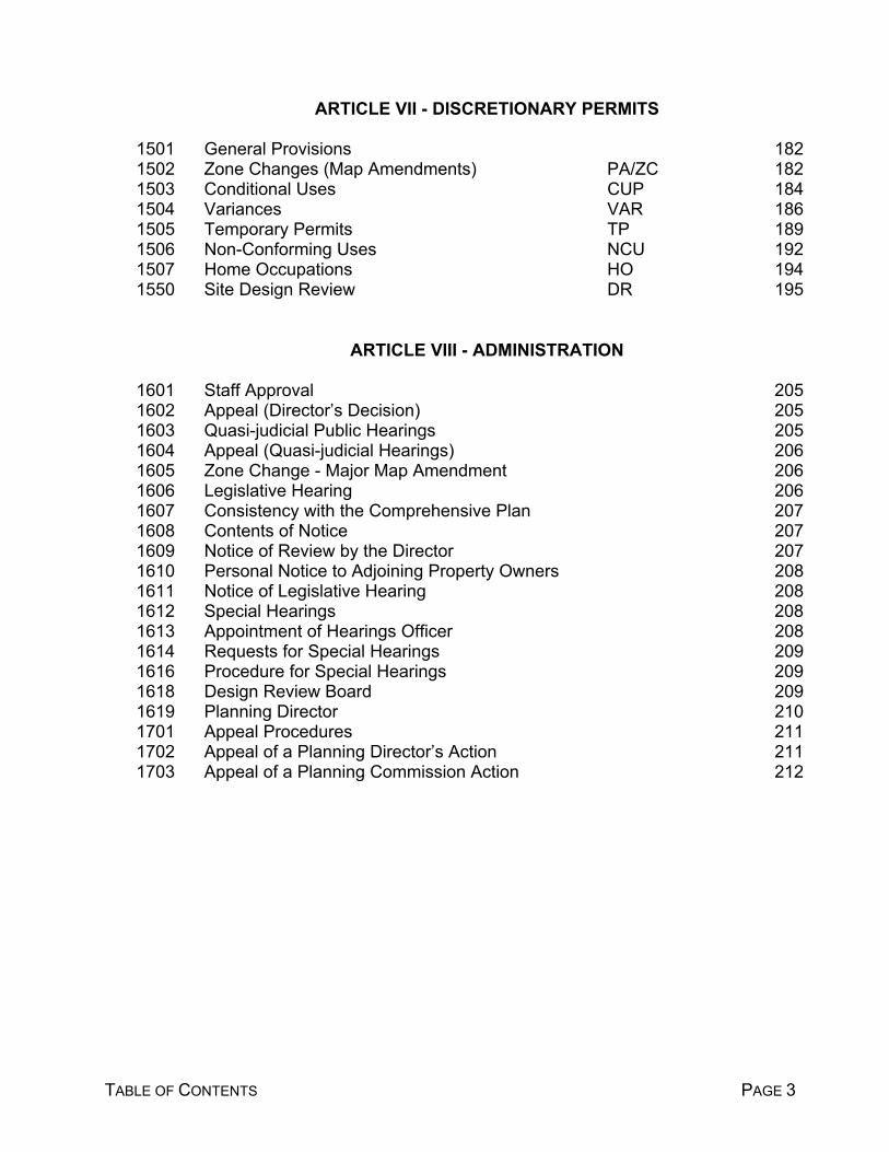
TABLE OF CONTENTS PAGE 3
ARTICLE VII - DISCRETIONARY PERMITS
1501 General Provisions 1821502 Zone Changes (Map Amendments) PA/ZC 1821503 Conditional Uses CUP 1841504 Variances VAR 1861505 Temporary Permits TP 1891506 Non-Conforming Uses NCU 1921507 Home Occupations HO 1941550 Site Design Review DR 195
ARTICLE VIII - ADMINISTRATION
1601 Staff Approval 2051602 Appeal (Director’s Decision) 2051603 Quasi-judicial Public Hearings 2051604 Appeal (Quasi-judicial Hearings) 2061605 Zone Change - Major Map Amendment 2061606 Legislative Hearing 2061607 Consistency with the Comprehensive Plan 2071608 Contents of Notice 2071609 Notice of Review by the Director 2071610 Personal Notice to Adjoining Property Owners 2081611 Notice of Legislative Hearing 2081612 Special Hearings 2081613 Appointment of Hearings Officer 2081614 Requests for Special Hearings 2091616 Procedure for Special Hearings 2091618 Design Review Board 2091619 Planning Director 2101701 Appeal Procedures 2111702 Appeal of a Planning Director’s Action 2111703 Appeal of a Planning Commission Action 212

ARTICLE I
GENERAL DEFINITIONS
-1-
ARTICLE I
Section 100 GENERAL DEFINITIONS: [Amended by Ordinance 99-4, eff. 3/07/00].
For the purpose of this ordinance, the following terms are hereby defined:
.1 Access: The way or means by which pedestrians and vehicles enter and leavethe property.
.2 Accessory Structure or Use: A structure or use incidental and subordinate tothe main use of the property and is located on the same lot or parcel with themain use and contributes to the comfort or convenience of persons occupyingthe property, but not including the keeping of livestock other than ordinaryhousehold pets.
.3 Alley: A minor way which is used primarily for vehicular access to the back orside of properties otherwise abutting on a street.
.4 Alteration: An "Alteration" may be a change in construction or a change inoccupancy. Where the term "alteration" is applied to a change of construction,it is intended to apply to any change, addition or modification in construction.When the term is used in connection with a change in occupancy, it is intendedto apply to changes of occupancy from one trade or use to another, or from onedivision of trade or use to another.
.5 Alteration, Structural: Any change or repair which would tend to prolong the lifeof the supporting members of a building or structure, such as alteration ofbearing walls, foundation, columns, beams, or girders. In addition, any changein the external dimensions of the building shall be considered a structuralalteration.
.6 Apartment: Any building or portion thereof which is designed, built, rented orleased, and occupied as a residence for 3 or more families living independentlyof each other and doing their own cooking in the same building.
.7 Basement: A portion of the building which has more than ½ of its heightmeasured from finished floor to finished ceiling above the average grade of theadjoining ground and not deemed a story, unless the ceiling is 6 feet or moreabove the average grade.
.8 Board: Board of County Commissioners for Columbia County, Oregon.
.9 Boarding House: A room or rooms hired for residence in another's house, atwhich meals are furnished.

-2-
9A. Buffer: A pattern of land uses that results in sufficient separation betweenresidential lands and rural resources such that resource uses remainpracticable.
.10 Building: Any structure used or intended for supporting or sheltering any useor occupancy.
.11 Building Height: The vertical distance above grade as defined herein to thehighest point of the coping of a flat roof or to the deck line of a mansard roof orto the average height of the highest gable of a pitched or hipped roof. Themeasurement may be taken from the highest adjoining sidewalk or groundsurface within a 5 foot horizontal distance of the exterior wall of the building,when such walkway or found surface is not more than 10 feet above grade. Theheight of a stepped or terraced building is the maximum height of any segmentof the building.
.12 Building Line: A horizontal line that coincides with the front side of the mainbuilding.
.13 Commission: The Planning Commission of Columbia County, Oregon.
.14 Common Open Space: An area within a development designed and intendedfor the use or enjoyment of all residents of the development or for the use andenjoyment of the public in general.
.15 Court: An open unoccupied space, other than a yard, on the same lot or parcelwith a building and bounded on 2 or more sides by such building.
.15A Director: The Columbia County Planning Director or the Director of theDepartment of Land Development Services, or his delegate.
.16 Dormitory: A room for sleeping purposes for more than 4 persons, which isrented.
.17 Dwelling Unit: A single unit providing complete, independent living facilities forone or more persons, including permanent provisions for living, sleeping, eating,cooking, and sanitation.
.18 Dwelling, One-Family or Single Family: A structure designed for occupancy by1 family.
.19 Dwelling, Duplex or Two-Family: A building designed exclusively for occupancyby 2 families living independently of each other.
.20 Dwelling, Apartment: A building, or portion thereof, designed for occupancy by3 or more families living independently of each other.

-3-
.21 Emergent Vegetation: Plants which may be temporarily to permanently floodedat the base but do not tolerate prolonged inundation of the entire plant.
.22 Existence: State or fact of existing: something that exists, an entity, or a being.
.23 Family: An individual or two or more persons related by blood, adoption ormarriage, or a group of not more than five persons (excluding servants) whoneed not be related by blood or marriage living together in a dwelling unit.
.24 Farm Use: The current employment of land for the primary purpose of obtaininga profit in money by raising, harvesting, and selling crops, or by the feeding,breeding, management, and sale of, or the produce of, livestock, poultry, fur-bearing animals or honeybees, or for dairying and the sale of dairy products, orany other agricultural or horticultural use or animal husbandry, or anycombination thereof and includes the preparation and storage of products raisedon such land for human use and animal use and disposal by marketing orotherwise.
.25 Fence, Sight Obscuring: A fence, consisting of wood, metal or masonry, or anevergreen hedge or other evergreen planting, arranged in such a way as toobstruct vision.
.26 Floor Area: The area included within the surrounding exterior walls of a buildingor portion thereof, exclusive of vent shafts and courts. The floor area of abuilding, or walls, shall be the usable area under the horizontal projection of theroof or floor above.
.27 Forest Uses: Are (1) the production of trees and the processing of forestproducts; (2) open space, buffers from noise, and visual separation of conflictinguses; (3) watershed protection and wildlife and fisheries habitat; (4) soilprotection from wind and water; (5) maintenance of clean air and water; (6)outdoor recreational activities and related support services and wildernessvalues compatible with these uses; and (7) grazing land for livestock.
.28 Frontage: All the property fronting on one side of a street between intersectingor intercepting streets, or between a street and a right-of-way, waterway and/ordead-end street, or county boundary, measured along the street line. Anintercepting street shall determine only the boundary of the frontage of the sideof the street which it intercepts.
.29 Garden: Tilling of soil and raising of produce or flowers in a manner that isclearly incidental to the residential use.
.30 Grade (Adjacent Ground Level): The lowest point of elevation of the finishedsurface of the ground, paving or sidewalk within the area between the buildingand the property line, or when the property line is more than 5 feet from thebuilding, between the building and a line 5 feet from the building.

-4-
.31 Grandfather: Use or condition existing prior to the adoption of this ordinance.
.32 Grazing: The use of land for pasture or horses, cattle, sheep, goats, and/orother domestic herbivorous animals, alone or in conjunction with agriculturalpursuits.
.33 Highway, State: Any road or highway designated as such by law or by theOregon Transportation Commission and includes both primary and secondarystate highways.
.34 Hedge, Sight Obscuring: A planting which is at least 80 percent opaque whenviewed horizontally from between 2 and 8 feet above the average ground level.
.35 Historical Building: Any building or structure designated under a localgovernment landmark or National Register of Historic Places, or listed in theOregon State Inventory of historical sites, buildings, and properties approved fornomination in the National Register of Historic Places by the State of OregonAdvisory Committee on Historic Preservation.
.36 Horticulture: The cultivation of plants, garden crops, trees and/or nursery stock.
.37 Hotel A building or portion thereof designed or used for occupancy ofindividuals who are lodged with or without meals.
.38 Institution, Educational: A college or university supported by public or privatefunds, tuitions, contributions, or endowments giving advanced academicinstruction as approved by a recognized accrediting agency, excludingelementary and high schools, and trade and commercial schools.
.39 Junk Yard: The use of more than 200 square feet of any lot or parcel for thedismantling or "wrecking", or for the storage or keeping, of junk including scrapmetals or other scrap materials.
.40 Kennel: Any lot or parcel or premises on which 4 or more dogs or cats of morethan 6 months of age are kept commercially for board, propagation, or sale.
.41 Loading Space: An off-street area used for the temporary parking of a vehiclewhile loading or unloading persons, merchandise, or materials.
.42 Lot: A unit of land that is created by a subdivision of land. Lots are createdfrom and are located in subdivision plats. Parcels are created from partitioningand are located in partition plats.
.43 Lot or Parcel Area: The total horizontal area enclosed within the property linesof a lot or parcel. (Lot or Parcel Size)
-5-
.44 Lot or Parcel Coverage: The area covered by primary and accessory buildings.Lot or parcel coverage shall be expressed as a percentage of the total lot orparcel area.
.45 Lot or Parcel Depth, Average: The average distance from the narrowestfrontage to the property line opposite.
.46 Lot or Parcel Line, Front: That line separating a lot or parcel from the street.For a corner lot or parcel, that line separating the side of the lot or parcel withthe lesser amount of frontage from the street. For a flag lot or parcel, that linenearest the street, excluding the pole portion of the flag.
.47 Property Line: A common boundary line between two properties.
.48 Property Line, Rear: That property line of a four-sided lot or parcel opposite thefront property line. For a triangular or more than four-sided (irregular) lot orparcel, a line within the lot or parcel not less than ten feet in length and runningparallel to, and at a maximum distance from, the front property line.
.49 Property Line, Side: Any property line not designated a front or rear propertyline.
.50 Lot Width: The horizontal distance between the side property lines, measuredat right angles to the lot or parcel depth at a point midway between the front andrear property lines.
.51 Lot Width, Average: The average horizontal distance between the side propertylines.
.52 May: As used in this ordinance, MAY is permissive and SHALL is mandatory.
.53 Mining Exploration: The search for mineral deposits by geological surveys,geophysical prospecting, bore holes and test pits and surface or undergroundheading, drifts, or tunnels.
.54 Mobile Home: A detached single-family dwelling unit with the followingcharacteristics: 1) a factory-built home designed to be transported afterfabrication on its own wheels or detachable wheels; and 2) is designed for longterm occupancy once the mobile home is installed on the site.
.55 Mobile Home Park: Land designated for the permanent location of 4 or moremobile homes. This land is commonly held in one ownership and mobile homespaces are rented to the owner of mobile homes.
.56 Modular Home: A permanent structure consisting of one or more modulesassembled in a factory in accordance with a building code, and qualified to be

-6-
financed and taxed as real property when placed upon a permanent foundation.(Sectionalized housing is a form of single family modular housing.)
.57 Motel: One or more buildings designed or used as temporary living quarters.
.58 Non-Conforming Use: A use or structure lawfully existing at the time thisordinance became effective and which does not conform with the useregulations of the district in which it is located.
.59 Ordinary High Water Line: The average height of the high water over 19 years.
.60 Owner: An owner of property or the authorized agent of an owner.
.60A. Parcel: A unit of land created by a partitioning of land. Parcel is also usedgenerically to describe a unit of land.
.61 Parking Space: A rectangle not less than 18 feet long and 9 feet wide togetherwith maneuvering and access space required for a standard Americanautomobile to park within the rectangle.
.62 Person: Every person, firm, partnership, association, or corporation.
.63 Planning Department: Person(s) who administer and enforce this ordinance.
.64 Planning Director: The Director of the Planning Department or the Director'sdelegate.
.65 Planned Development: The development of an area of land as a single entityfor a number of dwelling units or a number of uses according to a plan whichdoes not correspond in lot or parcel size, bulk, or type of regulations otherwiserequired by this ordinance.
.66 Premises: A lot or parcel with or without buildings.
.67 Principal Use: The main use to which the premises are devoted and the primarypurpose for which the premises exist.
.68 Professional Office: An office containing activities such as those offered by aphysician, surgeon, dentist, lawyer, architect, engineer, accountant, artist,teacher, real estate sales, or insurance sales.
.69 Public Water: Water which is provided off site, serves 4 or more dwellings, andmeets the State of Oregon requirements.
.70 Road, County: Every dedicated public way, thoroughfare, road, street, oreasement within the county used or intended for use by the general public forvehicular travel but excluding private driveways.
-7-
.71 Rooming House: Same as "Boarding House".
.72 School, Primary, Elementary, or High: Includes private or parochial but notnursery school, kindergarten, or day nursery, except when operated inconjunction with a school.
.72A. Setbacks: The minimum distance allowed between the property line of a lot orparcel and the building line of a permitted structure. Unless otherwise specified,the front, side, and rear yard setbacks are given for each of the zoning districtswithin the zoning ordinance.
.73 Shall: As used in this ordinance SHALL is mandatory and MAY is permissive.
.74 Sign: A publicly displayed board or placard, etc. displaying information oradvertising.
.75 Sign Area: The greatest width multiplied by the greatest height of the displayportion of a sign (one side).
.76 Sign, Public: A non-commercial sign erected by a public officer or employee inthe performance of a public duty which shall include but not be limited tomotorist information signs and warning signs.
.77 Story: That portion of a building included between the upper surface of any floorand the upper surface of the floor next above. If the finished floor level directlyabove a basement or unused under-floor space is more than 6 feet abovegrade, as defined herein, at any point, such basement or unused under-floorspace shall be considered a story.
.78 Story, Half: A story under a gable, hip, or gambrel roof of which the wall plateson at least 2 opposite exterior walls are not more than 2 feet above the floor ofsuch story.
.79 Street: A dedicated public way which provides vehicular and pedestrian accessto adjacent properties. It shall include the terms street, highway, road, avenue,boulevard, lane, place, and other such terms.
.80 Structure: That which is built or constructed, an edifice or building of any kind,or any piece of work artificially built up or composed of parts joined together insome definite manner.
.81 Timber Growing, Commercial Timber Production: The growing of trees for theproduction of timber.
.82 Tourist Court: See "Motel".

-8-
.83 Travel Trailer: A mobile shelter, usually smaller than a mobile home, used forcamping and outings rather than as a permanent dwelling which carries ahighway license but does not need a transport permit.
.84 Trailer Park: Land designed or used for the temporary parking of 4 or moretrailers or vehicles used for human habitation.
.85 Yard: An open space on a lot or parcel with a building and bounded on 1 ormore sides by such building, such space being unoccupied and unobstructedfrom 30 inches above the ground upward.
.86 Yard, Front: A yard extending across the lot or parcel, the depth of which is theminimum horizontal distance between the front property line and a line parallelthereto on the lot or parcel.
.87 Yard, Rear: A yard extending across the full width of the lot or parcel betweenthe most rear building and the rear property line; the depth of the required rearyard shall be measured horizontally from the nearest point of the rear propertyline toward the nearest part of the main building. When there is no rear propertyline, the depth of the rear yard shall be the distance from a 10 foot line parallelto the front property line, measured from one side line to the other.
.88 Yard, Side: A yard between any building and the side property line; the width
of the required side yard shall be measured horizontally from the nearest pointof the side property line toward the nearest part of the building.

ARTICLE II
GENERAL PROVISIONS

-9-
ARTICLE II
Section 200 GENERAL PROVISIONS:
201 Compliance with this Ordinance: Subject to the provisions of this Ordinance respectingexceptions, variances, and non-conforming uses or structures, land shall not be used,or buildings and structures erected, constructed, reconstructed, located, moved, orstructures altered or used or occupied contrary to this Ordinance.
202 Districts: Columbia County is hereby divided into the following districts, in each of whichthe uses, height, and area regulations are uniform:
.1 District Type Short Title Description
Resource Districts
Primary Agriculture PA-38 Agriculture district with a minimum lotor parcel size of 38 acres.
Forest Agriculture FA-19 Forest/Agriculture district with a minimum lotor parcel size of 19 acres.
Primary Forestry PF-76 Forest district with a minimum lot or parcelsize of 76 acres.
Rural Development Districts
Rural Residential - 5 RR-5 Rural Residential with a minimum lot orparcel size of 5 acres.
Rural Residential - 2 RR-2 Rural Residential with a minimum lot orparcel size of 2 acres.
Rural Community RC Residential and limited commercial andindustrial uses.
Existing Commercial EC Designation applied to all existing ruralcommercial uses
Rural Industrial - RIPD Resource related industrial uses onrural
Planned Development land

-10-
Suburban Districts
Single-Family R-10 Single Family Residential district with a Residential minimum lot or parcel size of 10,000 sq.ft.
Single-Family and R-7 Single and Two-Family Residential with a Two-Family Residential minimum lot or parcel size of 7,000 sq.ft.
Multi-Family Residential MFR Multi-Family Residential
Mobile Home Residential MH Mobile Home Residential
Marine Commercial C-2 Marine Commercial
General Commercial C-3 General Commercial
Neighborhood Commercial C-4 Neighborhood Commercial
Highway Commercial C-5 Highway Commercial
Heavy Industrial M-1 Heavy Industrial
Light Industrial M-2 Light Industrial
Industrial Park M-3 Industrial Park
Airport Industrial AI Airport Industrial
Special Districts, Overlay Districts, and Special Provisions
Community Service- CS-I Community Service / InstitutionsInstitutional
Community Service- CS-U Community Service / UtilitiesUtility
Community Service- CS-R Community Service / Recreation Recreation[Amendments to Permit Surface Mining APSM]Surface Mining SM Surface Mining
Flood Hazard Overlay FH Flood Hazard
Sensitive Bird Habitat SBH Sensitive Bird Habitat
Historic Overlay H Historic Overlay

-11-
Greenway Overlay GW Willamette River Greenway
Aircraft Landing Field ALF Aircraft Landing Field.
Water Quality, Stream- WQ Water & Riparian Areasbank, Fish & Wildlife
Buffer Woodlot BW Buffer Woodlot
Wetland Area WA Wetlands
Natural Area NA Natural Habitats
Big Game Range BGR Big Game Habitat
Planned Development PD Planned Unit Development
203 Zoning Map: The designations, locations, and boundaries of the respective districts andcertain combinations thereof described in this ordinance are established as shown byappropriate color designation, symbols, or short title identifications upon the ColumbiaCounty Zoning Map. The Zoning Map and all pertinent information shown thereon isincorporated herein and is to be deemed as much a part of this ordinance as if fully setforth; however, if a conflict appears between the Zoning Map and the written portion ofthis ordinance, the written portion shall control.
204 Amendments to the Zoning Map: The Zoning Map and each amendment thereto, asmade in accordance with the provisions of Section 1502, shall be and remain on file inthe office of the County Clerk.
205 Boundaries of Zones: Zone boundaries shall be the center line of either streets, alleys,waterways, or railroad rights-of-way, unless such boundaries are otherwise indicated onthe Zoning Map.
206 Building Permits in Hazard Areas: Applications for building permits in areas identifiedin the Comprehensive Plan as being potentially hazardous for construction shall bereviewed in accordance with Chapter 70 of the Uniform Building Code.
207 Condominiums: Condominiums are considered to be multi-family dwellings for thepurpose of this ordinance. Condominiums may be approved by the PlanningCommission following a public hearing. Condominiums shall also be subject to theprovisions of the Subdivision Ordinance which pertains to the approval of subdivisions.
208 Redevelopment Plan: The redevelopment plan is a planning tool, which is intended foruse within unincorporated urban growth boundaries. All urban residential districtsrequire a redevelopment plan be submitted when any lot or parcel created will be lessthan 5 acres. This plan is intended to help guide the land owner in his decision as to the

-12-
placement of structures and services on a lot or parcel. It is the intent of this section topresent an opportunity for the land owner to prepare for the future division of his landand to situate the structures and other improvements in a manner which will allow futuredevelopment at urban densities. Redevelopment Plans are addressed in Section 914of the Subdivision and Partitioning Ordinance.
209 Dwellings in Conjunction with Farm or Forest Uses in the Agriculture, Forest, or ForestAgriculture districts: All requests for dwellings on resource land shall be reviewed inaccordance with the provisions established for each district.
210 New Lot Division: It shall be a violation of this ordinance to partition or subdivide landinto parcels or lots smaller than the lot or parcel size required in the zoning district,except under the provisions of this ordinance allowing variances from the minimum lotor parcel size provisions.
.1 Any lot, parcel, or tract created by a deed release shall conform to all applicablezoning and subdivision requirements.
211 Lots of Record: Lots or parcels of record shall be recognized in accordance withapplicable state and/or local statutes.
.1 The use or development of any lot or parcel of record shall be subject to theregulations applied to the property when such development or use iscommenced, irrespective of the lot or parcel width, depth, or area, but subject toall other regulations.
212 Property Line Adjustment: Property lines may be adjusted between legal lots or parcelsprovided that no lot or parcel conforming to the minimum lot or parcel size requirementof the district is reduced below that minimum lot or parcel size, and any lot or parcelchanged by the property line adjustment shall satisfy or not decrease compliance withthe minimum width, depth, frontage, yard, and setback requirements of the district.
.1 Lot Line Adjustments may be allowed between undersized lots, or between anundersized lot and a complying lot, in any district provided that the resulting lotssatisfy the minimum width, depth, frontage, and yard requirements of the district,and setbacks to existing structures are not reduced by the lot line adjustmentbelow the minimum setback requirements.
213 Setback Exceptions and Modifications:
.1 Double Frontage Lots: Buildings on through lots and corner lots shall meet thefront yard setback on both streets.
.2 Front Yard Modification: The purpose of this section is to provide for flexibility inadministering the front yard setback regulations of this ordinance in specificsituations. The front yard of a lot may be modified to present a continuousappearance when adjoining lots on the same side of the street have front yards
-13-
less than required. This applies to adjoining lots with nonconforming front yardswhich existed before the district was adopted. Flag lots are excluded whenreferring to adjoining lots. The following exceptions to the front yard requirementsfor a lot are authorized in all districts.
A. If there are dwellings or structures other than accessory structures on bothadjoining lots on the same side of the street with front yards less than therequired setback, the front yard setback for the lot shall not be less thanthe average of the setbacks on the adjoining lots.
B. If there is a principal use structure on one adjoining lot on the same sideof the street with a front yard less than the required setback, the front yardfor the lot shall not be less than the average of the required setback andthe setback on the adjoining lot with the nonconforming setback.
C. Front yards on corner lots shall not be less than the average of thesetback of the front yard on the adjoining lot on the same street and therequired setback.
D. Corner vision requirements shall be as provided elsewhere in thisordinance.
E. In no case shall signs be considered as structures for the purpose of frontyard modifications. When a building setback is modified under theseprovisions, the setback for a sign provided in conjunction with the buildingmay be modified to the same extent as the modified building setback.
213.3 Additions to Existing Structures: Where a structure exists at the time when azone is adopted that would not be allowed in that zone by reasons of setbackrestrictions, additions to this structure not conforming to the front yard setbacksshall be allowed provided that:
A. The setback distance will not be decreased by the addition; (in otherwords, addition will occur on another side of building)
B. The addition conforms to all other provisions of the zoning district; and
C. The addition shall not be greater than 40 percent of the square footage onthe ground level of the existing structure.
.4 Public Dedications: Setback requirements described in this ordinance or in otherland use regulations shall not apply to existing structures when a setback isreduced by a later public dedication. Additions to such structures shall beallowed subject to subsection 213.3. That portion of a lot or parcel adjacent toan existing public roadway, which is required to be dedicated for right of way asa part of development approval, shall be considered part of the lot or parcel areafor minimum parcel size calculations.

-14-
.5 Projections into Required Yards: Architectural features and certain structuresmay project into required yards or courts under the following provisions:
A. Architectural features may project into the required yard not more than 1/3the distance of the setback requirement, and not exceeding 40 inches intoany required yard adjoining a street right-of-way.
B. Open unenclosed fire escapes may project a distance not exceeding 48inches.
C. An uncovered porch, terrace, patio, or underground structure extending nomore than 2-1/2 feet above the finished elevation may extend within 3 feetof a side lot line or within 10 feet of a front or rear lot line.
214 Pending Application for Building Permits: Nothing herein contained shall require anychange in the overall layout plans, construction size or designated use of anydevelopment, building structures or part thereof, for which official approvals and requiredbuilding permits have been granted before the enactment of this ordinance. If suchbuilding permits become void and/or a new building permit is necessary, the proposedconstruction shall conform with the zoning requirements.
215 Ingress and Egress: Every use of property shall hereafter have a defined point of usableingress and egress onto any street. Such defined points of access shall be approvedat the time of issuance of a building permit.
216 Unsafe Buildings: Nothing in this ordinance shall prevent the strengthening or restoringto a safe condition of any part of any building or structure declared unsafe by properauthority.
217 Basement Dwellings: Structures consisting of a basement only shall not be used as adwelling in any district, excluding underground or subterranean homes.
218 Conversion of Buildings: The conversion of the use or occupancy of any building, or theconversion of any dwelling so as to accommodate an increased number of dwelling unitsor families shall be permitted only within a district in which a new building of similaroccupancy would be permitted under this ordinance, and only when the resultingoccupancy will comply with the requirements governing new construction and use insuch district.
219 Sight-Obscuring Fence or Planting: The use for which a sight-obscuring fence orplanting is required shall not begin operation until the fence or planting is erected or inplace and approved by the Director, or his designate.
220 Archaeological Sites
.1 Archaeological Sites:

-15-
A. All archaeological sites known or discovered shall be inventoried for theirarcheological significance in accordance with standards set by the StateArchaeologist. If a conflicting use is proposed for an area containing anarchaeological site(s), the Planning Commission shall hold a publichearing, in accordance with Section 1603, to review testimony regardingthe site(s) and establish measures to mitigate potential conflicts asnecessary. The State Archaeologist shall be notified of such publichearings.
221 One Principal Use Per Lot: Only one principal use may be placed on each legal lot orparcel.
222 One Septic System Per Lot: Only one residential subsurface sewage disposal systemmay be installed on each legal lot or parcel.

-16-

ARTICLE III
RESOURCE DISTRICTS

PA - 38
-17-
Section 300 PRIMARY AGRICULTURE - 38 PA-38
301 Purpose: This district is intended to preserve, enhance, and stabilize those primeagricultural lands and farm use areas within the County which are being used, and offerthe greatest potential, for food and fiber production.
Agricultural land is comprised of predominantly Class I-IV soils as identified in the SoilCapability Classification System of the Soil Conservation Service, and other lands whichare suitable for farm use taking into consideration soil fertility, suitability for grazing,climatic conditions, existing and future availability of water for farm irrigation purposes,existing land use patterns, and accepted farming practices. Agricultural land shall alsoinclude other classes which are necessary to permit farm practices to be undertaken onadjacent or nearby lands.
302 Permitted Uses:
.1 Farm use as defined by Subsection 2 of ORS 215.203.
.2 The propagation or harvesting of a forest product.
.3 Dwellings customarily provided in conjunction with farm use on contiguousownerships of 38 or more acres, including a mobile home for the owner, operator,or employees, required to carry out a use permitted outright.
.4 A dwelling on real property used for farm use if the dwelling is:
A) Located on the same lot or parcel as the dwelling of the farm operator; and
B) Occupied by a relative, which means, grandparent, grandchild, parent,child, brother or sister of the farm operator or the farm operator's spouse,whose assistance in the management of the farm use is or will be requiredby the farm operator.
.5 Farm buildings, other than dwellings, customarily provided in conjunction withfarm use, including roadside stands selling farm products produced on propertyowned or leased for farm use by the owner of the property on which the roadsidestand is located.
.6 Operations for the exploration for and production of geothermal resources asdefined by ORS 522.005.
302.7 A site for the disposal of solid waste that has been ordered to be established bythe Environmental Quality Commission under ORS 459.049, together withequipment, facilities, or buildings necessary for its operation.

PA - 38
-18-
.8 Signs subject to Section 1300.
.9 Mobile home or recreation vehicle used during the construction of a permitted usefor which a building or siting permit has been issued subject to Section 1505.
303 Conditional Uses:
.1 Commercial activities that are in conjunction with farm use.
.2 Operations conducted for the mining and processing of geothermal resources asdefined by ORS 522.005, or exploration, mining, and processing of aggregateand other mineral resources or other subsurface resources.
.3 Public or private schools.
.4 Churches.
.5 Community centers owned and operated by a governmental agency or anonprofit community organization.
.6 Golf course.
.7 Parks, playgrounds, hunting and fishing preserves, and campgrounds.
.8 Facilities necessary for public utility service.
.9 Personal use airports for airplanes and helicopter pads, including associatedhangar, maintenance and service facilities as provided by ORS 215.213(2)(g).
.10 Home occupations carried on by the resident as an accessory use withindwellings or other buildings allowed in conjunction with farm use.
303.11 A facility for the primary processing for forest products, provided that such facilityis found to not seriously interfere with accepted farming practices and iscompatible with farm uses described in Subsection 2 of ORS 215.203. Such afacility may be approved for a one-year period which is renewable. Thesefacilities are intended to be only portable or temporary in nature. The primaryprocessing of a forest product, as used in this section, means the use of aportable chipper or stud mill or other similar method of initial treatment of a forestproduct in order to enable its shipment to market. Forest products, as used inthis section, means timber grown upon a parcel of land or contiguous land wherethe primary processing facility is located.
.12 The boarding of horses for profit.

PA - 38
-19-
.13 Single family dwellings or mobile homes and their accessory uses, not providedin conjunction with farm use, may be granted conditional approval upon a findingthat each such proposed use:
A. Is compatible with farm uses and is consistent with the intent and purposeset forth in this ordinance relating to farm lands; and
B. Does not interfere seriously with accepted farming practices on adjacentlands devoted to farm use; and
C. Does not materially alter the stability of the overall land use pattern of thearea; and
D. Is situated upon generally unsuitable land for the production of farm cropsand livestock, considering the terrain, adverse soil or land conditions,drainage and flooding, vegetation, location and size of the tract.
E. Any application for a non-farm dwelling in an exclusive farm use zone shallbe approved only if the parcel on which the dwelling is to be built has beenremoved from the farm tax deferral in accordance with the provisions ofORS 215.236.
.14 Construction or placement of a dwelling or manufactured dwelling customarilyprovided in conjunction with farm use on a contiguous ownership smaller than 38acres upon a finding that all of the following criteria are satisfied:
A. The parcel will support accepted farm practices as defined by ORS215.203 by showing that (1) the parcel will be used in conjunction withother farmland in the area to contribute to a continuation of the existingcommercial agricultural enterprise; or (2) the ownership will be used for analternative commercial farm use of greater intensity (such as a nursery)than commercial farms in the area, and that such a use will be consistentwith the continuation of existing commercial agriculture in the area; and
B. The dwelling is located in such a way that it does not reduce the existingor potential agricultural productivity of the parcel; and
C. The addition and location of new structures and improvements includingdwellings, fences, roads, utilities, wells, etc. will not impose limitations onexisting commercial farm practices in the area; and
D. The construction or placement of the dwelling is in conformity with theState Legislature's Agricultural Land Use Policy as set forth in ORS215.243, which declares that: "The preservation of a maximum amount
PA - 38
-20-
of the limited supply of agricultural land...in large blocks is necessary inmaintaining the agricultural economy of the state..."
E. The dwelling is to be used in conjunction with an existing commercial farmuse on the parcel.
303.15 Temporary placement of a mobile home or recreation vehicle to be used becauseof a health hardship subject to Section 1505.
304 Standards:
.1 The minimum lot or parcel size for all farm and forest activities shall be 38 acres,except as provided in Section 305 below. The minimum lot or parcel size for allother permitted and conditional uses shall be 20,000 square feet. [Note: Statelaw now requires 80 acres minimum parcel size]
.2 The minimum average lot or parcel width shall be 100 feet for all activities exceptfarming or forestry.
.3 The minimum average lot or parcel depth shall be 100 feet for all activities exceptfarming or forestry.
.4 All parcels and lots permitted by Section 302 shall have a minimum of 50 footfrontage on a public or private right-of-way.
.5 All parcels and lots permitted by Section 303 shall have a minimum of 50 footfrontage on a public right-of-way. This is also the minimum width of any lot orparcel.
.6 No structure shall be constructed closer than 30 feet to a property line.
.7 Unless otherwise prohibited, the maximum building height for all non-farm, non-forest structures shall be 50 feet or 2-1/2 stories, whichever is less. Unlessotherwise prohibited, structures such as barns, silos, windmills, antennas,chimneys, or similar structures may exceed the height limitations to a maximumheight of 50 feet.
305 Partitions:
.1 Any proposed partition of land that would result in the creation of a farm or forestparcel smaller than 38 acres shall be reviewed in accordance with therequirements of ORS 215.263, Section 305.2 below, and the County Subdivisionand Partitioning Ordinance. If all parcels proposed to be created exceed 38acres, the partition shall be reviewed in accordance with the requirements of theCounty Subdivision and Partitioning Ordinance.

PA - 38
-21-
.2 The proponent of a partition request for the creation of a parcel or parcels smallerthan the prescribed minimum must demonstrate that the parcel is for a non-farmuse reviewed and approved under Section 303.13, or that all of the followingcriteria are satisfied:
A. Any newly created parcels will support farm practices as defined by ORS215.203 by showing (1) that the parcel will be used in conjunction withother farmland in the area to contribute to a continuation of the existingcommercial agricultural enterprise; or (2) the parcel will be used for analternative commercial farm use of greater intensity (such as a nursery)and that such a use will be consistent with the continuation of existingcommercial agriculture in the area; and the proposed parcels are largeenough to enable the proposed agricultural use to be practiced as it is onsimilar commercial enterprises in the region; and
B. The parcelization will not reduce the existing or potential agriculturalproductivity of the subject property; and
C. The addition and location of new structures and improvements, includinghouses, fences, roads, utilities, wells, etc., will not impose limitations onexisting farm practices in the area; and
D. The parcelization is in conformity with the State Legislature's AgriculturalLand Use Policy as set forth in ORS 215.243, which declares that "Thepreservation of a maximum amount of the limited supply of agriculturalland...in large blocks is necessary in maintaining the agricultural economyof the State..."
306 Special Notification Requirements:
.1 The County Agricultural Extension office and the Soil and Water ConservationService shall be notified of all requests made under Section 303 and 305 of thischapter. These two agencies will be given 10 working days to comment on suchrequests.
307 Homestead Lot or parcel: The purpose of this section is to encourage the retention ofagricultural land in large blocks, while providing the opportunity for residents who are nolonger able, or who no longer desire, to farm the land to retain their homes and sell thebalance of the property. The Planning Director may approve a lot or parcel division fora principal dwelling existing on the effective date of this ordinance, and this lot or parcelshall be permitted as a non-farm use, provided that all of the following criteria aresatisfied:
.1 The property is 38 acres or larger prior to the creation of the homestead lot.

PA - 38
-22-
.2 The lot or parcel created to accommodate the dwelling shall include no more than2 acres of land, unless soil conditions, topography, or other unique circumstancesrequire a greater land area, and such lot or parcel shall not be divided further.
.3 The remainder of the property shall not be partitioned further under this provision.
.4 A lot or parcel created under this provision shall be partitioned in accordance withthe requirements of the County Subdivision and Partitioning Ordinance.
.5 Documents recorded to carry out a partition approved under this provision shallinclude a statement that such lots or parcel are for "Homestead Purposes" andare subject to the restrictions imposed herein.
.6 The existing dwelling:
A. Is compatible with farm uses and is consistent with the intent and purposeset forth in this ordinance relating to farm lands; and
B. Does not interfere seriously with accepted farming practices on adjacentlands devoted to farm use; and
C. Does not materially alter the stability of the overall land use pattern of thearea; and
D. Is situated upon generally unsuitable land for the production of farm cropsand livestock, considering the terrain, adverse soil or land conditions,drainage and flooding, vegetation, location and size of the tract.
309 Land Divisions:
A farm or forest parcel smaller than 38 acres may be created in the PA-38 zone only ifthe application, investigation, evidence, findings and conclusions show that all of thefollowing conditions exist:
.1 The proposed parcel is intended for farm use, and is appropriate to thecontinuation of the existing commercial agricultural economy in the area;
.2 The proposed parcel will not have a significant adverse impact on identifiedsensitive fish and wildlife habitats;
.3 The proposed parcel will be capable of contributing in substantial way to theexisting agricultural processors and established farm markets; and
.4 Such findings shall be based on at least the following factors:

PA - 38
-23-
A. The proposed division is compatible with the farm use in the area anddoes not interfere, either in itself or in the location of improvements, with'current accepted farming practices', as that term is defined in ORS215.203, which characterizes such use;
B. The proposed division is consistent with the agricultural land use policy forthe State of Oregon expressed in ORS 215.243;
C. The proposed division does not materially alter the stability of the overallland use pattern of the area, nor substantially add to the demand forincreased use of roads, ground water during growing seasons, or publicfacilities and services.
.5 The proposed division shall create parcels typical of the surrounding agriculturalarea and be of sufficient size to support production of food or fiber using acceptedfarm practices as that term is defined in ORS 215.203 after findings have beenmade with respect to the following:
A. Soil types and patterns in the area and typical yields;
B. Type of crops grown in the area and typical yields;
C. Potential markets;
D. Other relevant information included in the agricultural element of theColumbia County Comprehensive Plan; and
E. Average size of parcels on which commercial agricultural farming ispracticed in the area.
In no case shall parcels less than 38 acres be allowed except as providedelsewhere in this zoning ordinance.
310 Fire Siting Standards for Dwellings and Roads: The following fire siting standards ortheir equivalent shall apply to all new dwellings in this zone:
.1 If a water supply is available and suitable for fire protection, such as a swimmingpool, pond, stream or lake, then road access to within 15 feet of the water's edgeshall be provided for pumping units. The road access shall accommodate theturnaround of fire fighting equipment. Permanent signs shall be posted along theaccess route to indicate the location of the emergency water source.
.2 The owner of the dwelling shall maintain a primary fuel-free break area aroundall structures, shall clear and maintain a secondary fuel-free break area, and shallmaintain adequate access to the dwelling for fire fighting vehicles in

PA - 38
-24-
accordance with the provisions in "Protecting Your Home From Wildfire"published by the National Fire Protection Association.
.3 All roads in this zone, except private roads and bridges for commercial forestuses, shall be constructed so as to provide adequate access for fire fightingequipment, according to the standards provided by the local rural fire protectiondistrict or State Department of Forestry.

FA - 19
-25-
Section 400 FOREST AGRICULTURE - 19 FA-19
401 Purpose: The purpose of this zone is to protect and promote farm and forest uses onlands which have resource value, but which are not suited for either the Farm (PA-38)zone or the Forest (PF-76) zone because of smaller parcel size, conflicting adjacentuses, adverse physical features, or other limiting factors.
402 Permitted Uses:
.1 Farm uses as defined by Subsection (2) of ORS 215.203.
.2 The propagation or harvesting of a forest product.
.3 Dwellings necessary and accessory to farm or forest use on contiguousownerships of 19 or more acres, including a mobile home, for the owner,operator, or employees, required to carry out a use permitted outright.Applications for a building permit pursuant to this section shall be accompaniedby a management plan which shall be reviewed by the Planning Director underthe procedures set forth in Section 1601 of this ordinance. The application shallnot be approved unless the Planning Director determines that the requirementsof this section are met. The management plan must provide the followinginformation. Additional information may also be required.
A. A description of the parcel, including soil types, forest site classes, forestspecies, ages and densities, topography, streams, wetland areas, roads,structures, and other significant geographic features.
B. A determination of which forest use(s) the forest residence is needed for.
C. A discussion of why the forest residence is needed to conduct the forestuse(s) identified in B. above.
D. A discussion of methods and practices the landowner is or will be using toconserve forest resources, including but not limited to:
1. soil conservation and erosion control;
2. fire protection;
3. brush management;
4. fish and wildlife habitat management;
5. harvest and revegetation plans;
FA - 19
-26-
6. stream quality protection; and
7. fencing requirements and costs.
E. All forest practices must comply with the Oregon Forest Practices Act.
.4 A dwelling on real property used for farm help if the dwelling is:
A. Located on the same lot or parcel, as those terms are defined in ORS92.010, as the dwelling of the farm operator; and
B. Occupied by a relative, which means grandparent, grandchild, parent,child, brother, or sister of the farm operator or the farm operators spouse,whose assistance in the management of the farm use is or will be requiredby the farm operator.
.5 Buildings, other than dwellings, customarily provided in conjunction with farm orforest uses, including roadside stands for selling farm products produced onproperty owned or leased for farm use by the owner of the property on which theroadside stand is located.
.6 Operations conducted for the exploration of geothermal resources as defined byORS 522.005.
403 Planning Director Review: Residential structures allowed by Section 402 within majorand peripheral big game range shall be reviewed by the Planning Director to determineconsistency with the maintenance of big game habitat. In making this determination,consideration shall be given to the cumulative effects of the proposed action and otherdevelopment in the area on big game habitat. Where such a finding is made,development shall be sited to minimize the impact on big game habitat. To minimize theimpact, structures shall: be located near existing roads; be as close as possible toexisting structures on adjoining lots; and be clustered where several structures areproposed.

FA - 19
-27-
404 Conditional Uses: In an FA-19 zone, the following uses and their accessory uses arepermitted subject to the provisions of Sections 405 and 406. A conditional use shall bereviewed according to the procedures provided by Section 1503.
.1 Commercial activities that are in conjunction with a farm use or that arenecessary for and accessory to a forest use.
.2 Operations conducted for the mining and processing of geothermal resources asdefined by ORS 522.005, or exploration, mining, and processing of aggregateand other mineral resources or other subsurface resources.
.3 Public or private schools.
.4 Churches.
.5 Community centers owned and operated by a governmental agency or anonprofit community organization.
.6 Parks, playgrounds, hunting and fishing preserves, and campgrounds andaccessory facilities.
.7 Facilities necessary for public utility service.
.8 Airplane landing strips and helipads and accessory facilities in conjunction withfarm or forest use.
.9 Home occupations carried on by the resident as an accessory use withindwellings or other buildings allowed in conjunction with farm or forest use.
.10 A facility for the primary processing of forest products, provided that such facilityis found to not seriously interfere with accepted farming practices and iscompatible with farm uses described in Subsection 2 of ORS 215.203. Such afacility may be approved for a one-year period which is renewable. Thesefacilities are intended to be only portable or temporary in nature. The primaryprocessing of a forest product, as used in this section, means the use of aportable chipper or stud mill or other similar methods of initial treatment of aforest product in order to enable its shipment to market. Forest products, as usedin this section, means timber grown upon a parcel of land or contiguous landwhere the primary processing facility is located.
404.11 The breeding, boarding and training of horses for profit provided the Commissionor the Board finds in the particular case that the request can be granted pursuantto a proper exception to Goal 4 - Forest Lands.

FA - 19
-28-
.12 A site for the disposal of solid waste approved by the governing body of a city orcounty or both and for which a permit has been granted under ORS 459.245 bythe Department of Environmental Quality together with equipment, facilities, orbuildings necessary for its operation.
.13 One-family dwellings, mobile homes, or recreation vehicles and their accessoryuses not provided in conjunction with farm or forest use may be grantedconditional approval upon a finding that each such proposed use:
A. Is compatible with farm or forest uses and is consistent with the intent andpurpose set forth in this ordinance relating to farm or forest lands; and
B. Does not interfere seriously with accepted farming or forest practices onadjacent lands devoted to farm or forest use; and
C. Does not materially alter the stability of the overall land use pattern of thearea; and
D. Is situated upon generally unsuitable land for the production of farm orforest crops and livestock, considering the terrain, adverse soil or landconditions, drainage and flooding, vegetation, location and size of thetract.
.14 Construction or placement of a dwelling or mobile home necessary for andaccessory to farm use on a contiguous ownership smaller than 19 acres upon afinding that all of the following criteria are satisfied:
A. The parcel will support accepted farm practices as defined by ORS215.203 by showing that (1) the parcel will be used in conjunction withother farmland in the area to contribute to a continuation of the existingcommercial agriculture, or (2) the ownership will be used for an alternativecommercial farm use of greater intensity (such as a nursery), and thatsuch a use will be consistent with the continuation of existing commercialagriculture or forestry in the area; and
B. The dwelling is located in such a way that it does not reduce the existingor potential productivity of the parcel; and
C. The addition and location of new structures and improvements, includingdwellings, fences, roads, utilities, wells, etc., will not impose limitations onexisting commercial farm and forest practices in the area; and
D. The construction or placement of the dwelling is in conformity with theState Legislature's Agricultural Land Use Policy as set forth in ORS215.243, which declares that: "The preservation of a maximum amount

FA - 19
-29-
of the limited supply of agricultural land...in large blocks is necessary inmaintaining the agricultural economy of the state..."; and
E. The dwellings to be used in conjunction with an existing commercial farmuse on the parcel.
F. A farm management plan may be required to assure compliance with thecriteria established by 404.14.
.15 Signs subject to Chapter 1300.
405 All Conditional Uses Permitted in the FA-19 Zone Shall Meet the FollowingRequirements:
.1 The use will not significantly increase the cost, nor interfere with accepted forestmanagement practices or farm uses on adjacent or nearby lands devoted toforest or farm use.
.2 The use will be limited to a site no larger than necessary to accommodate theactivity and, as such will not materially alter the stability of the overall land usepattern of the area or substantially limit or impair the permitted uses ofsurrounding properties. If necessary, measures will be taken to minimizepotential negative effects on adjacent forest lands.
.3 The use does not constitute an unnecessary fire hazard, and provides for firesafety measures in planning, design, construction, and operation.
.4 Public utilities are to develop or utilize rights-of-way that have the least adverseimpact on forest resources. Existing rights-of-way are to be utilized whereverpossible.
.5 Road standards shall be limited to the minimum width necessary for managementand safety.
.6 Development within major and peripheral big game range shall be consistent withthe maintenance of big game habitat. In making this determination, considerationshall be given to the cumulative effects of the proposed action and otherdevelopment in area on big game habitat. Where such a finding is made,development shall be sited to minimize the impact on big game habitat. Tominimize the impact, structures shall: be located near existing roads; be as closeas possible to existing structures on adjoining lots; and be clustered whereseveral structures are proposed.
406 All dwelling units, including mobile homes, shall meet the following additionalrequirements:

FA - 19
-30-
.1 That on forest land, provision has been made for fire safety measures inaccordance with the guide published by the Northwest Interagency FirePrevention Group entitled, "Fire Safety Considerations for Development in ForestAreas".
.2 That responsibility for protection from wildlife damage on the property beassumed by the dwelling's owner or occupant.
.3 That the use does not impose any limitation on the operation of a primary woodprocessing facility.
.4 That a farm or forest management impact statement may be required that showsthe relationship between the proposed residential use and surrounding resourceuses, including setbacks for any dwellings from forest or farm uses to assure thatthe above conditions are met.
407 Standards - In a FA-19 zone, the following standards shall apply:
.1 The minimum lot size for all permitted and conditional uses, except farm or forestuses, shall be 20,000 square feet. The minimum lot or parcel size for farm orforest uses shall be 19 acres except as provided in Section 409 below. [Note:State law now requires 80 acres minimum parcel size]
.2 The minimum lot or parcel width at the front building line for all uses except farmor forest uses shall be 100 feet.
.3 The minimum lot or parcel depth for all uses except farm or forest uses shall be100 feet.
.4 No structure shall be constructed closer than 30 feet to a property line.
.5 The maximum building height for all non-farm structures shall be 35 feet.
408 Homestead Lot: The purpose of this section is to encourage the retention of farm andforest land in large blocks, while providing the opportunity for residents who are nolonger able, or who no longer desire, to manage farm and forest lands to retain theirhomes and sell the balance of the property. The Planning Director may approve a lotor parcel division for a principal dwelling existing on the effective date of this ordinance,and this lot or parcel shall be permitted as a non-farm use, provided that all of thefollowing criteria are satisfied:
.1 The property is 19 acres or larger prior to the creation of the homestead lot.

FA - 19
-31-
.2 The lot or parcel created to accommodate the dwelling shall include no more than2 acres of land, unless soil conditions, topography, or other unique circumstancesrequire a greater land area and such lot or parcel shall not be divided further.
.3 The remainder of the property shall not be partitioned further under this provision.
.4 A lot or parcel created under this provision shall be partitioned in accordance withthe requirements of the County Subdivision and Partitioning Ordinance.
.5 Documents recorded to carry out a partition approved under this provision shallinclude a statement that such lots or parcels are for "Homestead Purposes" andare subject to the restrictions imposed herein.
.6 The dwelling meets the standards for residential structures set forth in ORS215.283(3).
409 Partitions:
.1 Any proposed division of land that results in the creation of a parcel smaller than19 acres shall be reviewed according to the procedures established by Section1504 of this ordinance. If the parcels created are not smaller than the 19 acresminimum, the proposed division shall be reviewed in accordance with the CountySubdivision and Partitioning Ordinance.
.2 The proponent of a partition request for the creation of a parcel or parcels smallerthan the prescribed minimum must demonstrate that the parcel is for non-farmnon-forest uses reviewed and approved under Subsection 404.13 or that all thefollowing criteria are satisfied:
A. Any newly created parcels will support accepted farm or forest practicesby showing (1) that the parcel will be used in conjunction with other landin the area to contribute to the continuation of the existing commercialforestry/agricultural enterprises in the area; or (2) the parcel will be usedfor an alternative commercial farm or forest use of greater intensity, andthat such use will be consistent with the continuation of existingcommercial agriculture or forestry in the area; and (3) the proposedparcels are large enough to enable the proposed agricultural or forestryuse to be practiced as it is on similar commercial enterprises in the region;and
B. The parcelization will not reduce the existing or potential forest/agriculturalproductivity of the subject property;

FA - 19
-32-
C. The addition and location of new structures and improvements, includinghouses, fences, roads, utilities, wells, etc., will not impose limitations onexisting farm practices in the area; and
D. The parcelization is in conformity with the State Legislature's AgriculturalLand Use Policy as set forth in ORS 215.243 which declares that "Thepreservation of a maximum amount of the limited supply of agriculturalland...in large blocks is necessary in maintaining the agricultural economyof the State..."
.3 Procedures for approving partition requests shall be as provided in the CountySubdivision Ordinance.
410 Reestablishment of Non-farm or Non-forest Use: A non-farm or non-forest use that isunintentionally destroyed by fire, other casualty or natural disaster may be reestablishedto its previous nature and extent as provided in ORS 215.215(1), so long as thereestablishment meets all other building, plumbing, sanitation and other codes,ordinances, and permit requirements.
411 Notification of State and Local Agencies: The Columbia County Soil and WaterConservation District shall be notified and requested to comment on all applications filedunder Sections 404 and 408 of this ordinance that affect farmland. The appropriateoffices of the Oregon Department of forestry and Fish and Wildlife shall be notified andrequested to comment on all applications filed under Sections 404 and 408 of thisordinance that affect forest lands. To be assured consideration, responses should bereceived within 10 days of the date of mailing.
412 Fire Siting Standards for Dwellings and Roads: The following fire siting standards ortheir equivalent shall apply to all new dwellings in this zone:
.1 If a water supply is available and suitable for fire protection, such as a swimmingpool, pond, stream or lake, then road access to within 15 feet of the water's edgeshall be provided for pumping units. The road access shall accommodate theturnaround of fire fighting equipment. Permanent signs shall be posted along theaccess route to indicate the location of the emergency water source.
.2 The owner of the dwelling shall maintain a primary fuel-free break area aroundall structures, shall clear and maintain a secondary fuel-free break area, and shallmaintain adequate access to the dwelling for fire fighting vehicles in accordancewith the provisions in "Protecting Your Home From Wildfire" published by theNational Fire Protection Association.
.3 All roads in this zone, except private roads and bridges for commercial forestuses, shall be constructed so as to provide adequate access for fire fighting

FA - 19
-33-
equipment, according to the standards provided by the local rural fire protectiondistrict or State Department of Forestry.

PF - 76
-34-
Section 500 PRIMARY FOREST - 76 PF-76
501 Purpose: The purpose of this zone is to retain forest land for forest use and toencourage the management of forest land for the growing, harvesting, and processingof forest crops consistent with the Oregon Forest Practices Act. And to provide for otherforest uses including watershed protection, soil protection, maintenance of clean air andwater, wildlife and fisheries habitat, outdoor recreation activities, open space and scenicpreservation, and agricultural activities free from the encroachment of conflicting non-forest uses and influences.
.1 Uses related to and in support of forest operations;
.2 Uses to conserve soil, air and water quality and to provide for fish and wildliferesources, agriculture an recreational opportunities appropriate in a forestenvironment;
.3 Locationally dependent uses, such as communication towers, mineral andaggregate resources; etc.
.4 Forest management dwellings as provided for in OAR 660-06-027; and
.5 Other dwellings under prescribed conditions.
502 Permitted Uses:
.1 Commercial forest management consistent with the intent and purposes of theOregon Forest Practices Act.
.2 Fish and wildlife management.
.3 Structures and facilities necessary for and accessory to commercial forestmanagement and fish and wildlife management. The uses served by suchstructures and facilities may include, but are not limited to: administration,equipment storage and maintenance, communications, fire protection, fishrearing, and residences for property owners, employers or full-time employeesdirectly accessory to and required for commercial forest management or fish andwildlife management. A management plan approved by the Planning Director isrequired before a building permit is issued to assure that structures and facilitiesare consistent with the requirement of this ordinance. The management planshall contain the information required by Section 402.3 of this ordinance, and itshall be reviewed under the procedures set forth in Section 1601 of thisordinance.
.4 [ORS Repealed 7-1-1985.]
PF - 76
-35-
.5 Primary wood processing facilities. Such facilities include, but are not limited to:pole and piling preparation, small portable saw mills, log sorting yards, woodchipping operations, fence post manufacturing, and fire wood production.
.6 Facilities and test sites for experimental and research activities associated withthe propagation, management, or harvesting of forest tree species.
.7 Forest tree nurseries and accessory facilities.
.8 Rock quarries, including the crushing, screening, and stockpiling of materials,when the rock is used for a commercial forest operation or when an operatingpermit and reclamation are not required by state law (ORS 517.790).Commercial forest operations include construction, reconstruction, ormaintenance of forest access roads, or supporting forest management activitiessuch as riprapping, bridge wing wall diversions, culvert bedding, and other similaractivities located on forest lands and conducted for the purpose of forestmanagement.
.9 Helipad and balloon bedding areas necessary to commercial forest management.
.10 Farm use as defined by ORS 215.203(2).
.11 Rehabilitation, replacement, repair, and minor improvement of existing parkstructures and facilities.
503 Conditional Uses: In the PF Zone the following conditional uses and their accessoryuses are permitted subject to the provisions of Section 504 and 505. A conditional useshall be reviewed according to the procedures provided in Section 1503.
.1 Wood processing facilities other than primary processing.
.2 Operations conducted for the exploration, mining, and processing of geothermal,aggregate, and other mineral or subsurface resources not permitted outright.
.3 Parks, campgrounds, hunting and fishing reserves, and other recreational usesthat require roads or structures.
.4 Small scale solid waste disposal sites or transfer stations not to exceed 20 acres.
.5 Water impoundments of not greater than 1000 acre feet.

PF - 76
-36-
.6 Utility facilities, including utility corridors for electrical transmission lines of up to115 KV's, and small electrical generation facilities.
.7 Radio or television stations, transmitters or towers, except those installationsused for the purpose of commercial forest management which are allowedoutright.
.8 Airplane landings strips and accessory facilities in conjunction with forest use.
.9 A nonresource-related single-family residential structure.
.10 Storage of construction equipment and materials, including a structure to be usedfor this purpose.
.11 Home occupation.
.12 Signs subject to Section 1300.
504 All Conditional Uses Permitted in the PF-76 Zone Shall Meet the FollowingRequirements:
.1 The use is consistent with forest and farm uses and with the intent and purposesset forth in the Oregon Forest Practices Act.
.2 The use will not significantly increase the cost, nor interfere with accepted forestmanagement practices or farm uses on adjacent or nearby lands devoted toforest or farm use.
.3 The use will be limited to a site no larger than necessary to accommodate theactivity, and as such will not materially alter the stability of the overall land usepattern of the area or substantially limit or impair the permitted uses ofsurrounding properties. If necessary, measures will be taken to minimizepotential negative effects on adjacent forest lands.
.4 The use does not constitute an unnecessary fire hazard, and provides for firesafety measures in planning, design, construction, and operation.
504.5 Public utilities are to develop or utilize rights-of-way that have the least adverseimpact on forest resources. Existing rights-of-way are to be utilized whereverpossible.
.6 Development within major and peripheral big game ranges shall be sited tominimize the impact on big game habitat.

PF - 76
-37-
To minimize the impact, structures shall: be located near existing roads; be asclose as possible to existing structures on adjoining lots; and be clustered whereseveral structures are proposed.
505 Residential Structures Shall meet the following Additional Requirements:
.1 Nonresource-related structures provided by Section 503.9 shall be placed onlyon land that is generally unsuitable for commercial forestry or agriculture takinginto consideration the terrain, adverse soil or land conditions, drainage andflooding, vegetation, location and size of the tract.
.2 Provision has been made for fire safety measures in accordance with the guidepublished by the Northwest Inter-Agency Fire Prevention Group entitled, "FireSafety Considerations for Development in Forest Areas".
.3 Responsibility for protection from wildlife damage on the property shall beassumed by the dwelling's owner or occupant.
.4 The use does not impose any limitation on the operation of a primary wood-processing facility.
.5 A forest management impact statement may be required that shows therelationship between the proposed residential use and surrounding resourceuses, including setbacks for any dwellings from forest or farm uses to assure thatthe above conditions are met.
506 Standards:
.1 The minimum lot or parcel size for new land divisions shall be 76 acres. Newland divisions of less than 76 acres shall be allowed only for uses permitted underSections 502.5 through 502.9, 503.1 through 503.8, and 503.10. New landdivisions for the uses permitted under these sections shall be limited to theminimum size necessary to accommodate the proposed use. [Note: State lawnow requires 80 acres minimum parcel size]
.2 The minimum lot or parcel width and minimum lot or parcel depth shall be 100feet:
.3 The minimum front yard, minimum rear yard, and minimum side yards shall all be50 feet.
.4 There shall be no height limitations on buildings.

PF - 76
-38-
507 Homestead Lot: The purpose of this section is to encourage the retention of forest landin large blocks, while providing the opportunity for residents who are no longer able, orwho no longer desire, to manage forest lands to retain their homes and sell the balanceof the property. The Planning Director may approve a lot or parcel division for a principaldwelling existing on the effective date of this ordinance, and this lot or parcel shall bepermitted as a non-farm or non-forest use, provided that all of the following criteria aresatisfied:
.1 The property is 76 acres or larger prior to the creation of the homestead lot.
.2 The lot or parcel created to accommodate the dwelling shall include no more than2 acres of land, unless soil conditions, topography, or other unique circumstancesrequire a greater land area and such lot or parcel shall not be divided further.
.3 The remainder of the property shall not be partitioned further under this provision.
.4 A lot or parcel created under this provision shall be partitioned in accordance withthe requirements of the County Subdivision and Partitioning Ordinance.
.5 Documents recorded to carry out a partition approved under this provision shallinclude a statement that such lots or parcels are for "Homestead Purposes" andare subject to the restrictions imposed herein.
.6 The dwelling meets the standards for residential structures set forth in Section504.1, 504.2, 504.3, 504.6 and 505.1 of this ordinance.
508 Reestablishment of Non-Forest Use: A non-forest use that is unintentionally destroyed
by fire, other casualty, or natural disaster may be reestablished to its previous natureand extent, so long as the reestablishment meets all other building, plumbing, sanitationand other codes, ordinances, or permit requirements, and is in the same location.
509 Notification of State Agencies: The Oregon Department of Forestry's Columbia UnitOffice and The Oregon Department of Fish and Wildlife's Forest Grove Office shall benotified and requested to comment on all conditional use requests filed under Section503 of this section and all building or placement permit applications filed undersubsections 502.3, 502.5, 502.6, 502.7, 502.8 and 502.10 of this section. Responsesshould be received within 10 days of the date of mailing to be assured consideration.
510 Fire Siting Standards for Dwellings and Roads:
The following fire siting standards or their equivalent shall apply to new dwellings in thiszone:

PF - 76
-39-
.1 If a water supply is available and suitable for fire protection, such as a swimmingpool, pond, stream, or lake, then road access to within 15 feet of the water's edgeshall be provided for pumping units. The road access shall accommodate theturnaround of fire fighting equipment during the fire season. Permanent signsshall be posted along the access route to indicate the location of the emergencywater source.
.2 The owner of the dwelling shall maintain a primary fuel-free break area aroundall structures, shall clear and maintain a secondary fuel-free break area, and shallmaintain adequate access to the dwelling for fire fighting vehicles in accordancewith the provisions in "Protecting Your Home From Wildfire" published by theNational Fire Protection Association.
.3 All roads in this zone, except private roads and bridges for commercial forestuses, shall be constructed so as to provide adequate access for fire fightingequipment, according to the standards provided by the local rural fire protectiondistrict or State Department of Forestry.

-40-

ARTICLE IV
RURAL DEVELOPMENT DISTRICTS

RR - 5
-40-
Section 600 RURAL RESIDENTIAL - 5 [Amended by Ordinance 99-2, eff. 1/11/00]. RR-5
601 Purpose: This district is designed for rural areas where parcels at the time of initialzoning designation are committed to non-resource uses consistent with Countyacknowledged exception areas. Uses in this zoning district are anticipated to bepredominantly residential with a rural level of public services; i.e., domestic water fromprivate wells, sewage disposal using on-site systems, adequate fire and emergencyservice by fire districts, and road access consistent with the County Transportation Planand County Road Standards. Other uses shall be those customary to such areas,including farm and forest uses, churches, and home occupations of a rural character.
602 Permitted Uses:
.1 Single family detached dwellings.
.2 Farm use as defined in ORS 215.203(2).
.3 The propagation and harvesting of forest products.
.4 Structures accessory to permitted uses when sited in accordance with thefollowing:
A. If attached to the main building or separated by a breezeway, they shallmeet the front and side yard requirements of the main building.
B. If detached from the main building, they must be located behind the frontwall of the main building or a minimum of 30 feet from the front lot orparcel line.
C. Detached accessory buildings shall have a minimum setback of 5 feetfrom the rear and/or side lot or parcel line.
603 Conditional Uses:
.1 Signs as provided in Section 1300.
.2 Off-street parking and loading as provided in Section 1400.
.3 Home occupations consistent with ORS 215.448, as provided in Section 1507.
.4 Churches when sited in accordance with Section 1550, Site Design Review, andother applicable provisions of this ordinance.
604 Standards:

RR - 5
-41-
.1 The minimum lot or parcel size for uses permitted under Section 602 and 603.4shall be 5 acres.
.2 Dwellings permitted in the RR-5 zone must meet all of the following standards:
A. Have access to a public or private domestic water source meeting stateand county standards; and
B. Be approved for an individual subsurface sewage system or be served bya public or community sewer system; and
C. Be within and can be served by a rural fire district.
.3 The minimum average lot or parcel width shall be 100 feet.
.4 The minimum average lot or parcel depth shall be 100 feet.
.5 Lots or parcels shall conform to the following requirements before a buildingpermit may be issued for construction on the property;
A. All lots or parcels legally recorded on or after June 4, 1991 shall have aminimum of 50 feet of usable frontage on a public right-of-way. The entirepublic right-of-way adjacent to the property shall be improved inaccordance with the requirements of the Columbia County RoadStandards. In lieu of such improvements, the owner or developer of thelot or parcel may secure a surety bond, or place cash in escrow or trust,to insure that the improvements will be completed according to theprocedure outlined in Section 801 of the Columbia County Subdivision andPartitioning Ordinance.
B. All lots or parcels legally recorded before June 4, 1991 shall have aminimum of 50 feet of usable frontage on a public right-of-way or privatenon-exclusive easement. One-half of the public right-of-way or privatenon-exclusive easement adjacent to the lot or parcel shall be improved inaccordance with the requirements of the Columbia County RoadStandards. If the parcel to be developed abuts the end of a private non-exclusive access easement, one-half of the width of the easement shall beimproved to current County Road Standards from the property line of thesubject parcel to its connection to a public right-of-way. In lieu of suchimprovements, the owner or developer of the lot or parcel may secure asurety bond, or place cash in escrow or trust, to insure that theimprovements will be completed according to the procedure outlined in

RR - 5
-42-
Section 801 of the Columbia County Subdivision and PartitioningOrdinance. However, in the sole discretion of the Board, in lieu of theimprovements or cash or surety bond to secure such improvements, theBoard may require the owner or developer of the lot or parcel to put upcash in an amount equivalent to the cost of such improvements dedicatedtoward the improvement of the entire road rather than just the portionadjacent to the lot or parcel.
.6 No residential structures shall be constructed closer than 30 feet to a propertyline. Where the property abuts resource zoning, the setback shall be increasedto 50 feet.
.7 Unless otherwise prohibited, the maximum building height for all non-farm, non-
forest structures shall be 35 feet or 2-1/2 stories, whichever is less.
.8 Unless otherwise prohibited, structures such as barns, silos, windmills, antennas,chimneys, or similar structures may exceed the height limitations to a maximumheight of 50 feet.
.9 Churches shall meet the following standards:
A. Minimum Lot Area: 20,000 square feet for pre-existing, non-conformingparcels;
B. Minimum Public Street Frontage: 100 feet;C. Shall be located within 1000 ft. of a collector or arterial road;D. Shall be capable of providing adequate fire flow;E. Shall be capable of treating sewage on-site if not connected to sewer;F. Maximum coverage of the parcel shall not exceed 50% of land area;G. Shall meet the setback standards for residential structures;H. Conceptual Site Plan demonstrating compliance with the standards of this
section shall be submitted with all applications;I. A new Conditional Use Permit shall be required for the following
modifications to a prior Conditional Use Permit granted for a church use:a. The addition of usable building area on the site;b. The addition of site area;c. The establishment of additional uses such as full-time day schools
or full-time day care centers.
605 Lot or parcel of Record: [Amended by Ordinance 98-02, eff. 5/06/98; Ordinance 99-02, eff. 1/11/00]. A lotor parcel lawfully created by a subdivision plat, or by a deed or sales contract, and ofrecord in the County Clerk's office prior to the adoption of minimum parcel sizeprovisions in the rural residential zone, is not required to meet minimum parcel sizerequirements, and shall be eligible to receive a building permit for any use permitted bySection 602 without complying with lot or parcel width or depth requirements. Inaddition, a dwelling may be placed on a lot or parcel of record without connecting to a
RR - 5
-43-
public or community water system, if the lot or parcel (either individually or asaggregated contiguous lots or parcels):
1. is located outside of a recorded subdivision;
2. is located within a recorded subdivision, where the subdivision has no more than35 lots which are less than 2.3 acres in size; OR
3. is located within a recorded subdivision and contains 2.3 or more acres.
The uses on a lot or parcel of record must otherwise comply with all other applicableregulations.
607 Two or more existing dwellings on a parcel: [Amended by Ordinance 99-02, 1/11/00].Notwithstanding the lot or parcel size provisions of this zone, the Director may approvethe partitioning of a lawfully created lot or parcel in this zone, upon which two or morelawfully established permanent dwellings exist, into a number of parcels equal to thenumber of dwellings on the lot or parcel, upon findings by the Director that the lot orparcel meets all of the following requirements:
A. The creation of the separate parcels will have no adverse impact on farm orforestry practices in the area or on the parcels, and
B. Each parcel to be created will have a habitable dwelling thereon, and
C. The configuration of the parcels will permit the establishment of an alternateseptic system drain field on each parcel, in an area approved by the countysanitarian, in case the existing drain field fails.

Rr - 2
-44-
Section 620 RURAL RESIDENTIAL - 2 [Amended by Ordinance 98-02, effective 1/11/00]. RR-2
621 Purpose: This district is designed for rural areas where lot sizes at the time of initialzoning are predominantly two acres or less. The intent is to recognize existing areas,not to create substantially new two acre parcel areas. Uses in this zoning district will bepredominantly residential with a rural level of public services; i.e., domestic water fromwater districts, sewage disposal using on-site systems, adequate fire and emergencyservice by fire districts, and rural road standards per County plans and regulations.Other uses will be those customary to such areas, including farm and forest uses,churches and home occupations of a rural character.
622 Permitted Uses:
.1 Single family detached dwellings.
.2 Farm use as defined in ORS 215.203 (2).
.3 Propagation and harvesting of forest products.
.4 Structures accessory to permitted uses when sited in accordance with thefollowing:
A. If attached to the main building or separated by a breezeway, they shallmeet the front and side yard requirements of the main building.
B. If detached from the main building, they must be located behind the frontwall of the main building or a minimum of 30 feet from the front lot line.
C. Detached accessory structures shall have a minimum setback of 5 feetfrom the rear and/or side lot line.
623 Conditional Uses:
.1 Signs as provided in Section 1300.
.2 Off-street parking and loading as provided in Section 1400.
.3 Home occupations consistent with ORS 215.448, as provided in Section 1507.
.4 Churches when sited in accordance with Section 1550, Site Design Review, andother applicable provisions of this ordinance.
Rr - 2
-45-
624 Standards:
.1 The minimum lot size for uses permitted under this section shall be 2 acres.
.2 Dwellings permitted under this section must meet all of the following standards:
A. be within an existing public or community water district providing adequatedomestic water; and
B. be approved for an individual subsurface septic system, or be served bya public or community sewer system; and
C. have direct access onto a public right-of-way meeting applicable Countyroad standards; and
D. be within and can be served by a rural fire protection district.
.3 The minimum average lot width shall be 100 feet.
.4 The minimum average lot depth shall be 100 feet.
.5 Lots or parcels shall conform to the following requirements before a buildingpermit may be issued for construction on the property;
A. All lots or parcels legally recorded on or after June 4, 1991 shall have aminimum of 50 feet of usable frontage on a public right-of-way. The entirepublic right-of-way adjacent to the property shall be improved inaccordance with the requirements of the Columbia County RoadStandards. In lieu of such improvements, the owner or developer of thelot or parcel may secure a surety bond, or place cash in escrow or trust,to insure that the improvements will be completed according to theprocedure outlined in Section 801 of the Columbia County Subdivision andPartitioning Ordinance.
B. All lots or parcels legally recorded before June 4, 1991 shall have aminimum of 50 feet of usable frontage on a public right-of-way or privatenon-exclusive easement. One-half of the public right-of-way or privatenon-exclusive easement adjacent to the lot or parcel shall be improved inaccordance with the requirements of the Columbia County RoadStandards. If the parcel to be developed abuts the end of a private non-exclusive access easement, one-half of the width of the easement shall beimproved to current County Road Standards from the property line of thesubject parcel to its connection to a public right-of-way. In lieu of suchimprovements, the owner or developer of the lot or parcel may secure asurety bond, or place cash in escrow or trust, to insure that the

Rr - 2
-46-
improvements will be completed according to the procedure outlined inSection 801 of the Columbia County Subdivision and PartitioningOrdinance. However, in the sole discretion of the Board, in lieu of theimprovements or cash or surety bond to secure such improvements, theBoard may require the owner or developer of the lot or parcel to put upcash in an amount equivalent to the cost of such improvements dedicatedtoward the improvement of the entire road rather than just the portionadjacent to the lot or parcel.
.6 No dwelling shall be constructed closer than 30 feet to a property line. Where theproperty abuts resource zoning, the setback shall be increased to 50 feet.
.7 Unless otherwise prohibited, the maximum building height for all non-farm,non-forest structures shall be 35 feet or 2½ stories, whichever is less.
.8 Unless otherwise prohibited, structures such as barns, silos, windmills, antennas,chimneys, or similar structures may exceed the height limitations to a maximumheight of 50 feet.
.9 Churches may be allowed if they fulfill the following requirements:
A. Minimum Lot Area: 20,000 square feet for pre-existing, non-conformingparcels;
B. Minimum Public Street Frontage: 100 feet;C. Shall be located within 1000 ft. of a collector or arterial road;D. Shall be capable of providing adequate fire flow;E. Shall be capable of treating sewage on-site if not connected to a
community sewer;F. Maximum coverage of the parcel shall not exceed 50% of land area;G. Shall meet the setback standards for residential structures;H. Conceptual Site Plan demonstrating compliance with the standards of this
section shall be submitted with all applications;I. A new Conditional Use Permit shall be required for the following
modifications to a prior Conditional Use Permit granted for a church use:a. The addition of usable building area on the site;b. The addition of site area;c. The establishment of additional uses such as full-time day schools
or full-time day care centers.
625 Lot or parcel of Record: A lot or parcel lawfully created by a subdivision plat, or by adeed or sales contract, and of record in the County Clerk's office prior to the adoptionof minimum parcel size provisions in the rural residential zone, is not required to meetminimum parcel size requirements, and shall be eligible to receive a building permit forany use permitted by Section 622 without complying with lot or parcel width or depth

Rr - 2
-47-
requirements. The uses on a lot or parcel of record must otherwise comply with all otherapplicable regulations.
626 Two or More Existing Dwellings on a Parcel: Notwithstanding the lot size provisions ofthis zone, the Director may approve the partitioning of a lawfully created lot or parcel inthis zone, upon which two or more lawfully established permanent dwellings exist, intoa number of parcels equal to the number of dwellings on the lot or parcel, upon findingsby the Director that the lot or parcel meets all of the following requirements:
A. Creation of the separate parcels will have no adverse impact on farm or forestrypractices in the area or on the parcels.
B. Each parcel to be created will have a habitable dwelling thereon.
C. The configuration of the parcels will permit the establishment of an alternativeseptic system drain field on each parcel, in an area approved by the countysanitarian, in case the existing drain field fails.

RC
-48-
Section 650 RURAL COMMUNITY [Amended by Ordinance 98-02, effective 1/11/00]. RC
651 Purpose: The Rural Community zone is intended to sustain existing unincorporatedrural communities in the County without changing their essential rural character, bypermitting, under certain circumstances, residential development at greater densitiesthan on Rural Residential zoned lands surrounding the communities, plus small low-impact commercial uses intended to serve the community or surrounding areas, smalllow-impact industrial uses dependent on local resources, and institutional, utility andrecreation facilities.
652 Permitted Uses:
.1 Single family detached dwellings.
.2 Farm use as defined by ORS 215.203(2).
.3 The propagation and harvesting of forest products.
.4 Structures accessory to permitted uses when sited in accordance with Section653.2.
653 Conditional Uses: The following uses may be approved in accordance with theconditions noted for each use:
.1 Home occupations consistent with ORS 215.448, as provided in Section 1507 .
.2 Accessory buildings when they fulfill the following requirements.
A. If attached to the main building or separated by a breezeway, they shallmeet the front and side yard requirements of the main building.
B. If detached from the main building, they must by located behind the frontwall of the main building or a minimum of 20 feet from the front lot line,whichever is greater.
C. Detached accessory buildings shall have a minimum setback of 5 feetfrom the rear and/or side lot line.
.3 Signs as provided in Section 1300.
.4 Off-street parking and loading as provided in Section 1400.
.5 A Planned Development District as provided in Section 1200.

RC
-49-
.6 The following small-scale, low-impact commercial and industrial uses may beapproved if the proposed use has been determined to be necessary for thecontinuation of the Rural Community and its surrounding environs, and ifapproved by the Planning Commission according to Section 1550, Design ReviewStandards. See Sections 654.8 and 654.9 for area limitations of commercial andindustrial uses permitted in the RC zone.
A. Professional services, including financial, medical and dental, socialservices, real estate, legal, artistic, and similar uses.
B. General retail trades, including groceries, bakeries, hardware stores, seedand feed stores, and similar uses.
C. Personal and business services, including private day care centers,preschools, kindergartens, self-service laundries, barber and hair stylingshops, and similar uses.
D. Automotive service stations and repair shops.
E. Small equipment repair and service
F. Restaurants, taverns, lounges, and similar uses.
G. Institutional uses, as permitted in Section 1000
H. Public utility uses, as permitted in Section 1010
I. Recreational facilities and parks, as permitted in Section 1020.
J. Industrial uses necessary for the primary processing or manufacture oflocally available natural resources, such as timber, minerals andagricultural produce, as per OAR 660-04-022(3)(a).
.7 Mobile home parks, when sited in accordance with Section 730.
.8 Churches when sited in accordance with the provisions of Section 1550, SiteDesign Review, and other provisions of this ordinance.
654 Standards:
.1 The minimum lot or parcel size for all uses permitted under Sections 652 and 653shall be 40,000 square feet per use.
.2 The minimum average lot or parcel width shall be 75 feet.

RC
-50-
.3 The minimum average lot or parcel depth shall be 75 feet.
.4 All parcels shall have a minimum of 50 feet of usable frontage on a publicright-of-way; except a driveway to a single parcel to be used for residentialpurposes may use a non-exclusive easement for access to a public or countyroad.
.5 No primary structures shall be constructed closer than 20 feet to a property line.Where the property abuts resource zoning, the setback shall be increased to 50feet.
.6 Unless otherwise prohibited, the maximum building height for all non-forest,non-farm structures shall be 35 feet or 2½ stories, whichever is less.
.7 Unless otherwise prohibited, structures such as barns, silos, windmills, antennas,chimneys, or similar structures may exceed the height limitations to a maximumheight of 50 feet.
.8 For the purposes of Section 653.6, a small-scale, low-impact commercial use isdefined as one that does not exceed 4,000 sq.ft. of floor space.
.9 For the purposes of Section 653.6, a small-scale, low-impact industrial use isdefined as one that does not exceed 10,000 sq.ft. of floor space.
.10 Churches may be allowed if they fulfill the following requirements:
A. Minimum Lot Area: 20,000 square feet for pre-existing, non-conformingparcels;
B. Minimum Public Street Frontage: 100 feet;C. Shall be located within 1000 ft. of a collector or arterial road;D. Shall be capable of providing adequate fire flow;E. Shall be capable of treating sewage on-site if not connected to community
sewer;F. Maximum coverage of the parcel shall not exceed 50% of land area;G. Shall meet the setback standards for primary structures;H. Conceptual Site Plan demonstrating compliance with the standards of this
section shall be submitted with all applications;I. A new Conditional Use Permit shall be required for the following
modifications to a prior Conditional Use Permit granted for a church use:a. The addition of usable building area on the site;b. The addition of site area;c. The establishment of additional uses such as full-time day schools
or full-time day care centers.

RC
-51-
655 Lots of Record: Lots lawfully created by a subdivision plat or a deed or sales contractand of record in the County Clerk’s office, shall be eligible to receive a building permitfor any use permitted by Section 652 or 653, if such permit would have been issuedotherwise but for the lot width, depth, or area, but subject to all other regulations of thiszone.

EC
-52-
Section 670 EXISTING COMMERCIAL [Amended by Ordinance 98-02, effective 1/11/00]. EC
671 Purpose: This District is intended to assure the continuation and limited expansion ofall lawful commercial activities occurring on the date of this Ordinance, regardless oftype or location. This zone will be used to implement the Existing Commercial plandesignation.This zoning designation is intended to recognize the legitimacy of the existingcommercial use of a parcel while not directly implying that commercial activities areappropriate for a specific area.
672 Permitted Uses:
.1 All permitted and conditional uses allowed in the Neighborhood Commercial (C-4)District.
673 Conditional Uses:
.1 Lawful commercial activities existing on the effective date of this Ordinance.
.2 Accessory buildings may be allowed if they fulfill the following requirements:A. If attached to the main building or separated by a breezeway, they shall
meet the front and side yard requirements of the main building.B. If detached from the main building, they must be located behind the main
building or a minimum of 30 feet from the front lot or parcel line, whicheveris greater.
C. Detached accessory buildings shall have a minimum setback of 5 feetfrom the rear and/or side lot line.
.3 Signs as provided in Section 1300.
.4 Off-street parking and loading as provided in Section 1400.
.5 Home occupations consistent with ORS 215.448.
.6 Churches when sited in accordance with Section 1550, Site Design Review, andother provisions of this ordinance.
674 Standards:
.1 The minimum lot or parcel size for uses permitted under Sections 672 and 673shall be 5 acres.
.2 The minimum lot or parcel size for uses permitted under Section 672 and 673shall be 2 acres when it can be shown that:

EC
-53-
A. The use is served by a public or community water system;B. Adequate area exists on the property to facilitate an individual subsurface
sewage system; or, the property is served by a public or community sewersystem;
C. The property has direct access onto a public right-of-way; and,D. The property is within, and is capable of being served by, a rural fire
district.
.3 No primary structure shall be constructed closer than 30 feet to a property line.Where the property abuts resource zoning, the setback shall be increased to 50feet.
.4 Unless otherwise prohibited, the maximum building height shall be 35 feet or 2-1/2 stories, whichever is less.
.5 Unless otherwise prohibited, structures such as barns, silos, windmills, antennas,chimneys, or similar structures may exceed the height limitations to a maximumheight of 50 feet.
.6 Churches may be allowed if they fulfill the following requirements:
A. Minimum Lot Area: 20,000 square feet for pre-existing, non-conformingparcels;
B. Minimum Public Street Frontage: 100 feet;C. Shall be located within 1000 ft. of a collector or arterial road;D. Shall be capable of providing adequate fire flow;E. Shall be capable of treating sewage on-site if not connected to sewer;F. Maximum coverage of the parcel shall not exceed 50% of land area;G. Shall meet the setback standards for residential structures;H. Conceptual Site Plan demonstrating compliance with the standards of this
section shall be submitted with all applications;I. A new Conditional Use Permit shall be required for the following
modifications to a prior Conditional Use Permit granted for a church use:a. The addition of usable building area on the site;b. The addition of site area;c. The establishment of additional uses such as full-time day schools
or full-time day care centers.
675 Lots of Record: Lots or parcels lawfully created by a subdivision plat, or by a deed orsales contract, and of record in the County Clerk's office, shall be eligible to receive abuilding permit for any use permitted by Sections 672 and 673, if such permit wouldhave been issued otherwise but for the lot or parcel width, depth, or area, but subject toall other regulations of this zone.

EC
-54-
676 Subdivisions and Partitions: All subdivision and partition requests shall conform to theapplicable standards of the Subdivision and Partitioning Ordinance.

RIPD
-55-
Section 680 RESOURCE INDUSTRIAL - PLANNED DEVELOPMENT RIPD
681 Purpose: The purpose of this district is to implement the policies of the ComprehensivePlan for Rural Industrial Areas. These provisions are intended to accommodate ruraland natural resource related industries which:
.1 Are not generally labor intensive;
.2 Are land extensive;
.3 Require a rural location in order to take advantage of adequate rail and/or vehicleand/or deep water port and/or airstrip access;
.4 Complement the character and development of the surrounding rural area;
.5 Are consistent with the rural facilities and services existing and/or planned for thearea; and,
.6 Will not require facility and/or service improvements at significant public expense.
The uses contemplated for this district are not appropriate for location withinUrban Growth Boundaries due to their relationship with the site specific resourcesnoted in the Plan and/or due to their hazardous nature.
682 Permitted Uses:
.1 Farm use as defined by Subsection 2 of ORS 215.203.
.2 Management, production, and harvesting of forest products, including woodprocessing and related operations.
683 Uses Permitted Under Prescribed Conditions: The following uses may be permittedsubject to the conditions imposed for each use:
.1 Production, processing, assembling, packaging, or treatment of materials;research and development laboratories; and storage and distribution of servicesand facilities subject to the following findings:
683.1 A. The requested use conforms with the goals and policies of theComprehensive Plan - specifically those policies regarding rural industrialdevelopment and exceptions to the rural resource land goals and policies.

RIPD
-56-
B. The potential impact upon the area resulting from the proposed use hasbeen addressed and any adverse impact will be able to be mitigatedconsidering the following factors:
.1 Physiological characteristics of the site (ie., topography, drainage,etc.) and the suitability of the site for the particular land use andimprovements;
.2 Existing land uses and both private and public facilities andservices in the area;
.3 The demonstrated need for the proposed use is best met at therequested site considering all factors of the rural industrial elementof the Comprehensive Plan.
C. The requested use can be shown to comply with the following standardsfor available services:
.1 Water shall be provided by an on-site source of sufficient capacityto serve the proposed use, or a public or community water systemcapable of serving the proposed use.
.2 Sewage will be treated by a subsurface sewage system, or acommunity or public sewer system, approved by the CountySanitarian and/or the State DEQ.
.3 Access will be provided to a public right-of-way constructed tostandards capable of supporting the proposed use considering theexisting level of service and the impacts caused by the planneddevelopment.
.4 The property is within, and is capable of being served by, a ruralfire district; or, the proponents will provide on-site fire suppressionfacilities capable of serving the proposed use. On-site facilitiesshall be approved by either the State or local Fire Marshall.
683.2 Accessory buildings may be allowed if they fulfill the following requirements:
A. If attached to the main building or separated by a breezeway, they shallmeet the front and side yard requirements of the main building.
B. If detached from the main building, they must be located behind the mainbuilding or a minimum of 50 feet from the front lot or parcel line, whicheveris greater.

RIPD
-57-
C. Detached accessory buildings shall have a minimum setback of 50 feetfrom the rear and/or side lot or parcel line.
.3 Signs as provided in Chapter 1300.
.4 Off street parking and loading as provided in Chapter 1400.
.5 Home occupations consistent with ORS 215.448.
684 Standards:
.1 The minimum lot or parcel size for uses allowed under Section 682 shall be 38acres.
.2 The minimum lot or parcel size, average lot or parcel width and depth, andsetbacks for uses allowed under Section 683, shall be established by thePlanning Commission, and will be sufficient to support the requested ruralindustrial use considering, at a minimum, the following factors:
A. Overall scope of the project. Should the project be proposed to bedeveloped in phases, all phases shall be considered when establishing theminimum lot size.
B. Space required for off street parking and loading and open space, asrequired.
C. Setbacks necessary to adequately protect adjacent properties.
.3 Access shall be provided to a public right-of-way of sufficient construction tosupport the intended use, as determined by the County Roadmaster.
685 Review Procedures: The Planning Commission shall review, in accordance with Section1600, all requests made pursuant to Section 683 to assure that:
.1 The use conforms to the criteria outlined in Section 681.
.2 The conditions outlined in Section 683 can be met.
.3 The Design Review Board or Planning Commission reviewed the request andfound it to comply with the standards set out in Section 1550 and the minimumlot or parcel size provisions set out in Section 684.

-58-

ARTICLE V
SUBURBAN DISTRICTS

R - 10
-59-
Section 700 SINGLE-FAMILY RESIDENTIAL [Amended by Ordinance 99-02, effective 1/11/00]. R-10
701 Purpose: The Single-Family Residential (R-10) District is intended to provide minimumdevelopment standards for low density residential uses in unincorporated urban growthboundaries where public water and public sewer exist, or are programmed, and whereresource activities are declining.
702 Permitted Uses:
.1 A single family detached dwelling.
.2 Structures accessory to permitted uses when sited in accordance with Section705.7.
703 Conditional Uses:
.1 Home occupations in accordance with ORS 215.448.
.2 Churches when sited in accordance with Section 1550, Site Design Review, andother applicable provisions of this ordinance.
704 Criteria for Approval of Conditional Uses:
.1 Signs shall be in accordance with Section 1300.
.2 Off-street parking shall be in accordance with Section 1400.
705 Standards:
.1 Lot or Parcel Sizes:
A. The minimum lot or parcel size without public water or public sewer shallbe one acre.
B. The minimum lot or parcel size with public water and public sewer shall be10,000 square feet.
.2 Lot or Parcel Dimensions:
A. The minimum average lot or parcel width shall be 70 feet.
B. The minimum average lot or parcel depth shall be 100 feet.
R - 10
-60-
705.2 C. All lots or parcels shall have a minimum of 50 foot of usable frontage on apublic right-of-way; except a driveway to a single parcel to be used for residential purposes may use a non-exclusive easement for access to apublic or county road.
.3 Building Setbacks:
A. Front yard setbacks shall have a minimum depth of 25 feet, unless aprevious building line less than this has been established, in which case theminimum front yard for interior lots or parcels shall be the average of thesetbacks of the main structures on abutting lots or parcels on either side,if both lots or parcels are occupied. If one lot or parcel is occupied and theother is vacant, the setback shall be the setback of the occupied lot orparcel, plus one-half the remaining distance to the required 25 foot setback.If neither of the abutting side lots or tracts are occupied by a structure, thesetback shall be 25 feet.
B. Side yard setbacks shall be a minimum of 10 feet.
C. Rear yard setbacks shall be a minimum of 20 feet to the main building.
D. Setbacks for insufficient right-of-way. The minimum front or side yards, orother setbacks as stated herein, shall be increased where such yard orsetback abuts a street having insufficient right-of-way width to serve thearea. The Commission shall determine the necessary right-of-way widthand the additional yard setback requirements in such cases.
.4 Lot or Parcel Coverage: The lot or parcel coverage shall not exceed 30 percentof the total area of the lot or parcel.
.5 Height Limitations: The maximum height of a structure shall not exceed 35 feetor 2-1/2 stories, whichever is less.
.6 Off-Street Parking: Two off-street parking spaces shall be provided as requiredin Section 1400.
.7 Accessory Buildings: Accessory buildings may be allowed if they fulfill thefollowing requirements:
A. If attached to the main building or separated by a breezeway, they shallfulfill the front and side yard requirements of the main building.
B. If detached and located behind the rear-most line of the main building, ora minimum of 55 feet from the front lot or parcel line, whichever is greater,any one story accessory building may be located adjacent to a rear and/or

R - 10
-61-
side lot or parcel line not fronting on a street, when in compliance with theBuilding Code.
C. All other detached accessory buildings shall have a minimum setback of 5feet from the rear or side lot or parcel lines.
.8 Churches shall meet the following requirements:
A. Minimum Lot Area: 20,000 square feet for pre-existing, non-conformingparcels;
B. Minimum Public Street Frontage: 100 feet;C. Shall be located within 1000 ft. of a collector or arterial road;D. Shall be capable of providing adequate fire flow;E. Shall be connected to sewer;F. Maximum coverage of the parcel shall not exceed 50% of land area;G. Shall meet the setback standards for residential structures;H. Conceptual Site Plan demonstrating compliance with the standards of this
section shall be submitted with all applications;I. A new Conditional Use Permit shall be required for the following
modifications to a prior Conditional Use Permit granted for a church use:a. The addition of usable building area on the site;b. The addition of site area;c. The establishment of additional uses such as full-time day schools
or full-time day care centers.
706 Lots of Record: Lots or parcels lawfully created by a subdivision plat, or by a deed orsales contract, and of record in the County Clerk's office, shall be eligible to receive abuilding permit for any use permitted in this District, if such permit would have beenissued otherwise but for the lot or parcel width, depth, or area, but subject to all otherregulations of this zone.
707 Subdivisions and Partitions: All subdivision and partition requests shall conform to theapplicable standards set out in the Subdivision and Partitioning Ordinance.

R - 7
-62-
Section 710 SINGLE-FAMILY AND TWO-FAMILY RESIDENTIAL R - 7 [Amended by Ordinance 98-02, effective 1/11/00].
711 Purpose: The Single-Family and Two-Family Residential District is intended to provideminimum development standards for low and medium density residential uses inunincorporated urban growth boundaries where public water and public sewer exist, orare programmed, and where resource activities are declining.
712 Permitted Uses:
.1 A single-family detached dwelling.
.2 Two-family dwellings (duplexes).
.3 Structures accessory to permitted uses when sited in accordance with Section715.7.
713 Conditional Uses:
.1 Home occupations in accordance with ORS 215.448.
.2 Churches when sited in accordance with Section 1550, Site Design Review, andall other applicable provisions of this ordinance.
714 Criteria for Approval of Conditional Uses:
.1 Signs shall be in accordance with Section 1300.
.2 Off-street parking shall be in accordance with Section 1400.
715 Standards:
.1 Lot or Parcel Sizes:
A. The minimum lot or parcel size without public water or public sewer shallbe 1 acre for single-family dwellings and 1-1/2 acres for two-familydwellings.
B. The minimum lot or parcel size with public water and sewer shall be 7,000square feet for single-family dwellings and ten thousand square feet fortwo-family dwellings.
.2 Lot or Parcel Dimensions:

R - 7
-63-
A. The minimum average lot or parcel width shall be 60 feet.
B. The minimum average lot or parcel depth shall be 80 feet.
C. All lots or parcels shall have a minimum of 50 foot of usable frontage on apublic right-of-way; except a driveway to a single parcel to be used forresidential purposes may use a non-exclusive easement for access to apublic or county road.
.3 Building Setbacks:
A. Front yard setbacks shall have a minimum depth of 20 feet, unless aprevious building line less than this has been established, in which case theminimum front yard for interior lots or parcels shall be the average of thesetbacks of the main structures on abutting lots or parcels on either side,if both lots or parcels are occupied. If one lot or parcel is occupied and theother is vacant, the setback shall be the setback of the occupied lot orparcel plus ½ the remaining distance to the required 20 foot setback. Ifneither of the abutting side lots or tracts are occupied by a structure, thesetback shall be 20 feet.
B. Side yard setbacks shall be a minimum of 7-1/2 feet and 10 feet on cornerlots or parcels abutting the street.
C. Rear yard setbacks shall be a minimum of 20 feet to the main building.
D. Setbacks for insufficient right-of-way. The minimum front or side yards orother setbacks as stated herein, shall be increased where such yard orsetback abuts a street having insufficient right-of-way width to serve thearea. The Commission shall determine the necessary right-of-way widthsand the additional yard or setback requirements in such cases.
.4 Lot or Parcel Coverage: The lot or parcel coverage shall not exceed 35 percentof the total area of the lot or parcel .
.5 Height Limitation: The maximum height of a structure shall be 35 feet or 2-1/2stories, whichever is less.
.6 Off-street Parking: Off-street parking shall be provided as required in Section1400.
.7 Accessory Buildings: Accessory buildings may be allowed if they fulfill thefollowing requirements:

R - 7
-64-
A. If attached to the main building or separated by a breezeway, they shallfulfill the front and side yard requirements of the main building.
B. If detached and located behind the rear-most line of the main building, ora minimum of 50 feet from the front lot or parcel line, whichever is greater,any one story accessory building may be located adjacent to a rear and/orside lot or parcel line not fronting on a street when in compliance with theBuilding Code.
C. All other detached accessory buildings shall have a minimum setback of 5feet from the rear or side lot or parcel lines.
.8 Churches shall meet the following requirements:
A. Minimum Lot Area: 20,000 square feet for pre-existing, non-conformingparcels;
B. Minimum Public Street Frontage: 100 feet;C. Shall be located within 1000 ft. of a collector or arterial road;D. Shall be capable of providing adequate fire flow;E. Shall be connected to sewer;F. Maximum coverage of the parcel shall not exceed 50% of land area;G. Shall meet the setback standards for residential structures;H. Conceptual Site Plan demonstrating compliance with the standards of this
section shall be submitted with all applications;I. A new Conditional Use Permit shall be required for the following
modifications to a prior Conditional Use Permit granted for a church use:a. The addition of usable building area on the site;b. The addition of site area;c. The establishment of additional uses such as full-time day schools
or full-time day care centers.716 Lots of Record: Lots or parcels lawfully created by a subdivision plat, or by a deed or
sales contract, and of record in the County Clerk's office, shall be eligible to receive abuilding permit for any use permitted in this district, if such permit would have beenissued otherwise but for the lot or parcel width, depth, or area, but subject to all otherregulations of this zone.
717 Subdivisions and Partitions: All subdivision and partition requests shall conform to theapplicable standards set out in the Subdivision and Partitioning Ordinance.
Mfr
-65-
Section 720 MULTIPLE-FAMILY RESIDENTIAL MFR
721 Purpose: The Multiple-Family Residential District is intended to provide minimumdevelopment standards for low, medium, and high density residential uses inunincorporated urban growth boundaries where public water and public sewer exist, orare programmed, and where resource activities are declining.
722 Permitted Uses:
.1 Single-family residences.
.2 Two-family residences (duplexes).
.3 Apartment and multiple-family dwellings.
.4 Structures accessory to permitted uses when sited in accordance with Section725.7.
723 Conditional Uses:
.1 Home occupations in accordance with ORS 215.448.
.2 Boarding houses.
724 Criteria for Approval of Conditional Uses:
.1 Signs shall be in accordance with Section 1300.
.2 Off-street parking shall be in accordance with Section 1400.
725 Standards:
.1 Lot or Parcel Sizes:
A. The minimum lot or parcel sizes without public water or public sewer shallbe 1 acre for single-family dwellings, 1-1/2 acres for two-family dwellings,and 2-1/2 acres for multiple-family dwellings.

Mfr
-66-
725.1 B. Minimum lot or parcel sizes with public sewer and public water are asfollows:
Number of Minimum Lot or parcel Percent LotDwelling Units Size in Square Feet Coverage
1 7,000 35%2 7,000 40%3 11,000 40%4 14,000 45%
5 16,500 45%6 19,000 45%7 - 10 21,500 + 2,250 for
each unit over 7 45%11 - 20 30,500 + 2,000 for
each unit over 11 45%21 - 37 50,750 + 1,750 for
each unit over 21 50%38 - 63 79,500 + 1,500 for
each unit over 38 55%64 - up 118,500 + 1,000 for
each unit over 64 55%
Where the number of dwelling units erected on a lot or parcel is calculatedin accordance with this section, no greater number of units shall in anyevent be permitted at any time except as may be approved under thePlanned Development District.
.2 Lot or Parcel Dimensions:
A. The minimum average lot or parcel width shall be 60 feet.
B. The minimum average lot or parcel depth shall be 80 feet.
C. All lots or parcels shall have a minimum of 50 foot of usable frontage on apublic right-of-way.
.3 Building Setbacks:
A. Front yard setbacks shall have a minimum depth of 20 feet, unless aprevious building line less than this has been established, in which case theminimum front yard for interior lots or parcels shall be the average of thesetbacks of the main structures on abutting lots or parcels on either side ifboth lots or parcels are occupied. If one lot or parcel is occupied and the

Mfr
-67-
other vacant, the setback shall be the setback of the occupied lot or parcel,plus one-half the remaining distance to the required 20 foot setback. Ifneither of the abutting side lots or tracts are occupied by a structure, thesetback shall be 20 feet.
B. Side yard setbacks for buildings 1 or 2 stories in height shall be a minimumof 7-1/2 feet. For buildings exceeding two stories in height, the side yardshall be a minimum of 1 foot horizontally for every 3 feet of building height.On corner lots or parcels, the side yard for all structures shall be aminimum of 10 feet on the side abutting the street.
C. Rear yard setbacks shall be a minimum of 15 feet.
D. Setbacks for insufficient right-of-way: The minimum front, side, or othersetbacks as stated herein shall be increased where such yard or setbackabuts a street having insufficient right-of-way width to serve the area. TheCommission shall determine the necessary right-of-way widths and theadditional yard or setback requirements in such cases.
.4 Lot or Parcel Coverage: The lot or parcel coverage shall not exceed 35 percentof the total area of the lot or parcel.
.5 Height Limitation: The maximum height of a structure shall be 35 feet or 2-1/2stories, whichever is less.
.6 Off-Street parking: Off-street parking shall be provided as required in Section1400.
.7 Accessory Buildings may be allowed if they fulfill the following requirements:
A. If attached to the main building or separated by a breezeway, they shallfulfill the front and side yard requirements of the main building.
B. If detached and located behind the rear-most lot or parcel line of the mainbuilding, or a minimum of 45 feet from the front lot or parcel line, whicheveris greater, any one story accessory building may be located adjacent to arear and/or side lot or parcel line not fronting on a street, when incompliance with the Building Code.
C. All other detached accessory buildings shall have a minimum setback of 5feet from the rear and side lot or parcel lines.
726 Lots of Record: Lots or parcels lawfully created by a subdivision plat, or by a deed orsales contract, and of record in the County Clerk’s office, shall be eligible to receive abuilding permit for any use permitted in this District, if such permit would have been

Mfr
-68-
issued otherwise but for the lot or parcel width, depth, or area , but subject to all otherregulations of this zone.
727 Subdivisions and Partitions: All subdivision and partition requests shall conform to theapplicable standards set out in the Subdivision and Partitioning Ordinance.
Mhr
-69-
Section 730 MOBILE HOME RESIDENTIAL MHR
731 Purpose: The Mobile Home Residential District is intended to provide minimumdevelopment standards for single-family dwellings and medium density mobile home parkdevelopment in unincorporated urban growth boundaries where public water and publicsewer exist, or are programmed, and where resource activities are declining.
732 Permitted Uses:
.1 Single-family dwellings.
.2 Mobile Home Parks.
.3 Structures accessory to permitted uses when sited in accordance with Section735.7.
733 Conditional Uses:
.1 Home occupations in accordance with ORS 215.448.
734 Criteria for Approval of Conditional Uses:
.1 Signs shall be in accordance with Section 1300.
.2 Off-street parking shall be in accordance with Section 1400.
735 Standards:
.1 Lot or Parcel Sizes:
A. The minimum lot or parcel sizes without public water or public sewer shallbe 1 acre for single-family dwellings. Mobile home parks shall not beallowed without public sewer and water.
B. The minimum lot or parcel sizes with public sewer and public water shall be7,000 square feet for single-family dwellings and 1 acre for mobile homeparks.
.2 Mobile Home Park Space Requirements:
A. Each mobile home park space shall have a minimum of 3,500 square feet.
B. Each mobile home park space shall be a minimum of 40 feet in width.
Mhr
-70-
C. Mobile home park density shall not exceed 10 units per net acre of parksite.
735.3 Mobile Home Park Yard Requirements:
A. Each mobile home shall be set back 10 feet from the front and rear mobilehome space lines and a minimum of 5 feet from the side mobile homespace lines. Such setbacks shall be measured from the mobile home hitchwhen applicable.
.4 Criteria for Single-family Dwellings:
A. Setbacks:
1. Front yard setback shall have a minimum depth of 20 feet, unlessa previous building line less than this has been established, in whichcase the minimum front yard for interior lots or parcels shall be theaverage of the setbacks of the main structures on abutting lots orparcels on either side if both lots or parcels are occupied. If one lotor parcel is occupied and the other vacant, the setback shall be thesetback of the occupied lot or parcel, plus one-half the remainingdistance to the required 20 foot setback. If neither of the abuttingside lots or tracts are occupied by a structure, the setback shall be20 feet.
2. Side yard setbacks shall be a minimum of 7-1/2 feet and 10 feet oncorner lots or parcels abutting the street.
3. Rear yard setbacks shall be a minimum of 20 feet to the mainbuilding.
4. Setbacks for insufficient right-of-way: The minimum front, side, orother setback as stated herein shall be increased where such yardor setback abuts a street having insufficient right-of-way width toserve the area. The Commission shall determine the necessaryright-of-way widths and the additional yard or setback requirementsin such cases.
735.5 Height Limitations: The maximum height of a structure shall be 35 feet or 2-1/2stories, whichever is less.
.6 Off-Street Parking: Off-street parking shall be provided as required in Section1400.

Mhr
-71-
.7 Accessory Buildings: Accessory buildings may be allowed if they fulfill thefollowing requirements:
A. If attached to the main building or separated by a breezeway, they shallfulfill the front and side yard requirements of the main building.
B. If detached and located behind the rear-most lot or parcel line of the mainbuilding, or a minimum of 45 feet from the front lot or parcel line, whicheveris greater, any one story accessory building may be located adjacent to arear and/or side lot or parcel line not fronting on a street, when incompliance with the Building Code.
C. All other detached accessory buildings shall have a minimum setback of 5feet from the rear and side lot or parcel lines.
736 Lots of Record: Lots or parcels lawfully created by a subdivision plat, or by a deed orsales contract, and of record in the County Clerk's office, shall be eligible to receive abuilding permit for any use permitted in this District, if such permit would have beenissued otherwise but for the lot or parcel width, depth, or area, but subject to all otherregulations of this zone.
737 Subdivisions and Partitions: All subdivision and partition request shall conform to theapplicable standards set out in the Subdivision and Partitioning Ordinance.

C - 5
-72-
Section 800 HIGHWAY COMMERCIAL C - 5
801 Purpose: The purpose of this district is to provide for the orderly development of retailand personal service establishments along major arterials and thoroughfares in suburbanareas. In general, such districts shall be planned to maintain high standards of trafficsafety for the continued protection and welfare of the general public. HighwayCommercial Districts shall be permitted for such properties abutting only those sectionsof major arterials or thoroughfares which have an existing dedicated right-of-way of notless than 60 feet.
802 Permitted Uses:
.1 Any permitted or conditional use in a C-4 District.
.2 Commercial recreation.
.3 Motel, hotel, including an eating and drinking establishment in conjunctiontherewith.
.4 Group cottages.
.5 Church.
.6 Community meeting building.
.7 Utility facilities necessary for public service.
.8 Governmental structure such as a fire station or library but excluding a storage orrepair type facility.
.9 Radio or television transmitter tower.
.10 Retail trade establishment such as a food store, drug store, or gift shop.
.11 Eating and drinking establishment.
.12 Personal and business services such as barber shops, tailoring, printing, funeralhome, upholstery shop, or laundry and dry cleaning establishments.
.13 Automobile service station and other drive-in business.
.14 Accessory buildings when located on the same lot or parcel.
.15 Any other use held similar to the above uses, as approved by the Commission.
C - 5
-73-
803 Uses Permitted under Prescribed Conditions:
.1 Signs subject to the provisions outlined in Section 1300.
.2 Off-street parking subject to the provisions outlined in Section 1400.
804 Conditional Uses:
.1 Greenhouses.
805 Standards:
.1 The minimum lot or parcel size shall be seven thousand 7,500 square feet.
.2 Outdoor storage abutting or facing a lot in a residential district shall be screenedwith a sight obscuring fence.
.3 Water supply and sewage disposal facilities shall be approved by the CountySubsurface Sewage Department.
.4 The minimum lot or parcel width at the building line shall be 70 feet, except on acorner lot or parcel it shall be 85 feet.
.5 The minimum lot or parcel width at the street shall be 60 feet.
.6 The minimum lot or parcel depth shall be 70 feet.
.7 The minimum front yard shall be 50 feet.
.8 The minimum side yard shall be 6 feet, except on the street side of a corner lot orparcel it shall be 30 feet.
.9 The minimum front and side yards or other setbacks, as state herein, shall beincreased where such yard or setback abuts a street having insufficient right-of-way width to serve the area. The Commission and the County Road Engineershall determine the necessary right-of-way widths and the additional yard orsetback requirements in such cases.
805.10 The minimum rear yard shall be 10 feet.
.11 The maximum building height shall be 35 feet.
806 Portions of arterials or thoroughfares that have been designated as Highway CommercialDistricts by the Commission shall be subject to the following requirements:

C - 5
-74-
.1 Approach roads and driveways giving access onto the designated arterial orthoroughfare shall not be less than 15 feet in width nor more than 25 feet in widthand shall be so constructed as to conform to the specifications for roadconstruction of the Columbia County Road Department.
.2 Access shall not be permitted along the designated arterial or thoroughfare withina distance of 60 feet from the right-of-way line of an intersecting street.
807 Lots of Record: Lots or parcels lawfully created by a subdivision plat, or by a deed orsales contract, and of record in the County Clerk's office, shall be eligible to receive abuilding permit for any use permitted in this District, if such permit would have beenissued otherwise but for the lot or parcel width, depth, or area, but subject to all otherregulations of this zone.
808 Subdivisions and Partitions: All subdivision and partition requests shall conform to theapplicable standards set out in the Subdivision and Partitioning Ordinance.

C - 4
-75-
Section 810 NEIGHBORHOOD COMMERCIAL C - 4
811 Purpose: The commercial uses permitted in this District are intended to serve thoseresidential uses within the suburban areas.
812 Permitted Uses:
.1 Bakery.
.2 Barber Shop or Beauty Parlor.
.3 Book or Stationary Store.
.4 Candy Store.
.5 Tailor Shop.
.6 Drug Store.
.7 Film Exchange.
.8 Grocery, Fruit, or Vegetable Store.
.9 Meat Market or Delicatessen.
.10 Photographer.
.11 Self-Service Laundry.
.12 Shoe Store or Shoe Repair Shop.
.13 Accessory Buildings when located on the same lot or parcel .
.14 Any other use held similar in nature to the preceding uses when approved by thePlanning Commission.
[Note: The Planning Commission has found the following to be similar to the above uses:“Greenhouse, retail nursery, florist and gift shop.” DR 7-92“Auto sales, repair, detailing.” DSU 1-93]
813 Conditional Uses:
.1 Dwelling in conjunction with a business or attached to a commercial use.
.2 Apartments above a commercial use.

C - 4
-76-
814 Criteria for Approval of all Permitted and Conditional Uses:
.1 The use shall be served by public sewer and public water.
.2 The use shall be on an arterial or collector street.
.3 Signs shall be in accordance with Section 1300.
.4 Off-Street parking shall be in accordance with Section 1400.
.5 The use shall be reviewed by the Design Review Board or Planning Commissionand shall comply with any and all conditions found necessary to protect adjacentproperty owners from incompatible uses.
815 Standards:
.1 Lot or Parcel Size and Coverage:
A. The maximum lot or parcel size shall be 40,000 square feet.
B. The maximum floor space for a single use shall be 5,000 square feet.
.2 Setbacks:
A. Front yard setbacks shall be a minimum of 20 feet, unless a previousbuilding line less than this has been established, in which case theminimum front yard for interior lots or parcels shall be the average of thesetbacks of the main structures on abutting lots or parcels on either side ifboth lots or parcels are occupied. If one lot or parcel is occupied and theother vacant, the setback shall be the setback of the occupied lot or parcel,plus one-half the remaining distance to the required 20 foot setback. Ifneither of the abutting side lots or tracts are occupied by a structure, thesetback shall be 20 feet.
B. Side yard setback: None, except property abutting a residential orapartment district, in which case the side yard on the abutting side shall bethe same as the abutting property. On a corner lot or parcel, the sideabutting the street shall have a minimum setback of 10 feet.
815.2 C. Rear yard setback: None, except property abutting a residential orapartment district, in which case the rear yard shall be the same as theabutting property.
D. Setbacks for insufficient right-of-way: The minimum front, side, or othersetbacks as stated herein shall be increased where such yard or setback

C - 4
-77-
abuts a street having insufficient right-of-way width to serve the area. TheCommission shall determine the necessary right-of-way widths and theadditional yard or setback requirements in such cases.
.3 Height Limitation: The maximum height of a structure shall be 35 feet or 2-1/2stories, whichever is less.
.4 Off-Street Parking: Off-street parking shall be provided as required in Section1400.
.5 Landscaping: Landscaping and screening will be provided on each site and shallsatisfy the following requirements:
A. All areas of the site not occupied by paved roadways, walkways, patios, orbuildings shall be landscaped with ground covers, shrubs, and decorativeor ornamental trees.
B. It shall be the owner's responsibility to maintain the landscaping installedon the site.
C. Screen planting, masonry walls, or fencing shall be provided to screenobjectionable views within 5 months of occupancy of a related building.Views to be screened include garbage and trash collection stations andother similar uses.
.7 Access: No more than one 45 foot wide curb cut driveway per 150 feet of streetfrontage, or fraction thereof, shall be permitted per site.
816 Lots of Record: Lots or parcels lawfully created by a subdivision plat, or by a deed or asales contract, and of record in the County Clerk's office, shall be eligible to receive abuilding permit for any use permitted in this District, if such permit would have beenissued otherwise but for the lot or parcel width, depth, or area, but subject to all otherregulations of this zone.
817 Subdivisions and Partitions: All subdivision and partition requests shall conform to theapplicable standards set out in the Subdivision and Partitioning Ordinance.

C - 3
-78-
Section 820 GENERAL COMMERCIAL C - 3
821 Purpose: The General Commercial District is intended to provide for the broad range ofcommercial operations and services required for the proper and convenient functioningof Commercial Centers serving broad suburban areas. Uses permitted are intended toinclude all retail and service operations that may be appropriately located within ashopping district and that are normally required to sustain a community.
822 Permitted Uses:
.1 Any use permitted in a C-5 and C-4 District.
.2 Single-family dwelling accessory to a permitted use and contained in the mainbuilding.
.3 Two-family dwelling accessory to a permitted use and contained in the mainbuilding.
.4 Multi-family dwelling.
.5 Boarding, lodging, or rooming house.
.6 Commercial recreation.
.7 Motel, hotel, including an eating and drinking establishment in conjunctiontherewith.
.8 Group cottages.
.9 Church.
.10 Public or private school or college.
.11 Community meeting building.
.12 Utility facilities necessary for public service.
.13 Hospital, sanitarium, rest home, and nursing home.
.14 Governmental structure such as a fire station or library but excluding a storage orrepair type facility.
.15 Radio or television transmitter tower.

C - 3
-79-
.16 Retail trade establishment such as food store, drug store, gift shop, hardwarestore, and furniture store.
.17 Repair and maintenance service of the type of goods to be found in the abovepermitted retail trade establishments provided such service is performed whollywithin an enclosed building.
.18 Business, governmental, and professional office.
.19 Financial institution.
.20 Eating and drinking establishment.
.21 Personal and business services such as barber shop, tailoring, printing, funeralhome, or laundry and dry cleaning establishment.
.22 Animal hospital, provided no noise is audible in an adjacent residential district.
.23 Automobile service station and public garage.
.24 Automobile and truck sales area.
.25 Any other use held similar to the above uses, as approved by the Commission.
823 Uses Permitted under Prescribed Conditions:
.1 Signs subject to the provisions outlined in Section 1300.
.2 Off-street parking subject to the provisions outlined in Section 1400.
824 Standards:
.1 The standards which apply in the C-4 District shall apply in the C-3 District.
C - 2
-80-
Section 830 MARINE COMMERCIAL C - 2
831 Purpose: The Marine Commercial District is intended to encourage a wide range ofwater-related activities both commercial and residential, including off-shore WaterDependent Construction Activities (WDCAs) which cannot be located on land.
832 Permitted Uses:
.1 Boat launching or moorage facility, marine, boat charter services.
.2 Boat or marine equipment sales, services, storage, rental, or repair.
.3 Houseboats subject to the approval of the County Subsurface SewageDepartment.
.4 Restaurant, bar, or tavern.
.5 Retail sale of sporting goods, groceries, or similar commodities.
.6 Public and private conservation areas and open space, forest or wildlife resources.
.7 Public and private open space, park, and recreation facilities.
.8 any other use held similar to the above uses, as approved by the Commission.
833 Uses Permitted under Prescribed Conditions:
.1 Signs subject to the provisions outlined in Section 1300.
.2 Off-street parking subject to the provisions outlined in Section 1400.
834 Conditional Uses:
.1 Single-family dwelling built on the site.
.2 Utility facilities necessary for public service.
.3 Water Dependent Construction Activities (WDCA), including the construction ofhouseboats, boat houses and other accessory or related construction activitieswhich must be conducted on navigable waterways and which cannot beconducted on land or within an enclosed building or sight obscuring fence andwhich generally employ fewer than 20 persons.
835 Standards:

C - 2
-81-
.1 The standards which apply in the C-4 District shall apply in the C-2 District.
.2 Standards for Water Dependent Construction Activities (WDCA):
A. A WDCA shall not be permitted within 250 feet of existing houseboats oron-shore residential development.
B. A WDCA shall not be permitted where it would negatively impact or benegatively impacted by industrial or commercial traffic on the waterway.
C. The location of a WDCA shall have access to an adequate land area toservice the WDCA, including space for the delivery and temporary short-term storage of materials and supplies, and parking for employees.
D. A WDCA is permitted only within an Urban Growth Boundary.
.3 Criteria for Approval of WDCAs: In approving a WDCA the Commission shallmake the following findings:
A. The WDCA is dependent upon a navigable waterway and cannot beconducted on land or within an enclosed building or sight-obscuring fence.
B. The WDCA will not adversely affect or be adversely affected by thewaterway's normal fluvial processes.
C. The operation of the WDCA will not adversely affect or be adverselyaffected by the present users of the waterway in the vicinity of the WDCA.
D. The WDCA is consistent with the overall land use pattern of thesurrounding area.
E. The WDCA will have an average of fewer than the equivalent of 20 full-timeemployees.

M - 3
-82-
Section 910 INDUSTRIAL PARK M - 3
911 Purpose: The Comprehensive Plan Light Industrial designation is intended to encouragethe development of industrial uses which have minimal impact upon adjoining properties.Two districts are used in implementing these designations. These are: Industrial Park(M-3) and Light Industrial (M-2). The purpose of the M-3 District is to allow thedevelopment of uses which may have some impact on adjoining properties, but oneswhich do not generate large amounts of dust, odor, or noise.-
912 Permitted Uses:
.1 Professional, executive, and administrative offices.
.2 Research, experimental, or testing laboratories.
.3 Assembly and repair of electrical appliances, electronic instruments and devices,radios and phonographs, including the manufacture of small parts such as coils,condensers, and transformers.
.4 Trade or commercial school, if not objectionable due to noise, odor, vibration, orother similar cause.
.5 Warehousing, wholesale storage and distribution and motor freight terminals.
.6 Manufacture of machine tools, dental equipment, or mobile homes.
.7 Other assembly or limited manufacture uses of a similar nature when located andarranged according to a plan providing for aesthetic or other conditions in harmonywith the neighborhood, and approved by the commission.
.8 Uses customarily incidental to any of the above uses when located on the samelot or parcel, provided such uses, operations, or products are not objectionabledue to odor, dust, smoke, noise, vibration, or other similar cause.
.9 Accessory buildings when located on the same lot or parcel.
912.10 Additional Conditions: The Commission may attach additional conditions as tosetbacks, screening, off-street parking and unloading, construction standards andmaintenance, and landscaping which may be deemed necessary to protect thepublic health, safety, and welfare of the adjacent property owners and the publicinterest.
.11 Signs subject to the provisions of Section 1300.

M - 3
-83-
913 Standards:
.1 Lot or Parcel Size and Coverage:
A. The minimum lot or parcel size shall be 2 acres.
B. The minimum lot or parcel width shall be 150 feet.
C. Lot or parcel coverage shall not exceed 65 percent of the site.
.2 Setbacks:
A. Front yard setbacks shall have a minimum depth of 20 feet. On a cornerlot or parcel, the side yard shall be a minimum of 30 feet on the sideabutting a street.
B. Rear yard setback shall have a minimum depth of 20 feet.
C. Setbacks for insufficient right-of-way. The minimum front, side, or othersetback as stated herein shall be increased where such yard or setbackabuts a street having insufficient right-of-way width to serve the area. TheCommission shall determine the necessary right-of-way widths and theadditional yard or setback requirements in such cases.
D. If any use in this district abuts or faces any residential or apartment district,a setback of 50 feet shall be required on the side abutting or facing theresidential or apartment district.
.3 Height Limitations: The maximum height of a structure shall be 35 feet or 2-1/2stories, whichever is less. The Commission may determine that a greater heightis in keeping with the general character of the district and the surrounding area.
.4 All lots shall have access to public streets, water, and sewage disposal facilities.
.5 Off-Street Parking: Off-street parking shall be provided as required in Section1400.
.6 Landscaping:
A. All areas of the site not occupied by paved roadways, walkways, orbuildings shall be landscaped.
B. Landscaping shall be in accordance with the Site Design Review Section1550.
M - 3
-84-
C. Screen planting, masonry walls, or fencing shall be provided to screenobjectionable views within 5 months of occupancy of a related building.Views to be screened include garbage and trash collection stations, truckloading areas, and other similar uses.
.7 Access: No more than one 45 foot wide curb cut driveway per 150 feet of streetfrontage, or fraction thereof, shall be permitted per site.
.8 No sale or conveyance of any portion of a lot or parcel, for other than a publicpurpose, shall leave a structure on the remainder of the lot or parcel with less thanthe minimum lot or parcel, yard, or setback requirements of this district.

M - 2
-85-
Section 920 LIGHT INDUSTRIAL M - 2
921 Purpose: The Light Industrial District is intended to provide for those manufacturing,warehousing, and sales operations which basically do not create objectionable amountsof noise, odor, dust, glare, vibration, or truck or rail traffic.
922 Permitted Uses:
.1 Any use permitted in an M-3 Industrial Park District.
.2 The manufacture, compounding, processing or packaging of such products asbakery goods, candy, cosmetics, dairy products, drugs, perfumes,pharmaceuticals, perfumed toilet soap, toiletries, and food and beverage productsexcept sauerkraut, vinegar or pickles.
.3 The manufacturing, compounding, assembling, or treatment of articles ormerchandise from the following previously prepared materials: bone, cellophane,canvas, cloth, cork, feathers, felt fibre, fur, glass, hair, horn, lacquer, leather,paper, plastics, precious and semi-precious metals or stone, shells, textiles,tobacco, wood (excluding planing mill), yarns, and paint not employing a boilingprocess.
.4 The manufacture of pottery and other similar ceramic products, using onlypreviously pulverized clay.
.5 The manufacture and maintenance of electric and neon signs, billboards, orcommercial advertising structures.
.6 The manufacture of musical instruments, toys, novelties, or rubber or metalstamps.
.7 Machine shop not using drop-hammer or punch press.
.8 Distribution plant or parcel delivery with off-street loading bay.
.9 Electroplating shop.
.10 Laundry for carpet, overalls, and rug cleaning, using non-explosive andnonflammable cleaning fluid.
.11 Spinning or knitting of cotton, wool, or other fibrous material.
.12 Veterinary or dog or cat hospital.
.13 Wholesale business, storage buildings, and warehouses.
M - 2
-86-
.14 Lumber yards, retail and wholesale. Any open storage is to be enclosed within asight-obscuring fence not less than 6 feet nor more than 7 feet in height unlessotherwise specified by the Commission.
.15 Any other use held similar in nature to the preceding uses when approved by theCommission.
.16 Additional Conditions: The Commission may attach additional conditions as tosetbacks, screening, off-street parking and unloading, construction standards andmaintenance, and landscaping which may be deemed necessary to protect thepublic health, safety, and welfare of the adjacent property owners and the publicinterest.
.17 Signs subject to the provisions of Section 1300.
923 Standards:
.1 Setbacks:
A. Front yard setback shall have a minimum of 20 feet, unless a previousbuilding line less than this has been established, in which case theminimum front yard for interior lots or parcels shall be the average of thesetbacks of the main structures on abutting lots or parcels on either side ifboth lots or parcels are occupied. If one lot or parcel is occupied and theother vacant, the setback shall be the setback of the occupied lot or parcel, plus one-half the remaining distance to the required 20 foot setback. Ifneither of the abutting side lots or parcels or tracts are occupied by astructure, the setback shall be 20 feet.
B. Side yard setback shall be a minimum of 10 feet.
C. Rear yard setback: None.
D. If any use in this district abuts or faces any residential or apartment district,a setback of 50 feet on the side abutting or facing the residential orapartment district shall be required.
E. Setbacks for insufficient rights-of-way. Setbacks shall be established whena lot or parcel abuts a street having insufficient right-of-way width to servethe area. The Commission shall determine the necessary right-of-waywidths and the setback requirements in such cases.
923.2 Height Limitations: The maximum height for any structure shall be 45 feet or 3stories, whichever is less. The Planning Commission may determine that a

M - 2
-87-
greater height is in keeping with the general character of the district andsurrounding area.
.3 Off-Street Parking: Off-street parking shall be provided as required in Section1400.
.4 All lots or parcels shall access to public streets, water, and a sewage disposalsystem.
.5 Landscaping:
A. Landscaping will be in accordance with the Site Design Review Section1550.
B. It shall be the owner's responsibility to maintain the landscaping installedon the site.
C. Screen planting, masonry walls, or fencing shall be provided to screenobjectionable views within 5 months of occupancy of a related building.Views to be screened include garbage and trash collection stations, truckloading areas, and other similar uses.
.6 Access: No more than one 45 foot wide curb cut driveway per 150 feet of streetfrontage, or fraction thereof, shall be permitted per site.
.7 Lot or Parcel Size: There is no minimum lot or parcel size in the M-2 zone. ThePlanning Commission will review each proposal to determine if the lot or parcel isadequate to contain the proposed new use. The Planning Commission may seekthe advice of the Fire Marshall in making this decision. Existing uses shallcontinue on their existing lot or parcel . Any expansion of an existing use must beapproved by the Planning Commission. The Planning Commission may seek theadvice of the Fire Marshal prior to making this decision.

M - 1
-88-
Section 930 HEAVY INDUSTRIAL M - 1
931 Purpose: The Heavy Industrial District is intended to provide for those industrialoperations which generate noise, odor, dust, glare, vibration, or truck and rail traffic insuch amounts as to be objectionable to adjacent land uses.
932 Permitted Uses:
.1 Any use permitted in the M-2, Light Industrial District.
.2 Automobile wrecking.
.3 Automobile assembling, painting, upholstering, rebuilding, reconditioning, bodyand fender work, truck repairing or overhauling, tire retreading or recapping, andbattery manufacture.
.4 Machine shop with drop-hammer or punch press.
.5 Bottle manufacturing plant.
.6 Can manufacturing plant.
.7 Dry cleaning or dyeing using explosive materials.
.8 Emery cloth or other abrasive material manufacturing.
.9 Enameling and metal coating (galvanized).
.10 Feed and fuel storage.
.11 Fish smoking, curing, and canning.
.12 Fabrication plant and ornamental metal works.
.13 Flour milling, grain storage or elevator.
.14 Junk, paper, or metal storage, sorting, collecting, or bailing.
.15 Mattress factory; building and renovating.
.16 Pickle, sauerkraut, or vinegar manufacturing.
.17 Planing mill.
.18 Plastic manufacturing.

M - 1
-89-
.19 Poultry or rabbit slaughter.
.20 Rubber manufacturing.
.21 Sheet metal shop and other manufacturing of a similar use.
.22 Soap and cleaning compound manufacturing other than those that are highlycombustible, explosive, or offensive in odor.
.23 Tool and hardware manufacturing.
.24 Weaving of cotton, wool, and other fibrous material using power looms.
.25 Wool pulling or scouring.
.26 Welding shop.
.27 Yeast Plant.
.28 Accessory buildings when located on the same lot or parcel.
.29 Automobile wrecking storage yard.
.30 Building materials sales yard, including the sales of rock, sand, gravel, and othersimilar activities.
.31 Equipment and truck storage yard, plant, repair, rental or sales.
.32 Engine and equipment manufacturing.
.33 Lumber yards including incidental mill work.
.34 Boat building.
.35 Marine terminals, docks, wharfs, dolphins, and similar activities.
.36 Any other use held similar in nature to the preceding uses when approved by theCommission.
.37 Additional Conditions: The Commission may attach additional conditions tosetbacks, screening, off-street parking and unloading, construction standards andmaintenance, and landscaping which may be deemed necessary to protect thepublic health, safety, and welfare of the adjacent property owners and the publicinterest.
M - 1
-90-
.38 Signs subject to the provisions of Section 1300.
933 Standards:
.1 Setbacks:
A. Front, side, and rear: None, unless the property abuts a parcel of land ina more restrictive manufacturing district, or a commercial district, in whichcase the requirements of the abutting property shall apply. If anestablished building line exists, the setback may be the same as theestablished building line following approval by the Commission.
B. If any use in this district abuts or faces any residential or apartment district,a setback of 50 feet on the side abutting or facing the residential orapartment district may be required.
C. Setbacks for insufficient right-of-way: Setbacks shall be established whena lot or parcel abuts a street having insufficient right-of-way width to servethe area. The Commission shall determine the necessary right of waywidths and the setback requirements in such cases.
.2 Height Limitations: The maximum height for any structure shall be 45 feet or 3stories, whichever is less. The Commission may determine that a greater heightis in keeping with the general character of the district and surrounding area.
.3 Off-Street Parking and Loading: Off-street parking and loading shall be providedas required in Section 1400.
.4 All lots or parcels shall have frontage or approved access to public streets, a watersystem, and a sewage disposal system before development is allowed.
933.5 Landscaping:
A. Landscaping shall be in accordance with the Site Design Review Section1550.
B. It shall be the owner's responsibility to maintain the landscaping installedon the site.
C. Screen planting, masonry walls, or fencing shall be provided to screenobjectionable views within 5 months of occupancy of a related building.Views to be screened include garbage and trash collection stations, truckloading areas, and other similar uses.

M - 1
-91-
.6 Access: No more than one 45 foot wide curb cut driveway per 150 feet of streetfrontage, or fraction thereof, shall be permitted per site.
.7 Lot or Parcel Size: There is no minimum lot or parcel size in the M-1 District.

AI
-92-
Section 940 AIRPORT INDUSTRIAL AI
941 Purpose: The Airport Industrial District is intended to recognize those areas devoted toor most suitable for the immediate operational facilities necessary for commercial andnoncommercial aviation. It is also intended to provide areas for those activities directlysupporting or dependent upon aircraft or air transportation when such activities, in orderto function, require a location within or immediately adjacent to primary flight operationsand passenger or cargo service facilities. It is further intended to provide appropriatelocations for airport related light industrial uses that are compatible with and dependentupon air transportation.
942 Uses Permitted Outright:
.1 Aerial mapping and surveying.
.2 Air cargo warehousing and distribution facilities.
.3 Airport operation facilities, including aircraft hangers, fuel storage facilities, controltowers, passenger and air freight terminals, aircraft runways, taxi-ways and tie-down areas, firefighting facilities, and other uses and buildings necessary forairport operation.
.4 Aircraft and aircraft component manufacturing or assembly.
.5 Aircraft sales, repair, service and storage.
.6 Aircraft related research and testing.
.7 Aircraft or air transportation businesses.
.8 Auto rental agencies.
.9 Day care and recreational facilities exclusively for employers and employees ofbusinesses located within this district.
.10 Farm Uses.
.11 Greenways, including but not limited to bicycle and pedestrian paths.
.12 Public and semi-public buildings, structures and uses that provide necessaryservices to an airport, such as fire stations, pump stations and water storage.
.13 Public parking and auto storage.
AI
-93-
.14 Schools relating to aircraft operation.
.15 Snack shop for airport clientele with a total floor area no larger than 1200 squarefeet.
.16 Taxi, bus and truck terminals.
943 Uses Permitted Under Prescribed Conditions: The following uses shall be permitted upondemonstration of compliance with the standards in this subsection:
.1 Motels, hotels, and gift shops, upon demonstration that they are compatible withairport operations and, if located outside an urban growth boundary, of a size andscale intended primarily to serve air service patrons.
.2 Cafeterias and restaurants; upon demonstration that they are compatible withairport operations and, if located outside an urban growth boundary, of a size andscale intended primarily to serve air service patrons and employees working atbusinesses located within this district.
.3 Manufacturing, assembling, testing, repairing, packaging and distribution ofprecision testing optics; precision testing equipment; and components, devices,equipment, instruments and systems of an electronic or electromagnetic nature,such as coils, tubes, semi-conductors and similar components; communications,navigation, transmission and reception equipment, control equipment andsystems; data processing equipment and systems; electronic parts andcomponents; metering instruments; telecommunications equipment; and scientificinstruments; upon demonstration that the use is dependent upon airtransportation.
A. An industrial use is dependent upon air transportation if it requires alocation at or adjacent to an airport to be economically viable. Economicviability is measured by determining whether the use or activity would sufferan economic disadvantage if not located at or adjacent to an airport.Considerations include the percentage of business done with air cargo; theindustry's dependence on air transportation by staff, management, salespersonnel, vendors, or clientele; the industry's site size requirements; andthe industry's interest in locating in a non-metropolitan area of the state.
B. Industrial uses shall be considered dependent upon air transportationwhere:
1. More than 30 percent of the products produced would be shippedthrough air cargo; or

AI
-94-
2. More than 30 percent of gross sales would be with customerslocated out of state; or
3. Sales or service of the product requires a rapid response that canonly be achieved through air transport; or
4. The use would suffer an economic disadvantage if not located at oradjacent to an airport.
944 Conformance with Aircraft Landing Field Overlay Zone Requirements:
.1 Where a use established within this district is also subject to the requirements ofthe Aircraft Landing Field Overlay Zone, the use shall conform with therequirements of that zone, with Federal Aviation Agency Regulation FAR-77 or itssuccessor, and with other applicable Federal and State laws regulating structureheight, lights, glare producing surfaces, radio interference, smoke, dust, steam,or other hazards to flight or air navigation.
.2 In the event of conflict between the requirements of the Aircraft Landing FieldOverlay Zone and FAR-77 or its successor, the requirements in FAR-77 or itssuccessor shall control.
945 Standards:
.1 Lot or Parcel Size: There is no minimum lot or parcel size in the AI district, exceptwhere Oregon Department of Environmental Quality standards require a minimumarea for sewage disposal.
.2 Setbacks: No front, side or rear yard setbacks except on lots or parcels abuttinga residential district, where the minimum setback is 50 feet on the side abuttingor facing the residential district.
.3 Off-Street Parking: Off-street parking shall be provided as required in Section1400.
.4 Services: All lots or parcels shall have frontage on or approved access to a publicstreet, a water system, and a sewage disposal system prior to occupancy.
.5 Site Coverage: The maximum site coverage shall be 85 percent, includingbuildings and impervious surfaces.
.6 Landscaping: The minimum landscaping requirement shall be 15 percent.Maintenance of landscaping shall be the owner's responsibility.
946 Limitations on Uses: In the AI zone, the following conditions shall apply:

AI
-95-
.1 Storage of animal, vegetable, or other wastes which attract insects, rodents orbirds is prohibited.
.2 Emission of smoke, fumes, fly ash, dust, vapor, gases, or other forms of airpollution that may interfere with present or planned aircraft operations isprohibited.
.3 Sign lighting and exterior lighting shall not project directly into:
A. The runway, taxiway, or approach zone, unless necessary for safe andconvenient air travel; or
B. An adjoining residential zone.
.4 Building materials shall not produce glare which may conflict with any present orplanned operation of the airport.
.5 No use may produce electromagnetic interference which may conflict with anypresent or planned operations of the airport.
947 Review Procedures:
.1 The Planning Commission shall review, in accordance with Section 1603, allrequests made pursuant to Section 943.
.2 The Planning Commission's action may be appealed to the Board ofCommissioners pursuant to Section 1703; provided, however, that the appeal shallbe on the record unless the Board, on request by any party, chooses to allow newevidence to be submitted. The Board shall grant a request to allow new evidenceonly where it finds that:
A. The additional evidence could not reasonably have been presented at theprior hearing; and
B. The evidence proposed to be submitted is necessary to fully and properlyevaluate a significant issue relevant to the proposed action; and
C. The request is not likely to cause any substantial delay in the proceeding.
948 Design Review: Uses authorized in the AI zone shall be subject to site design review asprovided in Section 1550 of the Columbia County Zoning Ordinance. Where a hearingis required under Section 947, the Planning Commission concurrently shall considercompliance with the requirements of Section 1550.

AI
-96-
949 Conflicts: In the event of conflict between this section and any other section of thisOrdinance, the requirements of this section shall control.

ARTICLE VI
SPECIAL DISTRICTS,
OVERLAY DISTRICTS
AND SPECIAL PROVISIONS

CS - I
-97-
Section 1000 COMMUNITY SERVICE - INSTITUTIONAL CS - I
1001 Purpose: The purpose of this section is to provide for the review and approval of thelocation and development of special uses which, by reason of their public convenience,necessity, and unusual character or effect on the neighborhood, may not be suitable forlisting with the other sections of this Ordinance. The CS-I district is intended to providea mechanism for the establishment of public and private facilities necessary to meet thedemand for the various types of public assemblies and public and private institutionalfacilities. This district is intended to function as a regular district within the CommunityService designation.
1002 Permitted Uses:
.1 Schools, public or private, and their accompanying sports facilities.
.2 Government office buildings for local, state, or federal, such as a City Hall,Courthouse, or other similar type building.
.3 Public or private cemetery, crematory, or mausoleum.
.4 Hospital, clinic, or sanitarium.
.5 Extended care facility.
.6 Civic auditorium or stadium.
.7 County fairgrounds.
.8 Correctional facilities.
.9 Churches.
.10 Day care centers and private kindergartens.
.11 Police stations.
.12 Fire stations.
.13 Ranger stations.
.14 Armory.
.15 Museum.
.16 Library.

CS - I
-98-
.17 Private club, fraternal organization, lodge, or grange.
.18 Nursing home.
.19 Other uses found similar by the Commission.
1003 Restrictions and Conditions: These public facilities have a direct impact upon adjoiningproperties. The Commission shall study each request to establish a new CS-I use andshall attach adequate conditions to the approval of a CS-I use to insure the adverseimpact of the institutional use upon the adjoining land uses have been mitigated.
Conditions shall include:
.1 Landscaping, berming, fencing, or screening.
.2 Increased off street parking.
.3 Limitations on the type and amount of external lighting.
.4 Limitations on the number and location of access points which connect withCounty roads or public ways.
.5 The Commission may attach as many conditions, such as setbacks, screening,off-street parking and unloading, construction standards, maintenance anlandscaping requirements, as it deems necessary to protect the public health,safety, welfare, the adjoining property owners, and the public interest.
.6 Within an Urban Growth Boundary, a new CS-I use shall be served by publicwater and public sewer. The Commission may waive the requirement for theconnection to public sewer if it can be shown that the proposed use can be safelyserved in another manner. In this case, the Commission will require the CS-I usebe connected to public sewer when it becomes available to the site.
1003.7 Day care centers and private kindergartens shall provide not less than 100 squarefeet per child of outdoor play area. This area shall not be located in the requiredfront yard unless approved by the Commission.
.8 Public and private schools shall be on lots or parcels which meet the minimumrequirements set by State Statute.
.9 Churches may not be approved on a lot or parcel which has an area of less than15,000 square feet.
.10 Off-street parking shall be provided as required in Section 1400.

CS - I
-99-
1004 Before a new Community Service - Institutional use is approved outside an Urban GrowthBoundary, the Commission must find that the CS-I use:
.1 Is consistent with the character of the area.
.2 Will not adversely affect natural resources in the area.
.3 Will not conflict with farm or forest use in the area.
.4 Will not create any traffic hazards.
1005 Standards:
.1 There is no designated minimum lot or parcel size. The Commission shall revieweach proposal on a case by case basis and determine if the site is adequate forthe proposed use. The site plan shall be reviewed and determined if the sitemeets all the provisions of this Ordinance, including the off-street parkingrequirements listed in Section 1400.
.2 There are no designated minimum setbacks in this district. The applicant shallsubmit a letter from the Fire Marshall concerning the necessary setbacks forsafety. After reviewing the letter and the adjacent land uses, the Commissionshall establish setback requirements for each individual site.
1006 Signs: Signs shall meet the requirements of Section 1300.

Cs - u
-100-
Section 1010 COMMUNITY SERVICE - UTILITY CS-U
1011 Purpose: The purpose of the Community Service - Utility district is to provide for thereview and approval of the location and the development of special uses which, byreason of their public necessity and unusual character or effect on the neighborhood,may not be suitable for listing with other sections of this Ordinance. The CS-U Districtallows establishment of various types of public utility facilities. The district is intended tofunction as a regular district within the Community Service designation.
1012 Permitted Uses:
.1 Electrical power substations.
.2 Telephone switching stations.
.3 Sewage collection, treatment and disposal systems.
.4 Sewage pumping stations.
.5 Private sewage treatment plants.
.6 Municipal water treatment plants and storage systems including those owned andoperated by a water association or a water district.
.7 Sanitary landfill.
.8 Public work shops, road shops, yards, bus barns, equipment and material storageyards, and other similar uses.
.9 Pumping station for pipelines.
.10 Electrical transmission, telephone and pipe lines with separate right-of-way.
.11 Telephone micro wave facilities.
.12 Radio and television transmission facilities.
.13 Diking district pumping stations.
.14 A single-family dwelling or mobile home for a watchman or caretaker inconjunction with a permitted use.
.15 Waste collection, transfer, processing or recovery facility.

Cs - u
-101-
.16 Other uses found by the Commission to be similar in nature to those listed above.
1013 Approval Criteria: In approving a Community Service Utility use, the Commission or otherapproval authority shall find:
.1 Adverse impacts upon the adjacent land uses have been capable of beingmitigated. (Mitigation measures may be imposed by the approval authoritythrough conditional approval as provided in Section 1014 below.)
.2 The proposal will satisfy the applicable policies of the comprehensive Plan.
.3 The proposal will not create hazardous conditions that cannot be addressed withappropriate safeguards.
.4 The proposal will not adversely affect existing agricultural or forestry uses orpractices in the area.
.5 A new CS-U use within an Urban Growth Boundary shall be served by publicwater and public sewer when necessary for the use. The Commission may waivethe requirement for connection to public sewer if it can be shown that theproposed use can be safely served in another manner. In this case, theCommission shall require the CS-U use be connected to public sewer when itbecomes available to the site.
1014 Conditions of Approval: The approval authority may consider the following factors inaddressing the impacts created by the proposed use, and impose any conditionsnecessary to mitigate that impact.
.1 Landscaping, berming, fencing, or screening.
.2 Off-street parking as provided in Section 1400.
.3 Limitations on the type and amount of external lighting.
.4 Limitations on the number and location of access points which connect withCounty roads or public ways.
.5 Such other factors and conditions, such as setbacks, unloading, constructionstandards, maintenance and landscaping requirements or any other factorappropriate under the circumstances necessary to protect the public health,safety, and welfare.
.6 Signs shall be provided in accordance with Section 1300.
1015 Standards:
Cs - u
-102-
.1 There is no designated minimum lot or parcel size. The Commission shall revieweach proposal on a case by case basis and determine if the site is adequate forthe proposed use. They shall review the site plan of the proposal and determineif the site meets all the provisions of this Ordinance, including the off-street parkingrequirements of Section 1400.
.2 There are no designated minimum setbacks in this district. The applicant shallsubmit a letter from the Fire Marshall concerning the necessary setbacks forsafety. After reviewing this letter and the adjacent land uses, the Commissionshall establish setback requirements for each individual site.
Cs - r
-103-
Section 1020 COMMUNITY SERVICE - RECREATION CS-R
1021 Purpose: This section provides for the review and approval of the location anddevelopment of special uses which by reason of public necessity and unusual characteror effect on the neighborhood may not be suitable for listing with other sections of thisOrdinance. The CS-R District is for the establishment of various types of publicrecreation facilities. This District is intended to function as a regular District within theCommunity Service designation.
1022 Permitted Uses:
.1 Public recreation facilities including parks, boat ramps, highway waysides, restareas, campgrounds, and other similar uses.
.2 Private recreational facilities such as parks, boat ramps, and campgrounds,whether or not they are open to the public.
.3 A single family dwelling or mobile home for a watchman or caretaker inconjunction with a permitted use.
.4 Other uses held similar by the Commission.
.5 Non-residential accessory buildings.
[Note: The Board of County Commissioners has found the following to be similar to the above uses:“Miniature Golf Courses” (BCC Order No. 118-95)]
1023 Conditional Uses:
.1 Limited commercial facilities in conjunction with a private campground.
.2 Private resort facilities.
.3 Private hunting and/or fishing lodge, club, or game preserve.
.4 Other uses held similar by the Commission.
[Note: The Planning Commission has found the following to be similar to the above uses:“Rod and Gun Club” (PC 4-1-96)]
1024 Restrictions and Conditions: These public facilities have a direct impact upon theadjoining properties. The Commission will study each request to establish a new CS-Ruse and shall attach adequate conditions to the approval to insure the adverse impact ofthe recreational use upon the adjoining land uses have been mitigated. A Site DesignReview for a Conditional Use in this zone may be processed concurrently with the
Cs - r
-104-
Conditional Use Permit with a single hearing and a single fee which will be the higher ofthe 2 permit fees.
Conditions shall include:
.1 Landscaping, berming, fencing, or screening.
.2 Off-street parking in accordance with Section 1400.
.3 Limitations on the type and amount of external lighting.
.4 Limitations on the number and location of access points which connect withCounty roads or public ways.
.5 The Commission may attach as many conditions, such as setbacks, screening,off-street parking and unloading, construction standards, maintenance andlandscaping requirements, as it deems necessary to protect the public health,safety, welfare, the adjoining property owners and the public interest.
.6 A new CS-R use within an Urban Growth Boundary shall be served by publicwater and public sewer when appropriate. The Commission may waive therequirement for connection to public sewer if it can be shown that the proposeduse can be safely served in another manner. In this case, the Commission shallrequire that the CS-R use be connected to public sewer when it becomesavailable to the site.
1025 Approval of Community Service-Recreation use outside the Urban Growth Boundaries.Before a CS-R use is approved, outside the Urban Growth Boundaries, the Commissionshall find that the CS-R use:
.1 Is consistent with the character of the area.
.2 Will not adversely affect natural resources of the area.
.3 Will not conflict with or infringe upon the farm or forest uses in the area.
.4 Will not require any public services other than those already existing orprogrammed for the area.
.5 Will not create any traffic hazards.
1026 Standards:
.1 There is no designated minimum lot or parcel size. The Commission shall revieweach proposal on a case by case basis and determine if the site is adequate for

Cs - r
-105-
the proposed use. They shall review the site plan of the proposal and determineif the site meets all the provisions of this Ordinance, including the off-street parkingrequirements listed in Section 1400.
.2 There are no designated minimum setbacks in this district. The applicant shallsubmit a letter from the Fire Marshall concerning the necessary setbacks forsafety. After reviewing this letter and the adjacent land uses, the Commissionshall establish setback requirements for each individual site.
1027 Signs: Signs shall meet the requirements of Section 1300 of this Ordinance.

APSM
-106-
Section 1030 AMENDMENTS TO PERMIT SURFACE MINING
[Added by Ordinance No. 98-01, effective 6/29/98]
1031 Purpose:
.1 To protect mineral and aggregate resources for present and future use.
.2 To provide for the development and utilization of deposits of aggregate andresource materials.
.3 To provide a process to consider amendments to the comprehensive plan andimplementing ordinances to permit surface mining consistent with OAR 660Division 23 (1996).
.4 To insure that aggregate resource sites which have been determined to besignificant and which, based on the evidence in the record, the County findssuitable for protection from other conflicting uses, are zoned for surface mining.
.5 This section does not apply to property located within the boundaries ofincorporated cities, absent specific provisions in an agreement between the Cityand the County to apply some or all of the County’s ordinance.
1032 Definitions: The following definitions of terms are applicable for Section 1030.
.1 “Aggregate Resources” are natural occurring concentrations of stone, rock, sandand gravel, decomposed granite, lime, pumice, cinders, and other naturallyoccurring solid materials used in road building.
.2 “Conflicting use” is a use or activity that is subject to land use regulations and thatwould interfere with, or be adversely affected by, mining or processing activitiesat a significant mineral or aggregate resource site, as specified in 1034.4, 1036.2and 1037.5.
.3 “ESEE consequences” are the positive and negative economic, social,environmental, and energy (ESEE) consequences that could result from adecision to allow, limit, or prohibit a conflicting use.
.4 “Existing site” is a significant aggregate site that is lawfully operating, or isincluded on an inventory in an acknowledged plan, on or before September 1,1996.
.5 Expansion area” is an aggregate mining area contiguous to an existing site.
APSM
-107-
.6 “Mining” is the extraction and processing of mineral or aggregate resources, in themanner provided under ORS 215.298(3).
.7 “Minimize a conflict” means to reduce an identified conflict to a level that is nolonger significant. For those types of conflicts addressed by local, state, or federalstandards (such as the Department of Environmental Quality standards for noiseand dust levels) to “minimize a conflict” means to ensure conformance to theapplicable standard.
.8 “Mining area” is the area of a site within which mining is permitted or proposed,excluding undisturbed buffer areas or areas on a parcel where mining is notauthorized.
.9 “Processing” means the activities described in ORS 517.750(11).
.10 “Protect” means to adopt land use regulations for a significant mineral oraggregate site in order to authorize mining of the site and to limit or prohibit newconflicting uses within the impact area of the site.
.11 “Width of aggregate layer” means the depth of the water-lain deposit of sand,stones, and pebbles of sand-sized fraction or larger, minus the depth of the topsoiland non-aggregate overburden. (“Width” is thickness; thickness is measured bysubtracting the depth of the bottom of the overburden layer from the depth of thebottom of the aggregate layer.)
.12 “Impact area” is a geographic area within which conflicting uses could adverselyaffect a significant Goal 5 resource.
1033 Process: The following process shall be used to designate a site for surface miningactivity: .1 All applications requesting a designation for surface mining activities must follow
the requirements of Subsections 1033, 1034, 1035 and 1036.
.2 Three zones specifically permit surface mining activity through a conditional useprocess: the Primary Agriculture Zone (PA-38), the Forest-Agriculture Zone (FA-19), and the Primary Forest Zone (PF-76). Surface mining may be permitted, butonly conditionally, in these three other zones, if the applicant does not wish toseek the Surface Mining Zone (SM) and Goal 5 protection.
.3 Nothing in this section shall prevent the County from adopting additional clear andobjective standards to protect significant Goal 5 resources included in anacknowledged inventory from some or all conflicting uses in addition to theminimum required standards in the surface mining zone.

APSM
-108-
.4 The County may update its inventory of significant aggregate sites and amend theComprehensive Plan by following the process contained in OAR 660-23-180 andthe Columbia County Comprehensive Plan.
.5 The County shall follow the process described in this Section to determine
whether an aggregate site is significant.
.6 The County shall follow the process described in this Section to decide whetheror not to authorize the mining of a significant mineral or aggregate site.
.7 For a significant mineral and aggregate site where mining is allowed, the Countyshall decide on a program to protect the site from new off-site conflicting uses byfollowing the standard ESEE process in OAR 660-23-040 and 660-23-050 withregard to such uses.
1034 Application for Plan Amendment and Zone Change to Surface Mining (SM) RequestingGoal 5 Protection:
An application submitted pursuant to this section may be scheduled for review after theDirector has determined it complete. An application for a SM zone requesting Goal 5protection shall contain the following information:
.1 Information regarding location, quality and quantity of the resource, sufficient todetermine whether the standards and conditions in Section 1035 are satisfied.
.2 Plans for the reclamation of the site.
.3 A traffic impact assessment within one mile of the entrance to the mining areasufficient to address criteria in Section 1036(3)(b).
.4 Identification of all existing and approved conflicting uses within the impact area(s)proposed to satisfy the purposes of 1036.1 and 1037.5. Identification of allproposals to minimize any conflicts with approved uses within the impact area(s).
.5 A site plan showing the location, area, dimensions, acreage, and legal descriptionof the parcel to be developed or used, together with north point, scale, date ofapplication, contours for all intended uses and phases, including incremental andtotal volumes of the resources to be mined.
.6 The documentation, as applicable, required for any application for a site designreview as set forth in Section 1550.
.7 Provisions for landscaping and screen-planting of all parts of the site.
APSM
-109-
.8 Provisions for preventing the collection and stagnation of water in all stages of theoperation.
.9 Plans, profiles, and cross-sections of all access roads.
.10 All plans prepared and submitted shall be at a scale no smaller than one inch to200 feet, with 5 foot contours, and such information shall be furnished for adistance of not less than 1500 feet beyond the site to determine the impact of theoperation on adjacent and surrounding lands.
.11 A proposal to comply with the operating standards described in Section 1044 andthe Columbia County Surface Mining Ordinance.
.12 A proposal to allow, limit or prevent future conflicting uses. The proposal mayinclude, but is not limited to, a surface mining impact overlay zone as provided bySubsection 1038; site agreements with the owners of neighboring property withinthe impact area; or, other enforceable conditions on approval of postacknowledgment plan amendment to allow mining, which would address theimpacts of future conflicting uses.
1035 Criteria for Determining Significance: An aggregate site shall be considered significantif adequate information regarding the quantity, quality, and location of the resourcedemonstrates that the site meets the following criteria:
.1 A representative set of samples of aggregate material in the deposit on the sitemeets Oregon Department of Transportation (ODOT) specifications for base rockfor air degradation, abrasion, and sodium sulfate soundness; AND,
.2 The estimated amount of material is more than 2,000,000 tons; OR,
.3 The aggregate site is on an inventory of significant aggregate sites in theComprehensive Plan, as of September 1, 1996; OR,
.4 The operator of a site which is on the surface mining inventory wishes to expandthe existing site, and on March 1, 1996 had an enforceable property interest in theexpansion area.
.5 Notwithstanding subsections .1 through .3 of this section, an aggregate site is notsignificant if more than 35% of the proposed mining area consists of soil classifiedas Class I on Natural Resource and Conservation Service (NRCS) maps as ofSeptember 1,1996; OR, if more than 35% of the proposed mining area consistsof soil classified as Class II, or of a combination of Class II or Class I or Uniquesoil on NRCS maps available as of September 1, 1996, unless the average widthof the aggregate layer within the mining area exceeds 60 feet. [Amended byOrdinance No. 2000-04 effective 11/13/00].
APSM
-110-
1036 Criteria for Decision: For a significant site, the County will make its decision whethermining is permitted based on the following process and criteria after receipt of a completeapplication:
.1 An impact area large enough to include uses listed in subsection .3 below will beestablished for the purpose of identifying existing and approved conflicts withproposed mining and processing activities. An impact area established for thepurposes of this subsection shall be 1500 feet from the proposed mining areaunless: A) It can be demonstrated by the applicant that all existing conflicting uses are
located within a lesser distance, an impact area with an irregular distancemay be established if it is found to be capable of accurately depicting thepresence of existing conflicting uses suitable for the purposes of thissection; OR,
B) Factual data and information indicates a significant potential conflict existsbeyond this distance. In that case, a larger area may be established forthat conflicting use. The factual data and information for the expandedimpact area must be submitted within 14 days after the first evidentiaryhearing on the application.
.2 All existing and approved land uses in the impact area shall be determined thatwill be adversely affected by the proposed mining operations, and the predictedconflict will be specified for each use.
.3 For determination of conflicts from the proposed mining of a significant aggregatesite, only the following will be considered:
A) Conflicts due to noise, dust, or other discharges with regard to thoseexisting and approved uses and associated activities (e.g., houses andschools) that are sensitive to such discharges.
B) Potential conflicts to local roads used for access and egress to the miningsite within one mile of the entrance to the mining site unless a greaterdistance is necessary in order to include the intersection with the nearestarterial identified in the local transportation plan. Transportation conflictsshall be determined based on clear and objective standards regarding sightdistances, road capacity, cross section elements, horizontal and verticalalignment, and similar items in the transportation plan and implementingordinances. Such standards for trucks associated with the miningoperation shall be equivalent to standards for other trucks of equivalentsize, weight, and capacity that haul other materials.
C) Safety conflicts with existing public airports due to bird attractants, i.e.,open water impoundments, shall be addressed according to the processes
APSM
-111-
established in statute or administrative rule, or in local ordinances enactedto implement statute and administrative rule.
D) Conflicts with other Goal 5 resource sites within the impact area that areshown on an acknowledged list of significant resources and for which therequirements of Goal 5 have been completed at the time the application isinitiated.
E) Conflicts with agricultural practices; and
F) Other conflicts for which consideration is necessary in order to carry out theprovisions of the Columbia County Surface Mining Ordinance or ordinancespursuant to ORS 517.780.
.4 Determine reasonable and practicable measures which can be required of themining activity which minimize the conflicts identified in paragraph 1036.3, above.If reasonable and practical measures are identified to minimize all identifiedconflicts, mining shall be allowed at the subject site with the required conditions.If identified conflicts can not be minimized then Subsection .5 applies and ESEEanalysis is required. [Amended by Ordinance No. 2000-04 effective 11/13/00].
To determine whether proposed measures would minimize conflicts to agriculturalpractices, findings must be made that the mining activity would not:
A) Force a significant change in accepted farm or forest practices onsurrounding lands devoted to farm or forest use; or
B) Significantly increase the cost of accepted farm or forest practices onsurrounding lands devoted to farm and forest use.
.5 For any existing conflicts that cannot be minimized, the ESEE consequences ofeither allowing, limiting, or not allowing mining at the site will be determined andanalyzed. A determination shall be made that the benefits to the public outweighthe detriments suffered as a result of said conflicts. Using the ESEE analysis, afinal decision will be made by determining:
A) The degree of adverse effect on existing land uses in the impact area;
B) Reasonable and practicable measures that could be taken to reduce theidentified adverse effects; and
C) The probable duration of the mining operation and the proposed post-mining use of the site.
APSM
-112-
.6 Notwithstanding any other provision of this section, new or expanded mineral oraggregate mining operations shall not be allowed within 5,000 feet of the edge ofa runway at the Scappoose Industrial Airpark. [Added by Ordinance No. 2000-04effective 11/13/00; LUBA appeal pending, LUBA No. ].
.7 Notwithstanding any other provision of this section, new or expanded waterimpoundments greater than or equal to one-quarter (1/4) acre in size, individuallyor cumulatively, shall not be allowed within 5,000 feet of the edge of a runway atthe Scappoose Industrial Airpark. [Added by Ordinance No. 2000-04 effective 11/13/00;LUBA appeal pending, LUBA No. ].
1037 Protection of Mining Activities Where Mining is Allowed:
.1 Where mining is allowed through the process outlined in this ordinance, the planmap and zoning map shall be amended to allow such mining. Any requiredmeasures to minimize conflicts, including special conditions and proceduresregulating mining, shall be clear and objective.
.2 Any additional land use review processes, like Site Design Review, shall notexceed the minimum review necessary to assure compliance with this Section andOAR 660 Division 23, and shall not provide opportunities to deny mining forreasons unrelated to this Section, or attach additional approval requirements,except with regard to mining or processing activities:
A) For which the Zone Change and Plan Amendment application does notprovide information sufficient to determine clear and objective measures toresolve identified conflicts;
B) Which were not requested in the application;
C) For which a significant change to the type, location, or duration of theactivity shown on the Zone Change and Plan Amendment application isproposed by the operator.
.3 Where mining is allowed under the process included in this Section, a post mininguse shall be determined and provided for in Table XVI-2 of the ComprehensivePlan and land use regulations. For significant aggregate sites on Class I, II andUnique farmland, the County shall adopt plan and land use regulations to limitpost-mining use to farm uses under ORS 215.203, uses listed under ORS215.213(1) or 215.283(1), and fish and wildlife habitat uses, including wetlandmitigation banking.
.4 The County shall allow a currently approved aggregate processing operation at anexisting site to process material from a new or expansion site without requiring a
APSM
-113-
reauthorization of the existing processing operation unless limits on suchprocessing were established at the time it was approved by the County.
.5 Where mining is allowed under the process included in this Section, for asignificant mineral and aggregate site, new conflicting uses proposed within thespecified impact area surrounding the mine shall be allowed, limited or notallowed, by following the standard ESEE process in OAR 660-23-040 and 660-23-050. For the purposes of this subsection, the impact area shall be a minimum of1500 feet from the boundaries of the mining area unless a greater distance isidentified and allowed under 1036.1.
.6 Where mining is allowed under the process of this Section and a Surface Mining(SM) designation is approved for the site, a Surface Mining Impact Overlay (SMIO)zone shall be created surrounding the surface mining zone, except when theimpact area(s) are located in an Urban Growth Boundary, and except where theCounty has no jurisdiction. The Surface Mining Impact Overlay Zone (SMIO)shall, at a minimum, encompass the same boundary as determined under 1036.1The County shall establish specific conditions of approval for mining sites, andtheir designated impact areas which extend into an Urban Growth Area.
.7 In lieu of having a Surface Mining Impact Overlay zone imposed on the impactarea of an approved mining activity, the owner or operator of the mine and theproperty owners of the impact area may propose agreement(s) or otherenforceable conditions on approval of mining activity, the provisions of whichsatisfy any and all negative impacts of the conflicting use to the mutual satisfactionof the operator and owners of properties with future conflicting uses. Suchagreements or conditions shall be recorded with the County Clerks Office and runwith the land, and shall be binding on all future owners, until reclamation isrealized and mining activity ceases.
1038 Surface Mining Impact Overlay Zone (SMIO)
.1 The purpose of the Surface Mining Impact Overlay Zone is to provide for thedevelopment and utilization of lands within the area of impact of a significantmineral and aggregate resource site, zoned Surface Mining (SM), in order tomaintain that unique deposit of material for extraction and future uses of the SMZone, to encourage compatible uses and to avoid the establishment ofincompatible uses through location, design and notification.
.2 The location of a Surface Mining Impact Overlay Zone will be designated at thetime of designation of SM Zoned site. It will be the area defined as the impactarea under Subsection 1032.2 and determined under 1034.4, 1036.1 and 1037.5. For existing SM Zoned sites the owner or operator of the site shall apply for suchdesignation within 2 years of enactment and final approval of this amendment.

APSM
-114-
.3 Relationship to the standards of the underlying zoning districts: The provisions ofthe Surface Mining Impact Overlay District are intended to supplement theprovisions of the underlying zoning districts. In addition to the developmentstandards of the primary district, the establishment of noise, dust and vibrationsensitive uses and the creation of new parcels within the Surface Mining ImpactOverlay District (SMIO) shall be subject to the following:
A) Setbacks: The location of new noise, dust or vibration sensitive uses,constructed after the establishment of the SMIO district, shall be situatedon the parcel to minimize potential adverse effects of noise, dust orvibration. Their location shall take into consideration the surroundingtopography and transportation system and, if necessary, setbacks greaterthan those required by the underlying district may be imposed by thereview authority.
B) Noise, Dust and Vibration Reduction Measures: Measures may berequired of owners of new noise, dust or vibration sensitive usesconstructed after the establishment of the SMIO district when determinedby the review authority to be necessary to ensure compliance by surfacemining operator with applicable regulations and conditions of the OperatingPermit. Reduction measures may include, but not limited to, berms, walls,vegetative buffers, insulation, double pane windows, reflective siding,foundation washer insulation, orientation of windows. The nature andextent of the reduction measures shall be determined by the reviewauthority.
C) Covenant Not To Sue: Prior to issuance of any building permits for newnoise, dust or vibration sensitive uses after the establishment of a SMIODistrict, the owner shall sign and record in the County Clerk’s Office, a“Covenant Not To Sue” or other instrument which restricts present andfuture owners from remonstrating against or objecting to permitted miningactivities allowed in the nearby SM District.
D) Creation of New Lots or Parcels: A notation shall be placed on aninstrument creating a new lot or parcel which states that the lot or parcel iswithin a Surface Mining Impact Overlay District (SMIO) and is subject to thestandards of Columbia County Zoning Ordinance Subsection 1038.
.4 Land Use Approval and Permit Review: Prior to the commencement of anydevelopment activity involving the construction of new structures or substantialmodification of existing structures requiring a building permit for a use that isnoise, dust or vibration sensitive and is allowed in the SMIO and its underlyingdistrict, the development activity must first be reviewed for compliance withapplicable standards of this Section 1030 and underlying zoning district and begranted approval by the Director. The Director shall review plans submitted for a
APSM
-115-
building permit and may request additional or amended plans, specifications oranalysis prepared by an engineer or other qualified person, showing that theapplicable standards are met or can be met by specified development standards.Review by the Director shall follow Section 1600 Staff Approval, subject to itsnotifications and appeal.
.5 Required Findings: The Director shall make the decision for approval withconditions within the Surface Mining Impact Overlay Zone (SMIO) based on thefollowing findings:
A) The proposed use will not interfere with or cause an adverse impact on thelawfully established and lawfully operating mining operations;
B) The proposed use will not cause or threaten to cause the mining operationto violate any applicable standards of this section, or terms of any approvedSurface Mining Zoning conditions, or terms of the Surface Mining OperatingPermit.
C) Any setbacks or other requirements of this subsection shall be clear andobjective.
.6 Nonconforming uses and structures: Nonconforming uses and structures legallyexisting on or before the effective date of this Section may continue provided that,should the uses or structures be modified so as to become more nonconforming,the owner of such structures or uses first obtain land use approval pursuant to thisSubsection.
Sm
-116-
Section 1040 SURFACE MINING [Amended by Ordinance 98-01, effective 6/29/98]. SM
1041 Purpose:
.1 To provide for development and utilization of deposits of aggregate and resourcematerials.
.2 To provide for the protection and utilization of these resources in a manner whichdoes not conflict with other land uses.
.3 To assure economy in handling and transportation costs by locating removal,processing, and storage activities in as close proximity to the point of end use asfeasible.
1042 Permitted Uses: The following uses shall be permitted subject to compliance withSection 1044 and all other applicable rules, standards, or statutes governing such uses,including the Columbia County Comprehensive Plan, the Surface Mining and LandReclamation Ordinance, the Zoning Ordinance of Columbia County, and OregonDepartment of Environmental Quality rules governing sewage disposal, air, and waterquality:
.1 Removal, excavation, and processing of aggregate materials.
.2 Equipment and structures, except residences, which are necessary or accessoryto the operation of an aggregate site.
.3 Storage of heavy equipment necessary for operation.
.4 Agricultural practices.
.5 Aggregate stockpiling.
.6 Sedimentation ponds when used in conjunction with aggregate removaloperations.
.7 The managing, growing, processing and harvesting of timber and forest products,including the operation of accessory equipment used in the manufacturing,growing, and harvesting of forest products, as permitted in ORS 215.283(2)(i).
.8 Concrete and asphalt batch plant on a temporary basis not to exceed 60 days.
1043 Conditional Uses: The following uses may be permitted if found in conformance withSection 1044 and Section 1503 of this Ordinance:

Sm
-117-
.1 All permitted uses within the designated 100-year floodplain identified in Section1042 (except item .2, if such uses are portable in nature; items .4 agricultural, and.7 forest uses) shall be reviewed by the Planning Commission to ensure floodplainrequirements are met.
.2 Sanitary landfill, landfill, or solid waste transfer station, except that sanitary landfilland solid waste transfer stations shall not be permitted within 10,000 feet of arunway of a public use airport.
.3 Public or private parks and recreation areas may be permitted only in conjunctionwith reclamation of the site.
.4 Buildings, structures, and uses of a public works, public service, or public utilitynature when not necessary to the operation of an aggregate site.
.5 Processing, as defined by ORS 517.750, of aggregate into asphalt or portlandcement.
.6 Dwellings in conformance with ORS 215.283.
1044 Operating Standards: All mineral resource operations, either permitted or allowed byconditional use, shall conform to the following standards:
.1 The landowner and operator shall be jointly responsible for signing the application.
.2 The operator and landowner must remain in compliance with, and be responsiblefor, all the requirements of affected agencies.
.3 Lot or parcel size: The minimum parcel size for a permitted or conditional useshall be 2 acres.
.4 Operating Setbacks: Each aggregate site within the district shall observe thefollowing minimum setbacks:
A. No extraction or removal of aggregate is permitted within 50 feet of theright-of-way of public roads or easements of private roads.
1044.4 B. No extraction or removal of aggregate is permitted within 50 feet of anotherproperty, nor within 200 feet of a residence or zoning district which allowsa residence as a permitted use, without written consent of the propertyowner(s).
C. Processing equipment and batch plants shall not be operated within 50 feetof another property without written consent of the property owner(s).

Sm
-118-
Processing equipment and batch plants shall not operate within 50 feet ofa public road right-of-way.
.5 Operating Hours: Operation shall not start before 7:00 a.m., nor continue after6:00 p.m. daily, except as authorized by Subsection 1046. The Department mayexempt isolated aggregate sites from the established operating hours. Notice ofthe proposed change in operating hours must be provided to all property ownerswithin a 1,000 foot radius of the aggregate site and to owners of property adjacentto private aggregate site access road. If no request for a public hearing is madewithin ten calendar days of mailing said notice, the operating hours shall bechanged as requested by the aggregate operator. The Commission may, at anytime, require resumption of standard operating hours. If a request is made for apublic hearing, adjustment of standard operating hours shall be determined by theCounty. The Department may approve one period of extended operation beyondthe 7:00 a.m. to 6:00 p.m. operating hours once every six months, not to exceeda two week period.
.6 Visual Impacts: Existing trees and other natural vegetation adjacent to any publicpark, residential development, public road, or residential zoning district shall bepreserved for a minimum width of 25 feet. Screening shall be provided at theboundary of the property on which the surface mining operation is located. If suchtrees and other vegetation are insufficient to provide a screen, such screeningmay be accomplished by one or more of the following:
A. A sight-obscuring fence or wall;
B. A landscaped berm or preservation of a natural slope;
C. Use of native vegetation, or plants and trees with demonstrated ability tothrive under the anticipated conditions.
1044.7 Access: The operation shall have access to a public road with two-way capacity.The County may impose weight/load restrictions and/or require the operator topost an adequate surety bond for road repairs. An on-site access or service roadused for mining shall be dust-free at all points within 300 feet of a public road orresidence off the property being mined.
.8 Noise: Each aggregate site shall operate with the applicable noise standardsrequired by the Department of Environmental Quality or other state or federalagencies.
.9 Water Quality: All aggregate sites in the district shall be operated in a mannerwhich will not create turbidity, cause siltation, deposit undesirable materials, oradversely affect water temperatures in any stream, drainage, or river. In addition,the operator shall not cause contamination of groundwater or change a stream

Sm
-119-
channel unless the channel change has previously been approved by allapplicable state and federal agencies. Provisions for settling ponds, diversiondikes, channels, and other structures may be required to protect these waterresources.
.10 Archeological Sites:
A. Prior to excavation - All sites proposed for excavation shall be inventoriedfor their archaeological significance in accordance with standards set bythe State Archaeologist. If an area proposed for excavation is found tocontain an archaeological site(s), the Planning Commission shall hold apublic hearing, in accordance with Section 1603, to review testimonyregarding the site(s) and establish measures to mitigate potential conflictsas necessary.
The State Archaeologist shall be notified of such public hearings.
B. During Excavation - If an archaeological site(s) is found during excavation,all work which would impact the site shall halt immediately and therequirements outlined in Section 1044.10A shall be met.
.11 Erosion: The erosion of surfaces affected by mining activities shall be controlledby plantings of ground cover and other modes which protect these surfaces.
1044.12 Slopes and Grading: Excavations, both above and below water level, shall bemaintained in an operationally and environmentally safe condition by complyingwith standards established by the Oregon Safe Employment Act (ORS 654.001to 654.295 and 654.991), the Oregon Safety and Health Act of 1970 (19 U.S.C.651 et. seq.), the Department of Geology and Mineral Industries, and theregulations of other affected agencies.
.13 Land Reclamation: A land owner or operator of an aggregate site shall, inadvance of any excavation of aggregate materials, prepare and submit a sitereclamation plan in accord with the requirements of the Surface Mining and LandReclamation Ordinance. Reclamation must return the land to natural condition orreturn it to a state compatible with the livability, value, and appropriatedevelopment of the affected land and adjacent property. Reclamation shall beginwithin 12 months after mining activities cease on any segment of the area wheremining has occurred and shall be completed within 3 years after mining activitiescease. This does not apply to any land being used as plant site, stock pile, orwork area for ongoing extracting mining operation.
1045 Modification of Standards: The above standards may be modified by the PlanningCommission after public hearing and notification to property owners within 1,000 feet ofthe subject property and to owners adjacent to private aggregate site access roads. A

Sm
-120-
Site Design Review for a Conditional Use in this zone may be processed concurrentlywith the Conditional Use Permit with a single hearing and a single fee which will be thehigher of the 2 permit fees.
1046 Emergency Exceptions: The Department may permit the immediate initiation of atemporary aggregate operation which ordinarily would require an approved ConditionalUse Permit, if necessary in the event of a natural disaster and to prevent potentiallyserious damage to property or threat to human life. The Department may permit theinitiation of such an aggregate operation only when affected state agencies have issuednecessary permits and have attested to the urgency of the situation. The Departmentmay adjust operation standards as contained in Section 1044 to ensure the protection ofhuman life and property. An aggregate operation approved under this section shall ceaseonce the threat to human life and property is no longer serious or imminent.

FH
-121-
Section 1100 FLOOD HAZARD OVERLAY FH
1101 Purpose: It is the purpose of this ordinance to promote the public health, safety, andgeneral welfare, and to minimize public and private losses due to flood conditions inspecific areas by provisions designed:
.1 To protect human life and health;
.2 To minimize expenditure of public money and costly flood control projects;
.3 To minimize the need for rescue and relief efforts associated with flooding andgenerally undertaken at the expense of the general public;
.4 To minimize prolonged business interruptions;
.5 To minimize damage to public facilities and utilities such as water and gas mains;electric, telephone and sewer lines, streets, and bridges located in areas of specialflood hazard;
.6 To help maintain a stable tax base by providing for the sound use anddevelopment of areas of special flood hazard so as to minimize future flood blightareas;
.7 To ensure that potential buyers are notified that property is in an area of specialflood hazard; and,
.8 To ensure that those who occupy the areas of special flood hazard assumeresponsibility for their actions.
1102 Definitions:
.1 "AREA OF SPECIAL FLOOD OVERLAY" means the land in the flood plain withina community subject to a one percent or greater chance of flooding in any givenyear. Designation on maps always includes the letters A or V.
.2 "BASE FLOOD" means the flood having a one percent chance of being equaledor exceeded in any given year. Also referred to as the "100-year flood."Designation on maps always includes the letters A or V.
1102.3 "DEVELOPMENT" means any man-made change to improved or unimproved realestate, including but not limited to buildings or other structures, mining, dredging,filling, grading, paving, excavation or drilling operations located within the area ofspecial flood hazard.

FH
-122-
.4 "FLOOD OR "FLOODING" means a general and temporary condition of partial orcomplete inundation of normally dry land areas from:
(1) The overflow of inland or tidal waters, and/or
(2) The unusual and rapid accumulation of runoff of surface waters from anysource.
.5 "FLOOD INSURANCE RATE MAP (FIRM)" means the official map on which theFederal Insurance Administration has delineated both the areas of special floodhazards and the risk premium zones applicable to the community.
.6 "FLOOD INSURANCE STUDY" means the official report provided by the FederalInsurance Administration that includes flood profiles, the Flood Boundary-Floodway Map, and the water surface elevation of the base flood.
.7 "FLOODWAY" means the channel of a river or other watercourse and the adjacentland areas that must be reserved in order to discharge the base flood withoutcumulatively increasing the water surface elevation more than one foot.
.8 "LOWEST FLOOR" means the lowest floor of the lowest enclosed area (includingbasement). An unfinished or flood resistant enclosure, usable solely for parkingof vehicles, building access or storage, in an area other than a basement area, isnot considered a building's lowest floor, provided that such enclosure is not builtso as to render the structure in violation of the applicable non-elevation designrequirements of this ordinance found at Section 1110.1A.
.9 "MANUFACTURED HOME" means a structure, transportable in one or moresections, which is built on a permanent chassis and is designed for use with orwithout a permanent foundation when connected to the required utilities. For floodplain management purposes the term "manufactured home" also includes parktrailers, travel trailers, and other similar vehicles placed on a site for greater than180 consecutive days. For insurance purposes the term "manufactured home"does not include park trailers, travel trailers, and other similar vehicles.
1102.10 "NEW CONSTRUCTION" means structures for which the "start of construction"commenced on or after the effective date of this ordinance.
.11 "PRIMARY ZONE" means the underlying zone upon which the Flood HazardOverlay Zone is superimposed.
.12 "START OF CONSTRUCTION" includes substantial improvement, and means thedate the building permit was issued, provided the actual start of construction,repair, reconstruction, placement or other improvement was within 180 days of thepermit date. The actual start means either the first placement of permanent

FH
-123-
construction of a structure on a site, such as the pouring of slab or footings, theinstallation of piles, the construction of columns, or any work beyond the stage ofexcavation; or the placement of a manufactured home on a foundation.Permanent construction does not include land preparation, such as clearing,grading and filling; nor does it include the installation of streets and/or walkways;nor does it include excavation for a basement, footings, piers, or foundation orerection of temporary forms; nor does it include the installation on the property ofaccessory buildings, such as garages or sheds not occupied as dwelling units ornot part of the main structure.
.13 "STRUCTURE" means a walled and roofed building including a gas or liquidstorage tank that is principally above ground.
.14 "SUBSTANTIAL IMPROVEMENT" means any repair, reconstruction, orimprovement of a structure, the cost of which equals or exceeds 50 percent of themarket value of the structure either:
A. Before the improvement or repair is started, or
B. If the structure has been damaged and is being restored, before thedamage occurred. For the purposes of this definition "substantialimprovement" is considered to occur when the first alteration of any wall,ceiling, floor, or other structural part of the building commences, whetheror not that alteration affects the external dimensions of the structure.
1103 Application:
.1 This zone shall apply to all areas of special flood hazards within the jurisdiction ofColumbia County.
1104 Basis for Special Flood Hazard Areas
.1 The areas of special flood hazard identified by the Federal InsuranceAdministration in a scientific and engineering report entitled "The Flood InsuranceStudy for Columbia County, Oregon and Incorporated areas", dated August 16,1988, with accompanying Flood Insurance maps is hereby adopted by referenceand declared to be part of this ordinance. The Flood Insurance Study is on file atthe Columbia County Department of Land Development Services office, CountyCourthouse, St. Helens, Oregon.
1105 Development Permit
.1 A development permit shall be obtained before construction or developmentbegins within any area of special flood hazard established in Section 1104. Thepermit shall be for all structures allowed by the underlying zone, including

FH
-124-
manufactured homes, as set forth in the "Definitions", and for all developmentincluding fill and other activities, also set forth in the "Definitions".
1106 Administration
.1 The Land Development Services Administrator, or his designee, is appointed toadminister and implement this ordinance by granting or denying developmentpermit applications in accordance with its provisions.
.2 Duties of the Administrator shall include, but not be limited to, reviewing alldevelopment permits to determine:
A. That the permit requirements of this ordinance have been satisfied.
B. That all necessary permits have been obtained from those Federal, State,or local government agencies from which prior approval is required.
C. If the proposed development is located in the floodway, assure that theencroachment provisions of Section 1110) are met.
1106.3 When base flood elevation data has not been provided in accordance with Section1104, Basis for Special Flood Hazard Areas, the Administrator shall obtain,review, and reasonably utilize any base flood elevation and floodway dataavailable from a federal, state or other source, in order to administer Sections1109 Specific Standards, and 1110 Floodways.
.4 Where base flood elevation date is provided through the Flood Insurance Studyor required as in Section 1106.3, the Administrator will obtain and record theactual elevation (in relation to mean sea level) of the lowest floor (includingbasement) of all new or substantially improved structures, and whether or not thestructure contains a basement.
.5 For all new or substantially improved floodproofed structures, the Administratorwill:
A. Verify and record the actual elevation (in relation to mean sea level), and
B. Maintain the floodproofing certifications required in Section 1109.2.A(3).
.6 The Administrator will maintain for public inspection all records pertaining to theprovisions of this ordinance.
.7 For alteration of water courses the Administrator shall:
FH
-125-
A. Notify adjacent communities and the Department of Land Conservation andDevelopment prior to any alteration or relocation of a watercourse, andsubmit evidence of such notification to the Federal InsuranceAdministration.
B. Require that maintenance is provided within the altered or relocated portionof said watercourse so that the flood carrying capacity is not diminished.
1107 Interpretation of Firm Boundaries
The Administrator shall make interpretations where needed, as to exact location of theboundaries of the areas of special flood hazards (for example, where there appears tobe a conflict between a mapped boundary and actual field conditions). The personcontesting the location of the boundary shall be given a reasonable opportunity to appealthe interpretation. Such appeals shall be granted consistent with the standards ofSection 60.6 of the rules and regulations of the National Flood Insurance Program (44CFR 59-76).
1108 General Standards
.1 Anchoring
A. All new construction and substantial improvement shall be anchored toprevent flotation, collapse, or lateral movement of the structure.
B. All manufactured homes must likewise be anchored to prevent flotation,collapse, or lateral movement, and shall be installed using methods andpractices that minimize flood damage. Anchoring methods may include,but are not limited to, use of over-the-top or frame ties to ground anchors(Reference FEMA's "Manufactured Home Installation in Flood HazardAreas").
.2 Construction Materials and Methods
A. All new construction and substantial improvements shall be constructedwith materials and utility equipment resistant to flood damage.
B. All new construction and substantial improvements shall be constructedusing methods and practices that minimize flood damage.
C. Electrical, heating, ventilation, plumbing, and air-conditioning equipmentand other service facilities shall be designed and/or otherwise elevated orlocated so as to prevent water from entering or accumulating within thecomponents during conditions of flooding.
FH
-126-
.3 Utilities
A. All new and replacement water supply systems shall be designed tominimize or eliminate infiltration of flood waters into the system;
B. New and replacement sanitary sewage systems shall be designed tominimize or eliminate infiltration of flood waters into the systems anddischarge from the systems into flood waters; and,
C. On-site waste disposal systems shall be located to avoid impairment tothem or contamination from them during flooding.
.4 Subdivision Proposals:
A. All subdivision proposals shall be consistent with the need to minimizeflood damage;
B. All subdivision proposals shall have public utilities and facilities such assewer, gas, electrical, and water systems located and constructed tominimize flood damage;
C. All subdivision proposals shall have adequate drainage provided to reduceexposure to flood damage; and,
D. Where base flood elevation data has not been provided or is not availablefrom another authoritative source, it shall be generated for subdivisionproposals and other proposed developments which contain at least 50 lotsor 5 acres (whichever is less).
.5 Building Permit Review
A. Where elevation data is not available either through the Flood InsuranceStudy or from another authoritative source (Section 1106.3), Applicationsfor building permits shall be reviewed to assure that proposed constructionwill be reasonably safe from flooding. The test of reasonableness is a localjudgment and includes uses of historical data, high water marks,photographs of past flooding, etc., where available. Failure to elevate atleast two feet above grade in these zones may result in higher insurancerates.
1109 Specific Standards
In all areas of special flood hazards where base flood elevation data has been providedas set forth in Sections 1104 or 1106.3, the following provisions are required:

FH
-127-
.1 Residential Construction
A. New construction and substantial improvement of any residential structureshall have the lowest floor, including basement, elevated to or above baseflood elevation.
B. Fully enclosed areas below the lowest floor that are subject to flooding areprohibited, or shall be designed to automatically equalize hydrostatic floodforces on exterior walls by allowing for the entry and exit of flood waters.Designs for meeting this requirement must either be certified by aregistered professional engineer or architect or must meet or exceed thefollowing minimum criteria:
(1) A minimum of two openings having a total net area of not less thanone square inch for every square foot of enclosed area subject toflooding shall be provided.
(2) The bottom of all openings shall be no higher than one foot abovegrade.
(3) Openings may be equipped with screens, louvers, or othercoverings or devices provided that they permit the automatic entryand exit of flood waters.
.2 Nonresidential Construction
A. New construction and substantial improvement of any commercial,industrial or other nonresidential structure shall either have the lowest floor,including basement, elevated to the level of the base flood elevation; or,together with attendant utility and sanitary facilities, shall:
(1) be floodproofed so that below the base flood level the structure iswatertight with walls substantially impermeable to the passage ofwater;
(2) have structural components capable of resisting hydrostatic andhydrodynamic loads and effects of buoyancy;
(3) be certified by a registered professional engineer or architect thatthe design and methods of construction are in accordance withaccepted standards of practice for meeting provisions of thissubsection based on their development and/or review of thestructural design, specifications and plans. Such certifications shallbe provided to the official as set forth in Section 1106.5.

FH
-128-
(4) Nonresidential structures that are elevated, not floodproofed, mustmeet the same standards for space below the lowest floor asdescribed in 1109.1.B.
(5) Applicants floodproofing nonresidential buildings shall be notifiedthat flood insurance premiums will be based on rates that are onefoot below the floodproofed level (e.g. a building constructed to thebase flood level will be rated as one foot below that level).
.3 Manufactured Homes
A. All manufactured homes to be placed or substantially improved withinzones A1-30, AH, and AE shall be elevated on a permanent foundationsuch that the lowest floor of the manufactured home is at or above the baseflood elevation and be securely anchored to an adequately anchoredfoundation system in accordance with the provisions of subsection1108.1.B.
B. New mobile home parks and subdivisions; substantial improvements tomobile home parks or subdivisions; expansions to existing mobile homeparks and subdivisions and individual lots or parcels to support a mobilehome, shall provide that:
(1) Pads or lots or parcels are elevated on compacted fill or on pilingsso that the lowest floor of the mobile home will be at or above theflood surface elevation.
(2) No mobile home shall be placed in a floodway, except in an existingmobile home park or subdivision.
1110 Floodways
.1 Located within areas of special flood hazard established in Section 1104 are areasdesignated as floodways. Since the floodway is an extremely hazardous area dueto the velocity of flood waters which carry debris, potential projectiles, and erosionpotential, the following provisions apply:
A. Prohibit encroachments, including fill, new construction, substantialimprovements, and other development unless certification by a registeredprofessional engineer or architect is provided demonstrating thatencroachments shall not result in any increase in flood levels during theoccurrence of the base flood discharge.

FH
-129-
B. If Section 1110.1A. is satisfied, all new construction and substantialimprovements shall comply with all applicable flood hazard reductionprovisions of Sections 1108 through 1111.
1111 Standards for Shallow Flooding Areas (AO Zones)
.1 Shallow flooding areas appear on FIRM's as AO zones with depth designations.The base flood depths in these zones range from 1 to 3 feet where a clearlydefined channel does not exist, or where the path of flooding is unpredictable andwhere velocity flow may be evident. Such flooding is usually characterized assheet flow. In these areas, the following provisions apply:
A. New construction and substantial improvements of residential structureswithin AO zones shall have the lowest floor (including basement) elevatedabove the highest adjacent grade of the building site, to or above the depthnumber specified on the FIRM (at least two feet if no depth number isspecified).
B. New construction and substantial improvements of nonresidentialstructures within AO zones shall either:
(1) have the lowest floor (including basement) elevated above thehighest adjacent grade of the building site, to or above the depthnumber specified on the FIRM (at least two feet if no depth numberis specified); or
(2) together with attendant utility and sanitary facilities, be completelyflood proofed to or above that level so that any space below thatlevel is watertight with walls substantially impermeable to thepassage of water and with structural components having thecapability of resisting hydrostatic and hydrodynamic loads andeffects of buoyancy. If this method is used, compliance shall becertified by a registered professional engineer or architect as inSection 1109.2.A(3).
C. Require adequate drainage paths around structures on slopes to guideflood waters around and away from proposed structures.

-130-

SBH
-131-
Section 1120 SENSITIVE BIRD HABITAT OVERLAY SBH
1121 Purpose: The purpose of the Sensitive Bird Habitat Overlay Zone is to insure that habitatareas identified as critical for the survival of the Northern Bald Eagle, Great Blue Heron,and Band-tailed pigeon are protected from the effects of conflicting uses or activities.This objective shall be achieved through the development of site specific managementplans that are developed to insure that proposed uses and activities will neither destroynor result in the abandonment of sensitive bird habitat areas.
1122 Definition of Habitat Sites: All Northern Bald Eagle nests and roosts, Great Blue Heronrookeries, and Band-tailed pigeon mineral springs identified in the Columbia CountyComprehensive Plan shall be subject to the requirements of the Sensitive Bird HabitatOverlay zone. When additional sites are identified by the Oregon Department of Fish andWildlife, they shall be added to the Comprehensive Plan map #42 titled Wetland Areasand Sensitive Bird Habitat Sites of Columbia County and become subject to therequirements of the Sensitive Bird Habitat Overlay Zone.
1123 Permitted Uses: Uses permitted in the underlying zone(s) are permitted or conditionallypermitted in the Sensitive Bird Habitat Overlay Zone subject to the additional procedureand requirements of Section 1124.
1124 Development Standards: The following review procedure and criteria shall apply:
.1 The review procedure is initiated when: Columbia County receives a request fora development permit that may affect a sensitive bird habitat.
.2 A proposed use or activity is considered to have the potential for affecting asensitive bird habitat if it is located within a quarter mile of an eagle nest orroosting site, or it is within six hundred (600) feet of a heron rookery, or Band-tailed pigeon mineral spring.
.3 If a proposed use or activity meets the locational criteria of subsection 1124.2,Columbia County shall notify the Oregon Department of Fish and Wildlife.
.4 Upon notification, the Oregon Department of Fish and Wildlife shall review theproposed use or activity and make a determination of whether the use or activityhas the potential for adversely affecting a sensitive bird habitat area. In makingthis review and determination, the Oregon Department of Fish and Wildlife shallconsult with the affected landowner(s) and appropriate state agencies. Thedetermination shall be completed within seven working days of the receipt of thenotice from Columbia County.
.5 A sensitive bird habitat will be considered affected by a use or activity if it islocated within 660 feet of an eagle site or within 300 feet of a heron rookery orpigeon mineral spring. However, the Oregon Department of Fish and Wildlife may

SBH
-132-
determine that uses and activities located further from the sensitive habitat alsowill affect the site because of unique site conditions such as topography. Thebasis for such a finding shall be spelled out in the Oregon Department of fish andWildlife's determination of impact.
.6 If the Oregon Department of Fish and Wildlife determines that the sensitive habitatarea will not be affected, Columbia County may proceed with the processing of thepermit application.
.7 If the Oregon Department of Fish and Wildlife determines that the site would beaffected, the Oregon Department of Fish and Wildlife shall work with the affectedproperty owner in the development of a site specific habitat protection plan. Theplan shall consider nesting trees, critical nesting periods, roosting sites, and bufferareas.

HO
-133-
Section 1130 HISTORIC OVERLAY HO
1131 Use and External Modification of a Historic Structure: The Historic designation is adistrict which is intended to allow opportunities to preserve sites of historical significancewithin the County. This district is an overlay district and may be used in any land usedesignation listed in the Columbia County Comprehensive Plan. Any use which isestablished in this designation will continue as it is. Any change of use or externalmodification of a structure may be permitted by the Design Review Board or PlanningCommission following a public hearing. The Design Review Board or PlanningCommission may allow a change in use or modification of a structure when:
.1 The change in use will not alter the structure or site in such a way as to destroythe historic value of the structure or the site.
.2 Input may be requested from the state agency which administers the Historic SitesProgram.
1132 Conditions attached to a change of use of a historic structure or site:
.1 The Design Review Board or Planning Commission may attach conditions to anychange of use in the Historic District, such as setbacks, screening, off-streetparking and unloading, construction standards and maintenance, and landscaping,which may be deemed necessary to protect the historic character of the structureor site, the public health, safety, and welfare of the adjoining property owners, andthe public interest.
1133 Demolition of a Historic Structure: If a permit to demolish a historic structure isrequested, there will be a 90 day waiting period before the demolition permit can beissued. During this time, the County and/or any interested civic groups will investigatepossible methods to purchase and save the historic site or structure. If some appropriateplan to save the site is developed, the demolition permit will not be issued until this planhas been perused by all the parties involved. In no case will a permit be withheld formore than one year.
.1 If no program to save the structure is developed within 90 days, the demolitionpermit will be issued.
GW
-134-
Section 1140 GREENWAY OVERLAY GW
1141 Purpose: This district is to be used to implement the Willamette River Greenway LandUse Designation in the Comprehensive Plan. This district will be an overlay zone whichwill place additional restrictions or conditions upon the primary or underlying districts.
This district is intended to protect, conserve, enhance, and maintain the natural, scenic,historical, agricultural, economic, and recreational qualities of lands along the WillametteRiver; to implement the County's responsibilities pursuant to ORS 390.310 to 390.368;and to establish criteria, standards, and procedures for the intensification of uses, changeof uses, or the development of lands within the Greenway.
1142 Definitions: The following definitions are for use in this section of the Zoning Ordinanceonly:
.1 Change of Use - Making a different use of the land or water than that whichexisted on December 6, 1975. It includes a change requiring construction andalterations of the land, water, or other areas outside of existing structures whichsubstantially affect the land or water.
Landscaping, construction of driveways, modification of existing structures, or theconstruction or placement of accessory structures or facilities usual and necessaryto the use and enjoyment of existing improvements are not considered a changeof use.
.2 Intensification - Any additions which increase or expand the area or amount of anyexisting use or the level of activity when it will substantially alter the appearanceor use.
.3 Water-dependent use - A use which cannot be conducted in any location otherthan a riverfront or shoreline and which is dependent upon the water because ofits intrinsic features.
.4 Water-related Use - A use which is not directly dependent upon access to a waterbody, but which provides goods or services that are directly associated with water-dependent land or waterway uses, and which, if not located adjacent to water,would result in a public loss of quality in goods or services offered.
1143 Permitted Uses:
.1 Agriculture.
.2 Timber harvesting for public safety purposes and any other non-harvest forestpractice which does not affect the vegetative fringe along the river.

GW
-135-
.3 An existing use which was legally established prior to December 6, 1975.
.4 The maintenance and repair of an existing use.
.5 Gravel removal from the bed of the Willamette River, conducted under a permitfrom the State of Oregon; customary dredging and channel maintenance; and themaintenance and repair of existing flood control facilities.
.6 The placing by a public agency of signs, markers, aids, etc. to serve the public.
.7 Activities to protect, conserve, enhance, and maintain public recreational, scenic,historical, and natural uses on public lands.
.8 On scenic easements acquired under ORS 390.332(2)(a), the maintenanceauthorized by that statute and ORS 390.368.
.9 The expansion of capacity, or the replacement, of existing communication orenergy distribution and transmission systems, except substations.
1144 Conditional Uses:
.1 All uses permitted in the underlying district which are not permitted outright in theGreenway District.
.2 A single family dwelling or mobile home in conjunction with a permitted use.
.3 Marine recreational uses, including houseboat moorages, pleasure craft docks,and accessory facilities.
.4 The harvesting of timber not provided in Subsection 1143.2.
.5 Operations on land adjoining the river for the purpose of mining and processingof geothermal resources as defined by ORS 522.005 or exploration, mining, andprocessing of aggregate and other mineral resources or other subsurfaceresources.
.6 The expansion or intensification of an existing use.
1145 Criteria for the Approval of Conditional Uses:
.1 The conditional use shall be located on the site in such a manner as to have aminimal impact on the Greenway.
.2 The conditional use shall not alter the overall land use pattern of the area.

GW
-136-
.3 The conditional use shall not require any public services other than those alreadyexisting or planned for the area.
.4 Loading areas, storage areas, and parking areas shall be screened andlandscaped.
.5 Structures shall not infringe upon the Greenway unless they are water-related orwater-dependent. To ensure that this occurs, structures will be painted withsubdued colors or tones to blend with the surroundings. Structures will be located,whenever possible, on lands which are either:
A. unsuitable for farm or forestry; or
B. more than 150 feet from low water; or
C. on lands which were urbanized prior to December 6, 1975.
.6 Marine Commercial activities shall be limited primarily to the following areas:
A. Along the west bank at the Multnomah Channel between river mile 12.5and river mile 8.5;
B. Along the east bank at the Multnomah Channel between river mile 12.5 andriver mile 11.1.
These uses should be at least 500 feet apart.
.7 Mining operations shall conform to the following standards:
A. A draft reclamation plan shall be submitted and reviewed for all surfacemining operations. Recommendations of the reclamation plan shall beforwarded to the appropriate agencies.
B. Mining or mineral exploration operations shall obtain all appropriate stateand federal permits prior to the start of operations.
C. Limitations may be placed upon the hours of operation.
D. A plan shall be submitted to show how a buffer will be established betweenthe mining operation and any adjoining residential uses. The plan shallinclude details of berming, landscaping, and planting.
E. This operation shall be designed so as to have a minimal impact upon theGreenway.

GW
-137-
1146 Approval Standards: In addition to the conditions of approval noted in Section 1145, thefollowing specific standards shall be addressed:
.1 The maximum possible landscaped area, scenic and aesthetic enhancement,open space, or vegetation shall be provided between any use and the river.
.2 Reasonable public access to and along the river shall be provided by appropriatelegal means to the greatest possible degree.
.3 Developments shall be directed away from the river to the greatest possibledegree, provided however, that lands in other than rural and natural resourcedistricts may continue in urban areas.
.4 Agricultural lands shall be preserved and maintained for farm use.
.5 The harvesting of timber beyond the vegetative fringes shall be conducted in amanner which shall insure that the natural scenic qualities of the Greenway will bemaintained to the greatest extent practicable or will be restored within a briefperiod of time.
.6 Recreational needs shall be satisfied by public and private means in a mannerconsistent with the carrying capacity of the land and with minimum conflicts withfarm use.
.7 Significant fish and wildlife habitats shall be protected.
.8 Significant natural and scenic areas and viewpoints and vistas shall be preserved.
.9 Maintenance of public safety and protection of public and private property,especially from vandalism and trespass, shall be provided to the maximum extentpracticable.
.10 The natural vegetative fringe along the river shall be enhanced and protected tothe maximum extent practicable to assure scenic quality protection from erosionand screening of uses from the river.
.11 Extraction of known aggregate deposits may be permitted provided all necessarypermits are obtained and the operation will be conducted in a manner designedto minimize adverse effects upon water quality, fish and wildlife, vegetation, bankstabilization, stream flow, visual quality, noise, and safety, and to guaranteenecessary reclamation.
.12 Areas of annual flooding, flood plains, water areas, and wetlands shall bepreserved in their natural state to the maximum possible extent to protect thewater retention, overflow, and natural functions.

GW
-138-
.13 Areas of ecological, scientific, historical, or archeological significance shall beprotected, preserved, restored, or enhanced to the maximum extent possible.
.14 Areas of erosion or potential erosion shall be protected from loss by appropriatemeans which are compatible with the character of the Greenway.
.15 The quality of the air, water, and land resources, in and adjacent to the Greenway,shall be preserved in the development, change of use, or intensification of use ofthe land designated GW.
.16 No intensification, change of use, or development shall occur within 100 feet of theordinary low water level, unless the proposed use is water related or waterdependent.
1147 The Oregon Department of Transportation (ODOT) shall be notified of all proposals, andresultant actions, for development, intensification, or changes of use within theGreenway. The approving body shall consider the recommendation of the ODOT whenconsidering any application. [Note: Instead of ODOT, Or. Parks and Recreation shouldbe notified.

ALF
-139-
Section 1150 AIRCRAFT LANDING FIELD OVERLAY ALF
1151 Purpose: The purpose of this overlay zone is to allow for the establishment andexpansion of airport facilities, while preventing air space conflicts in approach anddeparture zones. This zone includes all areas lying within the approach, departure,horizontal and conical zones of the airport facility as shown on the zoning maps.
1152 Definitions:
.1 Airport Elevation - The highest point of an airport's usable land area measured infeet from mean sea level.
.2 Approach and Departure Zones - Fan-shaped areas beyond the ends of therunway. The inner edge of these areas coincides with the width of the primarysurface and is 250 feet wide. The approach and departure zones expand outwarduniformly to a width of 1,250 feet at a horizontal distance of 5,000 feet from theprimary surface (runway). The centerline is the continuation of the centerline ofthe runway.
.3 Conical Zone - The conical zone is established as the area that commences at theperiphery of the horizontal zone and extends outward and upward at 20:1therefrom for a horizontal distance of 4,000 feet.
.4 Hazard to Air Navigation - An obstruction determined to have a substantialadverse effect on the safe and efficient utilization of the navigable airspace.
.5 Height - The vertical length of an object measured from mean sea level.
.6 Horizontal Surface A horizontal plane 150 feet above the established airportelevation, the perimeter of which in plan coincides with the perimeter of thehorizontal zone.
.7 Horizontal Zone - The horizontal zone is established by swinging arcs of 5,000feet radii from the center of each end of the primary surface of each runway andconnecting the adjacent arcs by drawing lines tangent to those arcs. Thehorizontal zone does not include the approach and departure zones.
.8 Obstruction - Any structure, growth, or other object, including a mobile object,which exceeds a limiting height set forth in Section 1158 of this Ordinance.
.9 Runway - A defined area on an airport prepared for landing and takeoff of aircraftalong its length.

ALF
-140-
.10 Structure - An object, including a mobile object, constructed or installed bypersons, including, but without limitation, buildings, towers, cranes, smokestacks,earth formations, and overhead transmission lines.
.11 Tree - any object of natural growth.
1153 Permitted Uses: The following uses are allowed subject to the minimum standards notedfor each use:
.1 Aircraft Landing Field, including accessory uses which are clearly subordinate tothe primary use and which comply with all of the provisions of this ordinance.
.2 Any uses permitted by the underlying zone which do not conflict with the otherprovisions of this ordinance.
1154 Conditional Uses:
.1 Any use allowed in the underlying zone that is proposed to be located in anapproach or departure zone shall be processed as a conditional use.
1155 Criteria for Approval of Conditional Uses:
.1 The use shall conform to the requirements of the underlying zone.
.2 The Oregon Aeronautics Division shall certify in writing that the proposed use willnot interfere with the operation of the aircraft landing field.
.3 The conditional use permit shall be processed in accordance with Section 1501,General Provisions - Conditional Use.
1156 Criteria for Approval of Uses Allowed in the Underlying Zones: The Planning Director orhis (her) designee shall approve any request that complies with the underlying zone whenit can be shown that the proposed use or structure:
.1 Will not be located within an approach or departure zone.
.2 Will not exceed the height limitations established in Section 1158.2.
1156.3 Will not create electrical interference with navigational signals or radiocommunications between airport and aircraft.
.4 Will not create confusion between airport lights and others.
.5 Will not create glare.
ALF
-141-
.6 Will not impair visibility.
.7 Will not create bird/aircraft conflicts.
.8 Requests under this section shall be processed in accordance with Section1601.1, Staff Approval Criteria.
1157 A.L.F. Overlay Zone Submittal Requirements: All applications for an A.L.F. Overlay Zoneshall include, but not be limited to, the following:
.1 A copy of the Oregon Department of Transportation Aeronautical Division(ODOTAD) provisional site approval and information.
.2 A description of the proposed use to include:
A. The type and use of aircraft for which the facility is intended to serve;
B. Number of aircraft to be stationed at the facility;
C. Frequency of flights and a diagram of flight patterns for the facility;
D. Hours of operation;
E. Location of runways, approach and departure zones, and plans andelevations illustrating the airspace requirements of the land areas.
F. A site plan, drawn to an appropriate scale, showing the entire site toinclude proposed accessory structures and uses.
G. All uses or structures which would become non-conforming upon the zonechange approval.
1158 Criteria for Approval of the A.L.F. Overlay Zone: Requests for an A.L.F. Overlay Zone shall beconsidered a Major Map Amendment and processed in accordance with Section 1502, ZoneChanges. The applicant shall provide sufficient information to show that the request complieswith the following criteria:
.1 The minimum lot area shall be 40 acres, unless otherwise approved, in writing, bythe FAA and/or the ODOTAD.
.2 No use or structure shall exceed 50 feet in height, or the maximum height allowedunder the guidelines of Federal Aviation Regulations - Part 77, whichever is morerestrictive.

ALF
-142-
.3 The operation of an aircraft landing area shall not result in air pollution and noisegeneration exceeding the standards of the Department of Environmental Quality.
.4 No use may be made of land or water within any approach and departure zone insuch a manner as to create electrical interference with navigational signals orradio communications between the airport and the aircraft, to make it difficult forpilots to distinguish between airport lights and others, result in glare in the eyesof pilots using the airport, impair visibility in the vicinity of the airport, create birdstrike hazards, or otherwise in any way endanger or interfere with the landing,takeoff, or maneuvering of aircraft intending to use the airport.
.5 Installation of noise buffers between aircraft landing strips and residential areas,realignment of runways, or other techniques to mitigate noise impacts shall berequired, as appropriate or necessary to satisfy the standards of the Departmentof Environmental Quality (DEQ).
.6 Accessory structures shall be designed and painted to be easily identified from theair. Terminals, offices, and other structures intended for public use shall bedistinguished from other structures by design, exterior color, or materials, andshall be appropriately signed.
.7 Parking areas, areas around accessory structures intended for public use, andperiphery areas of the site adjoining residential or farm uses shall be landscapedwith emphasis on the use of plant materials which tolerate air pollution and reduceor control dust and erosion.
.8 Restrictions and limits on the operation of an aircraft landing area may include, butare not limited to, restrictions on the number and use of aircraft, the hours ofoperation, and the nature and extent of accessory uses and structures.
1159 Non-conforming Uses: The following regulations shall apply to uses which are made non-conforming by the adoption of this ordinance and to uses which become non-conformingdue to subsequent zone changes.
.1 The regulations include in this ordinance shall not require the removal, lowering,or other change or alteration of any non-conforming structure, use, tree, nor shallthey require any change in the construction, alteration, or intended use of anystructure, the construction or alteration of which was begun prior to the effectivedate of this ordinance and/or subsequent zone change approvals.
.2 The owner of any existing non-conforming structure or tree is required to permitthe installation, operation, and maintenance thereon of such markers and lightsas shall be deemed necessary by the airport owner to indicate to the operators ofaircraft in the vicinity of the airport the presence of such airport obstruction. Such
ALF
-143-
markers and lights shall be installed, operated, and maintained at the expense ofthe airport owner.
.3 Whenever the Board of Adjustment determines that a non-conforming tree orstructure has been abandoned or more than 80 percent torn down, physicallydeteriorated, or decayed, the structure or tree shall not be allowed to exceed theapplicable height limit or otherwise deviate from the applicable zoning regulations.
1160 Variances: A variance from the height and/or use requirements of the A.L.F. OverlayZone shall be considered a Major Variance and shall be processed in accordance withSection 1504.1, Major Variances. In addition to the findings required by Section 1504.1,the following specific finding must be made:
.1 The ODOTAD shall certify that the requested variance will not interfere with theoperation of air-navigation facilities and the safe, efficient use of navigableairspace.
1161 Notification Requirements: In addition to the notification requirements outlined elsewherein this ordinance, the airport owner shall be notified of all requests for permits orvariances proposed within the A.L.F. Overlay Zone.
1162 Restrictions:
.1 No place of public assembly shall be permitted in an approach or departure zone.

WQ
-144-
Section 1170 PROTECTION OF WATER QUALITY, STREAMBANK STABILIZATION, ANDFISH AND WILDLIFE HABITAT WQ
.1 Riparian areas in Columbia County are defined as follows:
A. For all Class I rivers and streams, the area of riparian vegetation shallextend 50 feet landward of the ordinary high water line except where shrubor forested wetlands are located adjacent to the river, then the riparian areashall be the entire area of shrub or forested wetland. Where emergentwetland vegetation exists adjacent to a river, the 50 feet shall be measuredfrom the landward extent of the emergent vegetation.
B. For lakes and reservoirs, the area of riparian vegetation shall extend 50feet from the ordinary high water line except where emergent wetlandvegetation exists adjacent to a lake, then the 50 feet shall be measuredfrom the landward extent of the emergent vegetation.
C. For all other rivers, streams, and sloughs, the area of riparian vegetationshall extend 25 feet landward of the ordinary high water line except whereshrub and forested wetlands are located adjacent to the river, then theriparian area shall be the entire area of shrub or forested wetland. Whereemergent wetland vegetation exists adjacent to a river, the 25 feet shall bemeasured from the landward extent of the emergent vegetation.
.2 No structure other than a fence or sign shall be located within the areas listed in(.1) above. A lesser setback may only be allowed if:
A. The Department of Fish and Wildlife is consulted by the Department atleast 10 days prior to issuing a permit for a structure; and
B. The riparian vegetation does not actually extend all the way into theriparian area to the location of the proposed structure and the riparianvegetation has not been removed in violation of the below riparianvegetation maintenance standards; or
C. An application for a variance to the above setback standard has beenapproved pursuant to Article 1504 of the Zoning Ordinance with findings ofcompliance to the comprehensive plan policies for the protection ofstreams, lakes, wetlands, and riparian vegetation.
.3 The following standards shall apply for the maintenance, removal, andreplacement of riparian vegetation along all rivers, streams, lakes, and sloughsdesignated for riparian vegetation protection by the comprehensive plan:

WQ
-145-
A. No more of a tract's existing vegetation shall be cleared from the setbackand adjacent area than is necessary for a permitted use, accessorybuildings, necessary access, septic requirements, and fire safetyrequirements.
B. Construction activities in and adjacent to the riparian area shall occur insuch a manner so as to avoid unnecessary excavation and/or removal ofexisting vegetation beyond that required for the facilities indicated in (A)above. Where vegetation removal beyond that allowed in (A) above cannotbe avoided, the site shall be replanted during the next replanting season toavoid water sedimentation. The vegetation shall be of indigenous speciesin order to maintain the natural character of the area.
C. A maximum of 25% of existing natural vegetation may be removed from theriparian area.
D. The following uses and activities are excepted from the above standards:
.1 Commercial forest practices regulated by the Oregon ForestPractices Act.
.2 Vegetation removal necessary to provide water access for a waterdependent use.
.3 Removal of dead or diseased vegetation that poses a safety orhealth hazard.
.4 Removal of vegetation necessary for the maintenance or placementof structural shoreline stabilization.
Bw
-146-
Section 1175 BUFFER WOODLOT OVERLAY BW
1176 Purpose: The purpose of this overlay district is to promote the production of wood fiberon land which has resource value, but which is not suited for primary forest use becauseof small lots which are distributed in multiple ownerships thus making it impracticable toapply the primary forest designation to such land.
1177 Application and Criteria for Approval of a Woodlot Overlay District: To have the OverlayDistrict applied to a primary forest-76 (PF-76) or forest agriculture (FA-19) area, theapplicant shall provide sufficient information to show and findings shall be made that therequest complies with the following criteria:
.1 The land is in a primary forest-76 (PF-76) or forest agriculture (FA-19) zone.
.2 The land will separate and buffer nearby primary forest and forest agriculturedistricts from adjacent or nearby rural residential, residential, or urban districts.
.3 The land consists of at least 50 acres of subdivided lots: (a) more than one-halfof which are smaller than one acre in size, and (b) which are under multiplenoncontiguous ownerships averaging less than 10 acres.
.4 Production of wood fiber can be enhanced substantially by application of theoverlay zone to the land when compared with either lot of record development orwith leaving the property in the underlying zone designation.
.5 The land is not subject to the special districts or overlay districts set forth inSections 1100 (Flood Hazard Overlay), 1120 (Sensitive Bird Habitat Overlay),1130 (Historic Overlay), 1140 (Greenway Overlay), 1180 (Wetland Overlay), and1190 (Natural Area Overlay).
.6 A goal exception for the land under ORS 197.732 and the regulations thereunderis approved either prior to or as part of the overlay district approval process. Theexception findings and reasons shall contain a condition of approval that anyconsent to the County to a change in any covenant, which is designed toimplement any provision of this buffer woodlot overlay district and which is to beplaced on any subject property within the land covered by the overlay district, shallbe deemed a plan amendment and subject to the post-acknowledgment process.
1178 Permitted Uses:
.1 The propagation and harvesting of wood fiber.

Bw
-147-
.2 Barkers, chippers, portable sawmills, and other accessory equipment used inmanaging, growing, and harvesting forest products on the subject property orcontiguous property.
.3 Fish and wildlife management not requiring developed facilities or structures.
.4 Excavation, removal and processing of sand, gravel, loam, stone, dirt or othernatural materials when accessory to another permitted use in this district. Suchmaterials must be used on the subject property or contiguous properties.
.5 Buildings, other than dwellings, customarily provided in conjunction with forestuse.
.6 Mobile home or recreation vehicle used during the harvesting of wood fiber.
.7 Fire prevention, detection and suppression facilities.
.8 One single family detached dwelling on a parcel within the overlay zone of not lessthan 12 acres in size, when the dwelling is in conjunction with forest use, providedthat the Building Official, prior to issuance of a building permit or mobile homesiting permit, determines that the following standards have been met:
A. A certificate, with documentation attached, has been provided by theapplicant stating either that all property lines between contiguous lots withinthe subject property have been vacated or that the subject property isotherwise subject to a covenant binding all of the parcels within the subjectproperty together as one for the benefit of the property in perpetuity, unlesssuch covenant is otherwise removed or modified with written consent of theCounty.
B. A certificate has been provided by the applicant signed by a professionalforester that the homesite shown on a site plan, which shall be attached tothe certification, is the most practicable way to obtain maximum wood fiberproduction, considering: any forest management plan, the practicability ofa building site, terrain, adverse soil and land conditions, access,minimization of roads, vacation of any vacatable rights-of-way, water andseptic tank advantages, vegetation, location and size of the property as awhole. The site plan for the subject property shall specify and include anannotated map of the subject property drawn to a usable scale, or an aerialphotograph when available, showing the following: (a) accurately drawnproperty lines clearly indicating the size and location of the subjectproperty; (b) location of existing and proposed structures, roads, and otherimprovements; (c) drainage, topography, physical constraints such assteep grades or streams, and soils; (d) the area covered by any forestmanagement plan, and (e) township, range, section, tax lot number(s) ,

Bw
-148-
vacated and unvacated rights of way, size in acres, assessor's code, andother contiguous properties under the same or family ownership.
C. A true copy of the certificate from the state forester that at least 10 acresof the subject property meets the standards of the Western Oregon SmallTract Optional Tax, together with a copy of the management plan, if any,which was found acceptable by the state forester.
D. A true copy of a recorded declaration stating:
"Declarant and declarant's successors, heirs, legal representatives,assigns, and lessees hereby acknowledge and agree to accept, by theplacement of this covenant, or the acceptance and recording of thisinstrument, that the property herein described is situated on or near forestland, and as such may be subject to common, customary, and acceptedforest practices which ordinarily and necessarily produce log truck andheavy machinery traffic, noise pollution which declarant accepts as normaland necessary forest management practices, and as part of the risk ofpurchasing, constructing, or placing a residential structure in this zone.The county shall be deemed a beneficiary of this declaration, which cannotbe removed or modified without written consent of the County."
E. The application shall be accompanied by a statement acknowledged by oron behalf of the applicant and the applicant's successors-in-interest thatfailure to maintain eligibility for classification under the Western OregonSmall Timber Option Tax Program or a wood fiber production managementplan on at least 10 acres of the subject property, as determined by theOregon State Foresters, constitutes a zoning violation under Oregon lawand is subject to remedies set forth in zoning laws of the state.
.9 Utility facilities necessary for public service in conjunction with permitted orapproved conditional uses, but not including substations, treatment plants, storageplants, hydro-electric or other power generating facilities except as providedbelow. Maximum utilization of existing easements and rights-of-way shall bemade.
.10 Small scale energy production facilities in conjunction with permitted uses.
1179 Implementation of the Overlay District and Procedure:
.1 Implementation. The buffer woodlot overlay zone may be applied to any primaryforest-76 (PF-76) district or any forest agriculture (FA-19) district by complyingwith the standards contained herein. Application of the Overlay District to specificland is accomplished through a Major Map Amendment with Section 1502.1.Approval of a Major Map Amendment for the buffer woodlot overlay zone signifies

Bw
-149-
that the affected property is suitable for the uses specified in Section 1178, butdoes not authorize uses for which specific permits must be obtained.
A. The zone applicable to the property preceding the change will be retainedon the Comprehensive Plan and Zoning Maps.
B. Permitted development pursuant to these buffer woodlot overlay districtsections shall be reviewed and approved based upon the provisions ofthese sections rather than the provisions of the underlying zone or zonesor of any special or overlay district or zone.
C. A proposed change from buffer woodlot overlay district to a zone or zonesother than the underlying zone, as retained on the Comprehensive Planand Zoning Maps, shall be evaluated as a change from such underlyingzone.
.2 Procedure:
A. Plan and Zone Change: An amendment to the Plan Map and Zoning Mapto apply the buffer woodlot overlay district may be initiated by the Board ofCounty Commissioners or by application of a property owner in the area.After initial adoption of this ordinance, the procedure shall be as providedin Section 1502.1 but the matters to be included in an application andconsidered on review and the criteria for approval of the change shall beonly as set forth in Sections 1176 and this section.
B. Preapplication Conference: Prior to submitting a plan map and zoning mapchange application, the applicant shall confer with the Planning Directorregarding the proposal and the requisites of the applications.
C. Review: Permitted use approvals under Section 1178 shall be reviewed asprovided in ORS 197.825(4)(a).
WA
-150-
Section 1180 WETLAND AREA OVERLAY WA
1181 Purpose: The purpose of this zone is to protect wetlands, marshes, and swamps withinthe identified Wetland Areas as shown on the Comprehensive Plan map titled WetlandAreas and Special Bird Habitat Sites from filling, drainage, or other alteration which woulddestroy or reduce their biological value.
1182 Definition: A significant wetland is an area where the water table is at, above, or belowthe land surface long enough so the area supports predominantly hydrophytic vegetation,has soils indicative of wet conditions, and is large enough to be of biological value. Incase of dispute over whether an area is of biological value and should be considered awetland, the recommendation of the Oregon Department of Fish and Wildlife and theColumbia County Soil and Water Conservation District shall be relied upon.
Wetland areas have been identified in the Columbia County Comprehensive Plan. Whenadditional areas are identified by the Oregon Department of Fish and Wildlife, the Countywill apply the goal 5 rule and, if appropriate, proceed with a plan amendment to includethe area(s) in the Comprehensive Plan.
1183 Permitted Uses: Uses and developments permitted outright or conditionally in theunderlying zone shall be permitted if they will not result in filling, drainage, removal ofvegetation, or other alteration which would destroy or reduce the biological value of awetland as defined in Section 1182. Minor drainage improvements necessary to ensureeffective drainage on surrounding agricultural lands shall be allowed where such anaction has been fully coordinated with the Oregon Department of Fish and Wildlife andthe Columbia County Soil and Water Conservation District. Existing drainage ditchesmay be cleared to original specifications without review.
1184 Development Standards: Uses that are not water-dependent or water-related shall besetback to the extent of riparian vegetation identified in the Comprehensive Plan.Riparian vegetation shall be protected in accordance with Section 1170.

NA
-151-
Section 1185 NATURAL AREA OVERLAY NA
1186 Purpose: To protect ecologically significant natural features and areas in ColumbiaCounty by restricting land use activities which may degrade their unique characteristics.
1187 Permitted Uses: All uses permitted in the underlying zone either outright or conditionallyshall be permitted if they will not result in development or alteration which will disturb ordestroy the sensitive, fragile, or otherwise unique characteristics of the site.
For uses which disturb the Natural Area, approval shall not be granted unless theapplicant can show the following findings of fact:
.1 The identified natural area must be disturbed for reasonable use of the site; if notdisturbed the applicant would be substantially damaged.
.2 The use proposed is a benefit to the community and meets a substantial publicneed or provides for a public good which clearly outweighs retention of the uniquecharacteristics of the natural area.
.3 The proposed development would not result in the loss of a rare, irretrievable, orirreplaceable natural feature or scientific opportunity, or the disturbance of asubstantially unaltered natural feature or area in or adjacent to the proposed site,unless the benefit to the public from the proposed use clearing outweighs thepublic good from retaining the feature or area.
1188 Development Standards: In the Natural Area Overlay Zone, the Following standardsshall apply:
.1 Columbia County shall notify The Nature Conservancy and/or other appropriatereviewing bodies of actions proposed within the identified natural area so that theymay determine the potential impact upon the site. If it is determined that theproposed uses or activities will disturb or destroy the unique characteristics of thenatural area, the property owner or applicant shall work with the County andappropriate agencies to develop a management plan that will allow for bothresource preservation and development to occur.

Bgr
-152-
Section 1190 BIG GAME RANGE OVERLAY BGR
1191 Purpose: To protect sensitive habitat areas for the Columbian white-tailed deer and otherBig Game by limiting uses that conflict with maintenance of the areas. This section shallapply to all areas identified in the Comprehensive Plan as a major and peripheral biggame range or Columbian white-tailed deer range. The major habitat designation isapplied to all land in the primary forest zone. The peripheral habitat designation isapplied to all land in the forest-agriculture zone.
1192 Permitted Uses: All uses permitted in the underlying zone either outright or conditionallyshall be permitted if they are shown to be consistent with the maintenance of big gameand Columbian white-tailed deer habitat values identified in the Comprehensive Plan.
1193 Development Standards: In the Big Game Range zone the following standards shallapply:
.1 Big game habitat density standards:
A. Major habitat - 1 dwelling unit per 38 acres with clustering.
B. Peripheral habitat - 1 dwelling unit per 19 acres with clustering.
(Clustering means all of the following as applicable to the situation:
1. Locating dwellings and structures near each other and existingroads;
2. Locating dwellings and structures to avoid habitat conflicts andutilize least valuable habitat areas; and
3. Minimize road development to that necessary to support theresidential use.
If clustering is not feasible, then the ODFW recommended density standard persection shall be applied.)
C. Columbian white-tailed deer habitat - 1 dwelling unit per 38 acres withclustering.
.2 Non-forest and non-farm dwellings shall be limited to individual lots or parcelswhere it can be shown that:
A. The proposed dwelling shall be located to avoid habitat conflicts and utilizeleast valuable habitat areas;
Bgr
-153-
B. The site shall be limited in size to that area suitable and appropriate forresidential use.
C. Road development shall be the minimum necessary to support residentialuse.
D. Dwelling densities shall not exceed the maximum standards defined inSection 1193.1.
.3 Riparian and Wetland areas shall be protected in accordance with Sections 1170and 1180.
.4 Columbia County shall notify the Oregon Department of Fish and Wildlife (ODFW)and U.S. Fish and Wildlife (USFW) of all proposed uses or activities that have thepotential to adversely affect habitat and recovery of the Columbian white-taileddeer. If it is determined that habitat and recovery will be affected, the propertyowner shall work with ODFW and USFW to develop a management plan to protectthe deer.
.5 Responsibility for protecting property from wildlife damage shall be assumed bythe owner or occupant of the property.

PD
-154-
Section 1200 PLANNED DEVELOPMENT OVERLAY PD
1201 Procedure:
.1 Preliminary Development Plan and Program:
A. The applicant shall submit a Preliminary Development Plan and Programto the Commission for an approval in principle. Such presentation shallconsist of a preliminary plan in schematic fashion and a written programcontaining the following elements:
1. Plan Elements:
a. proposed land uses and densities;
b. building types and intensities;
c. circulation pattern;
d. parks, playgrounds, open spaces;
e. existing natural features.
2. Program Elements:
a. applicant's market analysis of proposed use;
b. proposed ownership pattern;
c. operation and maintenance proposal, i.e. homes association,co-op, or other;
d. waste disposal facilities;
e. lighting;
f. water supply
g. public transportation;
h. community facilities, i.e. schools, libraries, fire protection, andshopping;
I. general timetable of development;

PD
-155-
j. qualifications of the proposed design team for the preparationof the General Plan and Program. The design team shall bedesignated on the basis of the extent and complexity of thePlanned Development and shall consist of one or morepersons with qualifications such as an Urban Planner, anArchitect, an Engineer, a Landscape Architect, a Designer,an Attorney, or other similar professionals or technicians.
1201.1 B. The applicant shall petition for an amendment of the Zoning Map as setforth in Section 1502. Notice for the hearing shall be given as provided inSection 1605.
C. The Commission shall review the Preliminary Development Plan andProgram at a regular meeting and may act to grant preliminary approval,approval with recommended modifications, or denial. Such actions shallbe based upon the Comprehensive Plan, the standards of this ordinanceand other regulations, and the suitability of the proposed development inrelation to the character of the area.
D. Approval in principle of the Preliminary Development Plan and Programshall be limited to the preliminary acceptability of the land uses proposedand their interrelationships and shall not be construed to endorse preciselocation of uses nor engineering feasibility. The Commission may requirethe development of other information.
E. The Commission shall review and may recommend expansion, additions,or modifications in the qualifications of the proposed design team for thepreparation of the General Plan and Program.
F. The Commission shall determine the extent of any additional marketanalysis to be included in the General Development Plan and Program.
1201.2 Action and Findings:
A. The Commission may recommend approval of the Planned DevelopmentDistrict and the Preliminary Development Plan and Program, with or withoutmodifications, or may deny the application. A decision to recommendapproval of a Planned Development District shall be based upon thefollowing findings:
1. That the proposed development is in substantial conformation withthe Comprehensive Plan for the County.

PD
-156-
2. That exceptions from the standards of the underlying districts arewarranted by the design and amenities incorporated in theDevelopment Plan and Program.
3. That the system of ownership and the means of developing,preserving, and maintaining open spaces is suitable.
4. That the proposed development, or a unit thereof, can besubstantially completed within one year following approval.
B. A resolution for approval shall be considered by the Board of CountyCommissioners. A Commission action to deny the application may beappealed to the Board of County Commissioners.
C. The Board of County Commissioners may, at a public hearing, approve thePlanned Development District and the Preliminary Development Plan andProgram, with or without modifications, or may deny the application.
.3 General Development Plan and Program:
A. After receiving approval in principle of the Preliminary Plan and Programfrom the Board of County Commissioners, the applicant shall have aGeneral Development Plan and Program prepared by the professionaldesign team having the qualifications recommended or approved by theCommission.
B. Upon receipt of the petition accompanied by the General DevelopmentPlan and Program the commission shall hold another public hearing.
C. The General Development Plan and Program shall contain the followingelements:
1. The General Development Plan shall be in conformance with theapproved Preliminary Plan.
2. Existing and proposed contour map or maps of the site to a scalecommensurate with the size of the development.
3. Location, widths, and names of all existing or platted streets or otherpublic ways, railroad and utility rights-of-way, parks or other publicopen spaces, and land uses within 500 feet of the boundaries of thedevelopment.
4. Existing sewers, water mains, and other underground facilities withinand adjacent to the development and their certified capacities.
PD
-157-
5. Proposed sewers or other disposal facilities, water mains, and otherunderground utilities.
6. A preliminary subdivision plan if the property is proposed to bedivided.
7. A land use plan indicating the uses planned for the development.
8. Areas proposed to be dedicate or reserved for interior circulation,public parks, playgrounds, school sites, public buildings, or otheruses dedicated or reserved to the public, if any.
9. Open space that is to be maintained and controlled by the ownersof the property and the proposed uses thereof.
10. A traffic flow map showing the circulation pattern within and adjacentto the proposed development.
11. Location and dimensions of pedestrian walkways, malls, trails, oreasements.
1201.3 C. 12. Location, arrangement, number and dimensions of automobilegarages and parking spaces, width of aisles, bays and angle ofparking.
13. Location, arrangement, and dimensions of truck loading andunloading spaces and docks, if any.
14. Preliminary architectural plans and elevations of typical buildingsand structures indicating the general height, bulk, appearance, andnumber of dwelling units
15. A preliminary tree planting and landscaping plan including areas ofground cover and approximate finished grades, slopes, banks, andditches. All existing trees over 6 inches in diameter and groves oftrees shall be shown. Trees to be removed by development shall beso marked.
16. The approximate locations, height, and materials of all walls, fences,and screen plantings. Elevation drawings of typical walls andfences shall be included.
17. The stages, if any, of the development construction. Such stagesshall be clearly marked on the General Development Plan.

PD
-158-
D. Program Elements:
1. Narrative statement of the goals and objectives of the PlannedDevelopment.
2. A completed market analysis, if required by the Commission.
3. Evidence of resources available to develop the project.
4. Tables showing the total number of acres, the distribution of area byuse, the percentage designated for each dwelling type, off-streetparking, streets, parks, playgrounds, schools, and open spaces asshown on the proposed development plan.
5. Tables showing the overall density of the proposed residentialdevelopment and showing density by dwelling types and anyproposals for the limitations of density.
6. Drafts of appropriate restrictive covenants and drafts of documentsproviding for the maintenance of any common open space, ofrequired dedications or reservations of public open spaces, and ofany dedications of development rights.
E. The Commission may approve the General Development Plan andProgram with or without modifications.
.4 Final Plan and Program:
A. Following approval of the Planned Development District and GeneralDevelopment Plan and Program by the Commission, the applicant shallprepare a Final Plan and Program which shall be submitted to the Directorto check for compliance with the approved General Development Plan andProgram.
B. If the Final Plan and Program is found to be in compliance, it shall be socertified by the Director and recorded by the applicant in the offices of theCounty Clerk as the Final Development Plan along with all documentsrelating to dedications, improvements, agreements, restrictions, andassociations which shall constitute the Final Program.
C. The standards of the Subdivision regulations shall be met if the property isto be divided or streets are to be dedicated.

PD
-159-
D. All public site dedications, development rights to open spaces, or otherdedications for the entire site or approved staged portion shall be recordedprior to the issuance of any building permit
E. Final copies of all approved articles governing operation and maintenanceshall be placed on file with the Planning Department prior to the issuanceof any building permits.
1202 Development Standards:
.1 Application of Standards:
A. In cases of conflict between standards of the underlying district and thePlanned Development District, the standards of the Planned DevelopmentDistrict shall apply.
.2 Minimum Site Size:
A. Planned Development Districts shall be established only on parcels of landwhich are suitable for the proposed development and sufficient size to beplanned and developed in a manner consistent with the purposes of thissection.
B. A Planned Development District shall not be established on less than 4acres of contiguous land unless the Commission finds that property of lessthan 4 acres is suitable as a Planned Development District by virtue of itsunique character, topography, or landscaping features, or by virtue of itsqualifying as an isolated problem area as determined by the Commission.
.3 Compatibility with Neighborhood:
A. The plans and programs shall present an organized arrangement ofbuildings, facilities, open spaces, and improvements such as recreationfacilities, landscaping, and fencing to insure compatibility with theComprehensive Plan and the character of the neighborhood.
B. Periphery yards of a Planned Development District site shall be at least asdeep as those required by the yard regulations of the adjoining districtunless the Commission finds that equal protection will be accorded throughspecific features of the approved plan.
.4 Lot or Parcel Coverage: Lot or parcel coverage shall be the same as theunderlying district unless the Commission finds that an exception is warranted interms of the character and amenities proposed in the total development.

PD
-160-
.5 Open Space:
A. Open space in a Planned Development District means the land area to beused for scenic, landscaping, or open recreational purposes within thedevelopment. It shall not include right-of-way, driveways, or open parkingareas.
B. Open space shall be adequate for the recreational and leisure use of theindividuals occupying the Planning Development District and designed toenhance the present and future value of the development.
C. To the maximum extent possible, the plan and program shall assure thatnatural features of the land are preserved and landscaping is provided.
D. In order to assure that open space will be permanent, dedication ofdevelopment rights to the County for other than open space may berequired.
E. Instruments guaranteeing the maintenance of open space shall bereviewed and approved by the Commission. Documents dedicatingdevelopment rights and provisions for maintenance of open space shall beapproved as to form by the County Attorney.
F. The Commission may require that instruments of conveyance provide thatin the event the open space is permitted to deteriorate, or is not maintainedin a condition consistent with the approved plan and program, then and insuch event the County may at its option cause such maintenance to bedone and assess the costs to be affected property owners.
.6 Density:
A. In order to fulfill the goals and objectives of the Comprehensive Plan, thenumber of dwelling units permitted shall be determined as follows:
1. Divide the net development area by the minimum lot or parcel areaper dwelling unit required by the underlying district or districts inwhich the Planned Development is located.
a. Net development area shall be determined by subtracting thearea set aside for churches, schools, or other non-residentialuses from the gross development area and deducting 20percent of the remainder.
2. Greenway, streams, and steep topography areas will be counted ascontributing to the density only to the extent that it can be shown

PD
-161-
through a Commission review, that a typical development could beaccommodated on the site with realistic street configuration, grades,and standard lot sizes. The number of dwellings yielded from sucha preliminary subdivision review process shall be used as a base indetermining the overall density for the site.
3. The site may be developed to a density which is 115 percent of thedensity allowed in the underlying district.
4. Outside urban growth boundaries, density shall be limited to rurallevels of development. The combination of density bonuses andclustering provisions shall not result in a development whichrequires an urban level of public facilities and services.
.7 Subdivision Lot Sizes: Minimum area, width, depth, and frontage requirementsfor subdivision lots in a Planned Development District may be less than theminimum specified in the underlying district if in accordance with the approvedGeneral Development Plan and Program and the density standards of this section.The balance of the total tract area shall be devoted to open space as definedherein.
.8 Staging:
A. The applicant may elect to develop the site in successive stages in amanner indicated in the General Development Plan and Program. Eachsuch stage shall be substantially complete within itself.
B. The Commission may require that development be done in stages if publicfacilities are not adequate to service the entire development initially.
1203 Permitted Uses:
.1 Residential Districts:
A. Housing concepts may include, but are not limited to, single familyresidences, duplexes, row houses, townhouses, cluster units, multiple-family dwellings, or mobile homes.
B. Related commercial uses which are designed to serve the development ofwhich they are a part, when approved by the Commission.
C. Related community service uses which are designed to serve thedevelopment of which they are a part, when approved by the Commission.
.2 Commercial and Industrial Districts:

PD
-162-
A. Uses permitted in the underlying district.
B. Community Service uses approved by the Commission.
C. Other uses as approved by the Commission as consistent with the Planand Program.
D. Accessory buildings and uses.
1204 Changes and Modifications:
.1 Major Changes: Major Changes in the General Development Plan and Programafter it has been adopted shall be considered the same as a new petition and shallbe made in accordance with the procedures specified in this section.
.2 Minor Changes:
A. Minor changes in the General Development Plan and Program may beapproved by the Director provided that such changes:
1. Do not increase the densities.
2. Do not change boundaries.
3. Do not change any use.
4. Do not change the location of land devoted to specific land uses.
B. Such changes may include:
1. Minor shifting of the location of buildings, proposed streets, publicor private ways, utility easements, parks and other public openspaces, or other features of the plan.
1205 Expiration: If substantial construction or development, as determined by the Director, hasnot taken place within one year from the date of approval of the General DevelopmentPlan and Program, the Commission shall review the district at a public hearing todetermine whether or not its continuation in whole or in part is in the public interest, andif found not to be shall recommend to the Commission that the Planned DevelopmentDistrict on the property be removed.

-163-

SIGNS
-164-
Section 1300 SIGNS [Amended by Ordinance 2002-02, eff. 6/12/02]. Signs
1301 Use: No sign may be established, altered, or expanded hereafter in any district inColumbia County, except in accordance with the provisions outlined in this Section. Thesign provisions apply to signs established in conjunction with any use in the county.[Amended by Ordinance 2002-02, eff. 6/12/02].
1302 General Provisions: [Amended by Ordinance 2002-02, eff. 6/12/02].
.1 Design Review: In addition to complying with the standards in this Section, thedesign and color of commercial and industrial signs and supporting structures ofsigns 100 square feet or larger in size shall be compatible with the architecturaldesign and color of existing and proposed buildings on the site as determinedduring site design review according to the provisions of Section 1550 of thisOrdinance.
.2 Setbacks:
A. All signs shall be situated in a manner so as not to adversely affect safety,corner vision, or other similar conditions and shall not overhang orencroach upon public rights of way.
B. Unless otherwise specified, all signs in residential zoning districts shallobserve the yard setback requirements of the zoning district in which theyare located.
C. No setbacks from property lines shall be required for signs in non-residential zoning districts except that in all zoning districts, setbacks shallbe required at corners as may be necessary to provide adequate cornervision or in cases where a sign is placed adjacent to a street, as providedis 1302.2(D), below.
D. Setbacks shall be required which comply with setback requirements of theabutting residential zoning district when a sign is placed on a parcelabutting a street (except Highway 30), which separates a non-residentialparcel from a residential parcel or when a sign is placed on a property lineseparating a non-residential parcel from a residential parcel.
.3 Visual Obstructions: No sign shall be situated in a manner which results in thecomplete visual obstruction of an existing sign.
.4 Illuminated Signs: Artificially illuminated signs, or lights used to indirectlyilluminate signs, shall be placed, shielded, or deflected so as not to shine intoresidential dwelling units or structures. The light intensity of an illuminated signshall not exceed the following standards:
SIGNS
-165-
A. No exposed reflective type bulb, par spot or incandescent lamp, whichexceeds twenty-five (25) Watts, shall be exposed to direct view from apublic street or highway, but may be used for indirect light illumination ofthe display surface of a sign.
B. When neon tubing is employed on the exterior or interior of a sign, thecapacity of such tubing shall not exceed three hundred (300) milliamperesrating for white tubing or one hundred (100) milliamperes rating for anycolored tubing.
C. When fluorescent tubes are used for the interior illumination of a sign, suchillumination shall not exceed:
1) Within Residential Zoning Districts: Illumination equivalent to fourhundred twenty-five (425) milliamperes rating tubing behind aPlexiglas face with tubes spaced at least seven (7) inches apart,center to center.
2) Within Non-Residential Zoning Districts: Illumination equivalent toeight hundred (800) milliamperes rating tubing behind a Plexiglasface spaced at least nine (9) inches apart, center to center.
.5 Non-conforming Signs: Signs and sign structures not conforming to therequirements of this ordinance shall be subject to the provisions of Section 1506,Non-Conforming Uses, except that:
A. Copy: The Copy of a legal non-conforming sign may be changed. Forpurposes of this Section, “Copy” is defined as text or images on the faceof the sign.
B. Discontinuance: A non-conforming sign shall be considered to beabandoned and discontinued if there is no Copy on the display surface fora period of six (6) consecutive months. If the discontinuance is for aperiod greater than six (6) consecutive months, the building or land onwhich is the sign is located shall thereafter be occupied and used only fora conforming use.
C. Non-conforming Signs of Size Greater than 200 Square Feet: Signs witha sign area greater than 200 square feet are prohibited except that legalnon-conforming signs greater than 200 square feet which are documentedin “A Photo Inventory of Billboard Signs Existing Within UnincorporatedColumbia County,” are permitted to the extent that they comply with thisSection, and Section 1506, Non-conforming Uses.
SIGNS
-166-
D. Notwithstanding Section 1506.9 and 1506.5, a legal non-conforming signmay not be expanded.
.6 Sign Clearance: A minimum of 8 feet above sidewalks and 15 feet abovedriveways shall be provided under free-standing signs.
1303 Residential Signs: The following signs shall be permitted in conjunction with residentialuses:
.1 A sign stating the name of the owner or occupant of the property with a minimumarea on one side of 2 square feet.
.2 A sign advertising the sale or rental of a residence, not artificially illuminated, ofa temporary nature, with a maximum area on one side of 8 square feet.
.3 A sign advertising the sale of a tract of land, not artificially illuminated, of atemporary nature, with a maximum area on one side of 32 square feet, anderected at least 10 feet behind the property line. Any such sign shall be approvedby the Director as to location in regard to health, safety, view obstruction, and typeof construction, and shall not be left standing for more than one year.
1304 Real Estate signs advertising individual lots:
.1 Shall not exceed 6 square feet.
.2 Shall pertain only to the property upon which they are located.
.3 Shall be located at least 10 feet behind the front property line.
.4 Shall not exceed 4 feet in height.
.5 Shall be temporary in nature.
.6 Shall not be artificially illuminated.
1305 Signs pertaining to urban area home occupations (as defined within this Ordinance):
.1 Shall not exceed 3 square feet.
.2 Shall be located inside the dwelling or located flat against the dwelling within whichthe home occupation is conducted.
.3 Only one such sign shall be permitted upon the premises.

SIGNS
-167-
.4 Shall not be artificially illuminate.
1306 Signs pertaining to rural home occupations:
.1 Shall not exceed 6 square feet.
.2 Only one such sign shall be permitted upon the premises.
.3 Shall not be artificially illuminated.
.4 Shall be located at least 5 feet from the front property line.
1307 Signs advertising agricultural produce within rural and agricultural districts:
.1 Shall not exceed 32 square feet.
.2 Shall only advertise produce that is sold on the same premises upon which thesign is located.
.3 Only one such sign shall be permitted upon the premises.
.4 May be located within the required setback area of the district provided it issituated in a manner so as not to adversely affect the safety, corner vision, orother similar conditions.
.5 Shall not be artificially illuminated.
1308 On-Building signs identifying roadside stands within the rural and agricultural districtsshall be allowed subject to the following conditions:
.1 The size and design of such on-building signs shall be compatible with the sizeand architecture of the building.
.2 May be illuminated by indirect light only.
1309 Signs identifying multi-family developments or subdivisions:
.1 Free standing and ground mounted signs shall not exceed 24 square feet, asviewed from a single direction, and shall not exceed 5 feet above the naturalground elevation.
.2 On-building signs shall be reviewed as part of the architecture of the building.
.3 No more than one free standing or ground mounted identification sign shall beallowed for a development or complex, even when more than one tax lot or
SIGNS
-168-
ownership is included in the development, except in mixed use developments, aseparate free standing sign may be allowed to identify the multi-family portion ofthe development.
.4 Directional signs within the development shall not exceed 3 square feet, exceptas provided in the district.
1310 Signs advertising a legally recorded subdivision in its entirety or the sale, rental, or leaseof tracts of land in excess of 5 acres:
.1 Shall not exceed 60 square feet.
.2 Shall pertain only to property upon which they are located.
.3 Shall observe the yard setback requirements of the districts in which they arelocated.
.4 Only one such sign shall be permitted upon the premises.
.5 Shall not be artificially illuminated.
.6 Such signs as pertaining to recorded subdivisions shall not remain upon thepremises in excess of 18 months from the date of filing of the subdivision unlessan extension of this time limit has been granted by the Director.
1311 Signs for Essential Services and Public Facilities: The following signs shall be permittedin all districts:
.1 City limits signs and public notice signs.
.2 Police, fire, school, and hospital directional signs.
.3 Park directional signs.
.4 Traffic and safety signs.
1312 Bulletin Board for Public and Semi-Public Institutions:
.1 Shall not exceed 18 square feet.
.2 Shall pertain only to the institution on the premises.
.3 May be illuminated by indirect lighting only.
.4 Only one such bulletin board shall be permitted upon the premises.

SIGNS
-169-
.5 Must observe the same yard setback requirements as required for the structureon the premises.
1313 Commercial and Industrial Districts: [Amended by Ordinance 2002-02, eff. 6/12/02].
.1 Signs Permitted: Signs shall be permitted in Commercial and Industrial zoningdistricts subject to the provisions of this Section, except to the extent suchprovisions conflict with the specific development standards for signs in theunderlying zoning district.
.2 Limit on Sign Area: Except as otherwise permitted in Section 1302.5, no signhaving a sign area greater than 200 square feet shall be permitted.
.3 Aggregate Sign Area Per Parcel.
A. Except as otherwise provided herein, the maximum permitted area of allsigns, including the total area of each face of a double-faced sign, or thesole face of a single faced sign for each parcel, is as follows: 40 squarefeet; plus
1) For the first fifty (50) linear feet of building frontage on a public road,an additional square foot of sign area per linear foot of buildingfrontage on such public road; plus
2) For the next two hundred and twenty (220) linear feet of buildingfrontage on a public road, an additional one-half (½) square foot ofsign area per linear foot of building frontage on such public road.
B. For the purpose of this section, “building frontage” means the linear lengthof a building facing a public right of way or the linear length of the publicright of way facing a building, whichever is smaller.
C. The area of any legal non-conforming sign which is greater than 200square feet in size shall not be included in the calculation of maximum signarea per parcel under this Section.
D. The area of any temporary sign permitted under 1313.7 shall not beincluded in the calculation of maximum sign area per parcel under thissection.
.4 Free Standing Signs: Free standing signs, including ground mounted signs, mustcomply with the following additional standards:
A. Height: Free standing signs shall not exceed 20 feet in height above gradeor above road grade, whichever is higher.

SIGNS
-170-
B. Total Area: The total sign area of all freestanding signs allowed by thissection plus the area of all other allowed signs on the parcel shall notexceed the aggregate sign limits for the parcel as provided in Section1313.3.
C. Center/Complex Signs: Only one freestanding sign shall be allowed for acenter/complex even when there is more than one parcel in or owner of thecenter/complex, unless one additional sign is needed to provideidentification of the development at a major public access point on adifferent roads. No more than two freestanding signs will be allowed. Forpurposes of this Section, “Center/Complex” means any number ofbusinesses greater than one which share the same site using commonpoints of ingress and egress and/or common parking facilities. Legal non-conforming signs shall not be included in the calculation of the number offreestanding signs per parcel under this Section.
D. Illumination: Free standing signs may be illuminated subject to subsection1302.4.
.5 Building Mounted Signs: Signs mounted or painted on buildings must comply withthe following additional standards:
A. Area: The total sign area of all building mounted signs allowed pursuantto this section in addition to the area of all other allowed signs per parcelshall not exceed the aggregate sign limits for the parcel as provided insection 1313.3.
B. Height. Building mounted signs shall not extend more than four (4) feetabove the roof of the building on which it is mounted.
C. Illumination: Building mounted signs may be illuminated subject to theillumination standards set forth in subsection 1302.4.
6. Traffic Control/Directional Signs: On-site traffic control and directional identificationsigns shall be required as may be necessary, commensurate with the size and useof the site, in conjunction with site design review, if such review is required.Centers/ complexes combining several uses shall provide tenant directories, orbuilding identification and directional signing oriented toward on-site vehicle andpedestrian circulation.
.7 Temporary Signs. Signs of a temporary nature may be allowed provided theymeet the following standards. For purposes of this section, “temporary” shallmean not to exceed one year.
A. The temporary sign area shall not exceed 60 square feet.
SIGNS
-171-
B. The temporary sign shall observe the setback provisions under subsection1302.2.
C. Only one temporary sign shall be permitted per parcel.
D. The temporary sign shall not be artificially illuminated.
E. The temporary sign shall be removed from the premises after the one yeartemporary sign period has expired.
.8 Animated or Video Signs Prohibited: No sign shall contain, include, or beilluminated by any flashing, intermittent, revolving, rotating, or moving light ormove or have any animated or moving parts except that this Section shall notapply to:
A. Traffic control signs.
B. Signs, displays, devices, or portions thereof with lights that may bechanged at intermittent intervals by electronic process or remote control. The maximum size of the display area for such changing numbers orletters is ten (10) square feet.
1314. Calculating Sign Area: [Amended by Ordinance 2002-02, eff. 6/12/02]. The structuresupporting or appearing to support a freestanding sign shall not be included in thearea of the sign, unless such structural element is typically used to carry signage.In calculating the square footage of a sign, the width shall be measured at thewidest part of the sign, including any cut-outs, and the length shall be measuredat the longest part of the sign, including any cut-outs. The maximum squarefootage limitation of the sign shall be calculated such that no cutouts or other Copyshall be permitted outside of the size limitation.
1315. Copy Area. [Amended by Ordinance 2002-02, eff. 6/12/02]. Copy is allowed only on the faceof the sign. Copy is prohibited in the ledger area of the sign, on the post of thesign, or other structure of the sign, except to the extent that the sign owner’s logoor other disclosure is required by law to be placed on the ledger, post or otherstructure of the sign. For purposes of this Section, “copy” is defined as any textor image.

OP
-172-
Section 1400 OFF-STREET PARKING AND LOADING OP
1401 General Provisions: At the time of the erection of a new building, or an addition to anexisting building, or any change in the use of an existing building, structure, or land whichresults in an intensified use by customers, occupants, employees, or other persons, off-street parking and loading shall be provided according to the requirements of this section.
1402 Continuing Obligation: The provisions for and maintenance of off-street parking andloading facilities shall be a continuing obligation of the property owner. No building or anyother required permit for a structure or use under this or any other applicable rule,ordinance, or regulation shall be issued with respect to off-street parking and loading, orland served by such land, until satisfactory evidence is presented that the property is, andwill remain, available for the designated use as a parking or loading facility.
1403 Use of Space:
.1 Required parking spaces shall be available for parking of vehicles of customers,occupants, and employees.
.2 No parking of trucks, equipment, or the conduct of any business activity shall bepermitted on the required parking spaces.
.3 Required loading spaces shall be available for the loading and unloading ofvehicles concerned with the transportation of goods and services.
.4 Excepting residential and local commercial districts only, loading areas shall notbe used for any other purpose than for loading and unloading.
.5 In any district it shall be unlawful to store or accumulate goods in a loading areain a manner which would render the area temporarily or permanently incapable ofimmediate use for loading operations.
1404 Joint Usage of Facilities: Owners of two or more uses, structures, or parcels of land mayagree to utilize jointly the same parking and loading spaces when hours of operation donot overlap, provided that satisfactory legal evidence is presented to the PlanningDirector in the form of deeds, leases, or contracts securing full access to such parkingor loading areas for all the parties jointly using them.
1405 Plans Required: A plot plan shall be submitted in duplicate to the Director with eachapplication for a building permit or for a change of classification to OP. The plot planshall include the following information:
.1 Dimensions of the parking lot.
.2 Access to streets and location of curb cuts.

OP
-173-
.3 Location of individual parking spaces.
.4 Circulation pattern.
.5 Grade and drainage.
.6 Abutting property.
.7 A landscaping plan which shall include the location and names of all vegetation,and the location and size of fencing or other screening material. This plan shallbe approved by the Director.
1406 Location:
.1 Spaces required by this section shall be provided on the site of the primary uses,provided that, when practical difficulties prevent their establishment upon thesame site, the Planning Director may permit the facility to be located within 300feet therefrom, measured in a straight line (including streets and alleys) from thenearest property line to the nearest parking space; but in any case the locationshall meet all provisions of this ordinance which apply.
.2 Loading spaces and maneuvering area shall be located only on or abutting theproperty served.
1407 Change of Use: In case of enlargement or change of use, the number of parking orloading spaces required shall be based upon the total area involved in the enlargementor change in use.
1408 Design Standards:
.1 Scope:
A. These design standards shall apply to all parking, loading, andmaneuvering areas except those for single and two-family residentialdwellings on individual lots.
B. All parking and loading areas shall provide for the turning, maneuvering,and parking of all vehicles on the lots.
1409 Loading Spaces:
.1 Apartment: Each required space shall be at least 12 feet in width and 25 feet inlength.

OP
-174-
.2 Commercial: Each required space shall be at least 12 feet in width and 35 feet inlength.
.3 Industrial: Each required space shall be at least 12 feet in width and 60 feet inlength.
.4 Clearance: The height of each required loading space shall provide a minimumvertical clearance of 13 feet.
1410 Size:
.1 The standard size of a parking space shall be 9 feet by 18 feet.
.2 Handicapped parking spaces shall be 12 feet by 18 feet.
.3 Parallel parking, the length of the parking space shall be increased to 22 feet.
1411 Aisles: Aisles shall not be less than:
.1 25'0" in width for 90 degree parking;
.2 20'0" in width for 60 degree parking;
.3 20'0" in width for 45 degree parking; and
.4 12'0" in width for parallel parking.
1412 Access: There shall be no more than one 45 foot wide curb cut driveway per 150 feet ofstreet frontage, or fraction thereof, permitted per site.
1413 Surfacing and Marking:
.1 The surfacing of each parking area shall meet minimum County standards tohandle the weight of the vehicles which will use the parking area. All areas usedfor parking and maneuvering of vehicles shall be marked in accordance with theapproved plan and such marking shall be continuously maintained. Handicappedparking spaces shall be marked with a wheelchair symbol.
.2 The parking and loading areas for commercial, industrial, or apartment uses shallbe paved with concrete, asphaltic concrete, or another comparable surface.
1414 Drainage and Lighting: Adequate drainage shall be provided to dispose of the run-offgenerated by the impervious surface area to the parking area. The drainage system shallfunction so it will not adversely affect adjoining property. Artificial lighting shall be

OP
-175-
provided in such a manner as to insure the safety of the parking area without interferingwith adjoining properties or creating traffic hazards on adjoining streets.
1415 Parking Areas: All parking areas, excluding one and two-family dwellings, shall meet thefollowing requirements:
.1 All parking areas of less than 20 parking spaces shall have one handicappedparking space. Parking areas with more than 20 spaces shall provide onehandicapped parking space for every 50 standard parking spaces.
.2 All parking areas shall be divided into bays of not more than 20 parking spaces.Between, and at the end of each parking bay, there shall be planters which havea minimum width of 5 feet and be at least 17 feet in length. Each planter shallcontain one major structural tree and ground cover which has been deemedappropriate by the Director. Truck loading areas need not comply with thepreceding requirements.
.3 Parking areas shall be separated from the exterior wall of a structure, exclusiveof paved pedestrian entranceways, by a 5 foot strip of landscaping.
1415 .4 Industrial or commercial parking areas, which abut a residential or apartmentdistrict, shall meet the building setback of the most restrictive adjoining residentialor apartment district.
.5 When industrial or commercial parking areas adjoin a residential or apartmentdistrict, there shall be a sight obscuring planting, which is at least 80 percentopaque and when viewed horizontally from between 2 and 8 feet above groundlevel. This planting shall be composed of materials which are an adequate sizeso as to achieve the required degree of screening within 12 months afterinstallation.
.6 Parking areas shall be set back from a lot or parcel line adjoining a street. Thesetback area shall be landscaped.
.7 All parking area setbacks shall be landscaped with major trees, shrubs, andground cover as approved by the Director.
.8 A minimum of 10 percent of the parking area shall be landscaped andmaintenance of the landscaping shall be the owner's responsibility.
1416 Minimum Require Off-Street Parking Spaces:
.1 Residential Uses:
Single-Family Dwelling: Two spaces for each dwelling unit.

OP
-176-
Two-Family Dwelling: Two spaces for each dwelling unit.
Apartment Dwelling: Three spaces per every 2 dwelling units.
Rooming or Boarding House: Two spaces plus 1 space for each 3 guestaccommodations.
Motel or Tourist Court: One space for each guest room, plus 1 pereach 2 employees.
Mobile Home Park: Two spaces per each mobile home space.
Convalescent, Nursing and One space for each 4 beds for patients Health Homes &Institutions, plus 1 additional space per each 2 employees.Homes for the Aged, Children's Homes & Welfare or Correctional Institution:
1416 .2 Public and Semi-Public Buildings and Uses:
Auditorium or Meeting Room One space for each 60 square feet of floorarea
(exclusive of schools): in the auditorium or, where seating is fixed tothe floor, 1 space for each 4 seats or 8 feet ofbench length.
Church: One space for each 80 square feet of floorarea in the main auditorium or, where seatingis fixed to the floor, 1 space for each 4 seats or8 feet of bench length.
Church Accessory Uses: In addition to spaces required for the church, 1space for each 10 persons residing in suchbuilding.
Club or Association: These uses shall be treated as combinations ofuses such as hotel, restaurant and tavern etc.,and the required spaces for each separate useshall be provided.
Hospital: Three spaces for each 2 beds.
Library or Museum: One space for each 400 square feet of readingroom plus 1 space for each 2 employees.

OP
-177-
Senior High School and One space for each 56 square feet in the equivalent Private and auditorium, or where seating is fixed to the
Parochial School: floor, 1 space for each 8 seats or 16feet of bench length or 1 space for each10 seats in classrooms, whichever isgreater.
College, university, One space for each 5 seats in classrooms.institution of higher
learning and equivalentprivate or parochial school:
Elementary, Junior High and One space for 84 square feet of floor area inequivalent private or the main auditorium or 1 space for each 12 seatsparochial school: or 24 feet of bench length, whichever is
greater.
Kindergarten, day school, One driveway designed for continuous flow of
equivalent private or passenger vehicles for the purpose of loadingparochial school: loading and unloading children, plus 1 parking
space for each 2 employees.
Passenger terminal (bus, One space for each 2,000 square feet for theair, or rail): first 10,000 square feet with 1 additional
for each additional 10,000 square feet.
1416 .3 Retail Uses:
Store, supermarket, depart- One space for each 400 square feet of grossment store and personal floor area plus 1 space for each 2 employees
service shop:
Service and Repair shop and One space for each 600 square feet of grossfloor
retail store handling bulky area plus 1 space for each 2 employees.merchandise such as automobiles and furniture:
Bank or office, including One space for each 300 square feet plus 1 spacemedical and dental: for each 2 employees.
Restaurant, Tavern or Bar: One space for each 100 square feet of grossfloor area plus 1 space for each 2 employees.

OP
-178-
Hotel: One space for each 2 guest rooms.
Mortuary: One space for each 4 chapel seats plus 1space for each 2 employees.
1416 .4 Commercial Recreation:
Amusement Park: One space for each 1,000 square feet ofpatron serving area.
Billiards & Pool: One space for each table plus 1 space for each2 employees.
Bowling Alley: Two spaces for each alley plus 1 space foreach 2 employees. Combination uses shall betotaled.
Dance Hall: One space for each 50 square feet of patronarea plus 1 space for each 2 employees.
Golf Driving Range: One space for each 10 linear feet of driving line.
Gymnasium (except schools): One space for each 50 square feet of floorarea plus 1 space for each 6 seats.
Indoor Arena or Theater: One space for each 4 seats or 8 feet of benchlength.
Miniature Golf: One space for each 2 holes plus 1 space foreach 2 employees.
Moorage (boat): One space for each 2 boat berths plus 1 spacefor each 2 employees.
Moorage (houseboat): Two spaces for each household plus 1 spacefor each 2 employees.
Race Track: One space for each 8 seats or 16 feet of benchlength.
Shooting Gallery: One space for each 8 seats or 16 feet of benchlength.
Skating Rink: One space for each 50 square feet of floor orrink area plus 1 space for each 2 employees.

OP
-179-
Stadium: One space for each 8 seats or 16 feet of benchlength.
Swimming Pool: One space for each 100 square feet of poolplus 1 space for each 2 employees.
Tennis Court: One 1 space for each court.
1416 .5 Industry:
Manufacturing: One space per employee on the largest shift.
Storage: One space for each 5,000 square feet for thefirst 20,000 square feet plus 1 additional spacefor each additional 50,000 square feet.
1417 Unspecified Uses: Any use not specifically listed in the foregoing list shall have therequirements of the listed use or uses deemed equivalent by the Director.
1418 MINIMUM REQUIRED OFF-STREET LOADING SPACES
SQUARE FEET OF FLOOR MINIMUM LOADING USE OR LAND AREA SPACES REQUIRED
.1 Commercial under 5,000 05,000 24,999 1
25,000 59,999 2 60,000 99,999 3
100,000 159,999 4160,000 249,999 5
250,000 369,999 6 370,000 579,999 7
580,000 899,999 8900,000 2,999,999 9
over 3,000,000 10
.2 Hotel under 30,000 130,000 69,999 270,000 129,999 3
130,000 219,999 4220,000 379,999 5380,000 699,999 6700,000 1,499,999 7
over 1,500,000 8
SQUARE FEET OF FLOOR MINIMUM LOADING

OP
-180-
USE OR LAND AREA SPACES REQUIRED .3 Manufacturing, Wholesale Storage or Hospital
under 5,000 0 5,000 39,999 1
40,000 99,999 2100,000 159,999 3160,000 239,999 4
240,000 319,999 5 320,000 399,999 6 400,000 489,999 7
490,000 579,999 8580,000 669,999 9670,000 759,999 10760,000 849,999 11850,000 939,999 12940,000 1,029,999 13
over 1,030,000 14
.4 Apartment Residential: One loading space for each 50 dwelling units.

-181-

ARTICLE VII
DISCRETIONARY PERMITS

PA/ZC
-182-
Section 1500 DISCRETIONARY PERMITS
1501 GENERAL PROVISIONS: All applications for zone changes, conditional uses, temporarypermits, variances, and restoration, replacement or alteration of nonconforming usesshall be evaluated under the specific criteria listed within this ordinance. Unlessotherwise specified in the district, all applications shall be subject to the procedures underSection 1600.
.1 The granting of a discretionary permit may be subject to such conditions as arereasonably necessary to protect the public health, safety, or general welfare frompotentially deleterious effects resultant from approval of the permit, or to fulfill thepublic need for public service demands created by approval of the request.
.2 Findings justifying decisions made with regard to a discretionary permit shall bemade in writing and shall be provided to the applicant. The Commission maymake a tentative decision and instruct the Director to draft findings to support thedecision. In such an action, the final decision and the adoption of written findingsshall occur at the next regularly scheduled Commission meeting.
1502 ZONE CHANGES (Map Amendments): There are two types of zone changes which willbe considered by the Commission: Major Map Amendments and Minor MapAmendments.
.1 Major map Amendments are defined as Zone Changes which require theComprehensive Plan Map to be amended in order to allow the proposed ZoneChange to conform with the Comprehensive Plan. The approval of this type ofZone Change is a 2 step process:
A. The Commission shall hold a hearing on the proposed Zone Change, eitherconcurrently or following a hearing on the proposed amendment to theComprehensive Plan which is necessary to allow the proposed zoning toconform with the Comprehensive Plan. The Commission may recommendapproval of a Major Map Amendment to the Board of Commissionersprovided they find adequate evidence has been presented at the hearingsubstantiating the following:
1. The proposed Zone Change is consistent with the policies of theComprehensive Plan;
2. The proposed Zone Change is consistent with the StatewidePlanning Goals (ORS 197); and

PA/ZC
-183-
3. The property and affected area are presently provided withadequate facilities, services, and transportation networks to supportthe use, or such facilities, services and transportation networks areplanned to be provided concurrently with the development of theproperty.
B. Final approval of a Major Map Amendment may be given by the Board ofCommissioners. The Commissioners shall hold a hearing on the proposedZone Change either concurrently or following a hearing on the proposedComprehensive Plan Amendment which is necessary to allow the proposedzoning to conform with the Comprehensive Plan. The Board may approvea Major Map Amendment provided they find adequate evidence has beenpresented substantiating the following:
1. The proposed Zone Change is consistent with the policies of theComprehensive Plan;
2. The proposed Zone Change is consistent with the StatewidePlanning Goals (ORS 197); and
3. The property and affected area are presently provided withadequate facilities, services, and transportation networks to supportthe use, or such facilities, services, and transportation networks areplanned to be provided concurrently with the development of theproperty.
.2 Minor Map Amendments are defined as Zone Changes which do not require anamendment to the comprehensive Plan. The Commission may grant a Minor MapAmendment provide they find adequate evidence has been presented at a hearingsubstantiating the following:
A. The Zone Change is consistent with the Comprehensive Plan; and
B. The property and affected area are presently provided with adequatefacilities, services, and transportation networks to support the use, or suchfacilities, services, and transportation networks are planned to be providedconcurrently with the development of the property.
.3 Alternate Zones: If the Commission determines that a zone other than the onebeing proposed will adequately allow the establishment of the proposed use, theCommission may substitute the alternate zone for the proposed zone in either theMajor Map Amendment or the Minor Map Amendment procedures.
CU
-184-
1503 CONDITIONAL USES:
.1 Status: Approval of a conditional use shall not constitute a change of zoningclassification and shall be granted only for the specific use requested; subject tosuch reasonable modifications, conditions, and restrictions as may be deemedappropriate by the Commission, or as specifically provided herein.
.2 Conditions: The Commission may attach conditions and restrictions to anyconditional use approved. The setbacks and limitations of the underlying districtshall be applied to the conditional use. Conditions and restrictions may include aspecific limitation of uses, landscaping requirements, off-street parking,performance standards, performance bonds, and other reasonable conditions,restrictions, or safeguards that would uphold the intent of the Comprehensive Planand mitigate any adverse effect upon the adjoining properties which may result byreason of the conditional use being allowed.
.3 Conditional Use Permit: A Conditional Use Permit shall be obtained for eachconditional use before development of the use. The permit shall stipulate anymodifications, conditions, and restrictions imposed by the Commission, in additionto those specifically set forth in this ordinance. On its own motion, or pursuant toa formal written complaint filed with the Planning Department, upon proper noticeand hearing as provided by Sections 1603 and 1608 of this ordinance, theCommission, (or Board on appeal) may, but is not required to, amend, add to ordelete some or all of the conditions applied to Conditional Use Permits issued bythe Planning Commission or Board of Commissioners. The power granted by thissubsection may only be exercised upon a finding such amendment, addition ordeletion is reasonably necessary to satisfy the criteria established by Section1503.5 below.
.4 Suspension or Revocation of a Permit: A Conditional Use Permit may besuspended or revoked by the Commission when any conditions or restrictionsimposed are not satisfied.
A. A Conditional Use Permit shall be suspended only after a hearing beforethe Commission. Written notice of the hearing shall be given to theproperty owner at least 10 days prior to the hearing.
B. A suspended permit may be reinstated, if in the judgment of theCommission, the conditions or restrictions imposed in the approval havebeen satisfied.
C. A revoked permit may not be reinstated. A new application must be madeto the Commission.

CU
-185-
.5 Granting a Permit: The Commission may grant a Conditional Use Permit afterconducting a public hearing, provided the applicant provides evidencesubstantiating that all the requirements of this ordinance relative to the proposeduse are satisfied and demonstrates the proposed use also satisfies the followingcriteria:
A. The use is listed as a Conditional Use in the zone which is currently appliedto the site;
B. The use meets the specific criteria established in the underlying zone;
C. The characteristics of the site are suitable for the proposed use consideringsize, shape, location, topography, existence of improvements, and naturalfeatures;
D. The site and proposed development is timely, considering the adequacy oftransportation systems, public facilities, and services existing or planned forthe area affected by the use;
E. The proposed use will not alter the character of the surrounding area in amanner which substantially limits, impairs, or precludes the use ofsurrounding properties for the primary uses listed in the underlying district;
F. The proposal satisfies the goals and policies of the Comprehensive Planwhich apply to the proposed use;
G. The proposal will not create any hazardous conditions.
.6 Design Review: The Commission may require the Conditional Use be subject toa site design review by the Design Review Board or Planning Commission.

VAR
-186-
1504 VARIANCES: Except as provided in Section 1504.4 below, there are 2 classesof variances to the standards established in this ordinance. A Minor Variance isdefined as a request for a variance of less than 25% from a dimensional requirementsuch as setbacks, height, lot or parcel coverage, lot or parcel width, or lot or parceldepth, or a request for a variance of less than 10% from a minimum lot or parcel sizerequirement. All other variances are defined as Major Variances. Use variances arenot permitted under this ordinance except as permitted under Section 1505.1“Temporary Permits: Use Not Allowed in District”.
Major Variances from the lot or parcel size requirements of the Primary Agriculture (PA-38), Forest Agriculture (FA-19), Primary Forest (PF-76) and Rural Residential (RR-5)zones are not permitted under this ordinance.
.1 Major Variances: The Planning Commission may permit and authorize avariance from the requirements of this ordinance when unusual circumstancescause undue hardship in the application of it. The granting of such a varianceshall be in the public interest.
A. A variance shall be made only when all the following conditions and factsexist:
1. The granting of the variance will not be detrimental to the publicsafety, health, or welfare, or injurious to other property;
2. The conditions upon which the request for a variance is based areunique to the property for which the variance is sought and are notapplicable generally to other property;
3. Approval of the application will allow the property to be used onlyfor purposes authorized by the Zoning Ordinance;
4. Strict compliance with the Zoning Ordinance would create anunnecessary hardship;
5. The granting of the variance will not adversely affect the realizationof the Comprehensive Plan nor violate any other provision of theZoning Ordinance.
B. A variance so authorized shall become void after the expiration of 1 yearif the next step in the development process has not been applied for.
C. The Planning Commission may impose whatever reasonablerequirements it feels will fulfill the intent of this ordinance.

VAR
-187-
.2 Variance for Solar Access: The Planning Commission may permit and authorizevariances from the requirements of this ordinance, such as height, setbacks, andlot or parcel density, or when such variance is necessary to permit unimpairedaccess to the sun. A variance shall be granted only when all the conditions ofSection 1504.1A are found to exist.
.3 Minor Variances: The Director is authorized to grant variances of the setback,yard, height, lot or parcel coverage, lot or parcel size, width, or depthrequirements of this ordinance in accordance with the following procedures andconditions:
A. Application shall be made on forms provided by the Director;
B. The filing fee for the variance shall be paid;
C. The Director shall mail notices to all adjoining property owners within 250feet and to the members of the CPAC of the area. The people receivingwritten notice have 10 working days in which to send commentsconcerning the proposed variance or to request a hearing before thePlanning Commission;
D. If the Director finds the proposed variance meets the criteria in Section1504.1A and none of the notified parties request a hearing before thePlanning Commission, the Director may approve the variance and shallsend copies of the approval to anyone who responded to the notice. TheDirector may attach reasonable conditions to the approval of the variance.The Director shall send copies of the findings to all affected parties;
E. If a person receiving notice for a variance requests a hearing before thePlanning Commission, the director shall schedule the request at the nextregularly scheduled Planning Commission meeting. Notice of this hearingwill be provided in accordance with Section 1600.
F. A variance so authorized shall become void after the expiration of 1 yearif the next step in the development process has not been applied for.
1504.4 Two or More Existing Dwellings on a Parcel:
Notwithstanding subsections 1504.1 and 1504.3 above, and notwithstanding thelot or parcel size provisions of the RR-5 zone, the Director may approve thepartitioning of a lawfully created lot or parcel in this zone, upon which two ormore lawfully established permanent dwellings exist, into a number of parcelsequal to the number of dwellings on the lot or parcel, upon findings by theDirector that:
VAR
-188-
A. Each new parcel has a pre-existing habitable dwelling, as defined below,which has been continuously habitable since July 25, 1985, none of whichwere previously approved as resource-related or as temporary dwellingsunder Section 1505 of this ordinance.
For the purposes of this Section, 'Habitable Dwelling' shall be defined asfollows:
'A single family dwelling established before July 25, 1985 providingcomplete independent living facilities for one or more persons includingpermanent provisions for living, sleeping, eating, cooking and sanitation.A habitable dwelling must be structurally sound and fully enclosed, musthave heat and a hot and cold running water supply system, and allplumbing fixtures must be connected to a sanitary sewer or an approvedprivate sewage disposal system.'
B. The creation of the separate parcels will have no adverse impact on farmor forest practices in the area or on the parcels.
C. The configuration of the parcels will permit the establishment of a newseptic system on each parcel, in an area approved by the CountySanitarian, in case the existing drain field fails.
D. The proposed division of the land is appropriate for the continuation of theexisting commercial farm or forestry enterprise on the parcels, and anynon-resource parcels are no larger than necessary.
E. All the new parcels meet all other requirements (access, frontage,setback, lot or parcel width and depth, etc.) of this zone, except for the lotor parcel size as permitted by this section.

TP
-189-
1505 TEMPORARY PERMITS:
.1 Use Not Allowed in District: The Planning Commission may allow a temporarypermit for a period not to exceed 1 year, for a use not otherwise allowed in thezoning district. The temporary permit may be allowed only after a hearingconducted pursuant to Section 1603 and provided that the applicant providesevidence substantiating the following, unless otherwise provided for in thisOrdinance:
A. There is no reasonable alternative to the temporary use;
B. The permit will be necessary for a limited time or will allow an occasionaluse, such as housing for seasonal farm labor;
C. The temporary use does not involve the erection of a substantial structureor require any other permanent commitment of the land;
D. The temporary use will not be detrimental to the area or to adjacentproperties; and,
E. The temporary use will comply with the Comprehensive Plan.
.2 Temporary Residence While Building: The Director may approve a temporarypermit for a period not to exceed 1 year for the use of an existing house, amobile home or trailer house as a residence, while a permanent dwelling is beingconstructed on the subject property, provided the applicant submits evidencesubstantiating the following, unless otherwise provided for in this Ordinance:
A. A building permit for a permanent residence on the subject property hasbeen acquired;
B. Within 30 days of the issuance of the occupancy permit, the previoushouse or mobile home shall be removed or made to conform with zoningand building regulations; and
C. Failure to maintain a valid building permit will result in immediaterevocation of any permit granted pursuant to the provisions of subsection1505.2.
.3 Care of a Relative: The Director may approve a temporary permit according tothe procedure stated in subsection 1601, for a period not to exceed 1 year, forthe use of a mobile home or trailer house as a residence for the care of a relativewho requires special attention because of age or poor health, provided the

TP
-190-
applicant provides evidence of the following, unless otherwise provided for in thisOrdinance:
A. There exists a need for special attention (a doctor's statementestablishing this need is appropriate and suggested evidence); and
B. The temporary living unit can be connected to the existing subsurfacesewage system serving the primary dwelling on the property.
.4 Emergency Shelter: The Director may approve a temporary permit for the useof a mobile home or trailer house for emergency shelter needed as a result ofdestruction or substantial damage to a residence or business due to fire or othernatural disaster. The emergency permit may be granted for an initial period notto exceed 60 days provided the applicant submits a written statement:
A. Indicating the nature and extent of the damage or destruction incurred;and
B. Agreeing to make application for the appropriate permit(s) within the 60day period.
Emergency permits shall automatically be extended to the date of the finaldecision on the permit application(s). Failure to make application for theappropriate permit(s) within the 60 days period will result in immediate revocationof the emergency permit.
.5 Conditions of Approval: The Director may subject approvals granted pursuantto subsection 1505.4 to such conditions as will safeguard the public health,safety, convenience, and general welfare. Such conditions may include, but arenot limited to:
A. Landscaping of the mobile home site;
B. County approval of a subsurface sewage disposal system;
C. Placement of manufactured skirting in those areas around the mobilehome which are not developed with a foundation;
D. Removal of the mobile home when the need for which a temporary permitwas granted ceases.
1505 .6 Storage of Structures or Equipment: The Director may approve a temporarypermit according to the procedure stated in subsection 1601, and for a period notto exceed 6 months, for the storage of structures, including mobile homes, or

TP
-191-
equipment, provided the applicant submits evidence substantiating the following,unless otherwise provided for in this Ordinance:
A. There is no reasonable alternative to the storage of the structure orequipment;
B. The temporary use does not require any permanent commitment of theland; and
C. The temporary storage site shall meet all required setbacks of the districtfor primary structures.
.7 Renewal of a Temporary Permit: The Director may renew a temporary permit,for a period not to exceed 1 year, except as provided in Section 1505.6,according to the procedure stated in section 1601, provided the applicantprovides evidence substantiating the following, unless otherwise provided for inthis ordinance:
A. The circumstances under which the original permit was granted remainsubstantially similar;
B. The use will not be detrimental to the area or to adjacent properties; and
C. The use will comply with the Comprehensive Plan.

NCU
-192-
1506 NON-CONFORMING USES:
.1 Continuation of Non-Conforming Uses or Structures: Except as provided in thissection, a Non-Conforming Use or structure may be continued, even though itis not in conformity with the use, height, area, and all other regulations for thedistrict in which it is located.
.2 Normal Maintenance and Repairs: Normal maintenance of a Non-ConformingUse is permitted, including structural alterations to the bearing walls, foundation,columns, beams, or girders, provided that:
A. No change in the basic use of the building occurs that would make theuse less conforming to the district.
.3 A Non-Conforming Use may be changed to a use allowable under the underlyingdistrict. After a Non-Conforming Use changes to a conforming use, it shall notthereafter be changed back to a Non-Conforming Use.
.4 Reinstatement of a Discontinued Use: A Non-Conforming Use may be resumedif the discontinuation is for a period less than 1 year. If the discontinuance is fora period greater than 1 year, the building or land shall thereafter be occupied andused only for a conforming use.
.5 Rebuilding, Change, Moving, or Use Expansion: A Non-Conforming building oruse may be rebuilt, moved, or changed in use to a use of the same restrictiveclassification or expanded, subject to the provisions outlined herein, if uponreview in accordance with Section 1601 the Director finds all the following toexist:
A. That such modifications are necessary because of practical difficulties orpublic need;
B. That such modifications are not greater than are necessary to overcomethe practical difficulties or meet the public need;
C. That such modifications will not significantly interfere with the use andenjoyment of other land in the vicinity, nor detract from the property valuethereof; and
D. That such modifications will not endanger the public health, safety, andgeneral welfare.
1506 .6 Rebuilding: When a building or structure is damaged by fire or any other causebeyond the control of the owner, it may be rebuilt.

NCU
-193-
.7 Change of Use: A Non-Conforming Use may be changed to a use of the sameor a more restrictive classification but not to a use of a less restrictiveclassification, pursuant to subsection 1506.5.
.8 Moving: A Non-Conforming Use may be moved to another location on its lot orparcel provided the height and yard requirements of the district in which it islocated are met, pursuant to Section 1506.5.
.9 Expansion: A Non-Conforming Use may be expanded one time only. Thisexpansion shall not exceed 40% of the square footage on the ground level of theexisting structure, pursuant to Section 1506.5.
HO
-194-
1507 HOME OCCUPATIONS [Amended by Ordinance 99-4, eff. 3/07/00].
Land Development Services or the County Planning Commission (or the County) mayallow the establishment of a Type 1 or Type 2 home occupation in any zone that allowsresidential uses. The following provisions shall apply:
.1 Type 1: A Type 1 home occupation is reviewed administratively by LandDevelopment Services and presents no indication of a business to theneighboring property owners. In addition to the general criteria in Subsection1507.3, the following criteria shall apply to a Type 1 home occupation:
A. It shall be operated by a resident of the property on which the businessis located.
B. No non-residents shall be employed on the property.C. The business generates not more than 20 customer vehicle trips to the
property per week.D. Signs are not permitted.
.2 Type 2: A Type 2 home occupation is reviewed as a Conditional Use by thePlanning Commission and may be visible to the neighborhood in which it islocated. In addition to the general criteria in Subsection 1507.3, the followingcriteria shall apply to a Type 2 home occupation:
A. It shall be operated by a resident or employee of a resident of theproperty on which the business is located.
B. It shall employ on the site no more than five full-time or part-time persons.C. Signs are permitted as per Section 1300 of the CCZO.
.3 The following criteria shall apply to all home occupations:
A. A home occupation shall be operated substantially in:
1. The dwelling; or2. Other buildings normally associated with uses permitted in the
zone in which the property is located.
B. A home occupation shall not unreasonably interfere with other usespermitted in the zone in which the property is located.

DR
-195-
Section 1550 SITE DESIGN REVIEW [Amended by Ordinance 98-9, eff. 11/25/98].
The Site Design Review process shall apply to all new development, redevelopment,expansion, or improvement of all community, governmental, institutional, commercial, industrialand multi-family residential (4 or more units) uses in the County.
.1 Types of Site Design Review:
Type 1: Projects, developments and building expansions which meet any of thefollowing criteria:
1. are less than 5,000 sq.ft., and are less than 10% of the square footage of anexisting structure.
2. Increase the number of dwelling units in a multi-family project.
3. Increase the height of an existing building.
Type 2: Projects, developments and building expansions which meet any of thefollowing criteria:
1. have an area of 5,000 sq.ft. or more, or are 10% or more of the square footageof an existing structure.
2. Change the category of use (e.g., commercial to industrial, etc.).
3. New off-site advertising signs or billboards.
4. Any project meeting any of the Type 2 criteria shall be deemed a Type 2 DesignReview application.
.2 Design Review Process: The Planning Director shall review and decide all Type 1 SiteDesign Review applications. The Planning Commission shall review all Type 2 DesignReview applications. Applications shall be processed in accordance with Sections 1600and 1700 of this ordinance.
.3 Pre-application Conference: A pre-application conference is required for all projectsapplying for a Site Design Review, unless the Director or his/her designate determinesit is unnecessary. The submittal requirements for each application are as defined in thissection and the standards of the applicable zone, and will be determined and explainedto the applicant at the pre-application conference.
.4 Pre-application Conference Committee: The committee shall be appointed by thePlanning Director and shall consist of at least the following officials, or their designated

DR
-196-
staff members. Only affected officials need to be present at each pre-applicationconference.
a) The County Planning Director.b) The County Director of Public Works.c) The Fire Marshal of the appropriate Rural Fire District.d) The County Building Official.e) The County Sanitarian.f) A city representative, for projects inside Urban Growth Boundaries.g) Other appointees by the Planning Director, such as an Architect, Landscape
Architect, real estate agent, appropriate officials, etc.
.5 Submittal documents: The following documents, when applicable, are required for aSite Design Review. The scope of the drawings and documents to be included will bedetermined at the pre-application conference by the Pre-application ConferenceCommittee, and a Site Design Review Submittal Checklist will be given to the applicant,documenting which items are deemed not applicable or not necessary to determinecompliance with County and State standards, with a short explanation given for eachitem so determined.
A. History.B. Project narrative.C. Existing site plan.D. Proposed site plan.E. Grading plan.F. Drainage plan.G. Wetland mitigation plan.H. Landscaping plan.I. Architectural plans.J. Sign drawings.K. Access, parking and circulation plan.L. Impact assessment.M. Site Design Review Submittal Checklist.
.6 Site Plan Submittal and Analysis: The applicant shall submit an application and anynecessary supplemental information as required by this ordinance to the LandDevelopment Services Department. The Planning Director or designate shall review theapplication and check its completeness and conformance with this ordinance. Once aType 2 application is deemed complete, it shall be scheduled for the earliest possiblehearing before the Planning Commission. A staff report shall be prepared and sent tothe applicant, the Planning Commission, and any interested party requesting a copy.
.7 Planning Director Review: All Type 1 design review applications will be processed bythe Planning Director or designate according to Sections 1601, 1602 and 1609 of thisordinance. If the Director determines that the proposed development meets the

DR
-197-
provisions of this ordinance, the director may approve the project and may attach anyreasonable conditions.
.8 Planning Commission Review: The Planning Commission shall hold a public hearingfor all Type 2 Design Review applications according to Sections 1603, 1604 and 1608of this ordinance. If the Planning Commission determines that the proposeddevelopment meets the provisions of this ordinance, it may approve the project. ThePlanning Commission may attach any reasonable conditions to its approval of a siteplan.
.9 Compliance: Conditions placed upon the development of a site are also placed uponany building permits issued for the same site. These conditions shall be met by thedeveloper prior to an occupancy permit being issued by the Building Official, or as analternative, a bond shall be posted equal to 125% of the estimated cost of the unfinishedwork, to ensure completion within 1 year of occupancy. If all improvements are notcompleted within the 1-year bond period, the County may use the bond to complete thework.
.10 Existing Site Plan: The degree of detail in the existing site plan shall be appropriate tothe scale of the proposal, or to special site features requiring careful design. An existingsite plan shall include the following, unless it is determined by the Planning Director thatthe information is not applicable or is not necessary to determine compliance withCounty and State standards, and a short explanation will be given for each item sodetermined:
A. A vicinity map showing location of the property in relation to adjacent properties,roads, pedestrianways and bikeways, and utility access. Site features,manmade or natural, which cross property boundaries are to be shown.
B. A site description map at a suitable scale (i.e. 1"=100'; 1"=50'; or 1"=20') showingparcel boundaries and gross area, including the following elements, whenapplicable:
1. Contour lines at the following minimum intervals:
a. 2 foot intervals for slopes 0-20%;
b. 5 or 10 foot intervals for slopes exceeding 20%;
c. Identification of areas exceeding 35% slope.
2. In special areas, a detailed slope analysis may be required. Sources forslope analysis include maps located at the U.S. Natural ResourcesConservation Service office.

DR
-198-
3. Potential natural hazard areas, including potential flood or high groundwater, landslide, erosion, and drainage ways. An engineering geologicstudy may be required.
4. Wetland areas, springs, wildlife habitat areas, wooded areas, and surfacefeatures such as mounds and large rock outcroppings.
5. Streams and stream corridors.
6. Location, species and size of existing trees proposed to be removed.
7. Significant noise sources.
8. Existing structures, improvements, utilities, easements and otherdevelopment.
9. Adjacent property structures and/or uses.
.11 Proposed Site Plan: A complete application for design review shall be submitted,including the following plans, which may be combined, as appropriate, onto one or moredrawings, unless it is determined by the Planning Director that the information is notapplicable or is not necessary to determine compliance with County and Statestandards, and a short explanation will be given for each item so determined:
A. Site Plan: The site plan shall be drawn at a suitable scale (i.e. 1"=100', 1"=50',or 1"=20') and shall include the following:
1. The applicant's entire property and the surrounding area to a distancesufficient to determine the relationships between the applicant's propertyand proposed development and adjacent properties and developments.
2. Boundary lines and dimensions of the property and all proposed propertylines. Future buildings in phased development shall be indicated.
3. Identification information, including names and addresses of projectdesigners.
4. Natural features which will be utilized in the site plan.
5. Location, dimensions and names of all existing or platted roads or otherpublic ways, easements, and railroad rights-of-way on or adjacent to theproperty, city limits, section lines and corners, and monuments.
6. Location and dimensions of all existing structures, improvements, orutilities to remain, and structures to be removed, all drawn to scale.

DR
-199-
7. Historic structures, as designated in the Comprehensive Plan.
8. Approximate location and size of storm water retention or detentionfacilities and storm drains.
9. Location and exterior dimensions of all proposed structures andimpervious surfaces.
10. Location and dimension of parking and loading areas. pedestrian andbicycle circulation, and related access ways. Individual parking spacesshall be shown.
11. Orientation of structures, showing entrances and exits.
12. All exterior lighting, showing type, height, wattage, and hours of use.
13. Drainage, including possible adverse effects on adjacent lands.
14. Service areas for waste disposal and recycling.
15. Noise sources, with estimated hours of operation and decibel levels at theproperty boundaries.
16. A landscaping plan which includes, if applicable:
a. Location and height of fences, buffers, and screening;
b. Location of terraces, decks, shelters, play areas, and commonopen spaces;
c. Location, type, size, and species of existing and proposed shrubsand trees; and
d. A narrative which addresses soil conditions and erosion controlmeasures.
B. Grading Plans: A preliminary grading plan indicating where and to what extentgrading will take place, including general contour lines, slope ratios, slopestabilization proposals, and natural resource protection proposals.
C. Architectural Drawings:
1. Building elevations and sections;
2. Building materials (color and type);

DR
-200-
3. Floor plan.
D. Signs: (see also Zoning Ordinance Section 1300)
1. Freestanding sign:
a. Location of sign on site plan;
b. Elevation of sign (indicate size, total height, height between bottomof sign and ground, color, materials, and means of illumination).
2. On-Building Sign:
a. Building elevation with location of sign (indicate size, color,materials and means of illumination);
b. Plot plan showing location of signs on building in relation toadjoining property.
.12 Landscaping: Buffering, Screening and Fencing:
A. General Provisions:
1. Existing plant materials on a site shall be protected to prevent erosion.Existing trees and shrubs may be used to meet landscapingrequirements if no cutting or filling takes place within the dripline of thetrees or shrubs.
2. All wooded areas, significant clumps or groves of trees, and specimenconifers, oaks or other large deciduous trees, shall be preserved orreplaced by new plantings of similar size or character.
B. Buffering Requirements:
1. Buffering and/or screening are required to reduce the impacts on adjacentuses which are of a different type. When different uses are separated bya right of way, buffering, but not screening, may be required.
2. A buffer consists of an area within a required setback adjacent to aproperty line, having a width of up to 10 feet, except where the PlanningCommission requires a greater width, and a length equal to the length ofthe property line adjacent to the abutting use or uses.

DR
-201-
3. Buffer areas shall be limited to utilities, screening, pedestrian and bicyclepaths, and landscaping. No buildings, roads, or parking areas shall beallowed in a buffer area.
4. The minimum improvements within a buffer area shall include:
a. One row of trees, or groupings of trees equivalent to one row oftrees. At the time of planting, these trees shall not be less than 10feet high for deciduous trees and 5 feet high for evergreen trees,measured from the ground to the top of the tree after planting.Spacing of trees at maturity shall be sufficient to provide a year-round buffer.
b. In addition, at least one 5-gallon shrub shall be planted for each100 square feet of required buffer area.
c. The remaining area shall be planted in grass or ground cover, orspread with bark mulch or other appropriate ground cover (e.g.round rock). Pedestrian and bicycle paths are permitted in bufferareas.
C. Screening Requirements:
1. Where screening is required, the following standards shall apply inaddition to those required for buffering:
a. A hedge of evergreen shrubs shall be planted which will form afour-foot high continuous screen within two years of planting; or,
b. An earthen berm planted with evergreen plant materials shall beprovided which will form a continuous screen six feet in heightwithin two years. The unplanted portion of the berm shall beplanted in lawn, ground cover or bark mulch; or,
c. A five foot or taller fence or wall shall be constructed to provide acontinuous sight obscuring screen. Fences and walls shall beconstructed of any materials commonly used in the construction offences and walls such as wood, brick, or other materials approvedby the Director. Corrugated metal is not an acceptable fencingmaterial. Chain link fences with slats may be used if combinedwith a continuous evergreen hedge.
2. When the new use is downhill from the adjoining zone or use beingprotected, the prescribed heights of required fences, walls, or landscapescreening along the common property line shall be measured from the

DR
-202-
actual grade of the adjoining property at the common property line. Thisrequirement may be waived by the adjacent property owner.
3. If four or more off-street parking spaces are required, off-street parkingadjacent to a public road shall provide a minimum of four square feet oflandscaping for each lineal foot of street frontage. Such landscaping shallconsist of landscaped berms or shrubbery at least 4 feet in total height atmaturity. Additionally, one tree shall be provided for each 50 lineal feetof street frontage or fraction thereof.
4. Landscaped parking areas may include special design features such aslandscaped berms, decorative walls, and raised planters.
5. Loading areas, outside storage, and service facilities must be screenedfrom adjoining properties.
D. Fences and Walls:
1. Fences, walls or combinations of earthen berms and fences or walls upto four feet in height may be constructed within a required front yard.Rear and side yard fences, or berm/fence combinations behind therequired front yard setback may be up to six feet in height.
2. The prescribed heights of required fences, walls, or landscaping shall bemeasured from the lowest of the adjoining levels of finished grade.
3. Fences and walls shall be constructed of any materials commonly usedin the construction of fences and walls such as wood, brick, or othermaterials approved by the Director. Corrugated metal is not anacceptable fencing material. Chain link fences with slats may be used ifcombined with a continuous evergreen hedge.
E. Re-vegetation: Where natural vegetation or topsoil has been removed in areasnot occupied by structures or landscaping, such areas shall be replanted toprevent erosion.
.13 Standards for Approval:
The Planning Commission or Director shall make a finding with respect to each of thefollowing criteria when approving, approving with conditions, or denying an application:
A. Flood Hazard Areas: See CCZO §1100, Flood Hazard Overlay Zone. Alldevelopment in Flood Hazard Areas must comply with State and FederalGuidelines.

DR
-203-
B. Wetlands and Riparian Areas: Alteration of wetlands and riparian areas shallbe in compliance with State and Federal laws.
C. Natural Areas and Features: To the greatest practical extent possible, naturalareas and features of the site shall be preserved.
D. Historic and Cultural sites and structures: All historic and culturally significantsites and structures identified in the Comprehensive Plan, or identified forinclusion in the County Periodic Review, shall be protected if they still exist.
E. Lighting: All outdoor lights shall be shielded so as to not shine directly onadjacent properties and roads.
F. Energy Conservation: Buildings should be oriented to take advantage of naturalenergy saving elements such as the sun, landscaping and land forms.
G. Transportation Facilities: Off-site auto and pedestrian facilities may be requiredby the Planning Commission, Planning Director or Public Works Directorconsistent with the Columbia County Road Standards and the Columbia CountyTransportation Systems Plan.
.14 Final Site Plan Approval: If the Planning Director or Planning Commission approves apreliminary site plan, the applicant shall finalize all the site drawings and submit themto the Director for review. If the Director finds the final site plan conforms with thepreliminary site plan, as approved by the Director or Planning Commission, the Directorshall give approval to the final site plan. Minor differences between the preliminary siteplan and the final site plan may be approved by the Director. These plans shall beattached to the building permit application and shall become a part of that permit.

-204-

ARTICLE VIII
ADMINISTRATION

ADM
-205-
Section 1600 ADMINISTRATION:
All applications submitted under the procedures outlined in this ordinance are subjectto the appropriate procedures outlined in this ordinance.
1601 Staff Approval: As provided elsewhere in this ordinance, the Director or his designatemay approve requested actions which are in conformance with the provisions of thisordinance. Farm and forest management plans, minor variances, expansions orchanges of non-conforming uses, temporary permits for the establishment of atemporary residence, care of a relative, or emergency shelter may be approved by theDirector using the following procedures.
.1 The applicant shall submit an application and any necessary supplementalinformation as required by this ordinance to the Planning Department. Thisapplication will be reviewed for completeness and the applicant will be informedif the application is incomplete.
.2 The Director will mail a notice of the proposed action to all adjacent propertyowners within 250 feet of the subject property and to the members of the CPACfor the specific area. These people who have been notified by mail will have 10calendar days in which to either submit their comments and objections to theproposed action or request a public hearing on the matter before the PlanningCommission or Hearings Officer.
.3 If no public hearing has been requested, the Director will review the applicationand all submitted comments and objections to the proposal. Based upon thereview of the facts in the case and this ordinance, the Director may approve,deny, or refer the application to the Planning Commission. The Director shallinform the applicant and any affected party who responded as to the nature ofhis decision. This notice shall be in writing and shall contain the findings of factwhich support the Director's decision.
.4 The Director may attach reasonable conditions to the approval of any applicationunder these provisions.
1602 Appeal: The Director's decision may be appealed to the Commission by the applicantor any affected property owner in accordance with the provisions of Section 1700.
1603 Quasijudicial Public Hearings: As provided elsewhere in this ordinance, the HearingsOfficer, Planning Commission, or Board of Commissioners may approve certain actionswhich are in conformance with the provisions of this ordinance. Zone Changes,Conditional Use Permits, Major Variances, and Temporary Use Permits shall bereviewed by the appropriate body and may be approved using the following procedures:

ADM
-206-
.1 The applicant shall submit an application and any necessary supplementalinformation as required by this ordinance to the Planning Department. Theapplication shall be reviewed for completeness and the applicant notified inwriting of any deficiencies. The application shall be deemed complete uponreceipt of all pertinent information. If an application for a permit or zone changeis incomplete, the Planning Department shall notify the applicant of exactly whatinformation is missing within 5 days of receipt of the application and allow theapplicant to submit the missing information. The application shall be deemedcomplete for the purpose of this section upon receipt by the Planning Departmentof the missing information. [effective 7-15-97]
.2 Once an application is deemed complete, it shall be scheduled for the earliestpossible hearing before the Planning Commission or Hearings Officer. TheDirector will publish a notice of the request in a paper of general circulation notless than 10 calendar days prior to the scheduled public hearing. Notices willalso be mailed to adjacent individual property owners in accordance with ORS197.763. [effective 7-15-97]
[Note: ORS 197.763 requires 20 days notice (or 10 days before the first hearing if there willbe 2 or more hearings), and that notice be provided to property owners within 100' (insideUGBs), 250' (outside UGBs), or 500' (in farm or forest zones).]
.3 At the public hearing, the staff, applicant, and interested parties may presentinformation relevant to the criteria and standards pertinent to the proposal, givingreasons why the application should or should not be approved, or whatmodifications are necessary for approval. [effective 7-15-97]
.4 Approval of any action by the Planning Commission at the public hearing shallbe by procedure outlined in Ordinance 91-2. [effective 7-15-97]
1604 Appeal: The decision to approve or deny an application in a quasijudicial hearing maybe appealed as provided in Section 1700.
1605 Zone Change - Major Map Amendment: The hearing for a major map amendment shallfollow the procedure established in Sections 1502, 1502.1, 1502.1A and 1502.1B. Thishearing cannot result in the approval of a major map amendment. The Commissionmay make a recommendation to the Board of Commissioners that such a zone changebe granted. Approval by the majority of the Commission is necessary in order to makerecommendation to the Board of Commissioners. The Board of Commissioners hearingon the proposed zone change-major map amendment will be on the record unless amajority of the Board votes to allow the admission of new evidence.
1606 Legislative Hearing: Requests to amend the text of the Zoning Ordinance or to changea large area of the Zoning Map of Columbia County in order to bring it into compliance

ADM
-207-
with the Comprehensive Plan are legislative hearings. Legislative hearings shall beconducted in accordance with the following procedures.
.1 A legislative amendment to the Zoning Ordinance Text or Map may be initiatedat the request of the Board of Commissioners, a majority of the Commission, orthe Director, or any citizen of the County may petition the Commission for sucha change.
.2 Notice of a Legislative Hearing shall be published at least twice, one week apartin newspapers of general circulation in Columbia County. The last of thesenotices shall be published no less than 10 calendar days prior to the LegislativeHearing. The mailing of notice to individual property owners is not required butshall be done if ordered by the Board of Commissioners.
1607 Consistency with the Comprehensive Plan: All amendments to the Zoning OrdinanceText and Map shall be consistent with the Comprehensive Plan Text and Maps.
.1 The Commission shall hold a hearing to consider the proposed amendments andshall make a recommendation to the Board of Commissioners with regard to theproposed amendments. The Board of Commissioners shall hold at least onehearing to consider the proposed amendments. Both the Commission and theBoard of Commissioners hearings will require notice in the manner outlined inSection 1611.
1608 Contents of Notice: Notice of a quasijudicial hearing shall contain the followinginformation:
.1 The date, time, and place of the hearing;
.2 A description of the subject property, reasonably calculated to give notice as tothe actual location, including but not limited to the tax account number assignedto the lot or parcel by the Columbia County Tax Assessor;
.3 Nature of the proposed action;
.4 Interested parties may appear and be heard;
.5 Hearing to be held according to the procedures established in the ZoningOrdinance.
1609 Notice of Review by the Director: The submittal of an application which may beapproved by the Director requires that notice of the review of such an application begiven to affected persons. This means that notice of this review will be mailed to allproperty owners within 250 feet of the subject property and to the Citizen PlanningAdvisory Committee for the area. These notices shall contain:

ADM
-208-
.1 A description of the subject property, reasonably calculated to give notice as toits actual location, including but not to be limited to metes and boundsdescriptions or the tax map designations of the County Assessor;
.2 The nature of the proposed action;
.3 Interested parties have 10 calendar days in which to respond in writing or inperson with any comment regarding the proposed action;
.4 Interested parties have 10 calendar days to request in writing a public hearingbefore the Planning Commission or the Hearings Officer;
.5 If no request for a public hearing has been received, the Director may approvethe proposed action and the applicant shall be issued a permit upon meeting anyconditions attached to this approval.
1610 Personal Notice to Adjoining Property Owners: For the purpose of personal notification,the records of the Columbia County Assessor shall be used and persons whose namesand addresses are not on file at the time of the filing of the application need not benotified of the action. The failure of the property owner to receive notice shall notinvalidate the action if a good faith attempt was made to comply with Section 1600.
1611 Notice of Legislative Hearing: The notice of a legislative hearing shall contain thefollowing items:
.1 Date, time and place of the hearing;
.2 A description of the area to be rezoned or the changes to the text;
.3 Copies of the statement for the proposed changes are available in the PlanningDepartment. These proposed changes may be amended at the public hearing;
.4 Interested parties may appear and be heard;
.5 Hearings will be held in accordance with the provisions of the Zoning Ordinance.
1612 Special Hearings: The Board of County Commissioners, in its discretion, may orderany quasi-judicial land use application or type of quasi-judicial land use application tobe heard at a Special Hearing in lieu of a hearing before the Planning Commission orthe Board of County Commissioners.
1613 Appointment of Hearings Officer: Special Hearings shall be heard by a hearings officerappointed by the Board of County Commissioners.

ADM
-209-
1614 Requests for Special Hearings: In addition to Special Hearings ordered by the Boardof County Commissioners on its own initiative, Special Hearings may be initiated by theBoard at the request of the Planning Director or his or her designate, or a majority of thePlanning Commission, for any quasi-judicial land use application or type of quasi-judicialland use application.
1616 Procedure for Special Hearings: The procedure for Special Hearings shall, to thegreatest extent practicable, be the same as for other quasi-judicial land use hearingsas set forth in the Columbia County Zoning Ordinance, Planning CommissionOrdinance, and Subdivision and Partitioning Ordinance, and ORS Chapters 92, 197 and215. When a Special Hearing is held in lieu of a Planning Commission hearing, thehearings officer’s decision may be appealed as provided in Sections 1700 through 1703of this ordinance. When a Special Hearing is held in lieu of a Board of CountyCommissioners’ hearing, the hearing officer’s decision may be appealed as providedin ORS Chapter 197 for appeals to the Land Use Board of Appeals.
1618 Design Review Board:
.1 The Board of Commissioners may appoint a 5 member Design Review Board.The Planning Commission shall sit as the Design Review Board in the absenceof a separate Design Review Board. The Board of Commissioners shall striveto find engineers, architects, landscaped architects, surveyors, and otherprofessional persons who are familiar with land development to serve on theBoard. No more than one realtor or one builder may serve on the Board at anyone time. One Commission member may be appointed to the Board but will notbe eligible to act on any appeals made as a result of the Design Review Board'sdecisions.
.2 Duties: The Design Review Board or Planning Commission shall review the sitedesign plans as required by this ordinance. They shall review all actions referredto them by the Board of Commissioners, the Commission, or the HearingsOfficer. These reviews shall be conducted in accordance with the provisions ofthis ordinance.
.3 Approval: The approval of an action by the Design Review Board or PlanningCommission shall be by a majority vote of those present. The Design ReviewBoard or Planning Commission must have a quorum to make decisionsregarding design review applications.
.4 Conditions: The Design Review Board or Planning Commission may attachreasonable conditions to an approval. These conditions shall become part of thebuilding permit. No final approval of a building may be given by the BuildingOfficial until these conditions have been met or an adequate bond posted toinsure the completion has been approved by the Director and filed with theCounty Clerk's office.
ADM
-210-
.5 Appeal: An appeal of a Design Review Board decision may be made to thePlanning Commission in accordance with the provisions of Section 1700 of thisordinance. Appeals of the Planning Commission decision shall be directly to theLand Use Board of Appeals, according to the process for appeals adopted by it. [effective 7-15-97]
1619 Planning Director:
.1 It shall be the responsibility of the Director, or the Director’s designate, toadminister and enforce this ordinance and to decide on all questions ofinterpretation or applicability to specific properties for any land use regulations.The Director's decision may be appealed to the Planning Commission.Interpretations of land use regulations may also be made by the PlanningCommission, Hearings Officer, and/or the Board of Commissioners. [effective7-15-97]
.2 In addition, the Director shall review and may approve any of the followingactions: minor variance; temporary residence; temporary permit - hardship;emergency shelter; and any other action delegated to the Director under theterms of this ordinance or any other Columbia County land use regulation.These approvals shall be made in writing and shall be accompanied by findingssupporting the approval. The Director may attach reasonable conditions to anyDiscretionary Permit approval or referral he approves in accordance with thisordinance.
.3 Appeal: The Director's decision may be appealed to the Planning Commissionin accordance with Section 1700 of this ordinance. Appeals of a decision of thePlanning Commission shall be appealed directly to the Land Use Board ofAppeals, according to the process for appeals adopted by it. [effective 7-15-97]

APP
-211-
Section 1700 APPEALS
1701 Appeal Procedures:
.1 General Procedure: A land use decision, as it is defined in ORS 197.015(10),made by the Director, Hearings Officer (in lieu of the Planning Commission),Planning Commission, or the Design Review Board shall be final at the end of7 calendar days following the date notice of the decision is mailed to theapplicant, and other persons entitled to notice of the decision as provided byORS 197.763, unless a notice of appeal of decisions to the PlanningCommission or the Board of Commissioners is filed with the County Clerk'soffice. A notice of appeal can be obtained from the Planning Department or fromthe Clerk’s office and shall contain: [effective 7-15-97]
A. The name, address, and telephone number of the person filing the notice;
B. An identification of the decision sought to be reviewed, including the datethe decision was made; and
C. In the case of decisions by the Planning Commission or Hearings Officer,the specific reasons why the decision should be modified or reversed.
.2 Appeals of the Planning Commission’s decision regarding administrative actionsof the Planning Director or decisions of the Design Review Committee shall beto the Land Use Board of Appeals. [effective 7-15-97]
.3 Any person entitled to notice of the decision as provided by this ordinance or bystate law who desires to appeal the decision shall file the notice of appeal withthe required fee. Failure to file a notice of appeal, or make payment of therequired fee, within the designated time limit, shall be a jurisdictional defect andshall preclude review.
.4 When a notice of appeal is properly and timely filed in compliance with thissection, and timely payment of the filing fee is made, a de novo appeal hearingshall be scheduled at the earliest opportunity. Notice of the hearing shall bemailed to the appellant, the applicant, the property owner, if different from theapplicant, and any other persons who requested notice of the appeal hearing inwriting. Notice of the appeal hearing shall be published in a newspaper whichcovers the property subject to the appeal. Notice of the appeal hearing shall bemailed to the parties and distributed to the newspapers no later than 7 days priorto the scheduled hearing date. [effective 7-15-97]
1702 Appeal of a Planning Director’s Action: Any land use decision by the Director, or DesignReview Board may be appealed to the Planning Commission by persons who appeared

APP
-212-
before the lower decision making body, either in person or in writing. The appeal mayconcern the approval or denial of an application or any conditions attached to theapproval of an application.
1703 Appeal of a Planning Commission Action: Any land use decision by the PlanningCommission or Hearings Officer (in lieu of the Planning Commission), over which eitherbody had original review authority, may be appealed to the Board of Commissioners bythe Board of Commissioners, or by persons who appeared before the lower decisionmaking body, either in person or in writing. The appeal may concern the approval ordenial of an application or any conditions attached to the approval of an application.The de novo appeal hearing shall be scheduled before the Board of CountyCommissioners at the earliest opportunity, and notice of the appeal shall be sent inaccordance with procedures outlined in CCZO 1701.4. [effective 7-15-97]