City Plan 2040 - Roanoke, VA
77
City Plan 2040 Roanoke City 20 Year Comprehensive Plan Planning Commission Draft
Transcript of City Plan 2040 - Roanoke, VA

City Plan 2040
Roanoke City 20 Year Comprehensive PlanPlanning Commission Draft

City Plan 2040 3
Contents
OverviewAuthentic ParticipationBig IdeasThemes
Interwoven EquityHealthy CommunityHarmony with NatureLivable Built EnvironmentResponsible RegionalismResilient Economy
City DesignLand UseTransportationUrban Design
Future Land UsePlanning Framework
4-1718-2324-2728-10330-4344-5556-7576-8788-9192-103104-147106-115116-135136-147148-149150-151
Demographic information and the Implementation section are available at PlanRoanoke.org.

City Plan 2040 5
OverviewVision
City Plan 2040 is a comprehensive plan that will guide investment and decision-making in Roanoke over the next 20 years. The plan recommends policies and actions that work together to achieve the following vision.
In 2040, Roanoke will be:
• A city that considers equity in each of its policies and provides opportunity for all, regardless of background.
• A city that ensures the health and safety of every community member.• A city that understands its natural assets and prioritizes sustainable innovation.• A city that interweaves design, services, and amenities to provide high livability.• A city that collaborates with its neighbors to improve regional quality of life.• A city that promotes sustainable growth through targeted development of industry,
business, and workforce.
Themes
City Plan 2040 is guided by six themes drawn from the American Planning Association’s (APA) Best Practices for Comprehensive Plans.The APA identified six principles necessary to ensure a sustainable community. This plan extends those principles into themes that target pressing community concerns, while anticipating Roanoke’s future needs. These themes will ensure a holistic planning approach that addresses environmental, social, and economic well-being. The following six themes will inform the elements of the plan.
• Interwoven Equity• Healthy Community• Harmony with Nature• Livable Built Environment• Responsible Regionalism• Resilient Economy
Elements
The elements of City Plan 2040 consist of priorities, policies, and actions. The plan’s priorities are the most prominent areas of concern identified by the community. The plan’s policies create a decision-making guide to address each priority. The plan’s actions are specific steps needed to implement each policy and achieve the long-term vision of City Plan 2040.
City Plan 2040 7
Overview
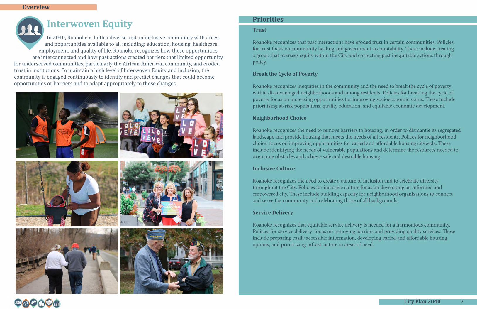
Trust
Roanoke recognizes that past interactions have eroded trust in certain communities. Policies for trust focus on community healing and government accountability. These include creating a group that oversees equity within the City and correcting past inequitable actions through policy.
Break the Cycle of Poverty
Roanoke recognizes inequities in the community and the need to break the cycle of poverty within disadvantaged neighborhoods and among residents. Policies for breaking the cycle of poverty focus on increasing opportunities for improving socioeconomic status. These include prioritizing at-risk populations, quality education, and equitable economic development.
Neighborhood Choice
Roanoke recognizes the need to remove barriers to housing, in order to dismantle its segregated landscape and provide housing that meets the needs of all residents. Polices for neighborhood choice focus on improving opportunities for varied and affordable housing citywide. These include identifying the needs of vulnerable populations and determine the resources needed to overcome obstacles and achieve safe and desirable housing.
Inclusive Culture
Roanoke recognizes the need to create a culture of inclusion and to celebrate diversity throughout the City. Policies for inclusive culture focus on developing an informed and empowered city. These include building capacity for neighborhood organizations to connect and serve the community and celebrating those of all backgrounds.
Service Delivery
Roanoke recognizes that equitable service delivery is needed for a harmonious community. Policies for service delivery focus on removing barriers and providing quality services. These include preparing easily accessible information, developing varied and affordable housing options, and prioritizing infrastructure in areas of need.
Interwoven EquityIn 2040, Roanoke is both a diverse and an inclusive community with access
and opportunities available to all including: education, housing, healthcare, employment, and quality of life. Roanoke recognizes how these opportunities
are interconnected and how past actions created barriers that limited opportunity for underserved communities, particularly the African-American community, and eroded trust in institutions. To maintain a high level of Interwoven Equity and inclusion, the community is engaged continuously to identify and predict changes that could become opportunities or barriers and to adapt appropriately to those changes.
Priorities

City Plan 2040 9
Overview
WellnessRoanoke recognizes that all aspects of health need to be addressed in order to improve the quality of life for all members of the community. Policies for wellness focus on proactively addressing mental, physical, and social health. These include providing for community centers and recreational facilities, health education, and resource facilities.
SafetyRoanoke recognizes the physical safety of its residents and visitors is of utmost importance. Policies for safety will focus on the built environment along with City services and amenities. These include safe streets for all modes of transportation, crime prevention, and improved social connections.
Access to Health and Support ServicesRoanoke recognizes that substance abuse is a national health epidemic that is strongly tied to mental health. Policies for access to health and support services focus on increasing the resources available and community education. These include supporting medical and rehabilitation facilities, discussing mental health and substance abuse openly, and encouraging educational programs.
Access to Affordable Healthy FoodRoanoke recognizes that many of its communities are located in a food desert and may not have access to fresh healthy foods. Policies for access to affordable healthy food focus on creating partnerships to increase the availability of such foods and incentivizing their purchase. These include encouraging healthy eating through the school system, promoting existing food programs, and considering new incentives.
Healthy CommunityIn 2040, Roanoke engages a holistic and equitable approach to building and
ensuring the physical and mental health of our community by empowering citizens with the knowledge and resources to achieve healthy living and to
strive for accountability as individual members of a connected society.
Priorities

City Plan 2040 11
Overview
Sustainable Land DevelopmentRoanoke recognizes the need for more thoughtful land development. Policies for sustainable land development focus on promoting sustainability and resiliency in development standards.
Tree StewardshipRoanoke recognizes the vital services that trees provide to the community. Policies for tree stewardship focus on increasing local education on the natural services provided by trees and protecting, nurturing, and expanding the tree canopy.
Water Resource ManagementRoanoke recognizes that there are increased risks for flooding and pollution of local waters. Policies for water resource management focus on maximizing efforts to reduce flooding and impediments to local rivers and tributaries.
Clean Energy and TransportationRoanoke recognizes that sustainable energy provision and transportation improves human and environmental health. Policies for clean energy and alternative transportation focus on improving options for renewable energy and infrastructure for different modes of transportation, such as biking and public transit.
Outdoor RecreationRoanoke recognizes that outdoor recreation is vital to the regional economy. Policies for outdoor recreation focus on protecting natural assets and promoting outdoor recreation as a health and tourism driver.
Clean and Beautiful CityRoanoke recognizes that a clean, well-maintained environment helps to improve quality of life. Policies for clean and beautiful city focus on upholding an aesthetic that creates a sense of pride in all residents.
Green ConvenienceRoanoke recognizes that more sustainable choices will need to be made in order to combat climate change. Policies for green convenience focus on making it easier for residents to make sustainable choices through education, incentives, and partnerships.
Harmony with NatureIn 2040, the City of Roanoke will boast a clean, resilient environment in
which everyone will live and prosper in harmony with nature through innovative, sustainable, and resilient practices that nurture community health,
embrace recreational opportunities, protect our natural resources, address the local aspects of climate change, support ecosystem services, and foster appreciation and understanding of the City’s relationship with its natural surroundings.
Priorities

City Plan 2040 13
Overview
Growth Through Preservation and Context Sensitive DesignAs a steadily growing city, Roanoke recognizes the need to plan for increasing population. Policies for growth focus on compact development that takes into account surrounding neighborhood patterns and nearby natural assets.
Complete NeighborhoodsRoanoke recognizes the importance of neighborhoods that provide safe and convenient access to necessary goods and services. Policies for complete neighborhoods focus on pedestrian and bicycle access to daily needs for people of all ages and abilities.
Interactive SpacesRoanoke recognizes that vibrant spaces create a sense of community and social interaction. Policies for interactive spaces focus on creating physical, public places for people to come together.
HousingRoanoke recognizes the need for housing in a range of types and levels of affordability. Policies for housing focus on meeting the future needs of a growing and diverse population.
Arts and CultureRoanoke recognizes the value of arts and culture for the community and the economy. Policies for arts and culture focus on highlighting local art citywide in everyday design.
Interconnected Transportation SystemRoanoke recognizes the need to cooperate with regional partners to improve transit. Policies for an interconnected transportation system focus on improving transportation connections and options.
Complete streetsRoanoke recognizes the need for streets that are safe for all users. Policies for complete streets focus on improved infrastructure and education on all modes of transportation, such as bicycling and walking.
Improve InfrastructureRoanoke recognizes the need for infrastructure that allows all areas of the community to grow and develop. Policies for improving infrastructure focus on equitable expansion of service and regular maintenance.
Livable Built EnvironmentIn 2040, Roanoke is a growing, historic cultural hub with vibrant
neighborhoods for all; housing that is safe, accessible, affordable, and varied; advanced technology to provide access opportunities for all; and an integrated
multi-modal, user-friendly transportation system.
Priorities

City Plan 2040 15
Overview
Regional CollaborationRoanoke recognizes that its individual success depends much on the success of our region and neighboring localities. In order to continue growing and thriving, Roanoke recognizes the importance of having a marketable regional identity, good relationships with neighboring localities, and coordinated amenities. Policies for regional collaboration include improving connections between governments, promoting regional assets such as outdoor recreation, and pursing opportunities to collaborate on public services.
Plan and Think RegionallyRoanoke recognizes the benefits of harmonizing planning efforts. Policies for planning and thinking regionally focus on pursuing opportunities for partnerships through regional planning efforts. Areas of opportunity include land use, housing, transportation, economic development, public services, and civic amenities.
Responsible RegionalismIn 2040, the region will plan, act, and promote itself cohesively, with
consideration of each community’s political autonomy and social identity. Each community lends its unique assets and resources to developing the
region’s economy and quality of life. The region will work together to provide exceptional educational opportunities and public services. The region will see more success because it began to compete economically as a unified entity.
Priorities

City Plan 2040 17
Overview
Promote Broad Diversity in EconomyRoanoke recognizes that having a wide range of industries creates a more stable and resilient economy. Policies for creating a more diverse economy focus on being proactive in market research, capitalizing on local assets, and supporting local industries.
Establish Stronger Economic Ties to our Regional PartnersRoanoke recognizes that local business is part of a larger economy connected to regional partners. Policies for establishing stronger regional economic ties focus on leveraging nearby higher education institutions, working with local tourism agencies, and creating relationships with various public and private partners.
Conversion of Underperforming Commercial and Industrial AreasRoanoke recognizes that it is limited in land that can be newly developed, but rich in properties that have the potential to be redeveloped. Policies for conversion of underperforming areas focus on identifying viable opportunities, providing incentives, and connecting buyers to sellers.
Local Business DevelopmentRoanoke recognizes the importance of providing resources to help create and expand local business. Policies for local business development focus on increasing outreach for current resources and providing for new business support services.
Align Economic Development with Workforce Development SystemsRoanoke recognizes the need for a strong, skilled workforce in the current economic environment. Policies for workforce development focus on outreach, talent connection, and training.
Support Local Community Development Roanoke recognizes the benefits of supporting local businesses and partners that invest in the community. Policies for supporting local community development focus on celebrating partners that support local development initiatives, encouraging community support programs, and providing education about these programs.
Resilient EconomyIn 2040, Roanoke’s economy will continue its sustainable growth through
the recruitment of a diversity of industry, revitalization of under-performing and underutilized commercial spaces, support of local business, and continued
partnerships with players who value, support, and celebrate each other’s successes. Our economy will be built on strong collaboration that promotes workforce development for those of all backgrounds.
Priorities

City Plan 2040 19
Authentic ParticipationThe most important step in any planning process involves collaborating with members of the community. Without listening and gaining an understanding of community needs and values, it is impossible to develop a meaningful plan.
Authentic participation requires not only meaningful involvement with citizens throughout the planning process, but the empowerment of citizens to become driving forces within their own communities. To “ensure that the planning process actively involves all segments of the community in analyzing issues, generating vision, developing plans, and monitoring outcomes”, the American Planning Association identifies seven actions in their Best Practices for Comprehensive Plans. These include:
1. Engage stakeholders at all stages of the planning process.2. Seek diverse participation in the planning process.3. Promote leadership development in disadvantaged communities through the
planning process.4. Develop alternative scenarios of the future.5. Provide ongoing and understandable information for all participants.6. Use a variety of communications channels to inform and involve the community.7. Continue to engage the public after the comprehensive plan is adopted.
To achieve the seven recommended actions, citizens and stakeholders were engaged throughout plan development. Varying outreach methods were used to contact all communities within Roanoke in an effort to reach diverse participants. Planning staff relied on those already engaged to act as representatives and recruit others from their community into the planning process. Specific meetings were held to address equity and hard-to-reach areas. Updated information was continually provided in the form of reports, speakers, and events throughout the creation of City Plan 2040 to help residents create their vision for the City’s future.
Kickoff: January 2018The comprehensive planning process began in January 2018. The first phase involved creation of a website, PlanRoanoke.org, to engage and inform the public throughout the two-year process. PlanRoanoke.org would serve as a two-way platform for the planning department and public to communicate on planning initiatives. A community forum and mapping exercise to identify strengths, opportunities, and weaknesses were available on the website.
Love Letters: July 2018The third phase of planning process, referred to as the listening phase, was entirely dedicated to public engagement. The phase was kicked off in July with a presence at the Deschutes Street Pub. Attendees were able to stop at the Roanoke City booth and write Love Letters that identified what residents loved about Roanoke, and what could be improved. During the month, planning staff also engaged with visitors to Market Square in downtown to find out what they envisioned for Roanoke in 2040. A video capturing these responses was posted to the website, along with a community survey.
Open House Meetings: August 2018The survey was promoted at each of the ten open house meetings held in August 2018. Meetings were conducted at various times and dates at each of the neighborhood libraries in order to meet the varying needs of the public. Planning Staff worked closely with the City’s Neighborhood Services Coordinator to notify neighborhood organizations and attended various neighborhood meetings, including that of the Roanoke Neighborhood Advocates. Local news stations and newspapers
advertised the meetings, along with online posts on Facebook and planroanoke.org. Community meetings were designed to engage attendees in future visioning and prioritization of community needs. A mapping analysis identical to the one found on the website and activities for children were set up to involve different age groups. Over 200 people attended the open house meetings and over 1200 responded to the survey. An analysis of responses provided by the public can be found in the Community Response Report.
Youth Outreach: September - October 2018To better engage with youth in the community, the planning staff attended additional student events. Staff hosted a mapping event at the Roanoke Youth Summit in September. Middle and high school students engaged in a collaborative art project adapted from the public meeting mapping activity. Elementary school students participated in the planning process at Highland Park Elementary’s Healthy Choices/Safe Community Day in October. Students created interpretations of their community with drawings and building block models.
Working Groups: November 2018 - March 2019While it is the job of City Planners to use data, public input, and other mandates to create plans, the vision and directive of those plans should be crafted by the community. Open House Meetings were conducted to identify the overall community vision. The next step would be for citizen working groups to identify the needed priorities and policies for achieving said vision. A working group

City Plan 2040 21
Authentic Participationorganizations, local investors, and other community players. Stakeholders reviewed the working group drafted policies amended to include comments from the public meetings. Stakeholders were able to use their expertise in refining the policies and providing additional perspectives and insights – refining and adding to the civic voice.
Stakeholder list:• Roanoke Outside• Blue Ridge Land Conservancy• Western Virginia Water Authority• Friends of the Blue Ridge• Sierra Club• Roanoke Parks and Recreation
Department• Roanoke Urban Forestry Department• Roanoke Sustainability Department• Roanoke Environmental Administrator• Greenways Coordinator• Greenways Commission• Roanoke Stormwater Division• Hist Re Partners• Bill Chapman Inc.• Roanoke Regional Partnership• Virginia’s Blue Ridge• Williamson Road Business Association• Green Home Solutions• Roanoke Transportation Division• Hill Studios• Taubman Museum• Roanoke Valley-Alleghany Regional
Commission• Roanoke Regional Chamber of Commerce• Social Services• LEAP for Local Food• Mental Health America of Roanoke Valley• Rescue Mission• Local Office on Aging• Apple Ridge Farm• JP Powell
was created for each theme, composed of interested community members that signed up through the website or during the open house meetings. Groups were composed of members with varying expertise, including healthcare workers, former public employees and city planners, a community resources officer, local food advocates, neighborhood leaders, small business owners, community activists, equity and inclusion champions, and more. Groups met from November 2018 to March 2019 and identified the top priorities, as well as policies for each theme area of the plan. Over the months, the number of attendees fluctuated as new members were added by recommendation or through further public outreach. To further advise policy development, informative speakers attended discussions to answer questions and provide their expertise. Speakers included the City’s Stormwater and Economic development departments, Transportation Division, along with other field experts like Changelab, Roanoke College faculty and Carilion.
Equity Meetings: March - May 2019Interwoven Equity saw the largest increase in members in a push to create a group representative of Roanoke’s diversity. Four additional meetings on equity were scheduled to increase engagement in needed parts of the community. Meetings took place during evening hours and in targeted areas, many with predominately black residents or with a history of government distrust. These meetings identified critical goals for improved equity and communication with City government.
Open House Meetings: March - April 2019Finalized priorities and policies from the working groups were presented to the public for vetting and further discussion to ensure that community voices were heard. Open house meetings were once again scheduled at all the neighborhood libraries at varying times at the end of March through early April. Attendees had the opportunity to review each group’s findings, and engage in discussion with working group members and City staff. A survey replicating the meeting structure was posted online and advertised for those unable to attend.
Stakeholder Meetings: April - October 2019Following the open house meetings, stakeholder interviews were held with 39 groups and individuals from April to October. Planning staff met with stakeholders from various backgrounds that had strong interest and specialized knowledge in the theme area. These stakeholders included nonprofits, community leaders, government
• Hurt Park Neighborhood Association• Soul Sessions• Roanoke Fire Department• Roanoke Police Department• Blue Ridge Interagency Council on
Homelessness• Council of Community Services• Roanoke City Public Schools• Roanoke Regional Airport• LGBTQ+ Collaborative Group
During this time, additional outreach efforts were conducted. City staff attended Roanoke City’s Youth Summit and Green Academy in September to talk about the Comprehensive Plan. November included the launch of a City Plan 2040 Art Contest, as well as participation in Junior Achievement’s JA in a Day program.
Welcoming Roanoke: May 2019- March 2020The Welcoming Roanoke Plan is the City’s plan for integration that highlights and enhances the economic contributions immigrants make to the community. Through a grant with Welcoming America and New American Economy, Roanoke received technical assistance with plan development. The planning process for Welcoming Roanoke overlapped with that of City Plan 2040, with an increased focus on the refugee population. The kickoff for the Plan was held in May, with a public meeting to share data from New American Economy and an address from Mayor Lea. Outreach for the Welcoming Roanoke Plan included participation in the Local Colors Festival, Welcoming Week, and a survey. One of the most active partners in outreach was the Refugee Dialogue Committee, a local group made of various agencies serving the refugee population. Planning Staff continues
Partner Projects
ChangeLab Solutions is a national organization that advances equitable laws and policies to ensure healthy lives for all. Changelab, along with Roanoke College’s Center for Community Health and Innovation and Freedom First Credit Union, has been working with planning staff to create The Roanoke Valley Community Healthy Living Index. The index identified health disparities and areas of need within Roanoke. This data along with technical assistance provided by Changelab and the New York Academy of Medicine helped the City conduct a public deliberation to inform selection of the City’s next Target Area.

City Plan 2040 23
Authentic ParticipationInto the Future
Authentic participation will continually be an essential element in the planning process. City planners cannot plan for the community without knowing what the community wants and needs. To improve engagement and empower citizens, City Plan 2040 recommends several measures to create new, community represented commissions and groups to ensure equity and public oversight in future decision-making. Additionally, the Plan will be revisited every five years by planners and citizens in order to ensure accountability and track progress.
Several plans are recommended as part of City Plan 2040 with a focus on equity and integration. These plans, along with specialized Neighborhood Plans, will accompany and expand on the goals of the comprehensive plan. Each of these plans will involve a vigorous public component, relying on community leaders and organizations to achieve maximum public participation.
In order to build capacity for the public to participate in planning and other civic processes, the City is working to increase educational opportunities. Courses like Roanoke’s Leadership College, Planning Academy, and Green Academy aim to provide citizens with the tools and knowledge to navigate public processes and use them for community empowerment.
to consult with the Committee and attends their bi-monthly meetings.
Advisory Committee: November - December 2019Planning staff then gathered to incorporate public recommendations. The revised information was presented to an advisory committee. Members of the advisory committee were selected from the six working groups based on their passion and expertise in each of the theme areas. The committee met from November to December to review priorities and policies for each theme. The comments from the advisory committee were incorporated and provided to the public again in February 2020, before final plan revision and adoption. The Advisory Committee’s work was presented to the city’s Planning Commission in a series of work sessions in January 2020.
City Plan 2040 Art Contest: November 2019 - March 2020A City Plan 2040 Art Contest was developed to engage older students. Advanced photography students from both Patrick Henry High School and William Fleming High School participated. Students were asked to create pieces that aligned with one of the six comprehensive plan themes. Three winners were chosen from each class and received certificates, gift cards, and recognition of their outstanding performance.
Open House Meetings: February - June 2020An open house meeting was held at the end of February for City staff. Staff members from departments across the City were invited to attend. The Staff Open
House was promoted through the city’s department directors and leadership team as an opportunity to vet ideas and identify missing elements before final public review.
Public open house meetings were planned for the end of March to review final policies. Unfortunately, the Coronavirus Pandemic prevented such gatherings. In order to still receive public input, a virtual meeting was set up on planroanoke.org. Through this meeting, a draft of the City Plan 2040 web-based document was presented with priorities, policies, and actions. Each section was followed by a public comment box. Participants were directed to contact staff regarding additional questions about each section of the plan. Printed copies of the draft were available upon request for those unable to access the draft via the website.
The virtual meeting was open from April to June and promoted through social media outlets including Instagram, Facebook, and various email listservs. Over 1,200 individuals were reached through Facebook posts and the entire Roanoke City staff was notified via an employee newsletter. The virtual meeting page received approximately 350 visitors. The public provided responses for each section presented, with Healthy Community receiving the most comments.
Comments from each meeting held from February to June were addressed through staff revisions.

City Plan 2040 25
Big IdeasCity Plan 2040 broadly covers a wide range of topics to help us reach our community goals and aspirations. To identify these goals we worked through an intensive public engagement process and then established community working groups to identify priorities, policies and actions in each of the City Plan 2040 theme areas.
We learned from the working group process that there are eight big ideas that need to be developed and addressed in City Plan 2040. These can be broken into three categories. We also identified two big ideas for how we can improve the way the city conducts its business.
Category 1: Physical Development of Our Community
The physical development of a city represents the traditional content of a comprehensive plan, including how land is used and developed. As would be expected, City Plan 2040 has big ideas related to these traditional planning elements.
Complete Neighborhoods Every neighborhood should offer a wide range of housing options within or in close proximity to commercial areas that provide services, retail, and restaurants; schools and child care, places of worship; and parks and open space. These complete neighborhoods are served and connected by an effective multimodal transportation system.
Missing Middle HousingSuccessfully providing complete neighborhoods relies on a range of housing types, compatible with the single family housing found in most neighborhoods. These housing types are often referred to as middle housing. Middle housing may include duplexes or triplexes, accessory dwelling units (an apartment in a basement or above a garage), or small-scale apartments. The beauty of this middle housing is that it can provide alternatives to single-family dwelling for young residents starting out, small options for a young family, or options for older residents looking to down-size but stay in their neighborhood. Unfortunately, many neighborhoods in the city are missing this middle housing. This needs to change to build strong and inclusive neighborhoods.
Neighborhood CentersA complete neighborhood needs one or more centers containing a mixture of higher-density residential uses and neighborhood commercial uses. These centers serve as the focus of neighborhood activity and may vary in size and scale depending on the nature of uses and size of the surrounding neighborhood. Smaller village centers are often contained within a single block, while larger centers may have a mix of retail and office space and are anchored by larger institutions such as churches or schools.
Category 2: Our Environment and Economy
The second category is the environment and our economy. It is clear that our ability to grow our economy is closely tied to creating resiliency and maintaining a high quality of life. For Roanoke, that includes using our local talent and resources while protecting our beautiful valley and surroundings.
Economic Development from WithinIn addition to recruiting employers or potential employees from outside the area, we will focus on:
• Using existing resources and networks to grow small business.• Adapting and expanding job training programs to provide opportunities for jobs that
support a living wage.• Investing in underused corridors and areas to create job training and employment
opportunities close to or within our complete neighborhoods.
Using our Land BetterThe city has limited land available and it must be used better than it has in the past for us to continue to grow complete neighborhoods, provide good jobs close to or within those neighborhoods, and to create an attractive community that we will all love and enjoy.
Environmental Sustainability and ResiliencyAs the city grows, we need to ensure that an emphasis is placed on protecting our air, waterways, and other natural assets. New development should be energy efficient and resilient to account for more intense rainfall and other effects of climate change. The city will support efforts to recognize the beauty of our city and make it easy for our citizens to make sustainable choices.
Category 3: Our People
Our people, the City’s most important resource. Reinforced by events of the last few months, Covid-19 and long overdue attention being drawn to systemic racism in our country, a renewed focus is being placed on the well-being of our community.
EquitySystemic racism has been a part of this country for centuries and persists today. City programs, regulations and policies must be evaluated to remove barriers and to make sure all residents have access to the services that they need. Equity must be considered in all new programs, policies, and rules. Part of this effort includes creating an equity commission to help guide the City.
City Plan 2040 27
Big IdeasCommunity HealthIn 2020, our nation and our City face a daunting public health crisis. Addressing this crisis is complex and the City must first define its role amid a myriad of healthcare providers and organizations. Key actions to support community health include:
• Working to make sure all citizens feel safe in their neighborhood.• Improving access to healthy food and community facilities.• Changing the narrative on how we view homelessness, addiction, and mental health
to remove stigma and promote better care.
Category 4: How the City Conducts Business
We have also heard that the City needs to evaluate how it does business.
Accessible Resources and Information The City provides or supports wide ranging programs from fire protection, infrastructure maintenance, business assistance, to after school programs. Providing readily accessible and well organized information on these resources is important for our residents and businesses.
Provide the Right Services in the Right Places The City needs to make sure the programs and resources it provides are in line with community needs and that those programs and resources are targeted where they are needed most.
There is much work to be accomplished over the next 20 years to advance these big ideas. Important priorities, policies and actions are identified in City Plan 2040 to move these big ideas forward and to transform Roanoke. Working together as a community we can make that transformation happen.

City Plan 2040 29
Themes
City Plan 2040 is guided by six themes drawn from the American Planning Association’s (APA) Best Practices for Comprehensive Plans. The APA identified six principles necessary to ensure a sustainable community. This plan extends those principles into themes that target pressing community concerns, while anticipating Roanoke’s future needs. These themes will ensure a holistic planning approach that addresses environmental, social, and economic well-being.
Each theme consists of priorities, policies, and actions. The plan’s priorities are the most prominent areas of concern identified by the community. The plan’s policies create a decision-making guide to address each priority. The plan’s actions are specific steps needed to implement each policy and achieve the long-term vision of City Plan 2040.
In 2040, Roanoke is both a diverse and an inclusive community with access and opportunities available to all including: education, housing, healthcare, employment, and quality of life. Roanoke recognizes how these opportunities are interconnected and how past actions created barriers that limited opportunity for underserved communities, particularly the African-American community, and eroded trust in institutions. To maintain a high level of Interwoven Equity and inclusion, the community is engaged continuously to identify and predict changes that could become opportunities or barriers and to adapt appropriately to those changes.
In 2040, Roanoke engages a holistic and equitable approach to building and ensuring the physical and mental health of our community by empowering citizens with the knowledge and resources to achieve healthy living and to strive for accountability as individual members of a connected society.
In 2040, the City of Roanoke will boast a clean, resilient environment in which everyone will live and prosper in harmony with nature through innovative, sustainable, and resilient practices that nurture community health, embrace recreational opportunities, protect our natural resources, address the local aspects of climate change, support ecosystem services, and foster appreciation and understanding of the City’s relationship with its natural surroundings.
In 2040, Roanoke is a growing, historic cultural hub with vibrant neighborhoods for all; housing that is safe, accessible, affordable, and varied; advanced technology to provide access opportunities for all; and an integrated multi-modal, user-friendly transportation system.
In 2040, the region will plan, act, and promote itself cohesively, with consideration of each community’s political autonomy and social identity. Each community lends its unique assets and resources to developing the region’s economy and quality of life. The region will work together to provide exceptional educational opportunities and public services. The region will see more success because it began to compete economically as a unified entity.
In 2040, Roanoke’s economy will continue its sustainable growth through the recruitment of a diversity of industry, revitalization of under-performing and underutilized commercial spaces, support of local business, and continued partnerships with players who value, support, and celebrate each other’s successes. Our economy will be built on strong collaboration that promotes workforce development for those of all backgrounds.
City Plan 2040 31
Themes
The intent of this plan is to ensure equity in our policies as they relate to race, ethnicity, age, gender, gender identity, disability, sexual orientation, and any other characteristics upon which people are discriminated against, oppressed, or disadvantaged. This plan dedicates most discussion to racial equity because of its profound impact on the physical development of the City.
A History of Inequity
Any conversation on equity must acknowledge racist policies that existed throughout the country and were present here in Roanoke. While openly racist laws may have come and gone, implicit or proxy policies took their place and some have yet to be completely left behind. The consequences of these policies are still felt today, manifested in de facto housing segregation along with persistent disparities in income, education, employment, incarceration rates, community health, and a pronounced wealth gap.
Throughout much of the 20th century, African Americans were subjected to a coordinated effort of government and real estate interests that limited where they could live. Jim Crow laws started spreading through the south just as Roanoke was incorporated in 1882. In 1911, Roanoke adopted residential segregation ordinances that remained in place for years until a 1917 Supreme Court
In 2040, Roanoke is both a diverse and an inclusive community with access and opportunities available to all including: education, housing, healthcare, employment, and quality of life. Roanoke recognizes how these opportunities are interconnected and how past actions
created barriers that limited opportunity for underserved communities, particularly the African-American community, and eroded trust in institutions. To maintain a high level of
Interwoven Equity and inclusion, the community is engaged continuously to identify and predict changes that could become opportunities or barriers and to adapt appropriately to those changes.
Interwoven Equity
Defining Equity
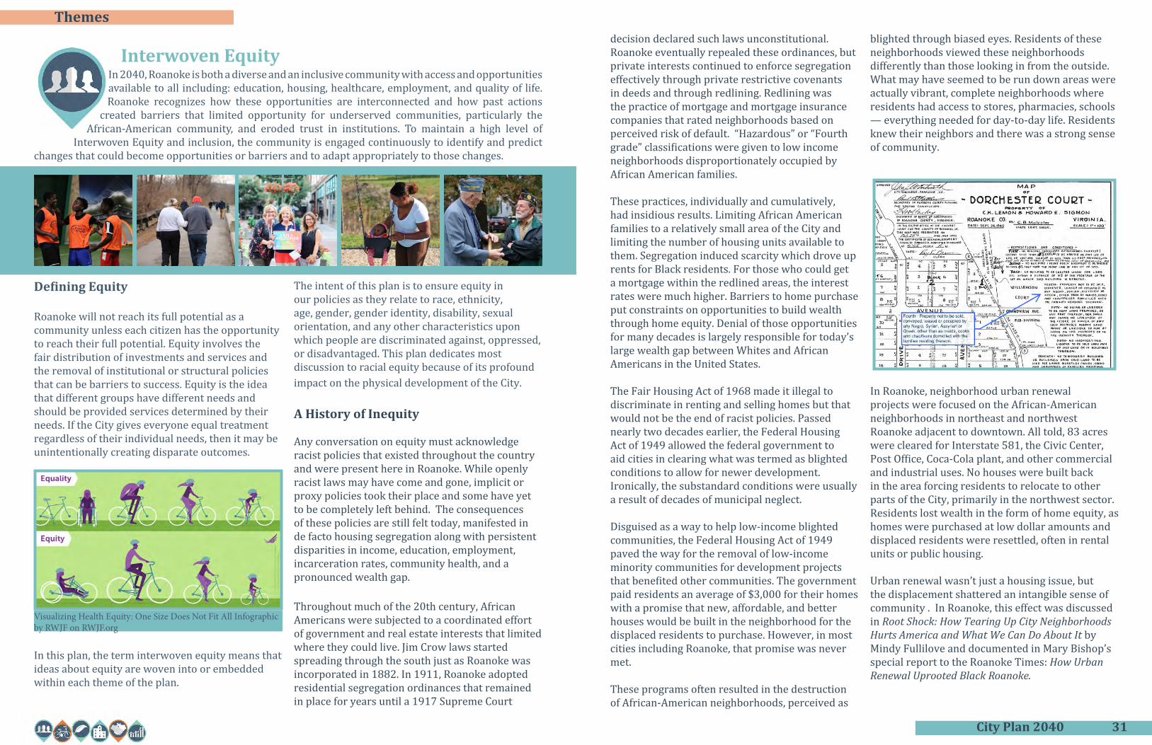
Roanoke will not reach its full potential as a community unless each citizen has the opportunity to reach their full potential. Equity involves the fair distribution of investments and services and the removal of institutional or structural policies that can be barriers to success. Equity is the idea that different groups have different needs and should be provided services determined by their needs. If the City gives everyone equal treatment regardless of their individual needs, then it may be unintentionally creating disparate outcomes.
In this plan, the term interwoven equity means that ideas about equity are woven into or embedded within each theme of the plan.
decision declared such laws unconstitutional. Roanoke eventually repealed these ordinances, but private interests continued to enforce segregation effectively through private restrictive covenants in deeds and through redlining. Redlining was the practice of mortgage and mortgage insurance companies that rated neighborhoods based on perceived risk of default. “Hazardous” or “Fourth grade” classifications were given to low income neighborhoods disproportionately occupied by African American families.
These practices, individually and cumulatively, had insidious results. Limiting African American families to a relatively small area of the City and limiting the number of housing units available to them. Segregation induced scarcity which drove up rents for Black residents. For those who could get a mortgage within the redlined areas, the interest rates were much higher. Barriers to home purchase put constraints on opportunities to build wealth through home equity. Denial of those opportunities for many decades is largely responsible for today’s large wealth gap between Whites and African Americans in the United States.
The Fair Housing Act of 1968 made it illegal to discriminate in renting and selling homes but that would not be the end of racist policies. Passed nearly two decades earlier, the Federal Housing Act of 1949 allowed the federal government to aid cities in clearing what was termed as blighted conditions to allow for newer development. Ironically, the substandard conditions were usually a result of decades of municipal neglect.
Disguised as a way to help low-income blighted communities, the Federal Housing Act of 1949 paved the way for the removal of low-income minority communities for development projects that benefited other communities. The government paid residents an average of $3,000 for their homes with a promise that new, affordable, and better houses would be built in the neighborhood for the displaced residents to purchase. However, in most cities including Roanoke, that promise was never met.
These programs often resulted in the destruction of African-American neighborhoods, perceived as
blighted through biased eyes. Residents of these neighborhoods viewed these neighborhoods differently than those looking in from the outside. What may have seemed to be run down areas were actually vibrant, complete neighborhoods where residents had access to stores, pharmacies, schools — everything needed for day-to-day life. Residents knew their neighbors and there was a strong sense of community.
In Roanoke, neighborhood urban renewal projects were focused on the African-American neighborhoods in northeast and northwest Roanoke adjacent to downtown. All told, 83 acres were cleared for Interstate 581, the Civic Center, Post Office, Coca-Cola plant, and other commercial and industrial uses. No houses were built back in the area forcing residents to relocate to other parts of the City, primarily in the northwest sector. Residents lost wealth in the form of home equity, as homes were purchased at low dollar amounts and displaced residents were resettled, often in rental units or public housing.
Urban renewal wasn’t just a housing issue, but the displacement shattered an intangible sense of community . In Roanoke, this effect was discussed in Root Shock: How Tearing Up City Neighborhoods Hurts America and What We Can Do About It by Mindy Fullilove and documented in Mary Bishop’s special report to the Roanoke Times: How Urban Renewal Uprooted Black Roanoke.
Visualizing Health Equity: One Size Does Not Fit All Infographic by RWJF on RWJF.org

City Plan 2040 33
Themesmaking and policy making are based on principles of equity and are examined for bias and potential unintended consequences for any specific group of people. To that end, five priorities emerged:
• Trust• Break the Cycle of Poverty• Neighborhood choice• Inclusion Culture• Service Delivery
Welcoming Roanoke
As the city moves forward, it is vital that we project an atmosphere of inclusiveness to lifelong residents and newcomers. The Welcoming Roanoke Plan addresses how we can better serve new residents in our city and gives the city a roadmap to creating a welcoming city for all including immigrants and refugees. While the Welcoming Roanoke Plan is a separate document, the spirit of being a welcoming city is present throughout this plan.
Moving Forward as an Equitable City
The consequences of segregation laws, real estate practices, and urban renewal are evident today, not just in the City’s development patterns physically, but also socially, economically, and psychologically. Today, consequences are manifested in identifiable neighborhood patterns that show worse health outcomes, less economic mobility, poorer education levels, and lower employment.
Those disparate outcomes are pronounced in the African American communities located in the northwest quadrant of the City. However, these disparate patterns of health outcomes, economic mobility, educational attainment and employment are not isolated to those neighborhoods.
As a community, we must understand how intentional practices created barriers to the success of African Americans and other residents of Roanoke. As we learn and reconcile these inequities, we must also look forward to how we can apply these lessons to all individuals regardless of race, ethnicity, age, gender, gender identity, disability, sexual orientation, and any other characteristic upon which people are discriminated against, oppressed, or disadvantaged.
As the City continues to grow and becomes increasingly more diverse, we must understand the needs and concerns of all residents and strive to build trust, support upward mobility, remove barriers affecting neighborhood choice, champion an inclusive community, and provide services equitably.
Interwoven Equity is the idea that decision

City Plan 2040 35
Themes
Priority One: Trust
While overtly discriminatory policies of the past have largely been removed, there is still a responsibility for City government and its current leadership to regain trust following the trauma experienced by African American communities. For the community to thrive as a whole, the City government must work to build trust through its actions.
Policy 1: Remove legal elements of institutional or structural bias
Action Items:• Review and eliminate City codes and policies based on explicit or implicit biases, and
advocate the same approach for state laws and policies• Advocate for criminal justice reforms that address systemic and interrelated issues of
our time such as mass incarceration, militarization of police, implicit bias, school–to-prison pipeline, the war on drugs, and mandatory sentencing
• Enable complete neighborhoods to develop within the framework of the zoning code, providing access to affordable housing, services, and employment.
• Ensure the diversity of advisory and decision-making bodies reflects the diversity of Roanoke
Policy 2: Lead community healing
This policy recognizes that healing is a complex, long term process, requiring engagement of Roanoke’s communities to determine meaningful ways to acknowledge past injustices and build trust.
Action Items:• Create an office or Council-appointed commission that evaluates existing and
proposed policies through an equity lens• Initiate community dialog on equity and community issues• Develop an educational component in schools on the historical experience of African
Americans in Roanoke and embrace statewide changes to history curricula that accurately depicts the Civil War and Reconstruction
• Build capacity (ability and experience) for neighborhood-based organizations to carry out or direct appropriate community improvements and services
• Complete visible community-identified public facility improvements to demonstrate commitment, especially those that were previously recommended in neighborhood plans
• Commit to ensuring that the diversity of City staff, commissions, and boards reflects the diversity of Roanoke and require the same of larger community organizations the City supports financially
Interwoven Equity Priorities
Policy 3: Create ongoing advocacy and accountability for equitable government policies
The idea behind this policy is to embed equity ideas into the institution of local government to ensure that work carries on even as leadership and personnel change.
Action Items:• Create a commission that focuses on evaluating policies through an equity lens• Create equity measures or requirements for each theme within the Comprehensive
Plan and compare with peer cities• Develop an equity lens for policy and regulation review at the staff level and research
best practices to create accountability within government, for example Government Alliance on Race and Equity
• Create an office that coordinates government actions and reviews policy and regulation to determine their effect on equity in the community
• Inventory and report projects completed in CDBG eligible target neighborhoods
Priority Two: Break the Cycle of Poverty
A variety of factors affect people in poverty in ways that make it difficult to break the cycle of poverty. This priority focuses on policies that provide pathways to upward mobility and remove the obstacles that get in the way of success.
Policy 1: Establish neighborhood-adjacent districts as the priority areas for job creation
Many neighborhoods in the core of the City have underused commercial and industrial zones in the neighborhood (for example, Shenandoah Avenue, NW, Campbell Avenue, SE, and Plantation Road, NE). Economic development efforts are often directed toward more remote industrial centers that are less accessible for people. This policy favors turning the focus back to central areas that already have infrastructure in place and are accessible by walking, biking, or transit.
Action Items:• Inventory central area commercial and industrial districts to develop strategies and
incentives for redevelopment• Create accessible information about starting a business• Create programs to facilitate new business startups by local entrepreneurs• Provide incentives for new business development in core districts• Ensure incentives are conditioned on living wage job creation

City Plan 2040 37
Themes
Policy 2: Provide supportive interventions strategically
This policy is about establishing gateways for people to gain access to the best set of resources available to meet their needs. Interventions should be supportive in the sense that they fill an immediate need and should then go further to make sure the support provides for the overall well-being of the individual as they look to improve their immediate situation.
Action Items:
• Support programs that help people deal with multiple issues holistically through referrals to the varied forms of support an individual may need
• Ensure preventive mechanisms are in place for helping at-risk people to prevent more serious issues (e.g., underemployment, homelessness, health issues, and unsafe housing conditions)
• Make gateways to services accessible in neighborhoods (such as in libraries and schools)
• Prioritize employment preparation and workforce development for groups that need more support
• Ensure convenient access to employment networks (build social capital)• Support and improve financial literacy services• Connect the Blue Ridge Interagency Council on Homelessness with the Police and
other City staff to better serve people who are experiencing homelessness
Policy 3: Provide schools that serve low- and moderate-income neighborhoods with additional programs and resources to enable students to perform on equal footing with students in other schools
Education is key to a successful life. As early as third grade, one’s reading level can predict success or failure later in life. At the elementary level, it is vital that all children have access to the same opportunity of learning, but some schools simply have children that face much different obstacles in life than children in other schools.
There is a general pattern of schools that perform poorly because of where the children start in terms of social and economic factors like race, family income, (or both) as well as their home environment. Beyond education fundamentals, schools that serve low to moderate income neighborhoods should emphasize building the self-worth/self-esteem of students and aspire them to seek opportunities in life. Applying the principle of equity would mean those schools get special programs and additional resources to help students succeed.
Action Items:
• Attract and retain highly qualified, diverse teachers who want to teach in an urban environment including recruitment from historically black colleges and universities
• Provide salary incentives to retain talent in schools with greater need• Continue programs that provide focused opportunities to at-risk students• Provide high-quality supportive services in schools (e.g., medical services, mental
health services, nutrition)
Policy 4: Provide quality education for all residents.
Just as the school system provides special programs and additional resources to those students most in need, the school district will also offer top-notch educational opportunities for all residents. High quality school curriculum not only helps support the success of current students but also helps support population and economic growth within the City. In order to increase our working age population, the City must have quality schools that retain families and are competitive regionally.
Action Items:
• Continue our partnerships with institutions of higher learning in our area• Expand opportunities for virtual education to help provide a variety of opportunities
for children• Attract and retain highly qualified administrative leaders and top-notch educators• Strengthen joint partnerships with the Roanoke City Police Department, Sheriff ’s
Department, Roanoke Fire and EMS, Department of Social Services, and mental health agencies to continue to improve safety
• Identify and cultivate collaborative opportunities with businesses, non-profits, community organizations, and faith-based organizations within each school neighborhood
• Support the Roanoke City Public Schools Strategic Plan
“At the beginning of the twenty first century, education is more pivotal than ever in deciding children’s fate. Those with an education have a chance; those without face prison and/or early death. That said, let us acknowledge that it is difficult to educate children living in unstable conditions. This poses a catch-22: we cannot educate children if we do not get them out of unstable conditions, and we cannot get them out of unstable conditions if we do not educate them.” -- Root Shock: How Tearing Up City Neighborhoods Hurts America and What We Can Do About It, Mindy Fullilove (p. 231). Learn more at rootshock.org.

City Plan 2040 39
Themes
Priority Three: Neighborhood Choice
Policy 1: Identify and remove barriers to housing choice
When overt racial segregation laws were struck down in early 20th century, other segregation strategies emerged. A widespread practice by developers placed private restrictive covenants into land deeds to preclude sales to African American people. Owning a single-family house on a large lot was out of reach for many African-American families, so governments began using single-family zoning districts and minimum lot sizes to have the effect of excluding them. Financial policies favoring homeownership emerged as a proxy strategy for legal segregation.
Even though Roanoke became segregated by race and income through intentional policies, reversing those injustices means making sure that barriers to housing choice, including ones that are not readily apparent, are removed.
Action Items:• Reconsider housing policies rooted in racial segregation efforts such as exclusionary
zoning districts that exclude all but single-family houses• Work to reduce tenure bias, that is, the favoring of owner-occupants over renter
occupants, by reviewing City policy and plans to eliminate such bias• Ensure the Fair Housing Board is active in removing barriers by providing community
education, paired testing, and assessment of barriers to housing choice
Policy 2: Understand the connection between finances, housing, and literacy in order to remove barriers for vulnerable people like veterans, homeless people, elderly, domestic violence victims, formerly incarcerated people, and people recovering from addiction
Action Items:• Review and reexamine how and where zoning codes permit group care facilities and
group homes providing housing and supportive services and support distribution of such housing in neighborhood settings dispersed throughout the City
• Continue housing first programs and test other innovative housing approaches• Improve connections among local service providers for the homeless and those
experiencing poverty• Expand/extend after care resources for previously homeless individuals• Inventory the existing group care/transitional living facilities; disperse such facilities
and amend policy as needed to meet the needs of the community• Support and improve financial literacy services• Better promote and improve literacy action
Policy 3: Support the concept of greenlining, or providing special financial resources in neighborhoods that were formerly redlined
The Greenlining Institute promotes greenlining as the solution to redlining. Per their website greenlining.org, they define greenlining as “the affirmative and proactive practice of providing economic opportunities to communities of color.” While greenlining may not undo all the negative impacts experienced as a result of redlining and systemic racism, it is an equitable approach for moving forward.
Action Items:• Assemble a package of greenlining resources such as down payment assistance, access
to fair credit for mortgages, housing finance counseling, and Live Near Your Work incentives
Policy 4: Develop varied and affordable housing options in each neighborhood
Affordable housing is a significant issue in larger cities and will become more of an issue in Roanoke as our population grows and as minimum wages fail to keep pace with inflation. Availability of affordable housing options creates stability for families. When a family has affordable, stable housing, opportunities for employment and education are more easily pursued.
There is a generally accepted principle that no more than one-third of family income should be spent on housing (rent or mortgage). Anything above one-third is considered “cost-burdened.” Families of all incomes have the potential to be cost burdened according to that definition. The problem becomes quite acute for families with lower incomes where little is left over for other necessities after paying rent.
A generally accepted definition of affordable housing is defined as that which can be afforded by a household with the median income for the area. The Housing Affordability Index looks at income ranges that are less than the median income and assesses affordability for, say, a family making only 80% of median household income. Families at this income level, in Roanoke at least, can typically find housing that does not make them cost burdened. Households making 60% of the median, however, will be cost burdened, paying about 40% of their income for housing. Someone making near minimum wage can expect to pay nearly 80% of their income for housing – obviously an unsustainable situation.
Post-WWII Roanoke followed the same housing direction of most communities: growing by adding residential subdivisions oriented to cars, separated from goods and services, and remote from places of employment. This model of suburban sprawl, unsustainable

City Plan 2040 41
Themes
from an environmental standpoint, also has had serious implications for equity. It has led to a concentration of poverty, intensified racial segregation, and limited transportation options for those who do not drive.
We are now seeing fundamental changes in how people live. The endless expansion of single-family residential subdivisions no longer seems sensible given that people are having fewer children and having them later in life and while more people are renting (by choice or not). Cities with one singular resource – land – are questioning the sustainability of low-density residential districts.
Because an in-depth analysis of housing is warranted but typically beyond the scope of a comprehensive plan, such a plan is recommended soon after adoption of this plan.
Action Items:• Develop a housing plan as a component of the comprehensive plan• Ensure affordable housing is available in all neighborhoods in the City• Promote complete neighborhoods, so all neighborhoods have a broad range of
housing types, including multifamily housing• Pursue legislative opportunities to increase affordable housing options and
opportunities• Incentivize housing that is affordable and/or is built with universal design standards
Policy 4: Avoid displacement resulting from gentrification
In community development, there is a complex dilemma: people don’t want their neighborhoods to stay the same or get worse, nor do they want rapidly increasing rents that displace existing residents. Merriam Webster defines gentrification as “the process of repairing and rebuilding homes and businesses in a deteriorating area (such as an urban neighborhood) accompanied by an influx of middle-class or affluent people and that often results in the displacement of earlier, usually poorer residents.” While the first part sounds pretty good, it’s the second part—displacement—that is a worrisome and serious concern.
There has not been any evidence of significant gentrification in Roanoke. Old Southwest is probably the closest Roanoke has come to a gentrifying neighborhood. That transition—which has been taking place gradually over decades—has resulted today in a diverse, mixed income neighborhood.
Action Items:• Maintain vigilance by monitoring data to identify emerging gentrification patterns• Put decision-making about neighborhood improvements at the neighborhood
level. Consider intensive public deliberation processes to determine neighborhood improvement priorities
• Use funds to rehabilitate existing housing stock to help current residents remain in their home
• Support the development or rehabilitation of affordable rental housing• Educate community on the Homestead Exemption law
Priority Four: Inclusive Culture
Policy 1: Lead development of a culture of inclusion throughout Roanoke
The City should lead an effort to foster an environment where community members recognize and celebrate the inherent worth and dignity of all people.
Action Items:• Sponsor opportunities for learning and discussion about the root causes of
discrimination and how to address those issues• Create opportunities for open dialogue among residents from all neighborhoods• Provide educational opportunities to help community leaders become champions in
their communities• Promote dialogue with nonprofits and businesses on equity, diversity, and inclusion• Consider inclusiveness and diversity when programming City-supported events• Engage immigrant and refugee populations in community organizations• Celebrate community successes
Policy 2: Build capacity for community-based organizations to better connect with their residents
Roanoke initiated a neighborhood partnership model in the 1980s that worked to engage community organizations, businesses, and governments. As the model was often cited as a best practice throughout the country, Roanoke’s neighborhoods built a strong network of neighborhood groups actively engaged in improving their communities.
These groups were governed and operated essentially as homeowner associations. In the last decades, those groups have found it increasingly difficult to engage people. Some groups, active and strong through the 1990s, became completely inactive. Others are struggling with dwindling membership.
The reasons are varied. Some with multiple jobs may struggle accomplishing daily tasks and dedicating time to attend neighborhood meetings may be difficult. Social media

City Plan 2040 43
Themes
has radically changed the ways we communicate and the typical monthly meeting may no longer be the best method for engagement. Alas, many neighborhood groups have traditionally held strong biases against renters and thus have alienated a large and growing segment of residents.
The City remains committed to community engagement because it is essential to identifying community needs and developing appropriate interventions to meet them. Radical adaptation of our past model of engagement is warranted.
Action Items:• Provide training on equity and coalition building• Use public deliberation techniques for informed decision making by citizens• Facilitate connections among neighborhood leaders• Continue grant funding to support neighborhood organizations• Develop neighborhood-level capacity to decide and implement neighborhood
improvements• Ensure neighborhood engagement in civic governance
Priority Five: Service Delivery
This priority focuses on services provided by the City of Roanoke. It is crucial that services are provided equitably and in ways that are accessible to all residents.
Policy 1: Provide easily accessible information on community and public services
Discussions during planning meetings revealed that many are not aware of certain community or City services. There was a realization that it is not enough to actually provide services, but ensuring awareness of them is a critical part of service delivery.
Action Items:• Employ best practices to promote available services in order to reach all residents
regardless of age and income• Consider neighborhood-based service information in civic facilities like libraries• Support information and referral programs that help people connect with the
resources they need• Ensure government meetings are accessible at convenient times and there are
accommodations for disabled people, and when appropriate, provide multiple opportunities for engagement by holding multiple meetings in neighborhood settings (such as at libraries), at different times of day
• Provide programs that help educate residents on City services and processes such as the Mayor’s Starting a Business Summit, Leadership College, and the Roanoke
Planning Academy• Develop Spanish language versions of informational programs and online content
Policy 2: Remove barriers to accessing services and programs
The policy approach is to improve service delivery to citizens by enhancing their ability to access the service location or by mobilizing the service to convenient locations.
Action Items:• Ensure services are accessible by transit (i.e., on or near a route)• Provide services in neighborhoods with mobile units or by rotating services among
libraries or other community facilities• Convene community walks with residents and government service providers
to establish communication and information-sharing (e.g., police, fire and EMS, planning/code enforcement, parks and recreation, teachers/school staff, etc.)
Policy 3: Prioritize infrastructure and facility improvements in in areas of need
In determining how limited funding for infrastructure and public facilities is spent, equitable prioritization should ensure that each neighborhood has adequate infrastructure to meet the needs of residents and businesses. Public facilities and infrastructure projects should be used to support overall neighborhood revitalization efforts, especially in target neighborhoods.
Action Items:• Consider CDBG target neighborhoods as priorities for infrastructure improvements
(e.g., sidewalks, curbs, streets, storm drainage, bike lanes, greenways, and street trees)• Consider CDBG target neighborhoods as priorities for improvements to public
facilities (e.g., fire stations, libraries, schools, parks, recreation centers, and other community services)

City Plan 2040 45
Themes
the health in all policies approach as we develop ideas among the different themes of this plan.
Wellness
A holistic view of wellness is needed to assess community health and develop corresponding public policy. The Department of Health and Human Services identifies eight dimensions of health and wellness. Physical health related to exercise, nutrition and rest is the most recognized of these element. Physical health, along with the other elements of emotional, financial, social, spiritual, occupational, intellectual, and environmental health form an interconnected state of wellness. Lack of security in any of these areas can lead to impacts to mental or physical health.
The social and emotional components of wellness can be more difficult to identify and address than the physical ones. Because of their lasting effect on a person’s overall wellbeing, approaching these elements requires persistent and deliberate attention, beginning at an early age. The U.S. Department of Health and Human Services,
In 2040, Roanoke engages a holistic and equitable approach to building and ensuring the physical and mental health of our community by empowering citizens with the knowledge and resources to achieve healthy living and to strive for accountability as individual
members of a connected society.
Healthy Community
Introduction
Community health is a complex issue, one that has not been addressed in past planning efforts. This theme considers wellness in its most broad sense and explores how safety and security, housing, access to food, and access to support services interrelate in ways that shape the health of the community.
Health in All Policies
As we developed City Plan 2040, City staff and partners participated in the Change Lab Solutions’ Building Healthy, Equitable Communities for Children & Families project. This technical assistance project shaped thinking about community health and underscored the importance of considering all the different factors that influence health. Singular focus on a particular factor doesn’t yield the desired improvement in overall community health. The idea that we need to press all the levers of influence at once has spurred progressive communities to adopt a health in all policies approach. Because city planning is so policy oriented, it is appropriate to consider
Substance Abuse and Mental Health Services Administration has extensive tools and resources on multi-pronged, trauma-informed approaches to addressing health issues. The trauma-informed approach recognizes how violence, abuse, neglect, loss, and other emotionally harmful experiences impact health.
When it comes to physical health, obesity and chronic disease, are serious problems in our communities – in some more than others. Chronic diseases, influenced in large part by tobacco use, alcohol abuse, lack of exercise, and poor diet, affect 6 in 10 adults and are a leading cause of death and disability in the U.S. Some 80% of health outcomes are determined by people’s behavior, environment, or social and economic conditions. As might be expected, health outcomes vary widely by neighborhood based upon social and economic conditions.
More recently, mental health and substance abuse issues have gained attention, particularly with the opioid epidemic, highlighting the need for more holistic discussions about health.
Safety
During the listening phase of the planning process, Roanoke residents discussed how transportation, infrastructure, law enforcement, and a sense of community influence community safety and feelings of security. Residents identified safety as both a strength and a challenge for the community. This sentiment was further emphasized in the Healthy Community working group discussions that recognized important linkages between security and
health. For example, regular exercise is a key building block of health, and walking is the easiest form of exercise available to most people. But what if people don’t feel safe going for a walk in their neighborhood or worry about their personal security when they go to a park? Safe Wise’s “State of Safety” reports that 58% of Americans are concerned about their safety at some point of every day. We are all familiar with priorities of preventing safety hazards and preventing crime, but actual and perceived safety can also be created with infrastructure like sidewalks, crosswalks, and bike accommodations on streets.
Safe and Healthy Homes
Good housing is key determinant of good health outcomes. It is important to not just have access to housing, but healthy housing. While most of Roanoke’s housing is well-maintained and healthy, some housing units are not. Census data indicates that about 4% of Roanoke’s housing is substandard and lacks complete plumbing or kitchen facilities. Roanoke’s Office of Real Estate Valuation identified 431 structures that are in poor or very poor condition.
Environmental hazards in some of Roanoke’s older housing stock can be a challenge. Over 80% of homes were built before 1979 and, while historic homes add to the character of the city, some have the potential for lead based paints, asbestos and other materials that are now recognized as health hazards. Until updated, older houses may not have electrical systems suitable for modern appliances or other structural or maintenance issues that represent potential safety hazards.

City Plan 2040 47
Themessiting facilities. People frequently object to treatment or care facilities in their neighborhoods. The equity dimension can be complicated. Facilities are needed and they need to be accessible and they need to be distributed throughout the city.
Access to Affordable Healthy Food
The Kroger and Mick-or-Mack stores that once bristled with activity in neighborhoods like Melrose and Belmont disappeared in the 1990s. Before then, people had the choice to walk or drive to get their weekly groceries. These stores were replaced, however, with larger stores in shopping centers near the outskirts of town. Located far from any residences, they are accessible only by car or bus. Meanwhile, large neighborhood areas are left with no access to groceries within the community. Despite strong community support to attract grocery stores back to neighborhoods, there is little indication that will happen given the scale and markets required. Public intervention in some form may be needed to address this issue.
Suburbanization of grocery stores has led to so-called food deserts in urban neighborhoods. Food deserts lead to food insecurity. The Oxford Dictionary defines food insecurity as “The state of being without reliable access to a sufficient quantity of affordable, nutritious food.” In 2018, 11% of U.S. households experienced food insecurity. Particularly, Virginians have seen a marked increase in the number of low-income individuals with low access to food stores. While many residents are able to drive to pick up groceries, this is especially difficult for vulnerable populations such as low-income people,
The Building Safety Division, the Code Enforcement Division work to improve housing conditions. Improving home and building safety includes consideration of age of housing stock, sanitation, other health risks such as mold, lead and asbestos, and hazards related to building systems (e.g., wiring) to which renters and low-income individuals are especially vulnerable. Community Resources Division through housing rehabilitation projects and programs like Lead SAFE Roanoke have eliminated environmental hazards in hundreds of homes.
Access to Health and Support Services
The percentage of uninsured Americans has increased; 8.5% of people lacked health insurance in 2018. Coinciding with the increase in uninsured individuals, the Medical Expenditure Panel Survey shows that office-based health care is on the decline and the number of people relying on hospitals as a source of care has increased. While the recent expansion in Medicare has aimed to fill these gaps and has provided new access for approximately 9,000 Roanoke residents, access to health care is still an issue for varying reasons, including high cost, inadequate insurance coverage, lack of availability of services, poor provider trust, and lack of culturally competent care. Removing barriers like these would create more equitable access.
Lack of access to health and support services can be even more pronounced for those that are homeless or those that suffer from mental health or substance abuse issues. In addition to barriers associated with cost, insurance, and availability, there is an added barrier to access related to
children, and seniors. Food insecure households are more likely to shop at convenience stores, where healthy food choices are rare or nonexistent.
Health Equity
Perhaps the most important observation about community health is how it varies among different populations. Many of the health factors above merge to create remarkably different health outcomes from one community to another. We see inequity in patterns of life expectancy and disease rates among different neighborhoods, and this is where issues of health and equity intersect. Equitable health outcomes should be the ultimate goal. All policy and action should be oriented to reducing these inequities.

City Plan 2040 49
Contents
Priority One: Wellness
The National Wellness Institute recognizes that “wellness is a conscious, self-directed and evolving process of achieving full potential”, in addition to being “multidimensional and holistic, encompassing lifestyle, mental and spiritual well-being, and the environment”. Achieving this priority requires policies that address each of the many aspects of wellness.
Policy 1: Manage community wellness holistically
Improving public health is a complex endeavor and involves partnerships between the City, health professionals, large and small healthcare providers, non-profit community organizations, businesses, and the City’s residents. Defining the City’s role in this partnership is important and will likely involve the City playing the role of leader, facilitator, communicator and supporter, depending on the situation and circumstance.
Action Items• Adopt a Health in all Policies approach where community health is considered in all
significant policy decisions • Establish an advisory body to guide and assess the City’s policies as they relate to
community health• Develop a community health plan with specific priorities, policies, actions, and data
measurement related to health in the City• Consider representation from health professions on boards and commissions
Policy 2: Provide equitable access to health education, programming, and resources
The community highlighted health access and connectivity during the planning process. The actions of this policy aim to bridge the gap between a wide range of often disconnected resource providers and recipients through increased coordination, access, and education.
Action Items• Create a central resource hub that provides access to health information, tools, and
resources• Initiate community education programs on food preparation, exercise, tobacco
cessation, obesity, diabetes, etc.• Push health services and information out to neighborhoods through mobile events, in
libraries, and at other community facilities
Policy 3: Ensure equitable access to recreational facilities and programming
Healthy Community Priorities
Good access to parks and recreation has a number of benefits including reduced stress, improved mental health, higher physical activity, and lower obesity rates. Creating equitable access to recreation for all parts of the community is one step towards improving overall health.
Action Items• Address age, condition, and equitable distribution of current recreation centers• Facilitate shared use of schools and other institutional facilities for recreational
activities• Provide a comprehensive network of greenways, trails, blueways, and parks
Policy 4: Support social connectivity as a positive health factor
Social connection is a key component for overall health and wellness, specifically among seniors. Increasing social interactions among residents is also part of creating an inclusive culture.
Action Items• Improve opportunities for social connection by providing public gathering spaces• Encourage and enable integration of senior-oriented housing and other group care or
living arrangements in neighborhood settings including co-housing• Partner with local groups and nonprofits to improve social connections and networks
for older adults and disabled populations. Create and support intergenerational social connection through volunteer programs and events
• Support and strengthen neighborhood associations and their efforts for community engagement
Priority Two: Safety
Communities in which residents feel safe and comfortable create an environment where residents can be active, healthy, and thriving.
Policy 1: Policing strategies will approach community safety through research, education, and community collaboration
A study by the U.S. Department of Justice confirmed that informal contact with officers improved community perception of the police. This type of interaction also has the potential to reduce biases held by police officers against community members. Increasing friendly engagements between the community and law enforcement is a step to improving trust within minority and low income areas.

City Plan 2040 51
Themes
Action Items:• Engage communities in developing policing strategies• Improve education for patrol officers through third party training sessions that
address sensitive neighborhood concerns• Use updated data and research to predict problems and incorporate Crime Prevention
Through Environmental Design (CPTED) principles to reduce crime• Continue to use the RCPD RESET Coordinator as a liaison between the police
department and the community• Improve neighborhood contact with the RPD Crime Prevention Unit and encourage
stronger neighborhood watch programs• Institute community walks that include area citizens and an interdisciplinary group
of City service representatives, including city planners, code enforcement, police, fire/ems, and schools
Policy 2: Provide efficient and equitable emergency planning and response
The City’s police, fire and emergency response services are nationally accredited and strive to meet national standards for response time and other performance measures. As the City plans for emergencies, adaptation to a changing environment must be considered along with how responses serve our community in an equitable manner.
Action Items:• Ensure Fire-EMS plans provide for services to meet desired response times and level
of service across the City and address specific needs for vulnerable populations• Update disaster recovery and preparedness plans to consider effects of climate
change• Assess current disaster recovery and preparedness plans for adequate coverage of
vulnerable populations including preparation for emergencies, contingencies for public facility shutdowns, and communication methods during emergencies
• Create a strong communication system with hospitals and health care providers in preparation for pandemics and other public health emergencies
• Continue collaboration between neighboring localities for delivery of Fire and EMS services
Policy 3: Ensure all streets, especially arterial streets, are designed for safe and comfortable walking and biking
Reinforcing the Complete Streets Policy will prioritize safe bicycle connections and pedestrian circulation with access to parks, schools, and other destinations that encourage active living with an emphasis on pedestrian safety. Pedestrian motor vehicle crashes and fatalities are increasing in Virginia. Improving pedestrian safety is important
for creating a healthy community and allowing equitable mobility within the City.
Action Items• Review, update, and readopt the Complete Streets Policy and the Street Design
Guidelines• Consider general reductions in speed limits throughout the City, particularly in
neighborhood settings • Redesign and retrofit streets to encourage slower and more appropriate vehicle
speeds for the context• Improve street lighting as needed to increase the sense of safety and encourage
pedestrian activity• Identify areas with high pedestrian activity in community plans and recommend
appropriate infrastructure such as sidewalks, paths, lighting, and crosswalks to provide pedestrian safety and comfort
Policy 4: Improve home and building safety
Ensure buildings are constructed, retrofitted, and maintained for safe environmental conditions.
Action Items:• Administer building maintenance codes as a remedial strategy for improving building
conditions, and as a preventative strategy to halt further decline of Roanoke’s well-designed but aging residential buildings
• Continue and enhance rehabilitation programs to improve existing housing conditions and construction programs to provide safe new housing in core neighborhoods (such as the various programs provided by the members of the Roanoke Housing Partnership in CDBG target areas)
• Consider new strategies for improving the safety of the City’s residential housing & institutional buildings as health sciences progress
• Raise awareness of household risks through public outreach• Provide funding and incentives for household upgrades that reduce health risks• Consider ways to incorporate energy and environmental quality audits within the
development review process• Assess and improve environmental quality of public and institutional buildings
Priority Three: Access to Health and Support Services
In order to improve access to health care and resulting health outcomes, barriers to health services need to be reduced.
Healthy Community Priorities

City Plan 2040 53
Themes
Policy 1: Family health, mental health, and substance abuse treatment facilities should be considered as essential community needs and location decisions for such facilities should be driven by factors such as scale, geographic distribution, and accessibility Public health concerns like substance abuse, trauma, domestic violence, and homelessness are stigmatized and, to some extent, are even criminalized. This marginalization stands in the way of connecting needs with assistance to manage or resolve such issues. These issues, which virtually every community has, cannot be addressed until they become part of public dialogue.
Action Items• Improve public education of current health resources and develop new support
services• Increase public awareness of domestic violence and other family issues and the
availability of family services• Support development of adequate inpatient and outpatient medical and rehabilitation
facilities for substance abuse or mental health disorders that are small in scale, accessible, and distributed across the City
• Remove barriers to treatment, disease management, and support for those with substance abuse and mental health
• Encourage educational programs that raise awareness of substance abuse and mental health
• Explore therapeutic recreational programming
Policy 2: Support partnership approaches to providing assistance to at-risk populations
Being proactive and providing equitable support services to at-risk populations will help to improve overall community health and wellbeing.
Actions Items• Improve connections among local service providers for homeless people and people
living in poverty• Expand after care resources for previously homeless individuals• Examine and address risk factors associated with substance abuse and mental health
disorders• Consider Alternative-to-Incarceration programs for nonviolent offenders with
substance abuse or mental health disorders• Create programs and incentives to help formerly incarcerated people move back into
society, and remove the barriers to the same
Policy 3: Ensure continuity of services and programs among community health partnerships
Barriers such as high cost of care, inadequate insurance coverage, lack of availability of services, poor provider trust, and lack of culturally competent care limit health care access.
Actions Items• Support community assessments of gaps in the health networks that exist within the
City• Support various programs and providers that service areas or individuals of need
Priority Four: Access to Affordable Healthy Food
Feeding American calculates that over 16% of Roanoke residents are food insecure. Public-private partnerships must be strengthened in order to remove barriers to food equity and find innovative solutions for improving access and health education.
Policy 1: Support public-private partnerships to improve access to healthy food and eliminate food deserts within the City
The market for grocery stores has become increasingly competitive with the addition of big box stores and supercenters. Profit margins are slim, with most retailers using quantity of sales as part of a successful business model. Small grocers face significant challenges without a niche market or loyal following. As such, many of the local, neighborhood-based grocery options within the City are disappearing.Food access can be challenging in areas of the City that lack access to remaining neighborhood stores or regional shopping centers. Battling the economic climate and increasing access to healthy foods in these areas requires consideration of new approaches and partnerships.
Action Items• Incentivize affordable, healthy food grocers within food desert areas through
partnerships and public funding• Support partnerships with nonprofit food providers and technology like ride sharing
and delivery applications to expand food access.• Continue the success of the Summer Feeding Program through Roanoke City Public
Libraries, and extend it to include local food partners• Promote SNAP, TANF and other existing programs and incentivize the purchase and
consumption of healthy foods• Partner with Roanoke City Schools to develop creative ways to encourage healthy
eating at school and at home• Consider restrictions on convenience stores in food swamps that do not provide some
level of fresh produce or create public safety concerns
Healthy Community Priorities

City Plan 2040 55
Themes
Policy 2: Facilitate local food production and distribution
Farming and food production is a valuable economic industry for the region. Bridging the gap between local food producers and consumers will strengthen the local economy, while improving access to healthy food for residents.
Action Items• Continue working with the RVARC and neighboring localities on regional food
planning• Encourage local food production and urban agriculture• Improve food distribution infrastructure (markets, mobile produce vending,
commercial kitchens, food hubs)• Support farm incubator programming in coordination with other regional
stakeholders• Advocate for state policy that increases healthy food production and access• Create incentives for merchants to sell and promote healthy, local, fresh food options• Research urban agricultural practices and investigate ways to encourage and support
context sensitive agriculture production and farming
Policy 3: Provide education about healthy lifestyle choices and food services
Education is a key component of a healthy lifestyle. Increasing health education in schools can help improve learning ability and long-term student health.
Action Items• Create more programming for nutrition education and meal preparation for a healthy
diet • Incorporate nutrition, food, and health education into the curriculum of schools at all
levels• Partner with nonprofits for educational events regarding local food services
Healthy Community Priorities

City Plan 2040 57
Themes
to resources such as the Roanoke River, Blue Ridge Parkway, Appalachian Trail, and Smith Mountain Lake create a unique natural vibrancy within an urban framework. The approach Roanoke takes in caring for its natural resources is vital to the quality of life for current residents and the marketability of the area for attracting new residents and businesses.
Parks and Greenways
The City’s 90 miles of greenways and trails were identified as a vital community resource throughout the planning process. Greenways and trails provide a way for communities to connect with each other and with their natural environment. Access to parks and outdoor activities helps to improve the physical and mental health of the community. Outdoor exercise provides “greater feelings of revitalization and positive engagement; decreases in tension, confusion, anger and depression; and increased energy” when compared to indoor activity. In 2019, the Parks and Recreation Master Plan was adopted as
In 2040, the City of Roanoke will boast a clean, resilient environment in which everyone will live and prosper in harmony with nature through innovative, sustainable, and resilient practices that nurture community health, embrace recreational opportunities,
protect our natural resources, address the local aspects of climate change, support ecosystem services, and foster appreciation and understanding of the City’s relationship with
its natural surroundings.
Harmony with Nature
Background
Roanoke’s sustainability – its quality of life and economy – are tied to, and dependent upon, its environment. Our ability to attract new business and new residents is grounded in the beauty of our valley. Future growth and development must embrace preservation of important natural areas as assets and respect the interaction of our built and natural environments, particularly when it comes to managing and anticipating the effects of climate change.
Natural Environment
The American Planning Association has identified Comprehensive Plan Standards for Sustaining Places. This theme aims to incorporate a principle of those standards: “Ensure that the contributions of natural resources to human well-being are explicitly recognized and valued and that maintaining their health is a primary objective.” Roanoke’s natural environment is one of its most attractive assets. The City’s proximity to the Blue Ridge Mountains and connection
a component of the comprehensive plan. The Parks and Recreation Master Plan documents the popularity of Roanoke’s recreational amenities and highlights important areas of improvement. The plan’s “Big Moves” include addressing aged recreation centers and neighborhood connectivity for the greenway system.
Outdoor Recreation and Tourism
Roanoke saw record growth in the lodging industry in 2018. Visit Virginia’s Blue Ridge, the Roanoke Region’s destination marketing organization, recorded a 9% increase in demand for hotel rooms, which correlated with a record number of sporting events in the area. The region is quickly becoming a destination for outdoor enthusiasts. The annual GO Outside Festival was attended by over 38,000 people in 2018. Roanoke was designated a Silver Level Ride Center by the International Mountain Biking Association in the same year. Events and recognitions are drawing more visitors and creating new economic activity through tourism. Meeting new demand for recreational space, while maintaining current facilities and protecting natural resources, will be a challenge for the future.
Water Resource Management
In 2018, Roanoke’s rainfall eclipsed previous records with 62.45 inches, exceeding the normal average by over 20 inches. While that was a remarkable year, even more startling is the increase in the frequency and severity of flooding over recent decades.
While most of the increase can be attributed to changing weather patterns, flooding
is exacerbated by increasing impervious surface like parking lots. Impervious surfaces prevent absorption of rainfall and causes runoff to concentrate much faster into drainage systems and natural watercourses leading to higher peak flows and flooding.
Flood prone areas in the City are identified on Federal Emergency Management Agency (FEMA) maps. These maps may not accurately represent flood potential as rainfall frequency and intensity increases and as better topographic data and analysis tools become available. In fact, recent mapping of the Roanoke River has identified that the most critical flood prone area, the floodway, is larger in many areas than current maps indicate. FEMA is beginning a process to update the maps for our region (upper portions of the Roanoke, Dan, and Yadkin Rivers). This process will result in new flood maps in or around 2025 that may show more flood prone areas than currently identified.
A successful adaptation to these changes requires multiple interventions:
• Identify and adopt strong policies to reduce impervious surfaces, specifically strategies to reduce existing pavement.
• Ensure new development manages stormwater appropriately and consider how stormwater is managed for redevelopment and retrofit.
• Develop an informed policy for managing development in floodplains and floodways.
• Advocate for such policies at the statewide level. Water that floods does not respect municipal boundaries.

City Plan 2040 59
ThemesClimate Change predicts a temperature rise of 2.5 to 10 degrees Fahrenheit in a century. The inevitability of climate change makes it necessary to mitigate the effects which, in Roanoke, are most obviously manifested by more frequent and more severe flooding. The City has a responsibility to contribute to the effort of slowing climate change through policies that align livability with sustainable practice. The City of Roanoke’s Climate Action Plan will accompany the priorities, policies, and actions of this plan to increase measures of sustainability and options for resource conservation and protection.
Tree Canopy
Trees provide vital public services, including improving water quality, improving air quality, temperature control, water absorption, habitat provision, in addition to providing beauty. In 2010, Roanoke’s tree canopy coverage was 47.9%. This met the 40% goal laid out in the Vision 2001-2020 comprehensive plan. However, Roanoke’s tree planting budget was significantly reduced in 2008. Since then, the City has relied on local groups and nonprofits to help with the City’s tree work. A 2019 study on tree canopy distribution revealed that Roanoke’s now has 26% tree canopy coverage. In order to maintain and grow the City’s tree cover, the City needs to increase its efforts in tree protection and tree planting.
Stormwater management has traditionally been most concerned with the quantity of water, but there has been increased concern about water quality in the last two decades. The Roanoke River and 11 of its tributaries are impaired or do not meet water quality standards. Maintaining and improving water quality, air quality, and other measurable aspects of the natural environment is needed to ensure the health of current residents, and imperative in preparing for future threats to environmental quality.
As with stormwater quantity, improving water quality involves multiple interventions to prevent and eliminate sources of water pollution:
• Maintain performance standards for erosion control during construction.
• Maintain standards to manage and treat water runoff from new impervious surfaces.
• Implement practices to treat runoff from existing impervious surfaces and in existing drainage systems.
• Maintain existing riparian buffers and create new ones.
• Increase tree canopy.• Implement stream restoration projects.
Climate change
While projections on the extent and timing may be subject to critique, the existence of climate change induced by human activity is agreed upon by scientists.
Cities across the globe are experiencing rising temperatures, changes in weather, and other negative effects due to climate change. The Intergovernmental Panel on

City Plan 2040 61
Themes
Priority One: Sustainable Land Development
As a city with limited developable land, it is crucial for development to occur sustainably and with consideration for the natural assets within the area. A holistic approach to land development will ensure future development is both durable and adaptable to future uses.
Policy 1: Orient development codes, tax policy, and programs to support green building and sustainable site design for new development
Energy efficient and waste reductive development creates longer lasting buildings, reduces pollution, and helps to preserve natural areas, which is a benefit to the developer and overall community. There are several organizations that offer different levels of green building certifications. However, it can be difficult to entice developers to apply for these certifications as the certification process itself can be costly and time consuming. Creating and incentivizing a local green building standard can encourage green building and sustainable site design practices without a costly certification process. Through simpler recognition and promotion, this type of development can become more common within our community.
Action Items:• Adopt a City Green Building and Site Design Standard that promotes durability,
sustainability and environmental compliance in building materials, site design, landscaping, energy efficiency, and health during all stages of development
• Improve indoor air quality and energy efficiency through creation of a City building benchmarking system defined by Department of Energy metrics and indoor air quality goals
• Create incentives for green roofs on new buildings and retrofit of existing buildings• Continue to require pedestrian and bicycle infrastructure as part of new development
plans to create a connected system• Remove all minimum parking requirements from the zoning code; adopt a simplified
mechanism to control excessive parking (e.g., maximum coverage)• Encourage development that respects natural topography
Harmony with Nature Priorities
• Use innovative practices to promote compact development• Implement new measures of oversight to ensure development standards are properly
maintained over time
Policy 2: Incentivize pre-existing development to incrementally adapt to green building standards and sustainable site designs
Retrofitting buildings with sustainable design elements can be difficult due to the nature of older structures and preexisting regulations, such as those associated with Historic districts. Incentives for redevelopment projects need to be tailored to entice individuals to take advantage of them.
Action Items• Implement tax credits for reducing pre-existing parking lots/impervious surface• Implement tax credits for utilizing renewable energy or increasing energy efficiency• Identify and promote ways for Historic property owners to adapt to green building
standards• Encourage building benchmarks at point of sale• Incentivize compliance with the City Green Building and Site Design Standard• Improve knowledge of green building opportunities through public education and
outreach• Implement new measures of oversight to ensure improvements are properly
maintained over time
Policy 3: Restore, connect, and protect sensitive lands, natural habitats and species
Sustainable land development addresses more than physical structures. Considering the location of development ensures protection of the City’s natural assets. Preservation of sensitive lands and habitats maintains diversity and environmentally significant environmental features.
Action Items:• Protect and promote native plant species in landscaping requirements and as part of
projects in sensitive lands or natural habitats• Identify sensitive lands, natural habitats, and species within the City and create
Compact Development
Compact cities are inherently harmonious with nature. “Compact design means making more efficient use of land that has already been developed. Encouraging development to grow up, rather than out, is one way to do this. Infill development—building on empty or underutilized lots—is another. Building within an existing neighborhood can attract more people to the jobs, homes, and businesses already there while also making the most of public investments in things like water and sewer lines, roads, and emergency services.” (SmartGrowthAmerica.org) This type of development allows for surrounding agricultural land and forests to remain relatively undisturbed.
Historic Properties
Preserving and reusing a historic building also preserves and reuses the embodied energy of the building. The embodied energy of a building includes all the energy used to grow, harvest, manufacture, and transport any materials used in the building, as well as energy used for service and labor. Using pre-existing materials is the most sustainable method of development.

City Plan 2040 63
Themes
practices to protect and encourage connections between them• Continue to update the River and Creek Overlay District and maintain riparian
corridors as part of the City’s natural habitats and sensitive lands• Assess parks for conversion of underused turfgrass areas to new forested areas
Policy 4: Improve natural connections within the urban landscape
Biophilia refers to the innate connection humans have with the natural environment. Biophilic design serves to addresses this connection by incorporating natural elements into cities, architecture, and other areas of design. Increasing opportunities for the community to interact with its natural surroundings improves physical and mental health and wellbeing.
Action Items:• Encourage development that is oriented to waterways• Incentivize private recreation and civic yard space through development standards• Identify and incentivize preservation of quality green space in development projects
Policy 5: Reduce impervious surface through development requirements
Impervious surface contributes to high temperatures, increased water runoff, and pollution. Reducing the amount of impervious surface within the City improves stormwater management by allowing for more vegetation which in turn adds aesthetic benefits and temperature regulation. The city’s policies and standards for development and infrastructure should be updated to reflect our desired results.
Action Items:• Remove minimum parking requirements• Encourage space saving parking measures, such as shared parking and parking decks,
through incentives and zoning requirements• Increase permeability requirements as part of parking standards (.e.g, permeable
pavers, infiltration strips, rain gardens)• Replace dated standards, such as impervious surface ratio, with measures that reduce
impervious surface while encouraging desired compact development patterns• Update development standards to increase permeability for existing large areas of
impervious surface, especially in industrial and commercial districts• Incentivize replacement of impervious surface with permeable material• Use a land tax to discourage excess impervious surface
• Encourage parking lots to be removed or repurposed into civic space, green space, and other interactive uses
• When impervious surface is unavoidable, promote disconnection and permeable pavers to reduce storm drain runoff
Priority Two: Tree Stewardship
Roanoke has successfully met its goal of 40% tree canopy determined by the last comprehensive plan. While this progress is noteworthy, vegetation within the City is in constant fluctuation. Trees provide an array of services including water absorption, air filtration, temperature control, as well as aesthetic benefits. Protecting and expanding the tree cover allows the City to continue benefitting from these natural services.
Policy 1: Increase the percentage of tree canopy within the City to 60%
40% tree canopy coverage has been a widely accepted benchmark for communities. While this is considered an admirable minimum, community characteristics need to be taken into account. In order to maximize the ecosystem services provided by trees, such as temperature regulation, 40% coverage needs to be met per block. Much of the City’s tree canopy is concentrated in natural areas like Mill Mountain . In order to experience lasting benefits, tree canopy needs to be increased and with targeted dispersion throughout the city.
Action Items:• Increase funding for the City’s urban forestry program• Expand and improve the City’s tree planting program• Assess parks for conversion of underused turfgrass areas to new forested areas• Achieve recognition beyond that of a “Tree City”• Create an incentive program for residential tree planting• Perform a tree assessment and promote tree planting in areas with less coverage to
encourage even distribution of canopy• Create a healthy and diverse tree canopy through the City tree list and tree
assessments• Increase tree planting requirements with consideration to “right-tree-right-place” in
streetscape improvements and developments with large areas of impervious surface
Policy 2: Educate the residential, business, and service community on the importance of tree coverage, and their role in nurturing the community tree stock
Increasing the City’s tree canopy not only requires new plantings, but protection of existing tree stock. Many trees are on private property, and the best way to ensure their
Harmony with Nature Priorities
Quality Green Space
Quality green space can also be referred to as activated green space. Outdoor spaces that contain vegetation and furniture or amenities are more likely to be used, and therefore provide greater benefit to the community.

City Plan 2040 65
Themes
negative effects resulting from climate change. As these changes occur, the City needs to adapt the way it manages its water resources and approaches stormwater management. This requires implementation of innovative practices that reduce runoff in addition to protecting local rivers and tributaries.
Policy 1: Adapt the City’s approach to stormwater management to the changing climate
Storm frequency and intensity is expected to increase as a result of climate change. The City needs to reduce its contribution to climate change and also adapt to these expected increases through innovative, sustainable methods.
Action Items:• Update design standards to reflect changes in
rainfall intensity• Prioritize construction of BMPs over less
sustainable stormwater infrastructure as part of City projects
• Promote innovative practices in stormwater management
• Ensure a systems approach that balances current capital improvement projects with future climate goals
Policy 2: Promote green infrastructure in the management of stormwater, flooding, and stream erosion
Green Infrastructure allows for management of stromwater by utilizing natural, sustainable practices as opposed to hardscaped engineering practices. These measures improve safety and quality of life by mirroring natural water cycles.
Action Items:• Continue to foster collaboration between the
Planning Department and Stormwater Division to ensure a comprehensive approach to the Stormwater Management Program
• Create a green infrastructure metric in line with
longevity is through education. Residential and commercial educational programs and certifications will ensure a healthy wealth of trees within the City.
Action Items:Fund maintenance and protection of the City’s existing and growing tree stock• Promote tree education certification for businesses and utilities within the City (Right
tree right place)• Require tree education for appropriate City employees and contractors• Expand the influence and efforts of regional stewardship organizations such as
Roanoke Tree Stewards, Master Naturalists, Master Gardeners, Trail Crews, and other similar organizations
• Engage in national environmental celebrations (Arbor Day and Earth day) citywide to increase resident education and involvement
• Partner with schools and institutions for education opportunities and tree planting initiative
Policy 3: Create landscape and development standards that improve maintenance, protection, and growth of the City’s tree cover
Landscaping requirements are one of the City’s tools to protect the public health, safety, and general welfare by incorporating vegetation and screening into the development process. Increasing tree requirements and improving enforcement of landscape maintenance are part of the City’s role in tree stewardship.
Action Items:• Encourage trees within close proximity to hardscaped areas• Promote tree canopy adjacent to watercourses• Monitor adherence to landscape requirements and replacement of lost landscaping
through various methods such as bonds• Protect mature trees in new development projects and assess ways to protect mature
trees throughout the City• Revise development standards to ensure better growth and survival of trees and
landscaping (e.g., interior tree planting requirements in conjunction with parking requirements)
• Promote native tree species in landscape requirements• Assess ways to protect mature trees and overall tree canopy through various methods
such as forest conservation plans
Priority Three: Water Resource Management
Record rainfall in 2018 in addition to global weather events have brought attention to the
Harmony with Nature Priorities
Best Management Practices (BMP)
“Stormwater Best Management Practices (BMPs) are techniques that will best manage stormwater quantity and quality on a site, based on unique site conditions, and planning and engineering requirements.
BMPs involves site development design that incorporates the most suitable techniques, or combination of techniques to best manage the anticipated stormwater flow and quality based on an evaluation of site conditions and planning requirements. While a combination or system of BMPs should be included in site designs for the most effective stormwater management, it is preferable that the overall site design be based upon the protection of existing natural resources and hydrological features, with these features incorporated into the overall site design with little or no disruption.” (Chesco.Planning.org)

City Plan 2040 67
Themes
the Roanoke City Stormwater Management Program• Re-evaluate stormwater control measures and BMP’s to improve incentives for green
infrastructure• Monitor and report percentage of green infrastructure projects annually• Review the stormwater manual and regulations with an expanded stakeholder
group that includes the addition of representatives from zoning, utilities, and the commissioner of revenue
Policy 3: Improve onsite management of stormwater quality and quantity in all development projects
State law allows the purchase of stormwater credits in other communities. This exchange reduces the efficiency of local stormwater management systems. In order to improve local performance, the City needs to reduce the number of stormwater credits purchased in other communities and increase the on-site management of runoff. Additionally, the stormwater utility fee must be structured to reflect individual runoff contributions. This change would incentivize the use of sustainable alternatives to stormwater management.
Action Items:• Amend state regulations so local nutrient credits are required to be used for
mitigation projects in the Roanoke region• Explore methods to reduce the negative impacts of the stormwater credit system
through stormwater fee evaluation and code changes• Increase visibility of stormwater fee• Tier stormwater fee to reflect individual impact on runoff and better incentivize
stormwater reduction credits (i.e., apply it to paved areas but not productive buildings)
Policy 4: Transform the Roanoke River and its tributaries into community assets, focal points, and sources of pride
Local water bodies perform various functions within the community, including water provision, outdoor recreation, and being a habitat for local species. As such, they need to be protected. Education will be a key method for creating an understanding of and appreciation for water resources within the community.
Action Items:• Conduct an overall study and planning document that assess flood potential, natural
assets, land use, and other factors along our streams and rivers to develop consistent conservation strategies and appropriate development standards that minimize potential for damage
• Improve the water quality of the Roanoke River and tributaries through flood management and pollution reduction, with a focus on the three primary pollutants, bacteria, sediment, and PCBs
• Increase informal education and awareness efforts (e.g., artwork on storm drains)• Establish partnerships to create an adopt a storm drain program• Partner with Roanoke Outside, schools, and other organizations to increase outreach,
education, and river access• Strategic acquisition of floodplain and/or better establishment of riparian buffers• Improve management of yard waste to mitigate negative impacts on the storm drain
system, such as congestion and pollution
Policy 5: Promote regional collaboration regarding stormwater mitigation, flooding, and water quality
Waterbodies are interconnected resources that serve multiple communities. As such, a cooperative approach is necessary to ensure that shared assets are protected and sustained.
Action Items:• Promote a regular meeting on water management through WVWA members• Encourage water conservation and plan for a lasting water supply
Policy 6: Develop a comprehensive approach to floodplain management
The natural functions of floodplains serve to store and convey water, as well as protect water quality. While it is important to protect these functions, appropriate development can be allowed, and already occurs in some areas of the floodplain. A holistic approach to floodplain management involves balancing appropriate development with natural services in a cost conscious manner.
Action Items:• Develop a floodplain management plan to determine appropriate future land use in
flood prone areas• Perform regularly updated studies of storm frequency and intensity in order to
maintain accurate data and predict potential changes in flooding• Expand the City’s Stormwater Utility Flood Mitigation Program in order to reduce
repetitive flood losses and re-establish natural flood plains• Use greenways as a floodplain management tool• Protect the natural function of undeveloped floodplains
Harmony with Nature Priorities

City Plan 2040 69
Themes
Priority Four: Clean Energy and Transportation
Two large contributors to climate change through greenhouse gas emissions are energy production and transportation. Improving the options for and safety of alternative modes of transportation reduces emissions in addition to improving air quality. Allowing for a wider range of energy sources, specifically renewable energy sources, creates a resilient city by improving environmental quality and energy sustainability.
Policy 1: Partner with local utilities and other private partners to use renewable energy and provide it to local customers
With one local energy provider, it is necessary to incentivize the use of renewable energy and consider opportunities for new energy sources.
Action Items:• Improve and expand incentives for the use of renewable energy• Expand solar electric power generation with measureable goals of kilowatt hours• Work with the Regional Transmission Organization to purchase renewable energy
Policy 2: Encourage residential and business use of renewable energy
Improving incentives and public education on local energy programs will increase residential use of renewable energy.
Action Items:• Improve public outreach, education, access, and support of fixed renewable energy
programs• Continue and expand the City’s tax incentive program for energy efficiency• Identify areas with potential for renewable energy generation to ensure cohesion
with priorities for greenspace and increased tree canopy• Encourage development of renewable energy generation in underutilized spaces
Policy 3: Increase coverage and maintenance of infrastructure for sustainable modes of transportation
In order to increase use of sustainable transportation, infrastructure for these modes needs to be improved and expanded. This includes increasing the sense of safety for pedestrians, cyclists, and transit users through education and better accessibility.
Transportation is the second largest source of energy consumption within the U.S.
and the largest source of carbon dioxide emissions. Allowing travelers to reduce their transportation footprint contributes to a more sustainable lifestyle and a reduction in overall carbon footprint.
Action Items:• Increase sidewalk connections and maintenance• Improve crosswalk safety (street design, cameras, lights, signs)• Update bicycle lanes and related facilities (e.g., bike boxes) to be painted and
separated from vehicle traffic where infrastructure allows• Improve community transportation ratings for transit, walking, and cycling• Increase the number of electric vehicle charging stations through EV ready building
incentives and find innovative ways to map their locations• Improve public transit to meet the needs of the community• Educate all transportation users on the various modes, with a focus on motorists’
education of pedestrian, scooter, and bicycle rights and safety• Increase law enforcement against dangerous driving behaviors and motorists that fail
to yield to other modes of transportation• Provide education on safe routes to schools through RCPS• Expand energy efficient and emission reducing policies for management of city
vehicles• Support technology, strategies, and businesses that improve access to more
sustainable modes of transportation, such as Ride Solutions
Priority Five: Outdoor Recreation
Roanoke has a large list of recreational accolades that continues to grow. Some of the more recent recognitions include Best Place to Raise an Outdoor Family (2019), Silver-Level Ride Center (2018), and Favorite Travel Destination (2018). These recognitions show how valuable the City’s surroundings and recreational opportunities are for tourism and marketing. Preserving and growing our natural assets serve to improve our economy, in addition to the overall health and wellbeing of residents and visitors.
Policy 1: Grow and promote Roanoke’s outdoor tourism identity as an economic driver
City and County Parks and Recreation Departments and organizations like the Roanoke Regional Partnership and Visit Virginia’s Blue Ridge have collaboratively marketed Roanoke as an outdoor recreation destination. As a result, Virginia’s Blue Ridge tourism industry generated $850 million in travel expenditures in 2018. Continuing to expand and promote these efforts will continue to create a driver of tourism and economic activity in the region. This needs to be balanced with local capacity, as volunteers perform most maintenance of local trails and amenities. Strategic administration of maintenance,
Harmony with Nature Priorities

City Plan 2040 71
Themes
funding, and marketing will ensure the health and longevity of Roanoke’s recreational assets.
Action Items:• Strive for outdoor recreation accolades that are a best fit for the City• Increase marketing and programming for all age recreation within the City and
surrounding areas• Build on partnerships and connections with the Park Service, Roanoke Outside, and
the Appalachian Trail to better share resources• Market Roanoke as the largest urban area along the Blue Ridge Parkway and AT• Improve wayfinding within the City for visitor connections to outdoor recreation• Provide funding and capacity to meet recreational demand
Policy 2: Provide safe, accessible open space, greenspace, greenways, blueways and parks for all residents
Roanoke Parks and Recreation maintains 60 parks, 90+ miles of trails, and provides thousands of recreational opportunities each year. While amazing progress continues to be made, data shows that there can be a discrepancy between residents’ actual and perceived access to parks. Equitable consideration needs to be given to the needs of all residents to reduce barriers to recreational access.
Action Items:• Implement the steps outlined in the City’s Parks and Recreation Master Plan• Ensure recreational spaces meet the needs of all residents, regardless of age or ability• Provide funding and capacity to ensure regular maintenance of all outdoor amenities• Explore options for urban camping and partnerships for developing a campground
within or near the City• Increase walkable access to parks, greenways, and village centers for all residents (0.5
mile)• Maintain, expand, and enhance, trails and greenways (natural and paved), while
protecting and reducing disturbance of vegetation• Incentivize new development to aid in establishment of recreational River access
points• Expand and market the City’s blueway• Encourage appropriate, river-facing development along the Roanoke River• Improve access to the City’s blueway for water recreation through removal of low
water bridges and increasing the number of access points
Policy 3: Enhance outdoor access and recreation through regional collaboration
Natural outdoor destinations are often shared amenities. Current partnerships between public and private sectors need to continue and expand in order to maximize the benefit of joint regional assets.
Action Items:• Extend greenways to surrounding localities• Partner to explore connections between City trails and the Appalachian Trail• Partner with local higher education institutions to develop outdoor and
environmental programming and opportunities within the City• Partner with neighboring localities to identify and protect viewsheds
Priority Six: Clean and Beautiful City
Community satisfaction is associated with the physical beauty of an area. Maintaining an attractive city increase property values, encourages business, and improves neighborhood perception. Increasing City led programs and supporting community efforts for beautification will create opportunities for social interaction and foster a sense of pride among residents.
Policy 1: Support beautification efforts in all neighborhoods
Maintaining a visually appealing city is a community effort. Providing the needed support and resources to encourage community led cleanup activities creates neighborhood pride. Equitable distribution of resources and enforcement represents concerted interest in all areas of the City.
Action Items:• Provide funding for equitable maintenance of all neighborhoods in all City service
departments• Implement beautification programs along thoroughfares and medians• Ensure nuisance abatement codes are enforced equitably in all neighborhoods• Reduce visual clutter created by utilities and outdoor advertising• Empower citizens to create community driven programs that create a sense of pride
in all neighborhoods• Participate in national beautification programs such as Keep America Beautiful
Policy 2: Reduce litter throughout the City
It is estimated that public and private organizations spend $11.5 billion annually to clean up litter. Indirect costs of littering include reduced property values and public health risks. Litter often ends up in rivers and streams, then eventually the ocean. The Roanoke
Harmony with Nature Priorities

City Plan 2040 73
Themes
River and 11 of its 13 tributaries are currently impaired due to pollutants. Increasing efforts to reduce pollution will help to protect the health and safety of the public and the environment.
Action Items:• Enhance cleanliness and marketability of the Roanoke River and its tributaries• Provide various types of waste and recycling receptacles throughout the City and
outdoor recreation areas• Identify and implement innovative litter and waste collection strategies• Support citizen led cleanup efforts• Improve awareness and enforcement of litter laws• Foster a culture of accountability and environmental stewardship• Continue City maintenance and cleanup of public spaces
Policy 3: Target pollution reduction while providing for environmental justice
Low income and minority populations have traditionally been burdened with close proximity to intensive and undesirable land uses. Environmental justice is defined as “the fair treatment and meaningful involvement of all people regardless of race, color, national origin, or income with respect to the development, implementation and enforcement of environmental laws, regulations and policies.” In order to boast a clean environment, the City needs to control pollution with special consideration to traditionally marginalized population.
Action Items:• Exceed state and local air quality standards• Reduce the number of impaired waterways within the City• Implement dark sky lighting measures in targeted areas• Better market the City’s Brownfield Redevelopment program• Increase protections for vulnerable populations when locating intensive uses
Policy 4: Improve options for sustainable waste disposal and provide for solid waste reduction
Americans produce 4.51 pounds of waste per person per day. Over 50% of this waste ends up in a landfill. Alternatives for waste disposal can have environmental benefits such as energy recovery and emissions reduction, in addition to reducing the costs associated with waste storage.
Action Items:• Incentivize business to use biodegradable and recyclable products
• Explore opportunities for a city composting program• Increase access to public recycling bins• Continue to improve maintenance of City serviced waste disposal and recycling• Provide resident and business education on the City recycling program• Provide easily accessed “zero waste” options to citizens and businesses for all waste
streams: solid, traditional recyclables, electronics and electrical materials, household hazardous materials, vegetative waste, etc.
Priority Seven: Green Convenience
Green Convenience is about increasing the availability of sustainable options and therefore increasing the number of sustainable choices made by residents on a daily basis. Education and advocacy are the two major tools for achieving this priority.
Consumer research has shown that shoppers think that brands have a responsibility to make positive change and that shoppers prefer brands that help them be environmentally friendly. Sustainable products are not only good for the environment and the consumer’s conscience; they are also good for sales.
Roanoke has been making strides towards sustainability through adoption of a number of green initiatives. The actions of the City should continue to serve as an example for the greater community and should continue to encourage environmental awareness and accountability.
Action Items:• Implement the steps outlined in the City’s Climate Action Plan• Require a level of green building certification for new public buildings• Require permeable surfaces for any City funded developments or improvements• Continue collaboration between City Departments to ensure projects meet
sustainability goals during site plan review• Continue to create and exceed goals for sustainability, including reducing waste,
emissions, and energy usage• Incorporate renewable energy in new lighting projects
Policy 2: Improve community outreach and education to increase environmental awareness, promote sustainable practices, and reinforce positive action within the community
Education and community interaction are needed to ensure residents and visitors understand and appreciate the environment, and have the ability to make informed decisions for the future.
Harmony with Nature Priorities

City Plan 2040 75
Themes
Action Items:• Partner with school systems and educational institutions to provide environmental
education• Create an environmental education center• Reinstate a permanent Clean and Green Committee to collaborate with nonprofits and
businesses• Collaborate to continue and expand the operations and marketability of the Clean
Valley Council
Policy 3: Be an advocate for funding and adoption of sustainable and resilient environmental policy
As a Dillon Rule state, the City is limited in its ability to enact local legislation. In order to advance local environmental protections, it is vital that the City advocate for policy changes at state and national levels.
Action Items:• Advocate for state improvements to environmental policy, including financial support
for the EPA and grant opportunities• Continue to seek the ability to implement a ban on plastic bags and single use wastes• Enact policies to reduce carbon footprints
Policy 4: Create a regional approach to sustainability, resilience, and environmental improvement
Natural resources are shared resources and require a collaborative approach. Just as ecosystems are interconnected, so are the actions of neighboring localities. A concerted effort is needed to accomplish regionally beneficial goals.
Action Items:• Partner/consult with surrounding localities on policy• Attract and develop related environmental support industries within our Regional
Planning District to promote sustainability research & technology innovations
Harmony with Nature Priorities
Dillon Rule
In a Dillon Rule state, localities can only exercise powers explicitly expressed to them by the state. As such, the City must petition the state legislature to enact new laws granting localities permission to create any regulations not already granted.

City Plan 2040 77
Themes
etc.). To gain that advantage, existing infrastructure needs to be maintained and improved to allow for growth.
Much of the city was developed prior to World War II when neighborhoods contained a variety of residential uses as well as small neighborhood centers to serve the needs of neighborhood residents. These Complete Neighborhoods are built at a human scale, are pedestrian friendly and bikeable, and meet the needs of people of all ages and abilities.
The community has overwhelmingly said that complete neighborhoods are important. Neighborhoods ideally function as complete neighborhoods when there is safe and convenient access to the goods and services needed in daily life. Future development should support existing neighborhoods with a goal of maintaining or creating complete neighborhoods throughout the City.
Complete Neighborhood Elements:
• housing options• stores and other commercial services• quality public schools
In 2040, Roanoke is a growing, historic cultural hub with vibrant neighborhoods for all; housing that is safe, accessible, affordable, and varied; advanced technology to provide access opportunities for all; and an integrated multi-modal, user-friendly transportation
system.
Livable Built Environment
Background
The City of Roanoke is 42 square miles in area with much of that land already developed. The land that remains is either park space (e.g., Mill Mountain) or land that is steep, in a flood zone, has access issues, or is otherwise difficult to use. Recognizing the benefits and challenges of growth within the existing built form of the City of Roanoke, community members, businesses, and City staff worked together to strategize eight priorities that will help ensure that the built environment of Roanoke continues to evolve in the best manner possible to serve both existing and future generations in making the City a vibrant place to live, learn, work, play, and visit.
Growth needs to occur through the preservation and reuse of existing buildings and infrastructure. Where new development or redevelopment occurs, it should be done in a manner that is sensitive to the surrounding community. One of the benefits with developing within an existing community is that ability to make use of the existing infrastructure (i.e., streets, water and sewer systems, electrical distribution,
• public open spaces and recreational facilities
• civic amenities• transportation options
The complete neighborhood is built at a human scale, is pedestrian friendly and bikeable, and meets the needs of people of all ages and abilities.
To be a complete neighborhood, a range of housing types are needed to support residents at various stages in life, from a starter home to a residence where one can age in place. Middle housing types such as accessory apartments, duplexes, or townhomes are present in some older neighborhoods in the city but are missing from others. Addressing Missing Middle Housing is important to provide a range of housing options and maintaining some affordability.
As areas of the City are developed, a focus should be put on creating a sense of place. Such place making creates various public and private spaces that are interactive and may incorporate visual art elements to create a unique and special feel.
To support the livability of our community it is important to have a transportation network that supports all modes of transportation. All city streets should be Complete Streets that support use by pedestrians, bicycles and similar transport, and transit, as well as automobile. Likewise, connections between land use, specifically neighborhood centers and transit should be strengthened to provide the best access for those residents that rely on transit and to encourage the use of transit as a preferred mode of transportation all residents.

City Plan 2040 79
Themes
Priority One: Growth Through Preservation and Context Sensitive Design
As a steadily growing city, Roanoke recognizes the need to plan for increasing population. Policies for this priority focus on compact development that takes into account surrounding neighborhood characteristics and patterns, and nearby natural assets.
Policy 1: Encourage development and redevelopment through preservation and context sensitive design
Action Items:• Proposed development (infill development, alterations, renovations, and additions)
should create or enhance a distinctive character that relates well to the surrounding community
• Develop design standards reflective of the most-beloved examples of local community character
• Increase compact development patterns in neighborhoods while retaining community character
• Allow multiunit and cluster housing types that are compatible in scale and character with detached single-family homes
Policy 2: Encourage development and redevelopment that preserves our natural environment
Action Items:• Protect rivers and streams through revised riparian buffer requirements• Increase tree canopy requirements• Incentivize trees and neighborhood beautification• Update the zoning ordinance to include best-practice development standards that
preserve important natural areas
Policy 3: Preserve culturally, historically, and architecturally significant buildings and sites
Action Items:• Develop and update a citywide preservation plan• Assist historic property owners to obtain historic tax and building renovation credits• Review and revise Architectural Design Guidelines to improve clarity and respond to
new technologies and materials
Policy 4: Incentivize development and redevelopment within economically distressed neighborhood center areas
Livable Built Environment Priorities
Action Items:• Support significant development projects when supported by the neighborhood• Incentivize rehabilitation of underutilized buildings• Evaluate incentives for reuse of existing buildings, tax abatement, and relief of water
and sewer tap fees
Priority Two: Complete Neighborhoods
Roanoke recognizes the importance of neighborhoods that provide safe and convenient access to a variety of goods and services including: housing options, commercial services, schools and places of worship, open space, and civic amenities. Policies for this priority focus on a complete neighborhood built at a human scale that meets the needs of people of all ages and abilities.
Policy 1: Develop all neighborhoods to be complete neighborhoods
Action Items:• Regularly update neighborhood plans every ten years, evaluating and recommending
specific opportunities for complete neighborhoods, future land use, placemaking, housing, economic development, connectivity, and open space
• Involve neighborhood organizations, civic groups, and businesses in the development and implementation of neighborhood plans
• Prioritize plans for neighborhoods identified as potential target areas for community development funding
Policy 2: Support development of new and strengthen existing mixed-used neighborhood centers with locally distinctive physical, public places for people to interact
Action Items:• Identify and prioritize potential neighborhood center areas to target support• Develop a strategy for improving existing neighborhood centers, redeveloping
underutilized centers, and creating new centers in key locations in the neighborhood planning process
• Allow a wide variety of housing, employment, shopping, recreation, and transportation options within each neighborhood center
• Cluster community-serving facilities within neighborhood centers to increase accessibility for all
• Use the public realm to create unique features within each neighborhood center that serve as a focal point for the area

City Plan 2040 81
Themes
Policy 3: Create accessible neighborhoods; all areas should be safe and comfortable for pedestrians
Action Items:• Create a transportation mobility plan prioritizing pedestrian and bicycle
accommodations• Update and adopt street design guidelines prioritizing pedestrian and bicycle
accommodations• Prioritize capital improvement projects to address neighborhood center areas• Strengthen streetscape connections between neighborhood centers and surrounding
residential areas by: installing missing sidewalks, crosswalks, and shared use paths, and upgrading pedestrian infrastructure in poor condition
• Create pedestrian area plans with right-of-way improvements tailored to the surrounding development context
• Increase multimodal accessibility within neighborhoods• Provide signage linking community areas
Policy 4: Support development/redevelopment of commercial corridors and large commercial centers to compliment surrounding neighborhoods
Action Items:• Require all new and major redevelopment of commercial corridors and commercial
centers to compliment and transition well into the surrounding neighborhoods• Allow a wide variety of uses that serve surrounding neighborhoods along with the
broader community• Provide multimodal connections from neighborhoods to, along, and through the
commercial corridor and/or large commercial center
Priority Three: Interactive Spaces
Roanoke recognizes that vibrant spaces for gathering create a sense of community and social interaction. Policies for this priority focus on creating physical, public places for people to come together.
Policy 1:Create and maintain inviting, well-defined public spaces that provide places for people to interact face-to-face; encouraging activities that bring people together in neighborhood centers
Action Items:• Use the public realm to create unique features within each neighborhood center such
as plazas, squares, and enhanced pedestrian areas that serve as focal points for the
area• Public spaces should be designed to support multiple activities, be comfortable for
both individuals and groups, provide seating opportunities and appropriate lighting, and be accessible for users of all abilities
• Public spaces should be easily accessible by all modes of transportation• Paths along which pedestrians move should be safe and engaging• Promote partnerships to assist in the development of interactive spaces
Policy 2: Require development and maintenance of public gathering spaces within all new large-scale development and substantial redevelopment within multipurpose districts
Action Items:• Public spaces should include common and useable open space surrounded by active
uses• Public spaces should be designed to support multiple activities, be comfortable for
both individuals and groups, provide seating opportunities and appropriate lighting, and be accessible for users of all abilities
• Require wide sidewalks in commercial areas
Policy 3: Provide and maintain beautiful, accessible parks updated to serve the needs of all users
Action Items:• Implement the Roanoke Parks and Recreation Master Plan• Create parks so that citizens are within a 10 minute walk of a park• Promote partnerships to assist in the development of park spaces
Priority Four: Housing
Roanoke recognizes the need for housing in a range of types and levels of affordability. Policies for this priority focus on meeting the future needs of a growing and diverse population.
Policy 1: Enable affordable and accessible housing options in all neighborhoods
Action Items:• Perform a housing study to look at trends, needs, and current conditions of housing in
the City• Incentivize development that includes affordability, accessibility, and context sensitive
design components• Develop programs that enable homeowners to make continual investments to keep
Livable Built Environment Priorities

City Plan 2040 83
Themes
homes safe, accessible, and well maintained• Continue to allocate HOME and CDBG funds to non-profit affordable housing
developers for new housing and renovation of existing housing for low income homeowners and tenants
• Prioritize funding to affordable housing near neighborhood centers
Policy 2: Enforce housing codes to preserve safe and well-maintained housing
Action Items:• Maintain effective code enforcement operations• Maintain effective relationships with neighborhoods to share ways to maintain
properties• Continue to support the city’s rental inspection program and consider program
expansion to cover new housing types/arrangements, as appropriate
Policy 3: Enable a range of housing types in each part of the community to achieve inclusive, livable neighborhoods that prosper over time
Action Items:• Consider ways to introduce different housing types into neighborhoods that
lack housing diversity while being mindful of and responsive to concerns about neighborhood character, design, and maintenance
• Study the locations and characteristics of exemplary Missing Middle housing examples (local) that successfully fit into a neighborhood setting. Use those findings to guide policies and standards for creating multiunit housing types in neighborhood settings
• Encourage the development of larger Missing Middle housing buildings near neighborhood centers and along commercial corridors
• Explore opportunities for alternative living arrangements, such as group living and co-housing, near neighborhood centers
• Permit accessory dwelling units in all residential zones
Priority Five: Arts and Culture
Roanoke recognizes the impact arts and culture has on community well-being and tourism. Policies for this priority focus on integrating arts and cultural activities in physical design, and neighborhood revitalization strategies that highlight local talent.
Policy 1: Integrate arts and cultural activities in the physical design and revitalization strategies of neighborhoods in a manner that highlights local talent city-wide
Action Items:• Implement and update the Arts and Cultural Plan• Include art, culture, and history as an element of all future neighborhood plans• Incentivize art as a part of development and redevelopment projects• Include public art as part of all public facilities, public spaces, and streetscape
improvement projects• Develop public art projects within neighborhood centers
Policy 2: Enable art and art uses in all multiple purpose districts
Action Items:• Allow artist studio and arts center use in all multiple purpose districts• Create a formal mural program process
Priority Six: Interconnected Transportation System
Roanoke recognizes the need to improve and expand multimodal transportation. Policies for this priority focus on improving local transportation connections and options.
Policy 1: Increase multimodal transportation options and usage
Multimodal transportation is the use of more than one mode of transportation. These modes may include pedestrian, bicycle, scooters, buses, taxi, paratransit, cars, flights, trains, automated vehicular systems, and other future options.
Action Items:• Prioritize pedestrian, bicycle, and transit accommodations in and between
neighborhood centers• Support seamless paratransit service• Implement the greenway plan to provide off-street transportation paths as part of a
complete transportation network
Policy 2: Coordinate local transportation and land use plans to support neighborhood development and improved mobility
Action Items:• Transit routes should connect and serve neighborhood centers and other activity
areas in the City• Proposed future land use in community plans should emphasize more intensive
development in the proximity of transit routes
Livable Built Environment Priorities
City Plan 2040 85
Themes
Policy 3: Improve public transit routes, hours, frequency, and experience to make it a transportation mode of choice
Action Items:• Coordinate bus routes with the location of neighborhood centers and other activity
areas• Improve and maintain transit stops with amenities such as shelters, posted schedules,
benches, bike racks, and trash cans along all routes, prioritizing highest used routes first
• Extend service hours to include each day of the week• Require right-of-way or easements for bus shelters in development and
redevelopment
Priority Seven: Complete Streets
Roanoke recognizes the need for streets that are safe for all users. Policies for this priority focus on improved infrastructure and education on all modes of transportation, such as bicycling and walking.
Policy 1: Recognize public streets are public places serving multiple functions
Action Items:• Update Street Design Guidelines to prioritize the pedestrian and bicycle experience
within neighborhoods• Align capital improvement program, neighborhood planning, and development
standards to expand complete streets• Coordinate street improvements between various departments• Expand programs to allow temporary closure of streets for public use more frequently• Encourage common parking areas to enable access to multiple places/uses
Policy 2: Improve pedestrian systems (sidewalks/crosswalks/etc.)
Action Items:• Conduct and maintain a sidewalk and crosswalk inventory• Require sidewalk construction or replacement along streets and for circulation
between buildings and activity areas as part of all development projects, unless scale is minimal
• Improve pedestrian systems through planting shade trees, adding pedestrian scale lights, and street furniture
• Increase funding for pedestrian system improvements
Policy 3: Dedicate street space to accomodate all users with specific emphasis on non-motorized uses
Action Items:• Expand, improve, and maintain on-street bicycle networks• Expand the use of bike lanes to include other slow moving vehicles such as scooters,
electric bicycles, etc.• Revise the zoning ordinance to require bicycle parking• Increase the number of bicycle racks in neighborhood centers to provide on-street
bicycle parking• Increase funding for bicycle network improvements
Policy 4: Improve safety of transportation system
Action Items:• Create and implement the Vision Zero Action Plan to reduce injury and death• Base design standards for motorized vehicular systems around typical system usage
throughout year, not peak periods
Policy 5: Improve driver/cyclist/pedestrian education on new devices/patterns
Action Items:Encourage multimodal education within the school system• Request increasing multimodal education requirements within state driver education
requirements• Provide multimodal education to residents within the City
Priority Eight: Improve Infrastructure
Roanoke recognizes the need for infrastructure that allows all areas of the community to grow and develop as proposed in the prior listed priorities.
Policy 1: Prioritize and fund maintenance of existing infrastructure
Policy 2: Expand utility services to provide the same level of service throughout the community
Action Items:• Increase funding to support identified and prioritized needs from other plans and
policies• Extend primary utility services (e.g., water, sewer, gas) to all parts of the city to
Livable Built Environment Priorities

City Plan 2040 87
Themes
provide reliable services and support development• Increase access to broadband• Adequate wireless service throughout the City consistent with the Wireless
Telecommunications Policy
Policy 3: Smart Cities
Action Items:• Identify available, timely, and appropriate public data• Develop systems or processes to analyze that data to support decision making
Policy 4: Reduce visual clutter
Action Items:• Continue to require new utility services to be located or relocated underground• Assess feasibility of relocating utilities underground as part of large streetscape and
road construction projects• Minimize the size and number of free standing signs• Implement and periodically update the city’s Wireless Telecommunications Facility
Policy to encourage the use of various stealth and small cell technology
Livable Built Environment Priorities

City Plan 2040 89
Themes
Moreover, since 1976, cities have not been able to capture the growth that counties create through annexation. The system has seriously stunted the economic growth potential of cities to the point that some are considering reversion to towns. Roanoke considered consolidation with Roanoke County in the 1980s. Despite strong support in the City, consolidation did not happen because the referendum failed in Roanoke County.
Action by the Virginia General Assembly would be required to modify the nature of the relationship between cities and counties to facilitate regionalism. While such action is unlikely, it is important for people to understand this structural obstacle to our prosperity.
What is the region?
During the planning process there was discussion about what constitutes our region. There was a consensus that the Roanoke region encompasses the area shown here. Other ways to define the region include:
In 2040, the region will plan, act, and promote itself cohesively, with consideration of each community’s political autonomy and social identity. Each community lends its unique assets and resources to developing the region’s economy and quality of life. The region
will work together to provide exceptional educational opportunities and public services. The region will see more success because it began to compete economically as a unified entity.
Responsible Regionalism
Regionalism
Regionalism is the idea that the City should work with its neighbors as a unit that thrives from collective strengths. Roanoke has worked with its neighboring localities on numerous fronts over the years. From solid waste management to utilities to public safety, there are many ways Roanoke works with Roanoke County, Vinton, Salem and others to achieve the efficiency and cost savings of providing services at the regional level.
Independent Cities
The Commonwealth of Virginia makes cooperation challenging for its cities and counties. With each city being like a county within a county, Virginia’s unique system of independent cities puts its cities in direct competition with surrounding counties. The system enables suburban counties to reap the benefits of the infrastructure and economic activity of cities and avoid sharing in the responsibilities. Counties have little incentive to cooperate with independent cities within their boundaries.
• Marketing• Business• Workforce
Despite the structural barriers imposed by Virginia’s peculiar independent city system, there are many examples of collaboration among the Valley’s governments:
• Tranportation planning through the Roanoke Valley Transportation Planning Organization
• Fire/EMS mutual aid agreements (Roanoke, Roanoke County, Salem)
• Libraries (Roanoke and Roanoke County)• Water and sanitary sewer services
through the Western Virginia Water Authority (Roanoke, Roanoke County, Franklin County, Botetourt County)
• Solid waste management through the Roanoke Valley Resource Authority (Roanoke, Roanoke County, and Vinton)
• Air transportation through the Roanoke-Blacksburg Regional Airport Commission
• Marketing through Virginia’s Blue Ridge• Economic Development through
Roanoke Regional Partnership (Roanoke, Roanoke County, Vinton, Alleghany, Botetourt, Franklin, Covington, Salem)
• Industrial site development through Western Regional Industrial Facilities Authority: Botetourt County, Franklin County, Roanoke County, Roanoke, Salem,Vinton)
• Internet accessibility through Roanoke Valley Broadband Authority: (Salem, Roanoke, Roanoke County and Botetourt County)
The Impact of Virginia’s Annexation Moratorium
In 1950, Roanoke was the third largest city in Virginia behind Norfolk and Richmond. Roanoke’s population peaked in the mid-1970’s at about 106,000 with most growth resulting from annexation of urbanizing areas of Roanoke County. Population began declining in the 1970’s as household sizes got smaller. Modest growth trends returned in 2010. Today, Roanoke is not significantly more populous than it was in 1950.
Meanwhile, similarly situated cities to our south have grown rapidly since 1950. Back then, Charlotte was the only North Carolina city larger than Roanoke. Norfolk and Richmond were much larger than Charlotte. Since then, North Carolina allowed its cities to capture the economic activity they generate. Meanwhile, Virginia is closing in on a half century moratorium on annexation. Today, nine North Carolina cities are larger than Roanoke, five are larger than Richmond, and three are larger than Norfolk. Charlotte is larger than Roanoke, Richmond, and Norfolk combined.

City Plan 2040 91
Themes
Priority One: Regional Collaboration
Policy 1: Work to grow a unified regional identity
Existing organizations like the Roanoke Regional Partnership and Virginia’s Blue Ridge work to create a regional identity and branding for the Roanoke Valley. Generally, these efforts should be continued and expanded as appropriate.
Action Items:• Support regional marketing by Virginia’s Blue Ridge• Continue to support the Roanoke Regional Partnership’s outdoors branding work
Policy 2: Build excellent working relationships among local governments in the region
Establish and maintain regular communication opportunities between regional governments so issues of regional importance and responsibility are considered.
Action Items:• The planning commissions of the region’s governments should convene annually to
discuss issues of mutual concern and identify areas for collaboration• Establish regular staff-level meetings among departmental peers in Roanoke County,
Salem, and Vinton to establish and maintain relationships, discuss common issues and identify ways to collaborate on improved services for citizens
Policy 3: Pursue opportunities to collaborate on public services and civic amenities
As cited above, there are numerous examples of collaboration. There are many opportunities for new collaborations, particularly in these areas:
• Locally-managed programs that are state-mandated and are uniform in each locality. Examples include administration of building and development codes, stormwater management, codes and erosion control codes.
• Services that are distributed geographically, such as public safety services, development inspection services, solid waste collection, stormwater utilities, parks and recreation
• Some internal services of respective municipal organizations could be enhanced or made more efficient through consolidation or pooling resources (e.g., purchasing, human resources, fleet services, building maintenance)
Action Items:• Request the Roanoke Valley Alleghany Regional Commission to initiate a study to
Responsible Regionalism Priorities
review the public services and civic amenities of the region and publish a report documenting existing regional approaches and recommending potential new partnerships or consolidations
• Seek modification of the independent city relationship and other state policies that inhibit regional cooperation
Priority Two: Plan and Think Regionally
While the City of Roanoke’s planning jurisdiction stops at the City limits, planning challenges are regional. Coordination of some public services and amenities may be helpful to all residents. Issues like affordable housing, climate change, and job availability extends beyond any jurisdiction line. Collaborative efforts to address these issues will be vital to the resiliency of the region.
Policy: Coordinate regional planning for land use, housing, transportation, economic development, public services, and civic amenities
Action Items:• Participate in regional transportation planning through the Roanoke Valley
Transportation Planning Organization• Develop plans at the regional level• Where plans are locally-focused, they should have a regional element that consider
the greater context, with special attention given to regional land use patterns. Plans should identify growth areas, work to prevent sprawl, and balance the supply of commercially-zoned land.

City Plan 2040 93
Themes
friendly environment, there are actions that need to be taken in order to ensure a strong economic future.
As technological advancements accelerate, economies around the world compete to keep pace and so must Roanoke. In a rapidly changing world, we can no longer rely on the same models that got us here. In the few years leading up to this planning process, Norfolk and Southern, which employed hundreds of people from across our region, announced that it would move high-paying jobs from our area. Advance Auto Parts, a home grown company that was a major local employer, expanded operations into other markets. Public and private institutions across Virginia are experiencing the effects of the state fiscal issues. In addition, formerly reliable sources of local tax revenue, including the sales tax, appear to be in decline (in the case of the sales tax, due to seismic shifts happening in the retail sector as more sales are conducted online). As our need for proactive economic development grows, the landscape of economic development is shifting. With the ability to conduct business anywhere,
In 2040, Roanoke’s economy will continue its sustainable growth through the recruitment of a diversity of industry, revitalization of under-performing and underutilized commercial spaces, support of local business, and continued partnerships with players
who value, support, and celebrate each other’s successes. Our economy will be built on strong collaboration that promotes workforce development for those of all backgrounds.
Resilient Economy
Introduction
A key measure of prosperity is opportunity; Roanoke’s residents should have opportunities for meaningful careers at all skill levels and for good wages. Roanoke’s economy is driven primarily through private enterprise but the City has a role in creating an environment for growth. While private employers make decisions for location and growth within our region, there are ways the City can positively influence these decision makers. This theme provides a set of priorities, policies, and actions that stakeholders, including the City, can implement to achieve positive economic growth that benefits all citizens.
Background
Roanoke is an ideal place to live, work, play, and do business. As the Southwestern Virginia Region’s economic hub, Roanoke draws many advantages from its economic, cultural, and social gravity. As businesses discover Roanoke’s unique combination of scenic outdoors, low cost of living, outstanding amenities, and a business
through technological advances in remote working and virtual meetings, today’s economic development requires more than traditional development incentives like tax breaks and rebates. Quality of place is at the forefront of both businesses’ and workers’ minds as they decide where to locate.
In recognition of these challenges, this plan recommends policies organized among six key priorities to encourage an economy that supports all members of our community. In addition to traditional approaches like diversification, regional cooperation, and workforce development, this plan calls for work in the areas where economic development and community development goals intersect. This means redirecting support into small scale and local entrepreneurship and guiding new business development into existing commercial and industrial areas. The ideal is a model of economic diversity and innovation, where the benefits of local value-creation are realized locally, where jobs and goods and services are in, or near, our neighborhoods where they can use the infrastructure already in place.
City Plan 2040 95
Themes
Priority One: Promote Broad Diversity in the Economy
Diversity means resiliency to downturns in the global economy or disruptions in specific industries. Diversification means that if one business fails, the effect on the overall economy within the region is minimized; economic changes can have severe consequences for localities that “put too many eggs into one basket.”
During the 20th century, we saw neighboring localities experience the harsh realities of relying heavily on specific sectors of their economies (textiles, furniture, manufacturing, etc.). Roanoke was heavily reliant on the railroad, and the manufacturing sector employed half of all workers. Fortunately, the decline in manufacturing we experienced was more gradual, enabling some absorption of the impact. Manufacturing was progressively replaced by a strong service industry of professionals including healthcare, law offices, architecture firms, engineers, bankers, and insurance agencies. More recently, Roanoke has become a hub for innovation and technology, most specifically in the field of healthcare research through a partnership between Carillion Clinic and Virginia Tech. It is said that Roanoke has moved from trains to brains as a driver of the economy.
In addition to providing resilience, diversification helps support more varied business sectors. Large office buildings need office supplies, construction companies need lumberyards, and wholesalers, grocery stores need agricultural production and other home goods suppliers, etc. A diversified economy creates a sustainable cycle of economic activity where businesses continually feed off one another and grow as the entire economy grows.
The intent of the policies and actions below is to ensure success in recruiting and promoting business across many industry sectors.
Policy 1: Research and continually assess the market to identify diverse industries. Currently, that focus is on technology, including biotech, e-commerce, transportation logistics, and information technology & software)
Action Items:• Analyze the industry segmented location quotients of Roanoke and compare them to
other economic centers of relative size• Create a Comprehensive Economic Development Plan that will work with regional
partners to identify target industries and businesses, identify current best practices for recruitment, retention, and outline a strategy for their implementation
• Explore new business location technologies, such as multimedia or map-based web services, that can easily provide information to the business and development community on available sites and developable areas
Resilient Economy Priorities
• Designate a lead agency to coordinate programs, resources, and planning for development of technology businesses
• Create a web site that promotes Roanoke to technology companies including information about available space, communication infrastructure, and links to other technology resources
Policy 2: Promote the region’s assets and strengths to recruit new and develop existing businesses in the City
Action Items:• Promote and market Roanoke’s cultural, historic, recreational, educational,
transportation and environmental assets
Policy 3: Embrace and accelerate local commercialization and entrepreneurship
Action Items:• Support co-locating facilities and incubator spaces that enable sharing of space and
facilities to stimulate local business and entrepreneurship• Promote and Sponsor events or award competitions that encourage development of
new technology, governance and engagement methods• Engage businesses to understand the support resources needed in order to expand
operations and employment
Policy 4: Ensure solid infrastructure is available to support commerce
Action Items:• Ensure transportation infrastructure is maintained to provide a high level of mobility
to support business activity, such as efficient movement of both products and employees into and out of our region
• Support the Roanoke-Blacksburg Regional Airport master plan• Develop competitive fiber-optic networks in the Region• Provide entrepreneurial support for small businesses• Support a business networking community
Policy 5: Support the creation and future development of the Innovation Corridor
Action Items:• Allow for and encourage experimentation and innovation – including potential
changes to City policies and practices – consistent with City goals and priorities of the Innovation Corridor, including development, sustainability, job creation, entrepreneurship, and equity

City Plan 2040 97
Themes
• Support innovative approaches to energy efficiency, parking, transportation, construction, and redevelopment
• Support new development and redevelopment opportunities that align with and enhance the Innovation Corridor’s initiatives, including, housing, sustainable infrastructure, creation or preservation of green space, and job creation initiatives
• Support Innovation Corridor approaches to energy, storm water management, parking management, and waste management
Priority Two: Establish Stronger Economic Ties to Our Regional Partners
Economic development is inherently a regional enterprise. The City of Roanoke is one of many active participants in the Roanoke Regional Partnership and an active member of the Virginia Economic Development Partnership (VEDP). The Roanoke Region of the VEDP is in the midst of the Blue Ridge and Allegheny Mountains and serves as the transportation hub of the area, with an integrated interstate highway, rail, and air transportation network. The Roanoke metropolitan area serves as the medical center for the region and Southwest Virginia. Anchored by Carilion Clinic, one of the largest health care companies in Virginia and the region’s largest employer. The life science sector is one of Roanoke’s strongest clusters, and residents have access to leading-edge medical care.
Roanoke is also the cultural and recreational hub, boasting the Roanoke Symphony Orchestra and museums like the renowned Taubman Museum of Art, Center in the Square in the midst of the open-air farmers’ market downtown, and the Virginia Museum of Transportation.
More than 100,000 undergraduate and graduate students are educated each year from 25 higher education institutions located within an hour’s drive, including Virginia Tech, Roanoke College, and Virginia Western Community College. These education centers are important for the region as it looks to build up its workforce for the skills and technical expertise of tomorrow.
As a true recreation destination, Roanoke’s burgeoning outdoor industry thrives from assets such as the nearby Appalachian Trail, James River, Blue Ridge Parkway – the most visited national park in the U.S. – and Smith Mountain Lake, Virginia’s largest lake.
While the City is the main economic engine driving the region’s economy, regional benefits are derived through regional cooperation among the Valley’s local governments. In order for the Region to build on its economic successes, policies and actions have been recommended below in order to bolster the work that has already been done.
Policy 1: Support a well-coordinated effort of various economic agencies – state, regional,
and local - working together to execute recruitment and development programs
Action Items:• Support the Comprehensive Economic Development Strategy framework of roles and
responsibilities• Implement a customer relationship management tool to ensure development and
maintenance of relationships with regional developers, brokers, site selectors and state and regional organizations
• Host forums with developers, brokers and other target audiences in order to promote the region and discuss regional development strategy
Policy 2: Empower and Support Higher Education Organizations within the region for business development
Action Items:• Form stronger collaborative economic development partnerships involving leaders
from both the public and private sectors that encourage companies, colleges, and secondary schools to work together
• Support the informal regional and institutional networks, such as university alumni associations, to aid in facilitating knowledge transfer and networking opportunities
Policy 3: Work with local tourism agencies and Economic Development Departments to promote tourism in the area
Action Items:• Identify areas for tourism, such as the Downtown Roanoke Tourism Zone, to provide
incentives that attract investments and private companies in these areas• Support Visit Virginia’s Blue Ridge’s efforts to attract additional conferences to the
City• Work with Visit Virginia’s Blue Ridge to support and promote local businesses in
marketing efforts• Encourage development of Downtown lodging and construction of new hotels in
order to support the growth of events, conferences, and tourism• Promote community events as economic opportunities and aspects of community
identity
Priority Three: Conversion of Underperforming Commercial and Industrial Areas
As commercial and industrial developments around the City age and become obsolete, the City needs to be proactive in the redevelopment of the properties left behind. Market forces have not served the City well in some areas. As commercial and industrial
Resilient Economy Priorities

City Plan 2040 99
Themes
enterprises fail or relocate, buildings are left unused or underused for years or decades. Disuse and abandonment, even for short periods of time, affect surrounding property values and drive other businesses away, creating entire neighborhoods of blight.
One issue to acknowledge is that Roanoke has a gross excess of commercial and industrial property. The fear of missing out on economic activity led many localities to zone too much land for commercial and industrial uses, and Roanoke was no exception. The oversupply manifests in land values that are so low that owners are not compelled to generate much, if any, income from the use of the property. Moreover, the way we tax real estate means that taxes are so low that carrying costs are negligible. The result is property that is occupied by passive uses like used car lots, junk yards, storage lots, bulk landscaping wholesalers, towing yards, wrecker yards, etc. These uses are often characterized by expanses of pavement or gravel with no runoff management, resulting in intense pressure on public storm water systems. These uses tend to be unsightly, generate little revenue or economic activity, and further devalue adjacent properties. Many even have the potential for environmental damage. Once in this cycle, these areas never seem to improve without intervention.
Neighborhood centers have not emerged despite identifying locations in neighborhood plans and establishing the zoning patterns to encourage them. The excess of commercial land inhibits development in the places we want to see growth.
Passive strategies–waiting and hoping for the market to generate renewal–simply have not worked. Some corridors and industrial centers have not improved appreciably over the past 50 years. This plan calls for a transition to a proactive program of policies that work together to create a more rational, successful, and sustainable business environment for Roanoke. This plan recommends a multi-dimensional approach of acquisition and renewal, restructuring our real estate tax rates, and thoughtful management of where and how we support business development.
Policy 1: Support strategic acquisition of properties in failing commercial and industrial areas for conversion to productive land uses or clearing, assembling, and holding land in inventory for future development
Action Items:• Create partnerships with private redevelopment entities to plan and implement
redevelopment strategies• Support development of a land bank and land trust to acquire and convert property to
productive uses• Identify and approach landowners in underperforming commercial areas and pursue
partnerships to facilitate redevelopment
• Create an inventory of areas warranting acquisition and redevelopment during the neighborhood/area planning process
• Use brownfields grants and other resources to clean up these sites if needed• Prioritize support for businesses identified as potential regional industry clusters• Implement an Opportunity Zone Strategy Plan and Prospectus
Policy 2: Structure real estate tax rates to emphasize the taxation of the land rather than buildings to encourage maintenance and quality construction, decrease land speculation, and incentivize development
Action Items:• Explore real estate tax models that use land value or a combination of land and
building values to promote smart growth tactics, prevent land speculation, discourage derelict properties, and encourage rehabilitation and redevelopment
Policy 3: Improve the vitality of existing commercial corridors
Action Items:• Continue to encourage revitalization of commercial corridors through major
streetscape improvements, landscaping, formal open spaces, and transportation network connectivity
• Continue to accelerate redevelopment activity along commercial corridors through performance-based incentives such as, Job Creation Incentives, Rehabilitation Incentives, Demolition Assistance Program, Beautification Grants, ground breaking/grand opening ceremonies, and public announcements that allow our citizens to recognize the economic growth within the City
• Emphasize Corridor Planning as part of the neighborhood planning process• Conduct regular reassessments of local enterprise zone designations and the package
of incentives provided to maximize geographic impact and economic benefit• Locate trade schools, workforce training centers, and other employment services
within and adjacent to neighborhoods where they are needed• Create a toolkit for incentivizing redevelopment of failed commercial properties ripe
for redevelopment
Policy 4: Discourage or prohibit land consumptive, passive uses that provide little benefit to the community
Action Items:• Remove the ability to request land consumptive, passive uses from the City’s
commercial areas, particularly along commercial corridors
Resilient Economy Priorities

City Plan 2040 101
Themes
• Encourage more neighborhood commercial zoning around targeted “village centers” that is compatible with the City of Roanoke’s character and vision
• Examine parking requirements attached with zoning use classifications in order to reduce the amount of unused parking
Policy 5: In considering the balance of the various districts of the zoning map, the City should seek net reductions in the supply of general commercial and large-site commercial zoning, including planned unit development districts where the specific development plan enables similar uses and forms of development
Action Items:• Avoid adding to the oversupply of general commercial and industrial land and closely
scrutinize land use requests that add to the supply of such zones• Revisit the individual purpose statements of the multiple purpose districts in the
Zoning Ordinance
Priority Four: Local Business Development
When it comes to local economic benefit, not all business activity is created equal. Locally-owned and managed businesses have more community benefit because of how money cycles through the local economy due to multiplier effects. Nearly all of a local retailer’s economic activity stays local in the form of payroll and profits. With a national retail chain, only the front line and supervisory payroll stays in the community. The upper management payroll and all profits stream out of the community. Furthermore, the purchasing power and predatory business practices of large retail chains has proven to be devastating for local economies and often fatal to small local businesses. Therefore, it is imperative for economic development to focus efforts toward spurring a renaissance of unique local businesses.
Policy 1: Roanoke’s economic development program will place heavy emphasis on growing locally owned business
Action Items:• Provide special outreach and education for local business owners about resources
including incentives, façade grants, partnership opportunities, etc.• Create a guidebook or website for small business owners with clear, simple
explanations of how to navigate permitting, licensing, and regulatory processes, with relevant contact information
• Favor local growth over recruitment efforts and incentives aimed toward drawing national or large-region chains
• Work with strategic partners to create and enhance business networking programs, including regular roundtables for local businesses
• Implement a robust business visitation program, complete with strategic goals and objectives, roles, responsibilities and performance metrics, for the specific purpose of encouraging local business growth
• Support a strong year round local shopping campaign that encourages residents to shop in the City, particularly downtown, and highlights the opportunities, choices, and value of shopping locally
• Encourage businesses to expand operations for import substitution efforts, manufacturing a vital resource locally, when possible, instead of importing
Policy 2: Favor purchasing and contracting with local businesses
Action Items:• Prioritize or provide additional points for local businesses when contracting City
purchasing agreements• Incentive purchases from both minority and women owned businesses in local
government contracts
Policy 3: Guide commercial activity into designated neighborhood centers
Policy 4: Support efforts of State and Federal Government in the recovery of small, locally-owned business battling the effects of the COVID-19 pandemic, and prepare to address other crises in the future
Action Items:• Provide details on available resources for business recovery and strive to provide the
information in multiple languages• Use lessons learned to prepare for sudden disruptions due to a variety of causes
Policy 5: Favor development that is a net importer of income for the region
Priority Five: Align Economic Development with Workforce Development Systems
Better alignment between economic development and workforce development systems is critical to the future of our local economy. The economic development system is designed to encourage business and job growth, while the workforce development system works to ensure individuals have the education, skills, and training needed to obtain jobs. When the two systems are aligned, job seekers receive training and skill development that employers demand—resulting in higher wages and career advancement—and employers have access to a skilled workforce that enables growth and increased productivity. Beyond
Resilient Economy Priorities
City Plan 2040 103
Themes
benefiting employees and employers, a functional and aligned system has economic benefits to the broader community.
Research indicates that regional economic growth is dependent upon human capital (development and attraction) and innovation. Some observers argue that the focus should be on policies aimed at the attraction and retention of educated workers, while others emphasize increased alignment of economic development and workforce development systems as a way to encourage the skilling up of local populations and the inclusion of populations left out of the traditional economy. The two are not mutually exclusive, nor is the call for greater alignment a new phenomenon. Below are some of the ways that the City can continue progressing toward the alignment of economic development and the local workforce development system.
Policy 1: Education, workforce development, economic development, and the private sector will work toward shared goals for the preparation of our workforce
Action Items:• Use cluster analysis to identify strengths and weaknesses within the region’s
workforce• Use innovative strategies to develop and connect qualified talent with the specialized
needs of employers• Work with the Roanoke Regional Partnership to connect young professionals
and interns with emerging businesses to enhance recruitment efforts, skills, and knowledge in the City
• Create “Centers of Excellence” where businesses and industry experts can collaborate with educators to become teachers and workforce training leaders
• Facilitate cross-organizational projects to provide best practices for workforce training
• Support training for those who have lost jobs due to automation, outsourcing, and other measures
Priority Six: Support Local Community Development
It is vital that the City continue to support community partners that provide programs and outreach to the community, especially to low-income neighborhoods. These programs exist to help support financial literacy, help fund affordable housing, and develop healthy food initiatives. These initiatives help to provide stability to low-income communities, which in turn, allows for greater economic mobility. In principle, if constituents are less occupied by where their next meal may come from, it could allow them the time and resources to open a new business or go back to school for a better paying job.
Policy 1: Support partners that provide community development services
Action Items:• Provide funding to organizations as partners in providing critical community services• Expand business resources and partnerships with community organization to
maximize the benefit of public funding• Support financial empowerment centers and other community financial education
centers in the City
Resilient Economy Priorities

City Plan 2040 105
City Design
City Plan 2040 has developed policies and actions to achieve a shared vision built around six themes recognized by the American Planning as necessary to ensure a sustainable community. The plan also evaluated the history of land use, transportation, and urban design and their effects on the patterns of development and existing land uses. In reviewing these elements of city design, additional policies have been created to help guide future decision making and investment. City Plan 2040 recognizes the need to be intentional about the design and development of the city to be successful in building a sustainable community and achieving the community priorities established in the plan.
The City of Roanoke began focusing on the design of the city with the Vision 2001-2020 comprehensive plan which stated that ‘design was not optional’, recognizing that city design has a direct impact on the prosperity and health of the community. The form of development within our community impacts each citizen on a daily basis; therefore, how that development pattern shapes our community as it grows is important for everyone. City Plan 2040 establishes Character Districts to guide how other policies established in the plan can be achieved within different areas of the City. The City of Roanoke has four general categories of character districts: Downtown; Urban Neighborhoods; Suburban Neighborhoods; and Natural Area.
The City of Roanoke has also been shaped by its history with transportation. Established as a railroad town, early homes and businesses were focused in the downtown core. As the City established itself, neighborhoods and commercial centers built up around the streetcar system, but as the automobile became readily available, the city and its auto-oriented network of streets began sprawling into the rural areas. The suburban pattern of streets dominated the latter half of the 20th Century. Recognizing the importance of good street design in creating a healthy and prosperous community, the City is now focused on transportation investments that support all types of mobility. The priorities for transportation are to adopt policies that will improve regional transportation networks and encourage street design and improvements that support the development of great places.
The City of Roanoke began focusing on the design of the city with the Vision 2001-2020 comprehensive plan which stated that ‘design was not optional’, recognizing that city design has a direct impact on the prosperity and health of the community. The form of development within our community impacts each citizen on a daily basis; therefore, how that development pattern shapes our community as it grows is important for everyone. City Plan 2040 establishes Character Districts to guide how other policies established in the plan can be achieved within different areas of the City. The City of Roanoke has four general categories of character districts: Downtown; Urban Neighborhoods; Suburban Neighborhoods; and Natural Area.

City Plan 2040 107
City Design
Background
The idea of regulating and arranging uses of land began almost as soon as human settlement began and remains the very essence of city planning. Early planning prescribed how various essential uses—the public square, sites for civic buildings, and the streets—are organized on the landscape.
During the 20th century, rapid urbanization led to land use regulation becoming a core activity of local governments. Rather than organizing important activities, however, land use regulation evolved into a practice of excluding urban activities from one another. City planning during the second half of the 20th century had a heavy focus on separating land uses. Zoning emerged as a tool to exclude noxious industrial uses from residential areas, but then cities started using it to exclude commercial uses from residential areas. Eventually, it became common to designate vast areas of the city exclusively for single-family dwellings, prohibiting all other uses including other types of residential buildings.
Automobiles facilitated this separation, making it relatively easy to travel among distant places for everyday activities. Cars became necessities for living, working, learning, recreating, and shopping. City planning then became centered on accommodating vehicles. Unique downtowns and neighborhood centers gave way to commercial strips and malls.
Subdivisions replaced neighborhoods. Industries located in suburban industrial parks, far away from where the workers lived. The result was a patchwork of isolated activities with little relation to the larger community; these replaced the complete neighborhood patterns that existed prior to the 1950s.
Cars changed where commercial areas developed and they fundamentally changed how they developed. Buildings, once located with their fronts placed along the sidewalk, were pushed back behind fields of parking. Parking lots got bigger and bigger, in part due to minimum parking requirements imposed by zoning. In just a few decades, there was a major shift in how we used land. Prior to WWII, buildings typically occupied all or nearly all of their sites. Now, most land on a site is dedicated to parking and the building rarely occupies even half of the lot. These parking lots, which sit mostly empty, are major contributors to higher local temperatures in summer, water pollution, flash flooding, and destruction of the natural environment. What’s more, they contribute little to municipal revenues.
Meanwhile, a profoundly harmful cycle of commercial expansion and abandonment began in the early 1960s. As suburbanization ramped up, the first generation of malls and strip development began to lure shopping and services away from downtown and neighborhood centers.
Locally, Crossroads Mall, Roanoke-Salem
Land UsePlaza, and Towers Mall popped up in 1961 and 1962. Tanglewood, the Valley’s first regional mall, opened in 1973. It captured much of the retail activity of those first shopping centers. And so the gleaming centers of modernity of the 1960s started to become urban liabilities in the 70s and 80s. As anchor stores departed from Crossroads and Roanoke-Salem Plaza, these complexes devolved into centers for less intensive activity like office and warehouse retail, with unused parking areas being sold off as outparcels (only Towers would endure as a viable center). Once-vibrant commercial strips like Williamson Road and Melrose Avenue began to struggle with chronic vacancies, blight, and marginal businesses. They have not improved significantly since the 70s. After decades of hoping the market would intervene, there are no signs that these places will see a revival without considerable intervention.
Tanglewood’s dominance would not last for long. Valley View Mall opened in 1985. An even larger regional mall along with the nearby power centers like Towne Square and Valley View Crossing would trigger Tanglewood’s decline in the ensuing decades.
As the malls and strips battled for retail dominance, downtown and neighborhood centers were on life support as economic activity was siphoned off to the suburbs. To keep Roanoke’s beloved downtown relevant, civic leaders scrambled to invest millions into signature projects like Center in the Square and the Market Building. Public funds went to parking structures and infrastructure upgrades.
Among planners and civic leaders, there
was universal agreement about the importance of saving downtown. People develop emotional attachments to places like downtown and neighborhood centers and they will put a lot of effort into saving them. In contrast, there is no attachment to places with generic, windowless buildings located behind parking lots, distinguished from one another only by their signs next to the road. Few care when an old strip mall building gets torn down.
The last half of the 20th century saw the invention of a lot of disposable products like lighters, pens, and diapers, to name a few. Likewise, most commercial buildings became, in effect, disposable. Constructed with cheap materials, with no architectural features, few windows, and only to the very minimum safety codes, they were designed for a life span of only a few decades. While most disposable consumer products made their way into landfills eventually, a landscape of disposable buildings remains. In a practice that persists today, commercial buildings were designed for a specific tenant with no thought of the next occupant. Once the original user moves on, they can be difficult to adapt to a new business, so they may sit vacant for years.
These wasteful, indulgent cycles leave us with acres of places that are unlovable—places that few would deem worth preserving. The places they create leave us with an urgency to develop the next thing in the name of progress and growth. Of course, when we move on, the places left behind don’t disappear. They persist as they are exploited for whatever economic value they have left. Unfortunately, decaying strips and centers seem normal to us because they are ubiquitous in every American city.

City Plan 2040 109
City DesignThe situation is not expected to improve as retail experts consistently point to a current oversupply of retail space in the US. The amount, 23 square feet per person, is by far the highest in the world and is considered too much, even if shifts to online retail were not occurring.
Past planning approaches employed a strategy of containment and hope that revitalization or redevelopment would come along some day through creative zoning and incentives. In the past two decades, however, positive results have been limited to fairly small areas, with the South Jefferson Redevelopment Area representing the only successful conversion of a significant amount of land to improved uses. It involved bold action in the form of acquisition, clearing, and cleanup to make way for new development according to a plan.
The practice of city planning involves recognizing problems that exist now or will likely exist in the future, and recommending interventions that promise to improve the future condition. The cycles of abandonment described above show no signs of ending and are harmful to the City, with effects that extend into every theme discussed by this plan – equity, community health, our economy, and our environment. We have a responsibility to acknowledge that we need to a new vision for commercial development in order to have a resilient economy and a clean, healthy environment. City planners have a responsibility to recommend policies that will begin the process of repairing our underperforming places and stop the cycle of commercial obsolescence and abandonment. Fixes will not be easy, nor short term, nor painless.
Success will depend on our collective resolve to improve the places that have been left behind and not create any more places that will be the castoffs of the future.
Interventions
In the 1980s and 1990s, planners started to realize the profound negative economic, environmental, and social impacts of such patterns. The New Urbanism movement gained influence as an alternative that simply advocated the natural settlement patterns that would tend to occur in the absence of artificial regulatory interventions. Vision 2001-2020 adopted the urban design ideas of the movement like integrated neighborhoods and walkability. These concepts certainly should be carried forward in this plan. Simply put, we advocate development policies that create the kind of places that people value and want to preserve. From a future economic standpoint, preservation and rehabilitation strategies are much more feasible and far less costly than acquisition and redevelopment. Fortunately, we know what makes good places because we have hundreds of years of patterns to draw from. New Urbanist ideas about retrofitting suburbia and sprawl repair give us a wide range of tactics to employ. Our challenge is to stand firm as a community with the courage, patience, and confidence to insist on good places.
This plan recommends continued long-range movement away from obsolete policies of excluding land uses and continued movement toward policies that promote (or permit) mixing and diversity. Various activities people engage in every day—sleeping, eating, working, socializing,
conducting business, recreation—should be accessible within the neighborhood. Each neighborhood should welcome people of varied demographic dimensions such as income, race or ethnicity, life stage, familial status, housing preference, housing type, and mobility. Such diversity tends to occur naturally in the absence of artificial and deliberate actions to prevent it, so local government’s role is to remove or relax barriers (e.g., exclusive zoning practices).
Allowing natural diversity to occur will enhance accessibility, support, information sharing, learning, and resilience in each neighborhood. This direction will also help to reverse some of the negative equity and environmental impacts that come with exclusion of land uses. Creating good places now will mean that minimal government intervention and resources will be needed in the future to keep those places vibrant in the future.
We also need to rethink our assumptions that any new development is beneficial to the city financially. Any developer will state or imply some economic claim in support of a development, and economic value is certainly a valid consideration. Such claims, however, are often made in absolute terms of added real estate value or added sales tax and are not controlled for the development’s consumption of one of the city’s most valuable resources: land. The economic benefit of a development should be considered in light of how much land it occupies. In other words, any benefit should be expressed as benefit per-acre and compared to other development on this basis. That information can help drive rational decision making because we know, in general, that more density and
intensity means the development will be a net contribution to the city’s prosperity and can help fund the urban infrastructure that serves it. Likewise we should realize that additional density or intensity might be needed in a development to justify an appropriate package of infrastructure such as sidewalks, street trees, pedestrian scale lighting, and bike lanes.
The priorities for land use are to adopt policies that will support development of complete neighborhoods, design for permanence, and purposeful land use.

City Plan 2040 111
City Design
Priority: Complete Neighborhoods
The neighborhood has long been recognized as the basic building block of the city. As such, it is vital that we become more inclusive about what constitutes a neighborhood.
A more detailed discussion of the Complete Neighborhoods priority is found within in the Livable Built Environment theme. The discussion here emphasizes the arrangement and interrelationship of dwellings and neighborhood centers.
Policy 1: Promote complete neighborhoods by allowing a mix of housing types in each neighborhood
The detached, single-family house evolved throughout the 20th century as the preferred form of housing. At the same time, owner-occupancy became the gold standard for achievement of the American Dream. As these preferences evolved throughout the 20th century, strong biases developed against most any other housing type. Any building type that accommodates more than one family has become nearly synonymous with substandard housing, blight, and poverty. Ownership is success, while renting is a condition to escape as quickly as possible.
Biases favoring owner-occupancy of single-family houses are rooted in racial segregation policies adopted by governments and housing developers in the early 20th century. One tool of government-enforced segregation persists: the single-family zoning district. Zoning worked hand-in-hand with restrictive covenants and financial redlining to make it difficult or impossible for African American families to move to certain neighborhoods. Regardless of local intent, these districts were devised and widely adopted throughout the U.S. as a tool to impose racial segregation. These zoning districts had an ostensibly desirable intent: “to protect residential neighborhoods.” This vague purpose begs the question, “To protect them from what?” Segregation ordinances, redlining, and restrictive covenants were eventually discarded as unconstitutional, but exclusive zoning policies continued. Understanding the roots and original intent of exclusionary zoning is leading many communities to rethink their residential zoning districts.
Roanoke has vast areas covered by single-family zoning permitting varying densities through minimum lot sizes. Though Roanoke’s zones are not purely single-family exclusive, they represent an exclusionary housing policy that is difficult to square with the interwoven equity goals of this plan. To enable a mix of housing types in each neighborhood, the city will need to modify its zoning code to enable other housing types to be distributed within the single-family districts. Additionally, the minimum lot size requirements of the R-7 and R-12 districts, which work to create an artificial scarcity of residential land, should be reconsidered. Maximum lot sizes may be a tool to help
Land Use Priorities
conserve land.
The apartment complex is another prevalent residential land use form. Unable to mix into neighborhoods because of resident opposition, developers have had to find isolated parcels to build on and in doing so, tend to want to maximize density. This residential form also runs counter to the idea of mixing because it concentrates whatever age and income level that is targeted.
Single-family zoning districts should be reinvented to be defined as predominantly single-family districts where varied housing types like two and three family buildings and small townhouse groupings are mixed into the neighborhood on corner lots.
Policy 2: Promote complete neighborhoods by enabling development of neighborhood centers in every neighborhood
When working in neighborhoods, city planners often hear people say they want better access to businesses in their neighborhood, especially food stores. The renaissance of traditional neighborhoods in Roanoke and beyond has demonstrated the advantages of having basic goods and services within walking distance of where they live. Roanoke has long embraced the idea of neighborhood centers and has identified locations for new ones in neighborhood plans.
Every neighborhood should have at least one neighborhood center composed of a core area where most first floor development is active retail and restaurants that serve the immediate area. Office, institutional, and workshop uses should occupy less prominent locations in the center. This core area should be surrounded by a mix of residential and less active commercial uses like offices. In this zone, most residential buildings have multiple dwelling units. Concentrated populations living in apartment buildings are a customer base to attract businesses that might otherwise locate in a commercial strip center.
The key is to develop intensive activity and diversity at small scale. It is essential that each business have a small-scale footprint. Narrow lots under ¼ acre are needed and buildings should be connected side-by-side where possible. Locating building fronts at the sidewalk and putting parking behind buildings is vital to walkability and compatibility. The amount of land used for parking should be very limited.
Finally, an ideal element for a center is some sort of civic space like a small park or square for gathering and community events. These spaces, when well designed and programmed, can become the heart of a community:

City Plan 2040 113
City Design
“Across many cultures, squares have served as the civic soul of entire neighborhoods, towns, and cities. A movement is now afoot to re-establish these time-honored places as major destinations that are designed, managed, and programmed with public life in
mind.”
– Project for Public Spaces
Priority: Design for permanence
Policy 1: Promote compatibility of different land uses through building design, building orientation, and thoughtful arrangement of accessory activities on the site
Good architecture and thoughtful site design should be the preferred approach to compatibility among differing land uses. There is no inherent reason to buffer or screen differing densities of residential from one another nor commercial uses from residential uses. Few land uses are so noxious that they warrant isolation from other uses, though certain supportive features like large blank walls, parking, loading docks, and utilities can be objectionable.
The current zoning code deals well with compatibility in new development, but some properties seem to go through transitions without application of modern requirements. As properties are redeveloped or rehabilitated, the zoning code should require a proportional transition of nonconforming development features (e.g., transparency, tree canopy, building location, parking location, and adjacent public infrastructure).
Policy 2: Promote development patterns that contribute to places of enduring value
The cycle of commercial obsolescence and abandonment is Roanoke’s most serious land use issue. Through a combination of incentives and regulations, Roanoke should work to stem this cycle by encouraging new development to incorporate features that will contribute to, or at least allow, future adaptability to a new use. New development should have these essential characteristics:
• Pedestrian orientation of buildings through building placement, entrance location, and façade transparency.
• Architecture with human scale rather than automotive scale.• Building placement that emphasizes the building and public/civic spaces and de-
emphasizes support uses like parking.• Design for future adaptability using simple floor plans, windows, and use of long-
lasting materials.
Land Use Priorities
Real estate tax structure, zoning regulations, and incentives could be used to implement this policy.
Priority: Purposeful Land Use
Policy 1: Coordinate future land use and zoning to encourage arrangement of land uses in identifiable and predictable patterns
Patterns include complete neighborhoods, a hierarchy of commercial and industrial centers, parks and natural areas. Such patterns should be considered as expressions of the principal character of an area rather than a mechanism for exclusion of land uses.
Policy 2: Encourage active, productive uses of land and preclude unproductive uses of land
When considering regulations or land use decisions, planners should assess how the proposed use promotes commerce, provides living space, or provides some public benefit such as for recreation, education, or public safety.
Urban infrastructure (connected streets, sidewalks, street lights, utilities) is too expensive to maintain for nonproductive uses. Low productivity uses of land like storage, parking, and motor vehicle sales should be limited or restricted in areas with urban infrastructure. Such land uses may be deemed necessary, but should be located in areas with less developed infrastructure. This is one area where land use policy should use exclusion. The zoning code should be revised to preclude a number of uses that have no place in an urban environment because they are poor economic performers for a given land area or even dangerous. Examples include self-storage facilities, junkyards, and petroleum tank farms, to name a few.
A two-tiered real estate tax system would be an effective tool to encourage productive uses of land by shifting the focus of taxation away from buildings and emphasizing taxation of the land value.
Policy 3: Each part of the city should be designated for a general development strategy on a continuum ranging from preservation to redevelopment
Such identification should be made at the neighborhood level. Generally, areas with existing complete neighborhood patterns should be preserved and strengthened. Places that lack complete neighborhood patterns may need zoning patterns and codes adjusted to allow a mix of housing types and neighborhood centers.
Failing commercial and industrial corridors and districts should be identified for

City Plan 2040 115
City Design
redevelopment and transition to productive land uses. Areas with chronically low performing commercial and industrial land should be identified for acquisition and held as land inventory for future development needs.
Some areas, like the edges of downtown, could be designated for ‘reinforcement’ that could take the form of infill development on surface parking lots with buildings.
Policy 4: Consider individual land use decisions within the context of long-range arrangement and balance of land uses in the region
Land use is a system where choices should be properly framed and considered by decision-makers. For example, with a relatively slow population growth in the region, adding more commercial land by rezoning for a mall, power center, or strip center means that demand in existing commercial centers, downtown, and neighborhood centers will be impaired to some extent. Preventing development of a wooded parcel in the city with an apartment building may mean that the developer locates it on a wooded parcel in the suburbs. Low-density single-family residential development often happens without objection, but it consumes land while underperforming in terms of municipal revenue vs. service demand.
The limited amount of land within the city limits is a vital resource, so it is important to actively manage how that land is used through comprehensive planning and land use regulations.
• Evaluate the performance of existing and proposed development in terms of its per-acre value (and revenue).
• Monitor local commercial and industrial real estate to monitor relative changes in values and consider appropriate interventions as necessary.
• Guide new commercial development into the existing inventory of commercially zoned land.
• Seek reductions in the inventory of general commercial zoning, particularly along arterial streets where land is not being actively used for commerce.
Land Use Priorities

City Plan 2040 117
City Design
Land use and transportation are elements of city design that are completely interconnected with design of transportation systems directly affecting land use and vice versa. The policy of City Plan 2040 to promote efficient, compact development patterns with a reliable, multimodal transportation system is consistent with those of the Virginia Department of Transportation (VDOT).
The City broadly recognizes that great places are accessible; active and engaging; comfortable and safe, and capitalize on community assets. A local street system that is well designed supports walkability, access to transit, and provides gathering spaces. A great place has great streets that help attract people and make the community flourish. VDOT’s emphasis is more pragmatic, yet equally important, in recognizing that a compact development pattern with well-connected streets results in the need to build fewer roads and reduces overall maintenance costs (tax expenditures). While the City and VDOT may look at transportation systems from different perspectives, there is a common goal of creating an efficient and well maintained transportation system that creates great spaces.
This connection between land use patterns and effective transportation systems is so important that state law requires that all localities in Virginia identify, as part of their comprehensive plans, Urban Development Areas with compact development patterns
that will be the focus of transportation investment from VDOT. In addition, state code encourages localities to promote transit oriented development, a compact development pattern that focuses more intensive uses in proximity to transit routes. Transit Oriented Development (TOD) supports easier transportation for those without access to cars and provides options for those who chose not to travel by car.
Vibrant mixed use areas within complete neighborhoods offer shorter commutes, ability to use multiple modes of transportation, a critical mass to support local business, and minimal congestion that reduces need for road expansions. As noted earlier in City Plan 2040, the City is essentially built out. As such, the entire City has been designated as an Urban Development Area. The priorities and actions outlined in the Livable Built Environment theme and Land Use section reinforce transit oriented development patterns
This portion of City Plan 2040 focuses on developing the City’s system of complete streets and how these streets connect to the larger transportation system of the region and beyond, while continuing to make Roanoke a great place to live, work, and play.
Evolution of Transportation Systems
Much like land use patterns, the transportation systems in cities have
Transportationchanged greatly over the last 100 years. If you look closely though, you can see remnants of an older transportation network. In the early 1900’s, people relied on carriages, walking, biking, and public transit (street cars). Because of the reliance on walking for transportation, residents often lived closer to city centers because of the proximity to jobs and commercial needs like markets. Also, the presence of pedestrians in the street was much more prevalent with other modes needing to move around those walking. The opposite of what we see today.
The first wave of growth in Roanoke was due, in part, to the creation of the streetcar with the City’s first streetcar going into service in 1889. This allowed people to live farther away from the city center and still reach essential destinations like downtown and their place of employment. Streets at this point in time were developed to accommodate slow moving traffic. Due to the introduction of the streetcar, cities replaced gravel roads with stone blocks, bricks, or asphalt.
By the 1920s the development pattern that shaped much of Roanoke was in place. Neighborhood centers grew close to streetcar stops with buildings located close to the street for pedestrian customers. Schools were located within the neighborhoods among homes which lined narrow streets with sidewalks. Streets were laid out in a grid pattern providing ease of transportation with multiple ways to move through the community.
By 1925, streetcars were disappearing because of the introduction of buses and the car. This was not unique to Roanoke
with 50% of all U.S. cities using buses as their sole means of public transportation by 1937. By 1948, the last streetcar lines, which serviced South Roanoke and Raleigh Court, were completely shut down to make way for the automobile.
Post WWII growth changed much of how we developed our transportation systems. With the post war economic boom also came the baby boom, which meant more people and growing families. This was the beginning of urban sprawl and the “American Dream” notion of a family owning a home in a subdivision with two cars and a dog. Vehicles, which were once viewed as a luxury for the rich quickly became an essential item in every household and allowed the continued sprawl of single family homes into rural areas. As such, our transportation system began to prioritize automobile movement over pedestrian and other modes of travel.
This kind of development of “neighborhoods” is much more of what we see today. More houses were built in suburbs with no sidewalks or multimodal connections to businesses, which meant a greater need for vehicles. This in turn, meant wider and busier roads that accommodate more vehicles traveling farther distances. At the same time street patterns focused more on dead-end streets that funneled all travel to a small number of collector or arterial streets creating issues with congestions and traffic.
During this time, the interstate highways were being built to accommodate the increase in vehicular traffic. The highway system had a number of impacts including making commuting over longer distances

City Plan 2040 119
City Designfeasible, shifting development away from downtowns, shifting freight traffic from rail to truck, and further focusing transportation on cars and taking it away from buses and trains. These shifts had a devastating impact on core urban areas pulling commerce away from neighborhoods where residents could no longer walk to neighborhood stores, leaving neighborhood centers to fall into disrepair and reducing access to needed services for those without cars.
History shows that part of resilient communities is multimodal, pedestrian oriented streets that provide for multiple connections within and between neighborhoods. While we still want an efficient transportation system, it must be effective for all users and contribute, once again, to a strong vibrant community.
Reference Articles:• One Year in Roanoke: 1948• The Sprawling Metropolis• The Cost of Auto Orientation
Planning and Funding
As transportation systems serve a wide range of needs and cover a wide range of activities (from walking down the street to flying to another country) most transportation planning is done at the regional and state level with input from various federal agencies. The Commonwealth Transportation Board develops Virginia’s multimodal transportation plan, called VTrans which lays out goals, identifies funding priorities, and provides direction to various state agencies and the regional planning agencies. VTrans2040 is the current transportation plan for Virginia.
The Roanoke Valley Transportation Planning Organization (RVTPO) is the regional transportation planning entity that is managed by the Roanoke Valley Alleghany Regional Commission. The RVTPO plans and budgets the use of federal transportation dollars in the Roanoke region in conjunction with state agencies in alignment with VTrans.
The RVTPO is governed by representatives from the various localities in the planning area and is supported by staff from RVARC and other state and federal agencies such as VDOT, the Federal Highway Administration, and the Virginia Department of Rail and Public Transit.
Other partners involved in transportation planning include:
• Federal Aviation Administration• Federal Transit Administration• Roanoke Regional Airport Authority• Greater Roanoke Transit Company• Roanoke Valley Greenway Commission
At the City level most of the transportation focus is on our streets with coordination with others on rail and air transportation. The City’s Public Works Department manages most transportation related projects with the Transportation Division managing signals and traffic controls, paving, and other traffic management and maintenance items. The Engineering Division designs and implements streetscape projects, such as sidewalk construction, and is responsible for construction and maintenance of bridges. The Departments of Planning Building and Development and Parks and Recreation
also play a role in the transportation system by helping to prioritize projects, managing improvements related to private development, and creating off-road transportation connections.
Three primary sources of funding are available for transportation system projects in the City.
State and federal funding is coordinated through the RVTPO as outlined above and includes funds for new streets, significant street improvements, and transit related projects. These projects are funded through a variety of means, most often, the two-year SMART Scale process. SMART Scale funding is competitive at the state level with larger projects largely tied to issues with congestion. The Roanoke Region has limited congestion issues which makes state funding for large transportation projects difficult to obtain. VDOT transportation enhancement and safety improvements funds are frequently used for greenway projects and improvements for traffic signals and crosswalks, among others.
The City also receives an Urban Allocation from VDOT. These funds are primarily used to maintain existing streets (e.g., repave streets, fix potholes, or repair sidewalks). Additionally, the City can receive funding for smaller projects through VDOTs cost share program.
The City also allocates local money to fund small-scale complete street projects through the Capital Improvement Program. These projects typically involve constructing sidewalk, small greenway connections, and the like along existing streets.

City Plan 2040 121
City Design
Transportation Networks
Roanoke’s transportation network is made up of various infrastructure (e.g., streets, highways, railroads, airports) and modes that use that infrastructure, particularly streets (car, transit, pedestrian, etc.). The transportation network functions on various levels based on the need for people to move or goods to be shipped within neighborhoods, within the City, or to other parts of the region, state, country or world. While this plan focuses largely on our local and regional transportation systems, it is important to keep in mind the broader links that are important to our growth.
For a small city, like Roanoke, much of the transportation emphasis is on the street system. City streets provide connections within and between neighborhoods and can be used by pedestrians, bicyclists, transit riders and those using cars. These same streets provide primary transportation connections between our neighboring communities in the valley. Off road connections, such as greenways, can also provide important transportation connections at the local level.
At a regional level, highways become more important, connecting us to our more far flung neighbors in the New River Valley, Franklin, Bedford and Boutetourt Counties, and the Lynchburg area. These same highways provide connections farther across the state and the country.
Our rail and air connections become important for travel and shipping over long distances with connection outside the region.
A well connected multimodal transportation system is critical for creating accessible and vibrant neighborhoods and providing the critical regional, national and international links that are critical for a connected city and vibrant economy.
Local Transportation System
The primary transportation system within Roanoke, connecting us to our immediate neighbors, is our street system. All City streets must be complete streets that provide for safe, effective, and attractive connections for all users.
This street network provides multimodal connections within and between the City’s neighborhoods. This street network also provides the framework for commuting within the valley and for the local transit system, Valley Metro. The City Council adopted a Complete Streets Policy that recognizes the importance of good street design and requires that complete street elements be included as part of City infrastructure projects. The City’s Street Design Guidelines provide details for creating complete streets and
Transportation Systemestablishes the hierarchy of city streets as shown:

City Plan 2040 123
City Design
Locals – Provide access to residences, businesses, and other destinations that provide goods, services, or activities. Local streets constitute the majority of streets in the City and generally have a low traffic volume and low speeds.
Collectors – Provide a combination of access (ability to get to a specific place) and mobility (ability to move between areas of the City). Collector streets typically have a moderate level of traffic that travels at moderate speeds.
Arterials – Provide mobility (ability to move within the city and to surrounding areas) with typically higher volumes of traffic and speed than other streets.
VDOT Freeway (Limited Access Highway) – I-581 and the Roy Webber expressway (Route 220) provide high speed travel to motor vehicles with access only at specific interchanges. These highways are operated and maintained by VDOT, not the City.
The primary needs for our local street system is to maintain and improve complete streets where they exist and to adapt and retrofit the remaining streets to incorporate complete street elements so all streets are safe for pedestrians, bicyclists, and transit riders. When new development occurs, it should make use of the existing street system and when street extensions are required those extensions should provide additional connections to reinforce a grid network.
As high levels of congestion during peak travel periods is generally not an issue, projects focused solely on capacity, such as adding lanes, are generally not needed. Projects along collector and arterial streets may be appropriate to increase efficiency by improving signals, etc. in conjunction with complete street projects. Widening arterial streets is disruptive (requiring acquisition of private property and long-term construction projects) and often results in attracting more traffic to the street, thus exacerbating the problem. Furthermore, complete street projects can improve efficiency at a fraction of the cost of adding lanes and have the benefit of enhancing neighborhood character.
Transit
Transit coverage is provided within the Cities of Roanoke and Salem, the Town of Vinton and the Tanglewood area of Roanoke County by the Valley Metro bus system (operated by the Great Roanoke Transit Company). Frequent comments from the City Plan 2040 process call for expanded transit service with expanding hours of service, routes, and providing service seven days a week. RADAR provides paratransit and senior transportation services in the City, and CORTRAN provides similar service in Roanoke County. Public comments also addressed these paratransit and senior transportation services.
Transportation System

City Plan 2040 125
City Design
Many City residents rely on transit for access to jobs and other destinations. Even within the City, the Valley Metro Bus service has limited hours and does not operate on Sundays, which creates a gap for those who rely on transit or would otherwise like to use it as an alternative to a car. Expansion of the Valley Metro system or development of other transportation options is critical to improving mobility within the City and throughout the region.
On a regional level, the issue of transit access is clearly reflected in VDOT and RVTPO plans. In particular, the regional transportation plans show that there is a complete lack of access to activity centers outside of the City. The map below shows the limitations of the current public transportation system. Regional industrial parks in Roanoke, Franklin, and Boutetourt Counties cannot be reached by transit, effectively precluding residents from seeking potentially high-paying employment opportunities. One bright spot of regional transit is the Smartway bus service operated by Valley Metro, which connects Roanoke to Blacksburg and Virginia Tech.
Working with partners through the RVTPO to expand regional transit is important to provide access to jobs for those without access to cars and also to provide options to those looking for an alternative to a car.
Connecting the Region and Beyond
The regional transportation network connects the valley with other localities in our region and also provides links to other parts of the state and country that are critical for commerce. In addition to the local streets and transit system, the broader transportation system consists of limited access highways, air travel, and rail.
A large volume of commuters travel to and from the City each day as shown. Despite the high levels of commuting between the City and neighboring localities, the level of traffic congestion in Roanoke is low, at least by state-wide standards. High congestion is generally present during peak rushes only along the US Route 460 corridor (Melrose and Orange Avenues), the US Route 220 expressway, and portions of Brambleton Avenue and Williamson Road. This indicates that major road building is not required to handle current levels of commuting and that improving transit options and improving efficiency can likely handle any increases in demand for the foreseeable future.
Transportation System

City Plan 2040 127
City DesignTransportation System
Corridors of Statewide Significance (CoSS) are identified in Vtrans2040 as highways vital to our regional transportation system due to their primary function for connecting regional activity centers, statewide travel, and even interstate travel. There are three CoSSs that run through the City of Roanoke:
• North Carolina to West Virginia Corridor, including Route 220/I-581 runs North to South from the southern tier of New York through North Carolina
• Heartland Corridor mainly consists of Route 460 and runs East to West from Norfolk to Frankfurt, KY
• Crescent Corridor generally defined by I-81 but also consists of Route 11 and portions of Route 460 and runs along the Appalachian Mountains
Within the City of Roanoke it is important to recognize these corridors still serve local needs and offer options for multiple modes of transportation. Some of these corridors, like I-581, are not good candidates for multimodal improvements. However, there are many sections, like Route 11 (Brandon, Grandin, Campbell, Williamson), Route 460 (Melrose and Orange), and Route 220 (Franklin Road) that should allow for improved multimodal use. There is a constant balance between meeting the needs of regional commerce while maintaining streets that are safe and comfortable for biking and pedestrian use.
Long distance travel options are also provided by bus, train, and air. Virginia Breeze bus service is offered between Blacksburg and Washington, DC and regular Greyhound bus service is provided through Roanoke. Rail travel returned to Roanoke in 2017 with the extension of Amtrak’s Northeast Regional line to provide service to Washington, DC and further to Boston.
The Roanoke–Blacksburg Regional Airport provides connections to large cities and major airline hubs in the eastern US, providing direct connections to major metros and opportunity for easy connections to the remainder of the country or to international destinations.
At the regional level, the City will work with RVTPO partners for a careful balance of CoSS improvements that allows for efficient transportation in the region, expands transit options, and retains local street character within the City. Roanoke will work with RVTPO and other partners to expand bus, train, and air service to destinations outside the region.
Freight
Transportation of goods and material is crucial for Roanoke and the region. The top three industries in the Roanoke Region for output is wholesale trade, retail trade, and

City Plan 2040 129
City Design
manufacturing which makes up almost 50% of the region’s output. All three of these rely heavily on freight transportation.
The City of Roanoke has easily accessible options for freight transportation as shown below. Major highways such as in Interstate 81, and US Routes 460, and 220 provide the primary routes for most freight shipments to and from the area (the VDOT Corridors of Statewide Significance).
Reinforcing land use patterns that encourages manufacturing or distribution operations with significant transportation needs in relatively close proximity to these corridors is important to minimize truck traffic on local City streets.
While Roanoke developed as a railroad town, most of Norfolk Southern’s shop operations have relocated. Roanoke is still at the center of a large rail network with connections to cities and ports across the eastern half of the United States. The ability to transport bulk materials across long distances, especially access to ports may prove a valuable asset for the right business.
The Roanoke-Blacksburg Regional Airport is an important air freight terminal for the region with facilities operated by both Federal Express and UPS as well as air freight services provided by airlines operating from the airport. In 2015, nearly 13,000 tons of air freight was handled. Air freight is an important component of a healthy business climate as air freight is fast, reliable, and highly secure. Air cargo accounts for less than 1% of all material shipped but accounts for 35% of the value of shipped material (worldwide). The Roanoke Regional Airport Commission’s future plans include a significant expansion of its air cargo capacity.
With easy and accessible freight movement comes great opportunity for existing businesses to expand and new businesses to start or relocate in the region. As the City grows and evolves over the next 20 years we must assess demand for freight shipments, changes in how freight is shipped and adapt to those changes. We must ensure that freight movement remains accessible to businesses, that a connected freight network is provided (trucks, trains, and air), and that businesses that rely on freight transit are appropriately located to minimize impact on local streets from a safety and complete streets perspective.
Transportation System

City Plan 2040 131
City Design
Current Projects and Construction
The VDOT Six-Year Improvement Program identified projects that are funded for planning or construction activity. There are no major road projects under construction or slated for funding within the City in the current six-year improvement program. There are a number of projects related to pedestrian improvements, signal improvements, greenways, and drainage improvements.
At the regional level, there are several needs for the Corridors of Statewide Significance identified in the VTrans corridor plans. Generally, issues within the Roanoke region were focused on limited to minor congestion, segments of roads with a higher number of crashes, and limited rail and transit options between surrounding cities. Our regional network has identified five areas of needs: corridor reliability/congestion, network connectivity, transportation demand management, modal choice, and walkable/bikeable places. As such, the policies and actions set forth should aim to address the needs identified in the VTrans Needs Assessment Report for the Roanoke Region.
Transportation System

City Plan 2040 133
City Design
Priority: Great Streets Supporting Great Places
Policy 1: Coordinate land use and transportation to encourage appropriate development around neighborhood centers and along corridors
Create multimodal connections between activity centers and support transit oriented development by coordinating the location of neighborhood centers and other intensive development with transit routes.
Policy 2: Support complete streets projects to provide multimodal use of streets
Create a connected multimodal network of complete streets that balances the needs of all users. Good pedestrian and bicycle facilities support good placemaking and can improve public health and reduce the use of trips completed by automobile, reducing congestion.
Policy 3: Reduce crashes
Improvements should be made to limit crashes involving all users and all mobility types. Improvements may include improved signalization/signs or traffic calming and will generally focus on reducing speeds and conflicts rather than adding lanes which can be more dangerous to pedestrian, bicyclist, and transit riders. Focus on segments of roads identified as high crash rate areas in VTrans, based on City data and incidents, or based on proximity or needed access to activity centers.
Policy 4: Reduce congestion at peak hours while maintaining multimodal access and safety
Look at alternatives to widening to reduce congestion, where present. Congestion is limited to peak periods, our focus will be improving existing infrastructure (such as timing of traffic signals), adding neighborhood connections, and expansion of sidewalks, bike lanes, and other multimodal infrastructure to streets.
Policy 5: Corridors of Statewide Significance are also City streets
The Corridors of Statewide Significance are generally designed for the high volume movement of goods and people across the region. Within the City of Roanoke it is important to recognize these corridors still serve local needs and should provide safe travel for all users consistent with the City’s Street Design Guidelines.
Priority: Regional Transportation Networks
Policy 1: Engage in regional transportation planning through the Roanoke Valley
Transportation Priorities
Transportation Planning Organization
Work with partner localities to develop and implement strong transportation plans that support a complete network of multimodal streets, an effective transit system, and strong connections outside the region in conjunction with state and federal planning and funding programs.
Policy 2: Advocate for complete streets at the regional level
Work with neighboring localities to support the development of complete streets and implementation of good street design throughout the Roanoke Valley to help connect and expand a network of mobility options.
Policy 3: Increase multimodal transportation options at the regional level
Support the expansion of transit systems throughout the region to help provide access to activity centers. Support seamless paratransit services between localities. Prioritize pedestrian, bicycle, and transit accommodations. Complete the greenway system by implementing the Greenway Plan. Support additional train service and flights to the region.
Policy 4: Support the Roanoke Regional Airport Authority
Support efforts to increase flights and destinations from the Roanoke-Blacksburg Regional Airport and support air freight needs. Coordinate land use and transportation links in and around the airport to support airport activity and business and services that support or are related to the airport.
Policy 5: Recognize the importance of freight movement
Freight generating land uses can bring economic benefits to a region. Considering freight movement in conjunction with land use decisions can minimize adverse impacts to residents and the environment. In the future, changing modes and operations for freight may require additional planning.
Priority: Transportation Projects
Policy 1: Create a street design team that will assess and prioritize transportation projects
The City’s interdisciplinary street design team will identify corridors and areas for study, create conceptual designs for street upgrades, and prioritize projects for funding in
City Plan 2040 135
City Design
conjunction with VDOT funding cycles and the City’s capital improvement program.
Policy 2: Regularly review development regulations
The street design team will regularly review the City’s development regulations and make recommendations for improvements consistent with best practices for complete streets and consistency with the City’s Street Design Guidelines.
Policy 3: Review Urban Development Area and support transit oriented development (TOD)
At least once every five years the City will review its Urban Development Area and revise as necessary, in accordance with § 15.2-2223.1. of state code. As part of that process the City will assess the success of transit oriented development efforts by encouraging development in centers and corridors along transit routes.
Policy 4: Work with Valley Metro Improve the transit experience
Develop programs to add and maintain bus shelters, including provisions to provide right of way or bus shelters for large projects. Add amenities such as electronic schedules and route information.
Transportation Priorities

City Plan 2040 137
City Design
Background
The City of Roanoke is a vibrant urban center with strong neighborhoods set amongst the spectacular beauty of Virginia’s Blue Ridge. The overall goal of City Plan 2040 is to further transform Roanoke into an attractive place for people of all ages, backgrounds, and income levels to live, work, shop, and play. The form of development within our community impacts each citizen on a daily basis; therefore, how that development pattern shapes our community as it grows is important for everyone.
Good design is not optional. The quality of the physical environment – attractive buildings, parks, open space, and streets – has a direct impact on Roanoke’s economy, the sustainability of its neighborhoods, and the successful stewardship of its unique natural and cultural resources. The community expects a high level of excellence in building design, streetscapes, pedestrian amenities, preservation of special places, and enhancement of community distinctiveness.
–Vision 2001-2020
In the history of the City of Roanoke, there have been periods of growth and decline and rebirth. Chartered in 1884, the City of Roanoke followed previous
settlement in the Roanoke Valley that built upon the location along transportation routes; first the Great Warrior Path used by Native Americans, then the Great Wagon Road “locally known as the Carolina Road” used by settlers in the Colonial period, and then by railroads that sought to transport materials, particularly coal, in the 1800’s.
When the area was chosen as the junction for the Shenandoah Valley and Norfolk and Western railroad, Roanoke was formed and grew with the jobs created by the railroad and supporting industry. As pictured in the
Urban Designannexation map , Roanoke grew quickly through the early years of its existence as a city and annexed surrounding property based on the growth of the City.
The City of Roanoke is unique in that it has a long history of planning for its future in a comprehensive manner to best serve present and future generations. In 1907, when the City of Roanoke had grown to a population of 30,000 people, a local group of women hired John Nolen to create a report on how the City of Roanoke could be best developed. The report, with accompanying plans, was broad in scope and recommended changes throughout the City including: the street network, major streets and streetscapes; provision for parks, parkways (known today as greenways), and playgrounds throughout the City; the placement of buildings within certain areas; and regional planning. Although the report and plan was not a regulatory document, many items within this first comprehensive planning effort were carried out over time.
Today, Roanoke continues to be a city whose citizens desire to grow in the best manner possible to serve both existing and future generations.
Today, the City of Roanoke has an area of just over 42 square miles, most of which have been built out. Within this compact area, the community is made up of a series of neighborhoods: a strong downtown, complete neighborhoods with neighborhood centers, neighborhoods without neighborhood centers, commercial and industrial centers, and parks and natural areas linked by a transportation network that is also linked to the
surrounding region.
The defined Character Districts will guide how we achieve the continued transformation of our existing development pattern within the city into one where all citizens can live, learn, work, play, and prosper.

City Plan 2040 139
City Design
A transect is a system for categorizing the character of areas along a straight path. A transect of the existing development within the City of Roanoke from the least developed areas at the edges to the most developed area at the center reveals multiple areas of distinctive development patterns. These distinctive development patterns result from varying aspects of four elements: residential areas, centers, public spaces, and corridors. The character, form, and the transition from one element to another within these distinctive development pattern areas are defined as character districts.
The City of Roanoke has four general categories of character districts:
• Downtown• Urban Neighborhoods• Suburban Neighborhoods• Natural Area
The distinctive development patterns found within each character district should continue to play a role in the future development of each area. While the overall City is reflected in these basic categories in the community character map, each neighborhood will be further examined during the neighborhood planning process.
During the neighborhood planning process, City staff and community members will determine which policy should be applied to individual areas from the character district category: maintain, enhance, or create community character. Neighborhood planning areas may have multiple individual areas governed by these different policies. Where the existing character of the area is set and works well for the community, the policies can recommend the character be maintained or enhanced. Where the desired future character differs from the current character, the policy can recommend creating the new community character. Each neighborhood character policy will provide further guidance on the form and character of development within the community.
Character Districts
Downtown
Downtown is characterized by a pronounced skyline, pedestrian friendly streets, and a mixture of retail, office, residential, and light industrial uses. Generally, uses are small scale, high intensity, and diverse. The Downtown pattern extends into the surrounding Belmont, Gainsboro, and Old Southwest neighborhoods. Downtown streets form an interconnected grid and accommodate both vehicular and pedestrian users. Buildings are located adjacent to the sidewalk and often adjoin each other. Parking is generally concentrated in parking structures or is located to the side or rear of principal buildings.
Characteristics:
• Compact development pattern• Wide variety of land uses• Full or nearly full lot coverage• Shallow and consistent building setbacks• Minimal or no space between buildings• Additional access to lots from alleys• Very high level of connectivity (pedestrian, bicycle, vehicular) with sidewalks, bikeways,
and mass transit• Compact block structure• Two-way streets with on-street parking and street trees• Landscaping is typically formal with simple geometry that relates to the surrounding
buildings and a restrained palette of plants
Residential Areas
Residential dwellings are one of many uses throughout the downtown area in tall mixed-use buildings, multistory apartment buildings, and low-rise townhouses/rowhouses.
Centers
Downtown is the center of the region with an integration of uses throughout the area instead of particularly segregated centers. Office and commercial uses occupy the dense downtown core in buildings that sit at the street edge forming a strong street wall. The buildings cover large portions of the lot. At the periphery of the downtown area, buildings transition in scale, massing, and detail to reflect aspects of the surrounding urban neighborhood areas.
Institutional uses are interspersed throughout downtown. The buildings often have a deeper setback with public gathering spaces between the building and the street and a

City Plan 2040 141
City Design
larger lot.
Industrial uses exist around the periphery of downtown.
Public Open Space
Public open spaces are formally developed with simple geometric designs, a sense of enclosure, and a restrained plant palette. They range from the regional draw of Elmwood Park, to the open plaza at Market Square, to localized pocket parks and rooftop plazas.
Corridors
A compact block structure and complete street grid provide multiple options for transit: pedestrian mobility, biking, vehicular, and mass transit. Parking is generally concentrated in parking structures or is located to the side or rear of principal buildings.
Design principles:
• Downtown should have a recognizable skyline; tall buildings and maximum site development should be permitted. Buildings should be set close to the street with ground floor facades that emphasize pedestrian activity.
• Buildings should be designed to accommodate a mixture of uses. Downtown’s historic character should be preserved and used to guide new development with the assistance of the Architectural Review Board guidelines.
• Access to and circulation within the downtown should be efficient, convenient, and attractive. Streets should be designed to accommodate multiple modes of traffic: pedestrian, bicycles, transit, automobiles. All streets with sufficient width should be two-way. Streets with higher traffic volumes (for example, Campbell Avenue) should function and have the feel of other downtown streets.
• On-street parking should be used for shoppers and short-term visitors. Longer-term parking should be provided in parking structures or to the side or rear of principal buildings. Creation of surface parking lots should be avoided; existing surface parking should eventually be eliminated.
• Existing industrial centers should introduce a mixture of complementary residential and commercial uses, maximize site development with buildings developed along street frontage, address the street with entrances, etc. All activity should occur within wholly enclosed buildings with loading and outdoor activity subordinate to the principal building and attractively screened. Parking and loading areas should be attractively landscaped.
Character Districts
Urban Neighborhoods
These neighborhoods developed between the 1890s and 1940s adjacent to downtown and as the streetcar system expanded outward. Urban neighborhoods often feature residential housing, churches, neighborhood schools, and small neighborhood commercial centers in a compact development pattern linked by a grid of narrow tree-lined streets and alleys. Neighborhoods are often connected by commercial corridors or streets with higher traffic levels that bridge the rivers, railroad, and topography that create breaks in the grid transportation system.
Characteristics:
• Small to medium-sized lots (typically 3,000 to 7,000 square feet)• Mixed housing types• Moderate lot coverage in residential areas and high lot coverage in neighborhood
centers• Shallow and consistent building setbacks• Minimal space between buildings• Lots have additional access via alleys• Highly connected street systems where pedestrian, bicycle, and vehicular traffic are
well-accommodated• Small block lengths ranging from 300 to 600 feet. Two-way streets with on-street
parking and street trees• Landscaping is typically formal• Neighborhood centers at busier intersections/corridors with higher lot coverage/close
setbacks
Residential Areas
This area is predominately single family with accessory dwelling units and two-family dwellings. Small apartment buildings that are similar scale to surrounding houses are sparsely distributed throughout the area among the single-family dwellings; more intensive housing types are located near neighborhood centers and along corridors.
In urban neighborhoods, it is not uncommon to find mixed-use areas with a variety of housing types and lower-intensity commercial uses of similar building massing and design as the surrounding residential dwelling units as they are often residential units converted to office or other commercial use. These mixed-use areas tend to occur in transition areas between residential areas and centers or other more intensive districts.

City Plan 2040 143
City Design
Centers
Neighborhood scaled commercial and mixed-use centers are often found at intersections near busier streets and are situated so they can be accessed by most of the neighborhood by a 5-10 minute walk. Buildings often form a denser pattern with zero setbacks and higher lot coverage. The scale of buildings complements the density and housing that surrounds them.
Institutional uses may be present within the centers or may be interspersed throughout an urban neighborhood. When interspersed, there is often a deeper setback or larger lot.
Industrial centers are typically located in areas near the Roanoke River or railroad lines. They are often in close proximity to residential areas.
Public Open Space
Shared open space such as parks and plazas are provided as extended living spaces for residents.
Corridors
A compact block structure and filled-in street grid provide multiple options for mobility: walking, biking, driving, and transit. Due to the river, creeks, railroad, and topography, the grid is not continuous and some streets that provide connections between neighborhoods have a higher volume of use. The corridors with a higher volume of use (such as Williamson Road NW, 9th Street SE, Brandon Avenue SW, and Melrose Ave NW) have enhanced pedestrian, bicycle, and transit accommodations.
Design principles:• Proposed development (infill development, alterations, renovations, and additions)
should create or enhance a distinctive character that relates well to the surrounding community through setbacks, scale, massing, primary entrances facing streets, ample window openings, durable materials, and architectural detailing.
» Residential buildings should have consistent setbacks from the street. » Two-family and multifamily buildings should be of similar scale to the residential
housing that surrounds it; while such housing near the neighborhood centers and corridors may be larger in scale.
» Institutional buildings may be on larger parcels and setback further from the streets with civic spaces connecting such building to the street.
» Neighborhood center buildings should be set close to the street and have street facing entrances and windows that enhance pedestrian activity.
Character Districts
» Corridor improvements within urban neighborhoods should focus on streetscape enhancements with greater pedestrian, bicycle, and mass transit amenities.
» Existing industrial centers should introduce a mixture of complementary residential and commercial uses, maximize site development with buildings developed along street frontage, address the street with entrances, etc. All loading and outdoor activity should be subordinate to the principal building and attractively screened. Parking and loading areas should be attractively landscaped.
» Outdoor storage and activity should be attractively shielded from street and surrounding properties
» Avoid excessive lighting » Vehicular entrances to property should be defined » Parking and loading areas should have trees along street frontages.
• Well-designed historic buildings should be preserved and should be used to inform new development.
• Neighborhood schools and commercial nodes should be preserved.• All streets should have sidewalks and should be lined with trees between the sidewalk
and the street. On-street parking should be encouraged rather than having each lot contain its own parking. Where off-street parking is provided, it should be located to the rear of the lot; driveways and garages should be located to the side or rear of buildings.
» Streetscapes in neighborhood centers should promote pedestrian activity through broad sidewalks and public gathering spaces.
» Streetscapes around and within commercial and mixed-use centers should have shared parking and reduced curb cuts.
Suburban Neighborhoods
Suburban neighborhoods are characterized by larger lots (greater than 7,000 square feet), a variety of housing sizes and styles, deep front yard setbacks, wide streets, and prominent driveways and garages. These neighborhoods developed after World War II as dependency on the automobile increased.
Characteristics:
• Medium to large-sized lots (greater than 7,000 square feet)• Mixture of residential housing types – predominately single-family housing, with
segregated pods of multifamily buildings.• Low lot coverage in residential areas and moderate lot coverage in neighborhood
centers• A mixture of moderate and consistent or deep and varied building setbacks depending

City Plan 2040 145
City Design
on the neighborhood• Moderate to wide spacing between buildings• Lots typically accessed only from local streets or neighborhood collector streets• Low to moderate connectivity of street system with emphasis on vehicular connectivity
and little emphasis on pedestrian, bicycle and mass transit• Long block lengths with dead ends and/or curvilinear streets• Parking is typically provided on each lot. Front yards and building façades are often
dominated by vehicular access (driveways, carports, and garage doors).• Landscaping can be formal or informal
Residential Areas
This area is predominately single family dwellings. Other housing types are often located near commercial corridors in separated nodes.
Centers
Neighborhood scaled commercial and mixed-use centers are within a 5-10 minute drive of the surrounding neighborhoods with limited access to mass transit. More often large commercial centers are strips located along larger thoroughfares outside residential areas.
Institutional uses may be present within the centers or may be interspersed throughout an urban neighborhood. When interspersed, there is often a deeper setback or larger lot.
Industrial centers (such as Statesman Industrial Park, Aerial Way, Salem Turnpike/Shenandoah Corridor west of 24th Street, etc.) have buildings and activity mainly in developed industrial parks and defined corridors. Industrial buildings are often large, setback from the street, with large parking and/or loading areas. Streets in industrial parks and corridors are designed for truck and other vehicular traffic, often with little accommodation for pedestrians, bicyclists or transit users.
Open Space
Parks and public open spaces are few within suburban neighborhoods; as with access to commercial goods and services, getting to a public recreation facility requires driving.
Corridors
Corridors in suburban neighborhoods tend to emphasize vehicular mobility with multiple travel lanes, high speeds, turn lanes, and little pedestrian, bicycle and transit
Character Districts
accommodation.
Along many corridors, low-intensity strip development exists with large spaces between buildings and large amounts of parking. Large-scale commercial centers are often situated along or located at intersections of these corridors.
Design principles:
• New development should incorporate urban neighborhood principles rather than replicate suburban principles.
• Commercial centers should incorporate complementary residential uses, parcel development along street frontages, public open space for community gathering, reduced surface parking areas with landscaping throughout, well defined driveways (street-like feel), and pedestrian/bike access through the center.
• Commercial center connections into the surrounding communities should be strengthened to include pedestrian and bike accommodations.
• Industrial centers should maximize site development with buildings developed along street frontage, address the street with entrances, etc. All loading and outdoor activity should be subordinate to the principal building and attractively screened. Parking and loading areas should be attractively landscaped.
» Outdoor storage and activity should be attractively shielded from street and surrounding properties
» Avoid excessive lighting » Vehicular entrances to property should be defined » Parking and loading areas should have trees along street frontages.
• Overall street improvements within suburban neighborhoods should focus on greater vehicular connection, pedestrian amenities, and reduction of pavement width.
• Corridor improvements within suburban neighborhoods should focus on streetscape enhancements with greater pedestrian, bicycle, and mass transit amenities.

City Plan 2040 147
City Design
Natural Areas
These areas are mostly publicly controlled spaces or privately owned land permanently protected by conservation easements. Some are maintained as open space with grass cover but most acreage is forested in a more-or-less natural state. These natural areas often contain environmentally sensitive features like waterways, flood plains, scenic viewsheds, or steep slopes.
Characteristics:
• Expanses of forest or grassland• Mostly undeveloped• Land uses limited to recreation or agriculture.• Low connectivity• What few buildings and structures exist are limited to civic uses• Access through natural areas are via multiple use paths, trail, and fire roads (paved and
unpaved)• Informal landscaping
Design principles:
• The proximity of adjoining Character Districts will influence the design of the edges of this area and the access to the area.
• Development should complement the natural context.• Many acres of grass turf areas in parks are unused and should be converted to forest.• Landscaping is informal and new plantings use native species in a manner that
compliments the natural environment.• Artificial lighting is very limited and focused toward the localized need for it.• Pedestrian and bicycle connectivity should be high.• Parking areas should be limited in number, small, and should blend into the natural
environment. Generally parking surfaces should incorporate permeable paving materials.
Character Districts

City Plan 2040 149
Future Land UseThe future land use element of this plan identifies twelve general categories of activities that are carried out within the City. This element also contains a map of future land use designations that incorporates the land use mapping of neighborhood and area plans. Neighborhood and area plans are the vehicle for studying land use in detail, down to each individual property. Subsequent neighborhood plans will use these designations for consistency. Each neighborhood is unique, with its own development patterns and needs, so neighborhood and area plans will address how these broad categories apply in those contexts.
Land Use Categories
• General Residential• Mixed Residential
• Industrial-Commercial Flex
• Industrial• Special Planning Area
Implementing the Land Use Plan
The principal tool for implementing the land use plan is the zoning code. The zoning code consists of two parts that work hand-in-hand: one is a set of written regulations and the other is a map that designates zoning districts throughout the City. No immediate changes to the City’s zoning map are proposed as part of this broad land use plan. As neighborhood and area plans are developed it is expected that strategic map changes could be made to implement those plans.
General policy changes recommended by this plan, such as requirements for site development and how certain land uses are regulated, are implemented through changes in the text of the zoning code. The zoning code is updated fairly frequently—18 times in 15 years—to reflect evolving ideas and needs. Conceptually, planning staff seeks to provide just enough guidance to produce desired results of compatibility and good urban design. Amendments usually remove unnecessary or ineffective regulations in order to make it easier to develop sites or start a business. Indeed, through constant improvements, the zoning code is simpler and more streamlined in 2020 than it was in 2005. Other code changes will be made to address needs identified in special topic plans, such as housing studies, or economic development plans, or other observed development trends or community needs that need to be addressed.
• Mixed Use• Neighborhood
Commercial• Commercial Corridor• Downtown• Large Center• Institutional and
Community• Natural Areas, Open
Space, Recreation
Future Land Use Map

City Plan 2040 151
City Planning FrameworkLike most states, Virginia mandates that each locality adopt a 20 year comprehensive plan. Typically conceived as a single document, the Code of Virginia spells out what comprehensive plans are required to address. Given the complexities of a city, an ongoing program of city planning is needed to support development of meaningful policies that focus on specific topics like parks or focus on the needs of each community. Moreover, multiple plans are needed to address the full range of issues while properly engaging communities in the planning process.
Roanoke has a framework where many plans are adopted as components of the comprehensive plan. Vision 2001-2020 served as “umbrella” plan for all other planning documents. Despite being one of many documents, Vision 2001-2020 was generically referred to as the comprehensive plan.
Since Vision 2001-2020 was adopted, over 40 other plans were adopted as components of the comprehensive plan. Functional plans focus on specific civic infrastructure or specific aspects of community development. Community Plans that focus on different geographic areas have been adopted for every part of the city. Many of these plans will be carried forward with this plan and will be updated as needed.
Going forward, Roanoke should employ a framework of three volumes that comprise the comprehensive plan, with Volume I as the overall comprehensive plan document, VolumeII as the body of functional plans, and Volume III as the collection of community plans.City Plan 2040 – the Volume I General Plan – is oriented toward broad policy with some strategies and actions suggested. Volume II and III plans are more strategic in that they should interpret how broad principles and general policies are implemented at the functional and neighborhood levels.
On the heels of adopting this plan, there is a need to start updating the Volume II andVolume III components with a goal of completing updates by 2030.
Volume I : City Plan 2040
The comprehensive plan makes up Volume I of the planning framework. The plan is a high level, general plan focused on policy. Volume I sets the
foundation for all other plans.
Volume III: Place-Based Plans
Place-based plans focus on specific geographic areas, particularly our Neighborhood Planning Areas. Volume III plans apply Volume I principles.
These plans include detailed land use and focused community engagement.
Volume II: Functional Plans
Functional plans focus on specific issues or infrastructure. Volume II includes strategies that can be used to apply the principles outlined in
Volume I.

City Plan 2040 153
Contents
Volume II- Functional PlansArts and Cultural Plan Citywide Brownfield Redevelopment Plan Downtown Roanoke Parks and Recreation Master Plan Roanoke Valley Conceptual Greenway Plan Urban Forestry Plan Wireless Telecommunication Policy
Volume III- Community PlansBelmont-Fallon Neighborhood Plan Countryside Master Plan Evans Spring Area Plan Fairland/Villa Heights Neighborhood Plan Franklin Road/Colonial Avenue Area Plan Gainsboro Neighborhood Plan Garden City Neighborhood Plan Gilmer Neighborhood Plan Grandin Court Neighborhood Plan Greater Deyerle Neighborhood Plan Greater Raleigh Court Neighborhood Plan Harrison & Washington Park Neighborhood Plan Hollins/Wildwood Area Plan Hurt Park/Mountain View/West End Neighborhood Plan Loudon-Melrose/Shenandoah West Neighborhood Plan Melrose-Rugby Neighborhood Plan Mill Mountain Park Management Plan Morningside/Kenwood/Riverdale Neighborhood Plan Mountain View/Norwich Corridor Plan Norwich Neighborhood Plan Old Southwest Neighborhood Plan Peters Creek North Neighborhood Plan Peters Creek South Neighborhood Plan Riverland/Walnut Hill Neighborhood Plan South Jefferson Redevelopment Area South Roanoke Neighborhood Plan Southern Hills Neighborhood Plan Wasena Neighborhood Plan Williamson Road Area Plan
2011200820172019201820032016
20032011201220052004200320052004200520062007200320052003201020102006200320082003200920022005200420122008200220032004
The following plans will be carried forward with the adoption of City Plan 2040: