
City of New York Police Department - nyc.gov€¦ · JACKIE ROBINSON PKY WB@ METROPOLITAN AV 1 2 0...
141
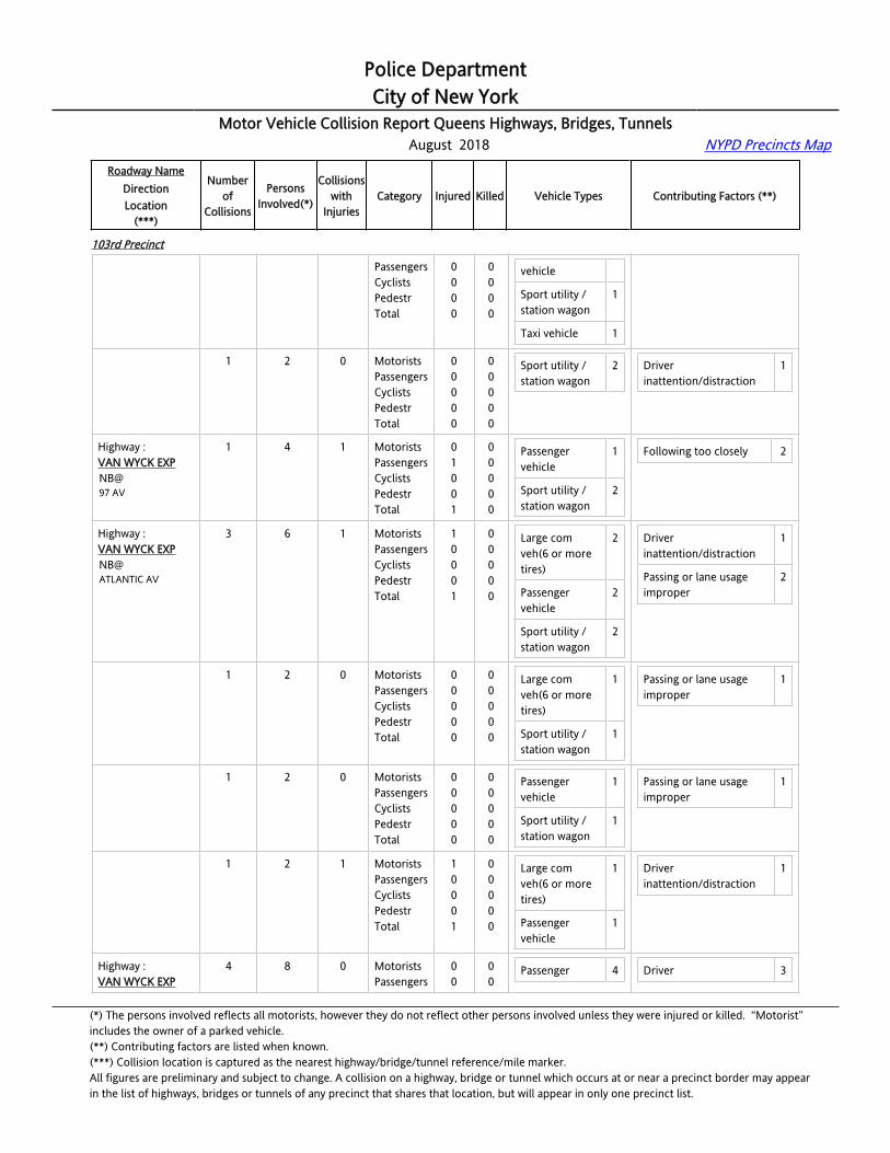
Police Department City of New York Motor Vehicle Collision Report Queens Highways, Bridges, Tunnels August 2018 NYPD Precincts Map Roadway Name Direction Location (***) Number of Collisions Persons Involved(*) Collisions with Injuries Category Injured Killed Vehicle Types Contributing Factors (**) 102nd Precinct Highway : JACKIE ROBINSON PKY EB@ .1 E/O METROPOLITAN 5 10 0 Motorists Passengers Cyclists Pedestr Total 0 0 0 0 0 0 0 0 0 0 Passenger vehicle 7 Sport utility / station wagon 3 Driver inattention/distraction 5 Following too closely 1 Highway : JACKIE ROBINSON PKY EB@ .1 E/O METROPOLITAN 1 2 0 Motorists Passengers Cyclists Pedestr Total 0 0 0 0 0 0 0 0 0 0 Passenger vehicle 2 Following too closely 1 Highway : JACKIE ROBINSON PKY EB@ .1 E/O METROPOLITAN 1 2 0 Motorists Passengers Cyclists Pedestr Total 0 0 0 0 0 0 0 0 0 0 Passenger vehicle 2 Driver inattention/distraction 1 Highway : JACKIE ROBINSON PKY EB@ .1 E/O METROPOLITAN 1 2 0 Motorists Passengers Cyclists Pedestr Total 0 0 0 0 0 0 0 0 0 0 Passenger vehicle 1 Sport utility / station wagon 1 Driver inattention/distraction 2 Highway : JACKIE ROBINSON PKY EB@ .1 E/O METROPOLITAN 1 2 0 Motorists Passengers Cyclists Pedestr Total 0 0 0 0 0 0 0 0 0 0 Passenger vehicle 2 Driver inattention/distraction 1 Highway : JACKIE ROBINSON PKY EB@ .1 E/O METROPOLITAN 1 2 0 Motorists Passengers Cyclists Pedestr Total 0 0 0 0 0 0 0 0 0 0 Sport utility / station wagon 2 Driver inattention/distraction 1 Highway : JACKIE ROBINSON PKY EB@ .1 E/O QUEENS BL 2 4 0 Motorists Passengers Cyclists Pedestr Total 0 0 0 0 0 0 0 0 0 0 Passenger vehicle 3 Sport utility / station wagon 1 Driver inattention/distraction 3 Highway : JACKIE ROBINSON PKY 1 2 0 Motorists Passengers Cyclists 0 0 0 0 0 0 Passenger vehicle 1 Driver inattention/distraction 1 (*) The persons involved reflects all motorists, however they do not reflect other persons involved unless they were injured or killed. “Motorist” includes the owner of a parked vehicle. (**) Contributing factors are listed when known. (***) Collision location is captured as the nearest highway/bridge/tunnel reference/mile marker. All figures are preliminary and subject to change. A collision on a highway, bridge or tunnel which occurs at or near a precinct border may appear in the list of highways, bridges or tunnels of any precinct that shares that location, but will appear in only one precinct list.
Transcript of City of New York Police Department - nyc.gov€¦ · JACKIE ROBINSON PKY WB@ METROPOLITAN AV 1 2 0...

Police DepartmentCity of New York
Motor Vehicle Collision Report Queens Highways, Bridges, Tunnels August 2018 NYPD Precincts Map
Roadway NameDirectionLocation
(***)
Numberof
Collisions
PersonsInvolved(*)
Collisionswith
InjuriesCategory Injured Killed Vehicle Types Contributing Factors (**)
102nd Precinct
Highway :JACKIE ROBINSON [email protected] E/O METROPOLITAN
5 10 0 MotoristsPassengersCyclistsPedestrTotal
00000
00000
Passenger vehicle
7
Sport utility / station wagon
3
Driver inattention/distraction
5
Following too closely 1
Highway :JACKIE ROBINSON [email protected] E/O METROPOLITAN
1 2 0 MotoristsPassengersCyclistsPedestrTotal
00000
00000
Passenger vehicle
2 Following too closely 1
Highway :JACKIE ROBINSON [email protected] E/O METROPOLITAN
1 2 0 MotoristsPassengersCyclistsPedestrTotal
00000
00000
Passenger vehicle
2 Driver inattention/distraction
1
Highway :JACKIE ROBINSON [email protected] E/O METROPOLITAN
1 2 0 MotoristsPassengersCyclistsPedestrTotal
00000
00000
Passenger vehicle
1
Sport utility / station wagon
1
Driver inattention/distraction
2
Highway :JACKIE ROBINSON [email protected] E/O METROPOLITAN
1 2 0 MotoristsPassengersCyclistsPedestrTotal
00000
00000
Passenger vehicle
2 Driver inattention/distraction
1
Highway :JACKIE ROBINSON [email protected] E/O METROPOLITAN
1 2 0 MotoristsPassengersCyclistsPedestrTotal
00000
00000
Sport utility / station wagon
2 Driver inattention/distraction
1
Highway :JACKIE ROBINSON [email protected] E/O QUEENS BL
2 4 0 MotoristsPassengersCyclistsPedestrTotal
00000
00000
Passenger vehicle
3
Sport utility / station wagon
1
Driver inattention/distraction
3
Highway :JACKIE ROBINSON PKY
1 2 0 MotoristsPassengersCyclists
000
000
Passenger vehicle
1 Driver inattention/distraction
1
(*) The persons involved reflects all motorists, however they do not reflect other persons involved unless they were injured or killed. “Motorist” includes the owner of a parked vehicle.(**) Contributing factors are listed when known.(***) Collision location is captured as the nearest highway/bridge/tunnel reference/mile marker.All figures are preliminary and subject to change. A collision on a highway, bridge or tunnel which occurs at or near a precinct border may appearin the list of highways, bridges or tunnels of any precinct that shares that location, but will appear in only one precinct list.

Police DepartmentCity of New York
Motor Vehicle Collision Report Queens Highways, Bridges, Tunnels August 2018 NYPD Precincts Map
Roadway NameDirectionLocation
(***)
Numberof
Collisions
PersonsInvolved(*)
Collisionswith
InjuriesCategory Injured Killed Vehicle Types Contributing Factors (**)
102nd Precinct
[email protected] E/O QUEENS BL
PedestrTotal
00
00
Sport utility / station wagon
1
Highway :JACKIE ROBINSON [email protected] E/O QUEENS BL
1 2 0 MotoristsPassengersCyclistsPedestrTotal
00000
00000
Passenger vehicle
2 Driver inattention/distraction
2
Highway :JACKIE ROBINSON [email protected] W/O METROPOLITAN
1 2 0 MotoristsPassengersCyclistsPedestrTotal
00000
00000
Passenger vehicle
1
Sport utility / station wagon
1
Highway :JACKIE ROBINSON [email protected] E/O WOODHAVEN BL
1 5 1 MotoristsPassengersCyclistsPedestrTotal
02002
00000
Passenger vehicle
1
Sport utility / station wagon
2
Driver inattention/distraction
1
Highway :JACKIE ROBINSON [email protected] W/O METROPOLITAN
2 4 0 MotoristsPassengersCyclistsPedestrTotal
00000
00000
Passenger vehicle
2
Sport utility / station wagon
2
Following too closely 1
Unsafe lane changing 1
Highway :JACKIE ROBINSON [email protected] W/O METROPOLITAN
1 2 0 MotoristsPassengersCyclistsPedestrTotal
00000
00000
Passenger vehicle
1
Sport utility / station wagon
1
Unsafe lane changing 1
Highway :JACKIE ROBINSON [email protected] W/O METROPOLITAN
1 2 0 MotoristsPassengersCyclistsPedestrTotal
00000
00000
Passenger vehicle
1
Sport utility / station wagon
1
Following too closely 1
Highway :JACKIE ROBINSON [email protected] W/O METROPOLITAN
2 4 0 MotoristsPassengersCyclistsPedestrTotal
00000
00000
Passenger vehicle
2
Pick-up truck 1
Sport utility / station wagon
1
Driver inattention/distraction
1
Following too closely 1
Other uninvolved vehicle 1
(*) The persons involved reflects all motorists, however they do not reflect other persons involved unless they were injured or killed. “Motorist” includes the owner of a parked vehicle.(**) Contributing factors are listed when known.(***) Collision location is captured as the nearest highway/bridge/tunnel reference/mile marker.All figures are preliminary and subject to change. A collision on a highway, bridge or tunnel which occurs at or near a precinct border may appearin the list of highways, bridges or tunnels of any precinct that shares that location, but will appear in only one precinct list.

Police DepartmentCity of New York
Motor Vehicle Collision Report Queens Highways, Bridges, Tunnels August 2018 NYPD Precincts Map
Roadway NameDirectionLocation
(***)
Numberof
Collisions
PersonsInvolved(*)
Collisionswith
InjuriesCategory Injured Killed Vehicle Types Contributing Factors (**)
102nd Precinct
Highway :JACKIE ROBINSON [email protected] W/O METROPOLITAN
1 2 0 MotoristsPassengersCyclistsPedestrTotal
00000
00000
Passenger vehicle
1
Sport utility / station wagon
1
Driver inattention/distraction
1
Highway :JACKIE ROBINSON [email protected] W/O METROPOLITAN
1 2 0 MotoristsPassengersCyclistsPedestrTotal
00000
00000
Passenger vehicle
1
Pick-up truck 1
Following too closely 1
Other uninvolved vehicle 1
Highway :JACKIE ROBINSON PKYEB@QUEENS BL
3 6 0 MotoristsPassengersCyclistsPedestrTotal
00000
00000
Passenger vehicle
5
Sport utility / station wagon
1
Driver inattention/distraction
3
Following too closely 1
Highway :JACKIE ROBINSON PKYEB@QUEENS BL
1 2 0 MotoristsPassengersCyclistsPedestrTotal
00000
00000
Passenger vehicle
1
Sport utility / station wagon
1
Driver inattention/distraction
1
Highway :JACKIE ROBINSON PKYEB@QUEENS BL
1 2 0 MotoristsPassengersCyclistsPedestrTotal
00000
00000
Passenger vehicle
2 Following too closely 1
Highway :JACKIE ROBINSON PKYEB@QUEENS BL
1 2 0 MotoristsPassengersCyclistsPedestrTotal
00000
00000
Passenger vehicle
2 Driver inattention/distraction
2
Highway :JACKIE ROBINSON PKYEB@UNION TURNPIKE
1 2 1 MotoristsPassengersCyclistsPedestrTotal
10001
00000
Passenger vehicle
2 Following too closely 1
Highway :JACKIE ROBINSON PKYEB@VAN WYCK EXP
1 2 1 MotoristsPassengersCyclistsPedestrTotal
01001
00000
Sport utility / station wagon
1 Unsafe speed 1
(*) The persons involved reflects all motorists, however they do not reflect other persons involved unless they were injured or killed. “Motorist” includes the owner of a parked vehicle.(**) Contributing factors are listed when known.(***) Collision location is captured as the nearest highway/bridge/tunnel reference/mile marker.All figures are preliminary and subject to change. A collision on a highway, bridge or tunnel which occurs at or near a precinct border may appearin the list of highways, bridges or tunnels of any precinct that shares that location, but will appear in only one precinct list.
Police DepartmentCity of New York
Motor Vehicle Collision Report Queens Highways, Bridges, Tunnels August 2018 NYPD Precincts Map
Roadway NameDirectionLocation
(***)
Numberof
Collisions
PersonsInvolved(*)
Collisionswith
InjuriesCategory Injured Killed Vehicle Types Contributing Factors (**)
102nd Precinct
Highway :JACKIE ROBINSON [email protected] E/O METROPOLITAN
2 4 0 MotoristsPassengersCyclistsPedestrTotal
00000
00000
Passenger vehicle
2
Sport utility / station wagon
2
Driver inexperience 1
Following too closely 1
Highway :JACKIE ROBINSON [email protected] E/O METROPOLITAN
1 2 0 MotoristsPassengersCyclistsPedestrTotal
00000
00000
Passenger vehicle
2 Driver inexperience 1
Highway :JACKIE ROBINSON [email protected] E/O METROPOLITAN
1 2 0 MotoristsPassengersCyclistsPedestrTotal
00000
00000
Sport utility / station wagon
2 Following too closely 1
Highway :JACKIE ROBINSON [email protected] W/O METROPOLITAN
3 6 1 MotoristsPassengersCyclistsPedestrTotal
10001
00000
Passenger vehicle
4
Sport utility / station wagon
2
Driver inattention/distraction
2
Following too closely 1
Highway :JACKIE ROBINSON [email protected] W/O METROPOLITAN
1 2 0 MotoristsPassengersCyclistsPedestrTotal
00000
00000
Passenger vehicle
1
Sport utility / station wagon
1
Following too closely 1
Highway :JACKIE ROBINSON [email protected] W/O METROPOLITAN
1 2 1 MotoristsPassengersCyclistsPedestrTotal
10001
00000
Passenger vehicle
1
Sport utility / station wagon
1
Driver inattention/distraction
1
Highway :JACKIE ROBINSON [email protected] W/O METROPOLITAN
1 2 0 MotoristsPassengersCyclistsPedestrTotal
00000
00000
Passenger vehicle
2 Driver inattention/distraction
1
Highway :JACKIE ROBINSON PKY
1 3 1 MotoristsPassengersCyclists
010
000
Passenger vehicle
1 Driver inattention/distraction
1
(*) The persons involved reflects all motorists, however they do not reflect other persons involved unless they were injured or killed. “Motorist” includes the owner of a parked vehicle.(**) Contributing factors are listed when known.(***) Collision location is captured as the nearest highway/bridge/tunnel reference/mile marker.All figures are preliminary and subject to change. A collision on a highway, bridge or tunnel which occurs at or near a precinct border may appearin the list of highways, bridges or tunnels of any precinct that shares that location, but will appear in only one precinct list.
Police DepartmentCity of New York
Motor Vehicle Collision Report Queens Highways, Bridges, Tunnels August 2018 NYPD Precincts Map
Roadway NameDirectionLocation
(***)
Numberof
Collisions
PersonsInvolved(*)
Collisionswith
InjuriesCategory Injured Killed Vehicle Types Contributing Factors (**)
102nd Precinct
[email protected] W/O METROPOLITAN
PedestrTotal
01
00
Highway :JACKIE ROBINSON [email protected] W/O METROPOLITAN
1 2 0 MotoristsPassengersCyclistsPedestrTotal
00000
00000
Passenger vehicle
1
Sport utility / station wagon
1
Following too closely 1
Highway :JACKIE ROBINSON PKYWB@GRAND CENTRAL PKY
3 6 0 MotoristsPassengersCyclistsPedestrTotal
00000
00000
Passenger vehicle
2
Sport utility / station wagon
3
Taxi vehicle 1
Driver inattention/distraction
3
Following too closely 1
Highway :JACKIE ROBINSON PKYWB@GRAND CENTRAL PKY
1 2 0 MotoristsPassengersCyclistsPedestrTotal
00000
00000
Passenger vehicle
1
Sport utility / station wagon
1
Following too closely 1
Highway :JACKIE ROBINSON PKYWB@GRAND CENTRAL PKY
1 2 0 MotoristsPassengersCyclistsPedestrTotal
00000
00000
Passenger vehicle
1
Taxi vehicle 1
Driver inattention/distraction
1
Highway :JACKIE ROBINSON PKYWB@GRAND CENTRAL PKY
1 2 0 MotoristsPassengersCyclistsPedestrTotal
00000
00000
Sport utility / station wagon
2 Driver inattention/distraction
2
Highway :JACKIE ROBINSON PKYWB@METROPOLITAN AV
1 2 0 MotoristsPassengersCyclistsPedestrTotal
00000
00000
Passenger vehicle
1
Taxi vehicle 1
Following too closely 1
Other uninvolved vehicle 1
Highway :JACKIE ROBINSON PKYWB@UNION TPKE
1 3 1 MotoristsPassengersCyclistsPedestrTotal
01001
00000
Passenger vehicle
1
Sport utility / station wagon
1
Driver inattention/distraction
1
(*) The persons involved reflects all motorists, however they do not reflect other persons involved unless they were injured or killed. “Motorist” includes the owner of a parked vehicle.(**) Contributing factors are listed when known.(***) Collision location is captured as the nearest highway/bridge/tunnel reference/mile marker.All figures are preliminary and subject to change. A collision on a highway, bridge or tunnel which occurs at or near a precinct border may appearin the list of highways, bridges or tunnels of any precinct that shares that location, but will appear in only one precinct list.

Police DepartmentCity of New York
Motor Vehicle Collision Report Queens Highways, Bridges, Tunnels August 2018 NYPD Precincts Map
Roadway NameDirectionLocation
(***)
Numberof
Collisions
PersonsInvolved(*)
Collisionswith
InjuriesCategory Injured Killed Vehicle Types Contributing Factors (**)
102nd Precinct
Highway :VAN WYCK EXPSB@101 AV
2 4 0 MotoristsPassengersCyclistsPedestrTotal
00000
00000
Passenger vehicle
1
Sport utility / station wagon
1
Taxi vehicle 2
Passing or lane usage improper
1
Highway :VAN WYCK EXPSB@101 AV
1 2 0 MotoristsPassengersCyclistsPedestrTotal
00000
00000
Taxi vehicle 2 Passing or lane usage improper
1
Highway :VAN WYCK EXPSB@101 AV
1 2 0 MotoristsPassengersCyclistsPedestrTotal
00000
00000
Passenger vehicle
1
Sport utility / station wagon
1
Highway :VAN WYCK EXPSB@86 AV
1 3 1 MotoristsPassengersCyclistsPedestrTotal
01001
00000
Sport utility / station wagon
2 Driver inattention/distraction
1
Highway :VAN WYCK EXPSB@90 AV
3 6 2 MotoristsPassengersCyclistsPedestrTotal
10012
00000
Passenger vehicle
1
Sport utility / station wagon
3
Driver inattention/distraction
2
Pedest/bike/other pedest error
1
Highway :VAN WYCK EXPSB@90 AV
1 2 1 MotoristsPassengersCyclistsPedestrTotal
10001
00000
Sport utility / station wagon
2 Driver inattention/distraction
1
Highway :VAN WYCK EXPSB@90 AV
1 2 0 MotoristsPassengersCyclistsPedestrTotal
00000
00000
Passenger vehicle
1 Driver inattention/distraction
1
Highway :VAN WYCK EXPSB@90 AV
1 2 1 MotoristsPassengersCyclistsPedestrTotal
00011
00000
Sport utility / station wagon
1 Pedest/bike/other pedest error
1
(*) The persons involved reflects all motorists, however they do not reflect other persons involved unless they were injured or killed. “Motorist” includes the owner of a parked vehicle.(**) Contributing factors are listed when known.(***) Collision location is captured as the nearest highway/bridge/tunnel reference/mile marker.All figures are preliminary and subject to change. A collision on a highway, bridge or tunnel which occurs at or near a precinct border may appearin the list of highways, bridges or tunnels of any precinct that shares that location, but will appear in only one precinct list.

Police DepartmentCity of New York
Motor Vehicle Collision Report Queens Highways, Bridges, Tunnels August 2018 NYPD Precincts Map
Roadway NameDirectionLocation
(***)
Numberof
Collisions
PersonsInvolved(*)
Collisionswith
InjuriesCategory Injured Killed Vehicle Types Contributing Factors (**)
102nd Precinct
Highway :VAN WYCK EXPSB@ATLANTIC AV
3 7 1 MotoristsPassengersCyclistsPedestrTotal
01001
00000
Large com veh(6 or more tires)
1
Passenger vehicle
1
Sport utility / station wagon
3
Driver inattention/distraction
2
Following too closely 2
Highway :VAN WYCK EXPSB@ATLANTIC AV
1 3 1 MotoristsPassengersCyclistsPedestrTotal
01001
00000
Sport utility / station wagon
1 Following too closely 1
Highway :VAN WYCK EXPSB@ATLANTIC AV
1 2 0 MotoristsPassengersCyclistsPedestrTotal
00000
00000
Passenger vehicle
1
Sport utility / station wagon
1
Driver inattention/distraction
1
Following too closely 1
Highway :VAN WYCK EXPSB@ATLANTIC AV
1 2 0 MotoristsPassengersCyclistsPedestrTotal
00000
00000
Large com veh(6 or more tires)
1
Sport utility / station wagon
1
Driver inattention/distraction
1
Highway :VAN WYCK EXPSB@GRAND CENTRAL PKY
1 3 0 MotoristsPassengersCyclistsPedestrTotal
00000
00000
Sport utility / station wagon
3 Driver inattention/distraction
1
Highway :VAN WYCK EXPSB@HILLSIDE AV
7 16 1 MotoristsPassengersCyclistsPedestrTotal
11002
00000
Large com veh(6 or more tires)
1
Passenger vehicle
7
Pick-up truck 1
Sport utility / station wagon
3
Driver inattention/distraction
9
Failure to yield right-of-way
1
Unsafe lane changing 1
Highway :VAN WYCK EXPSB@HILLSIDE AV
1 2 0 MotoristsPassengersCyclistsPedestr
0000
0000
Passenger vehicle
1 Driver inattention/distraction
2
(*) The persons involved reflects all motorists, however they do not reflect other persons involved unless they were injured or killed. “Motorist” includes the owner of a parked vehicle.(**) Contributing factors are listed when known.(***) Collision location is captured as the nearest highway/bridge/tunnel reference/mile marker.All figures are preliminary and subject to change. A collision on a highway, bridge or tunnel which occurs at or near a precinct border may appearin the list of highways, bridges or tunnels of any precinct that shares that location, but will appear in only one precinct list.
Police DepartmentCity of New York
Motor Vehicle Collision Report Queens Highways, Bridges, Tunnels August 2018 NYPD Precincts Map
Roadway NameDirectionLocation
(***)
Numberof
Collisions
PersonsInvolved(*)
Collisionswith
InjuriesCategory Injured Killed Vehicle Types Contributing Factors (**)
102nd Precinct
Total 0 0
Highway :VAN WYCK EXPSB@HILLSIDE AV
1 2 0 MotoristsPassengersCyclistsPedestrTotal
00000
00000
Large com veh(6 or more tires)
1
Passenger vehicle
1
Unsafe lane changing 1
Highway :VAN WYCK EXPSB@HILLSIDE AV
1 2 0 MotoristsPassengersCyclistsPedestrTotal
00000
00000
Passenger vehicle
1
Sport utility / station wagon
1
Failure to yield right-of-way
1
Highway :VAN WYCK EXPSB@HILLSIDE AV
1 2 0 MotoristsPassengersCyclistsPedestrTotal
00000
00000
Passenger vehicle
1
Sport utility / station wagon
1
Driver inattention/distraction
2
Highway :VAN WYCK EXPSB@HILLSIDE AV
1 2 0 MotoristsPassengersCyclistsPedestrTotal
00000
00000
Passenger vehicle
1
Highway :VAN WYCK EXPSB@HILLSIDE AV
1 4 1 MotoristsPassengersCyclistsPedestrTotal
11002
00000
Passenger vehicle
2 Driver inattention/distraction
3
Highway :VAN WYCK EXPSB@HILLSIDE AV
1 2 0 MotoristsPassengersCyclistsPedestrTotal
00000
00000
Pick-up truck 1
Sport utility / station wagon
1
Driver inattention/distraction
2
Highway :VAN WYCK EXPSB@HOOVER AV
1 3 0 MotoristsPassengersCyclistsPedestrTotal
00000
00000
Passenger vehicle
3 Driver inattention/distraction
1
Highway :VAN WYCK EXPSB@JAMAICA AV
6 12 0 MotoristsPassengersCyclistsPedestrTotal
00000
00000
Large com veh(6 or more tires)
2
Passenger 4
Driver inattention/distraction
4
Passing or lane usage improper
1
(*) The persons involved reflects all motorists, however they do not reflect other persons involved unless they were injured or killed. “Motorist” includes the owner of a parked vehicle.(**) Contributing factors are listed when known.(***) Collision location is captured as the nearest highway/bridge/tunnel reference/mile marker.All figures are preliminary and subject to change. A collision on a highway, bridge or tunnel which occurs at or near a precinct border may appearin the list of highways, bridges or tunnels of any precinct that shares that location, but will appear in only one precinct list.

Police DepartmentCity of New York
Motor Vehicle Collision Report Queens Highways, Bridges, Tunnels August 2018 NYPD Precincts Map
Roadway NameDirectionLocation
(***)
Numberof
Collisions
PersonsInvolved(*)
Collisionswith
InjuriesCategory Injured Killed Vehicle Types Contributing Factors (**)
102nd Precinct
vehicle
Sport utility / station wagon
4
Taxi vehicle 1
Unsafe speed 3
Highway :VAN WYCK EXPSB@JAMAICA AV
1 2 0 MotoristsPassengersCyclistsPedestrTotal
00000
00000
Passenger vehicle
1
Sport utility / station wagon
1
Driver inattention/distraction
1
Highway :VAN WYCK EXPSB@JAMAICA AV
1 2 0 MotoristsPassengersCyclistsPedestrTotal
00000
00000
Sport utility / station wagon
1 Driver inattention/distraction
1
Highway :VAN WYCK EXPSB@JAMAICA AV
1 2 0 MotoristsPassengersCyclistsPedestrTotal
00000
00000
Large com veh(6 or more tires)
1
Passenger vehicle
1
Unsafe speed 2
Highway :VAN WYCK EXPSB@JAMAICA AV
1 2 0 MotoristsPassengersCyclistsPedestrTotal
00000
00000
Sport utility / station wagon
2 Driver inattention/distraction
1
Unsafe speed 1
Highway :VAN WYCK EXPSB@JAMAICA AV
1 2 0 MotoristsPassengersCyclistsPedestrTotal
00000
00000
Passenger vehicle
2 Driver inattention/distraction
1
Highway :VAN WYCK EXPSB@JAMAICA AV
1 2 0 MotoristsPassengersCyclistsPedestrTotal
00000
00000
Large com veh(6 or more tires)
1
Taxi vehicle 1
Passing or lane usage improper
1
Highway :VAN WYCK EXPSB@QUEENS BL
9 19 1 MotoristsPassengersCyclistsPedestrTotal
10001
00000
Large com veh(6 or more tires)
1
Passenger vehicle
10
Alcohol involvement 1
Driver inattention/distraction
8
Following too closely 1
(*) The persons involved reflects all motorists, however they do not reflect other persons involved unless they were injured or killed. “Motorist” includes the owner of a parked vehicle.(**) Contributing factors are listed when known.(***) Collision location is captured as the nearest highway/bridge/tunnel reference/mile marker.All figures are preliminary and subject to change. A collision on a highway, bridge or tunnel which occurs at or near a precinct border may appearin the list of highways, bridges or tunnels of any precinct that shares that location, but will appear in only one precinct list.

Police DepartmentCity of New York
Motor Vehicle Collision Report Queens Highways, Bridges, Tunnels August 2018 NYPD Precincts Map
Roadway NameDirectionLocation
(***)
Numberof
Collisions
PersonsInvolved(*)
Collisionswith
InjuriesCategory Injured Killed Vehicle Types Contributing Factors (**)
102nd Precinct
Sport utility / station wagon
6
Taxi vehicle 2
Highway :VAN WYCK EXPSB@QUEENS BL
1 2 0 MotoristsPassengersCyclistsPedestrTotal
00000
00000
Passenger vehicle
2 Driver inattention/distraction
1
Highway :VAN WYCK EXPSB@QUEENS BL
1 2 0 MotoristsPassengersCyclistsPedestrTotal
00000
00000
Sport utility / station wagon
2 Driver inattention/distraction
2
Highway :VAN WYCK EXPSB@QUEENS BL
1 2 0 MotoristsPassengersCyclistsPedestrTotal
00000
00000
Large com veh(6 or more tires)
1
Passenger vehicle
1
Alcohol involvement 1
Highway :VAN WYCK EXPSB@QUEENS BL
1 2 0 MotoristsPassengersCyclistsPedestrTotal
00000
00000
Passenger vehicle
1
Taxi vehicle 1
Driver inattention/distraction
1
Highway :VAN WYCK EXPSB@QUEENS BL
1 3 1 MotoristsPassengersCyclistsPedestrTotal
10001
00000
Passenger vehicle
1
Sport utility / station wagon
2
Driver inattention/distraction
1
Highway :VAN WYCK EXPSB@QUEENS BL
1 2 0 MotoristsPassengersCyclistsPedestrTotal
00000
00000
Passenger vehicle
2 Driver inattention/distraction
1
Highway :VAN WYCK EXPSB@QUEENS BL
1 2 0 MotoristsPassengersCyclistsPedestrTotal
00000
00000
Sport utility / station wagon
1
Taxi vehicle 1
Driver inattention/distraction
1
Highway :VAN WYCK EXP
1 2 0 MotoristsPassengers
00
00
Passenger vehicle
2 Driver inattention/distraction
1
(*) The persons involved reflects all motorists, however they do not reflect other persons involved unless they were injured or killed. “Motorist” includes the owner of a parked vehicle.(**) Contributing factors are listed when known.(***) Collision location is captured as the nearest highway/bridge/tunnel reference/mile marker.All figures are preliminary and subject to change. A collision on a highway, bridge or tunnel which occurs at or near a precinct border may appearin the list of highways, bridges or tunnels of any precinct that shares that location, but will appear in only one precinct list.
Police DepartmentCity of New York
Motor Vehicle Collision Report Queens Highways, Bridges, Tunnels August 2018 NYPD Precincts Map
Roadway NameDirectionLocation
(***)
Numberof
Collisions
PersonsInvolved(*)
Collisionswith
InjuriesCategory Injured Killed Vehicle Types Contributing Factors (**)
102nd Precinct
SB@QUEENS BL
CyclistsPedestrTotal
000
000
Highway :VAN WYCK EXPSB@QUEENS BL
1 2 0 MotoristsPassengersCyclistsPedestrTotal
00000
00000
Passenger vehicle
1
Sport utility / station wagon
1
Following too closely 1
103rd Precinct
Highway :VAN WYCK EXPNB@101 AV
1 3 1 MotoristsPassengersCyclistsPedestrTotal
01001
00000
Sport utility / station wagon
1
Taxi vehicle 1
Driver inattention/distraction
1
Highway :VAN WYCK EXPNB@106 AV
1 2 0 MotoristsPassengersCyclistsPedestrTotal
00000
00000
Sport utility / station wagon
1
Taxi vehicle 1
Driver inattention/distraction
1
Highway :VAN WYCK EXPNB@109 AV
2 4 2 MotoristsPassengersCyclistsPedestrTotal
20002
00000
Sport utility / station wagon
3
Taxi vehicle 1
Driver inattention/distraction
1
Following too closely 1
Highway :VAN WYCK EXPNB@109 AV
1 2 1 MotoristsPassengersCyclistsPedestrTotal
10001
00000
Sport utility / station wagon
2 Driver inattention/distraction
1
Highway :VAN WYCK EXPNB@109 AV
1 2 1 MotoristsPassengersCyclistsPedestrTotal
10001
00000
Sport utility / station wagon
1
Taxi vehicle 1
Following too closely 1
Highway :VAN WYCK EXPNB@91 AV
2 5 0 MotoristsPassengersCyclistsPedestrTotal
00000
00000
Passenger vehicle
1
Sport utility / station wagon
3
Taxi vehicle 1
Driver inattention/distraction
1
Following too closely 1
Highway : 1 3 0 Motorists 0 0 Passenger 1 Following too closely 1
(*) The persons involved reflects all motorists, however they do not reflect other persons involved unless they were injured or killed. “Motorist” includes the owner of a parked vehicle.(**) Contributing factors are listed when known.(***) Collision location is captured as the nearest highway/bridge/tunnel reference/mile marker.All figures are preliminary and subject to change. A collision on a highway, bridge or tunnel which occurs at or near a precinct border may appearin the list of highways, bridges or tunnels of any precinct that shares that location, but will appear in only one precinct list.
Police DepartmentCity of New York
Motor Vehicle Collision Report Queens Highways, Bridges, Tunnels August 2018 NYPD Precincts Map
Roadway NameDirectionLocation
(***)
Numberof
Collisions
PersonsInvolved(*)
Collisionswith
InjuriesCategory Injured Killed Vehicle Types Contributing Factors (**)
103rd Precinct
VAN WYCK EXPNB@91 AV
PassengersCyclistsPedestrTotal
0000
0000
vehicle
Sport utility / station wagon
1
Taxi vehicle 1
Highway :VAN WYCK EXPNB@91 AV
1 2 0 MotoristsPassengersCyclistsPedestrTotal
00000
00000
Sport utility / station wagon
2 Driver inattention/distraction
1
Highway :VAN WYCK EXPNB@97 AV
1 4 1 MotoristsPassengersCyclistsPedestrTotal
01001
00000
Passenger vehicle
1
Sport utility / station wagon
2
Following too closely 2
Highway :VAN WYCK EXPNB@ATLANTIC AV
3 6 1 MotoristsPassengersCyclistsPedestrTotal
10001
00000
Large com veh(6 or more tires)
2
Passenger vehicle
2
Sport utility / station wagon
2
Driver inattention/distraction
1
Passing or lane usage improper
2
Highway :VAN WYCK EXPNB@ATLANTIC AV
1 2 0 MotoristsPassengersCyclistsPedestrTotal
00000
00000
Large com veh(6 or more tires)
1
Sport utility / station wagon
1
Passing or lane usage improper
1
Highway :VAN WYCK EXPNB@ATLANTIC AV
1 2 0 MotoristsPassengersCyclistsPedestrTotal
00000
00000
Passenger vehicle
1
Sport utility / station wagon
1
Passing or lane usage improper
1
Highway :VAN WYCK EXPNB@ATLANTIC AV
1 2 1 MotoristsPassengersCyclistsPedestrTotal
10001
00000
Large com veh(6 or more tires)
1
Passenger vehicle
1
Driver inattention/distraction
1
Highway :VAN WYCK EXP
4 8 0 MotoristsPassengers
00
00
Passenger 4 Driver 3
(*) The persons involved reflects all motorists, however they do not reflect other persons involved unless they were injured or killed. “Motorist” includes the owner of a parked vehicle.(**) Contributing factors are listed when known.(***) Collision location is captured as the nearest highway/bridge/tunnel reference/mile marker.All figures are preliminary and subject to change. A collision on a highway, bridge or tunnel which occurs at or near a precinct border may appearin the list of highways, bridges or tunnels of any precinct that shares that location, but will appear in only one precinct list.

Police DepartmentCity of New York
Motor Vehicle Collision Report Queens Highways, Bridges, Tunnels August 2018 NYPD Precincts Map
Roadway NameDirectionLocation
(***)
Numberof
Collisions
PersonsInvolved(*)
Collisionswith
InjuriesCategory Injured Killed Vehicle Types Contributing Factors (**)
103rd Precinct
NB@JAMAICA AV
CyclistsPedestrTotal
000
000
vehicle
Sport utility / station wagon
4
inattention/distraction
Following too closely 3
Highway :VAN WYCK EXPNB@JAMAICA AV
1 2 0 MotoristsPassengersCyclistsPedestrTotal
00000
00000
Passenger vehicle
1
Sport utility / station wagon
1
Driver inattention/distraction
1
Highway :VAN WYCK EXPNB@JAMAICA AV
1 2 0 MotoristsPassengersCyclistsPedestrTotal
00000
00000
Passenger vehicle
1
Sport utility / station wagon
1
Following too closely 1
Highway :VAN WYCK EXPNB@JAMAICA AV
1 2 0 MotoristsPassengersCyclistsPedestrTotal
00000
00000
Sport utility / station wagon
2 Driver inattention/distraction
2
Highway :VAN WYCK EXPNB@JAMAICA AV
1 2 0 MotoristsPassengersCyclistsPedestrTotal
00000
00000
Passenger vehicle
2 Following too closely 2
Highway :VAN WYCK EXPNB@LIBERTY AV
5 11 1 MotoristsPassengersCyclistsPedestrTotal
11002
00000
Large com veh(6 or more tires)
1
Passenger vehicle
5
Sport utility / station wagon
3
Taxi vehicle 1
Driver inattention/distraction
4
Fell asleep 1
Following too closely 1
Highway :VAN WYCK EXPNB@LIBERTY AV
1 2 0 MotoristsPassengersCyclistsPedestrTotal
00000
00000
Sport utility / station wagon
2 Driver inattention/distraction
2
Highway :VAN WYCK EXPNB@LIBERTY AV
1 3 1 MotoristsPassengersCyclistsPedestr
1100
0000
Large com veh(6 or more tires)
1 Driver inattention/distraction
1
(*) The persons involved reflects all motorists, however they do not reflect other persons involved unless they were injured or killed. “Motorist” includes the owner of a parked vehicle.(**) Contributing factors are listed when known.(***) Collision location is captured as the nearest highway/bridge/tunnel reference/mile marker.All figures are preliminary and subject to change. A collision on a highway, bridge or tunnel which occurs at or near a precinct border may appearin the list of highways, bridges or tunnels of any precinct that shares that location, but will appear in only one precinct list.

Police DepartmentCity of New York
Motor Vehicle Collision Report Queens Highways, Bridges, Tunnels August 2018 NYPD Precincts Map
Roadway NameDirectionLocation
(***)
Numberof
Collisions
PersonsInvolved(*)
Collisionswith
InjuriesCategory Injured Killed Vehicle Types Contributing Factors (**)
103rd Precinct
Total 2 0 Sport utility / station wagon
1
Highway :VAN WYCK EXPNB@LIBERTY AV
1 2 0 MotoristsPassengersCyclistsPedestrTotal
00000
00000
Passenger vehicle
2 Following too closely 1
Highway :VAN WYCK EXPNB@LIBERTY AV
1 2 0 MotoristsPassengersCyclistsPedestrTotal
00000
00000
Passenger vehicle
2 Fell asleep 1
Highway :VAN WYCK EXPNB@LIBERTY AV
1 2 0 MotoristsPassengersCyclistsPedestrTotal
00000
00000
Passenger vehicle
1
Taxi vehicle 1
Driver inattention/distraction
1
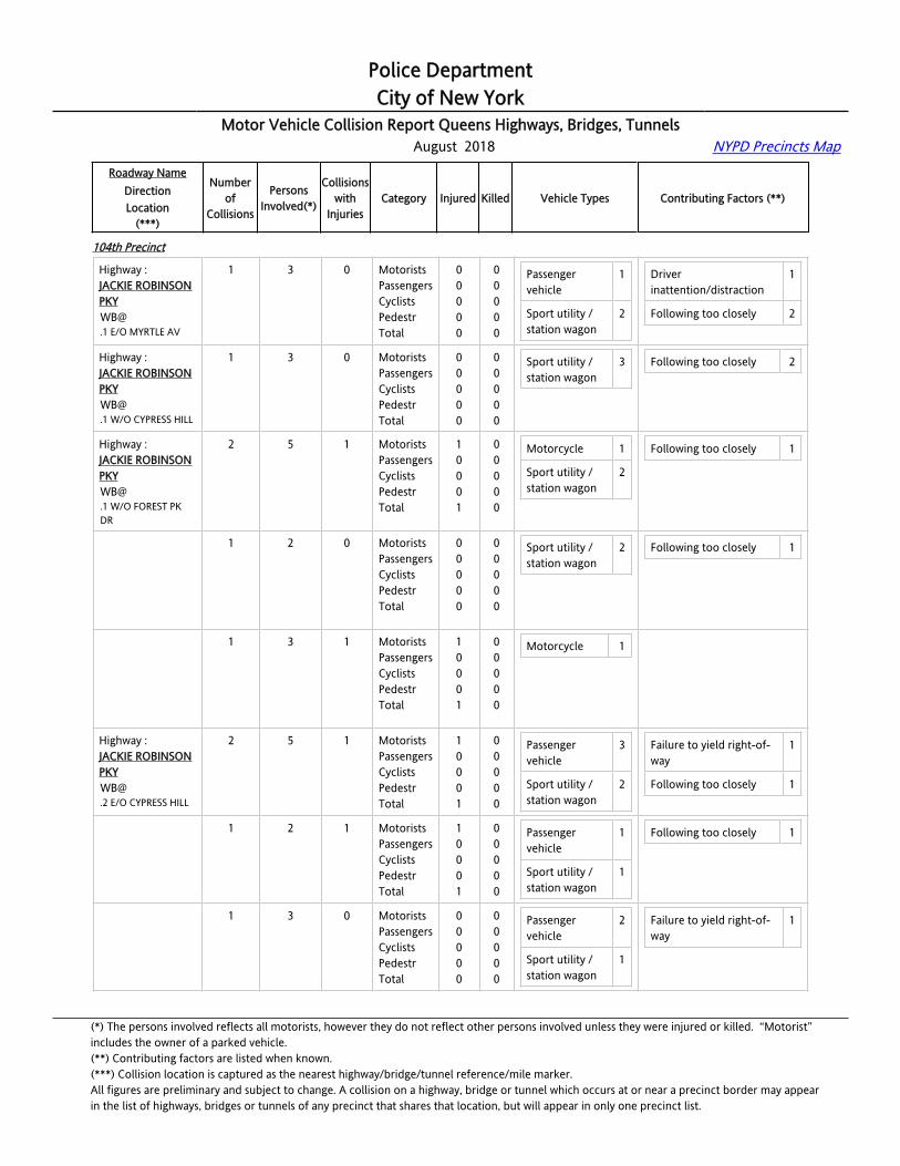
104th Precinct
Highway :JACKIE ROBINSON [email protected] E/O CYPRESS AV
1 2 0 MotoristsPassengersCyclistsPedestrTotal
00000
00000
Passenger vehicle
2 Alcohol involvement 1
Highway :JACKIE ROBINSON [email protected] E/O CYPRESS HILL
1 1 0 MotoristsPassengersCyclistsPedestrTotal
00000
00000
Passenger vehicle
1 Other uninvolved vehicle 1
Highway :JACKIE ROBINSON [email protected] E/O FOREST PK DR
1 2 1 MotoristsPassengersCyclistsPedestrTotal
10001
00000
Sport utility / station wagon
2 Following too closely 1
Highway :JACKIE ROBINSON [email protected] W/O CYPRESS HILL
1 4 0 MotoristsPassengersCyclistsPedestrTotal
00000
00000
Passenger vehicle
2
Sport utility / station wagon
2
Following too closely 1
Other uninvolved vehicle 1
Highway :JACKIE ROBINSON PKY
1 2 0 MotoristsPassengersCyclists
000
000
Pick-up truck 1
Sport utility / 1
Unsafe lane changing 1
(*) The persons involved reflects all motorists, however they do not reflect other persons involved unless they were injured or killed. “Motorist” includes the owner of a parked vehicle.(**) Contributing factors are listed when known.(***) Collision location is captured as the nearest highway/bridge/tunnel reference/mile marker.All figures are preliminary and subject to change. A collision on a highway, bridge or tunnel which occurs at or near a precinct border may appearin the list of highways, bridges or tunnels of any precinct that shares that location, but will appear in only one precinct list.

Police DepartmentCity of New York
Motor Vehicle Collision Report Queens Highways, Bridges, Tunnels August 2018 NYPD Precincts Map
Roadway NameDirectionLocation
(***)
Numberof
Collisions
PersonsInvolved(*)
Collisionswith
InjuriesCategory Injured Killed Vehicle Types Contributing Factors (**)
104th Precinct
[email protected] W/O MYRTLE AV
PedestrTotal
00
00
station wagon
Highway :JACKIE ROBINSON [email protected] W/O MYRTLE AV
1 2 0 MotoristsPassengersCyclistsPedestrTotal
00000
00000
Sport utility / station wagon
2 Following too closely 1
Passing or lane usage improper
1
Highway :JACKIE ROBINSON PKYEB@CEMETERY ROAD
1 1 1 MotoristsPassengersCyclistsPedestrTotal
10001
00000
Passenger vehicle
1
Highway :JACKIE ROBINSON PKYEB@FOREST PARK DR
1 3 1 MotoristsPassengersCyclistsPedestrTotal
01001
00000
Motorcycle 1
Sport utility / station wagon
1
Driver inattention/distraction
1
Highway :JACKIE ROBINSON [email protected] E/O CEMETERY RD
3 10 1 MotoristsPassengersCyclistsPedestrTotal
11002
00000
Passenger vehicle
5
Sport utility / station wagon
4
Following too closely 6
Other uninvolved vehicle 1
Highway :JACKIE ROBINSON [email protected] E/O CEMETERY RD
1 3 1 MotoristsPassengersCyclistsPedestrTotal
11002
00000
Passenger vehicle
2 Following too closely 1
Other uninvolved vehicle 1
Highway :JACKIE ROBINSON [email protected] E/O CEMETERY RD
1 5 0 MotoristsPassengersCyclistsPedestrTotal
00000
00000
Passenger vehicle
2
Sport utility / station wagon
3
Following too closely 4
Highway :JACKIE ROBINSON [email protected] E/O CEMETERY RD
1 2 0 MotoristsPassengersCyclistsPedestrTotal
00000
00000
Passenger vehicle
1
Sport utility / station wagon
1
Following too closely 1
Highway :JACKIE ROBINSON [email protected] E/O CYPRESS HILL
1 2 0 MotoristsPassengersCyclistsPedestrTotal
00000
00000
Passenger vehicle
1
Pick-up truck 1
(*) The persons involved reflects all motorists, however they do not reflect other persons involved unless they were injured or killed. “Motorist” includes the owner of a parked vehicle.(**) Contributing factors are listed when known.(***) Collision location is captured as the nearest highway/bridge/tunnel reference/mile marker.All figures are preliminary and subject to change. A collision on a highway, bridge or tunnel which occurs at or near a precinct border may appearin the list of highways, bridges or tunnels of any precinct that shares that location, but will appear in only one precinct list.
Police DepartmentCity of New York
Motor Vehicle Collision Report Queens Highways, Bridges, Tunnels August 2018 NYPD Precincts Map
Roadway NameDirectionLocation
(***)
Numberof
Collisions
PersonsInvolved(*)
Collisionswith
InjuriesCategory Injured Killed Vehicle Types Contributing Factors (**)
104th Precinct
Highway :JACKIE ROBINSON [email protected] E/O MYRTLE AV
1 3 0 MotoristsPassengersCyclistsPedestrTotal
00000
00000
Passenger vehicle
1
Sport utility / station wagon
2
Driver inattention/distraction
1
Following too closely 2
Highway :JACKIE ROBINSON [email protected] W/O CYPRESS HILL
1 3 0 MotoristsPassengersCyclistsPedestrTotal
00000
00000
Sport utility / station wagon
3 Following too closely 2
Highway :JACKIE ROBINSON [email protected] W/O FOREST PK DR
2 5 1 MotoristsPassengersCyclistsPedestrTotal
10001
00000
Motorcycle 1
Sport utility / station wagon
2
Following too closely 1
Highway :JACKIE ROBINSON [email protected] W/O FOREST PK DR
1 2 0 MotoristsPassengersCyclistsPedestrTotal
00000
00000
Sport utility / station wagon
2 Following too closely 1
Highway :JACKIE ROBINSON [email protected] W/O FOREST PK DR
1 3 1 MotoristsPassengersCyclistsPedestrTotal
10001
00000
Motorcycle 1
Highway :JACKIE ROBINSON [email protected] E/O CYPRESS HILL
2 5 1 MotoristsPassengersCyclistsPedestrTotal
10001
00000
Passenger vehicle
3
Sport utility / station wagon
2
Failure to yield right-of-way
1
Following too closely 1
Highway :JACKIE ROBINSON [email protected] E/O CYPRESS HILL
1 2 1 MotoristsPassengersCyclistsPedestrTotal
10001
00000
Passenger vehicle
1
Sport utility / station wagon
1
Following too closely 1
Highway :JACKIE ROBINSON [email protected] E/O CYPRESS HILL
1 3 0 MotoristsPassengersCyclistsPedestrTotal
00000
00000
Passenger vehicle
2
Sport utility / station wagon
1
Failure to yield right-of-way
1
(*) The persons involved reflects all motorists, however they do not reflect other persons involved unless they were injured or killed. “Motorist” includes the owner of a parked vehicle.(**) Contributing factors are listed when known.(***) Collision location is captured as the nearest highway/bridge/tunnel reference/mile marker.All figures are preliminary and subject to change. A collision on a highway, bridge or tunnel which occurs at or near a precinct border may appearin the list of highways, bridges or tunnels of any precinct that shares that location, but will appear in only one precinct list.
Police DepartmentCity of New York
Motor Vehicle Collision Report Queens Highways, Bridges, Tunnels August 2018 NYPD Precincts Map
Roadway NameDirectionLocation
(***)
Numberof
Collisions
PersonsInvolved(*)
Collisionswith
InjuriesCategory Injured Killed Vehicle Types Contributing Factors (**)
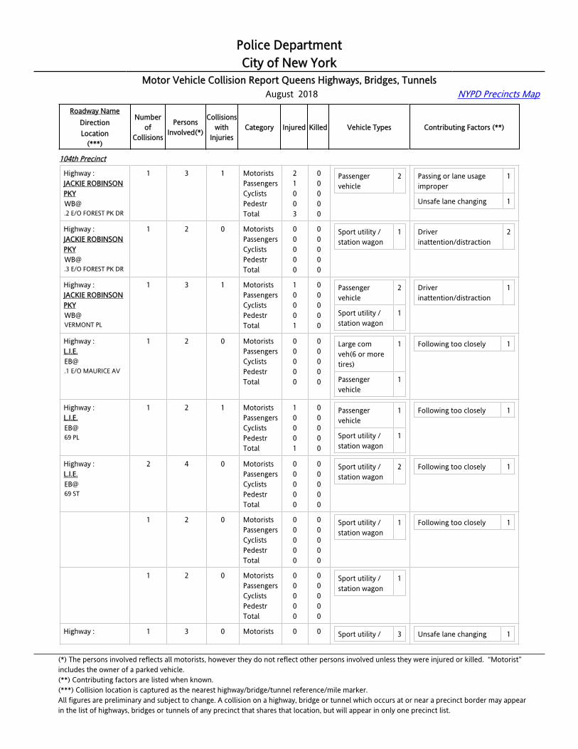
104th Precinct
Highway :JACKIE ROBINSON [email protected] E/O FOREST PK DR
1 3 1 MotoristsPassengersCyclistsPedestrTotal
21003
00000
Passenger vehicle
2 Passing or lane usage improper
1
Unsafe lane changing 1
Highway :JACKIE ROBINSON [email protected] E/O FOREST PK DR
1 2 0 MotoristsPassengersCyclistsPedestrTotal
00000
00000
Sport utility / station wagon
1 Driver inattention/distraction
2
Highway :JACKIE ROBINSON PKYWB@VERMONT PL
1 3 1 MotoristsPassengersCyclistsPedestrTotal
10001
00000
Passenger vehicle
2
Sport utility / station wagon
1
Driver inattention/distraction
1
Highway :[email protected] E/O MAURICE AV
1 2 0 MotoristsPassengersCyclistsPedestrTotal
00000
00000
Large com veh(6 or more tires)
1
Passenger vehicle
1
Following too closely 1
Highway :L.I.E.EB@69 PL
1 2 1 MotoristsPassengersCyclistsPedestrTotal
10001
00000
Passenger vehicle
1
Sport utility / station wagon
1
Following too closely 1
Highway :L.I.E.EB@69 ST
2 4 0 MotoristsPassengersCyclistsPedestrTotal
00000
00000
Sport utility / station wagon
2 Following too closely 1
Highway :L.I.E.EB@69 ST
1 2 0 MotoristsPassengersCyclistsPedestrTotal
00000
00000
Sport utility / station wagon
1 Following too closely 1
Highway :L.I.E.EB@69 ST
1 2 0 MotoristsPassengersCyclistsPedestrTotal
00000
00000
Sport utility / station wagon
1
Highway : 1 3 0 Motorists 0 0 Sport utility / 3 Unsafe lane changing 1
(*) The persons involved reflects all motorists, however they do not reflect other persons involved unless they were injured or killed. “Motorist” includes the owner of a parked vehicle.(**) Contributing factors are listed when known.(***) Collision location is captured as the nearest highway/bridge/tunnel reference/mile marker.All figures are preliminary and subject to change. A collision on a highway, bridge or tunnel which occurs at or near a precinct border may appearin the list of highways, bridges or tunnels of any precinct that shares that location, but will appear in only one precinct list.

Police DepartmentCity of New York
Motor Vehicle Collision Report Queens Highways, Bridges, Tunnels August 2018 NYPD Precincts Map
Roadway NameDirectionLocation
(***)
Numberof
Collisions
PersonsInvolved(*)
Collisionswith
InjuriesCategory Injured Killed Vehicle Types Contributing Factors (**)
104th Precinct
L.I.E.EB@GRAND AV
PassengersCyclistsPedestrTotal
0000
0000
station wagon
Highway :[email protected] E/O MAURICE AV
1 3 0 MotoristsPassengersCyclistsPedestrTotal
00000
00000
Passenger vehicle
2
Taxi vehicle 1
Driver inattention/distraction
1
Highway :[email protected] W/O 65 ST
1 2 1 MotoristsPassengersCyclistsPedestrTotal
10001
00000
Sport utility / station wagon
1
Van 1
Lost consciousness 1
Highway :[email protected] E/O MAURICE AV
1 2 0 MotoristsPassengersCyclistsPedestrTotal
00000
00000
Large com veh(6 or more tires)
1
Sport utility / station wagon
1
Following too closely 1
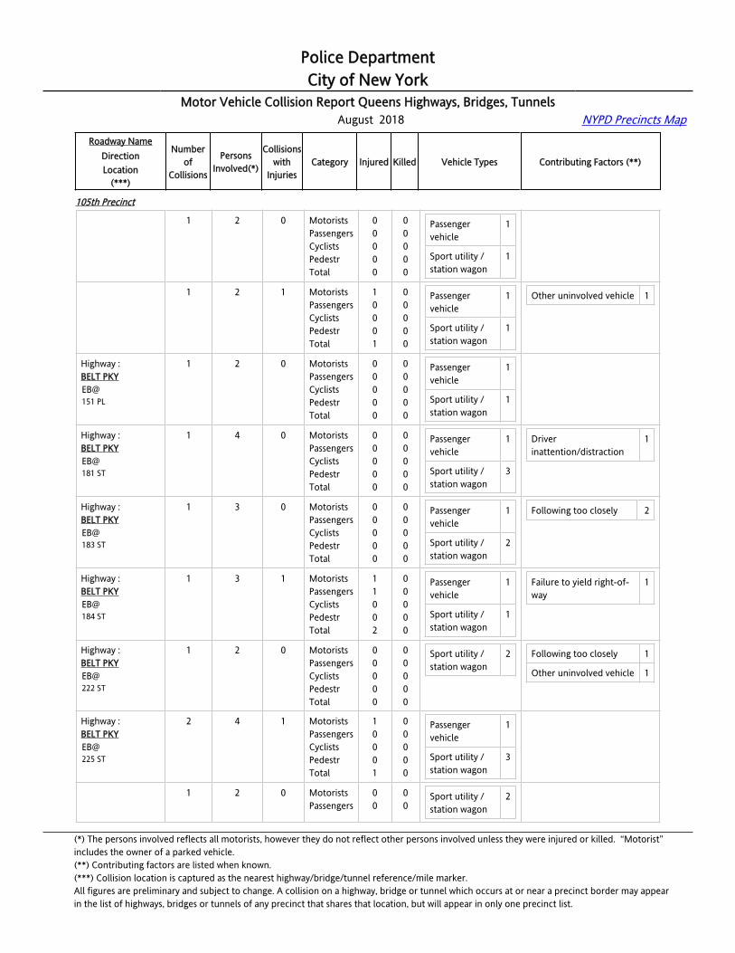
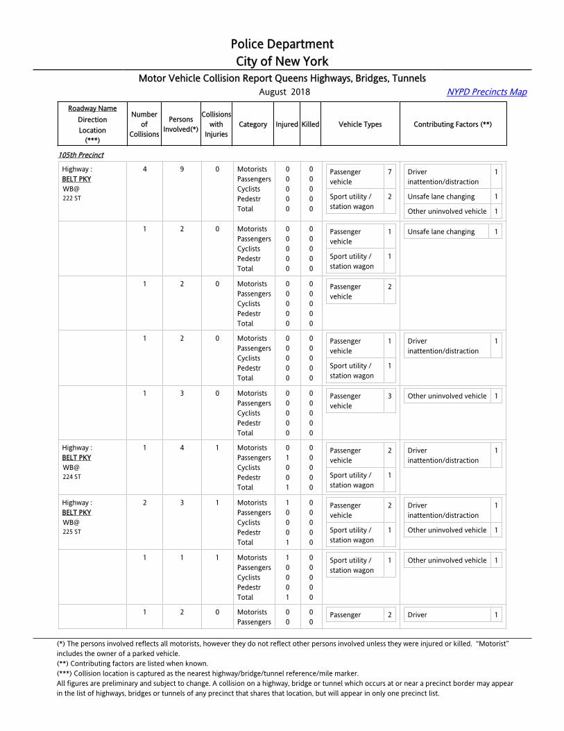
105th Precinct
Highway :BELT [email protected] W/O ROCKAWAY BL
2 4 0 MotoristsPassengersCyclistsPedestrTotal
00000
00000
Passenger vehicle
1
Sport utility / station wagon
3
Driver inattention/distraction
1
Highway :BELT [email protected] W/O ROCKAWAY BL
1 2 0 MotoristsPassengersCyclistsPedestrTotal
00000
00000
Sport utility / station wagon
2
Highway :BELT [email protected] W/O ROCKAWAY BL
1 2 0 MotoristsPassengersCyclistsPedestrTotal
00000
00000
Passenger vehicle
1
Sport utility / station wagon
1
Driver inattention/distraction
1
Highway :BELT PKYEB@150 ST
2 4 1 MotoristsPassengersCyclistsPedestrTotal
10001
00000
Passenger vehicle
2
Sport utility / station wagon
2
Other uninvolved vehicle 1
(*) The persons involved reflects all motorists, however they do not reflect other persons involved unless they were injured or killed. “Motorist” includes the owner of a parked vehicle.(**) Contributing factors are listed when known.(***) Collision location is captured as the nearest highway/bridge/tunnel reference/mile marker.All figures are preliminary and subject to change. A collision on a highway, bridge or tunnel which occurs at or near a precinct border may appearin the list of highways, bridges or tunnels of any precinct that shares that location, but will appear in only one precinct list.
Police DepartmentCity of New York
Motor Vehicle Collision Report Queens Highways, Bridges, Tunnels August 2018 NYPD Precincts Map
Roadway NameDirectionLocation
(***)
Numberof
Collisions
PersonsInvolved(*)
Collisionswith
InjuriesCategory Injured Killed Vehicle Types Contributing Factors (**)
105th Precinct
Highway :BELT PKYEB@150 ST
1 2 0 MotoristsPassengersCyclistsPedestrTotal
00000
00000
Passenger vehicle
1
Sport utility / station wagon
1
Highway :BELT PKYEB@150 ST
1 2 1 MotoristsPassengersCyclistsPedestrTotal
10001
00000
Passenger vehicle
1
Sport utility / station wagon
1
Other uninvolved vehicle 1
Highway :BELT PKYEB@151 PL
1 2 0 MotoristsPassengersCyclistsPedestrTotal
00000
00000
Passenger vehicle
1
Sport utility / station wagon
1
Highway :BELT PKYEB@181 ST
1 4 0 MotoristsPassengersCyclistsPedestrTotal
00000
00000
Passenger vehicle
1
Sport utility / station wagon
3
Driver inattention/distraction
1
Highway :BELT PKYEB@183 ST
1 3 0 MotoristsPassengersCyclistsPedestrTotal
00000
00000
Passenger vehicle
1
Sport utility / station wagon
2
Following too closely 2
Highway :BELT PKYEB@184 ST
1 3 1 MotoristsPassengersCyclistsPedestrTotal
11002
00000
Passenger vehicle
1
Sport utility / station wagon
1
Failure to yield right-of-way
1
Highway :BELT PKYEB@222 ST
1 2 0 MotoristsPassengersCyclistsPedestrTotal
00000
00000
Sport utility / station wagon
2 Following too closely 1
Other uninvolved vehicle 1
Highway :BELT PKYEB@225 ST
2 4 1 MotoristsPassengersCyclistsPedestrTotal
10001
00000
Passenger vehicle
1
Sport utility / station wagon
3
Highway :BELT PKY
1 2 0 MotoristsPassengers
00
00
Sport utility / station wagon
2
(*) The persons involved reflects all motorists, however they do not reflect other persons involved unless they were injured or killed. “Motorist” includes the owner of a parked vehicle.(**) Contributing factors are listed when known.(***) Collision location is captured as the nearest highway/bridge/tunnel reference/mile marker.All figures are preliminary and subject to change. A collision on a highway, bridge or tunnel which occurs at or near a precinct border may appearin the list of highways, bridges or tunnels of any precinct that shares that location, but will appear in only one precinct list.

Police DepartmentCity of New York
Motor Vehicle Collision Report Queens Highways, Bridges, Tunnels August 2018 NYPD Precincts Map
Roadway NameDirectionLocation
(***)
Numberof
Collisions
PersonsInvolved(*)
Collisionswith
InjuriesCategory Injured Killed Vehicle Types Contributing Factors (**)
105th Precinct
EB@225 ST
CyclistsPedestrTotal
000
000
Highway :BELT PKYEB@225 ST
1 2 1 MotoristsPassengersCyclistsPedestrTotal
10001
00000
Passenger vehicle
1
Sport utility / station wagon
1
Highway :BELT PKYEB@232 ST
3 7 3 MotoristsPassengersCyclistsPedestrTotal
40004
00000
Passenger vehicle
4
Sport utility / station wagon
3
Driver inattention/distraction
2
Other uninvolved vehicle 1
Highway :BELT PKYEB@232 ST
1 2 1 MotoristsPassengersCyclistsPedestrTotal
20002
00000
Passenger vehicle
1
Sport utility / station wagon
1
Driver inattention/distraction
1
Highway :BELT PKYEB@232 ST
1 3 1 MotoristsPassengersCyclistsPedestrTotal
10001
00000
Passenger vehicle
1
Sport utility / station wagon
2
Other uninvolved vehicle 1
Highway :BELT PKYEB@232 ST
1 2 1 MotoristsPassengersCyclistsPedestrTotal
10001
00000
Passenger vehicle
2 Driver inattention/distraction
1
Highway :BELT PKYEB@FARMERS BL
5 10 1 MotoristsPassengersCyclistsPedestrTotal
10001
00000
Passenger vehicle
2
Sport utility / station wagon
5
Taxi vehicle 2
Following too closely 2
Passing or lane usage improper
1
Highway :BELT PKYEB@FARMERS BL
1 2 0 MotoristsPassengersCyclistsPedestrTotal
00000
00000
Sport utility / station wagon
2
Highway :BELT PKYEB@
1 2 0 MotoristsPassengersCyclists
000
000
Taxi vehicle 1 Passing or lane usage improper
1
(*) The persons involved reflects all motorists, however they do not reflect other persons involved unless they were injured or killed. “Motorist” includes the owner of a parked vehicle.(**) Contributing factors are listed when known.(***) Collision location is captured as the nearest highway/bridge/tunnel reference/mile marker.All figures are preliminary and subject to change. A collision on a highway, bridge or tunnel which occurs at or near a precinct border may appearin the list of highways, bridges or tunnels of any precinct that shares that location, but will appear in only one precinct list.

Police DepartmentCity of New York
Motor Vehicle Collision Report Queens Highways, Bridges, Tunnels August 2018 NYPD Precincts Map
Roadway NameDirectionLocation
(***)
Numberof
Collisions
PersonsInvolved(*)
Collisionswith
InjuriesCategory Injured Killed Vehicle Types Contributing Factors (**)
105th Precinct
FARMERS BL PedestrTotal
00
00
Highway :BELT PKYEB@FARMERS BL
1 2 0 MotoristsPassengersCyclistsPedestrTotal
00000
00000
Passenger vehicle
1
Sport utility / station wagon
1
Highway :BELT PKYEB@FARMERS BL
1 2 0 MotoristsPassengersCyclistsPedestrTotal
00000
00000
Passenger vehicle
1
Sport utility / station wagon
1
Following too closely 1
Highway :BELT PKYEB@FARMERS BL
1 2 1 MotoristsPassengersCyclistsPedestrTotal
10001
00000
Sport utility / station wagon
1
Taxi vehicle 1
Following too closely 1
Highway :BELT PKYEB@GUY BREWER BL
3 6 0 MotoristsPassengersCyclistsPedestrTotal
00000
00000
Passenger vehicle
2
Sport utility / station wagon
4
Driver inattention/distraction
1
Unsafe speed 1
Highway :BELT PKYEB@GUY BREWER BL
1 2 0 MotoristsPassengersCyclistsPedestrTotal
00000
00000
Passenger vehicle
2 Unsafe speed 1
Highway :BELT PKYEB@GUY BREWER BL
1 2 0 MotoristsPassengersCyclistsPedestrTotal
00000
00000
Sport utility / station wagon
2
Highway :BELT PKYEB@GUY BREWER BL
1 2 0 MotoristsPassengersCyclistsPedestrTotal
00000
00000
Sport utility / station wagon
2 Driver inattention/distraction
1
Highway :BELT PKYEB@LAURELTON PKY
1 2 0 MotoristsPassengersCyclistsPedestrTotal
00000
00000
Passenger vehicle
1
Sport utility / station wagon
1
(*) The persons involved reflects all motorists, however they do not reflect other persons involved unless they were injured or killed. “Motorist” includes the owner of a parked vehicle.(**) Contributing factors are listed when known.(***) Collision location is captured as the nearest highway/bridge/tunnel reference/mile marker.All figures are preliminary and subject to change. A collision on a highway, bridge or tunnel which occurs at or near a precinct border may appearin the list of highways, bridges or tunnels of any precinct that shares that location, but will appear in only one precinct list.

Police DepartmentCity of New York
Motor Vehicle Collision Report Queens Highways, Bridges, Tunnels August 2018 NYPD Precincts Map
Roadway NameDirectionLocation
(***)
Numberof
Collisions
PersonsInvolved(*)
Collisionswith
InjuriesCategory Injured Killed Vehicle Types Contributing Factors (**)
105th Precinct
Highway :BELT PKYEB@ROCKAWAY BL
1 3 1 MotoristsPassengersCyclistsPedestrTotal
10001
00000
Passenger vehicle
3 Unsafe speed 1
Highway :BELT PKYEB@SPRINGFIELD BL
6 13 2 MotoristsPassengersCyclistsPedestrTotal
40004
00000
Passenger vehicle
5
Pick-up truck 1
Sport utility / station wagon
6
Driver inattention/distraction
3
Following too closely 2
Highway :BELT PKYEB@SPRINGFIELD BL
1 2 0 MotoristsPassengersCyclistsPedestrTotal
00000
00000
Passenger vehicle
1
Sport utility / station wagon
1
Driver inattention/distraction
1
Highway :BELT PKYEB@SPRINGFIELD BL
1 2 0 MotoristsPassengersCyclistsPedestrTotal
00000
00000
Sport utility / station wagon
2 Driver inattention/distraction
1
Highway :BELT PKYEB@SPRINGFIELD BL
1 2 1 MotoristsPassengersCyclistsPedestrTotal
20002
00000
Passenger vehicle
1
Sport utility / station wagon
1
Driver inattention/distraction
1
Highway :BELT PKYEB@SPRINGFIELD BL
1 2 0 MotoristsPassengersCyclistsPedestrTotal
00000
00000
Passenger vehicle
1
Highway :BELT PKYEB@SPRINGFIELD BL
1 2 0 MotoristsPassengersCyclistsPedestrTotal
00000
00000
Passenger vehicle
1
Pick-up truck 1
Following too closely 1
Highway :BELT PKYEB@SPRINGFIELD BL
1 3 1 MotoristsPassengersCyclistsPedestrTotal
20002
00000
Passenger vehicle
1
Sport utility / station wagon
2
Following too closely 1
(*) The persons involved reflects all motorists, however they do not reflect other persons involved unless they were injured or killed. “Motorist” includes the owner of a parked vehicle.(**) Contributing factors are listed when known.(***) Collision location is captured as the nearest highway/bridge/tunnel reference/mile marker.All figures are preliminary and subject to change. A collision on a highway, bridge or tunnel which occurs at or near a precinct border may appearin the list of highways, bridges or tunnels of any precinct that shares that location, but will appear in only one precinct list.
Police DepartmentCity of New York
Motor Vehicle Collision Report Queens Highways, Bridges, Tunnels August 2018 NYPD Precincts Map
Roadway NameDirectionLocation
(***)
Numberof
Collisions
PersonsInvolved(*)
Collisionswith
InjuriesCategory Injured Killed Vehicle Types Contributing Factors (**)
105th Precinct
Highway :BELT PKYWB@222 ST
4 9 0 MotoristsPassengersCyclistsPedestrTotal
00000
00000
Passenger vehicle
7
Sport utility / station wagon
2
Driver inattention/distraction
1
Unsafe lane changing 1
Other uninvolved vehicle 1
Highway :BELT PKYWB@222 ST
1 2 0 MotoristsPassengersCyclistsPedestrTotal
00000
00000
Passenger vehicle
1
Sport utility / station wagon
1
Unsafe lane changing 1
Highway :BELT PKYWB@222 ST
1 2 0 MotoristsPassengersCyclistsPedestrTotal
00000
00000
Passenger vehicle
2
Highway :BELT PKYWB@222 ST
1 2 0 MotoristsPassengersCyclistsPedestrTotal
00000
00000
Passenger vehicle
1
Sport utility / station wagon
1
Driver inattention/distraction
1
Highway :BELT PKYWB@222 ST
1 3 0 MotoristsPassengersCyclistsPedestrTotal
00000
00000
Passenger vehicle
3 Other uninvolved vehicle 1
Highway :BELT PKYWB@224 ST
1 4 1 MotoristsPassengersCyclistsPedestrTotal
01001
00000
Passenger vehicle
2
Sport utility / station wagon
1
Driver inattention/distraction
1
Highway :BELT PKYWB@225 ST
2 3 1 MotoristsPassengersCyclistsPedestrTotal
10001
00000
Passenger vehicle
2
Sport utility / station wagon
1
Driver inattention/distraction
1
Other uninvolved vehicle 1
Highway :BELT PKYWB@225 ST
1 1 1 MotoristsPassengersCyclistsPedestrTotal
10001
00000
Sport utility / station wagon
1 Other uninvolved vehicle 1
Highway :BELT PKY
1 2 0 MotoristsPassengers
00
00
Passenger 2 Driver 1
(*) The persons involved reflects all motorists, however they do not reflect other persons involved unless they were injured or killed. “Motorist” includes the owner of a parked vehicle.(**) Contributing factors are listed when known.(***) Collision location is captured as the nearest highway/bridge/tunnel reference/mile marker.All figures are preliminary and subject to change. A collision on a highway, bridge or tunnel which occurs at or near a precinct border may appearin the list of highways, bridges or tunnels of any precinct that shares that location, but will appear in only one precinct list.

Police DepartmentCity of New York
Motor Vehicle Collision Report Queens Highways, Bridges, Tunnels August 2018 NYPD Precincts Map
Roadway NameDirectionLocation
(***)
Numberof
Collisions
PersonsInvolved(*)
Collisionswith
InjuriesCategory Injured Killed Vehicle Types Contributing Factors (**)
105th Precinct
WB@225 ST
CyclistsPedestrTotal
000
000
vehicle inattention/distraction
Highway :BELT PKYWB@231 ST
1 2 0 MotoristsPassengersCyclistsPedestrTotal
00000
00000
Passenger vehicle
2 Following too closely 1
Highway :BELT PKYWB@NORTH CONDUIT
1 2 0 MotoristsPassengersCyclistsPedestrTotal
00000
00000
Passenger vehicle
1
Sport utility / station wagon
1
Following too closely 1
Highway :BELT PKYWB@SPRINGFIELD BL
3 7 0 MotoristsPassengersCyclistsPedestrTotal
00000
00000
Passenger vehicle
3
Sport utility / station wagon
2
Highway :BELT PKYWB@SPRINGFIELD BL
1 3 0 MotoristsPassengersCyclistsPedestrTotal
00000
00000
Passenger vehicle
1
Sport utility / station wagon
1
Highway :BELT PKYWB@SPRINGFIELD BL
1 2 0 MotoristsPassengersCyclistsPedestrTotal
00000
00000
Passenger vehicle
1
Sport utility / station wagon
1
Highway :BELT PKYWB@SPRINGFIELD BL
1 2 0 MotoristsPassengersCyclistsPedestrTotal
00000
00000
Passenger vehicle
1
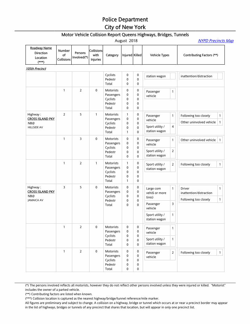
Highway :CROSS ISLAND [email protected] N/O 100 AV
1 2 0 MotoristsPassengersCyclistsPedestrTotal
00000
00000
Passenger vehicle
1
Pick-up truck 1
Highway :CROSS ISLAND [email protected] N/O LINDEN BL
1 2 0 MotoristsPassengersCyclistsPedestr
0000
0000
Passenger vehicle
1
Sport utility / 1
Unsafe lane changing 2
(*) The persons involved reflects all motorists, however they do not reflect other persons involved unless they were injured or killed. “Motorist” includes the owner of a parked vehicle.(**) Contributing factors are listed when known.(***) Collision location is captured as the nearest highway/bridge/tunnel reference/mile marker.All figures are preliminary and subject to change. A collision on a highway, bridge or tunnel which occurs at or near a precinct border may appearin the list of highways, bridges or tunnels of any precinct that shares that location, but will appear in only one precinct list.

Police DepartmentCity of New York
Motor Vehicle Collision Report Queens Highways, Bridges, Tunnels August 2018 NYPD Precincts Map
Roadway NameDirectionLocation
(***)
Numberof
Collisions
PersonsInvolved(*)
Collisionswith
InjuriesCategory Injured Killed Vehicle Types Contributing Factors (**)
105th Precinct
Total 0 0 station wagon
Highway :CROSS ISLAND [email protected] N/O SOUTHERN STAT
2 4 1 MotoristsPassengersCyclistsPedestrTotal
10001
00000
Passenger vehicle
2
Sport utility / station wagon
1
Driver inattention/distraction
1
Passing or lane usage improper
1
Highway :CROSS ISLAND [email protected] N/O SOUTHERN STAT
1 2 0 MotoristsPassengersCyclistsPedestrTotal
00000
00000
Passenger vehicle
1 Passing or lane usage improper
1
Highway :CROSS ISLAND [email protected] N/O SOUTHERN STAT
1 2 1 MotoristsPassengersCyclistsPedestrTotal
10001
00000
Passenger vehicle
1
Sport utility / station wagon
1
Driver inattention/distraction
1
Highway :CROSS ISLAND [email protected] N/O UNION TPKE
1 2 0 MotoristsPassengersCyclistsPedestrTotal
00000
00000
Passenger vehicle
2 Unsafe lane changing 1
Highway :CROSS ISLAND [email protected] S/O LINDEN BL
3 6 1 MotoristsPassengersCyclistsPedestrTotal
10001
00000
Passenger vehicle
4
Sport utility / station wagon
2
Driver inattention/distraction
2
Highway :CROSS ISLAND [email protected] S/O LINDEN BL
1 2 0 MotoristsPassengersCyclistsPedestrTotal
00000
00000
Passenger vehicle
2 Driver inattention/distraction
1
Highway :CROSS ISLAND [email protected] S/O LINDEN BL
1 2 1 MotoristsPassengersCyclistsPedestrTotal
10001
00000
Sport utility / station wagon
2
Highway :CROSS ISLAND [email protected] S/O LINDEN BL
1 2 0 MotoristsPassengersCyclistsPedestrTotal
00000
00000
Passenger vehicle
2 Driver inattention/distraction
1
(*) The persons involved reflects all motorists, however they do not reflect other persons involved unless they were injured or killed. “Motorist” includes the owner of a parked vehicle.(**) Contributing factors are listed when known.(***) Collision location is captured as the nearest highway/bridge/tunnel reference/mile marker.All figures are preliminary and subject to change. A collision on a highway, bridge or tunnel which occurs at or near a precinct border may appearin the list of highways, bridges or tunnels of any precinct that shares that location, but will appear in only one precinct list.

Police DepartmentCity of New York
Motor Vehicle Collision Report Queens Highways, Bridges, Tunnels August 2018 NYPD Precincts Map
Roadway NameDirectionLocation
(***)
Numberof
Collisions
PersonsInvolved(*)
Collisionswith
InjuriesCategory Injured Killed Vehicle Types Contributing Factors (**)
105th Precinct
Highway :CROSS ISLAND PKYNB@115 AV
1 2 0 MotoristsPassengersCyclistsPedestrTotal
00000
00000
Passenger vehicle
1
Sport utility / station wagon
1
Driver inattention/distraction
1
Highway :CROSS ISLAND PKYNB@115 RD
1 2 0 MotoristsPassengersCyclistsPedestrTotal
00000
00000
Passenger vehicle
1
Sport utility / station wagon
1
Highway :CROSS ISLAND PKYNB@116 ST
1 2 0 MotoristsPassengersCyclistsPedestrTotal
00000
00000
Passenger vehicle
1
Sport utility / station wagon
1
Highway :CROSS ISLAND PKYNB@99 AV
1 2 1 MotoristsPassengersCyclistsPedestrTotal
10001
00000
Passenger vehicle
1
Sport utility / station wagon
1
Unsafe lane changing 1
Highway :CROSS ISLAND PKYNB@BRADDOCK AV
1 3 1 MotoristsPassengersCyclistsPedestrTotal
01001
00000
Passenger vehicle
1
Sport utility / station wagon
1
Following too closely 1
Highway :CROSS ISLAND PKYNB@HEMPSTEAD AV
4 8 0 MotoristsPassengersCyclistsPedestrTotal
00000
00000
Passenger vehicle
2
Sport utility / station wagon
5
Driver inattention/distraction
3
Unsafe lane changing 1
Other uninvolved vehicle 1
Highway :CROSS ISLAND PKYNB@HEMPSTEAD AV
1 2 0 MotoristsPassengersCyclistsPedestrTotal
00000
00000
Passenger vehicle
1
Sport utility / station wagon
1
Driver inattention/distraction
1
Unsafe lane changing 1
Highway :CROSS ISLAND PKYNB@HEMPSTEAD AV
1 2 0 MotoristsPassengersCyclistsPedestrTotal
00000
00000
Sport utility / station wagon
2 Driver inattention/distraction
1
Other uninvolved vehicle 1
Highway :CROSS ISLAND PKY
1 2 0 MotoristsPassengers
00
00
Sport utility / 2 Driver 1
(*) The persons involved reflects all motorists, however they do not reflect other persons involved unless they were injured or killed. “Motorist” includes the owner of a parked vehicle.(**) Contributing factors are listed when known.(***) Collision location is captured as the nearest highway/bridge/tunnel reference/mile marker.All figures are preliminary and subject to change. A collision on a highway, bridge or tunnel which occurs at or near a precinct border may appearin the list of highways, bridges or tunnels of any precinct that shares that location, but will appear in only one precinct list.
Police DepartmentCity of New York
Motor Vehicle Collision Report Queens Highways, Bridges, Tunnels August 2018 NYPD Precincts Map
Roadway NameDirectionLocation
(***)
Numberof
Collisions
PersonsInvolved(*)
Collisionswith
InjuriesCategory Injured Killed Vehicle Types Contributing Factors (**)
105th Precinct
NB@HEMPSTEAD AV
CyclistsPedestrTotal
000
000
station wagon inattention/distraction
Highway :CROSS ISLAND PKYNB@HEMPSTEAD AV
1 2 0 MotoristsPassengersCyclistsPedestrTotal
00000
00000
Passenger vehicle
1
Highway :CROSS ISLAND PKYNB@HILLSIDE AV
2 5 1 MotoristsPassengersCyclistsPedestrTotal
10001
00000
Passenger vehicle
1
Sport utility / station wagon
4
Following too closely 1
Other uninvolved vehicle 1
Highway :CROSS ISLAND PKYNB@HILLSIDE AV
1 3 0 MotoristsPassengersCyclistsPedestrTotal
00000
00000
Passenger vehicle
1
Sport utility / station wagon
2
Other uninvolved vehicle 1
Highway :CROSS ISLAND PKYNB@HILLSIDE AV
1 2 1 MotoristsPassengersCyclistsPedestrTotal
10001
00000
Sport utility / station wagon
2 Following too closely 1
Highway :CROSS ISLAND PKYNB@JAMAICA AV
3 5 0 MotoristsPassengersCyclistsPedestrTotal
00000
00000
Large com veh(6 or more tires)
1
Passenger vehicle
3
Sport utility / station wagon
1
Driver inattention/distraction
1
Following too closely 1
Highway :CROSS ISLAND PKYNB@JAMAICA AV
1 2 0 MotoristsPassengersCyclistsPedestrTotal
00000
00000
Passenger vehicle
1
Sport utility / station wagon
1
Highway :CROSS ISLAND PKYNB@JAMAICA AV
1 2 0 MotoristsPassengersCyclistsPedestrTotal
00000
00000
Passenger vehicle
2 Following too closely 1
(*) The persons involved reflects all motorists, however they do not reflect other persons involved unless they were injured or killed. “Motorist” includes the owner of a parked vehicle.(**) Contributing factors are listed when known.(***) Collision location is captured as the nearest highway/bridge/tunnel reference/mile marker.All figures are preliminary and subject to change. A collision on a highway, bridge or tunnel which occurs at or near a precinct border may appearin the list of highways, bridges or tunnels of any precinct that shares that location, but will appear in only one precinct list.

Police DepartmentCity of New York
Motor Vehicle Collision Report Queens Highways, Bridges, Tunnels August 2018 NYPD Precincts Map
Roadway NameDirectionLocation
(***)
Numberof
Collisions
PersonsInvolved(*)
Collisionswith
InjuriesCategory Injured Killed Vehicle Types Contributing Factors (**)
105th Precinct
Highway :CROSS ISLAND PKYNB@JAMAICA AV
1 1 0 MotoristsPassengersCyclistsPedestrTotal
00000
00000
Large com veh(6 or more tires)
1 Driver inattention/distraction
1
Highway :CROSS ISLAND PKYNB@SOUTHERN STATE PKY
1 4 1 MotoristsPassengersCyclistsPedestrTotal
12003
00000
Sport utility / station wagon
2 Other uninvolved vehicle 1
Highway :CROSS ISLAND PKYNB@UNION TPKE
1 2 0 MotoristsPassengersCyclistsPedestrTotal
00000
00000
Passenger vehicle
1
Sport utility / station wagon
1
Following too closely 1
Highway :CROSS ISLAND [email protected] N/O G.C.P.
1 2 0 MotoristsPassengersCyclistsPedestrTotal
00000
00000
Passenger vehicle
2 Following too closely 1
Highway :CROSS ISLAND [email protected] N/O HEMPSTEAD AV
2 4 0 MotoristsPassengersCyclistsPedestrTotal
00000
00000
Passenger vehicle
3 Driver inattention/distraction
1
Highway :CROSS ISLAND [email protected] N/O HEMPSTEAD AV
1 2 0 MotoristsPassengersCyclistsPedestrTotal
00000
00000
Passenger vehicle
1
Highway :CROSS ISLAND [email protected] N/O HEMPSTEAD AV
1 2 0 MotoristsPassengersCyclistsPedestrTotal
00000
00000
Passenger vehicle
2 Driver inattention/distraction
1
Highway :CROSS ISLAND [email protected] N/O LINDEN BL
2 4 1 MotoristsPassengersCyclistsPedestrTotal
10001
00000
Passenger vehicle
4 Alcohol involvement 1
Highway :CROSS ISLAND PKY
1 2 1 MotoristsPassengers
10
00
Passenger vehicle
2 Alcohol involvement 1
(*) The persons involved reflects all motorists, however they do not reflect other persons involved unless they were injured or killed. “Motorist” includes the owner of a parked vehicle.(**) Contributing factors are listed when known.(***) Collision location is captured as the nearest highway/bridge/tunnel reference/mile marker.All figures are preliminary and subject to change. A collision on a highway, bridge or tunnel which occurs at or near a precinct border may appearin the list of highways, bridges or tunnels of any precinct that shares that location, but will appear in only one precinct list.

Police DepartmentCity of New York
Motor Vehicle Collision Report Queens Highways, Bridges, Tunnels August 2018 NYPD Precincts Map
Roadway NameDirectionLocation
(***)
Numberof
Collisions
PersonsInvolved(*)
Collisionswith
InjuriesCategory Injured Killed Vehicle Types Contributing Factors (**)
105th Precinct
[email protected] N/O LINDEN BL
CyclistsPedestrTotal
001
000
Highway :CROSS ISLAND [email protected] N/O LINDEN BL
1 2 0 MotoristsPassengersCyclistsPedestrTotal
00000
00000
Passenger vehicle
2
Highway :CROSS ISLAND [email protected] S/O G.C.P.
1 2 0 MotoristsPassengersCyclistsPedestrTotal
00000
00000
Passenger vehicle
1
Sport utility / station wagon
1
Driver inattention/distraction
1
Highway :CROSS ISLAND PKYSB@105 AV
2 3 1 MotoristsPassengersCyclistsPedestrTotal
10001
00000
Passenger vehicle
3 Driver inattention/distraction
1
Fatigued/drowsy 1
Highway :CROSS ISLAND PKYSB@105 AV
1 2 0 MotoristsPassengersCyclistsPedestrTotal
00000
00000
Passenger vehicle
2 Driver inattention/distraction
1
Highway :CROSS ISLAND PKYSB@105 AV
1 1 1 MotoristsPassengersCyclistsPedestrTotal
10001
00000
Passenger vehicle
1 Fatigued/drowsy 1
Highway :CROSS ISLAND PKYSB@115 AV
1 5 0 MotoristsPassengersCyclistsPedestrTotal
00000
00000
Passenger vehicle
1
Sport utility / station wagon
2
Driver inattention/distraction
1
Highway :CROSS ISLAND PKYSB@82 AV
1 2 1 MotoristsPassengersCyclistsPedestrTotal
10001
00000
Passenger vehicle
2
Highway :CROSS ISLAND PKYSB@86 AV
2 4 1 MotoristsPassengersCyclistsPedestr
1000
0000
Passenger vehicle
2
Sport utility / 2
Following too closely 2
(*) The persons involved reflects all motorists, however they do not reflect other persons involved unless they were injured or killed. “Motorist” includes the owner of a parked vehicle.(**) Contributing factors are listed when known.(***) Collision location is captured as the nearest highway/bridge/tunnel reference/mile marker.All figures are preliminary and subject to change. A collision on a highway, bridge or tunnel which occurs at or near a precinct border may appearin the list of highways, bridges or tunnels of any precinct that shares that location, but will appear in only one precinct list.
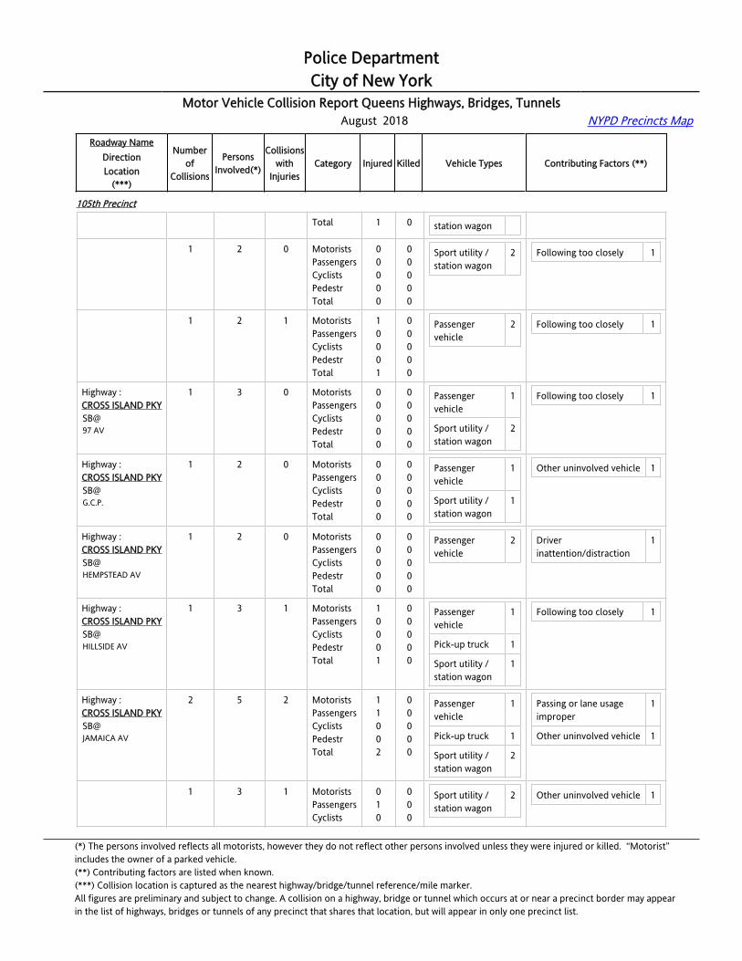
Police DepartmentCity of New York
Motor Vehicle Collision Report Queens Highways, Bridges, Tunnels August 2018 NYPD Precincts Map
Roadway NameDirectionLocation
(***)
Numberof
Collisions
PersonsInvolved(*)
Collisionswith
InjuriesCategory Injured Killed Vehicle Types Contributing Factors (**)
105th Precinct
Total 1 0 station wagon
Highway :CROSS ISLAND PKYSB@86 AV
1 2 0 MotoristsPassengersCyclistsPedestrTotal
00000
00000
Sport utility / station wagon
2 Following too closely 1
Highway :CROSS ISLAND PKYSB@86 AV
1 2 1 MotoristsPassengersCyclistsPedestrTotal
10001
00000
Passenger vehicle
2 Following too closely 1
Highway :CROSS ISLAND PKYSB@97 AV
1 3 0 MotoristsPassengersCyclistsPedestrTotal
00000
00000
Passenger vehicle
1
Sport utility / station wagon
2
Following too closely 1
Highway :CROSS ISLAND [email protected].
1 2 0 MotoristsPassengersCyclistsPedestrTotal
00000
00000
Passenger vehicle
1
Sport utility / station wagon
1
Other uninvolved vehicle 1
Highway :CROSS ISLAND PKYSB@HEMPSTEAD AV
1 2 0 MotoristsPassengersCyclistsPedestrTotal
00000
00000
Passenger vehicle
2 Driver inattention/distraction
1
Highway :CROSS ISLAND PKYSB@HILLSIDE AV
1 3 1 MotoristsPassengersCyclistsPedestrTotal
10001
00000
Passenger vehicle
1
Pick-up truck 1
Sport utility / station wagon
1
Following too closely 1
Highway :CROSS ISLAND PKYSB@JAMAICA AV
2 5 2 MotoristsPassengersCyclistsPedestrTotal
11002
00000
Passenger vehicle
1
Pick-up truck 1
Sport utility / station wagon
2
Passing or lane usage improper
1
Other uninvolved vehicle 1
Highway :CROSS ISLAND PKYSB@
1 3 1 MotoristsPassengersCyclists
010
000
Sport utility / station wagon
2 Other uninvolved vehicle 1
(*) The persons involved reflects all motorists, however they do not reflect other persons involved unless they were injured or killed. “Motorist” includes the owner of a parked vehicle.(**) Contributing factors are listed when known.(***) Collision location is captured as the nearest highway/bridge/tunnel reference/mile marker.All figures are preliminary and subject to change. A collision on a highway, bridge or tunnel which occurs at or near a precinct border may appearin the list of highways, bridges or tunnels of any precinct that shares that location, but will appear in only one precinct list.

Police DepartmentCity of New York
Motor Vehicle Collision Report Queens Highways, Bridges, Tunnels August 2018 NYPD Precincts Map
Roadway NameDirectionLocation
(***)
Numberof
Collisions
PersonsInvolved(*)
Collisionswith
InjuriesCategory Injured Killed Vehicle Types Contributing Factors (**)
105th Precinct
JAMAICA AV PedestrTotal
01
00
Highway :CROSS ISLAND PKYSB@JAMAICA AV
1 2 1 MotoristsPassengersCyclistsPedestrTotal
10001
00000
Passenger vehicle
1
Pick-up truck 1
Passing or lane usage improper
1
Highway :CROSS ISLAND PKYSB@LAURELTON PKY
1 3 0 MotoristsPassengersCyclistsPedestrTotal
00000
00000
Passenger vehicle
2
Sport utility / station wagon
1
Other uninvolved vehicle 3
Highway :CROSS ISLAND PKYSB@SOUTHERN PKY
2 4 1 MotoristsPassengersCyclistsPedestrTotal
10001
00000
Passenger vehicle
4 Following too closely 1
Other uninvolved vehicle 1
Highway :CROSS ISLAND PKYSB@SOUTHERN PKY
1 2 0 MotoristsPassengersCyclistsPedestrTotal
00000
00000
Passenger vehicle
2
Highway :CROSS ISLAND PKYSB@SOUTHERN PKY
1 2 1 MotoristsPassengersCyclistsPedestrTotal
10001
00000
Passenger vehicle
2 Following too closely 1
Other uninvolved vehicle 1
Highway :CROSS ISLAND PKYSB@UNION TPKE
1 2 0 MotoristsPassengersCyclistsPedestrTotal
00000
00000
Passenger vehicle
1
Highway :[email protected] E LITTELNECK PKY
2 8 1 MotoristsPassengersCyclistsPedestrTotal
02002
00000
Passenger vehicle
1
Pick-up truck 1
Sport utility / station wagon
4
Following too closely 2
Highway :[email protected] E LITTELNECK PKY
1 3 0 MotoristsPassengersCyclistsPedestr
0000
0000
Pick-up truck 1
Sport utility / station wagon
2
Following too closely 1
(*) The persons involved reflects all motorists, however they do not reflect other persons involved unless they were injured or killed. “Motorist” includes the owner of a parked vehicle.(**) Contributing factors are listed when known.(***) Collision location is captured as the nearest highway/bridge/tunnel reference/mile marker.All figures are preliminary and subject to change. A collision on a highway, bridge or tunnel which occurs at or near a precinct border may appearin the list of highways, bridges or tunnels of any precinct that shares that location, but will appear in only one precinct list.
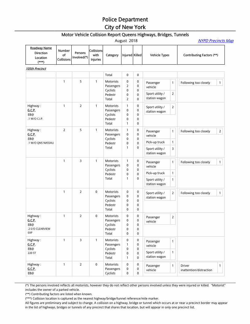
Police DepartmentCity of New York
Motor Vehicle Collision Report Queens Highways, Bridges, Tunnels August 2018 NYPD Precincts Map
Roadway NameDirectionLocation
(***)
Numberof
Collisions
PersonsInvolved(*)
Collisionswith
InjuriesCategory Injured Killed Vehicle Types Contributing Factors (**)
105th Precinct
Total 0 0
Highway :[email protected] E LITTELNECK PKY
1 5 1 MotoristsPassengersCyclistsPedestrTotal
02002
00000
Passenger vehicle
1
Sport utility / station wagon
2
Following too closely 1
Highway :[email protected] W/O C.I.P.
1 2 1 MotoristsPassengersCyclistsPedestrTotal
10001
00000
Sport utility / station wagon
2
Highway :[email protected] W/O QNS NASSAU
2 5 1 MotoristsPassengersCyclistsPedestrTotal
10001
00000
Passenger vehicle
1
Pick-up truck 1
Sport utility / station wagon
3
Following too closely 2
Highway :[email protected] W/O QNS NASSAU
1 3 1 MotoristsPassengersCyclistsPedestrTotal
10001
00000
Passenger vehicle
1
Pick-up truck 1
Sport utility / station wagon
1
Following too closely 1
Highway :[email protected] W/O QNS NASSAU
1 2 0 MotoristsPassengersCyclistsPedestrTotal
00000
00000
Sport utility / station wagon
2 Following too closely 1
Highway :[email protected] E/O CLEARVIEW EXP
1 2 0 MotoristsPassengersCyclistsPedestrTotal
00000
00000
Passenger vehicle
2
Highway :G.C.P.EB@220 ST
1 3 1 MotoristsPassengersCyclistsPedestrTotal
01001
00000
Passenger vehicle
1
Sport utility / station wagon
1
Highway :G.C.P.EB@
1 2 0 MotoristsPassengersCyclists
000
000
Passenger vehicle
1 Driver inattention/distraction
1
(*) The persons involved reflects all motorists, however they do not reflect other persons involved unless they were injured or killed. “Motorist” includes the owner of a parked vehicle.(**) Contributing factors are listed when known.(***) Collision location is captured as the nearest highway/bridge/tunnel reference/mile marker.All figures are preliminary and subject to change. A collision on a highway, bridge or tunnel which occurs at or near a precinct border may appearin the list of highways, bridges or tunnels of any precinct that shares that location, but will appear in only one precinct list.

Police DepartmentCity of New York
Motor Vehicle Collision Report Queens Highways, Bridges, Tunnels August 2018 NYPD Precincts Map
Roadway NameDirectionLocation
(***)
Numberof
Collisions
PersonsInvolved(*)
Collisionswith
InjuriesCategory Injured Killed Vehicle Types Contributing Factors (**)
105th Precinct
CROSS ISLAND PKWY PedestrTotal
00
00
Sport utility / station wagon
1
Highway :G.C.P.EB@LITTLENECK PKY
5 10 0 MotoristsPassengersCyclistsPedestrTotal
00000
00000
Passenger vehicle
4
Sport utility / station wagon
5
Driver inattention/distraction
1
Following too closely 2
Unsafe lane changing 1
Highway :G.C.P.EB@LITTLENECK PKY
1 2 0 MotoristsPassengersCyclistsPedestrTotal
00000
00000
Sport utility / station wagon
1
Highway :G.C.P.EB@LITTLENECK PKY
1 2 0 MotoristsPassengersCyclistsPedestrTotal
00000
00000
Passenger vehicle
1
Sport utility / station wagon
1
Following too closely 1
Highway :G.C.P.EB@LITTLENECK PKY
1 2 0 MotoristsPassengersCyclistsPedestrTotal
00000
00000
Passenger vehicle
1
Sport utility / station wagon
1
Unsafe lane changing 1
Highway :G.C.P.EB@LITTLENECK PKY
1 2 0 MotoristsPassengersCyclistsPedestrTotal
00000
00000
Passenger vehicle
1
Sport utility / station wagon
1
Driver inattention/distraction
1
Highway :G.C.P.EB@LITTLENECK PKY
1 2 0 MotoristsPassengersCyclistsPedestrTotal
00000
00000
Passenger vehicle
1
Sport utility / station wagon
1
Following too closely 1
Highway :G.C.P.EB@WINCHESTER BL
1 2 1 MotoristsPassengersCyclistsPedestrTotal
20002
00000
Passenger vehicle
1
Sport utility / station wagon
1
Driver inattention/distraction
1
Highway :LAURELTON PKYNB@130 AV
1 3 0 MotoristsPassengersCyclistsPedestr
0000
0000
Sport utility / station wagon
3 Passing or lane usage improper
1
(*) The persons involved reflects all motorists, however they do not reflect other persons involved unless they were injured or killed. “Motorist” includes the owner of a parked vehicle.(**) Contributing factors are listed when known.(***) Collision location is captured as the nearest highway/bridge/tunnel reference/mile marker.All figures are preliminary and subject to change. A collision on a highway, bridge or tunnel which occurs at or near a precinct border may appearin the list of highways, bridges or tunnels of any precinct that shares that location, but will appear in only one precinct list.
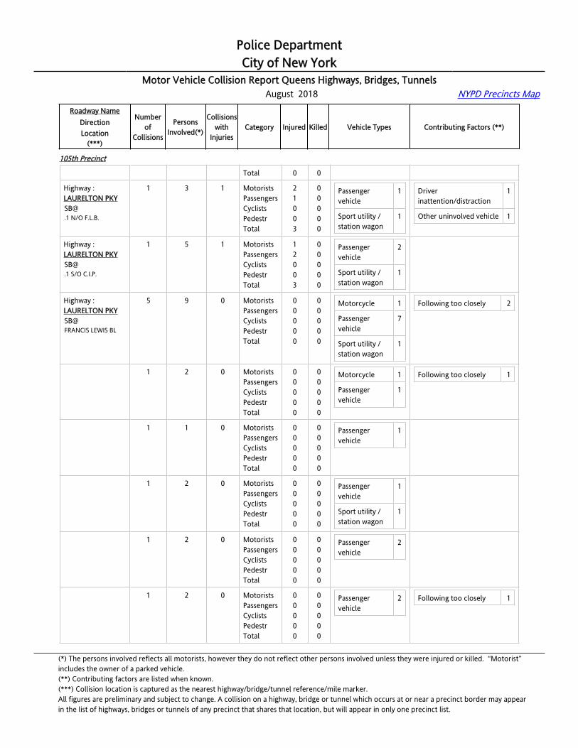
Police DepartmentCity of New York
Motor Vehicle Collision Report Queens Highways, Bridges, Tunnels August 2018 NYPD Precincts Map
Roadway NameDirectionLocation
(***)
Numberof
Collisions
PersonsInvolved(*)
Collisionswith
InjuriesCategory Injured Killed Vehicle Types Contributing Factors (**)
105th Precinct
Total 0 0
Highway :LAURELTON [email protected] N/O F.L.B.
1 3 1 MotoristsPassengersCyclistsPedestrTotal
21003
00000
Passenger vehicle
1
Sport utility / station wagon
1
Driver inattention/distraction
1
Other uninvolved vehicle 1
Highway :LAURELTON [email protected] S/O C.I.P.
1 5 1 MotoristsPassengersCyclistsPedestrTotal
12003
00000
Passenger vehicle
2
Sport utility / station wagon
1
Highway :LAURELTON PKYSB@FRANCIS LEWIS BL
5 9 0 MotoristsPassengersCyclistsPedestrTotal
00000
00000
Motorcycle 1
Passenger vehicle
7
Sport utility / station wagon
1
Following too closely 2
Highway :LAURELTON PKYSB@FRANCIS LEWIS BL
1 2 0 MotoristsPassengersCyclistsPedestrTotal
00000
00000
Motorcycle 1
Passenger vehicle
1
Following too closely 1
Highway :LAURELTON PKYSB@FRANCIS LEWIS BL
1 1 0 MotoristsPassengersCyclistsPedestrTotal
00000
00000
Passenger vehicle
1
Highway :LAURELTON PKYSB@FRANCIS LEWIS BL
1 2 0 MotoristsPassengersCyclistsPedestrTotal
00000
00000
Passenger vehicle
1
Sport utility / station wagon
1
Highway :LAURELTON PKYSB@FRANCIS LEWIS BL
1 2 0 MotoristsPassengersCyclistsPedestrTotal
00000
00000
Passenger vehicle
2
Highway :LAURELTON PKYSB@FRANCIS LEWIS BL
1 2 0 MotoristsPassengersCyclistsPedestrTotal
00000
00000
Passenger vehicle
2 Following too closely 1
(*) The persons involved reflects all motorists, however they do not reflect other persons involved unless they were injured or killed. “Motorist” includes the owner of a parked vehicle.(**) Contributing factors are listed when known.(***) Collision location is captured as the nearest highway/bridge/tunnel reference/mile marker.All figures are preliminary and subject to change. A collision on a highway, bridge or tunnel which occurs at or near a precinct border may appearin the list of highways, bridges or tunnels of any precinct that shares that location, but will appear in only one precinct list.

Police DepartmentCity of New York
Motor Vehicle Collision Report Queens Highways, Bridges, Tunnels August 2018 NYPD Precincts Map
Roadway NameDirectionLocation
(***)
Numberof
Collisions
PersonsInvolved(*)
Collisionswith
InjuriesCategory Injured Killed Vehicle Types Contributing Factors (**)
105th Precinct
Highway :LAURELTON PKYSB@MERRICK BL
2 4 2 MotoristsPassengersCyclistsPedestrTotal
20002
00000
Passenger vehicle
3
Sport utility / station wagon
1
Highway :LAURELTON PKYSB@MERRICK BL
1 2 1 MotoristsPassengersCyclistsPedestrTotal
10001
00000
Passenger vehicle
2
Highway :LAURELTON PKYSB@MERRICK BL
1 2 1 MotoristsPassengersCyclistsPedestrTotal
10001
00000
Passenger vehicle
1
Sport utility / station wagon
1
106th Precinct
Highway :BELT [email protected] E/O CROSSBAY BL
2 4 0 MotoristsPassengersCyclistsPedestrTotal
00000
00000
Passenger vehicle
2
Sport utility / station wagon
2
Failure to yield right-of-way
1
Following too closely 1
Highway :BELT [email protected] E/O CROSSBAY BL
1 2 0 MotoristsPassengersCyclistsPedestrTotal
00000
00000
Passenger vehicle
1
Sport utility / station wagon
1
Failure to yield right-of-way
1
Highway :BELT [email protected] E/O CROSSBAY BL
1 2 0 MotoristsPassengersCyclistsPedestrTotal
00000
00000
Passenger vehicle
1
Sport utility / station wagon
1
Following too closely 1
Highway :BELT PKYEB@126 ST
1 1 1 MotoristsPassengersCyclistsPedestrTotal
10001
00000
Passenger vehicle
1 Other uninvolved vehicle 1
Highway :BELT PKYEB@78 ST
1 2 0 MotoristsPassengersCyclistsPedestrTotal
00000
00000
Passenger vehicle
1
Pick-up truck 1
Unsafe lane changing 1
(*) The persons involved reflects all motorists, however they do not reflect other persons involved unless they were injured or killed. “Motorist” includes the owner of a parked vehicle.(**) Contributing factors are listed when known.(***) Collision location is captured as the nearest highway/bridge/tunnel reference/mile marker.All figures are preliminary and subject to change. A collision on a highway, bridge or tunnel which occurs at or near a precinct border may appearin the list of highways, bridges or tunnels of any precinct that shares that location, but will appear in only one precinct list.
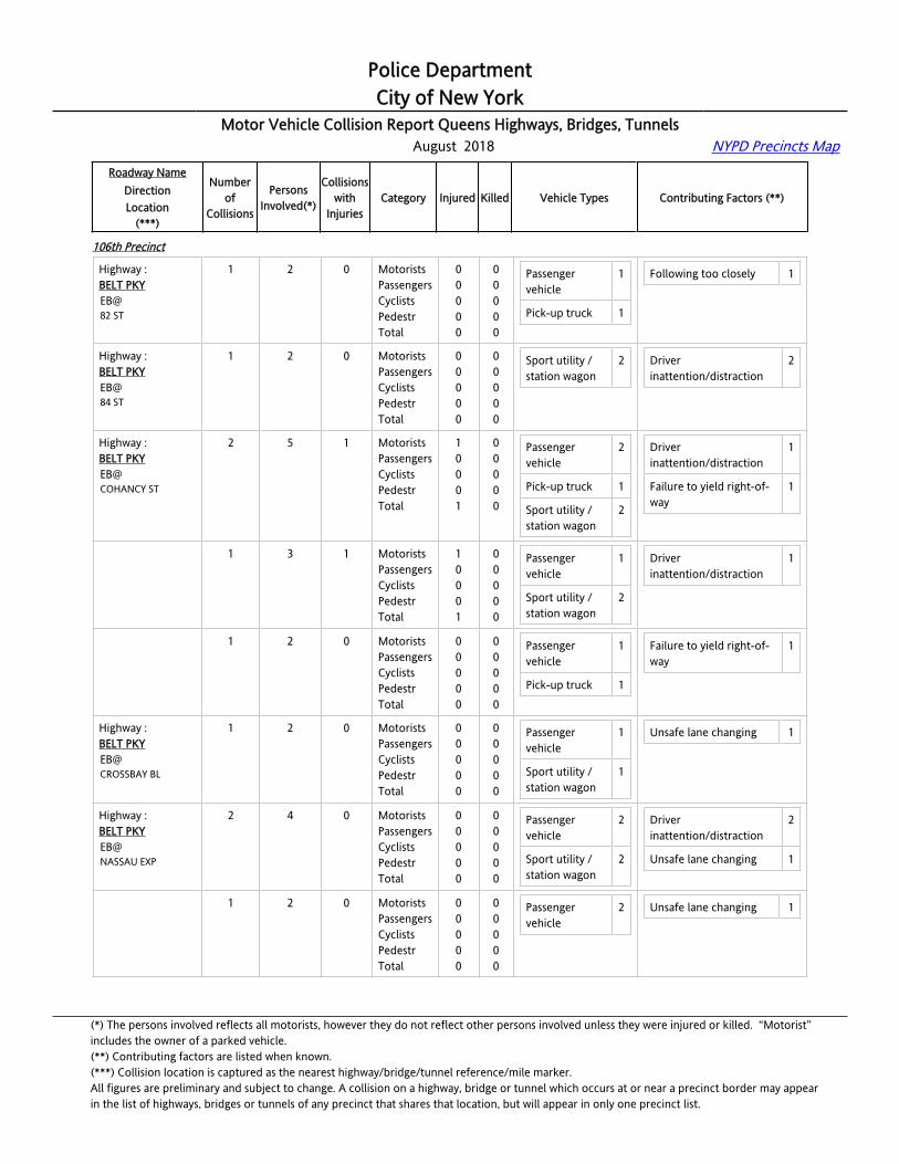
Police DepartmentCity of New York
Motor Vehicle Collision Report Queens Highways, Bridges, Tunnels August 2018 NYPD Precincts Map
Roadway NameDirectionLocation
(***)
Numberof
Collisions
PersonsInvolved(*)
Collisionswith
InjuriesCategory Injured Killed Vehicle Types Contributing Factors (**)
106th Precinct
Highway :BELT PKYEB@82 ST
1 2 0 MotoristsPassengersCyclistsPedestrTotal
00000
00000
Passenger vehicle
1
Pick-up truck 1
Following too closely 1
Highway :BELT PKYEB@84 ST
1 2 0 MotoristsPassengersCyclistsPedestrTotal
00000
00000
Sport utility / station wagon
2 Driver inattention/distraction
2
Highway :BELT PKYEB@COHANCY ST
2 5 1 MotoristsPassengersCyclistsPedestrTotal
10001
00000
Passenger vehicle
2
Pick-up truck 1
Sport utility / station wagon
2
Driver inattention/distraction
1
Failure to yield right-of-way
1
Highway :BELT PKYEB@COHANCY ST
1 3 1 MotoristsPassengersCyclistsPedestrTotal
10001
00000
Passenger vehicle
1
Sport utility / station wagon
2
Driver inattention/distraction
1
Highway :BELT PKYEB@COHANCY ST
1 2 0 MotoristsPassengersCyclistsPedestrTotal
00000
00000
Passenger vehicle
1
Pick-up truck 1
Failure to yield right-of-way
1
Highway :BELT PKYEB@CROSSBAY BL
1 2 0 MotoristsPassengersCyclistsPedestrTotal
00000
00000
Passenger vehicle
1
Sport utility / station wagon
1
Unsafe lane changing 1
Highway :BELT PKYEB@NASSAU EXP
2 4 0 MotoristsPassengersCyclistsPedestrTotal
00000
00000
Passenger vehicle
2
Sport utility / station wagon
2
Driver inattention/distraction
2
Unsafe lane changing 1
Highway :BELT PKYEB@NASSAU EXP
1 2 0 MotoristsPassengersCyclistsPedestrTotal
00000
00000
Passenger vehicle
2 Unsafe lane changing 1
(*) The persons involved reflects all motorists, however they do not reflect other persons involved unless they were injured or killed. “Motorist” includes the owner of a parked vehicle.(**) Contributing factors are listed when known.(***) Collision location is captured as the nearest highway/bridge/tunnel reference/mile marker.All figures are preliminary and subject to change. A collision on a highway, bridge or tunnel which occurs at or near a precinct border may appearin the list of highways, bridges or tunnels of any precinct that shares that location, but will appear in only one precinct list.
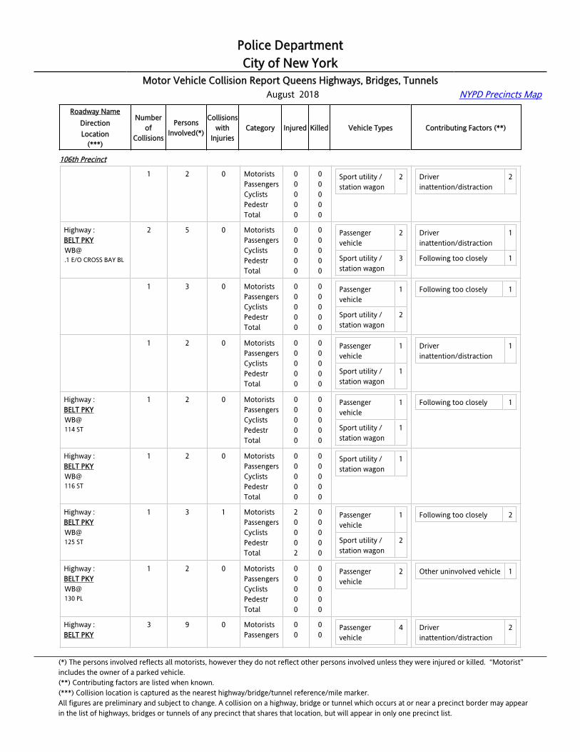
Police DepartmentCity of New York
Motor Vehicle Collision Report Queens Highways, Bridges, Tunnels August 2018 NYPD Precincts Map
Roadway NameDirectionLocation
(***)
Numberof
Collisions
PersonsInvolved(*)
Collisionswith
InjuriesCategory Injured Killed Vehicle Types Contributing Factors (**)
106th Precinct
Highway :BELT PKYEB@NASSAU EXP
1 2 0 MotoristsPassengersCyclistsPedestrTotal
00000
00000
Sport utility / station wagon
2 Driver inattention/distraction
2
Highway :BELT [email protected] E/O CROSS BAY BL
2 5 0 MotoristsPassengersCyclistsPedestrTotal
00000
00000
Passenger vehicle
2
Sport utility / station wagon
3
Driver inattention/distraction
1
Following too closely 1
Highway :BELT [email protected] E/O CROSS BAY BL
1 3 0 MotoristsPassengersCyclistsPedestrTotal
00000
00000
Passenger vehicle
1
Sport utility / station wagon
2
Following too closely 1
Highway :BELT [email protected] E/O CROSS BAY BL
1 2 0 MotoristsPassengersCyclistsPedestrTotal
00000
00000
Passenger vehicle
1
Sport utility / station wagon
1
Driver inattention/distraction
1
Highway :BELT PKYWB@114 ST
1 2 0 MotoristsPassengersCyclistsPedestrTotal
00000
00000
Passenger vehicle
1
Sport utility / station wagon
1
Following too closely 1
Highway :BELT PKYWB@116 ST
1 2 0 MotoristsPassengersCyclistsPedestrTotal
00000
00000
Sport utility / station wagon
1
Highway :BELT PKYWB@125 ST
1 3 1 MotoristsPassengersCyclistsPedestrTotal
20002
00000
Passenger vehicle
1
Sport utility / station wagon
2
Following too closely 2
Highway :BELT PKYWB@130 PL
1 2 0 MotoristsPassengersCyclistsPedestrTotal
00000
00000
Passenger vehicle
2 Other uninvolved vehicle 1
Highway :BELT PKY
3 9 0 MotoristsPassengers
00
00
Passenger vehicle
4 Driver inattention/distraction
2
(*) The persons involved reflects all motorists, however they do not reflect other persons involved unless they were injured or killed. “Motorist” includes the owner of a parked vehicle.(**) Contributing factors are listed when known.(***) Collision location is captured as the nearest highway/bridge/tunnel reference/mile marker.All figures are preliminary and subject to change. A collision on a highway, bridge or tunnel which occurs at or near a precinct border may appearin the list of highways, bridges or tunnels of any precinct that shares that location, but will appear in only one precinct list.

Police DepartmentCity of New York
Motor Vehicle Collision Report Queens Highways, Bridges, Tunnels August 2018 NYPD Precincts Map
Roadway NameDirectionLocation
(***)
Numberof
Collisions
PersonsInvolved(*)
Collisionswith
InjuriesCategory Injured Killed Vehicle Types Contributing Factors (**)
106th Precinct
WB@130 ST
CyclistsPedestrTotal
000
000
Sport utility / station wagon
5 Unsafe lane changing 1
Highway :BELT PKYWB@130 ST
1 2 0 MotoristsPassengersCyclistsPedestrTotal
00000
00000
Sport utility / station wagon
2 Driver inattention/distraction
1
Highway :BELT PKYWB@130 ST
1 4 0 MotoristsPassengersCyclistsPedestrTotal
00000
00000
Passenger vehicle
2
Sport utility / station wagon
2
Driver inattention/distraction
1
Highway :BELT PKYWB@130 ST
1 3 0 MotoristsPassengersCyclistsPedestrTotal
00000
00000
Passenger vehicle
2
Sport utility / station wagon
1
Unsafe lane changing 1
Highway :BELT PKYWB@131 ST
2 4 1 MotoristsPassengersCyclistsPedestrTotal
10001
00000
Passenger vehicle
3
Sport utility / station wagon
1
Driver inattention/distraction
1
Highway :BELT PKYWB@131 ST
1 2 1 MotoristsPassengersCyclistsPedestrTotal
10001
00000
Passenger vehicle
2
Highway :BELT PKYWB@131 ST
1 2 0 MotoristsPassengersCyclistsPedestrTotal
00000
00000
Passenger vehicle
1
Sport utility / station wagon
1
Driver inattention/distraction
1
Highway :BELT PKYWB@134 ST
1 2 0 MotoristsPassengersCyclistsPedestrTotal
00000
00000
Passenger vehicle
1
Sport utility / station wagon
1
Driver inattention/distraction
2
Highway :BELT PKYWB@80 ST
2 7 1 MotoristsPassengersCyclistsPedestr
1100
0000
Passenger vehicle
1
Sport utility / 4
Following too closely 2
(*) The persons involved reflects all motorists, however they do not reflect other persons involved unless they were injured or killed. “Motorist” includes the owner of a parked vehicle.(**) Contributing factors are listed when known.(***) Collision location is captured as the nearest highway/bridge/tunnel reference/mile marker.All figures are preliminary and subject to change. A collision on a highway, bridge or tunnel which occurs at or near a precinct border may appearin the list of highways, bridges or tunnels of any precinct that shares that location, but will appear in only one precinct list.

Police DepartmentCity of New York
Motor Vehicle Collision Report Queens Highways, Bridges, Tunnels August 2018 NYPD Precincts Map
Roadway NameDirectionLocation
(***)
Numberof
Collisions
PersonsInvolved(*)
Collisionswith
InjuriesCategory Injured Killed Vehicle Types Contributing Factors (**)
106th Precinct
Total 2 0 station wagon
Highway :BELT PKYWB@80 ST
1 2 0 MotoristsPassengersCyclistsPedestrTotal
00000
00000
Sport utility / station wagon
2 Following too closely 1
Highway :BELT PKYWB@80 ST
1 5 1 MotoristsPassengersCyclistsPedestrTotal
11002
00000
Passenger vehicle
1
Sport utility / station wagon
2
Following too closely 1
Highway :BELT PKYWB@85 ST
1 3 1 MotoristsPassengersCyclistsPedestrTotal
11002
00000
Passenger vehicle
2 Following too closely 1
Highway :BELT PKYWB@87 ST
1 1 0 MotoristsPassengersCyclistsPedestrTotal
00000
00000
Passenger vehicle
1 Other uninvolved vehicle 1
Highway :BELT PKYWB@91 ST
1 4 1 MotoristsPassengersCyclistsPedestrTotal
11002
00000
Passenger vehicle
3
Highway :BELT PKYWB@COHANCY ST
3 6 0 MotoristsPassengersCyclistsPedestrTotal
00000
00000
Passenger vehicle
2
Sport utility / station wagon
4
Driver inattention/distraction
1
Following too closely 2
Highway :BELT PKYWB@COHANCY ST
1 2 0 MotoristsPassengersCyclistsPedestrTotal
00000
00000
Passenger vehicle
1
Sport utility / station wagon
1
Following too closely 1
Highway :BELT PKYWB@COHANCY ST
1 2 0 MotoristsPassengersCyclistsPedestrTotal
00000
00000
Passenger vehicle
1
Sport utility / station wagon
1
Following too closely 1
(*) The persons involved reflects all motorists, however they do not reflect other persons involved unless they were injured or killed. “Motorist” includes the owner of a parked vehicle.(**) Contributing factors are listed when known.(***) Collision location is captured as the nearest highway/bridge/tunnel reference/mile marker.All figures are preliminary and subject to change. A collision on a highway, bridge or tunnel which occurs at or near a precinct border may appearin the list of highways, bridges or tunnels of any precinct that shares that location, but will appear in only one precinct list.
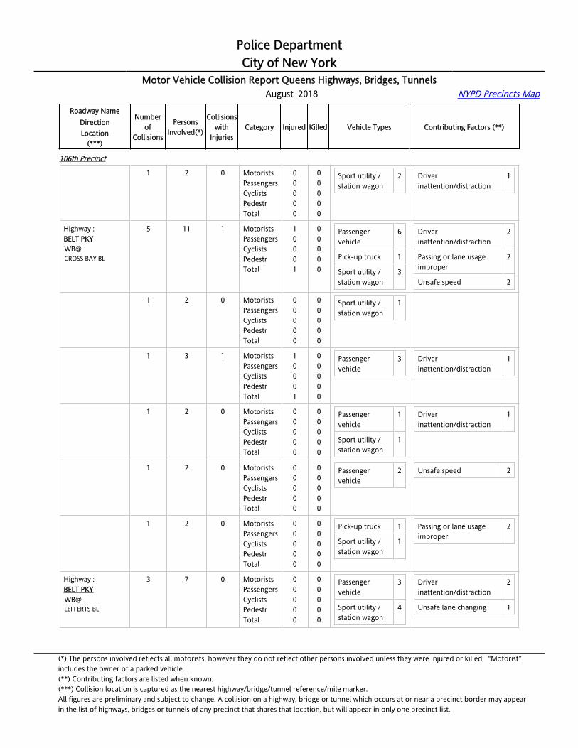
Police DepartmentCity of New York
Motor Vehicle Collision Report Queens Highways, Bridges, Tunnels August 2018 NYPD Precincts Map
Roadway NameDirectionLocation
(***)
Numberof
Collisions
PersonsInvolved(*)
Collisionswith
InjuriesCategory Injured Killed Vehicle Types Contributing Factors (**)
106th Precinct
Highway :BELT PKYWB@COHANCY ST
1 2 0 MotoristsPassengersCyclistsPedestrTotal
00000
00000
Sport utility / station wagon
2 Driver inattention/distraction
1
Highway :BELT PKYWB@CROSS BAY BL
5 11 1 MotoristsPassengersCyclistsPedestrTotal
10001
00000
Passenger vehicle
6
Pick-up truck 1
Sport utility / station wagon
3
Driver inattention/distraction
2
Passing or lane usage improper
2
Unsafe speed 2
Highway :BELT PKYWB@CROSS BAY BL
1 2 0 MotoristsPassengersCyclistsPedestrTotal
00000
00000
Sport utility / station wagon
1
Highway :BELT PKYWB@CROSS BAY BL
1 3 1 MotoristsPassengersCyclistsPedestrTotal
10001
00000
Passenger vehicle
3 Driver inattention/distraction
1
Highway :BELT PKYWB@CROSS BAY BL
1 2 0 MotoristsPassengersCyclistsPedestrTotal
00000
00000
Passenger vehicle
1
Sport utility / station wagon
1
Driver inattention/distraction
1
Highway :BELT PKYWB@CROSS BAY BL
1 2 0 MotoristsPassengersCyclistsPedestrTotal
00000
00000
Passenger vehicle
2 Unsafe speed 2
Highway :BELT PKYWB@CROSS BAY BL
1 2 0 MotoristsPassengersCyclistsPedestrTotal
00000
00000
Pick-up truck 1
Sport utility / station wagon
1
Passing or lane usage improper
2
Highway :BELT PKYWB@LEFFERTS BL
3 7 0 MotoristsPassengersCyclistsPedestrTotal
00000
00000
Passenger vehicle
3
Sport utility / station wagon
4
Driver inattention/distraction
2
Unsafe lane changing 1
(*) The persons involved reflects all motorists, however they do not reflect other persons involved unless they were injured or killed. “Motorist” includes the owner of a parked vehicle.(**) Contributing factors are listed when known.(***) Collision location is captured as the nearest highway/bridge/tunnel reference/mile marker.All figures are preliminary and subject to change. A collision on a highway, bridge or tunnel which occurs at or near a precinct border may appearin the list of highways, bridges or tunnels of any precinct that shares that location, but will appear in only one precinct list.
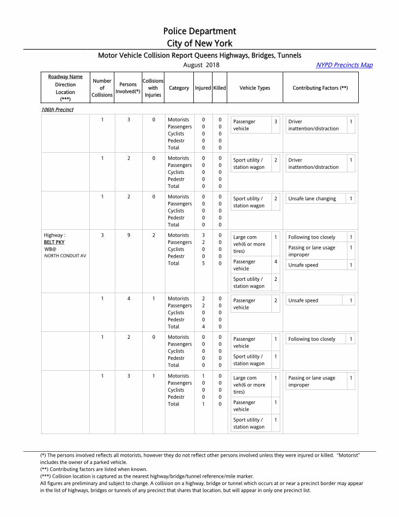
Police DepartmentCity of New York
Motor Vehicle Collision Report Queens Highways, Bridges, Tunnels August 2018 NYPD Precincts Map
Roadway NameDirectionLocation
(***)
Numberof
Collisions
PersonsInvolved(*)
Collisionswith
InjuriesCategory Injured Killed Vehicle Types Contributing Factors (**)
106th Precinct
Highway :BELT PKYWB@LEFFERTS BL
1 3 0 MotoristsPassengersCyclistsPedestrTotal
00000
00000
Passenger vehicle
3 Driver inattention/distraction
1
Highway :BELT PKYWB@LEFFERTS BL
1 2 0 MotoristsPassengersCyclistsPedestrTotal
00000
00000
Sport utility / station wagon
2 Driver inattention/distraction
1
Highway :BELT PKYWB@LEFFERTS BL
1 2 0 MotoristsPassengersCyclistsPedestrTotal
00000
00000
Sport utility / station wagon
2 Unsafe lane changing 1
Highway :BELT PKYWB@NORTH CONDUIT AV
3 9 2 MotoristsPassengersCyclistsPedestrTotal
32005
00000
Large com veh(6 or more tires)
1
Passenger vehicle
4
Sport utility / station wagon
2
Following too closely 1
Passing or lane usage improper
1
Unsafe speed 1
Highway :BELT PKYWB@NORTH CONDUIT AV
1 4 1 MotoristsPassengersCyclistsPedestrTotal
22004
00000
Passenger vehicle
2 Unsafe speed 1
Highway :BELT PKYWB@NORTH CONDUIT AV
1 2 0 MotoristsPassengersCyclistsPedestrTotal
00000
00000
Passenger vehicle
1
Sport utility / station wagon
1
Following too closely 1
Highway :BELT PKYWB@NORTH CONDUIT AV
1 3 1 MotoristsPassengersCyclistsPedestrTotal
10001
00000
Large com veh(6 or more tires)
1
Passenger vehicle
1
Sport utility / station wagon
1
Passing or lane usage improper
1
(*) The persons involved reflects all motorists, however they do not reflect other persons involved unless they were injured or killed. “Motorist” includes the owner of a parked vehicle.(**) Contributing factors are listed when known.(***) Collision location is captured as the nearest highway/bridge/tunnel reference/mile marker.All figures are preliminary and subject to change. A collision on a highway, bridge or tunnel which occurs at or near a precinct border may appearin the list of highways, bridges or tunnels of any precinct that shares that location, but will appear in only one precinct list.

Police DepartmentCity of New York
Motor Vehicle Collision Report Queens Highways, Bridges, Tunnels August 2018 NYPD Precincts Map
Roadway NameDirectionLocation
(***)
Numberof
Collisions
PersonsInvolved(*)
Collisionswith
InjuriesCategory Injured Killed Vehicle Types Contributing Factors (**)
106th Precinct
Highway :NASSAU [email protected] E/O LEFFERTS BL
1 2 0 MotoristsPassengersCyclistsPedestrTotal
00000
00000
Sport utility / station wagon
2 Following too closely 1
Highway :NASSAU EXPEB@125 ST
1 3 1 MotoristsPassengersCyclistsPedestrTotal
11002
00000
Passenger vehicle
1
Taxi vehicle 1
Passing or lane usage improper
1
Highway :VAN WYCK EXPSB@109 AV
3 7 2 MotoristsPassengersCyclistsPedestrTotal
21003
00000
Large com veh(6 or more tires)
2
Passenger vehicle
2
Taxi vehicle 1
Unsafe lane changing 2
Highway :VAN WYCK EXPSB@109 AV
1 2 1 MotoristsPassengersCyclistsPedestrTotal
10001
00000
Large com veh(6 or more tires)
1
Passenger vehicle
1
Highway :VAN WYCK EXPSB@109 AV
1 2 0 MotoristsPassengersCyclistsPedestrTotal
00000
00000
Large com veh(6 or more tires)
1
Passenger vehicle
1
Unsafe lane changing 1
Highway :VAN WYCK EXPSB@109 AV
1 3 1 MotoristsPassengersCyclistsPedestrTotal
11002
00000
Taxi vehicle 1 Unsafe lane changing 1
107th Precinct
Highway :CLEARVIEW [email protected] N/O G.C.P.
1 2 0 MotoristsPassengersCyclistsPedestrTotal
00000
00000
Sport utility / station wagon
1
Taxi vehicle 1
Highway :CLEARVIEW EXP
2 4 1 MotoristsPassengers
20
00
Passenger 1 Driver 2
(*) The persons involved reflects all motorists, however they do not reflect other persons involved unless they were injured or killed. “Motorist” includes the owner of a parked vehicle.(**) Contributing factors are listed when known.(***) Collision location is captured as the nearest highway/bridge/tunnel reference/mile marker.All figures are preliminary and subject to change. A collision on a highway, bridge or tunnel which occurs at or near a precinct border may appearin the list of highways, bridges or tunnels of any precinct that shares that location, but will appear in only one precinct list.
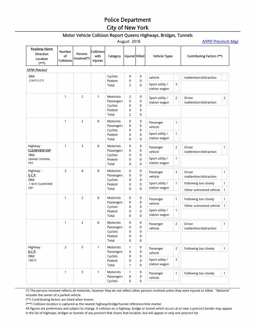
Police DepartmentCity of New York
Motor Vehicle Collision Report Queens Highways, Bridges, Tunnels August 2018 NYPD Precincts Map
Roadway NameDirectionLocation
(***)
Numberof
Collisions
PersonsInvolved(*)
Collisionswith
InjuriesCategory Injured Killed Vehicle Types Contributing Factors (**)
107th Precinct
[email protected] N/O G.C.P.
CyclistsPedestrTotal
002
000
vehicle
Sport utility / station wagon
3
inattention/distraction
Highway :CLEARVIEW [email protected] N/O G.C.P.
1 2 1 MotoristsPassengersCyclistsPedestrTotal
20002
00000
Sport utility / station wagon
2 Driver inattention/distraction
2
Highway :CLEARVIEW [email protected] N/O G.C.P.
1 2 0 MotoristsPassengersCyclistsPedestrTotal
00000
00000
Passenger vehicle
1
Sport utility / station wagon
1
Highway :CLEARVIEW EXPSB@GRAND CENTRAL PKY
1 3 0 MotoristsPassengersCyclistsPedestrTotal
00000
00000
Passenger vehicle
2
Sport utility / station wagon
1
Driver inattention/distraction
1
Highway :[email protected] W/O CLEARVIEW EXP
2 4 0 MotoristsPassengersCyclistsPedestrTotal
00000
00000
Passenger vehicle
3
Sport utility / station wagon
1
Driver inattention/distraction
1
Following too closely 1
Other uninvolved vehicle 1
Highway :[email protected] W/O CLEARVIEW EXP
1 2 0 MotoristsPassengersCyclistsPedestrTotal
00000
00000
Passenger vehicle
1
Sport utility / station wagon
1
Following too closely 1
Other uninvolved vehicle 1
Highway :[email protected] W/O CLEARVIEW EXP
1 2 0 MotoristsPassengersCyclistsPedestrTotal
00000
00000
Passenger vehicle
2 Driver inattention/distraction
1
Highway :G.C.P.EB@168 ST
2 5 1 MotoristsPassengersCyclistsPedestrTotal
10001
00000
Passenger vehicle
2
Sport utility / station wagon
3
Following too closely 1
Highway :G.C.P.EB@
1 3 1 MotoristsPassengersCyclists
100
000
Passenger vehicle
1 Following too closely 1
(*) The persons involved reflects all motorists, however they do not reflect other persons involved unless they were injured or killed. “Motorist” includes the owner of a parked vehicle.(**) Contributing factors are listed when known.(***) Collision location is captured as the nearest highway/bridge/tunnel reference/mile marker.All figures are preliminary and subject to change. A collision on a highway, bridge or tunnel which occurs at or near a precinct border may appearin the list of highways, bridges or tunnels of any precinct that shares that location, but will appear in only one precinct list.

Police DepartmentCity of New York
Motor Vehicle Collision Report Queens Highways, Bridges, Tunnels August 2018 NYPD Precincts Map
Roadway NameDirectionLocation
(***)
Numberof
Collisions
PersonsInvolved(*)
Collisionswith
InjuriesCategory Injured Killed Vehicle Types Contributing Factors (**)
107th Precinct
168 ST PedestrTotal
01
00
Sport utility / station wagon
2
Highway :G.C.P.EB@168 ST
1 2 0 MotoristsPassengersCyclistsPedestrTotal
00000
00000
Passenger vehicle
1
Sport utility / station wagon
1
Highway :G.C.P.EB@170 ST
1 2 1 MotoristsPassengersCyclistsPedestrTotal
10001
00000
Passenger vehicle
2 Following too closely 1
Highway :G.C.P.EB@172 ST
2 4 1 MotoristsPassengersCyclistsPedestrTotal
00000
10001
Motorcycle 1
Pick-up truck 1
Sport utility / station wagon
2
Following too closely 2
Highway :G.C.P.EB@172 ST
1 2 1 MotoristsPassengersCyclistsPedestrTotal
00000
10001
Motorcycle 1
Sport utility / station wagon
1
Following too closely 1
Highway :G.C.P.EB@172 ST
1 2 0 MotoristsPassengersCyclistsPedestrTotal
00000
00000
Pick-up truck 1
Sport utility / station wagon
1
Following too closely 1
Highway :G.C.P.EB@178 ST
1 2 0 MotoristsPassengersCyclistsPedestrTotal
00000
00000
Passenger vehicle
1
Sport utility / station wagon
1
Backing unsafely 1
Highway :G.C.P.EB@188 ST
1 2 0 MotoristsPassengersCyclistsPedestrTotal
00000
00000
Sport utility / station wagon
2 Driver inattention/distraction
1
Highway :G.C.P.EB@193 ST
1 2 1 MotoristsPassengersCyclistsPedestr
1000
0000
Passenger vehicle
1
Sport utility / 1
Following too closely 1
(*) The persons involved reflects all motorists, however they do not reflect other persons involved unless they were injured or killed. “Motorist” includes the owner of a parked vehicle.(**) Contributing factors are listed when known.(***) Collision location is captured as the nearest highway/bridge/tunnel reference/mile marker.All figures are preliminary and subject to change. A collision on a highway, bridge or tunnel which occurs at or near a precinct border may appearin the list of highways, bridges or tunnels of any precinct that shares that location, but will appear in only one precinct list.

Police DepartmentCity of New York
Motor Vehicle Collision Report Queens Highways, Bridges, Tunnels August 2018 NYPD Precincts Map
Roadway NameDirectionLocation
(***)
Numberof
Collisions
PersonsInvolved(*)
Collisionswith
InjuriesCategory Injured Killed Vehicle Types Contributing Factors (**)
107th Precinct
Total 1 0 station wagon
Highway :G.C.P.EB@195 ST
2 3 1 MotoristsPassengersCyclistsPedestrTotal
10001
00000
Motorcycle 1
Passenger vehicle
1
Sport utility / station wagon
1
Highway :G.C.P.EB@195 ST
1 2 0 MotoristsPassengersCyclistsPedestrTotal
00000
00000
Passenger vehicle
1
Sport utility / station wagon
1
Highway :G.C.P.EB@195 ST
1 1 1 MotoristsPassengersCyclistsPedestrTotal
10001
00000
Motorcycle 1
Highway :G.C.P.EB@FRANCIS LEWIS BL
3 6 0 MotoristsPassengersCyclistsPedestrTotal
00000
00000
Passenger vehicle
2
Sport utility / station wagon
4
Driver inattention/distraction
1
Driver inexperience 1
Highway :G.C.P.EB@FRANCIS LEWIS BL
1 2 0 MotoristsPassengersCyclistsPedestrTotal
00000
00000
Sport utility / station wagon
2 Driver inexperience 1
Highway :G.C.P.EB@FRANCIS LEWIS BL
1 2 0 MotoristsPassengersCyclistsPedestrTotal
00000
00000
Passenger vehicle
2
Highway :G.C.P.EB@FRANCIS LEWIS BL
1 2 0 MotoristsPassengersCyclistsPedestrTotal
00000
00000
Sport utility / station wagon
2 Driver inattention/distraction
1
Highway :G.C.P.EB@J ROBINSON PKY EN
1 1 0 MotoristsPassengersCyclistsPedestr
0000
0000
Passenger vehicle
1
(*) The persons involved reflects all motorists, however they do not reflect other persons involved unless they were injured or killed. “Motorist” includes the owner of a parked vehicle.(**) Contributing factors are listed when known.(***) Collision location is captured as the nearest highway/bridge/tunnel reference/mile marker.All figures are preliminary and subject to change. A collision on a highway, bridge or tunnel which occurs at or near a precinct border may appearin the list of highways, bridges or tunnels of any precinct that shares that location, but will appear in only one precinct list.

Police DepartmentCity of New York
Motor Vehicle Collision Report Queens Highways, Bridges, Tunnels August 2018 NYPD Precincts Map
Roadway NameDirectionLocation
(***)
Numberof
Collisions
PersonsInvolved(*)
Collisionswith
InjuriesCategory Injured Killed Vehicle Types Contributing Factors (**)
107th Precinct
Total 0 0
Highway :G.C.P.EB@MAIN ST
1 2 0 MotoristsPassengersCyclistsPedestrTotal
00000
00000
Passenger vehicle
1
Sport utility / station wagon
1
Following too closely 1
Highway :[email protected] E/O F.L.B.
1 4 1 MotoristsPassengersCyclistsPedestrTotal
10001
00000
Passenger vehicle
2
Sport utility / station wagon
1
Highway :G.C.P.WB@164 ST
1 2 1 MotoristsPassengersCyclistsPedestrTotal
10001
00000
Passenger vehicle
1
Sport utility / station wagon
1
Driver inattention/distraction
1
Highway :G.C.P.WB@168 ST
1 5 1 MotoristsPassengersCyclistsPedestrTotal
01001
00000
Passenger vehicle
2
Pick-up truck 1
Sport utility / station wagon
1
Following too closely 1
Highway :G.C.P.WB@188 ST
1 2 0 MotoristsPassengersCyclistsPedestrTotal
00000
00000
Passenger vehicle
1
Sport utility / station wagon
1
Other uninvolved vehicle 2
Highway :G.C.P.WB@199 ST
1 2 0 MotoristsPassengersCyclistsPedestrTotal
00000
00000
Sport utility / station wagon
2 Following too closely 1
Other uninvolved vehicle 1
Highway :G.C.P.WB@FRANCIS LEWIS BL
5 10 2 MotoristsPassengersCyclistsPedestrTotal
20002
00000
Passenger vehicle
6
Sport utility / station wagon
4
Following too closely 2
Unsafe speed 2
Other uninvolved vehicle 1
Highway :G.C.P.WB@FRANCIS LEWIS BL
1 2 0 MotoristsPassengersCyclistsPedestrTotal
00000
00000
Passenger vehicle
1
Sport utility / station wagon
1
(*) The persons involved reflects all motorists, however they do not reflect other persons involved unless they were injured or killed. “Motorist” includes the owner of a parked vehicle.(**) Contributing factors are listed when known.(***) Collision location is captured as the nearest highway/bridge/tunnel reference/mile marker.All figures are preliminary and subject to change. A collision on a highway, bridge or tunnel which occurs at or near a precinct border may appearin the list of highways, bridges or tunnels of any precinct that shares that location, but will appear in only one precinct list.
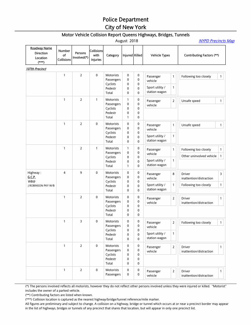
Police DepartmentCity of New York
Motor Vehicle Collision Report Queens Highways, Bridges, Tunnels August 2018 NYPD Precincts Map
Roadway NameDirectionLocation
(***)
Numberof
Collisions
PersonsInvolved(*)
Collisionswith
InjuriesCategory Injured Killed Vehicle Types Contributing Factors (**)
107th Precinct
Highway :G.C.P.WB@FRANCIS LEWIS BL
1 2 0 MotoristsPassengersCyclistsPedestrTotal
00000
00000
Passenger vehicle
1
Sport utility / station wagon
1
Following too closely 1
Highway :G.C.P.WB@FRANCIS LEWIS BL
1 2 1 MotoristsPassengersCyclistsPedestrTotal
10001
00000
Passenger vehicle
2 Unsafe speed 1
Highway :G.C.P.WB@FRANCIS LEWIS BL
1 2 0 MotoristsPassengersCyclistsPedestrTotal
00000
00000
Passenger vehicle
1
Sport utility / station wagon
1
Unsafe speed 1
Highway :G.C.P.WB@FRANCIS LEWIS BL
1 2 1 MotoristsPassengersCyclistsPedestrTotal
10001
00000
Passenger vehicle
1
Sport utility / station wagon
1
Following too closely 1
Other uninvolved vehicle 1
Highway :G.C.P.WB@J ROBINSON PKY W/B
4 9 0 MotoristsPassengersCyclistsPedestrTotal
00000
00000
Passenger vehicle
8
Sport utility / station wagon
1
Driver inattention/distraction
3
Following too closely 1
Highway :G.C.P.WB@J ROBINSON PKY W/B
1 2 0 MotoristsPassengersCyclistsPedestrTotal
00000
00000
Passenger vehicle
2 Driver inattention/distraction
1
Highway :G.C.P.WB@J ROBINSON PKY W/B
1 3 0 MotoristsPassengersCyclistsPedestrTotal
00000
00000
Passenger vehicle
2
Sport utility / station wagon
1
Following too closely 1
Highway :G.C.P.WB@J ROBINSON PKY W/B
1 2 0 MotoristsPassengersCyclistsPedestrTotal
00000
00000
Passenger vehicle
2 Driver inattention/distraction
1
Highway :G.C.P.
1 2 0 MotoristsPassengers
00
00
Passenger vehicle
2 Driver inattention/distraction
1
(*) The persons involved reflects all motorists, however they do not reflect other persons involved unless they were injured or killed. “Motorist” includes the owner of a parked vehicle.(**) Contributing factors are listed when known.(***) Collision location is captured as the nearest highway/bridge/tunnel reference/mile marker.All figures are preliminary and subject to change. A collision on a highway, bridge or tunnel which occurs at or near a precinct border may appearin the list of highways, bridges or tunnels of any precinct that shares that location, but will appear in only one precinct list.

Police DepartmentCity of New York
Motor Vehicle Collision Report Queens Highways, Bridges, Tunnels August 2018 NYPD Precincts Map
Roadway NameDirectionLocation
(***)
Numberof
Collisions
PersonsInvolved(*)
Collisionswith
InjuriesCategory Injured Killed Vehicle Types Contributing Factors (**)
107th Precinct
WB@J ROBINSON PKY W/B
CyclistsPedestrTotal
000
000
Highway :G.C.P.WB@MAIN ST
2 5 0 MotoristsPassengersCyclistsPedestrTotal
00000
00000
Passenger vehicle
3
Sport utility / station wagon
1
Taxi vehicle 1
Driver inattention/distraction
1
Unsafe lane changing 1
Highway :G.C.P.WB@MAIN ST
1 3 0 MotoristsPassengersCyclistsPedestrTotal
00000
00000
Passenger vehicle
2
Sport utility / station wagon
1
Driver inattention/distraction
1
Highway :G.C.P.WB@MAIN ST
1 2 0 MotoristsPassengersCyclistsPedestrTotal
00000
00000
Passenger vehicle
1
Taxi vehicle 1
Unsafe lane changing 1
Highway :G.C.P.WB@MIDLAND PKY
1 1 0 MotoristsPassengersCyclistsPedestrTotal
00000
00000
Sport utility / station wagon
1
Highway :G.C.P.WB@PARSONS BL
2 5 1 MotoristsPassengersCyclistsPedestrTotal
10001
00000
Passenger vehicle
1
Sport utility / station wagon
4
Driver inattention/distraction
3
Following too closely 1
Highway :G.C.P.WB@PARSONS BL
1 3 1 MotoristsPassengersCyclistsPedestrTotal
10001
00000
Sport utility / station wagon
3 Driver inattention/distraction
3
Highway :G.C.P.WB@PARSONS BL
1 2 0 MotoristsPassengersCyclistsPedestrTotal
00000
00000
Passenger vehicle
1
Sport utility / station wagon
1
Following too closely 1
Highway :G.C.P.WB@
1 2 0 MotoristsPassengersCyclists
000
000
Passenger vehicle
1 Following too closely 1
(*) The persons involved reflects all motorists, however they do not reflect other persons involved unless they were injured or killed. “Motorist” includes the owner of a parked vehicle.(**) Contributing factors are listed when known.(***) Collision location is captured as the nearest highway/bridge/tunnel reference/mile marker.All figures are preliminary and subject to change. A collision on a highway, bridge or tunnel which occurs at or near a precinct border may appearin the list of highways, bridges or tunnels of any precinct that shares that location, but will appear in only one precinct list.

Police DepartmentCity of New York
Motor Vehicle Collision Report Queens Highways, Bridges, Tunnels August 2018 NYPD Precincts Map
Roadway NameDirectionLocation
(***)
Numberof
Collisions
PersonsInvolved(*)
Collisionswith
InjuriesCategory Injured Killed Vehicle Types Contributing Factors (**)
107th Precinct
VAN WYCK EXP S/B PedestrTotal
00
00
Sport utility / station wagon
1
Highway :[email protected] E/O MAIN ST
2 4 0 MotoristsPassengersCyclistsPedestrTotal
00000
00000
Passenger vehicle
3
Sport utility / station wagon
1
Driver inattention/distraction
2
Highway :[email protected] E/O MAIN ST
1 2 0 MotoristsPassengersCyclistsPedestrTotal
00000
00000
Passenger vehicle
1
Sport utility / station wagon
1
Driver inattention/distraction
1
Highway :[email protected] E/O MAIN ST
1 2 0 MotoristsPassengersCyclistsPedestrTotal
00000
00000
Passenger vehicle
2 Driver inattention/distraction
1
Highway :L.I.E.EB@156 ST
1 2 1 MotoristsPassengersCyclistsPedestrTotal
10001
00000
Passenger vehicle
2 Driver inattention/distraction
1
Highway :L.I.E.EB@163 ST
1 3 0 MotoristsPassengersCyclistsPedestrTotal
00000
00000
Sport utility / station wagon
3 Driver inattention/distraction
1
Highway :L.I.E.EB@169 ST
1 2 0 MotoristsPassengersCyclistsPedestrTotal
00000
00000
Passenger vehicle
1
Taxi vehicle 1
Following too closely 1
Highway :L.I.E.EB@185 ST
1 2 0 MotoristsPassengersCyclistsPedestrTotal
00000
00000
Pick-up truck 1
Van 1
Following too closely 1
Highway :L.I.E.EB@194 ST
1 2 0 MotoristsPassengersCyclistsPedestrTotal
00000
00000
Sport utility / station wagon
2
(*) The persons involved reflects all motorists, however they do not reflect other persons involved unless they were injured or killed. “Motorist” includes the owner of a parked vehicle.(**) Contributing factors are listed when known.(***) Collision location is captured as the nearest highway/bridge/tunnel reference/mile marker.All figures are preliminary and subject to change. A collision on a highway, bridge or tunnel which occurs at or near a precinct border may appearin the list of highways, bridges or tunnels of any precinct that shares that location, but will appear in only one precinct list.

Police DepartmentCity of New York
Motor Vehicle Collision Report Queens Highways, Bridges, Tunnels August 2018 NYPD Precincts Map
Roadway NameDirectionLocation
(***)
Numberof
Collisions
PersonsInvolved(*)
Collisionswith
InjuriesCategory Injured Killed Vehicle Types Contributing Factors (**)
107th Precinct
Highway :L.I.E.EB@201 ST
1 3 1 MotoristsPassengersCyclistsPedestrTotal
11002
00000
Pick-up truck 1
Sport utility / station wagon
1
Following too closely 1
Highway :L.I.E.EB@205 ST
2 4 0 MotoristsPassengersCyclistsPedestrTotal
00000
00000
Sport utility / station wagon
1
Taxi vehicle 1
Following too closely 1
Unsafe lane changing 1
Highway :L.I.E.EB@205 ST
1 2 0 MotoristsPassengersCyclistsPedestrTotal
00000
00000
Sport utility / station wagon
1 Following too closely 1
Highway :L.I.E.EB@205 ST
1 2 0 MotoristsPassengersCyclistsPedestrTotal
00000
00000
Taxi vehicle 1 Unsafe lane changing 1
Highway :L.I.E.EB@CLEARVIEW EXP
4 8 2 MotoristsPassengersCyclistsPedestrTotal
20002
00000
Passenger vehicle
3
Pick-up truck 3
Sport utility / station wagon
2
Following too closely 2
Unsafe lane changing 1
Highway :L.I.E.EB@CLEARVIEW EXP
1 2 1 MotoristsPassengersCyclistsPedestrTotal
10001
00000
Passenger vehicle
1
Sport utility / station wagon
1
Following too closely 1
Highway :L.I.E.EB@CLEARVIEW EXP
1 2 0 MotoristsPassengersCyclistsPedestrTotal
00000
00000
Passenger vehicle
1
Pick-up truck 1
Unsafe lane changing 1
Highway :L.I.E.EB@CLEARVIEW EXP
1 2 1 MotoristsPassengersCyclistsPedestrTotal
10001
00000
Passenger vehicle
1
Sport utility / station wagon
1
Following too closely 1
(*) The persons involved reflects all motorists, however they do not reflect other persons involved unless they were injured or killed. “Motorist” includes the owner of a parked vehicle.(**) Contributing factors are listed when known.(***) Collision location is captured as the nearest highway/bridge/tunnel reference/mile marker.All figures are preliminary and subject to change. A collision on a highway, bridge or tunnel which occurs at or near a precinct border may appearin the list of highways, bridges or tunnels of any precinct that shares that location, but will appear in only one precinct list.

Police DepartmentCity of New York
Motor Vehicle Collision Report Queens Highways, Bridges, Tunnels August 2018 NYPD Precincts Map
Roadway NameDirectionLocation
(***)
Numberof
Collisions
PersonsInvolved(*)
Collisionswith
InjuriesCategory Injured Killed Vehicle Types Contributing Factors (**)
107th Precinct
Highway :L.I.E.EB@CLEARVIEW EXP
1 2 0 MotoristsPassengersCyclistsPedestrTotal
00000
00000
Pick-up truck 2
Highway :L.I.E.EB@KISSENA BL
1 3 1 MotoristsPassengersCyclistsPedestrTotal
10001
00000
Passenger vehicle
3 Driver inattention/distraction
1
Highway :L.I.E.EB@PECK AV
2 4 0 MotoristsPassengersCyclistsPedestrTotal
00000
00000
Passenger vehicle
3
Sport utility / station wagon
1
Following too closely 2
Highway :L.I.E.EB@PECK AV
1 2 0 MotoristsPassengersCyclistsPedestrTotal
00000
00000
Passenger vehicle
1
Sport utility / station wagon
1
Following too closely 1
Highway :L.I.E.EB@PECK AV
1 2 0 MotoristsPassengersCyclistsPedestrTotal
00000
00000
Passenger vehicle
2 Following too closely 1
Highway :L.I.E.EB@UTOPIA PKY
4 13 2 MotoristsPassengersCyclistsPedestrTotal
22004
00000
Large com veh(6 or more tires)
1
Passenger vehicle
5
Pick-up truck 1
Sport utility / station wagon
4
Driver inattention/distraction
1
Fell asleep 1
Following too closely 1
Highway :L.I.E.EB@UTOPIA PKY
1 2 0 MotoristsPassengersCyclistsPedestrTotal
00000
00000
Passenger vehicle
1
Pick-up truck 1
Driver inattention/distraction
1
Highway :L.I.E.EB@
1 4 1 MotoristsPassengersCyclists
120
000
Passenger vehicle
1 Fell asleep 1
(*) The persons involved reflects all motorists, however they do not reflect other persons involved unless they were injured or killed. “Motorist” includes the owner of a parked vehicle.(**) Contributing factors are listed when known.(***) Collision location is captured as the nearest highway/bridge/tunnel reference/mile marker.All figures are preliminary and subject to change. A collision on a highway, bridge or tunnel which occurs at or near a precinct border may appearin the list of highways, bridges or tunnels of any precinct that shares that location, but will appear in only one precinct list.

Police DepartmentCity of New York
Motor Vehicle Collision Report Queens Highways, Bridges, Tunnels August 2018 NYPD Precincts Map
Roadway NameDirectionLocation
(***)
Numberof
Collisions
PersonsInvolved(*)
Collisionswith
InjuriesCategory Injured Killed Vehicle Types Contributing Factors (**)
107th Precinct
UTOPIA PKY PedestrTotal
03
00
Sport utility / station wagon
1
Highway :L.I.E.EB@UTOPIA PKY
1 2 0 MotoristsPassengersCyclistsPedestrTotal
00000
00000
Passenger vehicle
2 Following too closely 1
Highway :L.I.E.EB@UTOPIA PKY
1 5 1 MotoristsPassengersCyclistsPedestrTotal
10001
00000
Large com veh(6 or more tires)
1
Passenger vehicle
1
Sport utility / station wagon
3
Highway :VAN WYCK [email protected] N/O JEWEL AV
1 2 0 MotoristsPassengersCyclistsPedestrTotal
00000
00000
Sport utility / station wagon
2 Following too closely 1
Unsafe lane changing 1
Highway :VAN WYCK [email protected] S/O L.I.E.
1 3 0 MotoristsPassengersCyclistsPedestrTotal
00000
00000
Passenger vehicle
2
Sport utility / station wagon
1
Driver inattention/distraction
1
Highway :VAN WYCK [email protected] N/O JEWEL AV
1 7 1 MotoristsPassengersCyclistsPedestrTotal
15006
00000
Passenger vehicle
1
Sport utility / station wagon
1
Highway :VAN WYCK EXPNB@72 AV
1 3 0 MotoristsPassengersCyclistsPedestrTotal
00000
00000
Pick-up truck 1
Sport utility / station wagon
1
Highway :VAN WYCK EXPNB@GRAND CENTRAL PKY
2 6 1 MotoristsPassengersCyclistsPedestrTotal
12003
00000
Large com veh(6 or more tires)
1
Passenger vehicle
2
(*) The persons involved reflects all motorists, however they do not reflect other persons involved unless they were injured or killed. “Motorist” includes the owner of a parked vehicle.(**) Contributing factors are listed when known.(***) Collision location is captured as the nearest highway/bridge/tunnel reference/mile marker.All figures are preliminary and subject to change. A collision on a highway, bridge or tunnel which occurs at or near a precinct border may appearin the list of highways, bridges or tunnels of any precinct that shares that location, but will appear in only one precinct list.

Police DepartmentCity of New York
Motor Vehicle Collision Report Queens Highways, Bridges, Tunnels August 2018 NYPD Precincts Map
Roadway NameDirectionLocation
(***)
Numberof
Collisions
PersonsInvolved(*)
Collisionswith
InjuriesCategory Injured Killed Vehicle Types Contributing Factors (**)
107th Precinct
Sport utility / station wagon
1
Highway :VAN WYCK EXPNB@GRAND CENTRAL PKY
1 4 1 MotoristsPassengersCyclistsPedestrTotal
12003
00000
Large com veh(6 or more tires)
1
Passenger vehicle
1
Highway :VAN WYCK EXPNB@GRAND CENTRAL PKY
1 2 0 MotoristsPassengersCyclistsPedestrTotal
00000
00000
Passenger vehicle
1
Sport utility / station wagon
1
Highway :VAN WYCK EXPNB@HILLSIDE AV
1 2 0 MotoristsPassengersCyclistsPedestrTotal
00000
00000
Large com veh(6 or more tires)
1
Passenger vehicle
1
Highway :VAN WYCK EXPNB@JEWEL AV
3 13 1 MotoristsPassengersCyclistsPedestrTotal
41005
01001
Large com veh(6 or more tires)
1
Passenger vehicle
5
Sport utility / station wagon
4
Driver inattention/distraction
1
Unsafe speed 2
Highway :VAN WYCK EXPNB@JEWEL AV
1 2 0 MotoristsPassengersCyclistsPedestrTotal
00000
00000
Passenger vehicle
1
Highway :VAN WYCK EXPNB@JEWEL AV
1 9 1 MotoristsPassengersCyclistsPedestrTotal
41005
01001
Passenger vehicle
4
Sport utility / station wagon
3
Unsafe speed 2
Highway :VAN WYCK EXPNB@JEWEL AV
1 2 0 MotoristsPassengersCyclistsPedestrTotal
00000
00000
Large com veh(6 or more tires)
1
Sport utility / 1
Driver inattention/distraction
1
(*) The persons involved reflects all motorists, however they do not reflect other persons involved unless they were injured or killed. “Motorist” includes the owner of a parked vehicle.(**) Contributing factors are listed when known.(***) Collision location is captured as the nearest highway/bridge/tunnel reference/mile marker.All figures are preliminary and subject to change. A collision on a highway, bridge or tunnel which occurs at or near a precinct border may appearin the list of highways, bridges or tunnels of any precinct that shares that location, but will appear in only one precinct list.

Police DepartmentCity of New York
Motor Vehicle Collision Report Queens Highways, Bridges, Tunnels August 2018 NYPD Precincts Map
Roadway NameDirectionLocation
(***)
Numberof
Collisions
PersonsInvolved(*)
Collisionswith
InjuriesCategory Injured Killed Vehicle Types Contributing Factors (**)
107th Precinct
station wagon
Highway :VAN WYCK EXPNB@MAIN ST
2 4 0 MotoristsPassengersCyclistsPedestrTotal
00000
00000
Bus 1
Passenger vehicle
2
Sport utility / station wagon
1
Following too closely 1
Unsafe lane changing 1
Highway :VAN WYCK EXPNB@MAIN ST
1 2 0 MotoristsPassengersCyclistsPedestrTotal
00000
00000
Bus 1
Passenger vehicle
1
Following too closely 1
Highway :VAN WYCK EXPNB@MAIN ST
1 2 0 MotoristsPassengersCyclistsPedestrTotal
00000
00000
Passenger vehicle
1
Sport utility / station wagon
1
Unsafe lane changing 1
Highway :VAN WYCK EXPNB@UNION TURNPIKE
2 6 1 MotoristsPassengersCyclistsPedestrTotal
01001
00000
Ambulance 1
Passenger vehicle
3
Sport utility / station wagon
1
Following too closely 1
Highway :VAN WYCK EXPNB@UNION TURNPIKE
1 2 0 MotoristsPassengersCyclistsPedestrTotal
00000
00000
Passenger vehicle
1
Sport utility / station wagon
1
Highway :VAN WYCK EXPNB@UNION TURNPIKE
1 4 1 MotoristsPassengersCyclistsPedestrTotal
01001
00000
Ambulance 1
Passenger vehicle
2
Following too closely 1
108th Precinct
Highway :[email protected] E/O 48 ST
1 2 0 MotoristsPassengersCyclistsPedestrTotal
00000
00000
Sport utility / station wagon
2 Driver inattention/distraction
1
(*) The persons involved reflects all motorists, however they do not reflect other persons involved unless they were injured or killed. “Motorist” includes the owner of a parked vehicle.(**) Contributing factors are listed when known.(***) Collision location is captured as the nearest highway/bridge/tunnel reference/mile marker.All figures are preliminary and subject to change. A collision on a highway, bridge or tunnel which occurs at or near a precinct border may appearin the list of highways, bridges or tunnels of any precinct that shares that location, but will appear in only one precinct list.
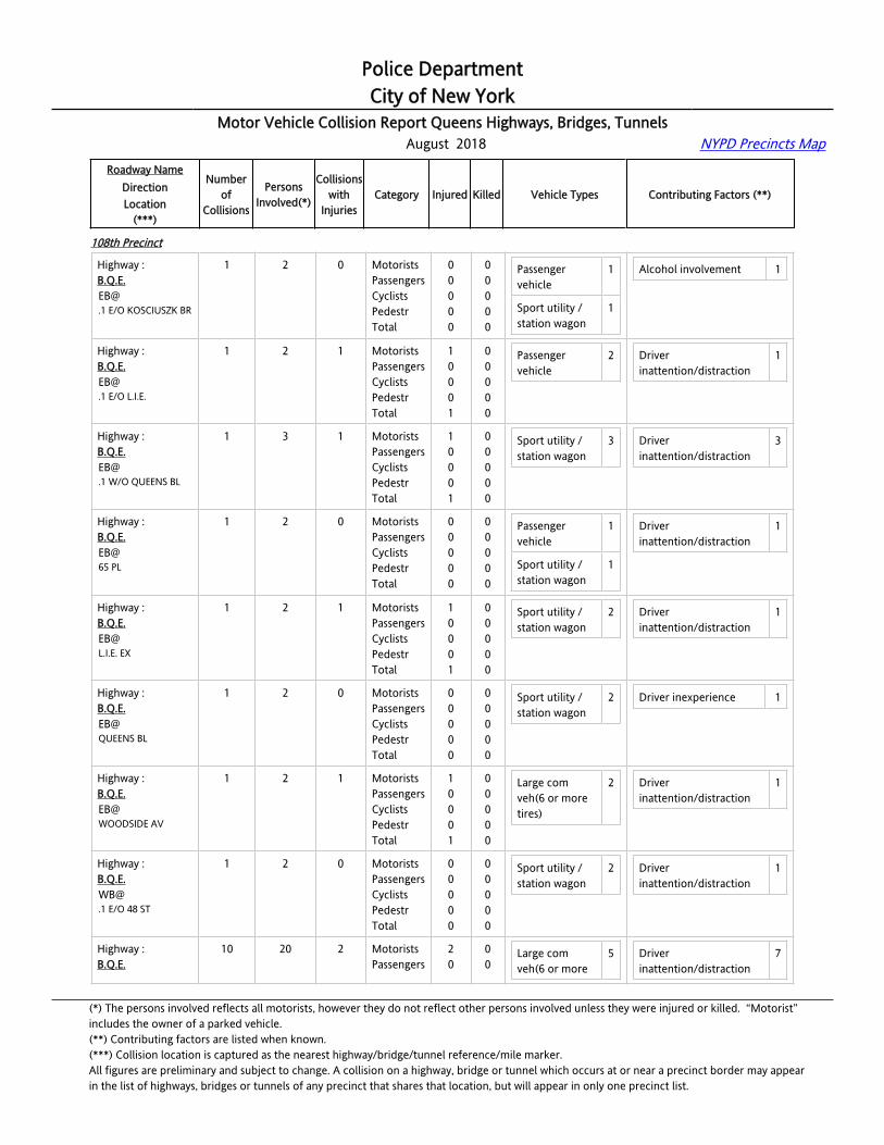
Police DepartmentCity of New York
Motor Vehicle Collision Report Queens Highways, Bridges, Tunnels August 2018 NYPD Precincts Map
Roadway NameDirectionLocation
(***)
Numberof
Collisions
PersonsInvolved(*)
Collisionswith
InjuriesCategory Injured Killed Vehicle Types Contributing Factors (**)
108th Precinct
Highway :[email protected] E/O KOSCIUSZK BR
1 2 0 MotoristsPassengersCyclistsPedestrTotal
00000
00000
Passenger vehicle
1
Sport utility / station wagon
1
Alcohol involvement 1
Highway :[email protected] E/O L.I.E.
1 2 1 MotoristsPassengersCyclistsPedestrTotal
10001
00000
Passenger vehicle
2 Driver inattention/distraction
1
Highway :[email protected] W/O QUEENS BL
1 3 1 MotoristsPassengersCyclistsPedestrTotal
10001
00000
Sport utility / station wagon
3 Driver inattention/distraction
3
Highway :B.Q.E.EB@65 PL
1 2 0 MotoristsPassengersCyclistsPedestrTotal
00000
00000
Passenger vehicle
1
Sport utility / station wagon
1
Driver inattention/distraction
1
Highway :[email protected]. EX
1 2 1 MotoristsPassengersCyclistsPedestrTotal
10001
00000
Sport utility / station wagon
2 Driver inattention/distraction
1
Highway :B.Q.E.EB@QUEENS BL
1 2 0 MotoristsPassengersCyclistsPedestrTotal
00000
00000
Sport utility / station wagon
2 Driver inexperience 1
Highway :B.Q.E.EB@WOODSIDE AV
1 2 1 MotoristsPassengersCyclistsPedestrTotal
10001
00000
Large com veh(6 or more tires)
2 Driver inattention/distraction
1
Highway :[email protected] E/O 48 ST
1 2 0 MotoristsPassengersCyclistsPedestrTotal
00000
00000
Sport utility / station wagon
2 Driver inattention/distraction
1
Highway :B.Q.E.
10 20 2 MotoristsPassengers
20
00
Large com veh(6 or more
5 Driver inattention/distraction
7
(*) The persons involved reflects all motorists, however they do not reflect other persons involved unless they were injured or killed. “Motorist” includes the owner of a parked vehicle.(**) Contributing factors are listed when known.(***) Collision location is captured as the nearest highway/bridge/tunnel reference/mile marker.All figures are preliminary and subject to change. A collision on a highway, bridge or tunnel which occurs at or near a precinct border may appearin the list of highways, bridges or tunnels of any precinct that shares that location, but will appear in only one precinct list.

Police DepartmentCity of New York
Motor Vehicle Collision Report Queens Highways, Bridges, Tunnels August 2018 NYPD Precincts Map
Roadway NameDirectionLocation
(***)
Numberof
Collisions
PersonsInvolved(*)
Collisionswith
InjuriesCategory Injured Killed Vehicle Types Contributing Factors (**)
108th Precinct
[email protected] E/O KOSCIUSZKO BR
CyclistsPedestrTotal
002
000
tires)
Passenger vehicle
6
Pick-up truck 1
Sport utility / station wagon
7
Following too closely 2
Unsafe lane changing 1
Highway :[email protected] E/O KOSCIUSZKO BR
1 2 1 MotoristsPassengersCyclistsPedestrTotal
10001
00000
Sport utility / station wagon
2 Following too closely 1
Highway :[email protected] E/O KOSCIUSZKO BR
1 2 0 MotoristsPassengersCyclistsPedestrTotal
00000
00000
Sport utility / station wagon
1
Highway :[email protected] E/O KOSCIUSZKO BR
1 2 0 MotoristsPassengersCyclistsPedestrTotal
00000
00000
Large com veh(6 or more tires)
2 Driver inattention/distraction
2
Highway :[email protected] E/O KOSCIUSZKO BR
1 2 0 MotoristsPassengersCyclistsPedestrTotal
00000
00000
Sport utility / station wagon
2 Driver inattention/distraction
1
Highway :[email protected] E/O KOSCIUSZKO BR
1 2 1 MotoristsPassengersCyclistsPedestrTotal
10001
00000
Passenger vehicle
1
Sport utility / station wagon
1
Driver inattention/distraction
1
Highway :[email protected] E/O KOSCIUSZKO BR
1 2 0 MotoristsPassengersCyclistsPedestrTotal
00000
00000
Passenger vehicle
1
Pick-up truck 1
Driver inattention/distraction
2
Highway :[email protected] E/O KOSCIUSZKO BR
1 2 0 MotoristsPassengersCyclistsPedestrTotal
00000
00000
Large com veh(6 or more tires)
1
Passenger 1
Driver inattention/distraction
1
(*) The persons involved reflects all motorists, however they do not reflect other persons involved unless they were injured or killed. “Motorist” includes the owner of a parked vehicle.(**) Contributing factors are listed when known.(***) Collision location is captured as the nearest highway/bridge/tunnel reference/mile marker.All figures are preliminary and subject to change. A collision on a highway, bridge or tunnel which occurs at or near a precinct border may appearin the list of highways, bridges or tunnels of any precinct that shares that location, but will appear in only one precinct list.

Police DepartmentCity of New York
Motor Vehicle Collision Report Queens Highways, Bridges, Tunnels August 2018 NYPD Precincts Map
Roadway NameDirectionLocation
(***)
Numberof
Collisions
PersonsInvolved(*)
Collisionswith
InjuriesCategory Injured Killed Vehicle Types Contributing Factors (**)
108th Precinct
vehicle
Highway :[email protected] E/O KOSCIUSZKO BR
1 2 0 MotoristsPassengersCyclistsPedestrTotal
00000
00000
Large com veh(6 or more tires)
1
Passenger vehicle
1
Highway :[email protected] E/O KOSCIUSZKO BR
1 2 0 MotoristsPassengersCyclistsPedestrTotal
00000
00000
Passenger vehicle
1
Sport utility / station wagon
1
Following too closely 1
Highway :[email protected] E/O KOSCIUSZKO BR
1 2 0 MotoristsPassengersCyclistsPedestrTotal
00000
00000
Large com veh(6 or more tires)
1
Passenger vehicle
1
Unsafe lane changing 1
Highway :[email protected] E/O L.I.E.
5 12 2 MotoristsPassengersCyclistsPedestrTotal
12003
00000
Large com veh(6 or more tires)
1
Passenger vehicle
3
Pick-up truck 1
Sport utility / station wagon
3
Taxi vehicle 1
Driver inattention/distraction
4
Following too closely 1
Unsafe lane changing 2
Highway :[email protected] E/O L.I.E.
1 3 1 MotoristsPassengersCyclistsPedestrTotal
01001
00000
Passenger vehicle
2 Following too closely 1
Unsafe lane changing 1
Highway :[email protected] E/O L.I.E.
1 2 0 MotoristsPassengersCyclistsPedestrTotal
00000
00000
Pick-up truck 1
Sport utility / station wagon
1
Unsafe lane changing 1
Highway :B.Q.E.WB@
1 2 0 MotoristsPassengersCyclists
000
000
Large com veh(6 or more
1 Driver inattention/distraction
2
(*) The persons involved reflects all motorists, however they do not reflect other persons involved unless they were injured or killed. “Motorist” includes the owner of a parked vehicle.(**) Contributing factors are listed when known.(***) Collision location is captured as the nearest highway/bridge/tunnel reference/mile marker.All figures are preliminary and subject to change. A collision on a highway, bridge or tunnel which occurs at or near a precinct border may appearin the list of highways, bridges or tunnels of any precinct that shares that location, but will appear in only one precinct list.
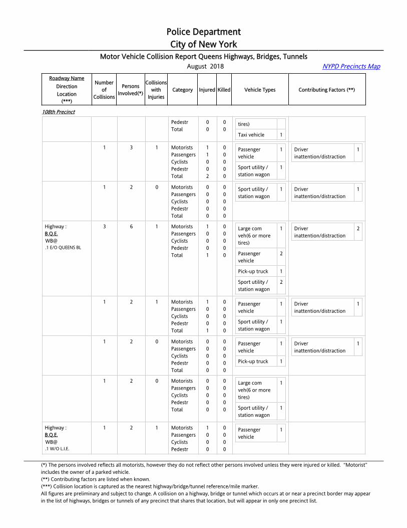
Police DepartmentCity of New York
Motor Vehicle Collision Report Queens Highways, Bridges, Tunnels August 2018 NYPD Precincts Map
Roadway NameDirectionLocation
(***)
Numberof
Collisions
PersonsInvolved(*)
Collisionswith
InjuriesCategory Injured Killed Vehicle Types Contributing Factors (**)
108th Precinct
.1 E/O L.I.E. PedestrTotal
00
00
tires)
Taxi vehicle 1
Highway :[email protected] E/O L.I.E.
1 3 1 MotoristsPassengersCyclistsPedestrTotal
11002
00000
Passenger vehicle
1
Sport utility / station wagon
1
Driver inattention/distraction
1
Highway :[email protected] E/O L.I.E.
1 2 0 MotoristsPassengersCyclistsPedestrTotal
00000
00000
Sport utility / station wagon
1 Driver inattention/distraction
1
Highway :[email protected] E/O QUEENS BL
3 6 1 MotoristsPassengersCyclistsPedestrTotal
10001
00000
Large com veh(6 or more tires)
1
Passenger vehicle
2
Pick-up truck 1
Sport utility / station wagon
2
Driver inattention/distraction
2
Highway :[email protected] E/O QUEENS BL
1 2 1 MotoristsPassengersCyclistsPedestrTotal
10001
00000
Passenger vehicle
1
Sport utility / station wagon
1
Driver inattention/distraction
1
Highway :[email protected] E/O QUEENS BL
1 2 0 MotoristsPassengersCyclistsPedestrTotal
00000
00000
Passenger vehicle
1
Pick-up truck 1
Driver inattention/distraction
1
Highway :[email protected] E/O QUEENS BL
1 2 0 MotoristsPassengersCyclistsPedestrTotal
00000
00000
Large com veh(6 or more tires)
1
Sport utility / station wagon
1
Highway :[email protected] W/O L.I.E.
1 2 1 MotoristsPassengersCyclistsPedestr
1000
0000
Passenger vehicle
1
(*) The persons involved reflects all motorists, however they do not reflect other persons involved unless they were injured or killed. “Motorist” includes the owner of a parked vehicle.(**) Contributing factors are listed when known.(***) Collision location is captured as the nearest highway/bridge/tunnel reference/mile marker.All figures are preliminary and subject to change. A collision on a highway, bridge or tunnel which occurs at or near a precinct border may appearin the list of highways, bridges or tunnels of any precinct that shares that location, but will appear in only one precinct list.
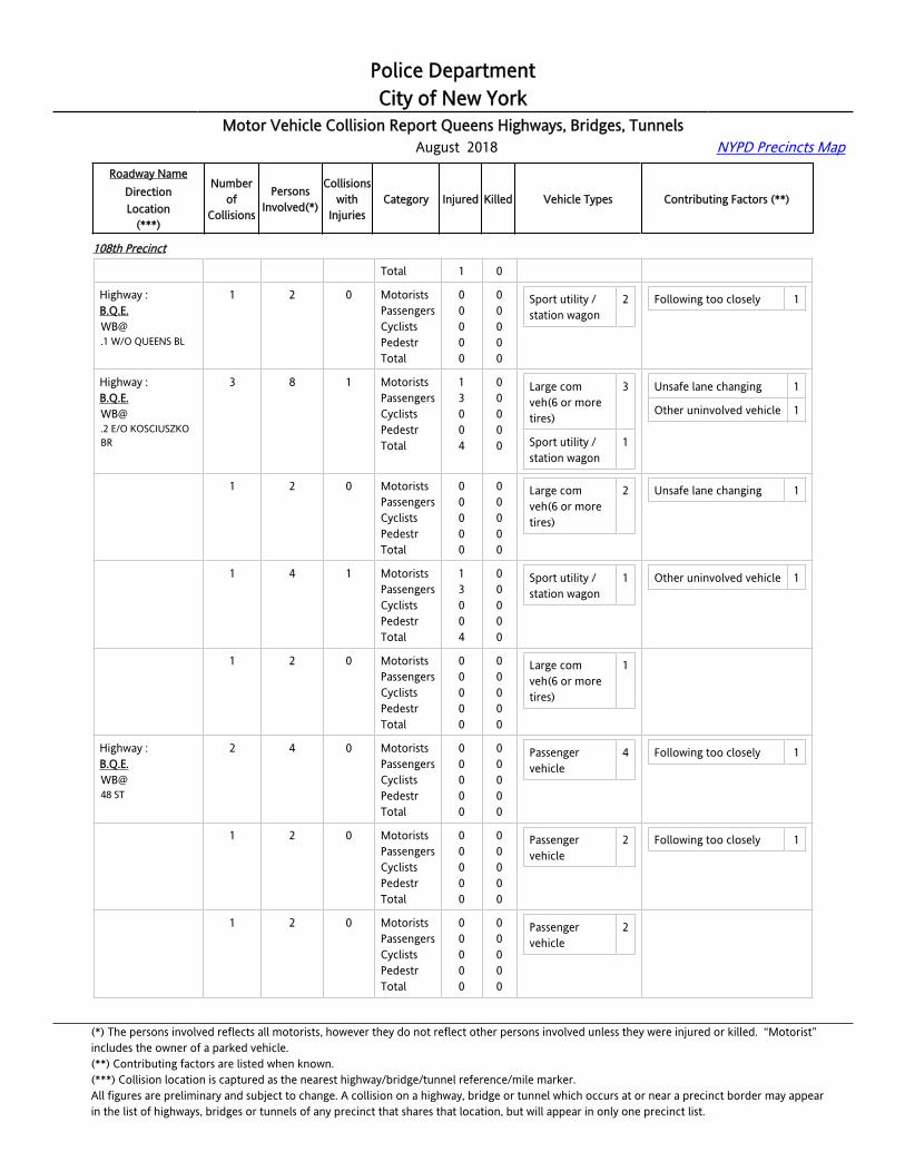
Police DepartmentCity of New York
Motor Vehicle Collision Report Queens Highways, Bridges, Tunnels August 2018 NYPD Precincts Map
Roadway NameDirectionLocation
(***)
Numberof
Collisions
PersonsInvolved(*)
Collisionswith
InjuriesCategory Injured Killed Vehicle Types Contributing Factors (**)
108th Precinct
Total 1 0
Highway :[email protected] W/O QUEENS BL
1 2 0 MotoristsPassengersCyclistsPedestrTotal
00000
00000
Sport utility / station wagon
2 Following too closely 1
Highway :[email protected] E/O KOSCIUSZKO BR
3 8 1 MotoristsPassengersCyclistsPedestrTotal
13004
00000
Large com veh(6 or more tires)
3
Sport utility / station wagon
1
Unsafe lane changing 1
Other uninvolved vehicle 1
Highway :[email protected] E/O KOSCIUSZKO BR
1 2 0 MotoristsPassengersCyclistsPedestrTotal
00000
00000
Large com veh(6 or more tires)
2 Unsafe lane changing 1
Highway :[email protected] E/O KOSCIUSZKO BR
1 4 1 MotoristsPassengersCyclistsPedestrTotal
13004
00000
Sport utility / station wagon
1 Other uninvolved vehicle 1
Highway :[email protected] E/O KOSCIUSZKO BR
1 2 0 MotoristsPassengersCyclistsPedestrTotal
00000
00000
Large com veh(6 or more tires)
1
Highway :B.Q.E.WB@48 ST
2 4 0 MotoristsPassengersCyclistsPedestrTotal
00000
00000
Passenger vehicle
4 Following too closely 1
Highway :B.Q.E.WB@48 ST
1 2 0 MotoristsPassengersCyclistsPedestrTotal
00000
00000
Passenger vehicle
2 Following too closely 1
Highway :B.Q.E.WB@48 ST
1 2 0 MotoristsPassengersCyclistsPedestrTotal
00000
00000
Passenger vehicle
2
(*) The persons involved reflects all motorists, however they do not reflect other persons involved unless they were injured or killed. “Motorist” includes the owner of a parked vehicle.(**) Contributing factors are listed when known.(***) Collision location is captured as the nearest highway/bridge/tunnel reference/mile marker.All figures are preliminary and subject to change. A collision on a highway, bridge or tunnel which occurs at or near a precinct border may appearin the list of highways, bridges or tunnels of any precinct that shares that location, but will appear in only one precinct list.
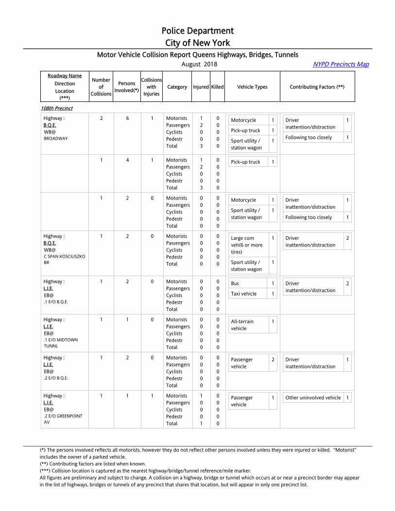
Police DepartmentCity of New York
Motor Vehicle Collision Report Queens Highways, Bridges, Tunnels August 2018 NYPD Precincts Map
Roadway NameDirectionLocation
(***)
Numberof
Collisions
PersonsInvolved(*)
Collisionswith
InjuriesCategory Injured Killed Vehicle Types Contributing Factors (**)
108th Precinct
Highway :B.Q.E.WB@BROADWAY
2 6 1 MotoristsPassengersCyclistsPedestrTotal
12003
00000
Motorcycle 1
Pick-up truck 1
Sport utility / station wagon
1
Driver inattention/distraction
1
Following too closely 1
Highway :B.Q.E.WB@BROADWAY
1 4 1 MotoristsPassengersCyclistsPedestrTotal
12003
00000
Pick-up truck 1
Highway :B.Q.E.WB@BROADWAY
1 2 0 MotoristsPassengersCyclistsPedestrTotal
00000
00000
Motorcycle 1
Sport utility / station wagon
1
Driver inattention/distraction
1
Following too closely 1
Highway :B.Q.E.WB@C SPAN KOSCIUSZKO BR
1 2 0 MotoristsPassengersCyclistsPedestrTotal
00000
00000
Large com veh(6 or more tires)
1
Sport utility / station wagon
1
Driver inattention/distraction
2
Highway :[email protected] E/O B.Q.E.
1 2 0 MotoristsPassengersCyclistsPedestrTotal
00000
00000
Bus 1
Taxi vehicle 1
Driver inattention/distraction
2
Highway :[email protected] E/O MIDTOWN TUNNL
1 1 0 MotoristsPassengersCyclistsPedestrTotal
00000
00000
All-terrain vehicle
1
Highway :[email protected] E/O B.Q.E.
1 2 0 MotoristsPassengersCyclistsPedestrTotal
00000
00000
Passenger vehicle
2 Driver inattention/distraction
1
Highway :[email protected] E/O GREENPOINT AV
1 1 1 MotoristsPassengersCyclistsPedestrTotal
10001
00000
Passenger vehicle
1 Other uninvolved vehicle 1
(*) The persons involved reflects all motorists, however they do not reflect other persons involved unless they were injured or killed. “Motorist” includes the owner of a parked vehicle.(**) Contributing factors are listed when known.(***) Collision location is captured as the nearest highway/bridge/tunnel reference/mile marker.All figures are preliminary and subject to change. A collision on a highway, bridge or tunnel which occurs at or near a precinct border may appearin the list of highways, bridges or tunnels of any precinct that shares that location, but will appear in only one precinct list.

Police DepartmentCity of New York
Motor Vehicle Collision Report Queens Highways, Bridges, Tunnels August 2018 NYPD Precincts Map
Roadway NameDirectionLocation
(***)
Numberof
Collisions
PersonsInvolved(*)
Collisionswith
InjuriesCategory Injured Killed Vehicle Types Contributing Factors (**)
108th Precinct
Highway :[email protected] E/O MIDTOWN TUNNL
1 4 1 MotoristsPassengersCyclistsPedestrTotal
11002
00000
Passenger vehicle
1
Sport utility / station wagon
1
Taxi vehicle 1
Following too closely 1
Highway :L.I.E.EB@BROOKLYN QUEENS EXP
1 3 1 MotoristsPassengersCyclistsPedestrTotal
11002
00000
Passenger vehicle
1
Sport utility / station wagon
1
Unsafe speed 1
Highway :L.I.E.EB@GREENPOINT AV
1 2 0 MotoristsPassengersCyclistsPedestrTotal
00000
00000
Passenger vehicle
2 Following too closely 1
Highway :[email protected] E/O B.Q.E.
3 6 0 MotoristsPassengersCyclistsPedestrTotal
00000
00000
Passenger vehicle
1
Pick-up truck 1
Sport utility / station wagon
3
Taxi vehicle 1
Driver inattention/distraction
3
Highway :[email protected] E/O B.Q.E.
1 2 0 MotoristsPassengersCyclistsPedestrTotal
00000
00000
Pick-up truck 1
Taxi vehicle 1
Driver inattention/distraction
1
Highway :[email protected] E/O B.Q.E.
1 2 0 MotoristsPassengersCyclistsPedestrTotal
00000
00000
Passenger vehicle
1
Sport utility / station wagon
1
Driver inattention/distraction
1
Highway :[email protected] E/O B.Q.E.
1 2 0 MotoristsPassengersCyclistsPedestrTotal
00000
00000
Sport utility / station wagon
2 Driver inattention/distraction
1
Highway :L.I.E.WB@
3 6 0 MotoristsPassengersCyclists
000
000
Passenger vehicle
1 Driver inattention/distraction
2
(*) The persons involved reflects all motorists, however they do not reflect other persons involved unless they were injured or killed. “Motorist” includes the owner of a parked vehicle.(**) Contributing factors are listed when known.(***) Collision location is captured as the nearest highway/bridge/tunnel reference/mile marker.All figures are preliminary and subject to change. A collision on a highway, bridge or tunnel which occurs at or near a precinct border may appearin the list of highways, bridges or tunnels of any precinct that shares that location, but will appear in only one precinct list.

Police DepartmentCity of New York
Motor Vehicle Collision Report Queens Highways, Bridges, Tunnels August 2018 NYPD Precincts Map
Roadway NameDirectionLocation
(***)
Numberof
Collisions
PersonsInvolved(*)
Collisionswith
InjuriesCategory Injured Killed Vehicle Types Contributing Factors (**)
108th Precinct
.1 E/O GREENPOINT AV
PedestrTotal
00
00
Sport utility / station wagon
3
Taxi vehicle 1
Unsafe lane changing 1
Highway :[email protected] E/O GREENPOINT AV
1 2 0 MotoristsPassengersCyclistsPedestrTotal
00000
00000
Sport utility / station wagon
2 Driver inattention/distraction
2
Highway :[email protected] E/O GREENPOINT AV
1 2 0 MotoristsPassengersCyclistsPedestrTotal
00000
00000
Passenger vehicle
1
Taxi vehicle 1
Unsafe lane changing 1
Highway :[email protected] E/O GREENPOINT AV
1 2 0 MotoristsPassengersCyclistsPedestrTotal
00000
00000
Sport utility / station wagon
1
Highway :[email protected] E/O MIDTOWN TUNNL
2 4 0 MotoristsPassengersCyclistsPedestrTotal
00000
00000
Bus 1
Passenger vehicle
2
Pick-up truck 1
Passing too closely 2
Highway :[email protected] E/O MIDTOWN TUNNL
1 2 0 MotoristsPassengersCyclistsPedestrTotal
00000
00000
Passenger vehicle
1
Pick-up truck 1
Highway :[email protected] E/O MIDTOWN TUNNL
1 2 0 MotoristsPassengersCyclistsPedestrTotal
00000
00000
Bus 1
Passenger vehicle
1
Passing too closely 2
Highway :[email protected] E/O VAN DAM ST
1 5 1 MotoristsPassengersCyclistsPedestrTotal
13004
00000
Passenger vehicle
1
Taxi vehicle 1
Driver inattention/distraction
1
Highway :L.I.E.WB@
1 2 0 MotoristsPassengersCyclists
000
000
Passenger vehicle
1 Driver inattention/distraction
1
(*) The persons involved reflects all motorists, however they do not reflect other persons involved unless they were injured or killed. “Motorist” includes the owner of a parked vehicle.(**) Contributing factors are listed when known.(***) Collision location is captured as the nearest highway/bridge/tunnel reference/mile marker.All figures are preliminary and subject to change. A collision on a highway, bridge or tunnel which occurs at or near a precinct border may appearin the list of highways, bridges or tunnels of any precinct that shares that location, but will appear in only one precinct list.
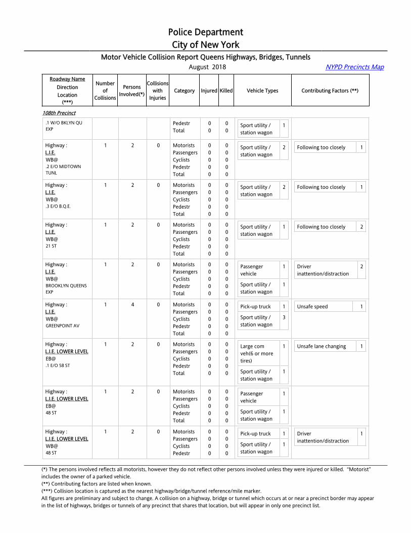
Police DepartmentCity of New York
Motor Vehicle Collision Report Queens Highways, Bridges, Tunnels August 2018 NYPD Precincts Map
Roadway NameDirectionLocation
(***)
Numberof
Collisions
PersonsInvolved(*)
Collisionswith
InjuriesCategory Injured Killed Vehicle Types Contributing Factors (**)
108th Precinct
.1 W/O BKLYN QU EXP
PedestrTotal
00
00
Sport utility / station wagon
1
Highway :[email protected] E/O MIDTOWN TUNL
1 2 0 MotoristsPassengersCyclistsPedestrTotal
00000
00000
Sport utility / station wagon
2 Following too closely 1
Highway :[email protected] E/O B.Q.E.
1 2 0 MotoristsPassengersCyclistsPedestrTotal
00000
00000
Sport utility / station wagon
2 Following too closely 1
Highway :L.I.E.WB@21 ST
1 2 0 MotoristsPassengersCyclistsPedestrTotal
00000
00000
Sport utility / station wagon
1 Following too closely 2
Highway :L.I.E.WB@BROOKLYN QUEENS EXP
1 2 0 MotoristsPassengersCyclistsPedestrTotal
00000
00000
Passenger vehicle
1
Sport utility / station wagon
1
Driver inattention/distraction
2
Highway :L.I.E.WB@GREENPOINT AV
1 4 0 MotoristsPassengersCyclistsPedestrTotal
00000
00000
Pick-up truck 1
Sport utility / station wagon
3
Unsafe speed 1
Highway :L.I.E. LOWER [email protected] E/O 58 ST
1 2 0 MotoristsPassengersCyclistsPedestrTotal
00000
00000
Large com veh(6 or more tires)
1
Sport utility / station wagon
1
Unsafe lane changing 1
Highway :L.I.E. LOWER LEVELEB@48 ST
1 2 0 MotoristsPassengersCyclistsPedestrTotal
00000
00000
Passenger vehicle
1
Sport utility / station wagon
1
Highway :L.I.E. LOWER LEVELWB@48 ST
1 2 0 MotoristsPassengersCyclistsPedestr
0000
0000
Pick-up truck 1
Sport utility / station wagon
1
Driver inattention/distraction
1
(*) The persons involved reflects all motorists, however they do not reflect other persons involved unless they were injured or killed. “Motorist” includes the owner of a parked vehicle.(**) Contributing factors are listed when known.(***) Collision location is captured as the nearest highway/bridge/tunnel reference/mile marker.All figures are preliminary and subject to change. A collision on a highway, bridge or tunnel which occurs at or near a precinct border may appearin the list of highways, bridges or tunnels of any precinct that shares that location, but will appear in only one precinct list.

Police DepartmentCity of New York
Motor Vehicle Collision Report Queens Highways, Bridges, Tunnels August 2018 NYPD Precincts Map
Roadway NameDirectionLocation
(***)
Numberof
Collisions
PersonsInvolved(*)
Collisionswith
InjuriesCategory Injured Killed Vehicle Types Contributing Factors (**)
108th Precinct
Total 0 0
Tunnel : QMT N TUBENB@QNS SIDE
2 4 0 MotoristsPassengersCyclistsPedestrTotal
00000
00000
Passenger vehicle
1
Sport utility / station wagon
1
Taxi vehicle 2
Failure to yield right-of-way
1
Unsafe lane changing 1
Tunnel : QMT N TUBENB@QNS SIDE
1 2 0 MotoristsPassengersCyclistsPedestrTotal
00000
00000
Taxi vehicle 2 Unsafe lane changing 1
Tunnel : QMT N TUBENB@QNS SIDE
1 2 0 MotoristsPassengersCyclistsPedestrTotal
00000
00000
Passenger vehicle
1
Sport utility / station wagon
1
Failure to yield right-of-way
1
Tunnel : QMT S TUBESB@QNS SIDE
2 7 1 MotoristsPassengersCyclistsPedestrTotal
12003
00000
Passenger vehicle
2
Sport utility / station wagon
2
Taxi vehicle 1
Alcohol involvement 1
Following too closely 1
Tunnel : QMT S TUBESB@QNS SIDE
1 2 0 MotoristsPassengersCyclistsPedestrTotal
00000
00000
Sport utility / station wagon
1
Taxi vehicle 1
Following too closely 1
Tunnel : QMT S TUBESB@QNS SIDE
1 5 1 MotoristsPassengersCyclistsPedestrTotal
12003
00000
Passenger vehicle
2
Sport utility / station wagon
1
Alcohol involvement 1
Bridge : QNSBORO BR LOWEREB@QNS SIDE
7 18 1 MotoristsPassengersCyclistsPedestrTotal
10001
00000
Passenger vehicle
7
Pick-up truck 1
Sport utility / station wagon
7
Taxi vehicle 3
Driver inattention/distraction
8
Other uninvolved vehicle 1
(*) The persons involved reflects all motorists, however they do not reflect other persons involved unless they were injured or killed. “Motorist” includes the owner of a parked vehicle.(**) Contributing factors are listed when known.(***) Collision location is captured as the nearest highway/bridge/tunnel reference/mile marker.All figures are preliminary and subject to change. A collision on a highway, bridge or tunnel which occurs at or near a precinct border may appearin the list of highways, bridges or tunnels of any precinct that shares that location, but will appear in only one precinct list.
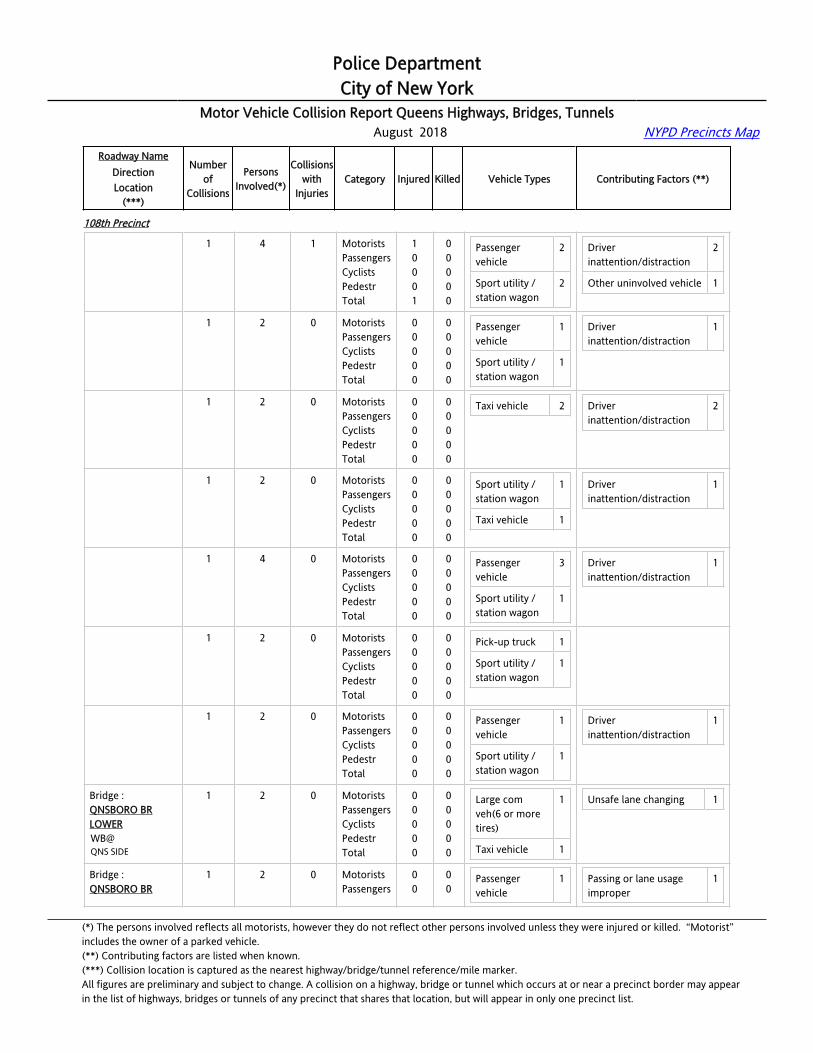
Police DepartmentCity of New York
Motor Vehicle Collision Report Queens Highways, Bridges, Tunnels August 2018 NYPD Precincts Map
Roadway NameDirectionLocation
(***)
Numberof
Collisions
PersonsInvolved(*)
Collisionswith
InjuriesCategory Injured Killed Vehicle Types Contributing Factors (**)
108th Precinct
Bridge : QNSBORO BR LOWEREB@QNS SIDE
1 4 1 MotoristsPassengersCyclistsPedestrTotal
10001
00000
Passenger vehicle
2
Sport utility / station wagon
2
Driver inattention/distraction
2
Other uninvolved vehicle 1
Bridge : QNSBORO BR LOWEREB@QNS SIDE
1 2 0 MotoristsPassengersCyclistsPedestrTotal
00000
00000
Passenger vehicle
1
Sport utility / station wagon
1
Driver inattention/distraction
1
Bridge : QNSBORO BR LOWEREB@QNS SIDE
1 2 0 MotoristsPassengersCyclistsPedestrTotal
00000
00000
Taxi vehicle 2 Driver inattention/distraction
2
Bridge : QNSBORO BR LOWEREB@QNS SIDE
1 2 0 MotoristsPassengersCyclistsPedestrTotal
00000
00000
Sport utility / station wagon
1
Taxi vehicle 1
Driver inattention/distraction
1
Bridge : QNSBORO BR LOWEREB@QNS SIDE
1 4 0 MotoristsPassengersCyclistsPedestrTotal
00000
00000
Passenger vehicle
3
Sport utility / station wagon
1
Driver inattention/distraction
1
Bridge : QNSBORO BR LOWEREB@QNS SIDE
1 2 0 MotoristsPassengersCyclistsPedestrTotal
00000
00000
Pick-up truck 1
Sport utility / station wagon
1
Bridge : QNSBORO BR LOWEREB@QNS SIDE
1 2 0 MotoristsPassengersCyclistsPedestrTotal
00000
00000
Passenger vehicle
1
Sport utility / station wagon
1
Driver inattention/distraction
1
Bridge : QNSBORO BR LOWERWB@QNS SIDE
1 2 0 MotoristsPassengersCyclistsPedestrTotal
00000
00000
Large com veh(6 or more tires)
1
Taxi vehicle 1
Unsafe lane changing 1
Bridge : QNSBORO BR
1 2 0 MotoristsPassengers
00
00
Passenger vehicle
1 Passing or lane usage improper
1
(*) The persons involved reflects all motorists, however they do not reflect other persons involved unless they were injured or killed. “Motorist” includes the owner of a parked vehicle.(**) Contributing factors are listed when known.(***) Collision location is captured as the nearest highway/bridge/tunnel reference/mile marker.All figures are preliminary and subject to change. A collision on a highway, bridge or tunnel which occurs at or near a precinct border may appearin the list of highways, bridges or tunnels of any precinct that shares that location, but will appear in only one precinct list.
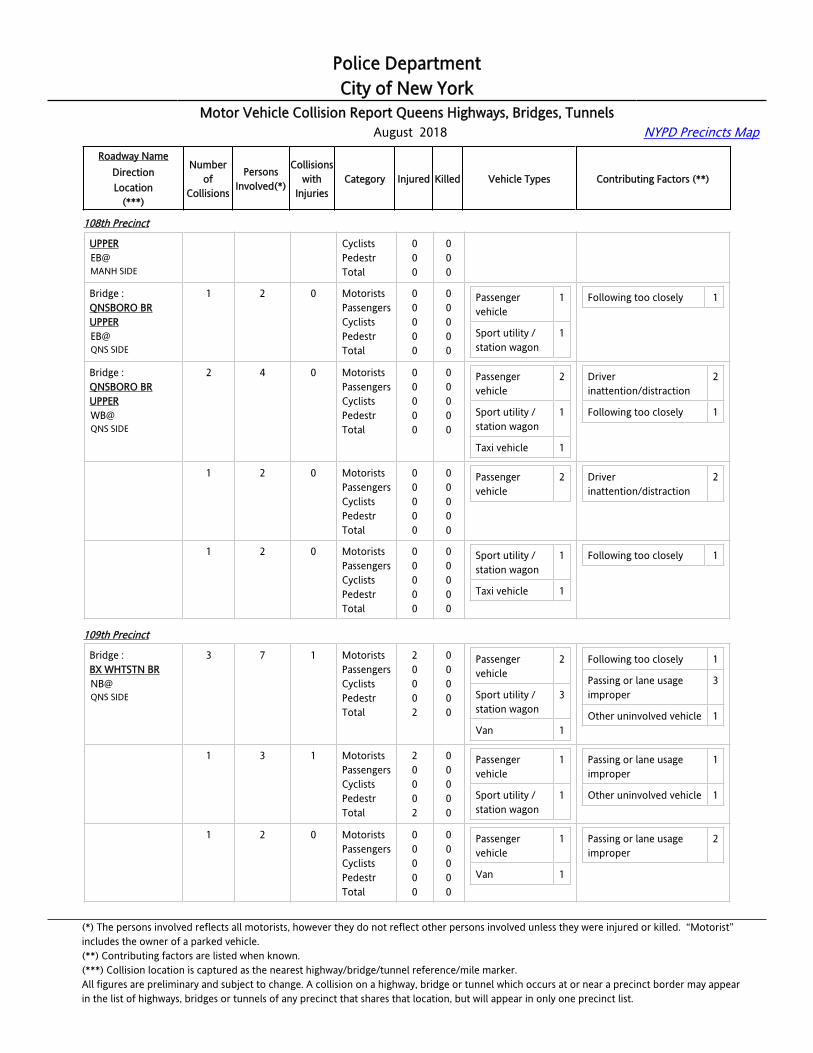
Police DepartmentCity of New York
Motor Vehicle Collision Report Queens Highways, Bridges, Tunnels August 2018 NYPD Precincts Map
Roadway NameDirectionLocation
(***)
Numberof
Collisions
PersonsInvolved(*)
Collisionswith
InjuriesCategory Injured Killed Vehicle Types Contributing Factors (**)
108th Precinct
UPPEREB@MANH SIDE
CyclistsPedestrTotal
000
000
Bridge : QNSBORO BR UPPEREB@QNS SIDE
1 2 0 MotoristsPassengersCyclistsPedestrTotal
00000
00000
Passenger vehicle
1
Sport utility / station wagon
1
Following too closely 1
Bridge : QNSBORO BR UPPERWB@QNS SIDE
2 4 0 MotoristsPassengersCyclistsPedestrTotal
00000
00000
Passenger vehicle
2
Sport utility / station wagon
1
Taxi vehicle 1
Driver inattention/distraction
2
Following too closely 1
Bridge : QNSBORO BR UPPERWB@QNS SIDE
1 2 0 MotoristsPassengersCyclistsPedestrTotal
00000
00000
Passenger vehicle
2 Driver inattention/distraction
2
Bridge : QNSBORO BR UPPERWB@QNS SIDE
1 2 0 MotoristsPassengersCyclistsPedestrTotal
00000
00000
Sport utility / station wagon
1
Taxi vehicle 1
Following too closely 1
109th Precinct
Bridge : BX WHTSTN BRNB@QNS SIDE
3 7 1 MotoristsPassengersCyclistsPedestrTotal
20002
00000
Passenger vehicle
2
Sport utility / station wagon
3
Van 1
Following too closely 1
Passing or lane usage improper
3
Other uninvolved vehicle 1
Bridge : BX WHTSTN BRNB@QNS SIDE
1 3 1 MotoristsPassengersCyclistsPedestrTotal
20002
00000
Passenger vehicle
1
Sport utility / station wagon
1
Passing or lane usage improper
1
Other uninvolved vehicle 1
Bridge : BX WHTSTN BRNB@QNS SIDE
1 2 0 MotoristsPassengersCyclistsPedestrTotal
00000
00000
Passenger vehicle
1
Van 1
Passing or lane usage improper
2
(*) The persons involved reflects all motorists, however they do not reflect other persons involved unless they were injured or killed. “Motorist” includes the owner of a parked vehicle.(**) Contributing factors are listed when known.(***) Collision location is captured as the nearest highway/bridge/tunnel reference/mile marker.All figures are preliminary and subject to change. A collision on a highway, bridge or tunnel which occurs at or near a precinct border may appearin the list of highways, bridges or tunnels of any precinct that shares that location, but will appear in only one precinct list.

Police DepartmentCity of New York
Motor Vehicle Collision Report Queens Highways, Bridges, Tunnels August 2018 NYPD Precincts Map
Roadway NameDirectionLocation
(***)
Numberof
Collisions
PersonsInvolved(*)
Collisionswith
InjuriesCategory Injured Killed Vehicle Types Contributing Factors (**)
109th Precinct
Bridge : BX WHTSTN BRNB@QNS SIDE
1 2 0 MotoristsPassengersCyclistsPedestrTotal
00000
00000
Sport utility / station wagon
2 Following too closely 1
Bridge : BX WHTSTN BRSB@QNS SIDE
42 122 14 MotoristsPassengersCyclistsPedestrTotal
182000
38
00000
Large com veh(6 or more tires)
5
Passenger vehicle
28
Pick-up truck 4
Sport utility / station wagon
54
Taxi vehicle 4
Alcohol involvement 3
Driver inattention/distraction
1
Following too closely 40
Unsafe lane changing 1
Other uninvolved vehicle
6
Bridge : BX WHTSTN BRSB@QNS SIDE
1 2 0 MotoristsPassengersCyclistsPedestrTotal
00000
00000
Pick-up truck 1
Sport utility / station wagon
1
Following too closely 1
Other uninvolved vehicle 1
Bridge : BX WHTSTN BRSB@QNS SIDE
1 2 0 MotoristsPassengersCyclistsPedestrTotal
00000
00000
Passenger vehicle
1
Sport utility / station wagon
1
Following too closely 1
Bridge : BX WHTSTN BRSB@QNS SIDE
1 2 0 MotoristsPassengersCyclistsPedestrTotal
00000
00000
Sport utility / station wagon
2 Unsafe lane changing 1
Bridge : BX WHTSTN BRSB@QNS SIDE
1 2 0 MotoristsPassengersCyclistsPedestrTotal
00000
00000
Passenger vehicle
1
Sport utility / station wagon
1
Following too closely 1
Bridge : BX WHTSTN BRSB@QNS SIDE
1 2 0 MotoristsPassengersCyclistsPedestrTotal
00000
00000
Passenger vehicle
1
Sport utility / station wagon
1
Following too closely 1
Bridge : 1 2 0 Motorists 0 0 Sport utility / 2 Following too closely 1
(*) The persons involved reflects all motorists, however they do not reflect other persons involved unless they were injured or killed. “Motorist” includes the owner of a parked vehicle.(**) Contributing factors are listed when known.(***) Collision location is captured as the nearest highway/bridge/tunnel reference/mile marker.All figures are preliminary and subject to change. A collision on a highway, bridge or tunnel which occurs at or near a precinct border may appearin the list of highways, bridges or tunnels of any precinct that shares that location, but will appear in only one precinct list.

Police DepartmentCity of New York
Motor Vehicle Collision Report Queens Highways, Bridges, Tunnels August 2018 NYPD Precincts Map
Roadway NameDirectionLocation
(***)
Numberof
Collisions
PersonsInvolved(*)
Collisionswith
InjuriesCategory Injured Killed Vehicle Types Contributing Factors (**)
109th Precinct
BX WHTSTN BRSB@QNS SIDE
PassengersCyclistsPedestrTotal
0000
0000
station wagon
Bridge : BX WHTSTN BRSB@QNS SIDE
1 2 0 MotoristsPassengersCyclistsPedestrTotal
00000
00000
Passenger vehicle
1
Sport utility / station wagon
1
Following too closely 1
Bridge : BX WHTSTN BRSB@QNS SIDE
1 4 1 MotoristsPassengersCyclistsPedestrTotal
12003
00000
Passenger vehicle
1
Sport utility / station wagon
1
Following too closely 1
Bridge : BX WHTSTN BRSB@QNS SIDE
1 2 0 MotoristsPassengersCyclistsPedestrTotal
00000
00000
Sport utility / station wagon
2 Following too closely 1
Bridge : BX WHTSTN BRSB@QNS SIDE
1 4 1 MotoristsPassengersCyclistsPedestrTotal
31004
00000
Sport utility / station wagon
3 Following too closely 1
Bridge : BX WHTSTN BRSB@QNS SIDE
1 3 1 MotoristsPassengersCyclistsPedestrTotal
10001
00000
Passenger vehicle
1
Sport utility / station wagon
1
Following too closely 1
Bridge : BX WHTSTN BRSB@QNS SIDE
1 3 0 MotoristsPassengersCyclistsPedestrTotal
00000
00000
Sport utility / station wagon
1
Taxi vehicle 1
Following too closely 2
Bridge : BX WHTSTN BRSB@QNS SIDE
1 3 0 MotoristsPassengersCyclistsPedestrTotal
00000
00000
Passenger vehicle
2
Sport utility / station wagon
1
Following too closely 1
Bridge : BX WHTSTN BRSB@
1 3 0 MotoristsPassengersCyclists
000
000
Passenger vehicle
1 Following too closely 2
(*) The persons involved reflects all motorists, however they do not reflect other persons involved unless they were injured or killed. “Motorist” includes the owner of a parked vehicle.(**) Contributing factors are listed when known.(***) Collision location is captured as the nearest highway/bridge/tunnel reference/mile marker.All figures are preliminary and subject to change. A collision on a highway, bridge or tunnel which occurs at or near a precinct border may appearin the list of highways, bridges or tunnels of any precinct that shares that location, but will appear in only one precinct list.
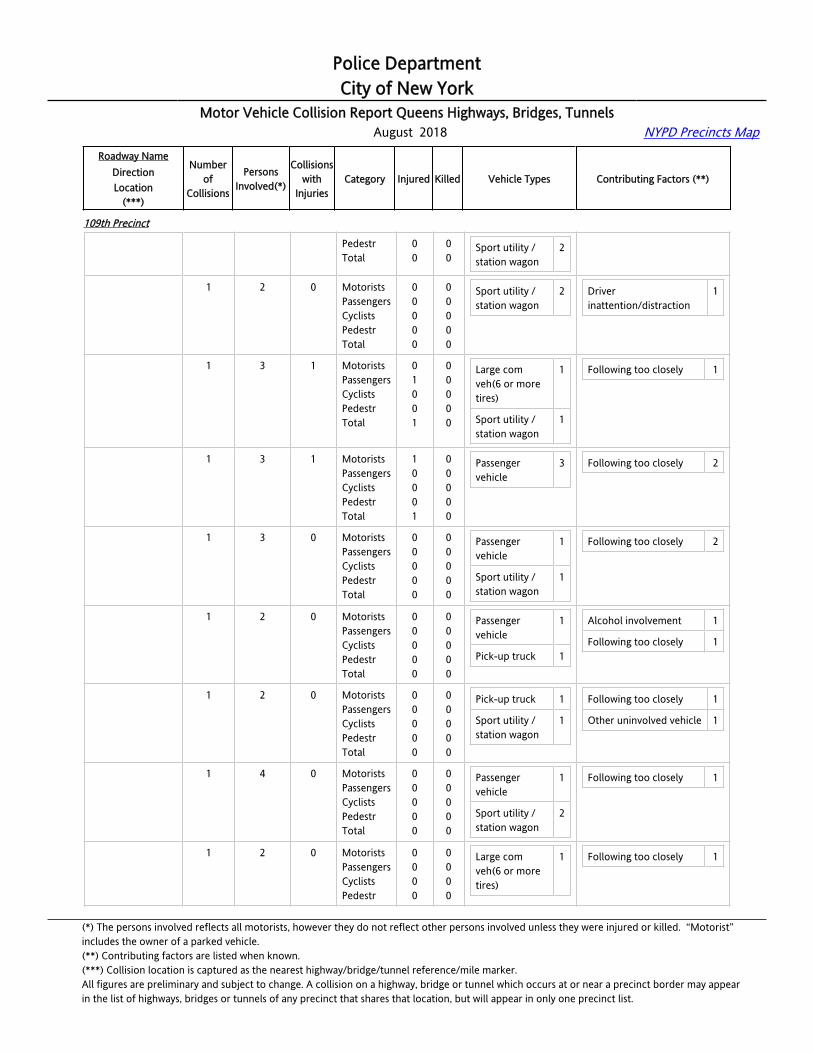
Police DepartmentCity of New York
Motor Vehicle Collision Report Queens Highways, Bridges, Tunnels August 2018 NYPD Precincts Map
Roadway NameDirectionLocation
(***)
Numberof
Collisions
PersonsInvolved(*)
Collisionswith
InjuriesCategory Injured Killed Vehicle Types Contributing Factors (**)
109th Precinct
QNS SIDE PedestrTotal
00
00
Sport utility / station wagon
2
Bridge : BX WHTSTN BRSB@QNS SIDE
1 2 0 MotoristsPassengersCyclistsPedestrTotal
00000
00000
Sport utility / station wagon
2 Driver inattention/distraction
1
Bridge : BX WHTSTN BRSB@QNS SIDE
1 3 1 MotoristsPassengersCyclistsPedestrTotal
01001
00000
Large com veh(6 or more tires)
1
Sport utility / station wagon
1
Following too closely 1
Bridge : BX WHTSTN BRSB@QNS SIDE
1 3 1 MotoristsPassengersCyclistsPedestrTotal
10001
00000
Passenger vehicle
3 Following too closely 2
Bridge : BX WHTSTN BRSB@QNS SIDE
1 3 0 MotoristsPassengersCyclistsPedestrTotal
00000
00000
Passenger vehicle
1
Sport utility / station wagon
1
Following too closely 2
Bridge : BX WHTSTN BRSB@QNS SIDE
1 2 0 MotoristsPassengersCyclistsPedestrTotal
00000
00000
Passenger vehicle
1
Pick-up truck 1
Alcohol involvement 1
Following too closely 1
Bridge : BX WHTSTN BRSB@QNS SIDE
1 2 0 MotoristsPassengersCyclistsPedestrTotal
00000
00000
Pick-up truck 1
Sport utility / station wagon
1
Following too closely 1
Other uninvolved vehicle 1
Bridge : BX WHTSTN BRSB@QNS SIDE
1 4 0 MotoristsPassengersCyclistsPedestrTotal
00000
00000
Passenger vehicle
1
Sport utility / station wagon
2
Following too closely 1
Bridge : BX WHTSTN BRSB@QNS SIDE
1 2 0 MotoristsPassengersCyclistsPedestr
0000
0000
Large com veh(6 or more tires)
1 Following too closely 1
(*) The persons involved reflects all motorists, however they do not reflect other persons involved unless they were injured or killed. “Motorist” includes the owner of a parked vehicle.(**) Contributing factors are listed when known.(***) Collision location is captured as the nearest highway/bridge/tunnel reference/mile marker.All figures are preliminary and subject to change. A collision on a highway, bridge or tunnel which occurs at or near a precinct border may appearin the list of highways, bridges or tunnels of any precinct that shares that location, but will appear in only one precinct list.
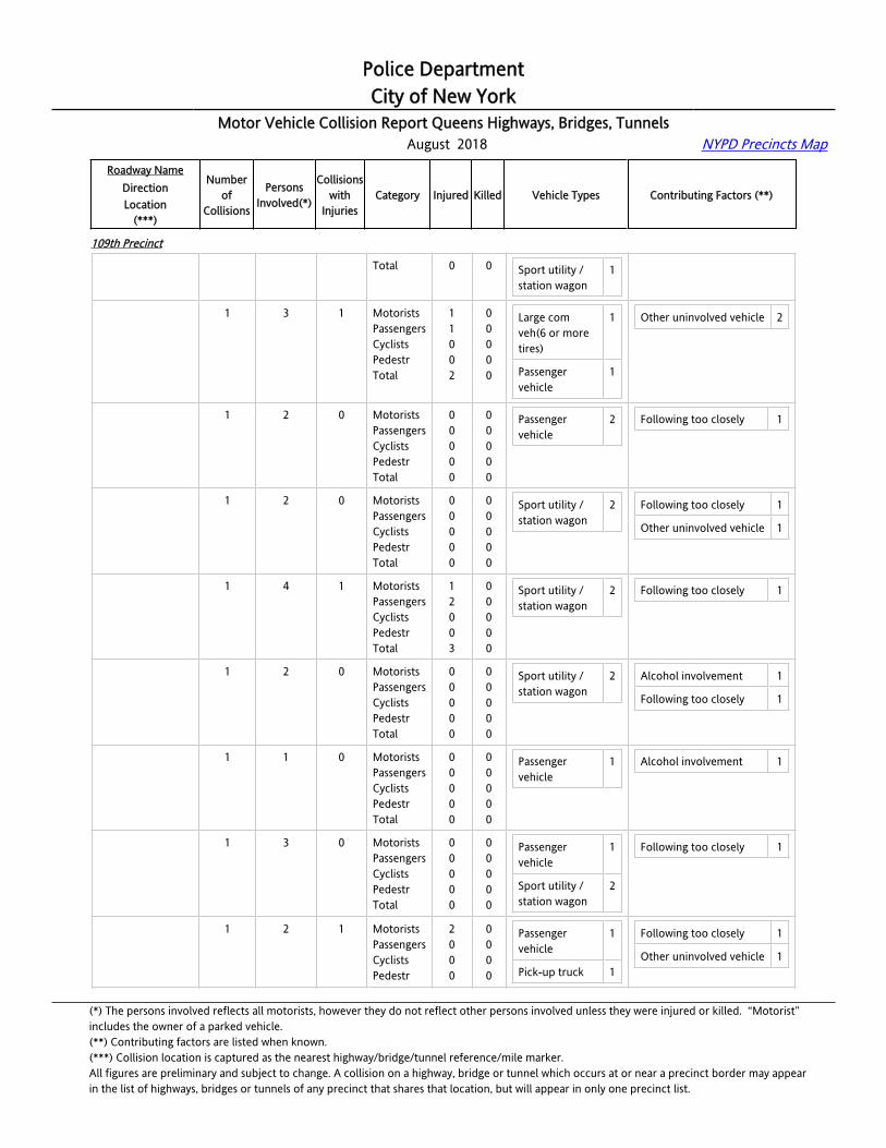
Police DepartmentCity of New York
Motor Vehicle Collision Report Queens Highways, Bridges, Tunnels August 2018 NYPD Precincts Map
Roadway NameDirectionLocation
(***)
Numberof
Collisions
PersonsInvolved(*)
Collisionswith
InjuriesCategory Injured Killed Vehicle Types Contributing Factors (**)
109th Precinct
Total 0 0 Sport utility / station wagon
1
Bridge : BX WHTSTN BRSB@QNS SIDE
1 3 1 MotoristsPassengersCyclistsPedestrTotal
11002
00000
Large com veh(6 or more tires)
1
Passenger vehicle
1
Other uninvolved vehicle 2
Bridge : BX WHTSTN BRSB@QNS SIDE
1 2 0 MotoristsPassengersCyclistsPedestrTotal
00000
00000
Passenger vehicle
2 Following too closely 1
Bridge : BX WHTSTN BRSB@QNS SIDE
1 2 0 MotoristsPassengersCyclistsPedestrTotal
00000
00000
Sport utility / station wagon
2 Following too closely 1
Other uninvolved vehicle 1
Bridge : BX WHTSTN BRSB@QNS SIDE
1 4 1 MotoristsPassengersCyclistsPedestrTotal
12003
00000
Sport utility / station wagon
2 Following too closely 1
Bridge : BX WHTSTN BRSB@QNS SIDE
1 2 0 MotoristsPassengersCyclistsPedestrTotal
00000
00000
Sport utility / station wagon
2 Alcohol involvement 1
Following too closely 1
Bridge : BX WHTSTN BRSB@QNS SIDE
1 1 0 MotoristsPassengersCyclistsPedestrTotal
00000
00000
Passenger vehicle
1 Alcohol involvement 1
Bridge : BX WHTSTN BRSB@QNS SIDE
1 3 0 MotoristsPassengersCyclistsPedestrTotal
00000
00000
Passenger vehicle
1
Sport utility / station wagon
2
Following too closely 1
Bridge : BX WHTSTN BRSB@QNS SIDE
1 2 1 MotoristsPassengersCyclistsPedestr
2000
0000
Passenger vehicle
1
Pick-up truck 1
Following too closely 1
Other uninvolved vehicle 1
(*) The persons involved reflects all motorists, however they do not reflect other persons involved unless they were injured or killed. “Motorist” includes the owner of a parked vehicle.(**) Contributing factors are listed when known.(***) Collision location is captured as the nearest highway/bridge/tunnel reference/mile marker.All figures are preliminary and subject to change. A collision on a highway, bridge or tunnel which occurs at or near a precinct border may appearin the list of highways, bridges or tunnels of any precinct that shares that location, but will appear in only one precinct list.
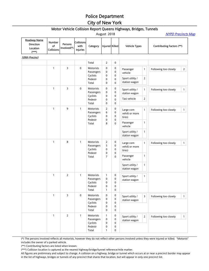
Police DepartmentCity of New York
Motor Vehicle Collision Report Queens Highways, Bridges, Tunnels August 2018 NYPD Precincts Map
Roadway NameDirectionLocation
(***)
Numberof
Collisions
PersonsInvolved(*)
Collisionswith
InjuriesCategory Injured Killed Vehicle Types Contributing Factors (**)
109th Precinct
Total 2 0
Bridge : BX WHTSTN BRSB@QNS SIDE
1 3 0 MotoristsPassengersCyclistsPedestrTotal
00000
00000
Passenger vehicle
1
Sport utility / station wagon
2
Following too closely 2
Bridge : BX WHTSTN BRSB@QNS SIDE
1 3 0 MotoristsPassengersCyclistsPedestrTotal
00000
00000
Sport utility / station wagon
1
Taxi vehicle 2
Following too closely 1
Bridge : BX WHTSTN BRSB@QNS SIDE
1 9 1 MotoristsPassengersCyclistsPedestrTotal
26008
00000
Large com veh(6 or more tires)
1
Passenger vehicle
1
Sport utility / station wagon
1
Following too closely 1
Bridge : BX WHTSTN BRSB@QNS SIDE
1 8 1 MotoristsPassengersCyclistsPedestrTotal
25007
00000
Large com veh(6 or more tires)
1
Passenger vehicle
1
Sport utility / station wagon
1
Following too closely 1
Bridge : BX WHTSTN BRSB@QNS SIDE
1 2 1 MotoristsPassengersCyclistsPedestrTotal
10001
00000
Sport utility / station wagon
1
Bridge : BX WHTSTN BRSB@QNS SIDE
1 3 0 MotoristsPassengersCyclistsPedestrTotal
00000
00000
Sport utility / station wagon
3 Following too closely 1
Bridge : BX WHTSTN BRSB@QNS SIDE
1 2 1 MotoristsPassengersCyclistsPedestrTotal
10001
00000
Sport utility / station wagon
2 Following too closely 1
(*) The persons involved reflects all motorists, however they do not reflect other persons involved unless they were injured or killed. “Motorist” includes the owner of a parked vehicle.(**) Contributing factors are listed when known.(***) Collision location is captured as the nearest highway/bridge/tunnel reference/mile marker.All figures are preliminary and subject to change. A collision on a highway, bridge or tunnel which occurs at or near a precinct border may appearin the list of highways, bridges or tunnels of any precinct that shares that location, but will appear in only one precinct list.

Police DepartmentCity of New York
Motor Vehicle Collision Report Queens Highways, Bridges, Tunnels August 2018 NYPD Precincts Map
Roadway NameDirectionLocation
(***)
Numberof
Collisions
PersonsInvolved(*)
Collisionswith
InjuriesCategory Injured Killed Vehicle Types Contributing Factors (**)
109th Precinct
Bridge : BX WHTSTN BRSB@QNS SIDE
1 3 0 MotoristsPassengersCyclistsPedestrTotal
00000
00000
Passenger vehicle
1
Sport utility / station wagon
1
Following too closely 1
Bridge : BX WHTSTN BRSB@QNS SIDE
1 4 0 MotoristsPassengersCyclistsPedestrTotal
00000
00000
Passenger vehicle
1
Sport utility / station wagon
3
Bridge : BX WHTSTN BRSB@QNS SIDE
1 3 1 MotoristsPassengersCyclistsPedestrTotal
10001
00000
Passenger vehicle
2
Bridge : BX WHTSTN BRSB@QNS SIDE
1 2 0 MotoristsPassengersCyclistsPedestrTotal
00000
00000
Sport utility / station wagon
2 Following too closely 1
Bridge : BX WHTSTN BRSB@QNS SIDE
1 4 1 MotoristsPassengersCyclistsPedestrTotal
12003
00000
Sport utility / station wagon
1
Taxi vehicle 1
Following too closely 1
Highway :CLEARVIEW EXPNB@CROSS ISLAND PKY
1 2 0 MotoristsPassengersCyclistsPedestrTotal
00000
00000
Passenger vehicle
1
Pick-up truck 1
Following too closely 1
Highway :CLEARVIEW EXPSB@CROSS ISLAND PKY
1 2 0 MotoristsPassengersCyclistsPedestrTotal
00000
00000
Large com veh(6 or more tires)
2 Driver inattention/distraction
1
Highway :CROSS ISLAND [email protected] N CLINTONVILLE ST
1 2 0 MotoristsPassengersCyclistsPedestrTotal
00000
00000
Sport utility / station wagon
2 Following too closely 1
Highway :CROSS ISLAND PKY
1 2 0 MotoristsPassengers
00
00
Passenger vehicle
1 Following too closely 1
(*) The persons involved reflects all motorists, however they do not reflect other persons involved unless they were injured or killed. “Motorist” includes the owner of a parked vehicle.(**) Contributing factors are listed when known.(***) Collision location is captured as the nearest highway/bridge/tunnel reference/mile marker.All figures are preliminary and subject to change. A collision on a highway, bridge or tunnel which occurs at or near a precinct border may appearin the list of highways, bridges or tunnels of any precinct that shares that location, but will appear in only one precinct list.

Police DepartmentCity of New York
Motor Vehicle Collision Report Queens Highways, Bridges, Tunnels August 2018 NYPD Precincts Map
Roadway NameDirectionLocation
(***)
Numberof
Collisions
PersonsInvolved(*)
Collisionswith
InjuriesCategory Injured Killed Vehicle Types Contributing Factors (**)
109th Precinct
[email protected] N/O 24 AV
CyclistsPedestrTotal
000
000
Taxi vehicle 1
Highway :CROSS ISLAND [email protected] S THROGS NECK BR
1 3 1 MotoristsPassengersCyclistsPedestrTotal
10001
00000
Passenger vehicle
2
Sport utility / station wagon
1
Following too closely 1
Highway :CROSS ISLAND PKYNB@160 ST
1 2 1 MotoristsPassengersCyclistsPedestrTotal
10001
00000
Passenger vehicle
1
Sport utility / station wagon
1
Following too closely 1
Highway :CROSS ISLAND PKYNB@24 AV
1 2 0 MotoristsPassengersCyclistsPedestrTotal
00000
00000
Sport utility / station wagon
2 Following too closely 1
Highway :CROSS ISLAND PKYNB@26 AV
1 2 1 MotoristsPassengersCyclistsPedestrTotal
10001
00000
Passenger vehicle
2 Following too closely 1
Highway :CROSS ISLAND PKYNB@RP TO 295 N/B EX
1 2 0 MotoristsPassengersCyclistsPedestrTotal
00000
00000
Sport utility / station wagon
2 Driver inattention/distraction
1
Highway :CROSS ISLAND [email protected] N/O BELL BL
1 2 0 MotoristsPassengersCyclistsPedestrTotal
00000
00000
Sport utility / station wagon
2 Unsafe lane changing 1
Highway :CROSS ISLAND [email protected] S THROGS NECK BR
2 4 0 MotoristsPassengersCyclistsPedestrTotal
00000
00000
Passenger vehicle
1
Sport utility / station wagon
3
Following too closely 2
Highway :CROSS ISLAND [email protected] S THROGS NECK BR
1 2 0 MotoristsPassengersCyclistsPedestr
0000
0000
Passenger vehicle
1
Sport utility / 1
Following too closely 1
(*) The persons involved reflects all motorists, however they do not reflect other persons involved unless they were injured or killed. “Motorist” includes the owner of a parked vehicle.(**) Contributing factors are listed when known.(***) Collision location is captured as the nearest highway/bridge/tunnel reference/mile marker.All figures are preliminary and subject to change. A collision on a highway, bridge or tunnel which occurs at or near a precinct border may appearin the list of highways, bridges or tunnels of any precinct that shares that location, but will appear in only one precinct list.

Police DepartmentCity of New York
Motor Vehicle Collision Report Queens Highways, Bridges, Tunnels August 2018 NYPD Precincts Map
Roadway NameDirectionLocation
(***)
Numberof
Collisions
PersonsInvolved(*)
Collisionswith
InjuriesCategory Injured Killed Vehicle Types Contributing Factors (**)
109th Precinct
Total 0 0 station wagon
Highway :CROSS ISLAND [email protected] S THROGS NECK BR
1 2 0 MotoristsPassengersCyclistsPedestrTotal
00000
00000
Sport utility / station wagon
2 Following too closely 1
Highway :CROSS ISLAND [email protected] S/O BELL BL
1 2 0 MotoristsPassengersCyclistsPedestrTotal
00000
00000
Passenger vehicle
2 Following too closely 1
Highway :CROSS ISLAND [email protected] S/O UTOPIA PKY
1 2 0 MotoristsPassengersCyclistsPedestrTotal
00000
00000
Passenger vehicle
1
Sport utility / station wagon
1
Following too closely 1
Highway :CROSS ISLAND PKYSB@149 ST
1 2 1 MotoristsPassengersCyclistsPedestrTotal
10001
00000
Passenger vehicle
2
Highway :CROSS ISLAND PKYSB@24 AV
2 4 0 MotoristsPassengersCyclistsPedestrTotal
00000
00000
Passenger vehicle
1
Pick-up truck 1
Sport utility / station wagon
2
Fell asleep 1
Unsafe speed 1
Highway :CROSS ISLAND PKYSB@24 AV
1 2 0 MotoristsPassengersCyclistsPedestrTotal
00000
00000
Passenger vehicle
1
Sport utility / station wagon
1
Unsafe speed 1
Highway :CROSS ISLAND PKYSB@24 AV
1 2 0 MotoristsPassengersCyclistsPedestrTotal
00000
00000
Pick-up truck 1
Sport utility / station wagon
1
Fell asleep 1
Highway :CROSS ISLAND PKYSB@FRANCIS LEWIS BL
2 4 2 MotoristsPassengersCyclistsPedestr
2000
0000
Passenger vehicle
1
Sport utility / 3
Driver inattention/distraction
1
Following too closely 1
(*) The persons involved reflects all motorists, however they do not reflect other persons involved unless they were injured or killed. “Motorist” includes the owner of a parked vehicle.(**) Contributing factors are listed when known.(***) Collision location is captured as the nearest highway/bridge/tunnel reference/mile marker.All figures are preliminary and subject to change. A collision on a highway, bridge or tunnel which occurs at or near a precinct border may appearin the list of highways, bridges or tunnels of any precinct that shares that location, but will appear in only one precinct list.

Police DepartmentCity of New York
Motor Vehicle Collision Report Queens Highways, Bridges, Tunnels August 2018 NYPD Precincts Map
Roadway NameDirectionLocation
(***)
Numberof
Collisions
PersonsInvolved(*)
Collisionswith
InjuriesCategory Injured Killed Vehicle Types Contributing Factors (**)
109th Precinct
Total 2 0 station wagon
Highway :CROSS ISLAND PKYSB@FRANCIS LEWIS BL
1 2 1 MotoristsPassengersCyclistsPedestrTotal
10001
00000
Sport utility / station wagon
2 Driver inattention/distraction
1
Highway :CROSS ISLAND PKYSB@FRANCIS LEWIS BL
1 2 1 MotoristsPassengersCyclistsPedestrTotal
10001
00000
Passenger vehicle
1
Sport utility / station wagon
1
Following too closely 1
Highway :CROSS ISLAND PKYSB@THROGS NECK BR
1 2 0 MotoristsPassengersCyclistsPedestrTotal
00000
00000
Sport utility / station wagon
2 Driver inattention/distraction
1
Highway :CROSS ISLAND PKYSB@UTOPIA PKY EX
1 2 0 MotoristsPassengersCyclistsPedestrTotal
00000
00000
Passenger vehicle
2 Following too closely 1
Highway :[email protected] E/O VAN WYCK EXP
1 2 0 MotoristsPassengersCyclistsPedestrTotal
00000
00000
Large com veh(6 or more tires)
1
Passenger vehicle
1
Failure to yield right-of-way
1
Highway :[email protected] E/O VAN WYCK EXP
2 4 0 MotoristsPassengersCyclistsPedestrTotal
00000
00000
Passenger vehicle
2
Sport utility / station wagon
2
Following too closely 2
Highway :[email protected] E/O VAN WYCK EXP
1 2 0 MotoristsPassengersCyclistsPedestrTotal
00000
00000
Passenger vehicle
1
Sport utility / station wagon
1
Following too closely 1
Highway :[email protected] E/O VAN WYCK EXP
1 2 0 MotoristsPassengersCyclistsPedestrTotal
00000
00000
Passenger vehicle
1
Sport utility / station wagon
1
Following too closely 1
(*) The persons involved reflects all motorists, however they do not reflect other persons involved unless they were injured or killed. “Motorist” includes the owner of a parked vehicle.(**) Contributing factors are listed when known.(***) Collision location is captured as the nearest highway/bridge/tunnel reference/mile marker.All figures are preliminary and subject to change. A collision on a highway, bridge or tunnel which occurs at or near a precinct border may appearin the list of highways, bridges or tunnels of any precinct that shares that location, but will appear in only one precinct list.

Police DepartmentCity of New York
Motor Vehicle Collision Report Queens Highways, Bridges, Tunnels August 2018 NYPD Precincts Map
Roadway NameDirectionLocation
(***)
Numberof
Collisions
PersonsInvolved(*)
Collisionswith
InjuriesCategory Injured Killed Vehicle Types Contributing Factors (**)
109th Precinct
Highway :[email protected] E/O VAN WYCK EXP
2 8 1 MotoristsPassengersCyclistsPedestrTotal
12003
00000
Passenger vehicle
2
Pick-up truck 1
Sport utility / station wagon
3
Failure to yield right-of-way
1
Following too closely 1
Highway :[email protected] E/O VAN WYCK EXP
1 3 0 MotoristsPassengersCyclistsPedestrTotal
00000
00000
Passenger vehicle
1
Pick-up truck 1
Sport utility / station wagon
1
Following too closely 1
Highway :[email protected] E/O VAN WYCK EXP
1 5 1 MotoristsPassengersCyclistsPedestrTotal
12003
00000
Passenger vehicle
1
Sport utility / station wagon
2
Failure to yield right-of-way
1
Highway :L.I.E.WB@138 ST
1 2 0 MotoristsPassengersCyclistsPedestrTotal
00000
00000
Passenger vehicle
1
Sport utility / station wagon
1
Passing or lane usage improper
1
Highway :L.I.E.WB@160 ST
1 3 1 MotoristsPassengersCyclistsPedestrTotal
10001
00000
Large com veh(6 or more tires)
1
Passenger vehicle
2
Following too closely 1
Highway :L.I.E.WB@163 ST
1 2 1 MotoristsPassengersCyclistsPedestrTotal
01001
00000
Passenger vehicle
1 Other uninvolved vehicle 1
Highway :L.I.E.WB@164 ST
3 6 1 MotoristsPassengersCyclistsPedestrTotal
10001
00000
Passenger vehicle
2
Sport utility / station wagon
4
Driver inattention/distraction
1
Following too closely 2
Highway :L.I.E.WB@164 ST
1 2 0 MotoristsPassengersCyclistsPedestr
0000
0000
Sport utility / station wagon
2 Following too closely 1
(*) The persons involved reflects all motorists, however they do not reflect other persons involved unless they were injured or killed. “Motorist” includes the owner of a parked vehicle.(**) Contributing factors are listed when known.(***) Collision location is captured as the nearest highway/bridge/tunnel reference/mile marker.All figures are preliminary and subject to change. A collision on a highway, bridge or tunnel which occurs at or near a precinct border may appearin the list of highways, bridges or tunnels of any precinct that shares that location, but will appear in only one precinct list.
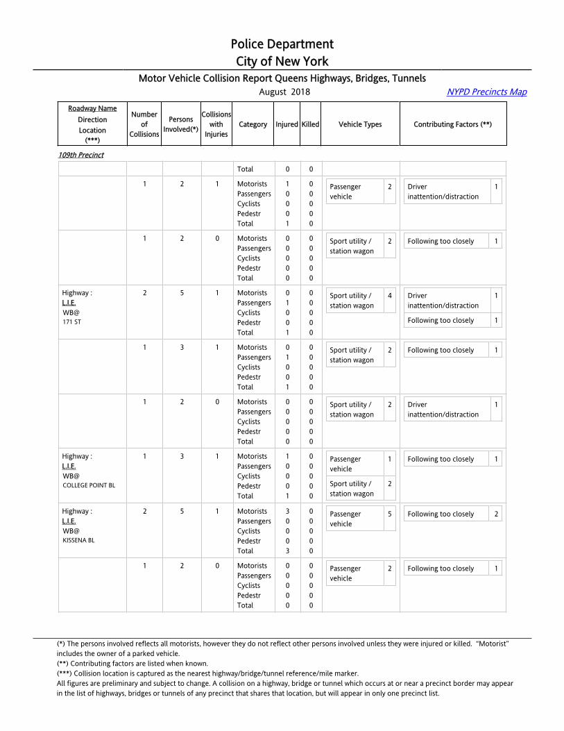
Police DepartmentCity of New York
Motor Vehicle Collision Report Queens Highways, Bridges, Tunnels August 2018 NYPD Precincts Map
Roadway NameDirectionLocation
(***)
Numberof
Collisions
PersonsInvolved(*)
Collisionswith
InjuriesCategory Injured Killed Vehicle Types Contributing Factors (**)
109th Precinct
Total 0 0
Highway :L.I.E.WB@164 ST
1 2 1 MotoristsPassengersCyclistsPedestrTotal
10001
00000
Passenger vehicle
2 Driver inattention/distraction
1
Highway :L.I.E.WB@164 ST
1 2 0 MotoristsPassengersCyclistsPedestrTotal
00000
00000
Sport utility / station wagon
2 Following too closely 1
Highway :L.I.E.WB@171 ST
2 5 1 MotoristsPassengersCyclistsPedestrTotal
01001
00000
Sport utility / station wagon
4 Driver inattention/distraction
1
Following too closely 1
Highway :L.I.E.WB@171 ST
1 3 1 MotoristsPassengersCyclistsPedestrTotal
01001
00000
Sport utility / station wagon
2 Following too closely 1
Highway :L.I.E.WB@171 ST
1 2 0 MotoristsPassengersCyclistsPedestrTotal
00000
00000
Sport utility / station wagon
2 Driver inattention/distraction
1
Highway :L.I.E.WB@COLLEGE POINT BL
1 3 1 MotoristsPassengersCyclistsPedestrTotal
10001
00000
Passenger vehicle
1
Sport utility / station wagon
2
Following too closely 1
Highway :L.I.E.WB@KISSENA BL
2 5 1 MotoristsPassengersCyclistsPedestrTotal
30003
00000
Passenger vehicle
5 Following too closely 2
Highway :L.I.E.WB@KISSENA BL
1 2 0 MotoristsPassengersCyclistsPedestrTotal
00000
00000
Passenger vehicle
2 Following too closely 1
(*) The persons involved reflects all motorists, however they do not reflect other persons involved unless they were injured or killed. “Motorist” includes the owner of a parked vehicle.(**) Contributing factors are listed when known.(***) Collision location is captured as the nearest highway/bridge/tunnel reference/mile marker.All figures are preliminary and subject to change. A collision on a highway, bridge or tunnel which occurs at or near a precinct border may appearin the list of highways, bridges or tunnels of any precinct that shares that location, but will appear in only one precinct list.

Police DepartmentCity of New York
Motor Vehicle Collision Report Queens Highways, Bridges, Tunnels August 2018 NYPD Precincts Map
Roadway NameDirectionLocation
(***)
Numberof
Collisions
PersonsInvolved(*)
Collisionswith
InjuriesCategory Injured Killed Vehicle Types Contributing Factors (**)
109th Precinct
Highway :L.I.E.WB@KISSENA BL
1 3 1 MotoristsPassengersCyclistsPedestrTotal
30003
00000
Passenger vehicle
3 Following too closely 1
Bridge : TNECK BRNB@QNS SIDE
1 2 0 MotoristsPassengersCyclistsPedestrTotal
00000
00000
Large com veh(6 or more tires)
1
Van 1
Following too closely 1
Bridge : TNECK BRSB@QNS SIDE
1 2 1 MotoristsPassengersCyclistsPedestrTotal
10001
00000
Passenger vehicle
1
Pick-up truck 1
Following too closely 1
Highway :WHITESTONE [email protected] N/O 14 AV
1 2 1 MotoristsPassengersCyclistsPedestrTotal
10001
00000
Pick-up truck 1
Sport utility / station wagon
1
Following too closely 1
Highway :WHITESTONE [email protected] N/O 20 AV
1 2 0 MotoristsPassengersCyclistsPedestrTotal
00000
00000
Passenger vehicle
1
Sport utility / station wagon
1
Following too closely 1
Highway :WHITESTONE [email protected] S/O 20 AV
1 2 0 MotoristsPassengersCyclistsPedestrTotal
00000
00000
Sport utility / station wagon
2 Other uninvolved vehicle 1
Highway :WHITESTONE EXPNB@1/8 N/O C.I.P.
2 6 0 MotoristsPassengersCyclistsPedestrTotal
00000
00000
Large com veh(6 or more tires)
1
Passenger vehicle
2
Pick-up truck 1
Sport utility / station wagon
2
Unsafe lane changing 1
Highway :WHITESTONE EXPNB@
1 4 0 MotoristsPassengersCyclists
000
000
Passenger vehicle
1
(*) The persons involved reflects all motorists, however they do not reflect other persons involved unless they were injured or killed. “Motorist” includes the owner of a parked vehicle.(**) Contributing factors are listed when known.(***) Collision location is captured as the nearest highway/bridge/tunnel reference/mile marker.All figures are preliminary and subject to change. A collision on a highway, bridge or tunnel which occurs at or near a precinct border may appearin the list of highways, bridges or tunnels of any precinct that shares that location, but will appear in only one precinct list.
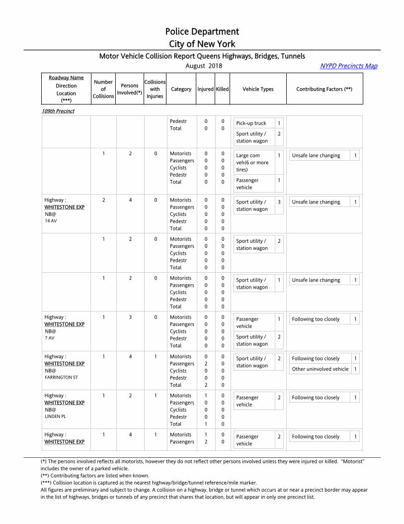
Police DepartmentCity of New York
Motor Vehicle Collision Report Queens Highways, Bridges, Tunnels August 2018 NYPD Precincts Map
Roadway NameDirectionLocation
(***)
Numberof
Collisions
PersonsInvolved(*)
Collisionswith
InjuriesCategory Injured Killed Vehicle Types Contributing Factors (**)
109th Precinct
1/8 N/O C.I.P. PedestrTotal
00
00
Pick-up truck 1
Sport utility / station wagon
2
Highway :WHITESTONE EXPNB@1/8 N/O C.I.P.
1 2 0 MotoristsPassengersCyclistsPedestrTotal
00000
00000
Large com veh(6 or more tires)
1
Passenger vehicle
1
Unsafe lane changing 1
Highway :WHITESTONE EXPNB@14 AV
2 4 0 MotoristsPassengersCyclistsPedestrTotal
00000
00000
Sport utility / station wagon
3 Unsafe lane changing 1
Highway :WHITESTONE EXPNB@14 AV
1 2 0 MotoristsPassengersCyclistsPedestrTotal
00000
00000
Sport utility / station wagon
2
Highway :WHITESTONE EXPNB@14 AV
1 2 0 MotoristsPassengersCyclistsPedestrTotal
00000
00000
Sport utility / station wagon
1 Unsafe lane changing 1
Highway :WHITESTONE EXPNB@7 AV
1 3 0 MotoristsPassengersCyclistsPedestrTotal
00000
00000
Passenger vehicle
1
Sport utility / station wagon
2
Following too closely 1
Highway :WHITESTONE EXPNB@FARRINGTON ST
1 4 1 MotoristsPassengersCyclistsPedestrTotal
02002
00000
Sport utility / station wagon
2 Following too closely 1
Other uninvolved vehicle 1
Highway :WHITESTONE EXPNB@LINDEN PL
1 2 1 MotoristsPassengersCyclistsPedestrTotal
10001
00000
Passenger vehicle
2 Following too closely 1
Highway :WHITESTONE EXP
1 4 1 MotoristsPassengers
12
00
Passenger vehicle
2 Following too closely 1
(*) The persons involved reflects all motorists, however they do not reflect other persons involved unless they were injured or killed. “Motorist” includes the owner of a parked vehicle.(**) Contributing factors are listed when known.(***) Collision location is captured as the nearest highway/bridge/tunnel reference/mile marker.All figures are preliminary and subject to change. A collision on a highway, bridge or tunnel which occurs at or near a precinct border may appearin the list of highways, bridges or tunnels of any precinct that shares that location, but will appear in only one precinct list.
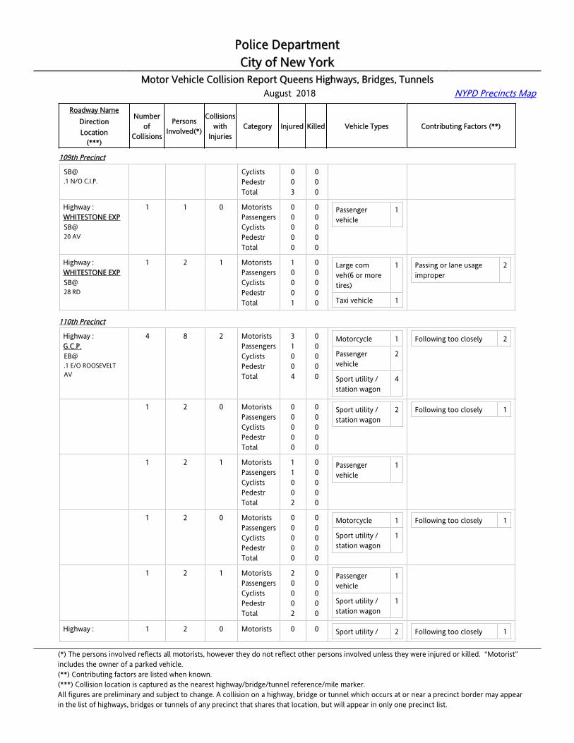
Police DepartmentCity of New York
Motor Vehicle Collision Report Queens Highways, Bridges, Tunnels August 2018 NYPD Precincts Map
Roadway NameDirectionLocation
(***)
Numberof
Collisions
PersonsInvolved(*)
Collisionswith
InjuriesCategory Injured Killed Vehicle Types Contributing Factors (**)
109th Precinct
[email protected] N/O C.I.P.
CyclistsPedestrTotal
003
000
Highway :WHITESTONE EXPSB@20 AV
1 1 0 MotoristsPassengersCyclistsPedestrTotal
00000
00000
Passenger vehicle
1
Highway :WHITESTONE EXPSB@28 RD
1 2 1 MotoristsPassengersCyclistsPedestrTotal
10001
00000
Large com veh(6 or more tires)
1
Taxi vehicle 1
Passing or lane usage improper
2
110th Precinct
Highway :[email protected] E/O ROOSEVELT AV
4 8 2 MotoristsPassengersCyclistsPedestrTotal
31004
00000
Motorcycle 1
Passenger vehicle
2
Sport utility / station wagon
4
Following too closely 2
Highway :[email protected] E/O ROOSEVELT AV
1 2 0 MotoristsPassengersCyclistsPedestrTotal
00000
00000
Sport utility / station wagon
2 Following too closely 1
Highway :[email protected] E/O ROOSEVELT AV
1 2 1 MotoristsPassengersCyclistsPedestrTotal
11002
00000
Passenger vehicle
1
Highway :[email protected] E/O ROOSEVELT AV
1 2 0 MotoristsPassengersCyclistsPedestrTotal
00000
00000
Motorcycle 1
Sport utility / station wagon
1
Following too closely 1
Highway :[email protected] E/O ROOSEVELT AV
1 2 1 MotoristsPassengersCyclistsPedestrTotal
20002
00000
Passenger vehicle
1
Sport utility / station wagon
1
Highway : 1 2 0 Motorists 0 0 Sport utility / 2 Following too closely 1
(*) The persons involved reflects all motorists, however they do not reflect other persons involved unless they were injured or killed. “Motorist” includes the owner of a parked vehicle.(**) Contributing factors are listed when known.(***) Collision location is captured as the nearest highway/bridge/tunnel reference/mile marker.All figures are preliminary and subject to change. A collision on a highway, bridge or tunnel which occurs at or near a precinct border may appearin the list of highways, bridges or tunnels of any precinct that shares that location, but will appear in only one precinct list.
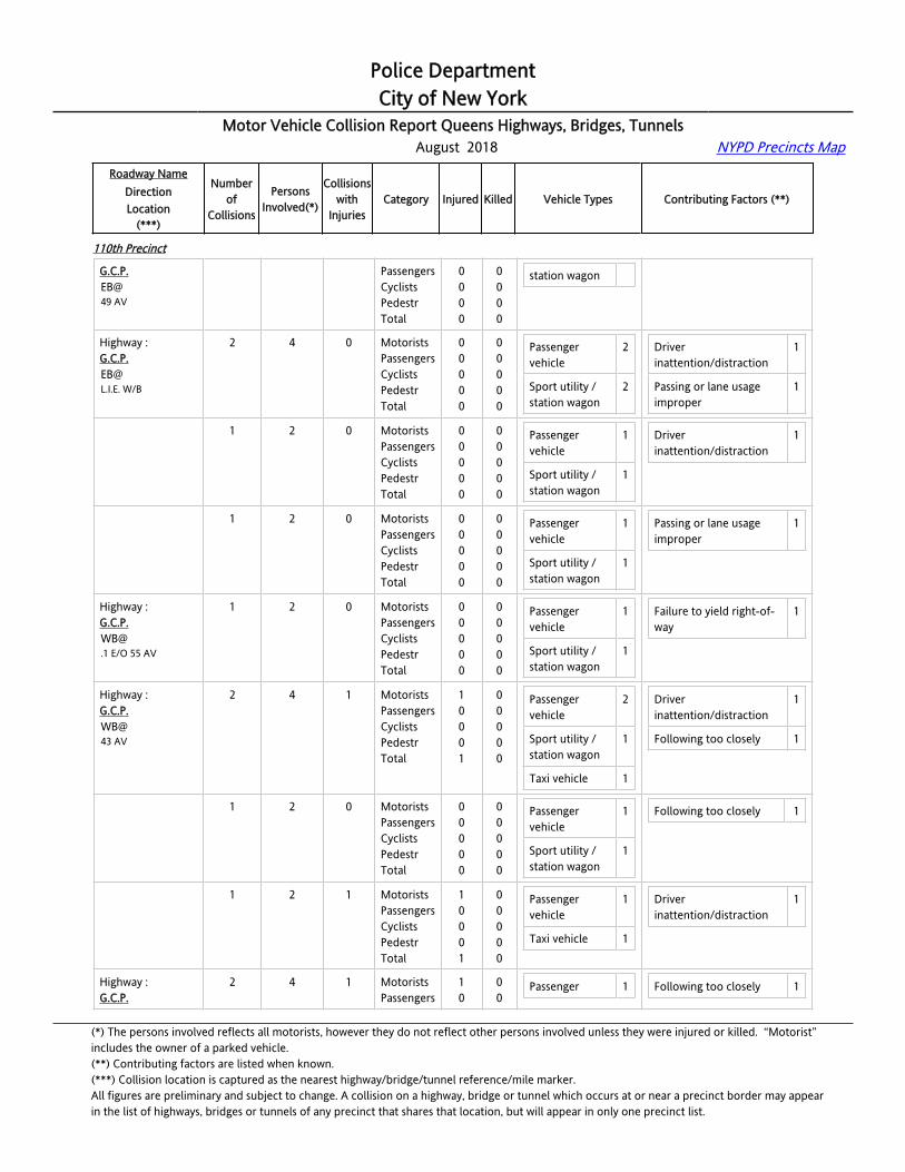
Police DepartmentCity of New York
Motor Vehicle Collision Report Queens Highways, Bridges, Tunnels August 2018 NYPD Precincts Map
Roadway NameDirectionLocation
(***)
Numberof
Collisions
PersonsInvolved(*)
Collisionswith
InjuriesCategory Injured Killed Vehicle Types Contributing Factors (**)
110th Precinct
G.C.P.EB@49 AV
PassengersCyclistsPedestrTotal
0000
0000
station wagon
Highway :[email protected]. W/B
2 4 0 MotoristsPassengersCyclistsPedestrTotal
00000
00000
Passenger vehicle
2
Sport utility / station wagon
2
Driver inattention/distraction
1
Passing or lane usage improper
1
Highway :[email protected]. W/B
1 2 0 MotoristsPassengersCyclistsPedestrTotal
00000
00000
Passenger vehicle
1
Sport utility / station wagon
1
Driver inattention/distraction
1
Highway :[email protected]. W/B
1 2 0 MotoristsPassengersCyclistsPedestrTotal
00000
00000
Passenger vehicle
1
Sport utility / station wagon
1
Passing or lane usage improper
1
Highway :[email protected] E/O 55 AV
1 2 0 MotoristsPassengersCyclistsPedestrTotal
00000
00000
Passenger vehicle
1
Sport utility / station wagon
1
Failure to yield right-of-way
1
Highway :G.C.P.WB@43 AV
2 4 1 MotoristsPassengersCyclistsPedestrTotal
10001
00000
Passenger vehicle
2
Sport utility / station wagon
1
Taxi vehicle 1
Driver inattention/distraction
1
Following too closely 1
Highway :G.C.P.WB@43 AV
1 2 0 MotoristsPassengersCyclistsPedestrTotal
00000
00000
Passenger vehicle
1
Sport utility / station wagon
1
Following too closely 1
Highway :G.C.P.WB@43 AV
1 2 1 MotoristsPassengersCyclistsPedestrTotal
10001
00000
Passenger vehicle
1
Taxi vehicle 1
Driver inattention/distraction
1
Highway :G.C.P.
2 4 1 MotoristsPassengers
10
00
Passenger 1 Following too closely 1
(*) The persons involved reflects all motorists, however they do not reflect other persons involved unless they were injured or killed. “Motorist” includes the owner of a parked vehicle.(**) Contributing factors are listed when known.(***) Collision location is captured as the nearest highway/bridge/tunnel reference/mile marker.All figures are preliminary and subject to change. A collision on a highway, bridge or tunnel which occurs at or near a precinct border may appearin the list of highways, bridges or tunnels of any precinct that shares that location, but will appear in only one precinct list.
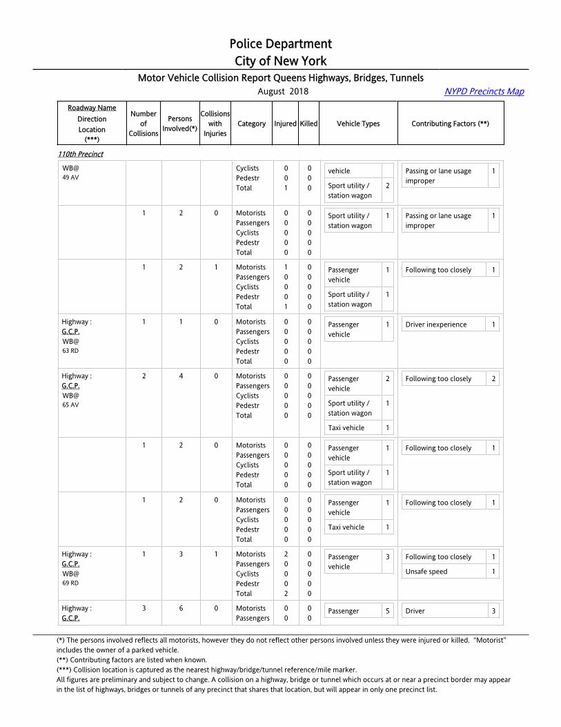
Police DepartmentCity of New York
Motor Vehicle Collision Report Queens Highways, Bridges, Tunnels August 2018 NYPD Precincts Map
Roadway NameDirectionLocation
(***)
Numberof
Collisions
PersonsInvolved(*)
Collisionswith
InjuriesCategory Injured Killed Vehicle Types Contributing Factors (**)
110th Precinct
WB@49 AV
CyclistsPedestrTotal
001
000
vehicle
Sport utility / station wagon
2
Passing or lane usage improper
1
Highway :G.C.P.WB@49 AV
1 2 0 MotoristsPassengersCyclistsPedestrTotal
00000
00000
Sport utility / station wagon
1 Passing or lane usage improper
1
Highway :G.C.P.WB@49 AV
1 2 1 MotoristsPassengersCyclistsPedestrTotal
10001
00000
Passenger vehicle
1
Sport utility / station wagon
1
Following too closely 1
Highway :G.C.P.WB@63 RD
1 1 0 MotoristsPassengersCyclistsPedestrTotal
00000
00000
Passenger vehicle
1 Driver inexperience 1
Highway :G.C.P.WB@65 AV
2 4 0 MotoristsPassengersCyclistsPedestrTotal
00000
00000
Passenger vehicle
2
Sport utility / station wagon
1
Taxi vehicle 1
Following too closely 2
Highway :G.C.P.WB@65 AV
1 2 0 MotoristsPassengersCyclistsPedestrTotal
00000
00000
Passenger vehicle
1
Sport utility / station wagon
1
Following too closely 1
Highway :G.C.P.WB@65 AV
1 2 0 MotoristsPassengersCyclistsPedestrTotal
00000
00000
Passenger vehicle
1
Taxi vehicle 1
Following too closely 1
Highway :G.C.P.WB@69 RD
1 3 1 MotoristsPassengersCyclistsPedestrTotal
20002
00000
Passenger vehicle
3 Following too closely 1
Unsafe speed 1
Highway :G.C.P.
3 6 0 MotoristsPassengers
00
00
Passenger 5 Driver 3
(*) The persons involved reflects all motorists, however they do not reflect other persons involved unless they were injured or killed. “Motorist” includes the owner of a parked vehicle.(**) Contributing factors are listed when known.(***) Collision location is captured as the nearest highway/bridge/tunnel reference/mile marker.All figures are preliminary and subject to change. A collision on a highway, bridge or tunnel which occurs at or near a precinct border may appearin the list of highways, bridges or tunnels of any precinct that shares that location, but will appear in only one precinct list.
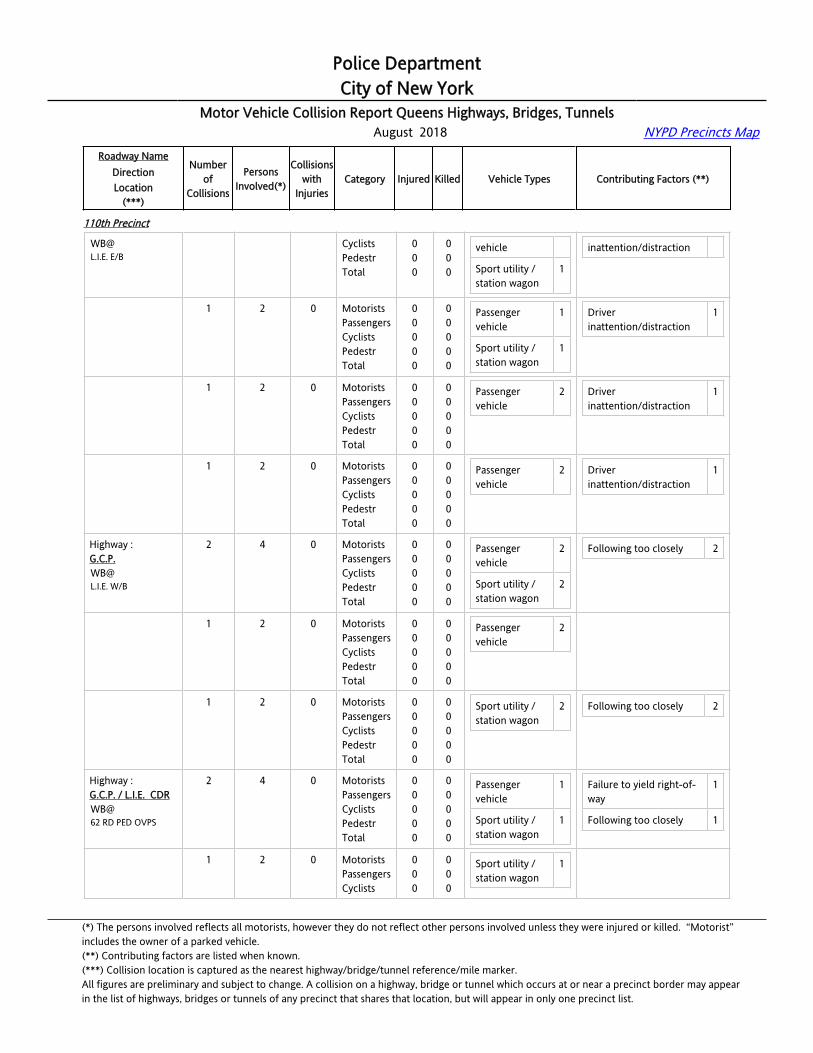
Police DepartmentCity of New York
Motor Vehicle Collision Report Queens Highways, Bridges, Tunnels August 2018 NYPD Precincts Map
Roadway NameDirectionLocation
(***)
Numberof
Collisions
PersonsInvolved(*)
Collisionswith
InjuriesCategory Injured Killed Vehicle Types Contributing Factors (**)
110th Precinct
[email protected]. E/B
CyclistsPedestrTotal
000
000
vehicle
Sport utility / station wagon
1
inattention/distraction
Highway :[email protected]. E/B
1 2 0 MotoristsPassengersCyclistsPedestrTotal
00000
00000
Passenger vehicle
1
Sport utility / station wagon
1
Driver inattention/distraction
1
Highway :[email protected]. E/B
1 2 0 MotoristsPassengersCyclistsPedestrTotal
00000
00000
Passenger vehicle
2 Driver inattention/distraction
1
Highway :[email protected]. E/B
1 2 0 MotoristsPassengersCyclistsPedestrTotal
00000
00000
Passenger vehicle
2 Driver inattention/distraction
1
Highway :[email protected]. W/B
2 4 0 MotoristsPassengersCyclistsPedestrTotal
00000
00000
Passenger vehicle
2
Sport utility / station wagon
2
Following too closely 2
Highway :[email protected]. W/B
1 2 0 MotoristsPassengersCyclistsPedestrTotal
00000
00000
Passenger vehicle
2
Highway :[email protected]. W/B
1 2 0 MotoristsPassengersCyclistsPedestrTotal
00000
00000
Sport utility / station wagon
2 Following too closely 2
Highway :G.C.P. / L.I.E. CDRWB@62 RD PED OVPS
2 4 0 MotoristsPassengersCyclistsPedestrTotal
00000
00000
Passenger vehicle
1
Sport utility / station wagon
1
Failure to yield right-of-way
1
Following too closely 1
Highway :G.C.P. / L.I.E. CDRWB@
1 2 0 MotoristsPassengersCyclists
000
000
Sport utility / station wagon
1
(*) The persons involved reflects all motorists, however they do not reflect other persons involved unless they were injured or killed. “Motorist” includes the owner of a parked vehicle.(**) Contributing factors are listed when known.(***) Collision location is captured as the nearest highway/bridge/tunnel reference/mile marker.All figures are preliminary and subject to change. A collision on a highway, bridge or tunnel which occurs at or near a precinct border may appearin the list of highways, bridges or tunnels of any precinct that shares that location, but will appear in only one precinct list.
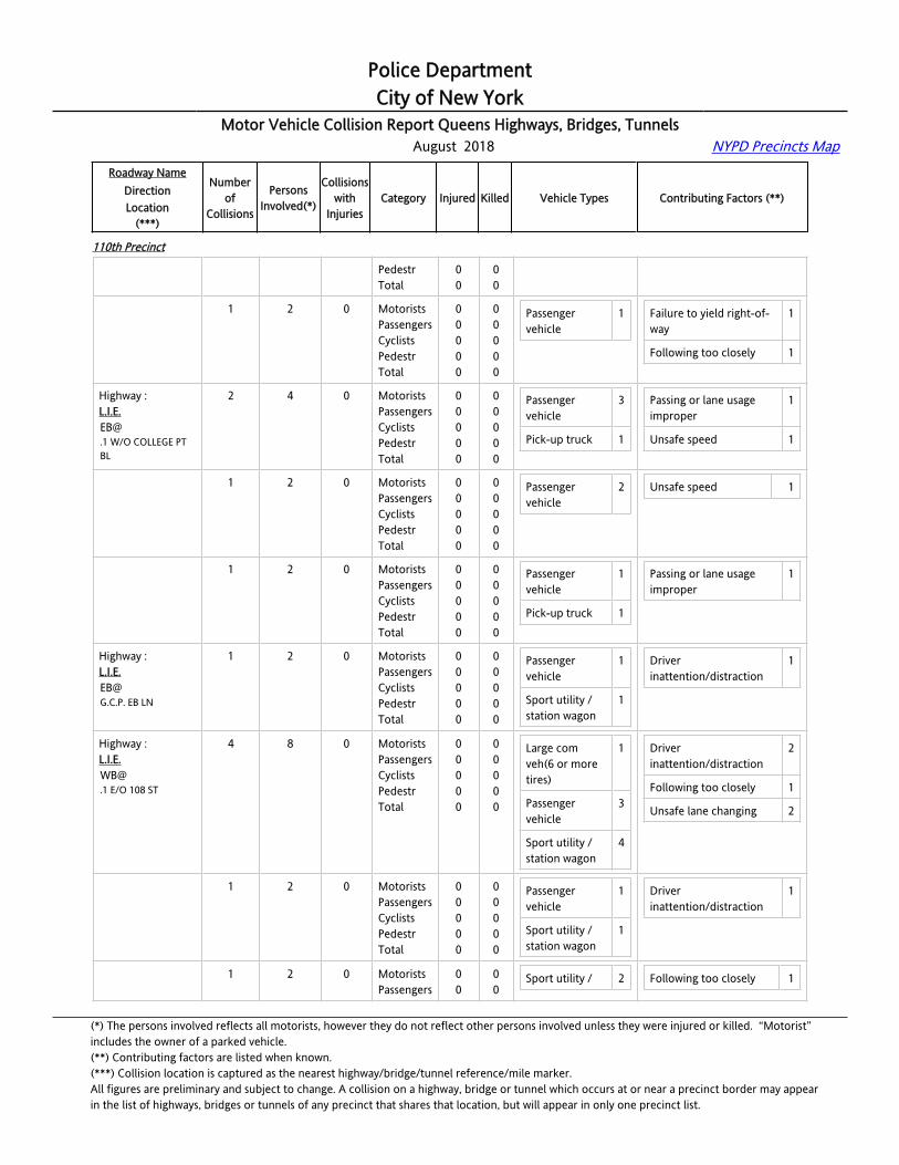
Police DepartmentCity of New York
Motor Vehicle Collision Report Queens Highways, Bridges, Tunnels August 2018 NYPD Precincts Map
Roadway NameDirectionLocation
(***)
Numberof
Collisions
PersonsInvolved(*)
Collisionswith
InjuriesCategory Injured Killed Vehicle Types Contributing Factors (**)
110th Precinct
62 RD PED OVPS PedestrTotal
00
00
Highway :G.C.P. / L.I.E. CDRWB@62 RD PED OVPS
1 2 0 MotoristsPassengersCyclistsPedestrTotal
00000
00000
Passenger vehicle
1 Failure to yield right-of-way
1
Following too closely 1
Highway :[email protected] W/O COLLEGE PT BL
2 4 0 MotoristsPassengersCyclistsPedestrTotal
00000
00000
Passenger vehicle
3
Pick-up truck 1
Passing or lane usage improper
1
Unsafe speed 1
Highway :[email protected] W/O COLLEGE PT BL
1 2 0 MotoristsPassengersCyclistsPedestrTotal
00000
00000
Passenger vehicle
2 Unsafe speed 1
Highway :[email protected] W/O COLLEGE PT BL
1 2 0 MotoristsPassengersCyclistsPedestrTotal
00000
00000
Passenger vehicle
1
Pick-up truck 1
Passing or lane usage improper
1
Highway :[email protected]. EB LN
1 2 0 MotoristsPassengersCyclistsPedestrTotal
00000
00000
Passenger vehicle
1
Sport utility / station wagon
1
Driver inattention/distraction
1
Highway :[email protected] E/O 108 ST
4 8 0 MotoristsPassengersCyclistsPedestrTotal
00000
00000
Large com veh(6 or more tires)
1
Passenger vehicle
3
Sport utility / station wagon
4
Driver inattention/distraction
2
Following too closely 1
Unsafe lane changing 2
Highway :[email protected] E/O 108 ST
1 2 0 MotoristsPassengersCyclistsPedestrTotal
00000
00000
Passenger vehicle
1
Sport utility / station wagon
1
Driver inattention/distraction
1
Highway :L.I.E.
1 2 0 MotoristsPassengers
00
00
Sport utility / 2 Following too closely 1
(*) The persons involved reflects all motorists, however they do not reflect other persons involved unless they were injured or killed. “Motorist” includes the owner of a parked vehicle.(**) Contributing factors are listed when known.(***) Collision location is captured as the nearest highway/bridge/tunnel reference/mile marker.All figures are preliminary and subject to change. A collision on a highway, bridge or tunnel which occurs at or near a precinct border may appearin the list of highways, bridges or tunnels of any precinct that shares that location, but will appear in only one precinct list.

Police DepartmentCity of New York
Motor Vehicle Collision Report Queens Highways, Bridges, Tunnels August 2018 NYPD Precincts Map
Roadway NameDirectionLocation
(***)
Numberof
Collisions
PersonsInvolved(*)
Collisionswith
InjuriesCategory Injured Killed Vehicle Types Contributing Factors (**)
110th Precinct
[email protected] E/O 108 ST
CyclistsPedestrTotal
000
000
station wagon
Highway :[email protected] E/O 108 ST
1 2 0 MotoristsPassengersCyclistsPedestrTotal
00000
00000
Passenger vehicle
1
Sport utility / station wagon
1
Driver inattention/distraction
1
Highway :[email protected] E/O 108 ST
1 2 0 MotoristsPassengersCyclistsPedestrTotal
00000
00000
Large com veh(6 or more tires)
1
Passenger vehicle
1
Unsafe lane changing 2
Highway :[email protected] E/O G.C.P.
4 9 1 MotoristsPassengersCyclistsPedestrTotal
01001
00000
Passenger vehicle
4
Sport utility / station wagon
3
Following too closely 2
Passing or lane usage improper
1
Highway :[email protected] E/O G.C.P.
1 3 1 MotoristsPassengersCyclistsPedestrTotal
01001
00000
Passenger vehicle
1
Sport utility / station wagon
1
Following too closely 1
Highway :[email protected] E/O G.C.P.
1 2 0 MotoristsPassengersCyclistsPedestrTotal
00000
00000
Passenger vehicle
1
Sport utility / station wagon
1
Passing or lane usage improper
1
Highway :[email protected] E/O G.C.P.
1 2 0 MotoristsPassengersCyclistsPedestrTotal
00000
00000
Passenger vehicle
1
Highway :[email protected] E/O G.C.P.
1 2 0 MotoristsPassengersCyclistsPedestrTotal
00000
00000
Passenger vehicle
1
Sport utility / station wagon
1
Following too closely 1
Highway :L.I.E.WB@
6 17 2 MotoristsPassengersCyclists
110
000
Passenger vehicle
5 Driver inattention/distraction
4
(*) The persons involved reflects all motorists, however they do not reflect other persons involved unless they were injured or killed. “Motorist” includes the owner of a parked vehicle.(**) Contributing factors are listed when known.(***) Collision location is captured as the nearest highway/bridge/tunnel reference/mile marker.All figures are preliminary and subject to change. A collision on a highway, bridge or tunnel which occurs at or near a precinct border may appearin the list of highways, bridges or tunnels of any precinct that shares that location, but will appear in only one precinct list.

Police DepartmentCity of New York
Motor Vehicle Collision Report Queens Highways, Bridges, Tunnels August 2018 NYPD Precincts Map
Roadway NameDirectionLocation
(***)
Numberof
Collisions
PersonsInvolved(*)
Collisionswith
InjuriesCategory Injured Killed Vehicle Types Contributing Factors (**)
110th Precinct
.1 E/O JUNCTION BL PedestrTotal
02
00
Pick-up truck 2
Sport utility / station wagon
7
Driver inexperience 1
Following too closely 1
Highway :[email protected] E/O JUNCTION BL
1 2 0 MotoristsPassengersCyclistsPedestrTotal
00000
00000
Sport utility / station wagon
2 Driver inattention/distraction
1
Highway :[email protected] E/O JUNCTION BL
1 2 0 MotoristsPassengersCyclistsPedestrTotal
00000
00000
Passenger vehicle
1
Sport utility / station wagon
1
Following too closely 1
Highway :[email protected] E/O JUNCTION BL
1 3 0 MotoristsPassengersCyclistsPedestrTotal
00000
00000
Passenger vehicle
1
Highway :[email protected] E/O JUNCTION BL
1 4 1 MotoristsPassengersCyclistsPedestrTotal
01001
00000
Passenger vehicle
1
Pick-up truck 1
Sport utility / station wagon
1
Driver inattention/distraction
1
Highway :[email protected] E/O JUNCTION BL
1 3 0 MotoristsPassengersCyclistsPedestrTotal
00000
00000
Pick-up truck 1
Sport utility / station wagon
2
Driver inattention/distraction
1
Highway :[email protected] E/O JUNCTION BL
1 3 1 MotoristsPassengersCyclistsPedestrTotal
10001
00000
Passenger vehicle
2
Sport utility / station wagon
1
Driver inattention/distraction
1
Driver inexperience 1
Highway :[email protected] W/O WOODHAVEN BL
1 2 0 MotoristsPassengersCyclistsPedestrTotal
00000
00000
Pick-up truck 1
Sport utility / station wagon
1
Driver inattention/distraction
2
Highway :L.I.E.
2 4 0 MotoristsPassengers
00
00
Large com 1 Following too closely 1
(*) The persons involved reflects all motorists, however they do not reflect other persons involved unless they were injured or killed. “Motorist” includes the owner of a parked vehicle.(**) Contributing factors are listed when known.(***) Collision location is captured as the nearest highway/bridge/tunnel reference/mile marker.All figures are preliminary and subject to change. A collision on a highway, bridge or tunnel which occurs at or near a precinct border may appearin the list of highways, bridges or tunnels of any precinct that shares that location, but will appear in only one precinct list.

Police DepartmentCity of New York
Motor Vehicle Collision Report Queens Highways, Bridges, Tunnels August 2018 NYPD Precincts Map
Roadway NameDirectionLocation
(***)
Numberof
Collisions
PersonsInvolved(*)
Collisionswith
InjuriesCategory Injured Killed Vehicle Types Contributing Factors (**)
110th Precinct
[email protected] W/O WOODHAVEN BL
CyclistsPedestrTotal
000
000
veh(6 or more tires)
Passenger vehicle
3
Unsafe lane changing 1
Highway :[email protected] W/O WOODHAVEN BL
1 2 0 MotoristsPassengersCyclistsPedestrTotal
00000
00000
Large com veh(6 or more tires)
1
Passenger vehicle
1
Unsafe lane changing 1
Highway :[email protected] W/O WOODHAVEN BL
1 2 0 MotoristsPassengersCyclistsPedestrTotal
00000
00000
Passenger vehicle
2 Following too closely 1
Highway :L.I.E.WB@108 ST
4 8 0 MotoristsPassengersCyclistsPedestrTotal
00000
00000
Large com veh(6 or more tires)
2
Passenger vehicle
3
Pick-up truck 2
Sport utility / station wagon
1
Driver inattention/distraction
2
Following too closely 1
Passing or lane usage improper
1
Highway :L.I.E.WB@108 ST
1 2 0 MotoristsPassengersCyclistsPedestrTotal
00000
00000
Large com veh(6 or more tires)
1
Pick-up truck 1
Driver inattention/distraction
1
Highway :L.I.E.WB@108 ST
1 2 0 MotoristsPassengersCyclistsPedestrTotal
00000
00000
Passenger vehicle
1
Pick-up truck 1
Passing or lane usage improper
1
Highway :L.I.E.WB@108 ST
1 2 0 MotoristsPassengersCyclistsPedestrTotal
00000
00000
Passenger vehicle
2 Driver inattention/distraction
1
Highway :L.I.E.
1 2 0 MotoristsPassengers
00
00
Large com 1 Following too closely 1
(*) The persons involved reflects all motorists, however they do not reflect other persons involved unless they were injured or killed. “Motorist” includes the owner of a parked vehicle.(**) Contributing factors are listed when known.(***) Collision location is captured as the nearest highway/bridge/tunnel reference/mile marker.All figures are preliminary and subject to change. A collision on a highway, bridge or tunnel which occurs at or near a precinct border may appearin the list of highways, bridges or tunnels of any precinct that shares that location, but will appear in only one precinct list.
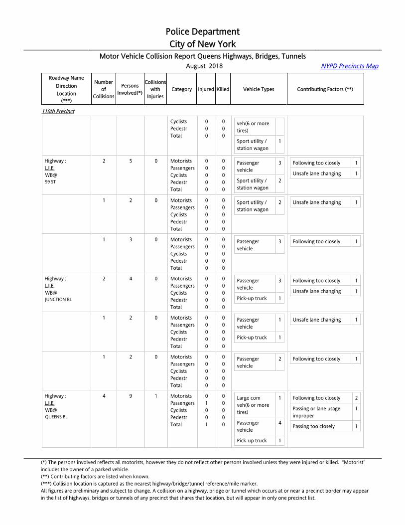
Police DepartmentCity of New York
Motor Vehicle Collision Report Queens Highways, Bridges, Tunnels August 2018 NYPD Precincts Map
Roadway NameDirectionLocation
(***)
Numberof
Collisions
PersonsInvolved(*)
Collisionswith
InjuriesCategory Injured Killed Vehicle Types Contributing Factors (**)
110th Precinct
WB@108 ST
CyclistsPedestrTotal
000
000
veh(6 or more tires)
Sport utility / station wagon
1
Highway :L.I.E.WB@99 ST
2 5 0 MotoristsPassengersCyclistsPedestrTotal
00000
00000
Passenger vehicle
3
Sport utility / station wagon
2
Following too closely 1
Unsafe lane changing 1
Highway :L.I.E.WB@99 ST
1 2 0 MotoristsPassengersCyclistsPedestrTotal
00000
00000
Sport utility / station wagon
2 Unsafe lane changing 1
Highway :L.I.E.WB@99 ST
1 3 0 MotoristsPassengersCyclistsPedestrTotal
00000
00000
Passenger vehicle
3 Following too closely 1
Highway :L.I.E.WB@JUNCTION BL
2 4 0 MotoristsPassengersCyclistsPedestrTotal
00000
00000
Passenger vehicle
3
Pick-up truck 1
Following too closely 1
Unsafe lane changing 1
Highway :L.I.E.WB@JUNCTION BL
1 2 0 MotoristsPassengersCyclistsPedestrTotal
00000
00000
Passenger vehicle
1
Pick-up truck 1
Unsafe lane changing 1
Highway :L.I.E.WB@JUNCTION BL
1 2 0 MotoristsPassengersCyclistsPedestrTotal
00000
00000
Passenger vehicle
2 Following too closely 1
Highway :L.I.E.WB@QUEENS BL
4 9 1 MotoristsPassengersCyclistsPedestrTotal
01001
00000
Large com veh(6 or more tires)
1
Passenger vehicle
4
Pick-up truck 1
Following too closely 2
Passing or lane usage improper
1
Passing too closely 1
(*) The persons involved reflects all motorists, however they do not reflect other persons involved unless they were injured or killed. “Motorist” includes the owner of a parked vehicle.(**) Contributing factors are listed when known.(***) Collision location is captured as the nearest highway/bridge/tunnel reference/mile marker.All figures are preliminary and subject to change. A collision on a highway, bridge or tunnel which occurs at or near a precinct border may appearin the list of highways, bridges or tunnels of any precinct that shares that location, but will appear in only one precinct list.
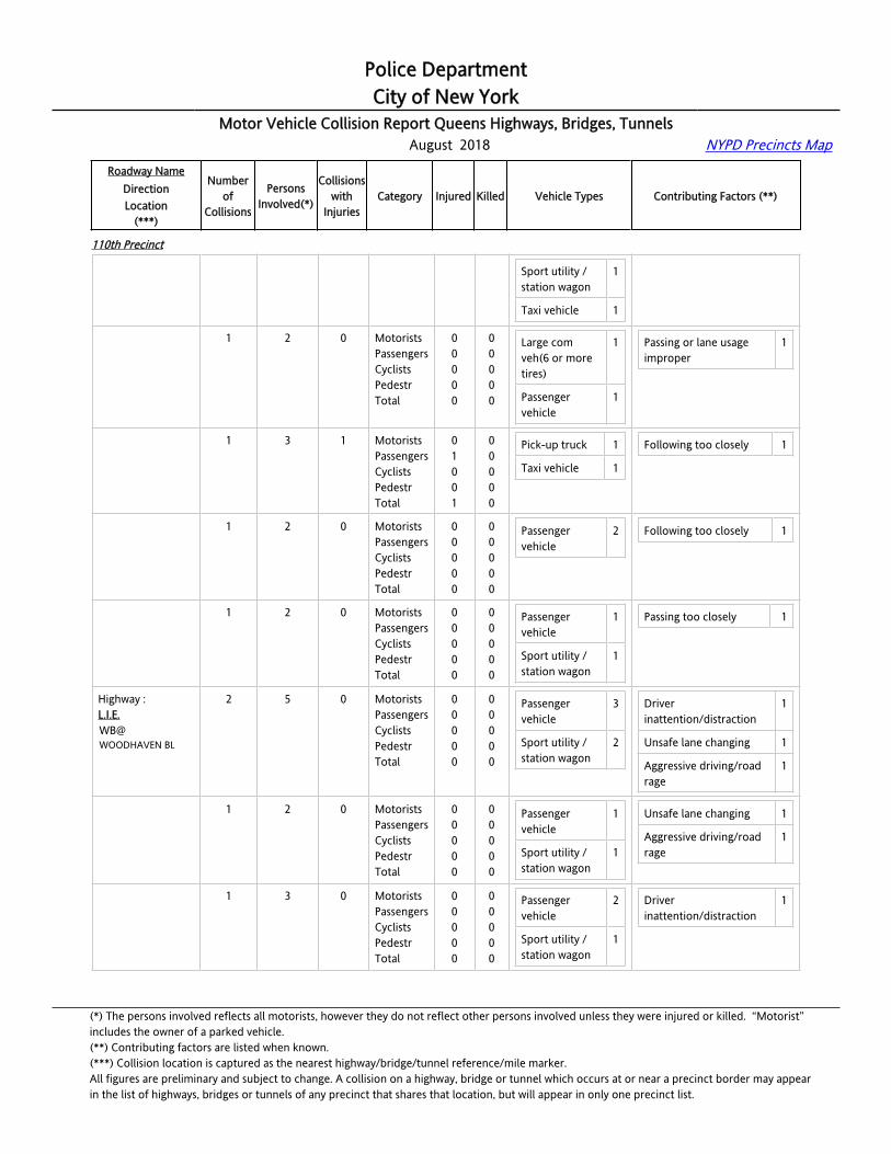
Police DepartmentCity of New York
Motor Vehicle Collision Report Queens Highways, Bridges, Tunnels August 2018 NYPD Precincts Map
Roadway NameDirectionLocation
(***)
Numberof
Collisions
PersonsInvolved(*)
Collisionswith
InjuriesCategory Injured Killed Vehicle Types Contributing Factors (**)
110th Precinct
Sport utility / station wagon
1
Taxi vehicle 1
Highway :L.I.E.WB@QUEENS BL
1 2 0 MotoristsPassengersCyclistsPedestrTotal
00000
00000
Large com veh(6 or more tires)
1
Passenger vehicle
1
Passing or lane usage improper
1
Highway :L.I.E.WB@QUEENS BL
1 3 1 MotoristsPassengersCyclistsPedestrTotal
01001
00000
Pick-up truck 1
Taxi vehicle 1
Following too closely 1
Highway :L.I.E.WB@QUEENS BL
1 2 0 MotoristsPassengersCyclistsPedestrTotal
00000
00000
Passenger vehicle
2 Following too closely 1
Highway :L.I.E.WB@QUEENS BL
1 2 0 MotoristsPassengersCyclistsPedestrTotal
00000
00000
Passenger vehicle
1
Sport utility / station wagon
1
Passing too closely 1
Highway :L.I.E.WB@WOODHAVEN BL
2 5 0 MotoristsPassengersCyclistsPedestrTotal
00000
00000
Passenger vehicle
3
Sport utility / station wagon
2
Driver inattention/distraction
1
Unsafe lane changing 1
Aggressive driving/road rage
1
Highway :L.I.E.WB@WOODHAVEN BL
1 2 0 MotoristsPassengersCyclistsPedestrTotal
00000
00000
Passenger vehicle
1
Sport utility / station wagon
1
Unsafe lane changing 1
Aggressive driving/road rage
1
Highway :L.I.E.WB@WOODHAVEN BL
1 3 0 MotoristsPassengersCyclistsPedestrTotal
00000
00000
Passenger vehicle
2
Sport utility / station wagon
1
Driver inattention/distraction
1
(*) The persons involved reflects all motorists, however they do not reflect other persons involved unless they were injured or killed. “Motorist” includes the owner of a parked vehicle.(**) Contributing factors are listed when known.(***) Collision location is captured as the nearest highway/bridge/tunnel reference/mile marker.All figures are preliminary and subject to change. A collision on a highway, bridge or tunnel which occurs at or near a precinct border may appearin the list of highways, bridges or tunnels of any precinct that shares that location, but will appear in only one precinct list.
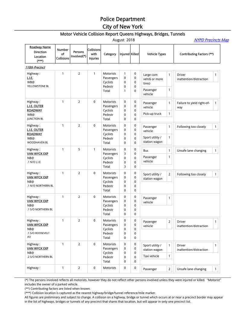
Police DepartmentCity of New York
Motor Vehicle Collision Report Queens Highways, Bridges, Tunnels August 2018 NYPD Precincts Map
Roadway NameDirectionLocation
(***)
Numberof
Collisions
PersonsInvolved(*)
Collisionswith
InjuriesCategory Injured Killed Vehicle Types Contributing Factors (**)
110th Precinct
Highway :L.I.E.WB@YELLOWSTONE BL
1 2 1 MotoristsPassengersCyclistsPedestrTotal
10001
00000
Large com veh(6 or more tires)
1
Passenger vehicle
1
Driver inattention/distraction
1
Highway :L.I.E. OUTER ROADWAYWB@JUNCTION BL
1 2 0 MotoristsPassengersCyclistsPedestrTotal
00000
00000
Passenger vehicle
1
Pick-up truck 1
Failure to yield right-of-way
1
Highway :L.I.E. OUTER ROADWAYWB@WOODHAVEN BL
1 2 0 MotoristsPassengersCyclistsPedestrTotal
00000
00000
Passenger vehicle
1
Sport utility / station wagon
1
Following too closely 1
Highway :VAN WYCK [email protected] N/O L.I.E.
1 5 1 MotoristsPassengersCyclistsPedestrTotal
03003
00000
Bus 1
Passenger vehicle
1
Unsafe lane changing 1
Highway :VAN WYCK [email protected] N/O NORTHERN BL
1 2 0 MotoristsPassengersCyclistsPedestrTotal
00000
00000
Sport utility / station wagon
2 Following too closely 1
Highway :VAN WYCK [email protected] S/O NORTHERN BL
1 2 0 MotoristsPassengersCyclistsPedestrTotal
00000
00000
Passenger vehicle
1
Highway :VAN WYCK [email protected] S/O ROOSEVELT AV
1 2 0 MotoristsPassengersCyclistsPedestrTotal
00000
00000
Passenger vehicle
2 Driver inattention/distraction
1
Highway :VAN WYCK [email protected] S/O NORTHERN BL
1 2 0 MotoristsPassengersCyclistsPedestrTotal
00000
00000
Sport utility / station wagon
1
Taxi vehicle 1
Driver inattention/distraction
1
Highway : 1 2 0 Motorists 0 0 Passenger 2 Unsafe lane changing 1
(*) The persons involved reflects all motorists, however they do not reflect other persons involved unless they were injured or killed. “Motorist” includes the owner of a parked vehicle.(**) Contributing factors are listed when known.(***) Collision location is captured as the nearest highway/bridge/tunnel reference/mile marker.All figures are preliminary and subject to change. A collision on a highway, bridge or tunnel which occurs at or near a precinct border may appearin the list of highways, bridges or tunnels of any precinct that shares that location, but will appear in only one precinct list.

Police DepartmentCity of New York
Motor Vehicle Collision Report Queens Highways, Bridges, Tunnels August 2018 NYPD Precincts Map
Roadway NameDirectionLocation
(***)
Numberof
Collisions
PersonsInvolved(*)
Collisionswith
InjuriesCategory Injured Killed Vehicle Types Contributing Factors (**)
110th Precinct
VAN WYCK [email protected] N/O FOWLER AV
PassengersCyclistsPedestrTotal
0000
0000
vehicle
Highway :VAN WYCK [email protected] N/O JEWEL AV
6 13 1 MotoristsPassengersCyclistsPedestrTotal
10001
00000
Large com veh(6 or more tires)
4
Passenger vehicle
6
Sport utility / station wagon
2
Van 1
Driver inattention/distraction
2
Following too closely 1
Highway :VAN WYCK [email protected] N/O JEWEL AV
1 2 1 MotoristsPassengersCyclistsPedestrTotal
10001
00000
Sport utility / station wagon
1
Van 1
Following too closely 1
Highway :VAN WYCK [email protected] N/O JEWEL AV
1 2 0 MotoristsPassengersCyclistsPedestrTotal
00000
00000
Large com veh(6 or more tires)
1
Passenger vehicle
1
Highway :VAN WYCK [email protected] N/O JEWEL AV
1 2 0 MotoristsPassengersCyclistsPedestrTotal
00000
00000
Passenger vehicle
2 Driver inattention/distraction
1
Highway :VAN WYCK [email protected] N/O JEWEL AV
1 3 0 MotoristsPassengersCyclistsPedestrTotal
00000
00000
Large com veh(6 or more tires)
1
Passenger vehicle
1
Sport utility / station wagon
1
Highway :VAN WYCK [email protected] N/O JEWEL AV
1 2 0 MotoristsPassengersCyclistsPedestrTotal
00000
00000
Large com veh(6 or more tires)
1
Passenger 1
Driver inattention/distraction
1
(*) The persons involved reflects all motorists, however they do not reflect other persons involved unless they were injured or killed. “Motorist” includes the owner of a parked vehicle.(**) Contributing factors are listed when known.(***) Collision location is captured as the nearest highway/bridge/tunnel reference/mile marker.All figures are preliminary and subject to change. A collision on a highway, bridge or tunnel which occurs at or near a precinct border may appearin the list of highways, bridges or tunnels of any precinct that shares that location, but will appear in only one precinct list.

Police DepartmentCity of New York
Motor Vehicle Collision Report Queens Highways, Bridges, Tunnels August 2018 NYPD Precincts Map
Roadway NameDirectionLocation
(***)
Numberof
Collisions
PersonsInvolved(*)
Collisionswith
InjuriesCategory Injured Killed Vehicle Types Contributing Factors (**)
110th Precinct
vehicle
Highway :VAN WYCK [email protected] N/O JEWEL AV
1 2 0 MotoristsPassengersCyclistsPedestrTotal
00000
00000
Large com veh(6 or more tires)
1
Passenger vehicle
1
Highway :VAN WYCK [email protected] N/O L.I.E.
1 2 0 MotoristsPassengersCyclistsPedestrTotal
00000
00000
Passenger vehicle
2 Following too closely 1
Highway :VAN WYCK [email protected] N/O NORTHERN BL
1 2 0 MotoristsPassengersCyclistsPedestrTotal
00000
00000
Large com veh(6 or more tires)
1
Passenger vehicle
1
Driver inattention/distraction
1
Highway :VAN WYCK [email protected] N/O ROOSEVELT AV
1 7 1 MotoristsPassengersCyclistsPedestrTotal
04004
00000
Sport utility / station wagon
2
Taxi vehicle 1
Following too closely 1
Highway :VAN WYCK [email protected] S/O ROOSEVELT AV
1 4 1 MotoristsPassengersCyclistsPedestrTotal
02002
00000
Sport utility / station wagon
2 Following too closely 1
Highway :VAN WYCK [email protected] N/O JEWEL AV
1 2 0 MotoristsPassengersCyclistsPedestrTotal
00000
00000
Passenger vehicle
1
Pick-up truck 1
Failure to yield right-of-way
1
Highway :VAN WYCK [email protected] S/O L.I.E.
1 2 0 MotoristsPassengersCyclistsPedestrTotal
00000
00000
Large com veh(6 or more tires)
1
Passenger vehicle
1
Following too closely 1
Highway :VAN WYCK EXPSB@
2 4 1 MotoristsPassengersCyclists
200
000
Passenger vehicle
2 Driver inattention/distraction
3
(*) The persons involved reflects all motorists, however they do not reflect other persons involved unless they were injured or killed. “Motorist” includes the owner of a parked vehicle.(**) Contributing factors are listed when known.(***) Collision location is captured as the nearest highway/bridge/tunnel reference/mile marker.All figures are preliminary and subject to change. A collision on a highway, bridge or tunnel which occurs at or near a precinct border may appearin the list of highways, bridges or tunnels of any precinct that shares that location, but will appear in only one precinct list.

Police DepartmentCity of New York
Motor Vehicle Collision Report Queens Highways, Bridges, Tunnels August 2018 NYPD Precincts Map
Roadway NameDirectionLocation
(***)
Numberof
Collisions
PersonsInvolved(*)
Collisionswith
InjuriesCategory Injured Killed Vehicle Types Contributing Factors (**)
110th Precinct
.3 N/O JEWEL AV PedestrTotal
02
00
Sport utility / station wagon
1
Taxi vehicle 1
Highway :VAN WYCK [email protected] N/O JEWEL AV
1 2 1 MotoristsPassengersCyclistsPedestrTotal
20002
00000
Passenger vehicle
1
Sport utility / station wagon
1
Driver inattention/distraction
1
Highway :VAN WYCK [email protected] N/O JEWEL AV
1 2 0 MotoristsPassengersCyclistsPedestrTotal
00000
00000
Passenger vehicle
1
Taxi vehicle 1
Driver inattention/distraction
2
Highway :VAN WYCK [email protected] S/O L.I.E.
2 4 1 MotoristsPassengersCyclistsPedestrTotal
10001
00000
Passenger vehicle
2
Pick-up truck 1
Sport utility / station wagon
1
Driver inexperience 1
Following too closely 1
Highway :VAN WYCK [email protected] S/O L.I.E.
1 2 1 MotoristsPassengersCyclistsPedestrTotal
10001
00000
Pick-up truck 1
Sport utility / station wagon
1
Driver inexperience 1
Highway :VAN WYCK [email protected] S/O L.I.E.
1 2 0 MotoristsPassengersCyclistsPedestrTotal
00000
00000
Passenger vehicle
2 Following too closely 1
Highway :VAN WYCK [email protected] N/O JEWEL AV
1 2 0 MotoristsPassengersCyclistsPedestrTotal
00000
00000
Sport utility / station wagon
2 Driver inattention/distraction
1
Highway :VAN WYCK EXPSB@LONG ISLAND EXP
1 2 0 MotoristsPassengersCyclistsPedestrTotal
00000
00000
Passenger vehicle
1
Sport utility / station wagon
1
Following too closely 1
Highway :VAN WYCK EXP
1 2 1 MotoristsPassengers
10
00
Sport utility / 1
(*) The persons involved reflects all motorists, however they do not reflect other persons involved unless they were injured or killed. “Motorist” includes the owner of a parked vehicle.(**) Contributing factors are listed when known.(***) Collision location is captured as the nearest highway/bridge/tunnel reference/mile marker.All figures are preliminary and subject to change. A collision on a highway, bridge or tunnel which occurs at or near a precinct border may appearin the list of highways, bridges or tunnels of any precinct that shares that location, but will appear in only one precinct list.

Police DepartmentCity of New York
Motor Vehicle Collision Report Queens Highways, Bridges, Tunnels August 2018 NYPD Precincts Map
Roadway NameDirectionLocation
(***)
Numberof
Collisions
PersonsInvolved(*)
Collisionswith
InjuriesCategory Injured Killed Vehicle Types Contributing Factors (**)
110th Precinct
SB@WHITESTONE EXP
CyclistsPedestrTotal
001
000
station wagon
Van 1
111th Precinct
Highway :CLEARVIEW EXPNB@33 AV
1 2 0 MotoristsPassengersCyclistsPedestrTotal
00000
00000
Passenger vehicle
2 Driver inattention/distraction
1
Highway :CLEARVIEW EXPNB@36 AV
1 2 0 MotoristsPassengersCyclistsPedestrTotal
00000
00000
Passenger vehicle
1
Sport utility / station wagon
1
Highway :CLEARVIEW EXPNB@HOR HARDING EXP WB
1 2 0 MotoristsPassengersCyclistsPedestrTotal
00000
00000
Passenger vehicle
2 Passing or lane usage improper
1
Unsafe lane changing 1
Highway :CLEARVIEW EXPNB@LONG ISLAND EXP
1 2 0 MotoristsPassengersCyclistsPedestrTotal
00000
00000
Passenger vehicle
1
Sport utility / station wagon
1
Following too closely 1
Highway :CLEARVIEW EXPSB@56 AV
1 2 0 MotoristsPassengersCyclistsPedestrTotal
00000
00000
Bus 1
Sport utility / station wagon
1
Driver inattention/distraction
1
Highway :CLEARVIEW EXPSB@HOR HARDING EXP EB
1 3 0 MotoristsPassengersCyclistsPedestrTotal
00000
00000
Passenger vehicle
1
Pick-up truck 1
Small com veh(4 tires)
1
Driver inattention/distraction
1
Highway :CLEARVIEW EXPSB@HOR HARDING EXP WB
1 2 0 MotoristsPassengersCyclistsPedestrTotal
00000
00000
Passenger vehicle
1
Small com veh(4 tires)
1
Failure to yield right-of-way
1
(*) The persons involved reflects all motorists, however they do not reflect other persons involved unless they were injured or killed. “Motorist” includes the owner of a parked vehicle.(**) Contributing factors are listed when known.(***) Collision location is captured as the nearest highway/bridge/tunnel reference/mile marker.All figures are preliminary and subject to change. A collision on a highway, bridge or tunnel which occurs at or near a precinct border may appearin the list of highways, bridges or tunnels of any precinct that shares that location, but will appear in only one precinct list.

Police DepartmentCity of New York
Motor Vehicle Collision Report Queens Highways, Bridges, Tunnels August 2018 NYPD Precincts Map
Roadway NameDirectionLocation
(***)
Numberof
Collisions
PersonsInvolved(*)
Collisionswith
InjuriesCategory Injured Killed Vehicle Types Contributing Factors (**)
111th Precinct
Highway :CLEARVIEW EXPSB@LONG ISLAND EXP
2 4 0 MotoristsPassengersCyclistsPedestrTotal
00000
00000
Large com veh(6 or more tires)
1
Sport utility / station wagon
3
Failure to yield right-of-way
1
Passing or lane usage improper
1
Highway :CLEARVIEW EXPSB@LONG ISLAND EXP
1 2 0 MotoristsPassengersCyclistsPedestrTotal
00000
00000
Large com veh(6 or more tires)
1
Sport utility / station wagon
1
Passing or lane usage improper
1
Highway :CLEARVIEW EXPSB@LONG ISLAND EXP
1 2 0 MotoristsPassengersCyclistsPedestrTotal
00000
00000
Sport utility / station wagon
2 Failure to yield right-of-way
1
Highway :CLEARVIEW EXPSB@NORTHERN BL
2 6 1 MotoristsPassengersCyclistsPedestrTotal
12003
00000
Large com veh(6 or more tires)
1
Passenger vehicle
1
Sport utility / station wagon
2
Driver inattention/distraction
1
Unsafe lane changing 1
Highway :CLEARVIEW EXPSB@NORTHERN BL
1 4 1 MotoristsPassengersCyclistsPedestrTotal
12003
00000
Sport utility / station wagon
2 Driver inattention/distraction
1
Highway :CLEARVIEW EXPSB@NORTHERN BL
1 2 0 MotoristsPassengersCyclistsPedestrTotal
00000
00000
Large com veh(6 or more tires)
1
Passenger vehicle
1
Unsafe lane changing 1
Highway :CROSS ISLAND [email protected] N/O L.I.E.
3 7 0 MotoristsPassengersCyclistsPedestrTotal
00000
00000
Passenger vehicle
4
Sport utility / station wagon
3
Following too closely 4
Highway : 1 2 0 Motorists 0 0 Passenger 1 Following too closely 1
(*) The persons involved reflects all motorists, however they do not reflect other persons involved unless they were injured or killed. “Motorist” includes the owner of a parked vehicle.(**) Contributing factors are listed when known.(***) Collision location is captured as the nearest highway/bridge/tunnel reference/mile marker.All figures are preliminary and subject to change. A collision on a highway, bridge or tunnel which occurs at or near a precinct border may appearin the list of highways, bridges or tunnels of any precinct that shares that location, but will appear in only one precinct list.
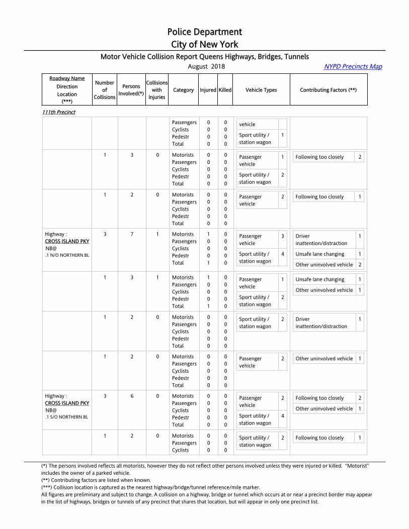
Police DepartmentCity of New York
Motor Vehicle Collision Report Queens Highways, Bridges, Tunnels August 2018 NYPD Precincts Map
Roadway NameDirectionLocation
(***)
Numberof
Collisions
PersonsInvolved(*)
Collisionswith
InjuriesCategory Injured Killed Vehicle Types Contributing Factors (**)
111th Precinct
CROSS ISLAND [email protected] N/O L.I.E.
PassengersCyclistsPedestrTotal
0000
0000
vehicle
Sport utility / station wagon
1
Highway :CROSS ISLAND [email protected] N/O L.I.E.
1 3 0 MotoristsPassengersCyclistsPedestrTotal
00000
00000
Passenger vehicle
1
Sport utility / station wagon
2
Following too closely 2
Highway :CROSS ISLAND [email protected] N/O L.I.E.
1 2 0 MotoristsPassengersCyclistsPedestrTotal
00000
00000
Passenger vehicle
2 Following too closely 1
Highway :CROSS ISLAND [email protected] N/O NORTHERN BL
3 7 1 MotoristsPassengersCyclistsPedestrTotal
10001
00000
Passenger vehicle
3
Sport utility / station wagon
4
Driver inattention/distraction
1
Unsafe lane changing 1
Other uninvolved vehicle 2
Highway :CROSS ISLAND [email protected] N/O NORTHERN BL
1 3 1 MotoristsPassengersCyclistsPedestrTotal
10001
00000
Passenger vehicle
1
Sport utility / station wagon
2
Unsafe lane changing 1
Other uninvolved vehicle 1
Highway :CROSS ISLAND [email protected] N/O NORTHERN BL
1 2 0 MotoristsPassengersCyclistsPedestrTotal
00000
00000
Sport utility / station wagon
2 Driver inattention/distraction
1
Highway :CROSS ISLAND [email protected] N/O NORTHERN BL
1 2 0 MotoristsPassengersCyclistsPedestrTotal
00000
00000
Passenger vehicle
2 Other uninvolved vehicle 1
Highway :CROSS ISLAND [email protected] S/O NORTHERN BL
3 6 0 MotoristsPassengersCyclistsPedestrTotal
00000
00000
Passenger vehicle
2
Sport utility / station wagon
4
Following too closely 2
Other uninvolved vehicle 1
Highway :CROSS ISLAND PKYNB@
1 2 0 MotoristsPassengersCyclists
000
000
Sport utility / station wagon
2 Following too closely 1
(*) The persons involved reflects all motorists, however they do not reflect other persons involved unless they were injured or killed. “Motorist” includes the owner of a parked vehicle.(**) Contributing factors are listed when known.(***) Collision location is captured as the nearest highway/bridge/tunnel reference/mile marker.All figures are preliminary and subject to change. A collision on a highway, bridge or tunnel which occurs at or near a precinct border may appearin the list of highways, bridges or tunnels of any precinct that shares that location, but will appear in only one precinct list.
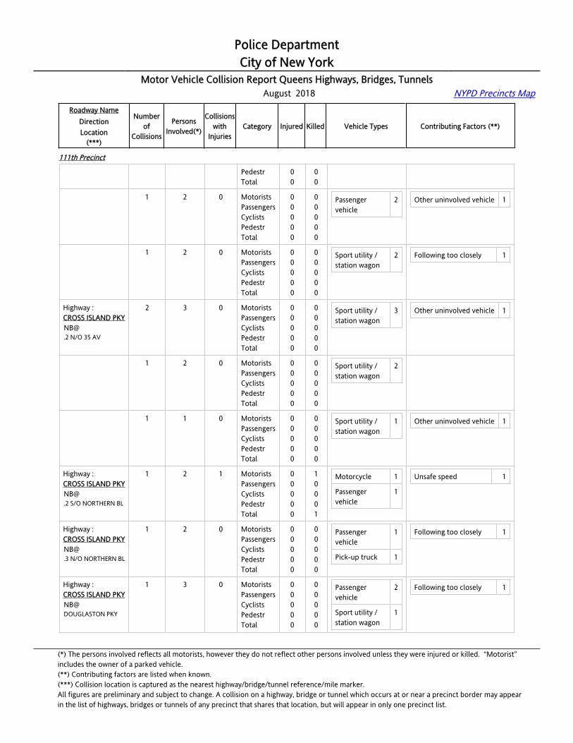
Police DepartmentCity of New York
Motor Vehicle Collision Report Queens Highways, Bridges, Tunnels August 2018 NYPD Precincts Map
Roadway NameDirectionLocation
(***)
Numberof
Collisions
PersonsInvolved(*)
Collisionswith
InjuriesCategory Injured Killed Vehicle Types Contributing Factors (**)
111th Precinct
.1 S/O NORTHERN BL PedestrTotal
00
00
Highway :CROSS ISLAND [email protected] S/O NORTHERN BL
1 2 0 MotoristsPassengersCyclistsPedestrTotal
00000
00000
Passenger vehicle
2 Other uninvolved vehicle 1
Highway :CROSS ISLAND [email protected] S/O NORTHERN BL
1 2 0 MotoristsPassengersCyclistsPedestrTotal
00000
00000
Sport utility / station wagon
2 Following too closely 1
Highway :CROSS ISLAND [email protected] N/O 35 AV
2 3 0 MotoristsPassengersCyclistsPedestrTotal
00000
00000
Sport utility / station wagon
3 Other uninvolved vehicle 1
Highway :CROSS ISLAND [email protected] N/O 35 AV
1 2 0 MotoristsPassengersCyclistsPedestrTotal
00000
00000
Sport utility / station wagon
2
Highway :CROSS ISLAND [email protected] N/O 35 AV
1 1 0 MotoristsPassengersCyclistsPedestrTotal
00000
00000
Sport utility / station wagon
1 Other uninvolved vehicle 1
Highway :CROSS ISLAND [email protected] S/O NORTHERN BL
1 2 1 MotoristsPassengersCyclistsPedestrTotal
00000
10001
Motorcycle 1
Passenger vehicle
1
Unsafe speed 1
Highway :CROSS ISLAND [email protected] N/O NORTHERN BL
1 2 0 MotoristsPassengersCyclistsPedestrTotal
00000
00000
Passenger vehicle
1
Pick-up truck 1
Following too closely 1
Highway :CROSS ISLAND PKYNB@DOUGLASTON PKY
1 3 0 MotoristsPassengersCyclistsPedestrTotal
00000
00000
Passenger vehicle
2
Sport utility / station wagon
1
Following too closely 1
(*) The persons involved reflects all motorists, however they do not reflect other persons involved unless they were injured or killed. “Motorist” includes the owner of a parked vehicle.(**) Contributing factors are listed when known.(***) Collision location is captured as the nearest highway/bridge/tunnel reference/mile marker.All figures are preliminary and subject to change. A collision on a highway, bridge or tunnel which occurs at or near a precinct border may appearin the list of highways, bridges or tunnels of any precinct that shares that location, but will appear in only one precinct list.

Police DepartmentCity of New York
Motor Vehicle Collision Report Queens Highways, Bridges, Tunnels August 2018 NYPD Precincts Map
Roadway NameDirectionLocation
(***)
Numberof
Collisions
PersonsInvolved(*)
Collisionswith
InjuriesCategory Injured Killed Vehicle Types Contributing Factors (**)
111th Precinct
Highway :CROSS ISLAND [email protected].
6 12 1 MotoristsPassengersCyclistsPedestrTotal
10001
00000
Passenger vehicle
4
Pick-up truck 3
Sport utility / station wagon
4
Driver inattention/distraction
3
Following too closely 1
Unsafe speed 1
Highway :CROSS ISLAND [email protected].
1 2 0 MotoristsPassengersCyclistsPedestrTotal
00000
00000
Pick-up truck 2 Driver inattention/distraction
1
Highway :CROSS ISLAND [email protected].
1 2 0 MotoristsPassengersCyclistsPedestrTotal
00000
00000
Passenger vehicle
1
Sport utility / station wagon
1
Following too closely 1
Highway :CROSS ISLAND [email protected].
1 2 0 MotoristsPassengersCyclistsPedestrTotal
00000
00000
Pick-up truck 1
Sport utility / station wagon
1
Driver inattention/distraction
1
Highway :CROSS ISLAND [email protected].
1 2 0 MotoristsPassengersCyclistsPedestrTotal
00000
00000
Passenger vehicle
1
Sport utility / station wagon
1
Driver inattention/distraction
1
Highway :CROSS ISLAND [email protected].
1 2 1 MotoristsPassengersCyclistsPedestrTotal
10001
00000
Passenger vehicle
1
Highway :CROSS ISLAND [email protected].
1 2 0 MotoristsPassengersCyclistsPedestrTotal
00000
00000
Passenger vehicle
1
Sport utility / station wagon
1
Unsafe speed 1
Highway :CROSS ISLAND PKYNB@W ALLEY ROAD
1 2 0 MotoristsPassengersCyclistsPedestrTotal
00000
00000
Sport utility / station wagon
2 Driver inattention/distraction
1
(*) The persons involved reflects all motorists, however they do not reflect other persons involved unless they were injured or killed. “Motorist” includes the owner of a parked vehicle.(**) Contributing factors are listed when known.(***) Collision location is captured as the nearest highway/bridge/tunnel reference/mile marker.All figures are preliminary and subject to change. A collision on a highway, bridge or tunnel which occurs at or near a precinct border may appearin the list of highways, bridges or tunnels of any precinct that shares that location, but will appear in only one precinct list.
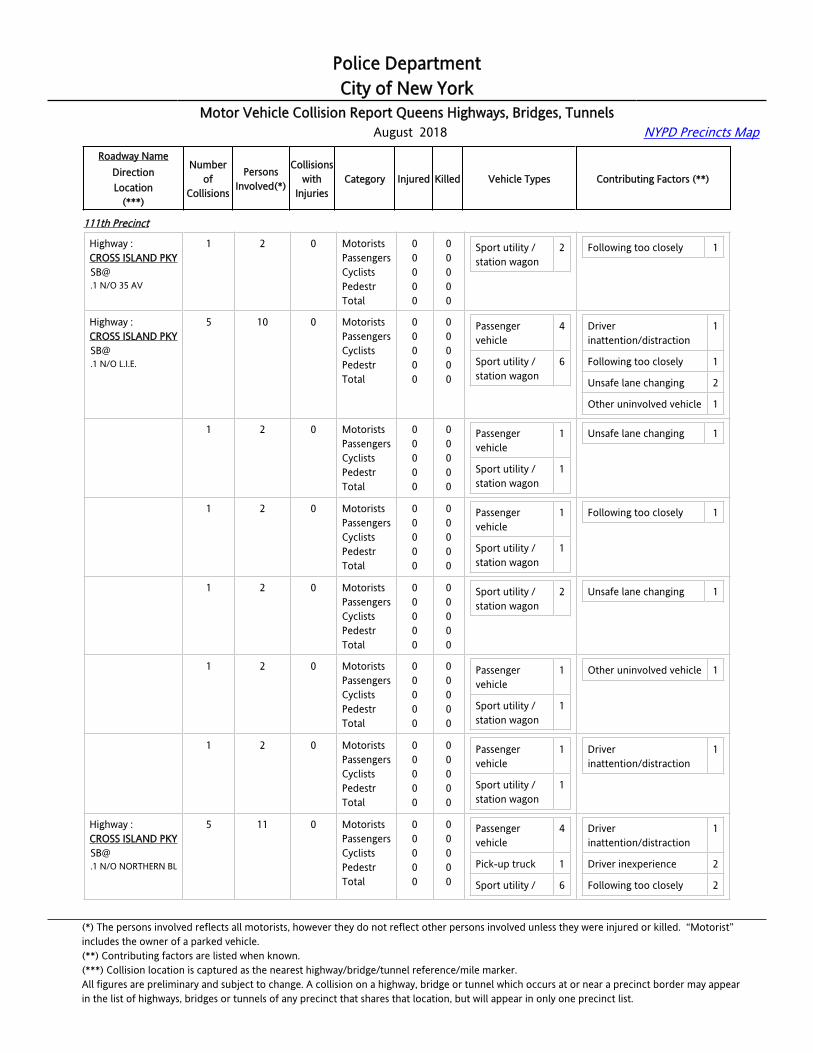
Police DepartmentCity of New York
Motor Vehicle Collision Report Queens Highways, Bridges, Tunnels August 2018 NYPD Precincts Map
Roadway NameDirectionLocation
(***)
Numberof
Collisions
PersonsInvolved(*)
Collisionswith
InjuriesCategory Injured Killed Vehicle Types Contributing Factors (**)
111th Precinct
Highway :CROSS ISLAND [email protected] N/O 35 AV
1 2 0 MotoristsPassengersCyclistsPedestrTotal
00000
00000
Sport utility / station wagon
2 Following too closely 1
Highway :CROSS ISLAND [email protected] N/O L.I.E.
5 10 0 MotoristsPassengersCyclistsPedestrTotal
00000
00000
Passenger vehicle
4
Sport utility / station wagon
6
Driver inattention/distraction
1
Following too closely 1
Unsafe lane changing 2
Other uninvolved vehicle 1
Highway :CROSS ISLAND [email protected] N/O L.I.E.
1 2 0 MotoristsPassengersCyclistsPedestrTotal
00000
00000
Passenger vehicle
1
Sport utility / station wagon
1
Unsafe lane changing 1
Highway :CROSS ISLAND [email protected] N/O L.I.E.
1 2 0 MotoristsPassengersCyclistsPedestrTotal
00000
00000
Passenger vehicle
1
Sport utility / station wagon
1
Following too closely 1
Highway :CROSS ISLAND [email protected] N/O L.I.E.
1 2 0 MotoristsPassengersCyclistsPedestrTotal
00000
00000
Sport utility / station wagon
2 Unsafe lane changing 1
Highway :CROSS ISLAND [email protected] N/O L.I.E.
1 2 0 MotoristsPassengersCyclistsPedestrTotal
00000
00000
Passenger vehicle
1
Sport utility / station wagon
1
Other uninvolved vehicle 1
Highway :CROSS ISLAND [email protected] N/O L.I.E.
1 2 0 MotoristsPassengersCyclistsPedestrTotal
00000
00000
Passenger vehicle
1
Sport utility / station wagon
1
Driver inattention/distraction
1
Highway :CROSS ISLAND [email protected] N/O NORTHERN BL
5 11 0 MotoristsPassengersCyclistsPedestrTotal
00000
00000
Passenger vehicle
4
Pick-up truck 1
Sport utility / 6
Driver inattention/distraction
1
Driver inexperience 2
Following too closely 2
(*) The persons involved reflects all motorists, however they do not reflect other persons involved unless they were injured or killed. “Motorist” includes the owner of a parked vehicle.(**) Contributing factors are listed when known.(***) Collision location is captured as the nearest highway/bridge/tunnel reference/mile marker.All figures are preliminary and subject to change. A collision on a highway, bridge or tunnel which occurs at or near a precinct border may appearin the list of highways, bridges or tunnels of any precinct that shares that location, but will appear in only one precinct list.

Police DepartmentCity of New York
Motor Vehicle Collision Report Queens Highways, Bridges, Tunnels August 2018 NYPD Precincts Map
Roadway NameDirectionLocation
(***)
Numberof
Collisions
PersonsInvolved(*)
Collisionswith
InjuriesCategory Injured Killed Vehicle Types Contributing Factors (**)
111th Precinct
station wagon Unsafe lane changing 1
Highway :CROSS ISLAND [email protected] N/O NORTHERN BL
1 2 0 MotoristsPassengersCyclistsPedestrTotal
00000
00000
Pick-up truck 1
Sport utility / station wagon
1
Driver inattention/distraction
1
Highway :CROSS ISLAND [email protected] N/O NORTHERN BL
1 2 0 MotoristsPassengersCyclistsPedestrTotal
00000
00000
Sport utility / station wagon
2 Following too closely 1
Highway :CROSS ISLAND [email protected] N/O NORTHERN BL
1 2 0 MotoristsPassengersCyclistsPedestrTotal
00000
00000
Sport utility / station wagon
2 Following too closely 1
Highway :CROSS ISLAND [email protected] N/O NORTHERN BL
1 3 0 MotoristsPassengersCyclistsPedestrTotal
00000
00000
Passenger vehicle
2
Sport utility / station wagon
1
Driver inexperience 2
Highway :CROSS ISLAND [email protected] N/O NORTHERN BL
1 2 0 MotoristsPassengersCyclistsPedestrTotal
00000
00000
Passenger vehicle
2 Unsafe lane changing 1
Highway :CROSS ISLAND [email protected] S/O NORTHERN BL
2 4 0 MotoristsPassengersCyclistsPedestrTotal
00000
00000
Passenger vehicle
1
Sport utility / station wagon
3
Driver inattention/distraction
1
Following too closely 1
Highway :CROSS ISLAND [email protected] S/O NORTHERN BL
1 2 0 MotoristsPassengersCyclistsPedestrTotal
00000
00000
Sport utility / station wagon
2 Following too closely 1
Highway :CROSS ISLAND [email protected] S/O NORTHERN BL
1 2 0 MotoristsPassengersCyclistsPedestrTotal
00000
00000
Passenger vehicle
1
Sport utility / station wagon
1
Driver inattention/distraction
1
(*) The persons involved reflects all motorists, however they do not reflect other persons involved unless they were injured or killed. “Motorist” includes the owner of a parked vehicle.(**) Contributing factors are listed when known.(***) Collision location is captured as the nearest highway/bridge/tunnel reference/mile marker.All figures are preliminary and subject to change. A collision on a highway, bridge or tunnel which occurs at or near a precinct border may appearin the list of highways, bridges or tunnels of any precinct that shares that location, but will appear in only one precinct list.

Police DepartmentCity of New York
Motor Vehicle Collision Report Queens Highways, Bridges, Tunnels August 2018 NYPD Precincts Map
Roadway NameDirectionLocation
(***)
Numberof
Collisions
PersonsInvolved(*)
Collisionswith
InjuriesCategory Injured Killed Vehicle Types Contributing Factors (**)
111th Precinct
Highway :CROSS ISLAND [email protected] S/O W ALLEY RD
1 2 1 MotoristsPassengersCyclistsPedestrTotal
10001
00000
Passenger vehicle
1
Sport utility / station wagon
1
Driver inattention/distraction
1
Highway :CROSS ISLAND [email protected] N/O 35 AV
1 2 0 MotoristsPassengersCyclistsPedestrTotal
00000
00000
Passenger vehicle
1
Pick-up truck 1
Following too closely 1
Highway :CROSS ISLAND [email protected] N/O L.I.E.
2 6 1 MotoristsPassengersCyclistsPedestrTotal
21003
00000
Passenger vehicle
1
Sport utility / station wagon
3
Taxi vehicle 1
Driver inattention/distraction
1
Following too closely 1
Highway :CROSS ISLAND [email protected] N/O L.I.E.
1 2 0 MotoristsPassengersCyclistsPedestrTotal
00000
00000
Sport utility / station wagon
2 Following too closely 1
Highway :CROSS ISLAND [email protected] N/O L.I.E.
1 4 1 MotoristsPassengersCyclistsPedestrTotal
21003
00000
Passenger vehicle
1
Sport utility / station wagon
1
Taxi vehicle 1
Driver inattention/distraction
1
Highway :CROSS ISLAND [email protected] N/O NORTHERN BL
3 6 0 MotoristsPassengersCyclistsPedestrTotal
00000
00000
Large com veh(6 or more tires)
1
Passenger vehicle
3
Sport utility / station wagon
2
Driver inattention/distraction
2
Passing or lane usage improper
1
Unsafe lane changing 1
Highway :CROSS ISLAND [email protected] N/O NORTHERN BL
1 2 0 MotoristsPassengersCyclistsPedestrTotal
00000
00000
Passenger vehicle
1
Sport utility / station wagon
1
Passing or lane usage improper
1
Unsafe lane changing 1
Highway : 1 2 0 Motorists 0 0 Large com 1 Driver 1
(*) The persons involved reflects all motorists, however they do not reflect other persons involved unless they were injured or killed. “Motorist” includes the owner of a parked vehicle.(**) Contributing factors are listed when known.(***) Collision location is captured as the nearest highway/bridge/tunnel reference/mile marker.All figures are preliminary and subject to change. A collision on a highway, bridge or tunnel which occurs at or near a precinct border may appearin the list of highways, bridges or tunnels of any precinct that shares that location, but will appear in only one precinct list.
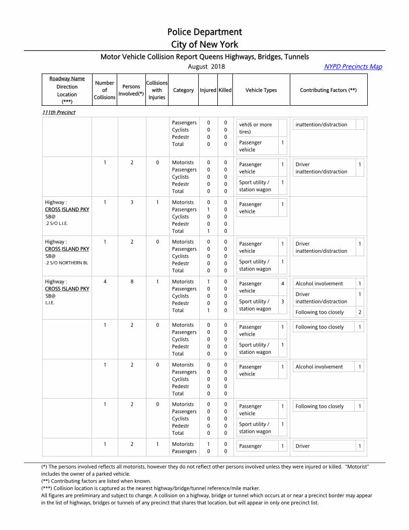
Police DepartmentCity of New York
Motor Vehicle Collision Report Queens Highways, Bridges, Tunnels August 2018 NYPD Precincts Map
Roadway NameDirectionLocation
(***)
Numberof
Collisions
PersonsInvolved(*)
Collisionswith
InjuriesCategory Injured Killed Vehicle Types Contributing Factors (**)
111th Precinct
CROSS ISLAND [email protected] N/O NORTHERN BL
PassengersCyclistsPedestrTotal
0000
0000
veh(6 or more tires)
Passenger vehicle
1
inattention/distraction
Highway :CROSS ISLAND [email protected] N/O NORTHERN BL
1 2 0 MotoristsPassengersCyclistsPedestrTotal
00000
00000
Passenger vehicle
1
Sport utility / station wagon
1
Driver inattention/distraction
1
Highway :CROSS ISLAND [email protected] S/O L.I.E.
1 3 1 MotoristsPassengersCyclistsPedestrTotal
01001
00000
Passenger vehicle
1
Highway :CROSS ISLAND [email protected] S/O NORTHERN BL
1 2 0 MotoristsPassengersCyclistsPedestrTotal
00000
00000
Passenger vehicle
1
Sport utility / station wagon
1
Driver inattention/distraction
1
Highway :CROSS ISLAND [email protected].
4 8 1 MotoristsPassengersCyclistsPedestrTotal
10001
00000
Passenger vehicle
4
Sport utility / station wagon
3
Alcohol involvement 1
Driver inattention/distraction
1
Following too closely 2
Highway :CROSS ISLAND [email protected].
1 2 0 MotoristsPassengersCyclistsPedestrTotal
00000
00000
Passenger vehicle
1
Sport utility / station wagon
1
Following too closely 1
Highway :CROSS ISLAND [email protected].
1 2 0 MotoristsPassengersCyclistsPedestrTotal
00000
00000
Passenger vehicle
1 Alcohol involvement 1
Highway :CROSS ISLAND [email protected].
1 2 0 MotoristsPassengersCyclistsPedestrTotal
00000
00000
Passenger vehicle
1
Sport utility / station wagon
1
Following too closely 1
Highway :CROSS ISLAND PKY
1 2 1 MotoristsPassengers
10
00
Passenger 1 Driver 1
(*) The persons involved reflects all motorists, however they do not reflect other persons involved unless they were injured or killed. “Motorist” includes the owner of a parked vehicle.(**) Contributing factors are listed when known.(***) Collision location is captured as the nearest highway/bridge/tunnel reference/mile marker.All figures are preliminary and subject to change. A collision on a highway, bridge or tunnel which occurs at or near a precinct border may appearin the list of highways, bridges or tunnels of any precinct that shares that location, but will appear in only one precinct list.
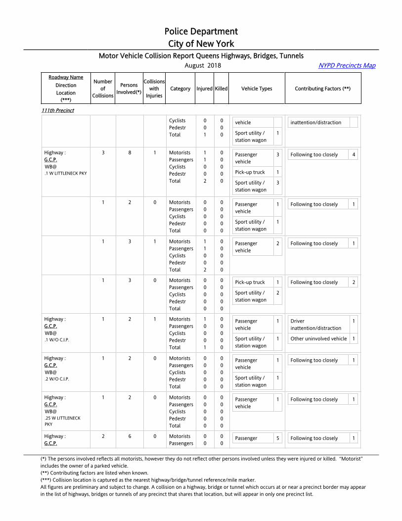
Police DepartmentCity of New York
Motor Vehicle Collision Report Queens Highways, Bridges, Tunnels August 2018 NYPD Precincts Map
Roadway NameDirectionLocation
(***)
Numberof
Collisions
PersonsInvolved(*)
Collisionswith
InjuriesCategory Injured Killed Vehicle Types Contributing Factors (**)
111th Precinct
CyclistsPedestrTotal
001
000
vehicle
Sport utility / station wagon
1
inattention/distraction
Highway :[email protected] W LITTLENECK PKY
3 8 1 MotoristsPassengersCyclistsPedestrTotal
11002
00000
Passenger vehicle
3
Pick-up truck 1
Sport utility / station wagon
3
Following too closely 4
Highway :[email protected] W LITTLENECK PKY
1 2 0 MotoristsPassengersCyclistsPedestrTotal
00000
00000
Passenger vehicle
1
Sport utility / station wagon
1
Following too closely 1
Highway :[email protected] W LITTLENECK PKY
1 3 1 MotoristsPassengersCyclistsPedestrTotal
11002
00000
Passenger vehicle
2 Following too closely 1
Highway :[email protected] W LITTLENECK PKY
1 3 0 MotoristsPassengersCyclistsPedestrTotal
00000
00000
Pick-up truck 1
Sport utility / station wagon
2
Following too closely 2
Highway :[email protected] W/O C.I.P.
1 2 1 MotoristsPassengersCyclistsPedestrTotal
10001
00000
Passenger vehicle
1
Sport utility / station wagon
1
Driver inattention/distraction
1
Other uninvolved vehicle 1
Highway :[email protected] W/O C.I.P.
1 2 0 MotoristsPassengersCyclistsPedestrTotal
00000
00000
Passenger vehicle
1
Sport utility / station wagon
1
Following too closely 1
Highway :[email protected] W LITTLENECK PKY
1 2 0 MotoristsPassengersCyclistsPedestrTotal
00000
00000
Passenger vehicle
1 Following too closely 1
Highway :G.C.P.
2 6 0 MotoristsPassengers
00
00
Passenger 5 Following too closely 1
(*) The persons involved reflects all motorists, however they do not reflect other persons involved unless they were injured or killed. “Motorist” includes the owner of a parked vehicle.(**) Contributing factors are listed when known.(***) Collision location is captured as the nearest highway/bridge/tunnel reference/mile marker.All figures are preliminary and subject to change. A collision on a highway, bridge or tunnel which occurs at or near a precinct border may appearin the list of highways, bridges or tunnels of any precinct that shares that location, but will appear in only one precinct list.

Police DepartmentCity of New York
Motor Vehicle Collision Report Queens Highways, Bridges, Tunnels August 2018 NYPD Precincts Map
Roadway NameDirectionLocation
(***)
Numberof
Collisions
PersonsInvolved(*)
Collisionswith
InjuriesCategory Injured Killed Vehicle Types Contributing Factors (**)
111th Precinct
WB@SPRINGFIELD BL
CyclistsPedestrTotal
000
000
vehicle Other uninvolved vehicle 1
Highway :G.C.P.WB@SPRINGFIELD BL
1 2 0 MotoristsPassengersCyclistsPedestrTotal
00000
00000
Passenger vehicle
2 Following too closely 1
Other uninvolved vehicle 1
Highway :G.C.P.WB@SPRINGFIELD BL
1 4 0 MotoristsPassengersCyclistsPedestrTotal
00000
00000
Passenger vehicle
3
Highway :G.C.P. / C.I.P. CDRWB@ALLEY POND PK S/B EX
1 2 0 MotoristsPassengersCyclistsPedestrTotal
00000
00000
Passenger vehicle
2
Highway :[email protected] E/O C.I.P.
1 2 0 MotoristsPassengersCyclistsPedestrTotal
00000
00000
Sport utility / station wagon
2 Driver inattention/distraction
1
Highway :[email protected] W/O DOUGLASTN PKY
1 3 0 MotoristsPassengersCyclistsPedestrTotal
00000
00000
Passenger vehicle
1
Pick-up truck 1
Sport utility / station wagon
1
Driver inexperience 1
Highway :L.I.E.EB@212 ST
2 4 0 MotoristsPassengersCyclistsPedestrTotal
00000
00000
Large com veh(6 or more tires)
1
Passenger vehicle
2
Sport utility / station wagon
1
Driver inattention/distraction
2
Highway :L.I.E.EB@212 ST
1 2 0 MotoristsPassengersCyclistsPedestrTotal
00000
00000
Large com veh(6 or more tires)
1
Passenger 1
Driver inattention/distraction
1
(*) The persons involved reflects all motorists, however they do not reflect other persons involved unless they were injured or killed. “Motorist” includes the owner of a parked vehicle.(**) Contributing factors are listed when known.(***) Collision location is captured as the nearest highway/bridge/tunnel reference/mile marker.All figures are preliminary and subject to change. A collision on a highway, bridge or tunnel which occurs at or near a precinct border may appearin the list of highways, bridges or tunnels of any precinct that shares that location, but will appear in only one precinct list.
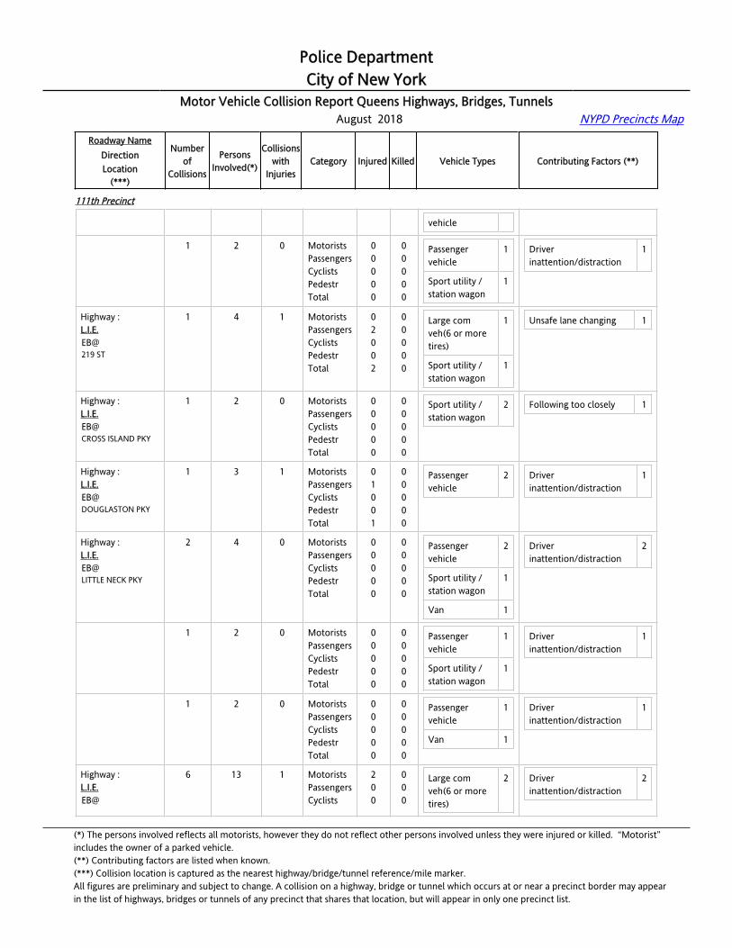
Police DepartmentCity of New York
Motor Vehicle Collision Report Queens Highways, Bridges, Tunnels August 2018 NYPD Precincts Map
Roadway NameDirectionLocation
(***)
Numberof
Collisions
PersonsInvolved(*)
Collisionswith
InjuriesCategory Injured Killed Vehicle Types Contributing Factors (**)
111th Precinct
vehicle
Highway :L.I.E.EB@212 ST
1 2 0 MotoristsPassengersCyclistsPedestrTotal
00000
00000
Passenger vehicle
1
Sport utility / station wagon
1
Driver inattention/distraction
1
Highway :L.I.E.EB@219 ST
1 4 1 MotoristsPassengersCyclistsPedestrTotal
02002
00000
Large com veh(6 or more tires)
1
Sport utility / station wagon
1
Unsafe lane changing 1
Highway :L.I.E.EB@CROSS ISLAND PKY
1 2 0 MotoristsPassengersCyclistsPedestrTotal
00000
00000
Sport utility / station wagon
2 Following too closely 1
Highway :L.I.E.EB@DOUGLASTON PKY
1 3 1 MotoristsPassengersCyclistsPedestrTotal
01001
00000
Passenger vehicle
2 Driver inattention/distraction
1
Highway :L.I.E.EB@LITTLE NECK PKY
2 4 0 MotoristsPassengersCyclistsPedestrTotal
00000
00000
Passenger vehicle
2
Sport utility / station wagon
1
Van 1
Driver inattention/distraction
2
Highway :L.I.E.EB@LITTLE NECK PKY
1 2 0 MotoristsPassengersCyclistsPedestrTotal
00000
00000
Passenger vehicle
1
Sport utility / station wagon
1
Driver inattention/distraction
1
Highway :L.I.E.EB@LITTLE NECK PKY
1 2 0 MotoristsPassengersCyclistsPedestrTotal
00000
00000
Passenger vehicle
1
Van 1
Driver inattention/distraction
1
Highway :L.I.E.EB@
6 13 1 MotoristsPassengersCyclists
200
000
Large com veh(6 or more tires)
2 Driver inattention/distraction
2
(*) The persons involved reflects all motorists, however they do not reflect other persons involved unless they were injured or killed. “Motorist” includes the owner of a parked vehicle.(**) Contributing factors are listed when known.(***) Collision location is captured as the nearest highway/bridge/tunnel reference/mile marker.All figures are preliminary and subject to change. A collision on a highway, bridge or tunnel which occurs at or near a precinct border may appearin the list of highways, bridges or tunnels of any precinct that shares that location, but will appear in only one precinct list.

Police DepartmentCity of New York
Motor Vehicle Collision Report Queens Highways, Bridges, Tunnels August 2018 NYPD Precincts Map
Roadway NameDirectionLocation
(***)
Numberof
Collisions
PersonsInvolved(*)
Collisionswith
InjuriesCategory Injured Killed Vehicle Types Contributing Factors (**)
111th Precinct
SPRINGFIELD BL PedestrTotal
02
00
Motorcycle 1
Passenger vehicle
2
Sport utility / station wagon
7
Following too closely 3
Unsafe lane changing 1
Highway :L.I.E.EB@SPRINGFIELD BL
1 2 0 MotoristsPassengersCyclistsPedestrTotal
00000
00000
Sport utility / station wagon
2 Following too closely 1
Highway :L.I.E.EB@SPRINGFIELD BL
1 2 0 MotoristsPassengersCyclistsPedestrTotal
00000
00000
Large com veh(6 or more tires)
1
Passenger vehicle
1
Driver inattention/distraction
1
Highway :L.I.E.EB@SPRINGFIELD BL
1 2 0 MotoristsPassengersCyclistsPedestrTotal
00000
00000
Sport utility / station wagon
2 Following too closely 1
Highway :L.I.E.EB@SPRINGFIELD BL
1 2 0 MotoristsPassengersCyclistsPedestrTotal
00000
00000
Motorcycle 1 Unsafe lane changing 1
Highway :L.I.E.EB@SPRINGFIELD BL
1 3 1 MotoristsPassengersCyclistsPedestrTotal
20002
00000
Large com veh(6 or more tires)
1
Sport utility / station wagon
2
Following too closely 1
Highway :L.I.E.EB@SPRINGFIELD BL
1 2 0 MotoristsPassengersCyclistsPedestrTotal
00000
00000
Passenger vehicle
1
Sport utility / station wagon
1
Driver inattention/distraction
1
Highway :[email protected] E/O C.I.P.
4 8 0 MotoristsPassengersCyclistsPedestr
0000
0000
Passenger vehicle
5
Sport utility / 3
Driver inattention/distraction
2
Following too closely 2
(*) The persons involved reflects all motorists, however they do not reflect other persons involved unless they were injured or killed. “Motorist” includes the owner of a parked vehicle.(**) Contributing factors are listed when known.(***) Collision location is captured as the nearest highway/bridge/tunnel reference/mile marker.All figures are preliminary and subject to change. A collision on a highway, bridge or tunnel which occurs at or near a precinct border may appearin the list of highways, bridges or tunnels of any precinct that shares that location, but will appear in only one precinct list.
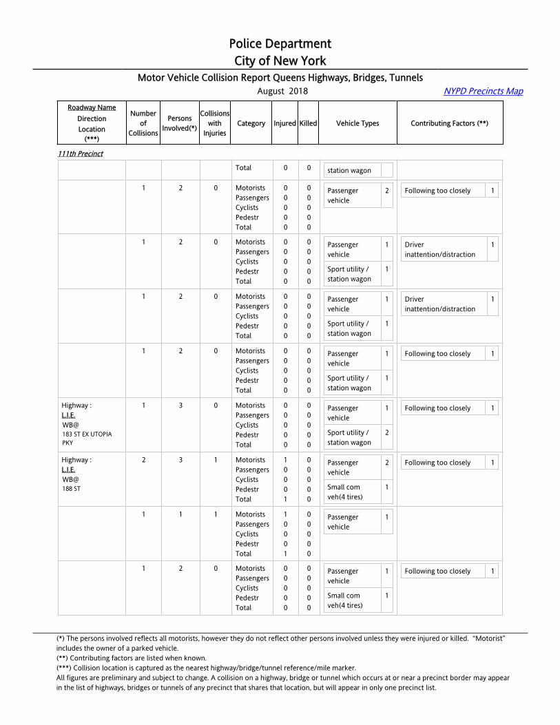
Police DepartmentCity of New York
Motor Vehicle Collision Report Queens Highways, Bridges, Tunnels August 2018 NYPD Precincts Map
Roadway NameDirectionLocation
(***)
Numberof
Collisions
PersonsInvolved(*)
Collisionswith
InjuriesCategory Injured Killed Vehicle Types Contributing Factors (**)
111th Precinct
Total 0 0 station wagon
Highway :[email protected] E/O C.I.P.
1 2 0 MotoristsPassengersCyclistsPedestrTotal
00000
00000
Passenger vehicle
2 Following too closely 1
Highway :[email protected] E/O C.I.P.
1 2 0 MotoristsPassengersCyclistsPedestrTotal
00000
00000
Passenger vehicle
1
Sport utility / station wagon
1
Driver inattention/distraction
1
Highway :[email protected] E/O C.I.P.
1 2 0 MotoristsPassengersCyclistsPedestrTotal
00000
00000
Passenger vehicle
1
Sport utility / station wagon
1
Driver inattention/distraction
1
Highway :[email protected] E/O C.I.P.
1 2 0 MotoristsPassengersCyclistsPedestrTotal
00000
00000
Passenger vehicle
1
Sport utility / station wagon
1
Following too closely 1
Highway :L.I.E.WB@183 ST EX UTOPIA PKY
1 3 0 MotoristsPassengersCyclistsPedestrTotal
00000
00000
Passenger vehicle
1
Sport utility / station wagon
2
Following too closely 1
Highway :L.I.E.WB@188 ST
2 3 1 MotoristsPassengersCyclistsPedestrTotal
10001
00000
Passenger vehicle
2
Small com veh(4 tires)
1
Following too closely 1
Highway :L.I.E.WB@188 ST
1 1 1 MotoristsPassengersCyclistsPedestrTotal
10001
00000
Passenger vehicle
1
Highway :L.I.E.WB@188 ST
1 2 0 MotoristsPassengersCyclistsPedestrTotal
00000
00000
Passenger vehicle
1
Small com veh(4 tires)
1
Following too closely 1
(*) The persons involved reflects all motorists, however they do not reflect other persons involved unless they were injured or killed. “Motorist” includes the owner of a parked vehicle.(**) Contributing factors are listed when known.(***) Collision location is captured as the nearest highway/bridge/tunnel reference/mile marker.All figures are preliminary and subject to change. A collision on a highway, bridge or tunnel which occurs at or near a precinct border may appearin the list of highways, bridges or tunnels of any precinct that shares that location, but will appear in only one precinct list.
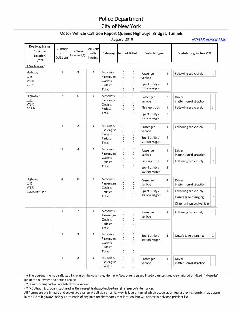
Police DepartmentCity of New York
Motor Vehicle Collision Report Queens Highways, Bridges, Tunnels August 2018 NYPD Precincts Map
Roadway NameDirectionLocation
(***)
Numberof
Collisions
PersonsInvolved(*)
Collisionswith
InjuriesCategory Injured Killed Vehicle Types Contributing Factors (**)
111th Precinct
Highway :L.I.E.WB@230 ST
1 2 0 MotoristsPassengersCyclistsPedestrTotal
00000
00000
Passenger vehicle
1
Sport utility / station wagon
1
Following too closely 1
Highway :L.I.E.WB@BELL BL
2 6 0 MotoristsPassengersCyclistsPedestrTotal
00000
00000
Passenger vehicle
2
Pick-up truck 1
Sport utility / station wagon
3
Driver inattention/distraction
1
Following too closely 3
Highway :L.I.E.WB@BELL BL
1 2 0 MotoristsPassengersCyclistsPedestrTotal
00000
00000
Passenger vehicle
1
Sport utility / station wagon
1
Following too closely 1
Highway :L.I.E.WB@BELL BL
1 4 0 MotoristsPassengersCyclistsPedestrTotal
00000
00000
Passenger vehicle
1
Pick-up truck 1
Sport utility / station wagon
2
Driver inattention/distraction
1
Following too closely 2
Highway :L.I.E.WB@CLEARVIEW EXP
4 8 0 MotoristsPassengersCyclistsPedestrTotal
00000
00000
Passenger vehicle
4
Sport utility / station wagon
4
Driver inattention/distraction
1
Following too closely 1
Unsafe lane changing 2
Other uninvolved vehicle 1
Highway :L.I.E.WB@CLEARVIEW EXP
1 2 0 MotoristsPassengersCyclistsPedestrTotal
00000
00000
Passenger vehicle
2 Following too closely 1
Highway :L.I.E.WB@CLEARVIEW EXP
1 2 0 MotoristsPassengersCyclistsPedestrTotal
00000
00000
Sport utility / station wagon
2 Unsafe lane changing 2
Highway :L.I.E.WB@
1 2 0 MotoristsPassengersCyclists
000
000
Passenger vehicle
1 Driver inattention/distraction
1
(*) The persons involved reflects all motorists, however they do not reflect other persons involved unless they were injured or killed. “Motorist” includes the owner of a parked vehicle.(**) Contributing factors are listed when known.(***) Collision location is captured as the nearest highway/bridge/tunnel reference/mile marker.All figures are preliminary and subject to change. A collision on a highway, bridge or tunnel which occurs at or near a precinct border may appearin the list of highways, bridges or tunnels of any precinct that shares that location, but will appear in only one precinct list.

Police DepartmentCity of New York
Motor Vehicle Collision Report Queens Highways, Bridges, Tunnels August 2018 NYPD Precincts Map
Roadway NameDirectionLocation
(***)
Numberof
Collisions
PersonsInvolved(*)
Collisionswith
InjuriesCategory Injured Killed Vehicle Types Contributing Factors (**)
111th Precinct
CLEARVIEW EXP PedestrTotal
00
00
Sport utility / station wagon
1
Highway :L.I.E.WB@CLEARVIEW EXP
1 2 0 MotoristsPassengersCyclistsPedestrTotal
00000
00000
Passenger vehicle
1
Sport utility / station wagon
1
Other uninvolved vehicle 1
Highway :L.I.E.WB@CLOVERDALE BL
1 2 0 MotoristsPassengersCyclistsPedestrTotal
00000
00000
Sport utility / station wagon
2 Following too closely 1
Highway :L.I.E.WB@CROSS ISLAND PKY
6 19 1 MotoristsPassengersCyclistsPedestrTotal
02002
00000
Large com veh(6 or more tires)
1
Passenger vehicle
7
Pick-up truck 1
Sport utility / station wagon
8
Driver inattention/distraction
4
Following too closely 2
Unsafe lane changing 1
Highway :L.I.E.WB@CROSS ISLAND PKY
1 4 0 MotoristsPassengersCyclistsPedestrTotal
00000
00000
Passenger vehicle
1
Sport utility / station wagon
3
Following too closely 1
Highway :L.I.E.WB@CROSS ISLAND PKY
1 5 1 MotoristsPassengersCyclistsPedestrTotal
02002
00000
Passenger vehicle
1
Sport utility / station wagon
2
Driver inattention/distraction
1
Highway :L.I.E.WB@CROSS ISLAND PKY
1 2 0 MotoristsPassengersCyclistsPedestrTotal
00000
00000
Passenger vehicle
1
Sport utility / station wagon
1
Following too closely 1
Highway :L.I.E.WB@CROSS ISLAND PKY
1 3 0 MotoristsPassengersCyclistsPedestrTotal
00000
00000
Passenger vehicle
1
Sport utility / station wagon
2
Driver inattention/distraction
1
(*) The persons involved reflects all motorists, however they do not reflect other persons involved unless they were injured or killed. “Motorist” includes the owner of a parked vehicle.(**) Contributing factors are listed when known.(***) Collision location is captured as the nearest highway/bridge/tunnel reference/mile marker.All figures are preliminary and subject to change. A collision on a highway, bridge or tunnel which occurs at or near a precinct border may appearin the list of highways, bridges or tunnels of any precinct that shares that location, but will appear in only one precinct list.

Police DepartmentCity of New York
Motor Vehicle Collision Report Queens Highways, Bridges, Tunnels August 2018 NYPD Precincts Map
Roadway NameDirectionLocation
(***)
Numberof
Collisions
PersonsInvolved(*)
Collisionswith
InjuriesCategory Injured Killed Vehicle Types Contributing Factors (**)
111th Precinct
Highway :L.I.E.WB@CROSS ISLAND PKY
1 3 0 MotoristsPassengersCyclistsPedestrTotal
00000
00000
Passenger vehicle
2
Pick-up truck 1
Driver inattention/distraction
2
Highway :L.I.E.WB@CROSS ISLAND PKY
1 2 0 MotoristsPassengersCyclistsPedestrTotal
00000
00000
Large com veh(6 or more tires)
1
Passenger vehicle
1
Unsafe lane changing 1
Highway :L.I.E.WB@FRANCIS LEWIS BL
1 2 1 MotoristsPassengersCyclistsPedestrTotal
10001
00000
Sport utility / station wagon
2 Driver inattention/distraction
1
Highway :L.I.E.WB@LITTLE NECK PKY
2 4 0 MotoristsPassengersCyclistsPedestrTotal
00000
00000
Large com veh(6 or more tires)
1
Passenger vehicle
1
Pick-up truck 1
Sport utility / station wagon
1
Unsafe lane changing 2
Highway :L.I.E.WB@LITTLE NECK PKY
1 2 0 MotoristsPassengersCyclistsPedestrTotal
00000
00000
Large com veh(6 or more tires)
1
Passenger vehicle
1
Unsafe lane changing 1
Highway :L.I.E.WB@LITTLE NECK PKY
1 2 0 MotoristsPassengersCyclistsPedestrTotal
00000
00000
Pick-up truck 1
Sport utility / station wagon
1
Unsafe lane changing 1
Highway :L.I.E.WB@OCEANIA ST
1 2 0 MotoristsPassengersCyclistsPedestrTotal
00000
00000
Passenger vehicle
2 Driver inattention/distraction
1
(*) The persons involved reflects all motorists, however they do not reflect other persons involved unless they were injured or killed. “Motorist” includes the owner of a parked vehicle.(**) Contributing factors are listed when known.(***) Collision location is captured as the nearest highway/bridge/tunnel reference/mile marker.All figures are preliminary and subject to change. A collision on a highway, bridge or tunnel which occurs at or near a precinct border may appearin the list of highways, bridges or tunnels of any precinct that shares that location, but will appear in only one precinct list.
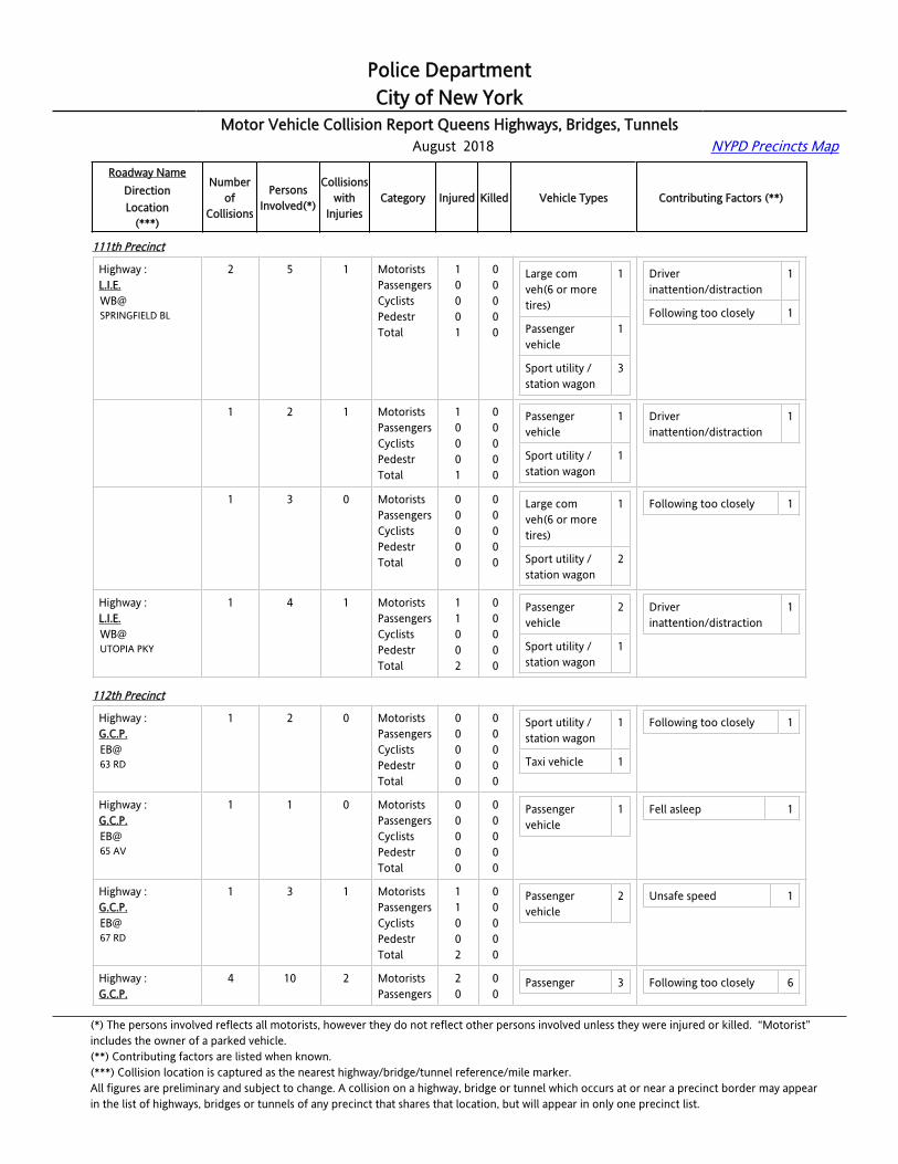
Police DepartmentCity of New York
Motor Vehicle Collision Report Queens Highways, Bridges, Tunnels August 2018 NYPD Precincts Map
Roadway NameDirectionLocation
(***)
Numberof
Collisions
PersonsInvolved(*)
Collisionswith
InjuriesCategory Injured Killed Vehicle Types Contributing Factors (**)
111th Precinct
Highway :L.I.E.WB@SPRINGFIELD BL
2 5 1 MotoristsPassengersCyclistsPedestrTotal
10001
00000
Large com veh(6 or more tires)
1
Passenger vehicle
1
Sport utility / station wagon
3
Driver inattention/distraction
1
Following too closely 1
Highway :L.I.E.WB@SPRINGFIELD BL
1 2 1 MotoristsPassengersCyclistsPedestrTotal
10001
00000
Passenger vehicle
1
Sport utility / station wagon
1
Driver inattention/distraction
1
Highway :L.I.E.WB@SPRINGFIELD BL
1 3 0 MotoristsPassengersCyclistsPedestrTotal
00000
00000
Large com veh(6 or more tires)
1
Sport utility / station wagon
2
Following too closely 1
Highway :L.I.E.WB@UTOPIA PKY
1 4 1 MotoristsPassengersCyclistsPedestrTotal
11002
00000
Passenger vehicle
2
Sport utility / station wagon
1
Driver inattention/distraction
1
112th Precinct
Highway :G.C.P.EB@63 RD
1 2 0 MotoristsPassengersCyclistsPedestrTotal
00000
00000
Sport utility / station wagon
1
Taxi vehicle 1
Following too closely 1
Highway :G.C.P.EB@65 AV
1 1 0 MotoristsPassengersCyclistsPedestrTotal
00000
00000
Passenger vehicle
1 Fell asleep 1
Highway :G.C.P.EB@67 RD
1 3 1 MotoristsPassengersCyclistsPedestrTotal
11002
00000
Passenger vehicle
2 Unsafe speed 1
Highway :G.C.P.
4 10 2 MotoristsPassengers
20
00
Passenger 3 Following too closely 6
(*) The persons involved reflects all motorists, however they do not reflect other persons involved unless they were injured or killed. “Motorist” includes the owner of a parked vehicle.(**) Contributing factors are listed when known.(***) Collision location is captured as the nearest highway/bridge/tunnel reference/mile marker.All figures are preliminary and subject to change. A collision on a highway, bridge or tunnel which occurs at or near a precinct border may appearin the list of highways, bridges or tunnels of any precinct that shares that location, but will appear in only one precinct list.
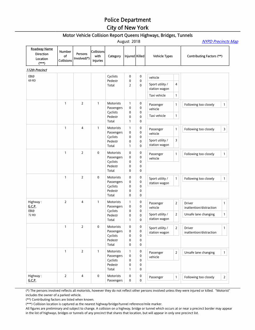
Police DepartmentCity of New York
Motor Vehicle Collision Report Queens Highways, Bridges, Tunnels August 2018 NYPD Precincts Map
Roadway NameDirectionLocation
(***)
Numberof
Collisions
PersonsInvolved(*)
Collisionswith
InjuriesCategory Injured Killed Vehicle Types Contributing Factors (**)
112th Precinct
EB@69 RD
CyclistsPedestrTotal
002
000
vehicle
Sport utility / station wagon
4
Taxi vehicle 1
Highway :G.C.P.EB@69 RD
1 2 1 MotoristsPassengersCyclistsPedestrTotal
10001
00000
Passenger vehicle
1
Taxi vehicle 1
Following too closely 1
Highway :G.C.P.EB@69 RD
1 4 1 MotoristsPassengersCyclistsPedestrTotal
10001
00000
Passenger vehicle
1
Sport utility / station wagon
3
Following too closely 3
Highway :G.C.P.EB@69 RD
1 2 0 MotoristsPassengersCyclistsPedestrTotal
00000
00000
Passenger vehicle
1 Following too closely 1
Highway :G.C.P.EB@69 RD
1 2 0 MotoristsPassengersCyclistsPedestrTotal
00000
00000
Sport utility / station wagon
1 Following too closely 1
Highway :G.C.P.EB@72 RD
2 4 1 MotoristsPassengersCyclistsPedestrTotal
10001
00000
Passenger vehicle
2
Sport utility / station wagon
2
Driver inattention/distraction
1
Unsafe lane changing 1
Highway :G.C.P.EB@72 RD
1 2 0 MotoristsPassengersCyclistsPedestrTotal
00000
00000
Sport utility / station wagon
2 Driver inattention/distraction
1
Highway :G.C.P.EB@72 RD
1 2 1 MotoristsPassengersCyclistsPedestrTotal
10001
00000
Passenger vehicle
2 Unsafe lane changing 1
Highway :G.C.P.
2 4 0 MotoristsPassengers
00
00
Passenger 1 Following too closely 2
(*) The persons involved reflects all motorists, however they do not reflect other persons involved unless they were injured or killed. “Motorist” includes the owner of a parked vehicle.(**) Contributing factors are listed when known.(***) Collision location is captured as the nearest highway/bridge/tunnel reference/mile marker.All figures are preliminary and subject to change. A collision on a highway, bridge or tunnel which occurs at or near a precinct border may appearin the list of highways, bridges or tunnels of any precinct that shares that location, but will appear in only one precinct list.

Police DepartmentCity of New York
Motor Vehicle Collision Report Queens Highways, Bridges, Tunnels August 2018 NYPD Precincts Map
Roadway NameDirectionLocation
(***)
Numberof
Collisions
PersonsInvolved(*)
Collisionswith
InjuriesCategory Injured Killed Vehicle Types Contributing Factors (**)
112th Precinct
EB@75 RD
CyclistsPedestrTotal
000
000
vehicle
Sport utility / station wagon
2
Taxi vehicle 1
Highway :G.C.P.EB@75 RD
1 2 0 MotoristsPassengersCyclistsPedestrTotal
00000
00000
Sport utility / station wagon
2 Following too closely 1
Highway :G.C.P.EB@75 RD
1 2 0 MotoristsPassengersCyclistsPedestrTotal
00000
00000
Passenger vehicle
1
Taxi vehicle 1
Following too closely 1
Highway :G.C.P.EB@76 RD
1 3 0 MotoristsPassengersCyclistsPedestrTotal
00000
00000
Passenger vehicle
2
Sport utility / station wagon
1
Following too closely 2
Highway :G.C.P.EB@78 AV
1 2 1 MotoristsPassengersCyclistsPedestrTotal
10001
00000
Passenger vehicle
1
Sport utility / station wagon
1
Following too closely 1
Highway :G.C.P.EB@JEWEL AV
4 9 1 MotoristsPassengersCyclistsPedestrTotal
10001
00000
Passenger vehicle
6
Sport utility / station wagon
3
Driver inattention/distraction
1
Following too closely 4
Highway :G.C.P.EB@JEWEL AV
1 2 0 MotoristsPassengersCyclistsPedestrTotal
00000
00000
Passenger vehicle
2 Following too closely 1
Highway :G.C.P.EB@JEWEL AV
1 2 0 MotoristsPassengersCyclistsPedestrTotal
00000
00000
Passenger vehicle
2 Driver inattention/distraction
1
Highway :G.C.P.
1 2 1 MotoristsPassengers
10
00
Passenger 2 Following too closely 1
(*) The persons involved reflects all motorists, however they do not reflect other persons involved unless they were injured or killed. “Motorist” includes the owner of a parked vehicle.(**) Contributing factors are listed when known.(***) Collision location is captured as the nearest highway/bridge/tunnel reference/mile marker.All figures are preliminary and subject to change. A collision on a highway, bridge or tunnel which occurs at or near a precinct border may appearin the list of highways, bridges or tunnels of any precinct that shares that location, but will appear in only one precinct list.

Police DepartmentCity of New York
Motor Vehicle Collision Report Queens Highways, Bridges, Tunnels August 2018 NYPD Precincts Map
Roadway NameDirectionLocation
(***)
Numberof
Collisions
PersonsInvolved(*)
Collisionswith
InjuriesCategory Injured Killed Vehicle Types Contributing Factors (**)
112th Precinct
EB@JEWEL AV
CyclistsPedestrTotal
001
000
vehicle
Highway :G.C.P.EB@JEWEL AV
1 3 0 MotoristsPassengersCyclistsPedestrTotal
00000
00000
Sport utility / station wagon
3 Following too closely 2
Highway :G.C.P.EB@UNION TPKE
2 5 0 MotoristsPassengersCyclistsPedestrTotal
00000
00000
Passenger vehicle
3
Sport utility / station wagon
2
Following too closely 1
Unsafe lane changing 2
Highway :G.C.P.EB@UNION TPKE
1 2 0 MotoristsPassengersCyclistsPedestrTotal
00000
00000
Passenger vehicle
1
Sport utility / station wagon
1
Unsafe lane changing 1
Highway :G.C.P.EB@UNION TPKE
1 3 0 MotoristsPassengersCyclistsPedestrTotal
00000
00000
Passenger vehicle
2
Sport utility / station wagon
1
Following too closely 1
Unsafe lane changing 1
Highway :G.C.P.EB@VAN WYCK EXP S/B EX
3 7 0 MotoristsPassengersCyclistsPedestrTotal
00000
00000
Passenger vehicle
3
Sport utility / station wagon
4
Following too closely 2
Unsafe lane changing 2
Highway :G.C.P.EB@VAN WYCK EXP S/B EX
1 2 0 MotoristsPassengersCyclistsPedestrTotal
00000
00000
Passenger vehicle
1
Sport utility / station wagon
1
Unsafe lane changing 1
Highway :G.C.P.EB@VAN WYCK EXP S/B EX
1 2 0 MotoristsPassengersCyclistsPedestrTotal
00000
00000
Sport utility / station wagon
2 Following too closely 1
Unsafe lane changing 1
Highway :G.C.P.EB@VAN WYCK EXP S/B
1 3 0 MotoristsPassengersCyclistsPedestr
0000
0000
Passenger vehicle
2
Sport utility / 1
Following too closely 1
(*) The persons involved reflects all motorists, however they do not reflect other persons involved unless they were injured or killed. “Motorist” includes the owner of a parked vehicle.(**) Contributing factors are listed when known.(***) Collision location is captured as the nearest highway/bridge/tunnel reference/mile marker.All figures are preliminary and subject to change. A collision on a highway, bridge or tunnel which occurs at or near a precinct border may appearin the list of highways, bridges or tunnels of any precinct that shares that location, but will appear in only one precinct list.

Police DepartmentCity of New York
Motor Vehicle Collision Report Queens Highways, Bridges, Tunnels August 2018 NYPD Precincts Map
Roadway NameDirectionLocation
(***)
Numberof
Collisions
PersonsInvolved(*)
Collisionswith
InjuriesCategory Injured Killed Vehicle Types Contributing Factors (**)
112th Precinct
EX Total 0 0 station wagon
Highway :G.C.P.WB@70 RD
1 2 0 MotoristsPassengersCyclistsPedestrTotal
00000
00000
Sport utility / station wagon
1
Taxi vehicle 1
Unsafe lane changing 1
Highway :G.C.P.WB@75 RD
1 2 0 MotoristsPassengersCyclistsPedestrTotal
00000
00000
Sport utility / station wagon
2 Unsafe lane changing 1
Highway :G.C.P.WB@76 RD
1 2 0 MotoristsPassengersCyclistsPedestrTotal
00000
00000
Passenger vehicle
1
Sport utility / station wagon
1
Driver inattention/distraction
2
Highway :G.C.P.WB@78 AV
1 2 0 MotoristsPassengersCyclistsPedestrTotal
00000
00000
Passenger vehicle
2 Driver inattention/distraction
1
Highway :G.C.P.WB@JEWEL AV
1 2 0 MotoristsPassengersCyclistsPedestrTotal
00000
00000
Passenger vehicle
1
Sport utility / station wagon
1
Following too closely 1
Highway :G.C.P.WB@UNION TURNPIKE
3 7 2 MotoristsPassengersCyclistsPedestrTotal
30003
00000
Passenger vehicle
1
Sport utility / station wagon
5
Van 1
Driver inattention/distraction
1
Following too closely 2
Highway :G.C.P.WB@UNION TURNPIKE
1 3 1 MotoristsPassengersCyclistsPedestrTotal
20002
00000
Passenger vehicle
1
Sport utility / station wagon
2
Following too closely 1
Highway :G.C.P.WB@UNION TURNPIKE
1 2 1 MotoristsPassengersCyclistsPedestr
1000
0000
Sport utility / station wagon
1
Van 1
Driver inattention/distraction
1
(*) The persons involved reflects all motorists, however they do not reflect other persons involved unless they were injured or killed. “Motorist” includes the owner of a parked vehicle.(**) Contributing factors are listed when known.(***) Collision location is captured as the nearest highway/bridge/tunnel reference/mile marker.All figures are preliminary and subject to change. A collision on a highway, bridge or tunnel which occurs at or near a precinct border may appearin the list of highways, bridges or tunnels of any precinct that shares that location, but will appear in only one precinct list.

Police DepartmentCity of New York
Motor Vehicle Collision Report Queens Highways, Bridges, Tunnels August 2018 NYPD Precincts Map
Roadway NameDirectionLocation
(***)
Numberof
Collisions
PersonsInvolved(*)
Collisionswith
InjuriesCategory Injured Killed Vehicle Types Contributing Factors (**)
112th Precinct
Total 1 0
Highway :G.C.P.WB@UNION TURNPIKE
1 2 0 MotoristsPassengersCyclistsPedestrTotal
00000
00000
Sport utility / station wagon
2 Following too closely 1
Highway :G.C.P. / JEWEL CDRWB@72 RD
1 3 1 MotoristsPassengersCyclistsPedestrTotal
20002
00000
Passenger vehicle
1
Sport utility / station wagon
1
Taxi vehicle 1
Following too closely 1
Highway :G.C.P. / L.I.E. [email protected]. W/B EN
1 2 0 MotoristsPassengersCyclistsPedestrTotal
00000
00000
Large com veh(6 or more tires)
1
Passenger vehicle
1
Unsafe lane changing 1
Highway :[email protected] E/O 108 ST
3 6 0 MotoristsPassengersCyclistsPedestrTotal
00000
00000
Passenger vehicle
4
Sport utility / station wagon
2
Driver inattention/distraction
2
Following too closely 2
Highway :[email protected] E/O 108 ST
1 2 0 MotoristsPassengersCyclistsPedestrTotal
00000
00000
Passenger vehicle
1
Sport utility / station wagon
1
Following too closely 1
Highway :[email protected] E/O 108 ST
1 2 0 MotoristsPassengersCyclistsPedestrTotal
00000
00000
Passenger vehicle
1
Sport utility / station wagon
1
Following too closely 1
Highway :[email protected] E/O 108 ST
1 2 0 MotoristsPassengersCyclistsPedestrTotal
00000
00000
Passenger vehicle
2 Driver inattention/distraction
2
Highway :[email protected] E/O JUNCTION BL
1 2 0 MotoristsPassengersCyclistsPedestr
0000
0000
Passenger vehicle
1
Sport utility / 1
Driver inattention/distraction
2
(*) The persons involved reflects all motorists, however they do not reflect other persons involved unless they were injured or killed. “Motorist” includes the owner of a parked vehicle.(**) Contributing factors are listed when known.(***) Collision location is captured as the nearest highway/bridge/tunnel reference/mile marker.All figures are preliminary and subject to change. A collision on a highway, bridge or tunnel which occurs at or near a precinct border may appearin the list of highways, bridges or tunnels of any precinct that shares that location, but will appear in only one precinct list.

Police DepartmentCity of New York
Motor Vehicle Collision Report Queens Highways, Bridges, Tunnels August 2018 NYPD Precincts Map
Roadway NameDirectionLocation
(***)
Numberof
Collisions
PersonsInvolved(*)
Collisionswith
InjuriesCategory Injured Killed Vehicle Types Contributing Factors (**)
112th Precinct
Total 0 0 station wagon
Highway :[email protected] W/O WOODHAVEN BL
2 4 0 MotoristsPassengersCyclistsPedestrTotal
00000
00000
Motorcycle 1
Passenger vehicle
1
Sport utility / station wagon
1
Taxi vehicle 1
Driver inattention/distraction
1
Failure to yield right-of-way
1
Highway :[email protected] W/O WOODHAVEN BL
1 2 0 MotoristsPassengersCyclistsPedestrTotal
00000
00000
Motorcycle 1
Taxi vehicle 1
Driver inattention/distraction
1
Highway :[email protected] W/O WOODHAVEN BL
1 2 0 MotoristsPassengersCyclistsPedestrTotal
00000
00000
Passenger vehicle
1
Sport utility / station wagon
1
Failure to yield right-of-way
1
Highway :L.I.E.EB@102 ST
4 15 2 MotoristsPassengersCyclistsPedestrTotal
24006
00000
Passenger vehicle
2
Pick-up truck 2
Sport utility / station wagon
7
Following too closely 8
Other uninvolved vehicle 1
Highway :L.I.E.EB@102 ST
1 2 0 MotoristsPassengersCyclistsPedestrTotal
00000
00000
Passenger vehicle
1
Sport utility / station wagon
1
Following too closely 1
Other uninvolved vehicle 1
Highway :L.I.E.EB@102 ST
1 6 1 MotoristsPassengersCyclistsPedestrTotal
14005
00000
Passenger vehicle
1
Sport utility / station wagon
1
Following too closely 1
Highway :L.I.E.EB@102 ST
1 4 1 MotoristsPassengersCyclistsPedestrTotal
10001
00000
Pick-up truck 1
Sport utility / station wagon
3
Following too closely 4
Highway : 1 3 0 Motorists 0 0 Pick-up truck 1 Following too closely 2
(*) The persons involved reflects all motorists, however they do not reflect other persons involved unless they were injured or killed. “Motorist” includes the owner of a parked vehicle.(**) Contributing factors are listed when known.(***) Collision location is captured as the nearest highway/bridge/tunnel reference/mile marker.All figures are preliminary and subject to change. A collision on a highway, bridge or tunnel which occurs at or near a precinct border may appearin the list of highways, bridges or tunnels of any precinct that shares that location, but will appear in only one precinct list.

Police DepartmentCity of New York
Motor Vehicle Collision Report Queens Highways, Bridges, Tunnels August 2018 NYPD Precincts Map
Roadway NameDirectionLocation
(***)
Numberof
Collisions
PersonsInvolved(*)
Collisionswith
InjuriesCategory Injured Killed Vehicle Types Contributing Factors (**)
112th Precinct
L.I.E.EB@102 ST
PassengersCyclistsPedestrTotal
0000
0000
Sport utility / station wagon
2
Highway :L.I.E.EB@108 ST
5 12 2 MotoristsPassengersCyclistsPedestrTotal
20002
00000
Passenger vehicle
4
Pick-up truck 2
Sport utility / station wagon
4
Taxi vehicle 2
Following too closely 6
Highway :L.I.E.EB@108 ST
1 3 1 MotoristsPassengersCyclistsPedestrTotal
10001
00000
Passenger vehicle
2
Taxi vehicle 1
Following too closely 2
Highway :L.I.E.EB@108 ST
1 2 0 MotoristsPassengersCyclistsPedestrTotal
00000
00000
Passenger vehicle
1
Pick-up truck 1
Highway :L.I.E.EB@108 ST
1 2 0 MotoristsPassengersCyclistsPedestrTotal
00000
00000
Sport utility / station wagon
2 Following too closely 1
Highway :L.I.E.EB@108 ST
1 2 0 MotoristsPassengersCyclistsPedestrTotal
00000
00000
Pick-up truck 1
Sport utility / station wagon
1
Following too closely 1
Highway :L.I.E.EB@108 ST
1 3 1 MotoristsPassengersCyclistsPedestrTotal
10001
00000
Passenger vehicle
1
Sport utility / station wagon
1
Taxi vehicle 1
Following too closely 2
Highway :L.I.E.EB@97 ST ENT RP EB LIE
1 5 1 MotoristsPassengersCyclistsPedestr
0300
0000
Passenger vehicle
2 Following too closely 1
(*) The persons involved reflects all motorists, however they do not reflect other persons involved unless they were injured or killed. “Motorist” includes the owner of a parked vehicle.(**) Contributing factors are listed when known.(***) Collision location is captured as the nearest highway/bridge/tunnel reference/mile marker.All figures are preliminary and subject to change. A collision on a highway, bridge or tunnel which occurs at or near a precinct border may appearin the list of highways, bridges or tunnels of any precinct that shares that location, but will appear in only one precinct list.
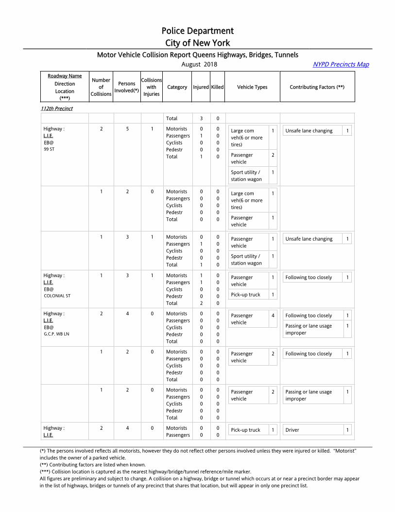
Police DepartmentCity of New York
Motor Vehicle Collision Report Queens Highways, Bridges, Tunnels August 2018 NYPD Precincts Map
Roadway NameDirectionLocation
(***)
Numberof
Collisions
PersonsInvolved(*)
Collisionswith
InjuriesCategory Injured Killed Vehicle Types Contributing Factors (**)
112th Precinct
Total 3 0
Highway :L.I.E.EB@99 ST
2 5 1 MotoristsPassengersCyclistsPedestrTotal
01001
00000
Large com veh(6 or more tires)
1
Passenger vehicle
2
Sport utility / station wagon
1
Unsafe lane changing 1
Highway :L.I.E.EB@99 ST
1 2 0 MotoristsPassengersCyclistsPedestrTotal
00000
00000
Large com veh(6 or more tires)
1
Passenger vehicle
1
Highway :L.I.E.EB@99 ST
1 3 1 MotoristsPassengersCyclistsPedestrTotal
01001
00000
Passenger vehicle
1
Sport utility / station wagon
1
Unsafe lane changing 1
Highway :L.I.E.EB@COLONIAL ST
1 3 1 MotoristsPassengersCyclistsPedestrTotal
11002
00000
Passenger vehicle
1
Pick-up truck 1
Following too closely 1
Highway :[email protected]. WB LN
2 4 0 MotoristsPassengersCyclistsPedestrTotal
00000
00000
Passenger vehicle
4 Following too closely 1
Passing or lane usage improper
1
Highway :[email protected]. WB LN
1 2 0 MotoristsPassengersCyclistsPedestrTotal
00000
00000
Passenger vehicle
2 Following too closely 1
Highway :[email protected]. WB LN
1 2 0 MotoristsPassengersCyclistsPedestrTotal
00000
00000
Passenger vehicle
2 Passing or lane usage improper
1
Highway :L.I.E.
2 4 0 MotoristsPassengers
00
00
Pick-up truck 1 Driver 1
(*) The persons involved reflects all motorists, however they do not reflect other persons involved unless they were injured or killed. “Motorist” includes the owner of a parked vehicle.(**) Contributing factors are listed when known.(***) Collision location is captured as the nearest highway/bridge/tunnel reference/mile marker.All figures are preliminary and subject to change. A collision on a highway, bridge or tunnel which occurs at or near a precinct border may appearin the list of highways, bridges or tunnels of any precinct that shares that location, but will appear in only one precinct list.

Police DepartmentCity of New York
Motor Vehicle Collision Report Queens Highways, Bridges, Tunnels August 2018 NYPD Precincts Map
Roadway NameDirectionLocation
(***)
Numberof
Collisions
PersonsInvolved(*)
Collisionswith
InjuriesCategory Injured Killed Vehicle Types Contributing Factors (**)
112th Precinct
EB@QUEENS BL
CyclistsPedestrTotal
000
000
Sport utility / station wagon
2 inattention/distraction
Unsafe lane changing 1
Highway :L.I.E.EB@QUEENS BL
1 2 0 MotoristsPassengersCyclistsPedestrTotal
00000
00000
Sport utility / station wagon
2 Driver inattention/distraction
1
Highway :L.I.E.EB@QUEENS BL
1 2 0 MotoristsPassengersCyclistsPedestrTotal
00000
00000
Pick-up truck 1 Unsafe lane changing 1
Highway :L.I.E.EB@WOODHAVEN BL
2 4 0 MotoristsPassengersCyclistsPedestrTotal
00000
00000
Large com veh(6 or more tires)
1
Passenger vehicle
2
Small com veh(4 tires)
1
Driver inattention/distraction
1
Failure to yield right-of-way
1
Passing or lane usage improper
1
Highway :L.I.E.EB@WOODHAVEN BL
1 2 0 MotoristsPassengersCyclistsPedestrTotal
00000
00000
Passenger vehicle
1
Small com veh(4 tires)
1
Failure to yield right-of-way
1
Highway :L.I.E.EB@WOODHAVEN BL
1 2 0 MotoristsPassengersCyclistsPedestrTotal
00000
00000
Large com veh(6 or more tires)
1
Passenger vehicle
1
Driver inattention/distraction
1
Passing or lane usage improper
1
Highway :L.I.E.EB@YELLOWSTONE BL
5 12 2 MotoristsPassengersCyclistsPedestrTotal
31004
00000
Large com veh(6 or more tires)
1
Passenger vehicle
6
Sport utility / station wagon
4
Driver inexperience 1
Fell asleep 1
Following too closely 3
Highway :L.I.E.
1 2 0 MotoristsPassengers
00
00
Passenger 1 Following too closely 1
(*) The persons involved reflects all motorists, however they do not reflect other persons involved unless they were injured or killed. “Motorist” includes the owner of a parked vehicle.(**) Contributing factors are listed when known.(***) Collision location is captured as the nearest highway/bridge/tunnel reference/mile marker.All figures are preliminary and subject to change. A collision on a highway, bridge or tunnel which occurs at or near a precinct border may appearin the list of highways, bridges or tunnels of any precinct that shares that location, but will appear in only one precinct list.
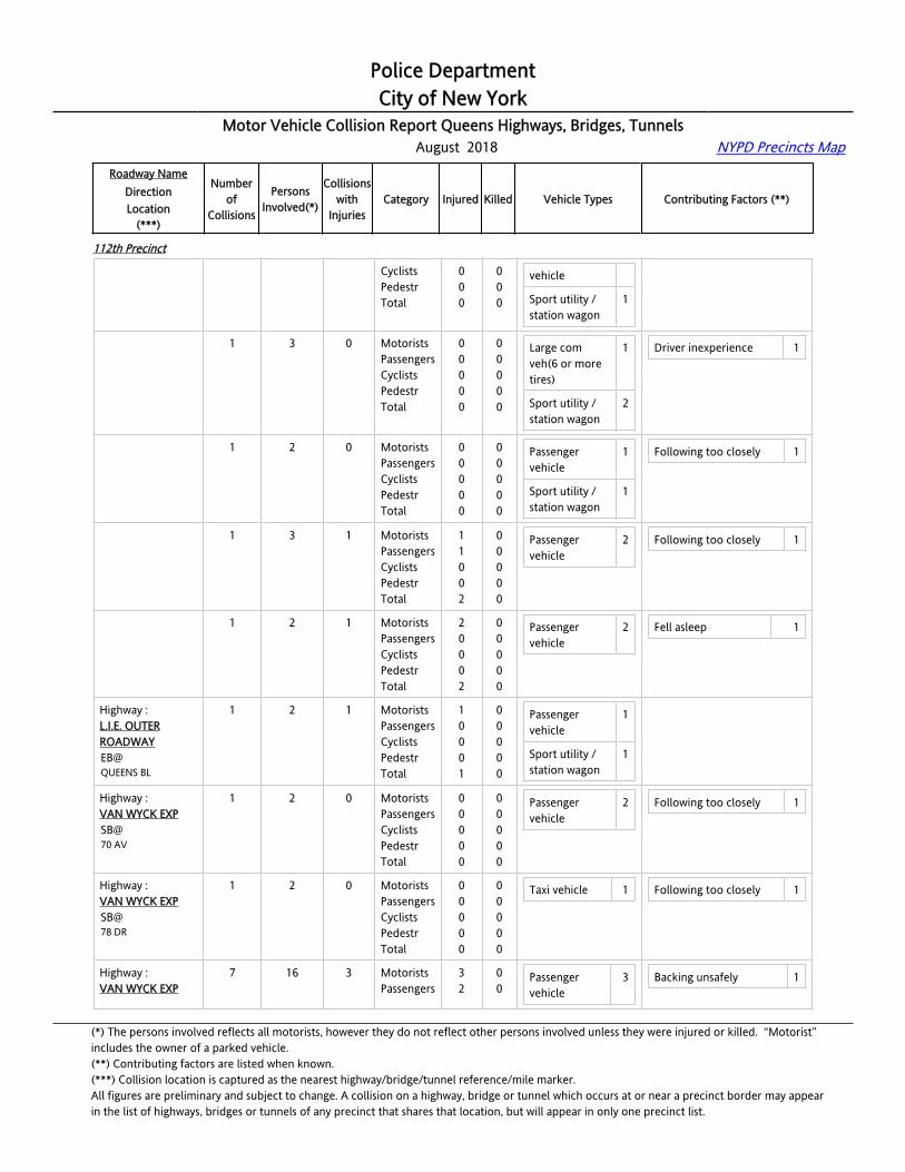
Police DepartmentCity of New York
Motor Vehicle Collision Report Queens Highways, Bridges, Tunnels August 2018 NYPD Precincts Map
Roadway NameDirectionLocation
(***)
Numberof
Collisions
PersonsInvolved(*)
Collisionswith
InjuriesCategory Injured Killed Vehicle Types Contributing Factors (**)
112th Precinct
EB@YELLOWSTONE BL
CyclistsPedestrTotal
000
000
vehicle
Sport utility / station wagon
1
Highway :L.I.E.EB@YELLOWSTONE BL
1 3 0 MotoristsPassengersCyclistsPedestrTotal
00000
00000
Large com veh(6 or more tires)
1
Sport utility / station wagon
2
Driver inexperience 1
Highway :L.I.E.EB@YELLOWSTONE BL
1 2 0 MotoristsPassengersCyclistsPedestrTotal
00000
00000
Passenger vehicle
1
Sport utility / station wagon
1
Following too closely 1
Highway :L.I.E.EB@YELLOWSTONE BL
1 3 1 MotoristsPassengersCyclistsPedestrTotal
11002
00000
Passenger vehicle
2 Following too closely 1
Highway :L.I.E.EB@YELLOWSTONE BL
1 2 1 MotoristsPassengersCyclistsPedestrTotal
20002
00000
Passenger vehicle
2 Fell asleep 1
Highway :L.I.E. OUTER ROADWAYEB@QUEENS BL
1 2 1 MotoristsPassengersCyclistsPedestrTotal
10001
00000
Passenger vehicle
1
Sport utility / station wagon
1
Highway :VAN WYCK EXPSB@70 AV
1 2 0 MotoristsPassengersCyclistsPedestrTotal
00000
00000
Passenger vehicle
2 Following too closely 1
Highway :VAN WYCK EXPSB@78 DR
1 2 0 MotoristsPassengersCyclistsPedestrTotal
00000
00000
Taxi vehicle 1 Following too closely 1
Highway :VAN WYCK EXP
7 16 3 MotoristsPassengers
32
00
Passenger vehicle
3 Backing unsafely 1
(*) The persons involved reflects all motorists, however they do not reflect other persons involved unless they were injured or killed. “Motorist” includes the owner of a parked vehicle.(**) Contributing factors are listed when known.(***) Collision location is captured as the nearest highway/bridge/tunnel reference/mile marker.All figures are preliminary and subject to change. A collision on a highway, bridge or tunnel which occurs at or near a precinct border may appearin the list of highways, bridges or tunnels of any precinct that shares that location, but will appear in only one precinct list.
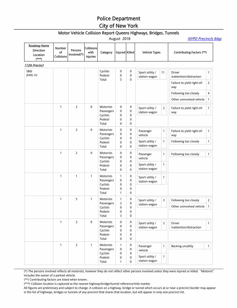
Police DepartmentCity of New York
Motor Vehicle Collision Report Queens Highways, Bridges, Tunnels August 2018 NYPD Precincts Map
Roadway NameDirectionLocation
(***)
Numberof
Collisions
PersonsInvolved(*)
Collisionswith
InjuriesCategory Injured Killed Vehicle Types Contributing Factors (**)
112th Precinct
SB@JEWEL AV
CyclistsPedestrTotal
005
000
Sport utility / station wagon
11 Driver inattention/distraction
1
Failure to yield right-of-way
2
Following too closely 4
Other uninvolved vehicle 1
Highway :VAN WYCK EXPSB@JEWEL AV
1 2 0 MotoristsPassengersCyclistsPedestrTotal
00000
00000
Sport utility / station wagon
2 Failure to yield right-of-way
1
Highway :VAN WYCK EXPSB@JEWEL AV
1 2 0 MotoristsPassengersCyclistsPedestrTotal
00000
00000
Passenger vehicle
1
Sport utility / station wagon
1
Failure to yield right-of-way
1
Following too closely 1
Highway :VAN WYCK EXPSB@JEWEL AV
1 2 0 MotoristsPassengersCyclistsPedestrTotal
00000
00000
Passenger vehicle
1
Sport utility / station wagon
1
Following too closely 1
Highway :VAN WYCK EXPSB@JEWEL AV
1 1 1 MotoristsPassengersCyclistsPedestrTotal
10001
00000
Sport utility / station wagon
1
Highway :VAN WYCK EXPSB@JEWEL AV
1 5 1 MotoristsPassengersCyclistsPedestrTotal
12003
00000
Sport utility / station wagon
3 Following too closely 2
Other uninvolved vehicle 1
Highway :VAN WYCK EXPSB@JEWEL AV
1 2 0 MotoristsPassengersCyclistsPedestrTotal
00000
00000
Sport utility / station wagon
2 Driver inattention/distraction
1
Highway :VAN WYCK EXPSB@JEWEL AV
1 2 1 MotoristsPassengersCyclistsPedestrTotal
10001
00000
Passenger vehicle
1
Sport utility / station wagon
1
Backing unsafely 1
(*) The persons involved reflects all motorists, however they do not reflect other persons involved unless they were injured or killed. “Motorist” includes the owner of a parked vehicle.(**) Contributing factors are listed when known.(***) Collision location is captured as the nearest highway/bridge/tunnel reference/mile marker.All figures are preliminary and subject to change. A collision on a highway, bridge or tunnel which occurs at or near a precinct border may appearin the list of highways, bridges or tunnels of any precinct that shares that location, but will appear in only one precinct list.

Police DepartmentCity of New York
Motor Vehicle Collision Report Queens Highways, Bridges, Tunnels August 2018 NYPD Precincts Map
Roadway NameDirectionLocation
(***)
Numberof
Collisions
PersonsInvolved(*)
Collisionswith
InjuriesCategory Injured Killed Vehicle Types Contributing Factors (**)
113th Precinct
Highway :BELT [email protected] E/O KENNEDY EXP
1 2 0 MotoristsPassengersCyclistsPedestrTotal
00000
00000
Passenger vehicle
1
Sport utility / station wagon
1
Highway :BELT PKYWB@138 ST
1 2 0 MotoristsPassengersCyclistsPedestrTotal
00000
00000
Pick-up truck 2
Highway :BELT PKYWB@150 ST
2 4 1 MotoristsPassengersCyclistsPedestrTotal
10001
00000
Passenger vehicle
1
Pick-up truck 1
Sport utility / station wagon
2
Driver inattention/distraction
2
Highway :BELT PKYWB@150 ST
1 2 1 MotoristsPassengersCyclistsPedestrTotal
10001
00000
Sport utility / station wagon
2 Driver inattention/distraction
1
Highway :BELT PKYWB@150 ST
1 2 0 MotoristsPassengersCyclistsPedestrTotal
00000
00000
Passenger vehicle
1
Pick-up truck 1
Driver inattention/distraction
1
Highway :BELT PKYWB@151 PL
1 2 1 MotoristsPassengersCyclistsPedestrTotal
10001
00000
Passenger vehicle
2
Highway :BELT PKYWB@158 ST
1 2 0 MotoristsPassengersCyclistsPedestrTotal
00000
00000
Passenger vehicle
1
Sport utility / station wagon
1
Driver inattention/distraction
1
Other uninvolved vehicle 1
Highway :BELT PKYWB@181 ST
1 2 0 MotoristsPassengersCyclistsPedestrTotal
00000
00000
Passenger vehicle
2 Following too closely 1
(*) The persons involved reflects all motorists, however they do not reflect other persons involved unless they were injured or killed. “Motorist” includes the owner of a parked vehicle.(**) Contributing factors are listed when known.(***) Collision location is captured as the nearest highway/bridge/tunnel reference/mile marker.All figures are preliminary and subject to change. A collision on a highway, bridge or tunnel which occurs at or near a precinct border may appearin the list of highways, bridges or tunnels of any precinct that shares that location, but will appear in only one precinct list.

Police DepartmentCity of New York
Motor Vehicle Collision Report Queens Highways, Bridges, Tunnels August 2018 NYPD Precincts Map
Roadway NameDirectionLocation
(***)
Numberof
Collisions
PersonsInvolved(*)
Collisionswith
InjuriesCategory Injured Killed Vehicle Types Contributing Factors (**)
113th Precinct
Highway :BELT PKYWB@183 ST
1 3 0 MotoristsPassengersCyclistsPedestrTotal
00000
00000
Passenger vehicle
3 Driver inattention/distraction
1
Highway :BELT PKYWB@CRANSTON ST
1 3 1 MotoristsPassengersCyclistsPedestrTotal
21003
00000
Passenger vehicle
1
Sport utility / station wagon
1
Passing or lane usage improper
1
Highway :BELT PKYWB@FARMERS BL
3 8 0 MotoristsPassengersCyclistsPedestrTotal
00000
00000
Passenger vehicle
3
Sport utility / station wagon
4
Driver inattention/distraction
2
Following too closely 1
Highway :BELT PKYWB@FARMERS BL
1 3 0 MotoristsPassengersCyclistsPedestrTotal
00000
00000
Passenger vehicle
1
Sport utility / station wagon
2
Following too closely 1
Highway :BELT PKYWB@FARMERS BL
1 3 0 MotoristsPassengersCyclistsPedestrTotal
00000
00000
Passenger vehicle
1
Sport utility / station wagon
1
Driver inattention/distraction
1
Highway :BELT PKYWB@FARMERS BL
1 2 0 MotoristsPassengersCyclistsPedestrTotal
00000
00000
Passenger vehicle
1
Sport utility / station wagon
1
Driver inattention/distraction
1
Highway :BELT PKYWB@KENNEDY EXP
1 2 0 MotoristsPassengersCyclistsPedestrTotal
00000
00000
Passenger vehicle
1
Pick-up truck 1
Driver inattention/distraction
1
Highway :BELT PKYWB@ROCKAWAY BL
2 4 0 MotoristsPassengersCyclistsPedestrTotal
00000
00000
Passenger vehicle
4 Driver inattention/distraction
2
Following too closely 1
Highway :BELT PKY
1 2 0 MotoristsPassengers
00
00
Passenger vehicle
2 Driver inattention/distraction
2
(*) The persons involved reflects all motorists, however they do not reflect other persons involved unless they were injured or killed. “Motorist” includes the owner of a parked vehicle.(**) Contributing factors are listed when known.(***) Collision location is captured as the nearest highway/bridge/tunnel reference/mile marker.All figures are preliminary and subject to change. A collision on a highway, bridge or tunnel which occurs at or near a precinct border may appearin the list of highways, bridges or tunnels of any precinct that shares that location, but will appear in only one precinct list.
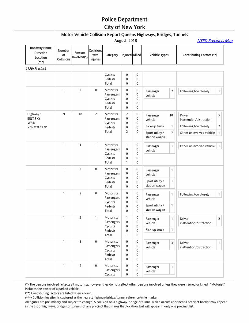
Police DepartmentCity of New York
Motor Vehicle Collision Report Queens Highways, Bridges, Tunnels August 2018 NYPD Precincts Map
Roadway NameDirectionLocation
(***)
Numberof
Collisions
PersonsInvolved(*)
Collisionswith
InjuriesCategory Injured Killed Vehicle Types Contributing Factors (**)
113th Precinct
WB@ROCKAWAY BL
CyclistsPedestrTotal
000
000
Highway :BELT PKYWB@ROCKAWAY BL
1 2 0 MotoristsPassengersCyclistsPedestrTotal
00000
00000
Passenger vehicle
2 Following too closely 1
Highway :BELT PKYWB@VAN WYCK EXP
9 18 2 MotoristsPassengersCyclistsPedestrTotal
20002
00000
Passenger vehicle
10
Pick-up truck 1
Sport utility / station wagon
7
Driver inattention/distraction
5
Following too closely 2
Other uninvolved vehicle 1
Highway :BELT PKYWB@VAN WYCK EXP
1 1 1 MotoristsPassengersCyclistsPedestrTotal
10001
00000
Passenger vehicle
1 Other uninvolved vehicle 1
Highway :BELT PKYWB@VAN WYCK EXP
1 2 0 MotoristsPassengersCyclistsPedestrTotal
00000
00000
Passenger vehicle
1
Sport utility / station wagon
1
Highway :BELT PKYWB@VAN WYCK EXP
1 2 0 MotoristsPassengersCyclistsPedestrTotal
00000
00000
Passenger vehicle
1
Sport utility / station wagon
1
Following too closely 1
Highway :BELT PKYWB@VAN WYCK EXP
1 2 1 MotoristsPassengersCyclistsPedestrTotal
10001
00000
Passenger vehicle
1
Pick-up truck 1
Driver inattention/distraction
2
Highway :BELT PKYWB@VAN WYCK EXP
1 3 0 MotoristsPassengersCyclistsPedestrTotal
00000
00000
Passenger vehicle
3 Driver inattention/distraction
1
Highway :BELT PKYWB@
1 2 0 MotoristsPassengersCyclists
000
000
Passenger vehicle
1
(*) The persons involved reflects all motorists, however they do not reflect other persons involved unless they were injured or killed. “Motorist” includes the owner of a parked vehicle.(**) Contributing factors are listed when known.(***) Collision location is captured as the nearest highway/bridge/tunnel reference/mile marker.All figures are preliminary and subject to change. A collision on a highway, bridge or tunnel which occurs at or near a precinct border may appearin the list of highways, bridges or tunnels of any precinct that shares that location, but will appear in only one precinct list.
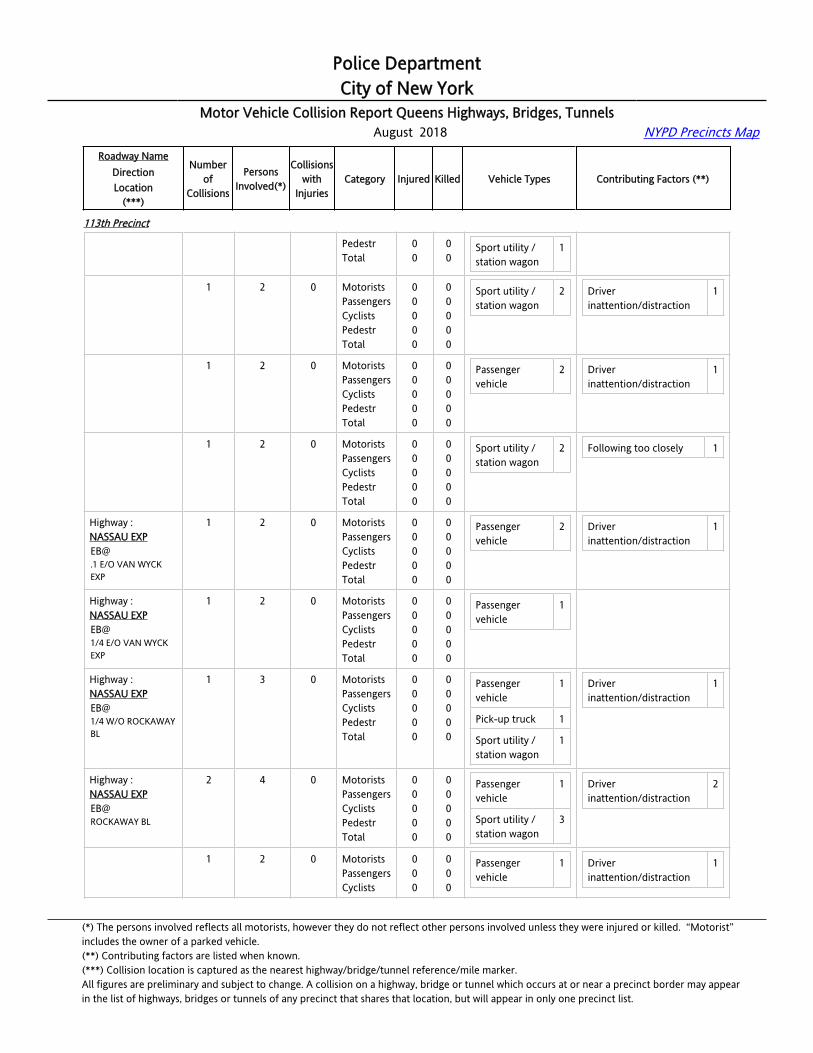
Police DepartmentCity of New York
Motor Vehicle Collision Report Queens Highways, Bridges, Tunnels August 2018 NYPD Precincts Map
Roadway NameDirectionLocation
(***)
Numberof
Collisions
PersonsInvolved(*)
Collisionswith
InjuriesCategory Injured Killed Vehicle Types Contributing Factors (**)
113th Precinct
VAN WYCK EXP PedestrTotal
00
00
Sport utility / station wagon
1
Highway :BELT PKYWB@VAN WYCK EXP
1 2 0 MotoristsPassengersCyclistsPedestrTotal
00000
00000
Sport utility / station wagon
2 Driver inattention/distraction
1
Highway :BELT PKYWB@VAN WYCK EXP
1 2 0 MotoristsPassengersCyclistsPedestrTotal
00000
00000
Passenger vehicle
2 Driver inattention/distraction
1
Highway :BELT PKYWB@VAN WYCK EXP
1 2 0 MotoristsPassengersCyclistsPedestrTotal
00000
00000
Sport utility / station wagon
2 Following too closely 1
Highway :NASSAU [email protected] E/O VAN WYCK EXP
1 2 0 MotoristsPassengersCyclistsPedestrTotal
00000
00000
Passenger vehicle
2 Driver inattention/distraction
1
Highway :NASSAU EXPEB@1/4 E/O VAN WYCK EXP
1 2 0 MotoristsPassengersCyclistsPedestrTotal
00000
00000
Passenger vehicle
1
Highway :NASSAU EXPEB@1/4 W/O ROCKAWAY BL
1 3 0 MotoristsPassengersCyclistsPedestrTotal
00000
00000
Passenger vehicle
1
Pick-up truck 1
Sport utility / station wagon
1
Driver inattention/distraction
1
Highway :NASSAU EXPEB@ROCKAWAY BL
2 4 0 MotoristsPassengersCyclistsPedestrTotal
00000
00000
Passenger vehicle
1
Sport utility / station wagon
3
Driver inattention/distraction
2
Highway :NASSAU EXPEB@
1 2 0 MotoristsPassengersCyclists
000
000
Passenger vehicle
1 Driver inattention/distraction
1
(*) The persons involved reflects all motorists, however they do not reflect other persons involved unless they were injured or killed. “Motorist” includes the owner of a parked vehicle.(**) Contributing factors are listed when known.(***) Collision location is captured as the nearest highway/bridge/tunnel reference/mile marker.All figures are preliminary and subject to change. A collision on a highway, bridge or tunnel which occurs at or near a precinct border may appearin the list of highways, bridges or tunnels of any precinct that shares that location, but will appear in only one precinct list.
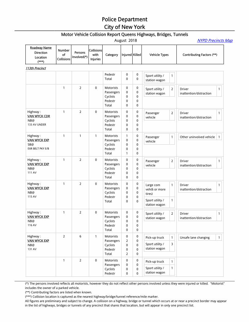
Police DepartmentCity of New York
Motor Vehicle Collision Report Queens Highways, Bridges, Tunnels August 2018 NYPD Precincts Map
Roadway NameDirectionLocation
(***)
Numberof
Collisions
PersonsInvolved(*)
Collisionswith
InjuriesCategory Injured Killed Vehicle Types Contributing Factors (**)
113th Precinct
ROCKAWAY BL PedestrTotal
00
00
Sport utility / station wagon
1
Highway :NASSAU EXPEB@ROCKAWAY BL
1 2 0 MotoristsPassengersCyclistsPedestrTotal
00000
00000
Sport utility / station wagon
2 Driver inattention/distraction
1
Highway :VAN WYCK CDRNB@133 AV UNDER
1 2 0 MotoristsPassengersCyclistsPedestrTotal
00000
00000
Passenger vehicle
2 Driver inattention/distraction
1
Highway :VAN WYCK EXPSB@EXR BELT PKY E/B
1 1 1 MotoristsPassengersCyclistsPedestrTotal
10001
00000
Passenger vehicle
1 Other uninvolved vehicle 1
Highway :VAN WYCK EXPNB@111 AV
1 2 0 MotoristsPassengersCyclistsPedestrTotal
00000
00000
Passenger vehicle
2 Driver inattention/distraction
1
Highway :VAN WYCK EXPNB@115 AV
1 2 0 MotoristsPassengersCyclistsPedestrTotal
00000
00000
Large com veh(6 or more tires)
1
Sport utility / station wagon
1
Driver inattention/distraction
1
Highway :VAN WYCK EXPNB@116 AV
1 2 0 MotoristsPassengersCyclistsPedestrTotal
00000
00000
Sport utility / station wagon
2 Driver inattention/distraction
1
Highway :VAN WYCK EXPNB@131 AV
2 6 1 MotoristsPassengersCyclistsPedestrTotal
02002
00000
Pick-up truck 1
Sport utility / station wagon
3
Unsafe lane changing 1
Highway :VAN WYCK EXPNB@131 AV
1 2 0 MotoristsPassengersCyclistsPedestr
0000
0000
Pick-up truck 1
Sport utility / station wagon
1
(*) The persons involved reflects all motorists, however they do not reflect other persons involved unless they were injured or killed. “Motorist” includes the owner of a parked vehicle.(**) Contributing factors are listed when known.(***) Collision location is captured as the nearest highway/bridge/tunnel reference/mile marker.All figures are preliminary and subject to change. A collision on a highway, bridge or tunnel which occurs at or near a precinct border may appearin the list of highways, bridges or tunnels of any precinct that shares that location, but will appear in only one precinct list.
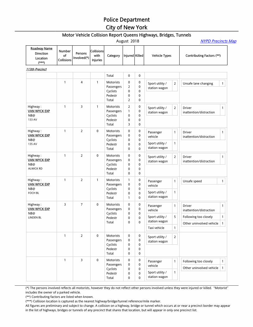
Police DepartmentCity of New York
Motor Vehicle Collision Report Queens Highways, Bridges, Tunnels August 2018 NYPD Precincts Map
Roadway NameDirectionLocation
(***)
Numberof
Collisions
PersonsInvolved(*)
Collisionswith
InjuriesCategory Injured Killed Vehicle Types Contributing Factors (**)
113th Precinct
Total 0 0
Highway :VAN WYCK EXPNB@131 AV
1 4 1 MotoristsPassengersCyclistsPedestrTotal
02002
00000
Sport utility / station wagon
2 Unsafe lane changing 1
Highway :VAN WYCK EXPNB@133 AV
1 3 1 MotoristsPassengersCyclistsPedestrTotal
21003
00000
Sport utility / station wagon
2 Driver inattention/distraction
1
Highway :VAN WYCK EXPNB@135 AV
1 2 0 MotoristsPassengersCyclistsPedestrTotal
00000
00000
Passenger vehicle
1
Sport utility / station wagon
1
Driver inattention/distraction
1
Highway :VAN WYCK EXPNB@ALWICK RD
1 2 0 MotoristsPassengersCyclistsPedestrTotal
00000
00000
Sport utility / station wagon
2 Driver inattention/distraction
1
Highway :VAN WYCK EXPNB@FOCH BL
1 2 1 MotoristsPassengersCyclistsPedestrTotal
10001
00000
Passenger vehicle
1
Sport utility / station wagon
1
Unsafe speed 1
Highway :VAN WYCK EXPNB@LINDEN BL
3 7 0 MotoristsPassengersCyclistsPedestrTotal
00000
00000
Passenger vehicle
1
Sport utility / station wagon
5
Taxi vehicle 1
Driver inattention/distraction
1
Following too closely 1
Other uninvolved vehicle 1
Highway :VAN WYCK EXPNB@LINDEN BL
1 2 0 MotoristsPassengersCyclistsPedestrTotal
00000
00000
Sport utility / station wagon
2
Highway :VAN WYCK EXPNB@LINDEN BL
1 3 0 MotoristsPassengersCyclistsPedestrTotal
00000
00000
Passenger vehicle
1
Sport utility / station wagon
1
Following too closely 1
Other uninvolved vehicle 1
(*) The persons involved reflects all motorists, however they do not reflect other persons involved unless they were injured or killed. “Motorist” includes the owner of a parked vehicle.(**) Contributing factors are listed when known.(***) Collision location is captured as the nearest highway/bridge/tunnel reference/mile marker.All figures are preliminary and subject to change. A collision on a highway, bridge or tunnel which occurs at or near a precinct border may appearin the list of highways, bridges or tunnels of any precinct that shares that location, but will appear in only one precinct list.

Police DepartmentCity of New York
Motor Vehicle Collision Report Queens Highways, Bridges, Tunnels August 2018 NYPD Precincts Map
Roadway NameDirectionLocation
(***)
Numberof
Collisions
PersonsInvolved(*)
Collisionswith
InjuriesCategory Injured Killed Vehicle Types Contributing Factors (**)
113th Precinct
Taxi vehicle 1
Highway :VAN WYCK EXPNB@LINDEN BL
1 2 0 MotoristsPassengersCyclistsPedestrTotal
00000
00000
Sport utility / station wagon
2 Driver inattention/distraction
1
Highway :VAN WYCK EXPNB@ROCKAWAY BL
5 11 0 MotoristsPassengersCyclistsPedestrTotal
00000
00000
Bus 1
Large com veh(6 or more tires)
2
Passenger vehicle
4
Sport utility / station wagon
4
Alcohol involvement 1
Driver inattention/distraction
6
Failure to yield right-of-way
1
Highway :VAN WYCK EXPNB@ROCKAWAY BL
1 2 0 MotoristsPassengersCyclistsPedestrTotal
00000
00000
Passenger vehicle
2 Driver inattention/distraction
2
Highway :VAN WYCK EXPNB@ROCKAWAY BL
1 2 0 MotoristsPassengersCyclistsPedestrTotal
00000
00000
Sport utility / station wagon
2 Driver inattention/distraction
1
Highway :VAN WYCK EXPNB@ROCKAWAY BL
1 2 0 MotoristsPassengersCyclistsPedestrTotal
00000
00000
Large com veh(6 or more tires)
1
Sport utility / station wagon
1
Alcohol involvement 1
Failure to yield right-of-way
1
Highway :VAN WYCK EXPNB@ROCKAWAY BL
1 2 0 MotoristsPassengersCyclistsPedestrTotal
00000
00000
Large com veh(6 or more tires)
1
Passenger vehicle
1
Driver inattention/distraction
2
Highway :VAN WYCK EXPNB@ROCKAWAY BL
1 3 0 MotoristsPassengersCyclistsPedestr
0000
0000
Bus 1
Passenger vehicle
1
Driver inattention/distraction
1
(*) The persons involved reflects all motorists, however they do not reflect other persons involved unless they were injured or killed. “Motorist” includes the owner of a parked vehicle.(**) Contributing factors are listed when known.(***) Collision location is captured as the nearest highway/bridge/tunnel reference/mile marker.All figures are preliminary and subject to change. A collision on a highway, bridge or tunnel which occurs at or near a precinct border may appearin the list of highways, bridges or tunnels of any precinct that shares that location, but will appear in only one precinct list.

Police DepartmentCity of New York
Motor Vehicle Collision Report Queens Highways, Bridges, Tunnels August 2018 NYPD Precincts Map
Roadway NameDirectionLocation
(***)
Numberof
Collisions
PersonsInvolved(*)
Collisionswith
InjuriesCategory Injured Killed Vehicle Types Contributing Factors (**)
113th Precinct
Total 0 0 Sport utility / station wagon
1
Highway :VAN WYCK EXPNB@SUTTER AV
1 2 0 MotoristsPassengersCyclistsPedestrTotal
00000
00000
Passenger vehicle
2 Alcohol involvement 1
Highway :VAN WYCK EXPSB@BELT PKY
2 4 0 MotoristsPassengersCyclistsPedestrTotal
00000
00000
Passenger vehicle
3
Sport utility / station wagon
1
Following too closely 1
Passing or lane usage improper
1
Highway :VAN WYCK EXPSB@BELT PKY
1 2 0 MotoristsPassengersCyclistsPedestrTotal
00000
00000
Passenger vehicle
2 Passing or lane usage improper
1
Highway :VAN WYCK EXPSB@BELT PKY
1 2 0 MotoristsPassengersCyclistsPedestrTotal
00000
00000
Passenger vehicle
1
Sport utility / station wagon
1
Following too closely 1
Highway :VAN WYCK EXPSB@FOCH BL
1 2 0 MotoristsPassengersCyclistsPedestrTotal
00000
00000
Pick-up truck 1
Sport utility / station wagon
1
Highway :VAN WYCK EXPSB@LINDEN BL
2 4 0 MotoristsPassengersCyclistsPedestrTotal
00000
00000
Pick-up truck 1
Sport utility / station wagon
3
Driver inattention/distraction
1
Passing or lane usage improper
1
Highway :VAN WYCK EXPSB@LINDEN BL
1 2 0 MotoristsPassengersCyclistsPedestrTotal
00000
00000
Pick-up truck 1
Sport utility / station wagon
1
Passing or lane usage improper
1
Highway :VAN WYCK EXPSB@LINDEN BL
1 2 0 MotoristsPassengersCyclistsPedestrTotal
00000
00000
Sport utility / station wagon
2 Driver inattention/distraction
1
(*) The persons involved reflects all motorists, however they do not reflect other persons involved unless they were injured or killed. “Motorist” includes the owner of a parked vehicle.(**) Contributing factors are listed when known.(***) Collision location is captured as the nearest highway/bridge/tunnel reference/mile marker.All figures are preliminary and subject to change. A collision on a highway, bridge or tunnel which occurs at or near a precinct border may appearin the list of highways, bridges or tunnels of any precinct that shares that location, but will appear in only one precinct list.

Police DepartmentCity of New York
Motor Vehicle Collision Report Queens Highways, Bridges, Tunnels August 2018 NYPD Precincts Map
Roadway NameDirectionLocation
(***)
Numberof
Collisions
PersonsInvolved(*)
Collisionswith
InjuriesCategory Injured Killed Vehicle Types Contributing Factors (**)
113th Precinct
Highway :VAN WYCK EXPSB@NASSAU EXP
2 4 0 MotoristsPassengersCyclistsPedestrTotal
00000
00000
Passenger vehicle
2
Sport utility / station wagon
2
Unsafe lane changing 1
Highway :VAN WYCK EXPSB@NASSAU EXP
1 2 0 MotoristsPassengersCyclistsPedestrTotal
00000
00000
Passenger vehicle
2
Highway :VAN WYCK EXPSB@NASSAU EXP
1 2 0 MotoristsPassengersCyclistsPedestrTotal
00000
00000
Sport utility / station wagon
2 Unsafe lane changing 1
114th Precinct
Highway :[email protected] E/O 30 AV
1 2 1 MotoristsPassengersCyclistsPedestrTotal
10001
00000
Passenger vehicle
2 Aggressive driving/road rage
1
Highway :[email protected] W/O 30 AV
1 2 0 MotoristsPassengersCyclistsPedestrTotal
00000
00000
Sport utility / station wagon
2
Highway :B.Q.E.EB@49 ST
2 4 0 MotoristsPassengersCyclistsPedestrTotal
00000
00000
Large com veh(6 or more tires)
1
Passenger vehicle
2
Sport utility / station wagon
1
Following too closely 2
Highway :B.Q.E.EB@49 ST
1 2 0 MotoristsPassengersCyclistsPedestrTotal
00000
00000
Large com veh(6 or more tires)
1
Passenger vehicle
1
Following too closely 1
Highway :B.Q.E.
1 2 0 MotoristsPassengers
00
00
Passenger 1 Following too closely 1
(*) The persons involved reflects all motorists, however they do not reflect other persons involved unless they were injured or killed. “Motorist” includes the owner of a parked vehicle.(**) Contributing factors are listed when known.(***) Collision location is captured as the nearest highway/bridge/tunnel reference/mile marker.All figures are preliminary and subject to change. A collision on a highway, bridge or tunnel which occurs at or near a precinct border may appearin the list of highways, bridges or tunnels of any precinct that shares that location, but will appear in only one precinct list.

Police DepartmentCity of New York
Motor Vehicle Collision Report Queens Highways, Bridges, Tunnels August 2018 NYPD Precincts Map
Roadway NameDirectionLocation
(***)
Numberof
Collisions
PersonsInvolved(*)
Collisionswith
InjuriesCategory Injured Killed Vehicle Types Contributing Factors (**)
114th Precinct
EB@49 ST
CyclistsPedestrTotal
000
000
vehicle
Sport utility / station wagon
1
Highway :[email protected] E/O 30 AV
2 4 1 MotoristsPassengersCyclistsPedestrTotal
10001
00000
Passenger vehicle
2
Sport utility / station wagon
1
Taxi vehicle 1
Driver inattention/distraction
1
Unsafe lane changing 1
Highway :[email protected] E/O 30 AV
1 2 0 MotoristsPassengersCyclistsPedestrTotal
00000
00000
Passenger vehicle
2 Unsafe lane changing 1
Highway :[email protected] E/O 30 AV
1 2 1 MotoristsPassengersCyclistsPedestrTotal
10001
00000
Sport utility / station wagon
1
Taxi vehicle 1
Driver inattention/distraction
1
Highway :[email protected] E/O NORTHERN BL
1 2 0 MotoristsPassengersCyclistsPedestrTotal
00000
00000
Sport utility / station wagon
2 Driver inattention/distraction
1
Highway :B.Q.E.WB@ASTORIA BL S
3 6 1 MotoristsPassengersCyclistsPedestrTotal
20002
00000
Passenger vehicle
1
Sport utility / station wagon
4
Taxi vehicle 1
Driver inattention/distraction
1
Following too closely 2
Highway :B.Q.E.WB@ASTORIA BL S
1 2 1 MotoristsPassengersCyclistsPedestrTotal
20002
00000
Sport utility / station wagon
2 Following too closely 1
Highway :B.Q.E.WB@ASTORIA BL S
1 2 0 MotoristsPassengersCyclistsPedestrTotal
00000
00000
Sport utility / station wagon
2 Following too closely 1
(*) The persons involved reflects all motorists, however they do not reflect other persons involved unless they were injured or killed. “Motorist” includes the owner of a parked vehicle.(**) Contributing factors are listed when known.(***) Collision location is captured as the nearest highway/bridge/tunnel reference/mile marker.All figures are preliminary and subject to change. A collision on a highway, bridge or tunnel which occurs at or near a precinct border may appearin the list of highways, bridges or tunnels of any precinct that shares that location, but will appear in only one precinct list.

Police DepartmentCity of New York
Motor Vehicle Collision Report Queens Highways, Bridges, Tunnels August 2018 NYPD Precincts Map
Roadway NameDirectionLocation
(***)
Numberof
Collisions
PersonsInvolved(*)
Collisionswith
InjuriesCategory Injured Killed Vehicle Types Contributing Factors (**)
114th Precinct
Highway :B.Q.E.WB@ASTORIA BL S
1 2 0 MotoristsPassengersCyclistsPedestrTotal
00000
00000
Passenger vehicle
1
Taxi vehicle 1
Driver inattention/distraction
1
Highway :B.Q.E. EAST SPURWB@31 ST
1 3 0 MotoristsPassengersCyclistsPedestrTotal
00000
00000
Sport utility / station wagon
2
Taxi vehicle 1
Following too closely 2
Other uninvolved vehicle 1
Highway :[email protected] E/O 31 ST
1 2 0 MotoristsPassengersCyclistsPedestrTotal
00000
00000
Sport utility / station wagon
2 Driver inattention/distraction
2
Highway :G.C.P.EB@31 ST
1 2 0 MotoristsPassengersCyclistsPedestrTotal
00000
00000
Passenger vehicle
2 Driver inattention/distraction
2
Highway :G.C.P.EB@37 ST
1 2 0 MotoristsPassengersCyclistsPedestrTotal
00000
00000
Passenger vehicle
1
Sport utility / station wagon
1
Highway :G.C.P.EB@49 ST
1 2 0 MotoristsPassengersCyclistsPedestrTotal
00000
00000
Passenger vehicle
1
Taxi vehicle 1
Unsafe lane changing 1
Highway :G.C.P.EB@BROOKLYN QUEENS EXP
1 2 0 MotoristsPassengersCyclistsPedestrTotal
00000
00000
Large com veh(6 or more tires)
1
Passenger vehicle
1
Highway :G.C.P.WB@31 ST
2 6 1 MotoristsPassengersCyclistsPedestrTotal
11002
00000
Pick-up truck 1
Sport utility / station wagon
2
Taxi vehicle 2
Following too closely 1
Unsafe lane changing 1
Other uninvolved vehicle 1
(*) The persons involved reflects all motorists, however they do not reflect other persons involved unless they were injured or killed. “Motorist” includes the owner of a parked vehicle.(**) Contributing factors are listed when known.(***) Collision location is captured as the nearest highway/bridge/tunnel reference/mile marker.All figures are preliminary and subject to change. A collision on a highway, bridge or tunnel which occurs at or near a precinct border may appearin the list of highways, bridges or tunnels of any precinct that shares that location, but will appear in only one precinct list.

Police DepartmentCity of New York
Motor Vehicle Collision Report Queens Highways, Bridges, Tunnels August 2018 NYPD Precincts Map
Roadway NameDirectionLocation
(***)
Numberof
Collisions
PersonsInvolved(*)
Collisionswith
InjuriesCategory Injured Killed Vehicle Types Contributing Factors (**)
114th Precinct
Highway :G.C.P.WB@31 ST
1 2 0 MotoristsPassengersCyclistsPedestrTotal
00000
00000
Pick-up truck 1
Taxi vehicle 1
Following too closely 1
Other uninvolved vehicle 1
Highway :G.C.P.WB@31 ST
1 4 1 MotoristsPassengersCyclistsPedestrTotal
11002
00000
Sport utility / station wagon
2
Taxi vehicle 1
Unsafe lane changing 1
Highway :G.C.P.WB@33 ST
1 2 0 MotoristsPassengersCyclistsPedestrTotal
00000
00000
Sport utility / station wagon
2 Following too closely 1
Highway :G.C.P.WB@43 ST
1 3 1 MotoristsPassengersCyclistsPedestrTotal
01001
00000
Sport utility / station wagon
2
Highway :G.C.P.WB@47 ST
3 6 1 MotoristsPassengersCyclistsPedestrTotal
10001
00000
Passenger vehicle
3
Taxi vehicle 2
Following too closely 2
Highway :G.C.P.WB@47 ST
1 2 1 MotoristsPassengersCyclistsPedestrTotal
10001
00000
Passenger vehicle
1
Highway :G.C.P.WB@47 ST
1 2 0 MotoristsPassengersCyclistsPedestrTotal
00000
00000
Passenger vehicle
2 Following too closely 1
Highway :G.C.P.WB@47 ST
1 2 0 MotoristsPassengersCyclistsPedestrTotal
00000
00000
Taxi vehicle 2 Following too closely 1
Highway :G.C.P.
1 2 0 MotoristsPassengers
00
00
Passenger vehicle
1 Failure to yield right-of-way
1
(*) The persons involved reflects all motorists, however they do not reflect other persons involved unless they were injured or killed. “Motorist” includes the owner of a parked vehicle.(**) Contributing factors are listed when known.(***) Collision location is captured as the nearest highway/bridge/tunnel reference/mile marker.All figures are preliminary and subject to change. A collision on a highway, bridge or tunnel which occurs at or near a precinct border may appearin the list of highways, bridges or tunnels of any precinct that shares that location, but will appear in only one precinct list.

Police DepartmentCity of New York
Motor Vehicle Collision Report Queens Highways, Bridges, Tunnels August 2018 NYPD Precincts Map
Roadway NameDirectionLocation
(***)
Numberof
Collisions
PersonsInvolved(*)
Collisionswith
InjuriesCategory Injured Killed Vehicle Types Contributing Factors (**)
114th Precinct
WB@49 ST
CyclistsPedestrTotal
000
000
Pick-up truck 1 Passing or lane usage improper
1
Highway :G.C.P.WB@74 ST
1 2 0 MotoristsPassengersCyclistsPedestrTotal
00000
00000
Passenger vehicle
1
Sport utility / station wagon
1
Unsafe speed 1
Highway :G.C.P.WB@78 ST
1 4 1 MotoristsPassengersCyclistsPedestrTotal
01001
00000
Passenger vehicle
2
Sport utility / station wagon
1
Other uninvolved vehicle 1
Highway :G.C.P.WB@ASTORIA BL NORTH
1 3 1 MotoristsPassengersCyclistsPedestrTotal
01001
00000
Taxi vehicle 2 Driver inattention/distraction
1
Highway :[email protected]. W/B EX
1 2 0 MotoristsPassengersCyclistsPedestrTotal
00000
00000
Passenger vehicle
2 Driver inattention/distraction
1
Highway :G.C.P.WB@BROOKLYN QUEENS EXP
2 4 0 MotoristsPassengersCyclistsPedestrTotal
00000
00000
Large com veh(6 or more tires)
1
Passenger vehicle
2
Sport utility / station wagon
1
Passing or lane usage improper
1
Unsafe lane changing 1
Highway :G.C.P.WB@BROOKLYN QUEENS EXP
1 2 0 MotoristsPassengersCyclistsPedestrTotal
00000
00000
Passenger vehicle
1
Sport utility / station wagon
1
Unsafe lane changing 1
Highway :G.C.P.WB@BROOKLYN QUEENS EXP
1 2 0 MotoristsPassengersCyclistsPedestrTotal
00000
00000
Large com veh(6 or more tires)
1
Passenger vehicle
1
Passing or lane usage improper
1
(*) The persons involved reflects all motorists, however they do not reflect other persons involved unless they were injured or killed. “Motorist” includes the owner of a parked vehicle.(**) Contributing factors are listed when known.(***) Collision location is captured as the nearest highway/bridge/tunnel reference/mile marker.All figures are preliminary and subject to change. A collision on a highway, bridge or tunnel which occurs at or near a precinct border may appearin the list of highways, bridges or tunnels of any precinct that shares that location, but will appear in only one precinct list.
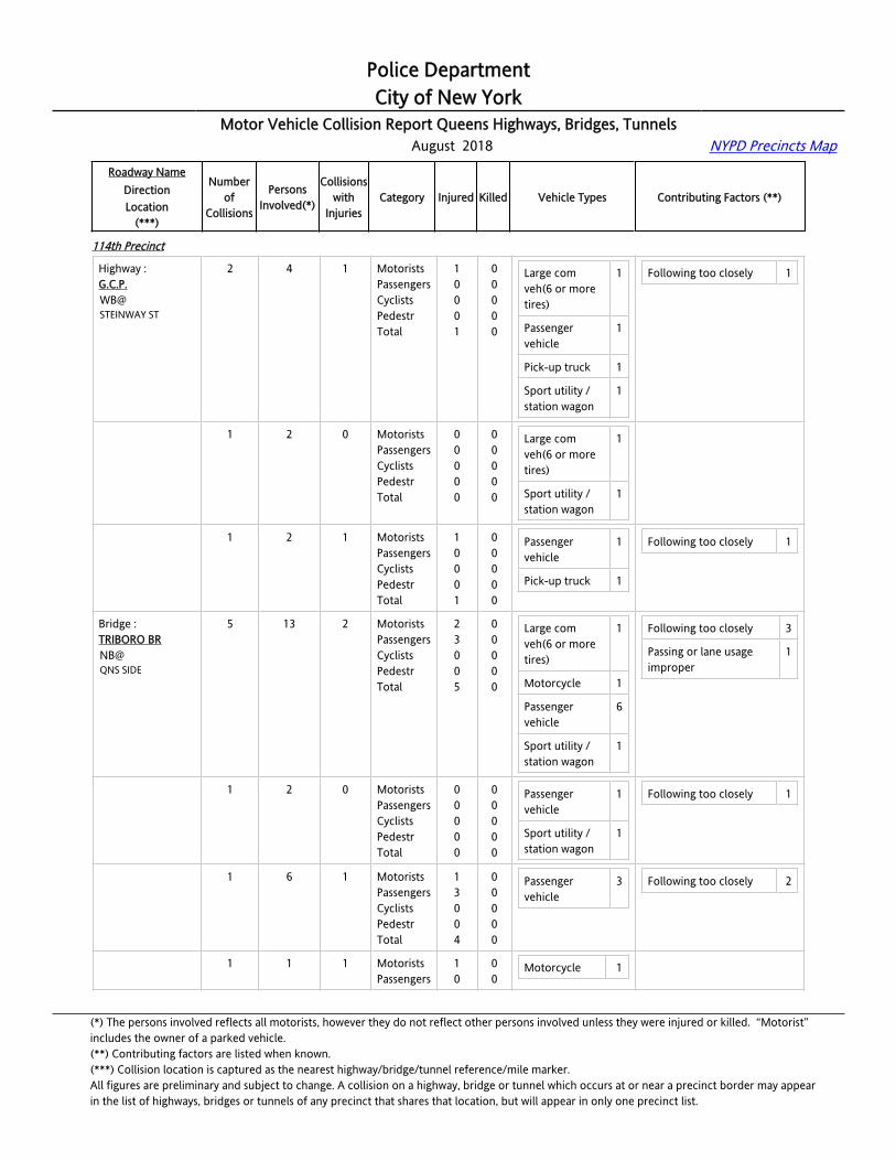
Police DepartmentCity of New York
Motor Vehicle Collision Report Queens Highways, Bridges, Tunnels August 2018 NYPD Precincts Map
Roadway NameDirectionLocation
(***)
Numberof
Collisions
PersonsInvolved(*)
Collisionswith
InjuriesCategory Injured Killed Vehicle Types Contributing Factors (**)
114th Precinct
Highway :G.C.P.WB@STEINWAY ST
2 4 1 MotoristsPassengersCyclistsPedestrTotal
10001
00000
Large com veh(6 or more tires)
1
Passenger vehicle
1
Pick-up truck 1
Sport utility / station wagon
1
Following too closely 1
Highway :G.C.P.WB@STEINWAY ST
1 2 0 MotoristsPassengersCyclistsPedestrTotal
00000
00000
Large com veh(6 or more tires)
1
Sport utility / station wagon
1
Highway :G.C.P.WB@STEINWAY ST
1 2 1 MotoristsPassengersCyclistsPedestrTotal
10001
00000
Passenger vehicle
1
Pick-up truck 1
Following too closely 1
Bridge : TRIBORO BRNB@QNS SIDE
5 13 2 MotoristsPassengersCyclistsPedestrTotal
23005
00000
Large com veh(6 or more tires)
1
Motorcycle 1
Passenger vehicle
6
Sport utility / station wagon
1
Following too closely 3
Passing or lane usage improper
1
Bridge : TRIBORO BRNB@QNS SIDE
1 2 0 MotoristsPassengersCyclistsPedestrTotal
00000
00000
Passenger vehicle
1
Sport utility / station wagon
1
Following too closely 1
Bridge : TRIBORO BRNB@QNS SIDE
1 6 1 MotoristsPassengersCyclistsPedestrTotal
13004
00000
Passenger vehicle
3 Following too closely 2
Bridge : TRIBORO BR
1 1 1 MotoristsPassengers
10
00
Motorcycle 1
(*) The persons involved reflects all motorists, however they do not reflect other persons involved unless they were injured or killed. “Motorist” includes the owner of a parked vehicle.(**) Contributing factors are listed when known.(***) Collision location is captured as the nearest highway/bridge/tunnel reference/mile marker.All figures are preliminary and subject to change. A collision on a highway, bridge or tunnel which occurs at or near a precinct border may appearin the list of highways, bridges or tunnels of any precinct that shares that location, but will appear in only one precinct list.
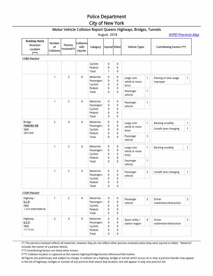
Police DepartmentCity of New York
Motor Vehicle Collision Report Queens Highways, Bridges, Tunnels August 2018 NYPD Precincts Map
Roadway NameDirectionLocation
(***)
Numberof
Collisions
PersonsInvolved(*)
Collisionswith
InjuriesCategory Injured Killed Vehicle Types Contributing Factors (**)
114th Precinct
NB@QNS SIDE
CyclistsPedestrTotal
001
000
Bridge : TRIBORO BRNB@QNS SIDE
1 2 0 MotoristsPassengersCyclistsPedestrTotal
00000
00000
Large com veh(6 or more tires)
1
Passenger vehicle
1
Passing or lane usage improper
1
Bridge : TRIBORO BRNB@QNS SIDE
1 2 0 MotoristsPassengersCyclistsPedestrTotal
00000
00000
Passenger vehicle
1
Bridge : TRIBORO BRSB@QNS SIDE
2 4 0 MotoristsPassengersCyclistsPedestrTotal
00000
00000
Large com veh(6 or more tires)
1
Passenger vehicle
3
Backing unsafely 1
Unsafe lane changing 1
Bridge : TRIBORO BRSB@QNS SIDE
1 2 0 MotoristsPassengersCyclistsPedestrTotal
00000
00000
Large com veh(6 or more tires)
1
Passenger vehicle
1
Backing unsafely 1
Bridge : TRIBORO BRSB@QNS SIDE
1 2 0 MotoristsPassengersCyclistsPedestrTotal
00000
00000
Passenger vehicle
2 Unsafe lane changing 1
115th Precinct
Highway :[email protected] E/O NORTHERN BL
1 2 0 MotoristsPassengersCyclistsPedestrTotal
00000
00000
Passenger vehicle
2 Driver inattention/distraction
2
Highway :G.C.P.EB@111 ST EX
2 4 0 MotoristsPassengersCyclistsPedestrTotal
00000
00000
Sport utility / station wagon
4 Driver inattention/distraction
3
(*) The persons involved reflects all motorists, however they do not reflect other persons involved unless they were injured or killed. “Motorist” includes the owner of a parked vehicle.(**) Contributing factors are listed when known.(***) Collision location is captured as the nearest highway/bridge/tunnel reference/mile marker.All figures are preliminary and subject to change. A collision on a highway, bridge or tunnel which occurs at or near a precinct border may appearin the list of highways, bridges or tunnels of any precinct that shares that location, but will appear in only one precinct list.

Police DepartmentCity of New York
Motor Vehicle Collision Report Queens Highways, Bridges, Tunnels August 2018 NYPD Precincts Map
Roadway NameDirectionLocation
(***)
Numberof
Collisions
PersonsInvolved(*)
Collisionswith
InjuriesCategory Injured Killed Vehicle Types Contributing Factors (**)
115th Precinct
Highway :G.C.P.EB@111 ST EX
1 2 0 MotoristsPassengersCyclistsPedestrTotal
00000
00000
Sport utility / station wagon
2 Driver inattention/distraction
1
Highway :G.C.P.EB@111 ST EX
1 2 0 MotoristsPassengersCyclistsPedestrTotal
00000
00000
Sport utility / station wagon
2 Driver inattention/distraction
2
Highway :G.C.P.EB@23 AV
2 4 0 MotoristsPassengersCyclistsPedestrTotal
00000
00000
Passenger vehicle
1
Small com veh(4 tires)
1
Sport utility / station wagon
2
Driver inattention/distraction
1
Failure to yield right-of-way
1
Highway :G.C.P.EB@23 AV
1 2 0 MotoristsPassengersCyclistsPedestrTotal
00000
00000
Passenger vehicle
1
Sport utility / station wagon
1
Failure to yield right-of-way
1
Highway :G.C.P.EB@23 AV
1 2 0 MotoristsPassengersCyclistsPedestrTotal
00000
00000
Small com veh(4 tires)
1
Sport utility / station wagon
1
Driver inattention/distraction
1
Highway :G.C.P.EB@24 AV
1 2 0 MotoristsPassengersCyclistsPedestrTotal
00000
00000
Passenger vehicle
1
Sport utility / station wagon
1
Unsafe lane changing 1
Highway :G.C.P.EB@84 ST
1 2 0 MotoristsPassengersCyclistsPedestrTotal
00000
00000
Passenger vehicle
1
Taxi vehicle 1
Unsafe lane changing 1
Highway :G.C.P.EB@88 ST
1 1 1 MotoristsPassengersCyclistsPedestrTotal
10001
00000
Passenger vehicle
1 Unsafe speed 1
(*) The persons involved reflects all motorists, however they do not reflect other persons involved unless they were injured or killed. “Motorist” includes the owner of a parked vehicle.(**) Contributing factors are listed when known.(***) Collision location is captured as the nearest highway/bridge/tunnel reference/mile marker.All figures are preliminary and subject to change. A collision on a highway, bridge or tunnel which occurs at or near a precinct border may appearin the list of highways, bridges or tunnels of any precinct that shares that location, but will appear in only one precinct list.

Police DepartmentCity of New York
Motor Vehicle Collision Report Queens Highways, Bridges, Tunnels August 2018 NYPD Precincts Map
Roadway NameDirectionLocation
(***)
Numberof
Collisions
PersonsInvolved(*)
Collisionswith
InjuriesCategory Injured Killed Vehicle Types Contributing Factors (**)
115th Precinct
Highway :G.C.P.EB@94 ST
2 5 0 MotoristsPassengersCyclistsPedestrTotal
00000
00000
Passenger vehicle
1
Sport utility / station wagon
4
Following too closely 3
Highway :G.C.P.EB@94 ST
1 2 0 MotoristsPassengersCyclistsPedestrTotal
00000
00000
Sport utility / station wagon
2 Following too closely 1
Highway :G.C.P.EB@94 ST
1 3 0 MotoristsPassengersCyclistsPedestrTotal
00000
00000
Passenger vehicle
1
Sport utility / station wagon
2
Following too closely 2
Highway :G.C.P.EB@95 ST
1 2 0 MotoristsPassengersCyclistsPedestrTotal
00000
00000
Sport utility / station wagon
2
Highway :G.C.P.WB@101 ST
1 3 0 MotoristsPassengersCyclistsPedestrTotal
00000
00000
Sport utility / station wagon
3 Driver inattention/distraction
3
Highway :G.C.P.WB@27 AV
2 4 0 MotoristsPassengersCyclistsPedestrTotal
00000
00000
Passenger vehicle
2
Sport utility / station wagon
2
Driver inattention/distraction
2
Unsafe lane changing 1
Highway :G.C.P.WB@27 AV
1 2 0 MotoristsPassengersCyclistsPedestrTotal
00000
00000
Passenger vehicle
2 Unsafe lane changing 1
Highway :G.C.P.WB@27 AV
1 2 0 MotoristsPassengersCyclistsPedestrTotal
00000
00000
Sport utility / station wagon
2 Driver inattention/distraction
2
Highway :G.C.P.
1 3 0 MotoristsPassengers
00
00
Passenger vehicle
1 Passing or lane usage improper
1
(*) The persons involved reflects all motorists, however they do not reflect other persons involved unless they were injured or killed. “Motorist” includes the owner of a parked vehicle.(**) Contributing factors are listed when known.(***) Collision location is captured as the nearest highway/bridge/tunnel reference/mile marker.All figures are preliminary and subject to change. A collision on a highway, bridge or tunnel which occurs at or near a precinct border may appearin the list of highways, bridges or tunnels of any precinct that shares that location, but will appear in only one precinct list.

Police DepartmentCity of New York
Motor Vehicle Collision Report Queens Highways, Bridges, Tunnels August 2018 NYPD Precincts Map
Roadway NameDirectionLocation
(***)
Numberof
Collisions
PersonsInvolved(*)
Collisionswith
InjuriesCategory Injured Killed Vehicle Types Contributing Factors (**)
115th Precinct
WB@29 AV
CyclistsPedestrTotal
000
000
Sport utility / station wagon
1
Highway :G.C.P.WB@31 AV
1 2 0 MotoristsPassengersCyclistsPedestrTotal
00000
00000
Passenger vehicle
2 Following too closely 1
Highway :G.C.P.WB@31 AV PED OVERPASS
1 4 1 MotoristsPassengersCyclistsPedestrTotal
02002
00000
Passenger vehicle
2 Driver inattention/distraction
1
Driver inexperience 1
Highway :G.C.P.WB@84 ST
1 2 0 MotoristsPassengersCyclistsPedestrTotal
00000
00000
Passenger vehicle
1
Taxi vehicle 1
Following too closely 1
Highway :G.C.P.WB@94 ST
2 4 0 MotoristsPassengersCyclistsPedestrTotal
00000
00000
Passenger vehicle
3
Sport utility / station wagon
1
Driver inattention/distraction
2
Highway :G.C.P.WB@94 ST
1 2 0 MotoristsPassengersCyclistsPedestrTotal
00000
00000
Passenger vehicle
1
Sport utility / station wagon
1
Driver inattention/distraction
1
Highway :G.C.P.WB@94 ST
1 2 0 MotoristsPassengersCyclistsPedestrTotal
00000
00000
Passenger vehicle
2 Driver inattention/distraction
1
Highway :G.C.P.WB@NORTHERN BL
1 2 0 MotoristsPassengersCyclistsPedestrTotal
00000
00000
Passenger vehicle
1
Highway :G.C.P.WB@WHITESTONE EXP EX
1 2 0 MotoristsPassengersCyclistsPedestr
0000
0000
Passenger vehicle
2 Passing or lane usage improper
1
(*) The persons involved reflects all motorists, however they do not reflect other persons involved unless they were injured or killed. “Motorist” includes the owner of a parked vehicle.(**) Contributing factors are listed when known.(***) Collision location is captured as the nearest highway/bridge/tunnel reference/mile marker.All figures are preliminary and subject to change. A collision on a highway, bridge or tunnel which occurs at or near a precinct border may appearin the list of highways, bridges or tunnels of any precinct that shares that location, but will appear in only one precinct list.

Police DepartmentCity of New York
Motor Vehicle Collision Report Queens Highways, Bridges, Tunnels August 2018 NYPD Precincts Map
Roadway NameDirectionLocation
(***)
Numberof
Collisions
PersonsInvolved(*)
Collisionswith
InjuriesCategory Injured Killed Vehicle Types Contributing Factors (**)
115th Precinct
Total 0 0
Highway :G.C.P./LAGUARDIA CDRWB@END AT 94 ST
1 2 0 MotoristsPassengersCyclistsPedestrTotal
00000
00000
Passenger vehicle
1
Sport utility / station wagon
1
Failure to yield right-of-way
1
(*) The persons involved reflects all motorists, however they do not reflect other persons involved unless they were injured or killed. “Motorist” includes the owner of a parked vehicle.(**) Contributing factors are listed when known.(***) Collision location is captured as the nearest highway/bridge/tunnel reference/mile marker.All figures are preliminary and subject to change. A collision on a highway, bridge or tunnel which occurs at or near a precinct border may appearin the list of highways, bridges or tunnels of any precinct that shares that location, but will appear in only one precinct list.


![Answers & Solutions · izR;sd iz'u ds fy, vad fuEufyf[kr ifjfLFkfr;ksa esa ls fdlh ,d ds vuqlkj fn; ... tc IysV v pky ls xfr'khy gS] rc eq[; cy ds lkis{k v.kqvksa dh lkisf{kd pky](https://static.fdocuments.in/doc/165x107/5c9cbcb288c99388348b87de/answers-solutions-izrsd-izu-ds-fy-vad-fueufyfkr-ifjflfkfrksa-esa-ls-fdlh.jpg)


