City of Lino Lakes · 2017-01-11 · Northeast Lino Lakes Drainage Improvement Project WSB Project...
33
City of Lino Lakes 600 Town Center Parkway, Lino Lakes, MN 55014 June 27, 2016 Northeast Lino Lakes Drainage Improvement Project City of Lino Lakes Anoka County, Minnesota WSB Project No. 2029-790
Transcript of City of Lino Lakes · 2017-01-11 · Northeast Lino Lakes Drainage Improvement Project WSB Project...
City of Lino Lakes 600 Town Center Parkway, Lino Lakes, MN 55014
June 27, 2016
Northeast Lino Lakes Drainage
Improvement Project
City of Lino Lakes Anoka County, Minnesota
WSB Project No. 2029-790
FEASIBILITY REPORT
Feasibility Report Northeast Lino Lakes Drainage Improvement Project WSB Project No. 2029-790
NORTHEAST LINO LAKES
DRAINAGE IMPROVEMENT PROJECT
FOR THE CITY OF LINO LAKES
June 27, 2016
Prepared By:
WSB & Associates, Inc. 701 Xenia Avenue South, Suite 300
Minneapolis, MN 55416 763-541-4800
763-541-1700 (Fax)
CERTIFICATION
Feasibility Report Northeast Lino Lakes Drainage Improvement Project WSB Project No. 2029-790
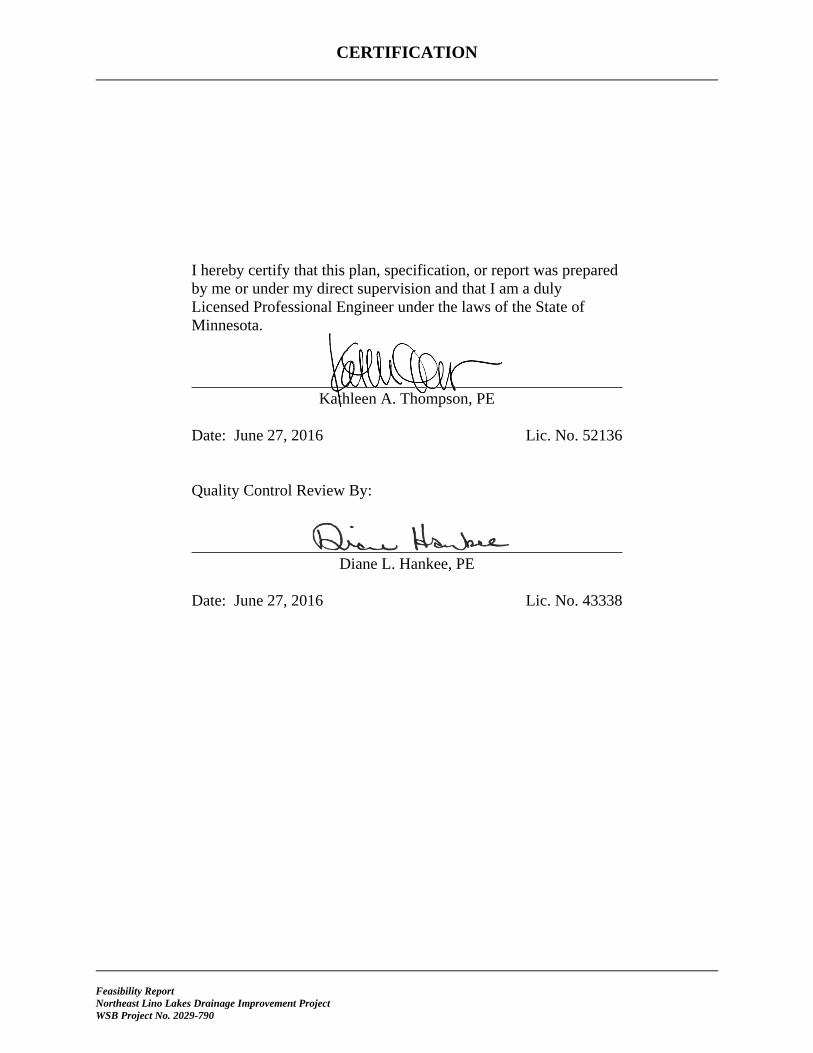
I hereby certify that this plan, specification, or report was prepared by me or under my direct supervision and that I am a duly Licensed Professional Engineer under the laws of the State of Minnesota.
Kathleen A. Thompson, PE Date: June 27, 2016 Lic. No. 52136 Quality Control Review By:
Diane L. Hankee, PE Date: June 27, 2016 Lic. No. 43338
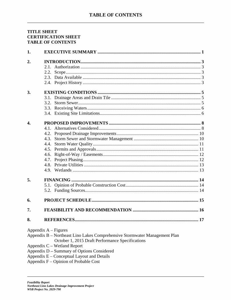
TABLE OF CONTENTS
Feasibility Report Northeast Lino Lakes Drainage Improvement Project WSB Project No. 2029-790
TITLE SHEET CERTIFICATION SHEET TABLE OF CONTENTS
1. EXECUTIVE SUMMARY ........................................................................................... 1
2. INTRODUCTION.......................................................................................................... 3 2.1. Authorization .......................................................................................................... 3 2.2. Scope ....................................................................................................................... 3 2.3. Data Available ........................................................................................................ 3 2.4. Project History ........................................................................................................ 3
3. EXISTING CONDITIONS ........................................................................................... 5 3.1. Drainage Areas and Drain Tile ............................................................................... 5 3.2. Storm Sewer ............................................................................................................ 5 3.3. Receiving Waters .................................................................................................... 6 3.4. Existing Site Limitations......................................................................................... 6
4. PROPOSED IMPROVEMENTS ................................................................................. 8 4.1. Alternatives Considered .......................................................................................... 8 4.2. Proposed Drainage Improvements ........................................................................ 10 4.3. Storm Sewer and Stormwater Management ......................................................... 10 4.4. Storm Water Quality ............................................................................................. 11 4.5. Permits and Approvals .......................................................................................... 11 4.6. Right-of-Way / Easements .................................................................................... 12 4.7. Project Phasing...................................................................................................... 12 4.8. Private Utilities ..................................................................................................... 13 4.9. Wetlands ............................................................................................................... 13
5. FINANCING ................................................................................................................ 14 5.1. Opinion of Probable Construction Cost ................................................................ 14 5.2. Funding Sources.................................................................................................... 14
6. PROJECT SCHEDULE .............................................................................................. 15
7. FEASIBILITY AND RECOMMENDATION .......................................................... 16
8. REFERENCES ............................................................................................................. 17 Appendix A – Figures Appendix B – Northeast Lino Lakes Comprehensive Stormwater Management Plan
October 1, 2015 Draft Performance Specifications Appendix C – Wetland Report Appendix D – Summary of Options Considered Appendix E – Conceptual Layout and Details Appendix F – Opinion of Probable Cost
Feasibility Report Northeast Lino Lakes Drainage Improvement Project WSB Project No. 2029-790 Page 1
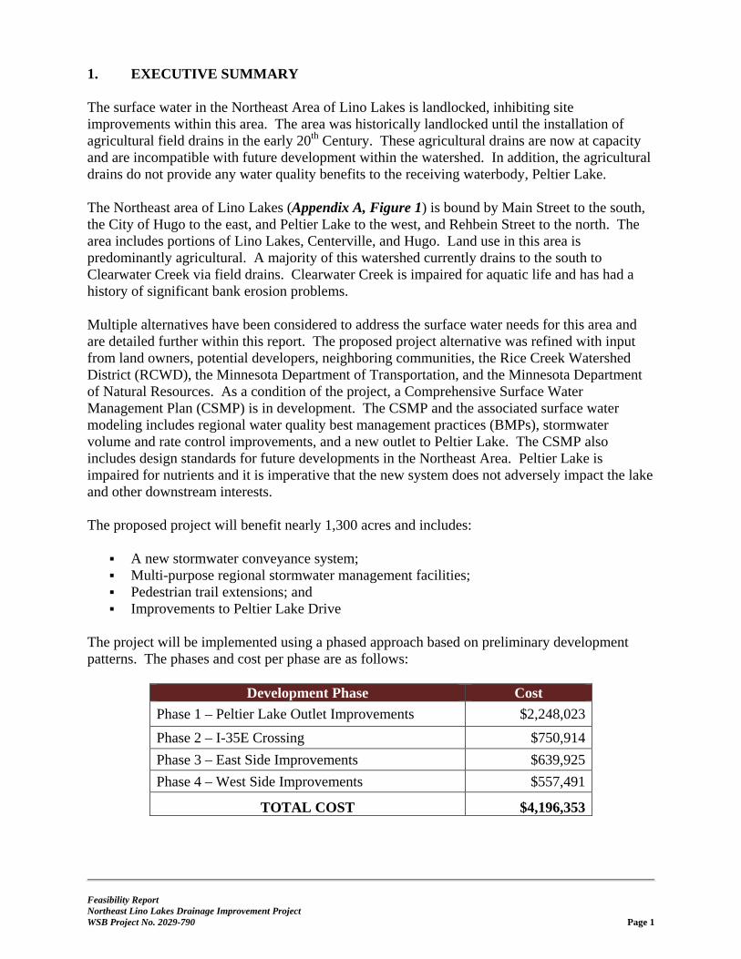
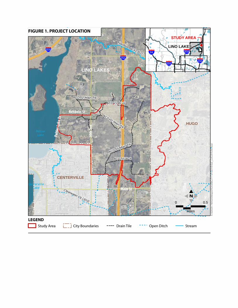
1. EXECUTIVE SUMMARY The surface water in the Northeast Area of Lino Lakes is landlocked, inhibiting site improvements within this area. The area was historically landlocked until the installation of agricultural field drains in the early 20th Century. These agricultural drains are now at capacity and are incompatible with future development within the watershed. In addition, the agricultural drains do not provide any water quality benefits to the receiving waterbody, Peltier Lake. The Northeast area of Lino Lakes (Appendix A, Figure 1) is bound by Main Street to the south, the City of Hugo to the east, and Peltier Lake to the west, and Rehbein Street to the north. The area includes portions of Lino Lakes, Centerville, and Hugo. Land use in this area is predominantly agricultural. A majority of this watershed currently drains to the south to Clearwater Creek via field drains. Clearwater Creek is impaired for aquatic life and has had a history of significant bank erosion problems. Multiple alternatives have been considered to address the surface water needs for this area and are detailed further within this report. The proposed project alternative was refined with input from land owners, potential developers, neighboring communities, the Rice Creek Watershed District (RCWD), the Minnesota Department of Transportation, and the Minnesota Department of Natural Resources. As a condition of the project, a Comprehensive Surface Water Management Plan (CSMP) is in development. The CSMP and the associated surface water modeling includes regional water quality best management practices (BMPs), stormwater volume and rate control improvements, and a new outlet to Peltier Lake. The CSMP also includes design standards for future developments in the Northeast Area. Peltier Lake is impaired for nutrients and it is imperative that the new system does not adversely impact the lake and other downstream interests. The proposed project will benefit nearly 1,300 acres and includes:
A new stormwater conveyance system; Multi-purpose regional stormwater management facilities; Pedestrian trail extensions; and Improvements to Peltier Lake Drive
The project will be implemented using a phased approach based on preliminary development patterns. The phases and cost per phase are as follows:
Development Phase Cost
Phase 1 – Peltier Lake Outlet Improvements $2,248,023
Phase 2 – I-35E Crossing $750,914
Phase 3 – East Side Improvements $639,925
Phase 4 – West Side Improvements $557,491
TOTAL COST $4,196,353

Feasibility Report Northeast Lino Lakes Drainage Improvement Project WSB Project No. 2029-790 Page 2
Funding for the project will be through surface water management fees and potential grants from Rice Creek Watershed District (RCWD), Minnesota Board Water and Soil Resources (BWSR), and the Public Facilities Authority (PFA). This project is feasible, necessary, and cost-effective from an engineering standpoint and should be constructed as proposed herein.
Feasibility Report Northeast Lino Lakes Drainage Improvement Project WSB Project No. 2029-790 Page 3
2. INTRODUCTION 2.1. Authorization On September 14, 2015, the City of Lino Lakes City Council authorized the preparation of an engineering feasibility report for the Northeast Lino Lakes Drainage System Improvements. 2.2. Scope The Northeast Lino Lakes Drainage Improvement Project consists of upsizing an existing culvert outlet to Peltier Lake and providing a new stormwater conveyance system to handle future runoff from the project area. The project includes a combination of traditional storm sewer and open channel conveyances, in addition to multi-purpose regional stormwater management facilities. These facilities will provide flood control and water quality treatment beyond the traditional permit requirements for development. This project would also alleviate some the capacity issues with the existing field drains to facilitate development in the project area. The project area can be seen in Appendix A, Figure 1 and encompasses the northeast section of Lino Lakes, north of Main Street and east of Peltier Lake, as well as portions of Centerville and Hugo that discharge water into the study area boundary. The objective is to develop a reginal storm water management plan to allow development of the property while protecting existing natural resources. This will be accomplished through storm water conveyance, water quality improvements, and runoff rate and volume control. 2.3. Data Available Information and materials used in the preparation of this report include the following:
Rice Creek Watershed District (RCWD) record drawings RCWD topographic maps and GIS data RCWD hydrologic and hydraulic modeling files City of Lino Lakes 2030 Comprehensive Plan [September 12, 2011] City of Lino Lakes Parks, Natural Open Space/Greenways, and Trail System Plan [2004] City of Lino Lakes Surface Water Management Plan [2005] City of Lino Lakes I-35E Corridor Alternative Urban Areawide Review (AUAR) [2005] City of Lino Lakes record drawings and GIS data City of Hugo 2030 Comprehensive Plan [2010] Anoka County LIDAR contour information Field observations of the area Additional references detailed in Section 8
2.4. Project History A Comprehensive Stormwater Management Plan (CSMP) is in development with input from the RCWD. This plan identifies the existing conditions and proposes a solution to provide surface water management within the study area.
Feasibility Report Northeast Lino Lakes Drainage Improvement Project WSB Project No. 2029-790 Page 4
The CMSP results in the establishment of performance standards to be followed for future developments in the northeast drainage area. The standards allow for phasing of development while limiting adverse impacts to neighboring properties and waterbodies. RCWD will use the CSMP performance standards to permit within the northeast drainage area. The following is a brief summary of the CSMP performance standards:
Development of regional storage facilities to limit discharges into Peltier Lake
Gated operation of the regional storage facilities to be operated by the City
Minimize the risk of flood impact (downstream or upstream) to downstream structures, infrastructure, and land currently within the floodplain
Volume control through water reuse within the drainage area
The entirety of the draft performance standards are in a RCWD letter dated October 1, 2015 Appendix B.
Feasibility Report Northeast Lino Lakes Drainage Improvement Project WSB Project No. 2029-790 Page 5
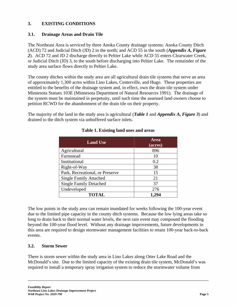
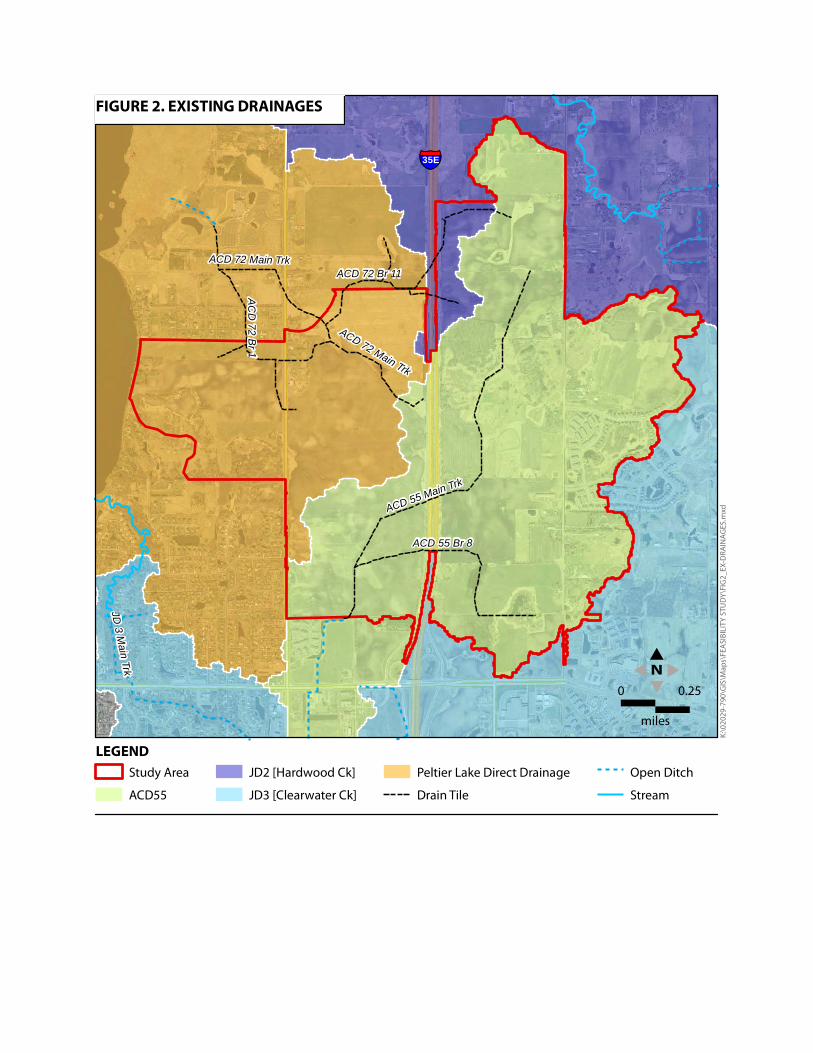
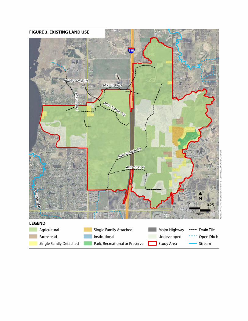
3. EXISTING CONDITIONS 3.1. Drainage Areas and Drain Tile The Northeast Area is serviced by three Anoka County drainage systems: Anoka County Ditch (ACD) 72 and Judicial Ditch (JD) 2 in the north; and ACD 55 in the south (Appendix A, Figure 2). ACD 72 and JD 2 discharge directly to Peltier Lake while ACD 55 enters Clearwater Creek, or Judicial Ditch (JD) 3, to the south before discharging into Peltier Lake. The remainder of the study area surface flows directly to Peltier Lake. The county ditches within the study area are all agricultural drain tile systems that serve an area of approximately 1,300 acres within Lino Lakes, Centerville, and Hugo. These properties are entitled to the benefits of the drainage system and, in effect, own the drain tile system under Minnesota Statues 103E (Minnesota Department of Natural Resources 1991). The drainage of the system must be maintained in perpetuity, until such time the assessed land owners choose to petition RCWD for the abandonment of the drain tile on their property. The majority of the land in the study area is agricultural (Table 1 and Appendix A, Figure 3) and drained to the ditch system via unbuffered surface inlets.
Table 1. Existing land uses and areas
Land Use Area
(acres) Agricultural 896 Farmstead 10 Institutional 0.2 Right-of-Way 38 Park, Recreational, or Preserve 15 Single Family Attached 21 Single Family Detached 37 Undeveloped 276
TOTAL 1,294
The low points in the study area can remain inundated for weeks following the 100-year event due to the limited pipe capacity in the county ditch systems. Because the low lying areas take so long to drain back to their normal water levels, the next rain event may compound the flooding beyond the 100-year flood level. Without any drainage improvements, future developments in this area are required to design stormwater management facilities to retain 100-year back-to-back events. 3.2. Storm Sewer There is storm sewer within the study area in Lino Lakes along Otter Lake Road and the McDonald’s site. Due to the limited capacity of the existing drain tile system, McDonald’s was required to install a temporary spray irrigation system to reduce the stormwater volume from
Feasibility Report Northeast Lino Lakes Drainage Improvement Project WSB Project No. 2029-790 Page 6
their site; however this is not a feasible long-term solution. The City of Hugo has stormwater infrastructure and storage which serves the development along the Lino Lakes and Hugo border. 3.3. Receiving Waters Peltier Lake has been listed as an impaired waterbody within the greater Anoka Chain of Lakes since 2002 for aquatic recreation, with the main pollutant identified as excess phosphorus from watershed runoff and internal loading (Minnesota Pollution Control Agency 2013). In addition, the Anoka Chain of Lakes has limited flood storage capacity (Houston Engineering, Inc. 2013). Any improvements to the drainage system will need to show no adverse impacts to receiving waters in terms of increased phosphorus loading or flooding potential. 3.4. Existing Site Limitations Anoka County Ditch (ACD) 55 and ACD 72 drain tiles were designed to provide drainage for agricultural lands and are already at capacity, limited by the crossings under I-35E. ACD 55 and ACD 72 both cross under I-35E, as shown in Appendix A, Figure 2, with a total capacity of 1.5 cubic feet per second (cfs) and 0.52 cfs, respectively (RCWD 2014). The City has also identified this area as being a Runoff Sensitive Area for stormwater rate and volume control given the limitations of the existing ditch systems (City of Lino Lakes 2005). The City of Hugo contributes 215 acres of the nearly 1,300 total acres and has an existing flow rate of 50.3 cfs into the City of Lino Lakes and the ACD 55 drain tile system. The City of Centerville contributes a minor amount of surface runoff to the study area, which contributes directly to Peltier Lake. The existing agricultural drainage system has been subject to repeated blow-outs and tile ruptures in recent years. In 2014, the Rice Creek Watershed District reviewed the ACD 55 and 72 systems and determined the failures were recurring due to:
Deterioration of the drain tile system, including sections of pipe that have pulled apart, as well as portions of the system have collapsed or are clogged with sediment; and
The drain tiles being undersized and unable to convey the incoming flows, resulting in a surcharged system.
During the summer of 2015, RCWD replaced several sections of ACD 55 main trunk and the ACD 72 main trunk, as well as several lateral branches. The drain tile system does not provide any water quality benefits to Peltier Lake and field inlets to the system do not have adequate buffers to prevent sediments from entering the system and Peltier Lake. Simple estimates indicate that the existing system discharges 588 pounds of phosphorus and 1,028 tons of total suspended solids to the lake on an annual basis. The constraints of the drain tile system have limited landowners’ ability to develop their land consistent with the City of Lino Lakes’ Comprehensive Plan. Development must meet RCWD Rule C for Stormwater Management Plans, which includes water quality and rate control. Because the existing drainage system is already at capacity, in some cases, new development
Feasibility Report Northeast Lino Lakes Drainage Improvement Project WSB Project No. 2029-790 Page 7
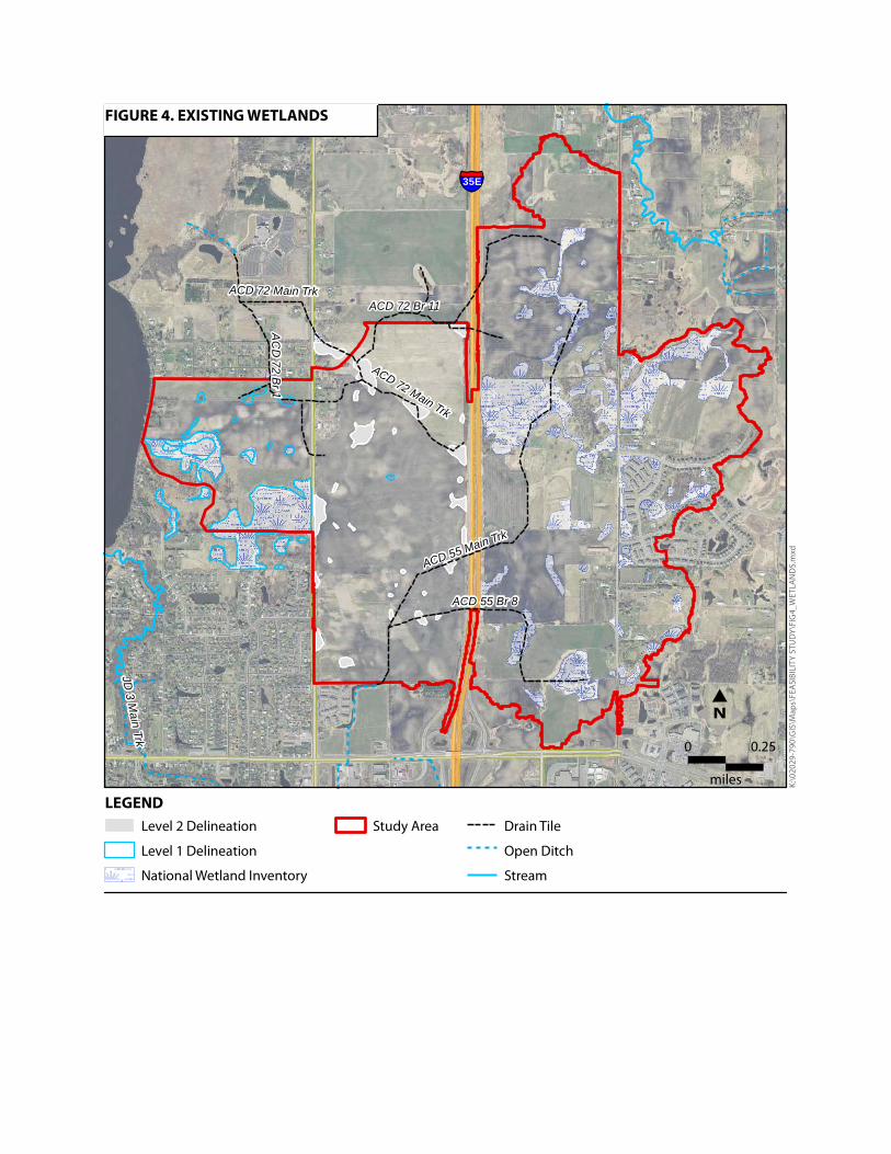
must limit stormwater discharge rates to no more than 1% of the existing runoff rates (Houston Engineering, Inc. 2013). In addition to limiting runoff rates, new developments must also treat their stormwater onsite to meet the water quality and volume reduction requirements of Rule C. Unfortunately the soils underlying the majority of the study area are poorly suited for infiltration and cannot meet the volume reduction requirement of Rule C. This has resulted in temporary infrastructure being built for stormwater irrigation because there was not an alternate way to meet the RCWD rules for surface water quality and storage. In addition to poor underlying soils, the study area also has a significant amount of wetlands (Appendix A, Figure 4), which limit stormwater management opportunities. A detailed wetland analysis is included in Appendix C.
Feasibility Report Northeast Lino Lakes Drainage Improvement Project WSB Project No. 2029-790 Page 8
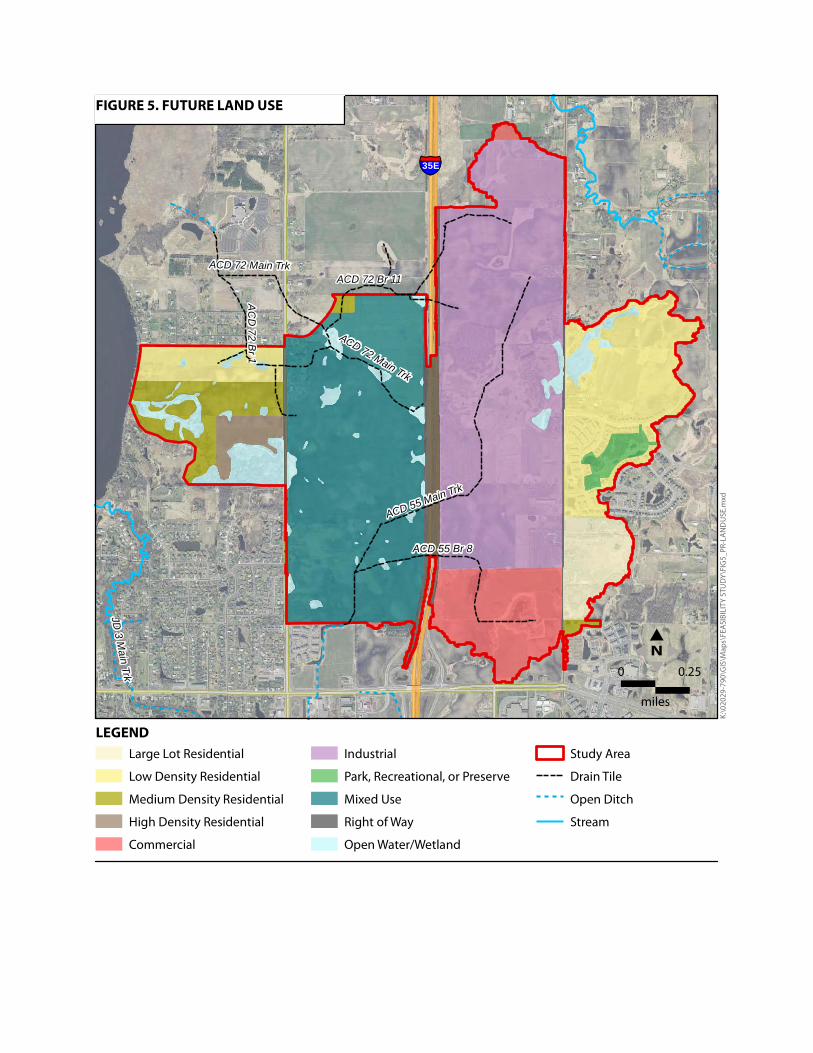
4. PROPOSED IMPROVEMENTS 4.1. Alternatives Considered In consideration of the City’s Comprehensive Plan where this area is guided for urban and mixed uses (Appendix A, Figure 5) it was determined that the existing drainage system would need to be addressed. Multiple alternatives were considered based on the future needs of the area (Table 2).
Table 2. Future Land Uses
Land Use Area
(acres) Commercial 98 High Density Residential 19 Industrial 412 Large Lot Residential 46 Low Density Residential 179 Medium Density Residential 61 Mixed Use 340 Open Water 72 Park, Recreational, or Preserve 16 Right-of-Way 51
TOTAL 1,294 As the existing county drain system is not sufficient to handle the increased runoff from a developed watershed. Options were considered to provide capacity for development, with the goal of limiting adverse impacts to downstream landowners and natural resources. The following options are discussed in greater detail in Appendix D. Option 1: Existing System to Remain The existing system is in need of maintenance. The RCWD completed a study in 2014 outlining system improvements. Even with the system improvements, the capacity of the existing system is not sufficient to develop the area consistent with the City of Lino Lakes’ Comprehensive Plan. For property owners to make improvements in this drainage area, per RCWD rules, they may need to dedicate 45% of their developable land for stormwater management including ponding of back-to-back 100-year flood events and infiltration requirements. This area has tight soils and alternatives to infiltration are costly and limited. Spray irrigation is temporarily being used to meet the RCWD requirements at the McDonald’s site until a regional BMP is constructed. The existing system does not provide any water quality treatment upstream of Peltier Lake which is classified as an impaired waterbody. Simple estimates indicate that the existing system discharges 588 pounds of phosphorus and 1,028 tons of total suspended solids to the lake on an annual basis. Any proposed project must not impair water quality or flood storage within or downstream of Peltier Lake.
Feasibility Report Northeast Lino Lakes Drainage Improvement Project WSB Project No. 2029-790 Page 9
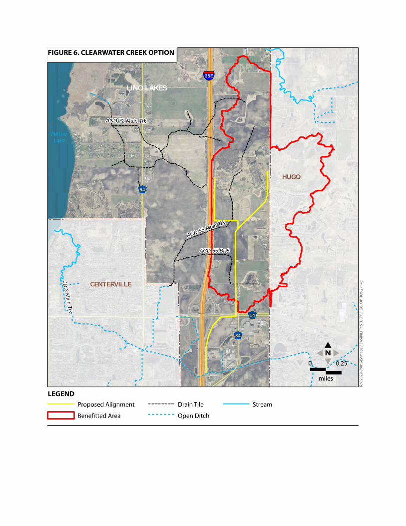
Option 2: Outlet to Clearwater Creek This option considers the lands drained by ACD 55 to the east of I-35E and proposes to reroute the drainage to the south to Clearwater Creek via storm pipe (Appendix A, Figure 6). This option benefits 710 acres, of which 495 acres are in Lino Lakes. This option is not recommended due to concerns that the increased discharge could cause bank erosion on Clearwater Creek. Option 3: New Outlet to Peltier Lake and Crossing Under I-35E There is a proposed mixed-use development between 20th Avenue and I-35E. The development would provide surface drainage via a series of connected ponds from I-35E to the 20th Avenue. The objective in recommending an alignment from 20th Avenue to Peltier Lake is to minimize impacts to undeveloped parcels and reduce associated easement acquisitions.
Alternative A – Open Channel Conveyance This option includes open-channel flow through a ditch system from 20th Avenue to Peltier Lake along the north property line (Appendix A, Figure 7). While feasible and consistent with the City of Lino Lakes’ I-35 Final Corridor Alternative Urban Areawide Review, it requires double the land acquisitions in a northern alignment resulting in the cost being 20 to 25 percent higher than Alternate B; and thus is not recommended. A southern alignment was considered, but dismissed when RCWD staff noted they would not permit the project with a southern alignment because of potential impacts to wetlands included in the City’s Comprehensive Wetland Protection and Management Plan (CWPMP).
Alternative B - Storm Sewer Pipe Outlet This option provides a new outlet to Peltier Lake via a 72-inch storm drain that runs from I-35E to Peltier Lake. This system is capable of capturing the ACD 55 and ACD 72 drainage systems upstream of I-35E, in addition to collecting runoff from the remaining study area (Appendix A, Figure 8). The area above the pipe could be used for public greenspace, as well as storm water ponding as this area develops in the future. In the interim, the landowners could continue to farm on the easement. Because of the size of the proposed pipeline, it would be a permanent feature on the landscape and a potential encumbrance that future developers would need to design around.
Option 4 – Peltier Lake Outlet Improvements This option takes advantage of an existing culvert crossing under Peltier Lake Drive and uses an existing drainage way to convey stormwater flows from the study area to Peltier Lake (Appendix A, Figure 9). This option is intended to give affected landowners the most flexibility for future development. The existing drainage way would be permanently restored to a two-stage ditch design, while the eastern portion would be a temporary ditch that could be incorporated as part of future development plans. The intent is that ultimately the alignment would be an aesthetic feature for future developments, with a meandering low flow channel and floodplain bench that can be planted to provide biofiltration and additional water quality benefits for Peltier Lake.
Recommended Option Option 4 is recommended as it provides the needed surface water conveyance and stormwater runoff rate and flood control, while also providing an amenity to the community. Because it is
Feasibility Report Northeast Lino Lakes Drainage Improvement Project WSB Project No. 2029-790 Page 10
primarily an open channel, the system will not be constrained by a pipe size as is the case under current conditions, and will be more adaptable to climate change and future development requirements. The channel can drain the regional storage systems effectively and efficiently, thereby minimizing the bounce in ponds from successive storm events. It also provides a known normal water elevation in the low areas, around which the designers may build future development to be safe from flooding. Option 4 also includes a new crossing under I-35E near the existing ACD 55 crossing (Appendix A, Figure 9). Final design and coordination with RCWD and MnDOT will determine if this crossing is a single crossing or two smaller crossings under I-35E. 4.2. Proposed Drainage Improvements The Peltier Lake outlet improvement and crossing under I-35E via a storm sewer pipe system is recommended as the most cost-effective alternative. The proposed project (Appendix A, Figure 9) includes:
Replacing the existing culvert under Peltier Lake Drive New open channel ditch conveyance from Peltier Lake Drive to 20th Avenue New 60-inch storm drain crossing under I-35E to proposed regional storage facility New regional storage facilities, phased with future developments, to provide flood
control storage and additional water quality treatment opportunities A public greenway corridor with additional water quality features, such as iron-
enhanced filtration or biofiltration Outlet control structures with gates on selected regional storage facilities to minimize
the risk of adversely impacting flood levels on Peltier Lake Preserve the agricultural drain tile system to maintain upstream drainage rights until
all land within the study area develops. Drain tile may be abandoned or realigned as development progresses, at the benefitted landowners’ expense and discretion.
The conceptual layout and system details are provided in Appendix E. Additional design requirements proposed for land development within the study area are summarized in Appendix B. 4.3. Storm Sewer and Stormwater Management The City’s proposed storm sewer system and drainage design requirements will be in conformance with the City’s performance standards, and as permitted by RCWD. Construction of a stormwater collection and conveyance system will be necessary to direct stormwater to the new crossing and constructed channel. This system will reduce flooding
Feasibility Report Northeast Lino Lakes Drainage Improvement Project WSB Project No. 2029-790 Page 11
within the study area and improve drainage conditions throughout the Northeast Lino Lakes Area. There are multiple ponding locations proposed with the Northeast Lino Lakes Comprehensive Stormwater Management Plan. At this time, it is proposed to utilize existing wetland complexes for flood storage by providing an outlet control structure with operable gate at the normal water level. In the event of a 100-year design storm, the gates can be closed to minimize the risk of increasing the flood stage on Peltier Lake, and the wetlands would store the water until the gates are opened after the flood threat on Peltier Lake has passed. The exact location and design of these regional storage facilities will be determined as the design progresses. It will be expected that the storage areas will experience a significant bounce in elevation during 100-year storm event and will need to be planted with a suitable planting palette that can tolerate periodic inundation to maintain vegetation. 4.4. Storm Water Quality The study area will include a variety of measures to provide treatment and improve water quality in Peltier Lake and the Anoka Chain of Lakes to minimize impacts related to this project. All individual developments will be required to manage stormwater on site to the current and applicable RCWD rules. It is anticipated the study area will include a water quality treatment train with sedimentation BMPs located in upland areas designed to remove solids and particulate matter. This will be combined with surface and media filtration to remove dissolved particulates, nitrogen, and phosphorus prior to entering the new storm sewer. The existing and proposed total phosphorus loading from the study area to Peltier Lake were evaluated at a conceptual level, using event mean concentrations from the Minnesota Stormwater Manual for the general land use types within the study area. Without any water quality treatment, the development of the study area would result in nearly doubling the total phosphorus loading to Peltier Lake annually. The City of Lino Lakes stormwater management ordinance and the RCWD rules will require water quality treatment practices be implemented for all new developments. The required BMPs are estimated to remove roughly 600 pounds of total phosphorus annually, which would result in a total load reduction of 130 pounds from existing conditions. Refer to Appendices B and E for proposed design requirements and conceptual details for the study area. 4.5. Permits and Approvals Construction of the new crossing, channel and outlet improvements will disturb more than one acre of land and will require a National Pollution Discharge Elimination Systems (NPDES) General Stormwater Permit [MNR 100001] that must be obtained by Lino Lakes from the Minnesota Pollution Control Agency (MPCA).
Feasibility Report Northeast Lino Lakes Drainage Improvement Project WSB Project No. 2029-790 Page 12
The project includes improving an existing outlet to Peltier Lake, as such the City will need to obtain a DNR Public Waters Work permit (GP2004-0001) from the MnDNR, as well as to obtain a RCWD permit to demonstrate no adverse impacts will be created as result of this project. The project also includes a culvert crossing under I-35E; as such the City will need to obtain a Utility Accommodation on Trunk Highway Right of Way Permit (Form 2525) and a Miscellaneous Work on a Trunk Highway Right of Way permit (Form 1723) from MnDOT. The project includes a storm drain crossing under 20th Avenue (CSAH 54) and a Right of Way Permit from Anoka County may be required. The alignment has been chosen to avoid or minimize wetland impacts where possible; however any modifications to existing wetlands would require approval by the Technical Evaluation Panel (TEP). Given the complexity of the project it is anticipated that the City and staff will need to meet with the above agencies individually in order to facilitate permit approvals. 4.6. Right-of-Way / Easements Right-of-way needs will be evaluated during final design. It is anticipated that some temporary construction easements will be required. Easement acquisition for the Koch pipeline on the east side is anticipated, as well as a power line easement on the west side. Easements related to the regional storage basins will be acquired as part of the platting process for individual developments. 4.7. Project Phasing The project will be constructed in several phases (Appendix A, Figure 10), as funding and land development allows. The project will be constructed from downstream to upstream, starting with the improved Peltier Lake outfall and channel to 20th Avenue, finishing with upstream regional storage facilities. Phase 1 will include replacement of the existing culvert outlet at Peltier Lake Drive and the reconstruction of the drainage way from Peltier Lake Drive to 20th Avenue. Once the outlet channel is reconstructed, the neighboring properties on the west side could develop and discharge treated stormwater to the channel. Development of the regional stormwater facility between Peltier Lake Drive and 20th Avenue would need to be constructed concurrently with any development. The new channel will also provide an outlet for the proposed ponding facilities being constructed between 20th Avenue and I-35E, also part of Phase 1. Phase 2 will include the installation of a new 60-inch crossing under I-35E and an extension of the storm sewer beyond the MnDOT right-of-way to allow for future extension of the sewer along Otter Lake Trail.
Feasibility Report Northeast Lino Lakes Drainage Improvement Project WSB Project No. 2029-790 Page 13
Phase 3 would be constructed concurrently with the Otter Lake Trail extension and includes expanding the storm sewer system east of I-35E to the Otter Lake Trail extension and within the proposed right-of-way. Future phases include construction of additional regional storage facilities, water quality features, recreational enhancements, and additional storm sewer infrastructure as needed for development. The timing of these features will depend on individual landowners and development interests. At all times during project construction and phasing, upstream drainage will be maintained by realigning the county ditches, at the developers expense, or leaving them in place for future abandonment when the study area is fully built out. 4.8. Private Utilities The Koch Pipeline Company has three crude oil pipelines that run through the study area, roughly from 20th Avenue and 80th Street in the northwest to Main Street at the Hugo border. The proposed 60-inch crossing under I-35E avoids the Koch pipeline, but final design of the storm sewer infrastructure east of I-35E will need to ensure there are no conflicts with the pipelines. It is anticipated that coordination with the Koch Pipeline Company will be required in order to construct the project as proposed. There is also an overhead electric line that runs north-south through the western portion of the study area. It is anticipated that coordination with the utility company will be required to construct the temporary ditch. 4.9. Wetlands All practical measures will be taken to prevent any inadvertent temporary drainage of wetlands from the construction and placement of the new pipeline and outfall to Peltier Lake. These practices include following setback requirements (Minnesota Board of Water & Soil Resources 2013), using bentonite plugs and/or steel casing for the areas where storm sewer or culvert runs through wetlands, and prohibiting the use of gravel bedding in these areas.
Feasibility Report Northeast Lino Lakes Drainage Improvement Project WSB Project No. 2029-790 Page 14
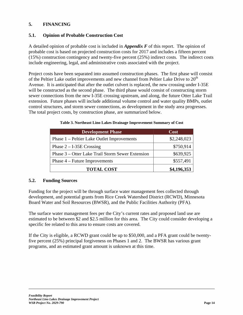
5. FINANCING 5.1. Opinion of Probable Construction Cost A detailed opinion of probable cost is included in Appendix F of this report. The opinion of probable cost is based on projected construction costs for 2017 and includes a fifteen percent (15%) construction contingency and twenty-five percent (25%) indirect costs. The indirect costs include engineering, legal, and administrative costs associated with the project. Project costs have been separated into assumed construction phases. The first phase will consist of the Peltier Lake outlet improvements and new channel from Peltier Lake Drive to 20th Avenue. It is anticipated that after the outlet culvert is replaced, the new crossing under I-35E will be constructed as the second phase. The third phase would consist of constructing storm sewer connections from the new I-35E crossing upstream, and along, the future Otter Lake Trail extension. Future phases will include additional volume control and water quality BMPs, outlet control structures, and storm sewer connections, as development in the study area progresses. The total project costs, by construction phase, are summarized below.
Table 3. Northeast Lino Lakes Drainage Improvement Summary of Cost
Development Phase Cost
Phase 1 – Peltier Lake Outlet Improvements $2,248,023
Phase 2 – I-35E Crossing $750,914
Phase 3 – Otter Lake Trail Storm Sewer Extension $639,925
Phase 4 – Future Improvements $557,491
TOTAL COST $4,196,353 5.2. Funding Sources Funding for the project will be through surface water management fees collected through development, and potential grants from Rice Creek Watershed District (RCWD), Minnesota Board Water and Soil Resources (BWSR), and the Public Facilities Authority (PFA). The surface water management fees per the City’s current rates and proposed land use are estimated to be between $2 and $2.5 million for this area. The City could consider developing a specific fee related to this area to ensure costs are covered. If the City is eligible, a RCWD grant could be up to $50,000, and a PFA grant could be twenty-five percent (25%) principal forgiveness on Phases 1 and 2. The BWSR has various grant programs, and an estimated grant amount is unknown at this time.
Feasibility Report Northeast Lino Lakes Drainage Improvement Project WSB Project No. 2029-790 Page 15
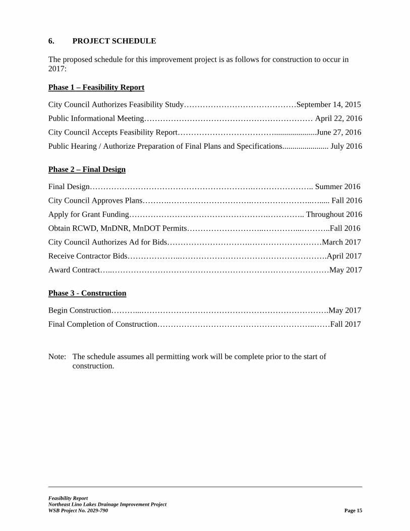
6. PROJECT SCHEDULE The proposed schedule for this improvement project is as follows for construction to occur in 2017: Phase 1 – Feasibility Report
City Council Authorizes Feasibility Study……………………………………September 14, 2015
Public Informational Meeting……………………………………………………… April 22, 2016
City Council Accepts Feasibility Report……………………………….....................June 27, 2016
Public Hearing / Authorize Preparation of Final Plans and Specifications....................... July 2016
Phase 2 – Final Design
Final Design…………………………………………………….………………….. Summer 2016
City Council Approves Plans……….………………………….…………………..…..... Fall 2016
Apply for Grant Funding…………………………………………….………….. Throughout 2016
Obtain RCWD, MnDNR, MnDOT Permits………………………..…………...………..Fall 2016
City Council Authorizes Ad for Bids………………………….………………………March 2017
Receive Contractor Bids………………..……………………………………………….April 2017
Award Contract…..………………………………………………………………………May 2017
Phase 3 - Construction
Begin Construction………...…………………………………………………………….May 2017
Final Completion of Construction…………………………………………………..……Fall 2017
Note: The schedule assumes all permitting work will be complete prior to the start of
construction.
Feasibility Report Northeast Lino Lakes Drainage Improvement Project WSB Project No. 2029-790 Page 16
7. FEASIBILITY AND RECOMMENDATION The Northeast Lino Lakes Drainage System Improvement Project includes a reconstructed stormwater outlet at Peltier Lake, drainage improvements, water quality and volume control BMPs, and appurtenant work. The total cost of the project is estimated at $4,196,353 to be implemented in phases as development occurs. Based on our analysis and data presented, the proposed project is feasible, necessary, and cost effective from an engineering standpoint. We recommend construction of the proposed improvements as detailed in this report and as determined financially feasible by the City Council.
Feasibility Report Northeast Lino Lakes Drainage Improvement Project WSB Project No. 2029-790 Page 17
8. REFERENCES City of Hugo. "2030 Comprehensive Plan." City of Hugo. March 15, 2010.
http://www.ci.hugo.mn.us/index.asp?SEC=4A42E80D-D1B1-48A1-940D-F92071D6D492&Type=B_LIST (accessed October 20, 2015).
City of Lino Lakes. "2030 Comprehensive Plan." City of Lino Lakes. September 12, 2011. http://www.ci.lino-lakes.mn.us/index.asp?SEC=67FBFAB1-0B78-448F-85B7-AFF5C3B73FEF&Type=B_BASIC (accessed October 20, 2015).
—. "I-35E Corridor Final Alternative Urban Areawide Review (AUAR)." City of Lino Lakes. September 26, 2005. http://www.ci.lino-lakes.mn.us/index.asp?SEC=581A5670-E592-4178-B9B2-7B0B72922A8E&Type=B_BASIC (accessed October 20, 2015).
—. "Parks, Natural Open Space/Greenways, and Trail System Plan." Park System Plan. August 2004. http://www.ci.lino-lakes.mn.us/index.asp?SEC=8F6D51B8-D88A-40BA-98DA-B5805AE7C568&DE=A2373B63-7508-48A1-A507-F42A0255D30B&Type=B_BASIC (accessed October 20, 2015).
—. "Surface Water Management Plan." City of Lino Lakes. December 2005. http://www.ci.lino-lakes.mn.us/vertical/Sites/%7B92EFCBF5-B800-4B28-AD6A-B8C3B7009FB0%7D/uploads/SWMP-Final_with_Appendix.pdf (accessed October 20, 2015).
Houston Engineering, Inc. Hydraulics and Hydrology Evaluation Anoka County Ditch 55 Memo. May 6, 2013.
Minnesota Board of Water & Soil Resources. "BWSR Guidance Concerning NRCS-Developed Drainage Setback Tables." October 2013. http://www.bwsr.state.mn.us/wetlands/delineation/Drainage_setback_guidance.pdf (accessed June 21, 2016).
Minnesota Department of Natural Resources. "Minnesota Public Drainage Manual." Minnesota Department of Natural Resources. September 1991. http://files.dnr.state.mn.us/publications/waters/Minnesota_Public_Drainage_Manual.pdf (accessed October 20, 2015).
Minnesota Pollution Control Agency. "Peltier Lake and Centerville Lake TMDL." Minnesota Pollution Control Agency. July 2013. http://www.pca.state.mn.us/index.php/view-document.html?gid=20171 (accessed October 20, 2015).
RCWD and Minnesota Pollution Control Agency. "Lino Lakes Chain of Lakes Nutrient TMDL." Minnesota Pollution Control Agency. July 2013. http://www.pca.state.mn.us/index.php/view-document.html?gid=17164 (accessed October 20, 2015).
RCWD. "Anoka County Ditch 55 Repair Memorandum." Rice Creek Watershed District. June 16, 2014. http://www.ricecreek.org/vertical/Sites/%7BF68A5205-A996-4208-96B5-2C7263C03AA9%7D/uploads/ACD_55_Repair_memo_FINAL_6-16-2014.pdf (accessed October 20, 2015).
—. "Anoka County Ditch 72 Repair Memorandum." Rice Creek Watershed District. October 16, 2014. http://rcwd.houstoneng.net/ditchportal/Historic%20Documents/Scans/ACD%2072/Memos%20and%20Transmittals/RCWD_ACD72_MT_10162014_11.pdf (accessed October 20, 2015).
—. "Rice Creek Watershed District Rules." Rice Creek Watershed District. December 1, 2014. http://www.ricecreek.org/vertical/Sites/%7BF68A5205-A996-4208-96B5-
Feasibility Report Northeast Lino Lakes Drainage Improvement Project WSB Project No. 2029-790 Page 18
2C7263C03AA9%7D/uploads/Final_adopted_RCWD_rule_11-12-2014.pdf (accessed October 20, 2015).
Feasibility Report Northeast Lino Lakes Drainage Improvement Project WSB Project No. 2029-790
APPENDIX A
Figures
§̈¦35E
ACD 55 Br 8
ACD 55 Main Trk
ACD 72 Main Trk
ACD 72 Br 11
CENTERVILLE
HUGO
LINO LAKES
ACD 72 Main Trk
§̈¦35W
Hardwood Ck [JD2]
Clearwater Ck [JD3]
20th
Ave
Main St
Pelti
er La
ke D
r
Rehbein St
PeltierLake
CentervilleLake
LEGENDStudy Area City Boundaries Drain Tile Open Ditch Stream
N
FIGURE 1. PROJECT LOCATION
K:\
020
29
-790
\GIS
\Ma
ps\
FE
AS
IBIL
ITY
ST
UD
Y\F
IG0
_LO
CA
TIO
N.m
xd
LINO LAKES
4STUDY AREA
§̈¦35E
§̈¦35W
§̈¦694
§̈¦94
0 0.5
Miles
§̈¦35E
ACD 55 Br 8
ACD 55 Main Trk
ACD 72 Main TrkACD 72 Br 11
AC
D 7
2 B
r 1
JD 3 M
ain Trk
ACD 72 Main Trk
0 0.25
miles
LEGENDStudy Area
ACD55
JD2 [Hardwood Ck]
JD3 [Clearwater Ck]
Peltier Lake Direct Drainage
Drain Tile
Open Ditch
Stream
N
FIGURE 2. EXISTING DRAINAGES
K:\0
2029
-790
\GIS
\Map
s\FE
ASI
BILI
TY S
TUD
Y\FI
G2_
EX-D
RAIN
AGES
.mxd
§̈¦35E
ACD 55 Br 8
ACD 55 Main Trk
ACD 72 Main TrkACD 72 Br 11
AC
D 7
2 B
r 1
JD 3 M
ain Trk
ACD 72 Main Trk
0 0.25
miles
LEGENDAgricultural
Farmstead
Single Family Detached
Single Family Attached
Institutional
Park, Recreational or Preserve
Major Highway
Undeveloped
Study Area
Drain Tile
Open Ditch
Stream
N
FIGURE 3. EXISTING LAND USE
K:\0
2029
-790
\GIS
\Map
s\FE
ASI
BILI
TY S
TUD
Y\FI
G3_
EX-L
AN
DU
SE.m
xd
§̈¦35E
ACD 55 Br 8
ACD 55 Main Trk
ACD 72 Main TrkACD 72 Br 11
AC
D 7
2 B
r 1
JD 3 M
ain Trk
ACD 72 Main Trk
0 0.25
miles
LEGENDLevel 2 Delineation
Level 1 Delineation
National Wetland Inventory
Study Area Drain Tile
Open Ditch
Stream
N
FIGURE 4. EXISTING WETLANDS
K:\0
2029
-790
\GIS
\Map
s\FE
ASI
BILI
TY S
TUD
Y\FI
G4_
WET
LAN
DS.
mxd
§̈¦35E
ACD 55 Br 8
ACD 55 Main Trk
ACD 72 Main TrkACD 72 Br 11
AC
D 7
2 B
r 1
JD 3 M
ain Trk
ACD 72 Main Trk
0 0.25
miles
LEGENDLarge Lot Residential
Low Density Residential
Medium Density Residential
High Density Residential
Commercial
Industrial
Park, Recreational, or Preserve
Mixed Use
Right of Way
Open Water/Wetland
Study Area
Drain Tile
Open Ditch
Stream
N
FIGURE 5. FUTURE LAND USE
K:\0
2029
-790
\GIS
\Map
s\FE
ASI
BILI
TY S
TUD
Y\FI
G5_
PR-L
AN
DU
SE.m
xd
§̈¦35E
ACD 55 Br 8
ACD 55 Main Trk
ACD 72 Main Trk
CENTERVILLE
HUGO
LINO LAKES
JD 3 M
ain Trk
PeltierLake
MN54
MN84
MN14
0 0.25
miles
LEGENDProposed Alignment
Benefitted Area
Drain Tile
Open Ditch
Stream
N
FIGURE 6. CLEARWATER CREEK OPTION
K:\0
2029
-790
\GIS
\Map
s\FE
ASI
BILI
TY S
TUD
Y\FI
G6_
OPT
ION
2.m
xd
§̈¦35E
ACD 55 Br 8
ACD 55 Main Trk
ACD 72 Main Trk
CENTERVILLE
HUGO
LINO LAKES
JD 3 M
ain Trk
PeltierLake
MN54
MN14MN84
0 0.25
miles
LEGENDProposed Alignment
Benefitted Area
Conceptual Regional Storage
Drain Tile
Open Ditch
Stream
N
FIGURE 7. NEW OUTLET OPTION 3A
K:\0
2029
-790
\GIS
\Map
s\FE
ASI
BILI
TY S
TUD
Y\FI
G7_
OPT
ION
3A.m
xd

§̈¦35E
ACD 55 Br 8
ACD 55 Main Trk
ACD 72 Main Trk
CENTERVILLE
HUGO
LINO LAKES
JD 3 M
ain Trk
PeltierLake
MN54
MN14MN84
0 0.25
miles
LEGENDProposed Alignment
Benefitted Area
Conceptual Regional Storage
Drain Tile
Open Ditch
Stream
N
FIGURE 8. NEW OUTLET OPTION 3B
K:\0
2029
-790
\GIS
\Map
s\FE
ASI
BILI
TY S
TUD
Y\FI
G8_
OPT
ION
3B.m
xd
§̈¦35E
ACD 55 Br 8
ACD 55 Main Trk
ACD 72 Main Trk
CENTERVILLE
HUGO
LINO LAKES
JD 3 M
ain Trk
PeltierLake
MN54
MN14MN84
0 0.25
miles
LEGENDProposed Alignment
Benefitted Area
Conceptual Regional Storage
Drain Tile
Open Ditch
Stream
N
FIGURE 9. OPTION 4: EXISTING OUTLET
K:\0
2029
-790
\GIS
\Map
s\FE
ASI
BILI
TY S
TUD
Y\FI
G9_
OPT
ION
3C.m
xd

§̈¦35E
ACD 72 Main Trk
CENTERVILLE
HUGO
LINO LAKES
JD 3 M
ain Trk
AC
D 5
5 M
ain
Trk
PeltierLake
MN54
MN14MN84
0 0.25
miles
LEGEND1st Phase [Peltier Lake Outlet and Regional BMPs]
2nd Phase [I-35E Replacement Culvert]
3rd Phase [Otter Lake Trail Extension Storm Sewer]
Future Phases [Timing depends on development]
Study Area
Drain Tile
Open Ditch
Stream
N
FIGURE 10. CONSTRUCTION PHASING
K:\0
2029
-790
\GIS
\Map
s\FE
ASI
BILI
TY S
TUD
Y\FI
G10
_PR-
PHA
SIN
G.m
xd