City of Kenmore Pedestrian and Bicycle Safety Strategy … and... · City of Kenmore Pedestrian and...
53
City of Kenmore Pedestrian and Bicycle Safety Strategy and Recommendations August, 2014
Transcript of City of Kenmore Pedestrian and Bicycle Safety Strategy … and... · City of Kenmore Pedestrian and...

City of Kenmore
Pedestrian and
Bicycle Safety
Strategy and
Recommendations
August, 2014

City of Kenmore Pedestrian and Bicycle Safety Strategy and Recommendations Page 2
Acknowledgements
Ad Hoc Committee on Pedestrian and Bicycle Safety Members
Mark Abersold Victoria Chaussee
Robert Greene Andrea Laltoo
Doug Levy David Maehren
Katrina Rose
City of Kenmore Committee Staff
Kris Overleese, Engineering and Environmental Services Director
Andrew Calkins, Graduate Intern
The Pedestrian and Bicycle Safety Strategy and Recommendations were crafted by the seven members of the Ad Hoc Committee from May through August, 2014. The Strategy and Recommendations document was prepared by city staff to reflect their final set of
recommendations.
Some of the images used inside this document were taken by Heston Photography, King County Parks, and the City of Kenmore.

City of Kenmore Pedestrian and Bicycle Safety Strategy and Recommendations Page 3
Table of Contents
EXECUTIVE SUMMARY
4
INTRODUCTION
6
Purpose of the Strategy and Recommendations 6
Project Background 6
EXISTING CONDITIONS AND BARRIERS
8
The Problem 8
There is a Need for a More Walkable and Bikeable City 8
How Has Kenmore Improved Pedestrian and Bicycle Safety Since Incorporation? 9
Barriers to Pedestrian and Bicycle Safety and Access 11
RECOMMENDATIONS TO IMPROVE PEDESTRIAN & BICYCLE SAFETY
14
Short-Term Recommendations 14
Medium to Long-Term Recommendations 19
Funding Pedestrian and Bicycle Safety Improvements 20
PERFORMANCE MEASURES
22
CONCLUSION
24
APPENDICES
Barriers and Solutions Worksheet
Memo to Council from Rob Karlinsey, May 19, 2014
Bicycle Strategy, September, 2013
Safety Newsletter (Pages 1-5), May, 2014
Resolution 14-235, Adopting Target Zero, April 28, 2014
City of Kenmore Pedestrian and Bicycle Safety Strategy and Recommendations Page 4
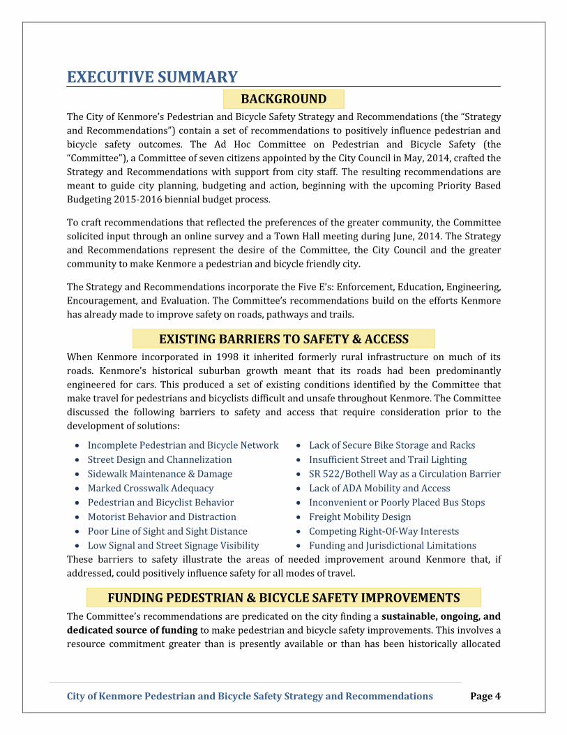
EXECUTIVE SUMMARY
BACKGROUND
The City of Kenmore’s Pedestrian and Bicycle Safety Strategy and Recommendations (the “Strategy
and Recommendations”) contain a set of recommendations to positively influence pedestrian and
bicycle safety outcomes. The Ad Hoc Committee on Pedestrian and Bicycle Safety (the
“Committee”), a Committee of seven citizens appointed by the City Council in May, 2014, crafted the
Strategy and Recommendations with support from city staff. The resulting recommendations are
meant to guide city planning, budgeting and action, beginning with the upcoming Priority Based
Budgeting 2015-2016 biennial budget process.
To craft recommendations that reflected the preferences of the greater community, the Committee
solicited input through an online survey and a Town Hall meeting during June, 2014. The Strategy
and Recommendations represent the desire of the Committee, the City Council and the greater
community to make Kenmore a pedestrian and bicycle friendly city.
The Strategy and Recommendations incorporate the Five E’s: Enforcement, Education, Engineering,
Encouragement, and Evaluation. The Committee’s recommendations build on the efforts Kenmore
has already made to improve safety on roads, pathways and trails.
EXISTING BARRIERS TO SAFETY & ACCESS
When Kenmore incorporated in 1998 it inherited formerly rural infrastructure on much of its
roads. Kenmore’s historical suburban growth meant that its roads had been predominantly
engineered for cars. This produced a set of existing conditions identified by the Committee that
make travel for pedestrians and bicyclists difficult and unsafe throughout Kenmore. The Committee
discussed the following barriers to safety and access that require consideration prior to the
development of solutions:
Incomplete Pedestrian and Bicycle Network
Street Design and Channelization
Sidewalk Maintenance & Damage
Marked Crosswalk Adequacy
Pedestrian and Bicyclist Behavior
Motorist Behavior and Distraction
Poor Line of Sight and Sight Distance
Low Signal and Street Signage Visibility
Lack of Secure Bike Storage and Racks
Insufficient Street and Trail Lighting
SR 522/Bothell Way as a Circulation Barrier
Lack of ADA Mobility and Access
Inconvenient or Poorly Placed Bus Stops
Freight Mobility Design
Competing Right-Of-Way Interests
Funding and Jurisdictional Limitations
These barriers to safety illustrate the areas of needed improvement around Kenmore that, if
addressed, could positively influence safety for all modes of travel.
FUNDING PEDESTRIAN & BICYCLE SAFETY IMPROVEMENTS
The Committee’s recommendations are predicated on the city finding a sustainable, ongoing, and
dedicated source of funding to make pedestrian and bicycle safety improvements. This involves a
resource commitment greater than is presently available or than has been historically allocated

City of Kenmore Pedestrian and Bicycle Safety Strategy and Recommendations Page 5
towards pedestrian and bicycle safety improvements. The Committee recommends that the city
continue to take advantage of grant opportunities whenever possible.
Any funding sources should provide more than a short-term boost and ensure that the
recommendations are continued and implemented for years to come. The Committee recommends
that long-term maintenance of existing and future infrastructure be included in cost evaluations.
KEY RECOMMENDATIONS
The committee developed 14 short-term recommendations that they believe are the most
important city projects and programs to move forward. They are ranked according to their priority,
although the ranking should not preclude action should the city identify a window of opportunity.
1. Invest in Additional Sidewalk and Walkway Infrastructure
2. Reduce Vehicular Speeds in School Zones by Installing Traffic Safety Cameras
3. Targeted Speed Limit Reductions on Arterial (30 MPH) and Local (20 MPH) Roadways
4. Develop a Citywide Crosswalk Policy to Install More Marked Crosswalks with
Rectangular Rapid Flash Beacons near Schools and in High Demand Areas
5. Continue and Expand Education and Awareness Programs
6. Create Actionable Neighborhood Transportation Plans in collaboration with
neighborhood residents, identifying traffic calming and other safety improvements
7. Expand Bicycle Infrastructure, including the number of bike lanes, shared roadway
markings, and secure storage facilities
8. Strategically Upgrade existing Roadway Signage with more up-to-date, highly-visible
and fluorescent signage, especially near Schools
9. Targeted Enforcement of Risky Driving Behaviors
10. Reclaim the Right-Of-Way through proactive work to clear obstructions and vegetation
11. Improve and Encourage use of the Citizen Action Request (CAR) Form
12. Work with Nearby Jurisdictions to Improve Bicycle and Pedestrian Connectivity
13. Encourage Pedestrian and Bicycle Delineation Markings on the future Tolt Pipeline
Trail and request markings on the Burke-Gilman Trail
14. Relocate or Increase Safety Conditions at Metro and School Bus Stops
Further, the city should consider longer-term infrastructure improvements to increase pedestrian and bicycle safety, including:
Construct at least one over/underpass across SR 522/Bothell Way, beginning with a study of locations at 61st, 65th, 73rd, and 80th
Widen the West Sammamish River Bridge to include a pedestrian and bicyclist facility
Complete the Tolt Pipeline Trail throughout the City
Install and Maintain Trail and Street Lighting
Evaluate Expanding Enforcement Capabilities
The Strategy and Recommendations also recommend that Kenmore work with its partners in
neighboring jurisdictions and local schools to maintain pedestrian connectivity for its residents. A
long-term and regional commitment to safety is required to achieve the City Council’s goal of zero
pedestrian and bicycle fatalities by 2025 (Resolution 14-235 adopted April 28, 2014, attached).

City of Kenmore Pedestrian and Bicycle Safety Strategy and Recommendations Page 6
I. INTRODUCTION
Purpose of the Strategy and Recommendations The residents of Kenmore value a community where they can walk, bicycle, and drive safely and
comfortably. The purpose of the Strategy and Recommendations are to recommend approaches
that can guide city planning and budgeting to better further these values. The Strategy and
Recommendations, crafted by a Committee of seven Kenmore residents, represent the desires of
the community to become more pedestrian and bicycle friendly. It also is designed to assist the city
in reaching its “Target Zero” goal of zero pedestrian or bicyclist fatalities by 2025.
The Strategy and Recommendations are consistent with the policies and guidance in the City’s
Comprehensive Plan. The Comprehensive Plan outlines objectives and policies to design roads for
use by bicyclists and pedestrians in addition to motorists. The plan’s Transportation Element
(currently being updated by the City’s Planning Commission) specifically includes guidance to move
towards multi-modal planning of the city’s transportation network.
Given that infrastructure changes do not take place overnight –
and may take years or decades – the Committee’s
recommendations will help the city prioritize improvements. As
such, it includes recommendations that involve education and
enforcement, not strictly infrastructure improvements. It
includes an actionable set of recommendations that can be
implemented to improve safety and access in our community,
while helping to accelerate the move towards multi-modal
planning and implementation.
Project Background On April 7, 2014 the Kenmore City Council authorized the
creation of the Ad Hoc Committee on Pedestrian and Bicycle
Safety. The Committee’s mandate was to update the 2013
Bicycle Strategy to include a pedestrian safety component,
creating a cohesive Pedestrian and Bicycle Safety Strategy for
the City of Kenmore. After a candidate solicitation and interview
process, the City appointed seven Kenmore citizens on May 5,
2014: Mark Abersold, Victoria Chaussee, Robert Greene, Andrea
Laltoo, Doug Levy, David Maehren, and Katrina Rose.
Goal: Target Zero
“The City Council
adopts “Target Zero” as
a goal by 2025 to have
no pedestrian or bicycle
deaths or serious
injuries as the result of
a collision with a
motorized vehicle.”
- Kenmore City Council
Resolution No. 14-235
Signed April 28, 2014

City of Kenmore Pedestrian and Bicycle Safety Strategy and Recommendations Page 7
Strategy Development Timeline
May 28, 2014- Four weekly committee meetings to discuss purpose, timeline,
June 16, 2014 barriers to pedestrian and bicycle safety, and solutions.
June 13, 2014 Online survey launched to solicit public input (114 responses received, Survey
Closed June 16, 2014).
June 24, 2014 Town Hall event organized by Committee to solicit public input; public comment
and breakout sessions.
June 26, 2014 Committee meeting to agree on a final list of core recommendations (prioritized via
email).
July, 2014 Committee staff prepares draft strategy document.
July 15, 2014 Committee attends Planning Commission meeting to discuss coordination of
recommendations.
August 13, 2014 Final committee meeting to discuss performance measures and finalize strategy
document.
September 8, 2014 Strategy document presented to City Council.
September – 2015-2016 Biennial Budget process.
October, 2014
The Committee met five times between May 28 and June 26, 2014 and discussed existing barriers to
pedestrian and bicyclist safety and the need for infrastructure, programmatic, and operational
improvements. The Committee also created an online survey and conducted a Town Hall event to
solicit additional citizen input and to ensure that their recommendations represented the
community as a whole.
In July, staff completed a draft of the Strategy and Recommendations for the Committee’s review
and final edits. The document was finalized in August, and scheduled for presentation to City
Council in early September. City staff communicated with the Committee members during the
drafting process to ensure that the document embodied the Committee’s vision.

City of Kenmore Pedestrian and Bicycle Safety Strategy and Recommendations Page 8
II. Existing Conditions & Barriers
The Problem For many years, before and after incorporation in 1998, Kenmore’s roads and walkways were
largely engineered for vehicular travel. As a result, many are not ideal for walking or bicycling.
Kenmore’s suburban characteristics mean that it lacks significant bicycle and pedestrian
infrastructure (bike lanes or striped shoulders, crosswalks, sidewalks, etc.). In recent years, vehicle
traffic through Kenmore has increased as a result of population, commercial growth, and other
factors, including tolling on SR 520. In spite of these conditions, more residents are walking and
biking around the city. This has produced a sometimes dangerous combination of heavily-trafficked
and narrow roadways being used for multiple modes of transportation. During a single week in
March 2014 there were three serious traffic collisions involving pedestrians and bicyclists. Two of
the collisions resulted in fatalities, one involving a bicyclist and another involving a pedestrian, and
the third collision resulted in a serious injury. These incidents prompted the city to create the Ad
Hoc Committee on Pedestrian and Bicycle Safety.
There is a Need for a More Walkable and Bikeable City Kenmore’s residents would like to bike and walk around their city, but they need a network of
roadways and walkways that allow them to safely travel to their destinations. As infrastructure
improvements are made, more pedestrians and bicyclists will use city streets and drivers will
become acclimated to this new environment and more likely to look out for other road users.
Kenmore is largely a bedroom community where most residents
commute outside of the city for work. The average commute time
for a Kenmore resident is nearly 30 minutes and 72% of workers
commute in a single-occupancy vehicle.1 Few people are biking or
walking to work. As 2013’s Bicycle Strategy noted, bicycling is
more likely to provide transportation for a segment of a commute
trip (from home to the park and ride, for instance). The proportion
of people bicycling to work can increase if it is deemed a safe and
convenient alternative to driving.
However, many residents do commute within Kenmore for
recreation and errands by walking or bicycling. The city is
fortunate to have great parks, like Log Boom Park and Saint
Edward State Park which both provide access to the Lake
Washington waterfront. The city is also home to a portion of the
Burke-Gilman Trail, which connects riders and runners to the
1 Source: Census Website. Commuting Characteristics by Sex, 2010-2012. American Community Survey 3-Year Estimates, Form S0801.
NE 181st Street between 68
th & 73
rd Ave NE.
City of Kenmore Pedestrian and Bicycle Safety Strategy and Recommendations Page 9
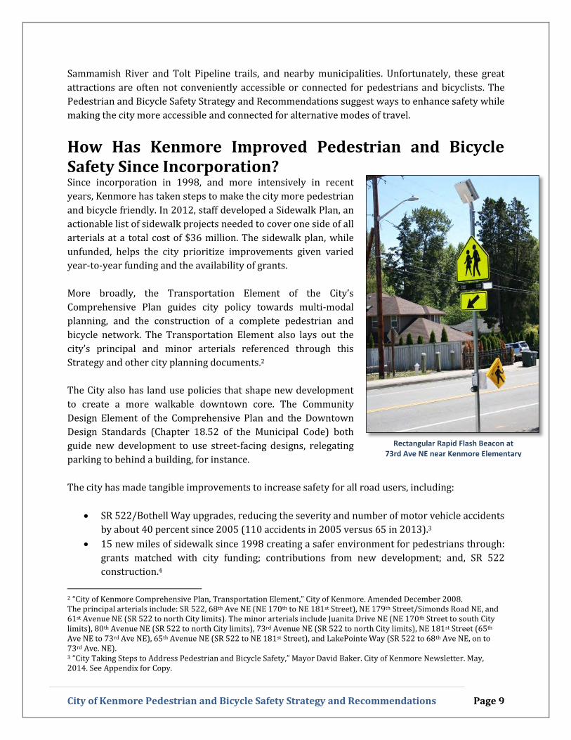
Rectangular Rapid Flash Beacon at 73rd Ave NE near Kenmore Elementary
Sammamish River and Tolt Pipeline trails, and nearby municipalities. Unfortunately, these great
attractions are often not conveniently accessible or connected for pedestrians and bicyclists. The
Pedestrian and Bicycle Safety Strategy and Recommendations suggest ways to enhance safety while
making the city more accessible and connected for alternative modes of travel.
How Has Kenmore Improved Pedestrian and Bicycle Safety Since Incorporation? Since incorporation in 1998, and more intensively in recent
years, Kenmore has taken steps to make the city more pedestrian
and bicycle friendly. In 2012, staff developed a Sidewalk Plan, an
actionable list of sidewalk projects needed to cover one side of all
arterials at a total cost of $36 million. The sidewalk plan, while
unfunded, helps the city prioritize improvements given varied
year-to-year funding and the availability of grants.
More broadly, the Transportation Element of the City’s
Comprehensive Plan guides city policy towards multi-modal
planning, and the construction of a complete pedestrian and
bicycle network. The Transportation Element also lays out the
city’s principal and minor arterials referenced through this
Strategy and other city planning documents.2
The City also has land use policies that shape new development
to create a more walkable downtown core. The Community
Design Element of the Comprehensive Plan and the Downtown
Design Standards (Chapter 18.52 of the Municipal Code) both
guide new development to use street-facing designs, relegating
parking to behind a building, for instance.
The city has made tangible improvements to increase safety for all road users, including:
SR 522/Bothell Way upgrades, reducing the severity and number of motor vehicle accidents
by about 40 percent since 2005 (110 accidents in 2005 versus 65 in 2013).3
15 new miles of sidewalk since 1998 creating a safer environment for pedestrians through:
grants matched with city funding; contributions from new development; and, SR 522
construction.4
2 “City of Kenmore Comprehensive Plan, Transportation Element,” City of Kenmore. Amended December 2008. The principal arterials include: SR 522, 68th Ave NE (NE 170th to NE 181st Street), NE 179th Street/Simonds Road NE, and 61st Avenue NE (SR 522 to north City limits). The minor arterials include Juanita Drive NE (NE 170th Street to south City limits), 80th Avenue NE (SR 522 to north City limits), 73rd Avenue NE (SR 522 to north City limits), NE 181st Street (65th Ave NE to 73rd Ave NE), 65th Avenue NE (SR 522 to NE 181st Street), and LakePointe Way (SR 522 to 68th Ave NE, on to 73rd Ave. NE). 3 “City Taking Steps to Address Pedestrian and Bicycle Safety,” Mayor David Baker. City of Kenmore Newsletter. May, 2014. See Appendix for Copy.

City of Kenmore Pedestrian and Bicycle Safety Strategy and Recommendations Page 10
Speed control measures, including deployment of permanent and temporary “Your Speed”
radar signs (permanent signs on Juanita Drive, Simonds Road and 61st Ave NE), reduced
speed limits on 80th Ave NE and SR 522, and other measures.5
In response to one bicyclist and two pedestrian fatalities between October, 2013 and March 2014,
the City of Kenmore took a number of aggressive steps to improve safety outcomes, 6 including:
The installation of 11 new Rectangular Rapid Flash Beacons (RRFB’s) at all of the city’s
arterial non-stop controlled marked crosswalks (see photo above).
The rechannelization of 61st Avenue NE and Juanita Drive NE (in progress). King County has
also designed a new striping plan for 170th Street/Simonds Road that includes a bike lane
on the uphill (south) side and bike lanes and sharrows on the downhill (north) side.
Commissioned street lighting and arterial speed limit studies.
Signal and ADA improvements on Juanita Drive NE and Arrowhead Drive (153rd), and
Juanita Drive and 170th.
Increased enforcement for violations by all road and trail users.7
City staff developed and is in the process of implementing a safety education and awareness
program.
Adoption of a “Target Zero” Resolution (14-235) by City Council on April 28, 2014.
While the city has made progress to improve pedestrian and bicycle safety through enforcement,
infrastructure, and engineering, there are a number of barriers to safety and access that still exist
throughout the city.
4 Ibid. 5 Ibid. 6 “Update on Pedestrian and Bicycle Safety,” Memo from City Manager Rob Karlinsey to Mayor and City Council. May 15, 2014. 7 See enforcement statistics as reported in “Pedestrian and Bicycle Safety Update,” City Council Business Agenda Item,
Kenmore City Council. July 14, 2014.

City of Kenmore Pedestrian and Bicycle Safety Strategy and Recommendations Page 11
Barriers to Pedestrian and Bicycle Safety and Access The first step the Ad Hoc Committee took was to identify the key barriers to safety and access in
Kenmore that should be addressed to improve safety outcomes.
Infrastructure Needs: Incomplete Pedestrian and Bicycle Network, Street Design Issues,
and Road Channelization & Curves: Kenmore recently rechannelized 61st AVE NE, is in the
process of rechannelizing Juanita Drive, and plans to rechannelize Simonds Road to provide
improved facilities for bicyclists and pedestrians. But the bike and pedestrian infrastructure on
arterials is still far from complete. The city has developed an
arterial sidewalk plan but with a price tag of $36 million for
11 miles of sidewalk, new segments are mostly built when
grants are acquired – and will take over 100 years to
complete at current funding levels. As a result, few arterials –
and even fewer local roads – have sidewalks. Additionally,
narrow roads and their natural curvatures pose design
challenges when trying to build out pedestrian and bicycle
infrastructure (68th Ave NE, etc.).
Sidewalk Maintenance & Damage: There are a number of
areas throughout Kenmore, including 61st Ave NE (see
above) and 80th Ave NE where the sidewalks have been
damaged either by tree growth or other causes. Damaged,
undulating walkways pose risks for all pedestrians and
bicyclists. There are no city funds annually designated
toward sidewalk maintenance.
Marked Crosswalk Adequacy in High-Demand Areas: The city’s marked crosswalks are not
located in high-demand areas or are inconveniently spaced out, leading pedestrians to jaywalk.
Existing crosswalks are concentrated at large intersections with longer crossing distances than
a midblock crosswalk might contain. Kenmore has no crosswalk policy.
Pedestrian and Bicyclist Behavior: The behavior of both pedestrians and bicyclists
contributes to unsafe conditions in Kenmore. Some pedestrians and bicyclists are not easily
visible because they are either wearing dark clothes, not using required bike lights, or other
reflective visibility gear. Other behaviors, like being distracted and not wearing helmets,
going too fast and not obeying traffic laws, increase the odds of a crash and serious injury.
Driver Behavior: With the proliferation of smart phones, drivers are more distracted than
ever. Distracted driving – including eating, putting on makeup, reading, and texting - leads to
carelessness on the road and endangers others. Drivers who perform “visual-manual” tasks
Sidewalk on 61st
Ave NE

City of Kenmore Pedestrian and Bicycle Safety Strategy and Recommendations Page 12
associated with their cell phone are three times more likely to be in an accident.8 A host of other
dangerous driving acts, including a lack of yielding to pedestrians and bicyclists, driving on
the shoulder, and speeding on arterials – in school zones, and when traveling through
neighborhoods – pose risks to safety.
Poor Line of Sight, Sight Distance, and Poor Signal and Signage Visibility: The design of
many of Kenmore’s roads creates line of sight issues that limit signal, signage and driveway
visibility. These problems may be attributed to sign placement and road curvatures, but some
are a result of preventable and manageable vegetation overgrowth.
Lack of Secure Bike Storage and Bike Racks: As Kenmore’s 2013 Bicycle Strategy noted, the
low number of bicycle storage facilities along SR 522 poses a barrier to commuting via bicycle.
The 12 bike lockers and 4 eLockers9 located at Kenmore Park and Ride are at full capacity. The
Committee also noted the lack of well-maintained bike racks near businesses and parks.
Insufficient Street and Trail Lighting: Not all arterials in Kenmore have consistent street
lighting – it is either missing, not functioning (burnt out), or blocked by vegetation. Lighting
improves visibility which improves safety for all road users. There is currently no street lighting
on trails.
SR 522/Bothell Way: SR 522 cuts Kenmore in half
to create a north-south divide that is both a
psychological and geographic barrier for the
community. The highway has increasingly high
traffic volumes from regional commuters and safe
and comfortable crossing points for pedestrians and
bicyclists are few and far between.
Lack of ADA Mobility & Accessibility: Kenmore’s
lack of a complete network of sidewalks disproportionally impacts residents with disabilities.
Existing pedestrian facilities are not always ADA compliant because they were designed before
ADA compliance was required. Many arterials without sidewalks or shoulders are inaccessible
to residents with disabilities.
King County Metro, Sound Transit and School Bus Stops: The location of bus stops around
the city poses safety hazards because of their combination with other barriers: a lack of lighting,
poor line of sight, and they may not be located near marked crosswalks or along walkable roads.
8 “The impact of hand-held and hands-free cell phone use on driving performance and safety-critical event risk.” Fitch, G. A., Soccolich, S. A., Guo, F., McClafferty, J., Fang, Y., Olson, R. L., Perez, M. A., Hanowski, R. J., Hankey, J. M., & Dingus, T. A. (2013, April). (Report No. DOT HS 811 757). Washington, DC: National Highway Traffic Safety Administration. Source URL: http://www.vtti.vt.edu/featured/052913-cellphone.html. 9 Bike Parking at Transit Facilities. King County Metro Transit. http://metro.kingcounty.gov/tops/bike/parking.
SR 522/Bothell Way

City of Kenmore Pedestrian and Bicycle Safety Strategy and Recommendations Page 13
Freight Design Standards and Routes: Kenmore’s roadways must accommodate freight
movement. Freight is largely found on SR 522, Simonds Road, 61st AVE NE, 68th Ave NE, and
175th Street NE – though all arterials are designated as freight routes in the Comprehensive
Plan. The road standards used for freight (large turning radii) can conflict with ideal pedestrian
and bicycle facilities.
Competing Right-of-Way Interests: Stormwater infrastructure such as open ditches requires
City right-of-way. It is not uncommon for the road edge to be close to a ditch, which leaves little
to no room for pedestrians and bicycles. Other right-of-way interests include parking,
landscaping, and utility needs which can inhibit pedestrian and bicycle walkways.
Future Funding and Jurisdictional Limits and Boundaries: Kenmore’s desire to take
additional steps to positively increase safety is not consistent with current levels of funding for
infrastructure improvements. Additionally, the city’s location subjects it to the detrimental
effects of regional traffic trends, which pose challenges for long-term planning. There are
jurisdictional challenges as well, due to multiple Kenmore schools falling right on the edge of
the city (Inglemoor High School and Kenmore Junior High). Further, unlike in King County,
neighboring Snohomish County does not have a helmet requirement for bicyclists.
The barriers to safety and access identified by the Committee are important starting points to help
frame the challenges facing the City of Kenmore. The array of barriers suggests that engineering
and new infrastructure cannot solve problems of pedestrian and bicycle safety alone. A successful
path forward must involve a range of strategies that incorporate the 5 E’s: Enforcement, Education,
and Engineering, Encouragement, and Evaluation.

City of Kenmore Pedestrian and Bicycle Safety Strategy and Recommendations Page 14
III. Recommendations to Improve Pedestrian and Bicycle Safety
The Committee has developed a series of short-term and long-term
recommendations to be taken into consideration by the City of Kenmore
that address the barriers to safety and access outlined above.
Short-Term Recommendations 0 to 2 Years
The Committee has prioritized 14 recommendations that the City should consider, fund and
implement. These recommendations can be implemented in a short timeframe, though they may be
ongoing in nature and require continued funding. While they are prioritized based on the
Committee’s ranking of their importance, staff and council are encouraged to pursue lower-priority
recommendations as resources and circumstances allow. It is not the Committee’s intent that
Recommendation 1 be completed before moving down the list. Instead, the Committee encourages
the city to identify projects that provide a combination of increased safety and the best cost-benefit
return on investment.
Recommendation 1: Invest in Additional Sidewalk and Walkway Infrastructure
The Committee believes Kenmore’s highest priority should be creating and connecting
more sidewalks and walkways on key corridors and around Kenmore’s schools. Where
consistent with current design standards, the city should closely examine cost-effective
alternatives to traditional sidewalks, including large shoulders and shoulders separated
from the roadway by curbing. The existing Sidewalk Plan is a great inventory of arterial
sidewalk needs, but it should be expanded to included non-arterial missing links. Often
there is a gap in sidewalks from an arterial to a particular neighborhood and these are not
accounted (or planned) for currently in the Sidewalk Plan.
Kenmore must also commit sufficient resources to maintaining its existing sidewalks.
Dangerous conditions arise when sidewalks are not properly maintained. A significant
increase in funding is needed to make this recommendation a reality.
Recommendation 2: Reduce Vehicular Speeds in School Zones by Installing Traffic Safety
Cameras
The city should focus on reducing vehicle speeds on streets surrounding schools by
installing automated traffic safety cameras. Traffic safety cameras will increase safety levels
around Kenmore’s most vulnerable residents and reinforce that the city is serious about
assuring bicycle and pedestrian safety. Protecting our children has been a consistent
message received through the Committee’s outreach efforts. The committee recommends
that revenues from the traffic safety cameras be dedicated to fund traffic safety programs
and improvements.

City of Kenmore Pedestrian and Bicycle Safety Strategy and Recommendations Page 15
Recommendation 3: Targeted Speed Limit Reductions on Arterials and Local Roadways
The Committee recommends reducing speeds to 30 MPH on arterials and 20 MPH on local
streets, where appropriate. In certain instances, Kenmore should use other means to lower
the speeds (enforcement, engineering, etc.) where lowering the speed limit alone is
insufficient. Neighborhood Transportation Plans (Recommendations Number 6, below) are
also a way for the community to identify local roadways where lower speed limits may
improve safety.
At the July 14, 2014 City Council meeting, the Council left arterial speed limits at 35 MPH
following a King County traffic engineer’s study of all arterial speed limits. Nonetheless, the
Committee believes the city should focus on reducing speed limits on all streets as a means
to improve safety, reduce the severity of accident injuries and to send a clear and visible
message that the city is serious about bicycle and pedestrian safety.
Recommendation 4: Develop a Citywide Crosswalk Policy to Install Additional Marked
Crosswalks with RRFB’s
The City of Kenmore should develop a citywide crosswalk policy in order to have a clear
process for determining where new marked crosswalks should be installed. The Committee
recommends that, where merited, additional marked crosswalks with Rectangular Rapid
Flash Beacons (RRFB’s) should be installed near schools and other highly-trafficked
areas. This will bring heightened attention to pedestrians and cyclists crossing the street.
The city should continue its current work installing RRFB’s at all non-stop controlled
marked crosswalks to ensure that new crosswalks are as safe as possible.
The city can draw on community involvement (via the Neighborhood Transportation Plans)
to identify crosswalk locations, and work on innovative ideas like crosswalk art programs,
where volunteers, children or artists decorate crosswalks with long-lasting murals.
Recommendation 5: Continue and Expand Education & Awareness Programs
Kenmore should continue and expand its education and awareness program launched in
2014 with the primary goal of creating a culture of respect for pedestrian and bicycle
safety. This messaging could be similar to the ‘Courtesy is Contagious’ campaign during the
city’s first years of incorporation. Education and outreach activities provide the opportunity
to inform the public about the importance of pedestrian and bicycle safety, existing

City of Kenmore Pedestrian and Bicycle Safety Strategy and Recommendations Page 16
enforcement measures, and ways they can help create a safer city that respects all modes of
transportation. Educational programs will be more effective when there is sound and
consistent messaging across all agencies. The committee’s education and outreach
recommendations are organized as follows:
Establish an Interagency Education Coalition: Kenmore contains a number of
institutions and organizations that can be leveraged to create coordinated and ongoing
outreach campaigns. The Northshore Fire Department, the Northshore Utility District,
Safe Kids Eastside, the Northshore School District, PTA’s, and church and senior citizen
groups are valuable organizations who the city should work with to maximize outreach
efforts in order to reach as many citizens as possible.
Use Multiple Distribution Streams to Disseminate Educational Materials: The
above coalition should work together to spread the safety message to a wide audience
through social media, events, in classrooms, newsletters, and face-to-face presentations.
Educational Programming: The coordinated programming should include information
how to be safe bicyclists, pedestrians, and drivers, including proper visibility gear and
being aware of environmental changes like daylight savings time. Education should also
inform the public about other ways to increase citywide safety. This includes
information about the Citizen Action Request process, ways to request street lighting
repairs, and regulations regarding right-of-way, vegetation, and sidewalk maintenance.
Connect Education with Engagement Programs: Pair educational outreach with
programs that can improve pedestrian and bicyclist safety, including “Adopt a
Crosswalk” programs, helmet fitting and reflective and wearable lighting gear
distribution.10
Recommendation 6: Create Actionable Neighborhood Transportation Plans
Neighborhood Transportation Plans utilize neighborhood volunteers to identify and
prioritize traffic safety issues. These groups then work with the city to find and
implement solutions. Solutions may involve enforcement, signage, new crosswalk
locations, traffic calming installations, or sidewalks. Traffic calming devices often
include traffic circles, raised crosswalks, or speed bumps. Ultimately, these plans can assist
in other portions of the Strategy and Recommendations, such as updating the Sidewalk Plan.
By developing an up-to-date inventory of issues, the city can identify grants that may fund a
particular safety improvement. Other nearby municipalities have adopted similar programs,
including Shoreline and Kirkland.11
10 See Appendix item “Full List of Barriers and Solutions” for additional education recommendations and ideas. 11 Information on the City of Shoreline’s Neighborhood Traffic Management Program can be found here: http://www.cityofshoreline.com/government/departments/public-works/traffic-services/neighborhood-traffic-action-plans. The City of Kirkland’s pilot program can be found here: http://www.kirklandwa.gov/depart/CMO/Neighborhood_Services/NSP.htm.

City of Kenmore Pedestrian and Bicycle Safety Strategy and Recommendations Page 17
Recommendation 7: Expand Bicycle Facilities
The city should invest in additional bike facilities (bike lanes,
marked shoulders, separated pathways) on key arterials
(61st, 80th, Simonds Road, Juanita Drive, and 73rd) and
construct additional bicycle storage racks and other
installations throughout the city to make bicycling more
convenient and safe. The Committee suggests that the city
use the Bicycle Strategy as a guide when building additional
bicycle facilities.12
Increasing the number of bicycle racks (including artistically-
styled bike racks) available outside local businesses and on
public and school district property should also be a high
priority. Installing additional storage lockers at the Kenmore
Park and Ride, for instance, can encourage more people to
make cycling a part of their daily commute. Additionally, the
City should work to ensure that existing bike racks around
the city are properly maintained.
Additional bike facilities, storage areas, and other installations, like bike rails (which allow
riders to rest at an intersection without having to disembark from their bike), will have a
safety enhancing effect by making bicycling more common, thereby improving safety.
Recommendation 8: Strategically Upgrade Existing Roadway Signage
The City should make strategic upgrades to existing roadway signage by replacing out-of-
date signage with more visible fluorescent signage whenever possible. Modern, fluorescent-
colored signs are more effective at catching the eye of drivers. The city should ensure that
signage is visible and complete, especially in school zones. The Committee also recommends
adding flashing school zone lights at Kenmore Junior High.
Recommendation 9: Targeted Enforcement
Kenmore’s Police Department should adopt an enforcement strategy focused on risky
driving behaviors, such as speeding, distracted driving, driving on the shoulder, following
too closely, and failure to yield. The department should enforce a zero tolerance policy for
making an initial stop with regard to all road users. The police department should also
continue enforcing rules for pedestrians and bicyclists – such as jaywalking, speeding
cyclists on the city’s trails, not stopping at stop signs, and bicycle helmet use.
12 See the Appendix for relevant portions of the City of Kenmore’s Bicycle Strategy, prepared by a citizen committee and approved by the City Council in 2013.
Example of a bike lane on NE 80th
Ave

City of Kenmore Pedestrian and Bicycle Safety Strategy and Recommendations Page 18
Recommendation 10: Reclaim the Right-of-Way
The City should reexamine its policy regarding how it keeps the city’s right-of-way clear.
Ensuring that bike paths and pedestrian walkways are clear from debris, improperly parked
vehicles, vegetation, and other hazards, may involve the City taking on a more proactive
role. Existing policy largely relies on property owners and takes a reactive approach to
improvements. As a result, many shoulders available for bicyclists contain hazardous debris
(gravel along 68th Ave NE between 182nd and 185th Street, for example). As referenced
above, educating the public about their duty as property owners should also be a priority.
This recommendation is consistent with Policy T-1.2.3 of the Comprehensive Plan, which
states that the Kenmore should “Maintain right-of-way and design standards that
accommodate non-motorized transportation facilities to create a pedestrian and bicycle
network in the community.”
Recommendation 11: Improve and Encourage Use of the Citizen Action Request System
The Citizen Action Request (CAR) form is a convenient way for residents to report
maintenance needs to city staff. There is currently low knowledge within the community
that the CAR exists and what it should be used for. The CAR form should be surfaced on the
city’s homepage to make it more visible, made anonymous,13 and citizens should be able to
attach a photograph to their online request. Further, the city should educate and encourage
citizens to use the form. Vegetation, sidewalk maintenance, and other issues can be brought
to the city’s attention and repaired via the CAR process.
Recommendation 12: Work with Nearby Jurisdictions to Improve Bicycle and Pedestrian
Connectivity
Pedestrian and bicycle safety is a regional issue and should be treated as such. The City of
Kenmore should coordinate with neighboring municipalities and jurisdictions like the cities
of Bothell and Kirkland, and Snohomish County when selecting sites for safety
improvements and other infrastructure projects, in order to ensure network connectivity.
Such communication is especially important for areas surrounding schools like Inglemoor
High School, Lockwood Elementary, and Kenmore Junior High.
This recommendation is consistent with Objective T-4.2 of the Comprehensive Plan, to work
with neighboring jurisdictions “to address regional transportation issues.”
Recommendation 13: Encourage Pedestrian and Bicycle Delineation Markings on Trails
The City should work to include pedestrian and bicycle delineation markings on the future
Tolt Pipeline Trail in order to minimize pedestrian-bicycle conflict. Further, the city should
13 A Citizen Action Request can currently be filed anonymously using a paper form, however the online form on the city’s website requires a name and contact information.

City of Kenmore Pedestrian and Bicycle Safety Strategy and Recommendations Page 19
request that King County mark the portion of the Burke-Gilman Trail that runs through
Kenmore with designated pedestrian and bicycle lanes.
Recommendation 14: Metro and School Bus Stop Improvements
The King County Metro and Sound Transit bus stop locations around Kenmore pose
problems for traffic congestion and pedestrian connectivity and the City should work more
closely with transit agencies to either move stops to better locations near pedestrian
crossings where they will not inhibit traffic flow or improve the surrounding infrastructure.
The city should continuously work with Northshore School District to identify ideal
locations for bus stops. Bus stops should be located at well-lit locations with clear lines of
sight, areas for students to stand and wait, and safe walking routes to and from their homes.
These recommendations address the Five E’s from different angles by balancing new infrastructure
and engineering improvements while encouraging citizens to make behavioral changes to increase
safety for motorists, bicyclists, and pedestrians.
Medium to Long-Term Recommendations 2 to 6+ Years
Other improvements that can positively influence pedestrian and bicycle safety require longer
build-out and planning periods, higher costs, and stakeholder buy-in. They should be evaluated
within the context of Capital Improvement Program as part of the city’s biennial budget process.
Construct an Over/Underpass across SR 522/Bothell Way
At least one grade separated crossing (an overpass or a
tunnel) across SR 522 would provide connections to the
Burke-Gilman Trail and the waterfront for the
community north of SR 522 and connections to the
downtown core for residents south of the highway. This
long-term and resource-intense investment should begin
with a study that identifies possible locations. The
Committee suggests that an initial review include
crossings of SR 522 at 61st, 65th, 73rd, and 80th.
Provide an Improved Bicycle and Pedestrian Facility on the West Sammamish River Bridge
Both the North and South sides of the West Sammamish River Bridge currently have narrow
walkways for pedestrians and are difficult for bicycles to pass across. When the city
reconstructs the West Sammamish River Bridge, it should include separated pedestrian and
bicycle facilities. Ultimately, the city should work to include improved facilities on both
sides of the bridge.
North Side of Sammamish River Bridge

City of Kenmore Pedestrian and Bicycle Safety Strategy and Recommendations Page 20
Complete the Tolt Pipeline Trail through Kenmore
Completing the portion of the Tolt Pipeline Trail that runs through Kenmore to include a
pathway for bicyclists is a great way to increase east-west pedestrian and bicyclist
connectivity through North Kenmore while providing an additional connection to nearby
municipalities, like Bothell and Woodinville. The Capital Improvement Program includes
completion of a portion of the trail from 68th Ave to 73rd Ave, currently in design.
Install and Maintain Trail and Street Lighting
Lighting should be added to the city’s main trails, including the
Wallace Swamp Creek, Tolt Pipeline, and Burke-Gilman Trails.
This medium-term recommendation should also include
working with the Neighborhood Transportation Plans to
inventory areas where additional street lighting would most
beneficially impact pedestrian and bicyclist safety.
Enforcement Capabilities
The City of Kenmore implemented an increased enforcement
strategy in response to recent pedestrian and bicycle fatalities.
This initial response utilizes overtime to increase the law
enforcement presence. The committee recommends evaluating
the effectiveness of the increased enforcement and if effective,
examining the hiring of an additional Traffic Enforcement
Officer. The additional officer will assure that the emphasis can
be maintained long-term and that a culture of enforcement
exists in the City of Kenmore.
Funding Pedestrian and Bicycle Safety Improvements Ongoing
The above recommendations can help guide Kenmore toward becoming a more bicycle and
pedestrian friendly city. The cost involved in some of the improvements, particularly the
infrastructure improvements, is significant and higher than what has historically been allocated to
pedestrian and bicycle safety issues.
The city should secure a long-term, ongoing, sustainable, and dedicated pedestrian and bicycle
safety funding source to ensure that different aspects of the above recommendations continue to be
implemented and maintained for years to come. The Committee suggests that the city consider the
following funding categories in relation to the above recommendations:
Capital Expenditures: Significant monetary resources are needed for short-term and long-
term infrastructure improvements, including the construction of new sidewalks and the SR
522/Bothell Way over/underpass.
Portion of Tolt Pipeline Trail, Looking East at 73
rd Ave NE

City of Kenmore Pedestrian and Bicycle Safety Strategy and Recommendations Page 21
Operational Expenditures: The city will need to set aside ongoing operational funds to
carry out many of the above recommendations. For instance, ongoing staff resources will
need to be dedicated to maintain right-of-way, vegetation, and sidewalks, in addition to
funding additional enforcement as referenced above.
Programmatic Expenditures: The city should fund programmatic safety improvements,
including the Neighborhood Transportation Plans (both administration and funding for
improvements) and educational and awareness programs.
While the Committee finds that an ongoing and sustainable funding stream is important, the city
should still continue to leverage such funding by seeking out grant opportunities, as it has
historically done to fund new sidewalk construction.

City of Kenmore Pedestrian and Bicycle Safety Strategy and Recommendations Page 22
IV. Performance Measures
The Pedestrian and Bicycle Safety Strategy and Recommendations include improvements that will
positively impact road and trail safety in Kenmore. It is important for the city to monitor whether
or not these recommendations, once implemented, are positively affecting safety outcomes. The
below performance measures will provide insight into whether the recommendations, working
together, are improving safety, and if they are not – guide the city to change course.
These measurements are meant to cover more than one recommendation and there may not be a
measurement for each individual recommendation. Instead, these are meant to holistically measure
the effectiveness of the City’s efforts.
Collecting the data necessary to fulfill these measurements may require a range of data collection
techniques including volunteers monitoring behavior in person or via a camera or aggregating data
from existing collision databases.
BEHAVIOR, EDUCATION & ENFORCEMENT MEASUREMENT Frequency/Locations Motorist Yield Rate: The percentage of motorists yielding to pedestrians in
crosswalks when pedestrians have the right-of-way (up to several locations)
2 times per year
Reflective & Lighting Gear Usage Rate: The percentage of pedestrians and
bicyclists using reflective or high-visibility gear (up to several locations)
2 times per year
Crossing Flag Usage Rate: The percentage of pedestrians using pedestrian
crossing flags when crossing the street (up to several locations)
2 times per year
Helmet Usage Rate: The percentage of bicyclists using helmets (up to several
locations)
2 times per year
Enforcement Report: Document to the extent possible the location and number
of enforcement stops and enforcement action concerning traffic safety
violations by motorists, bicyclists, and pedestrians
1 time per year
Collision Report: Number and location of traffic collisions involving pedestrians
or bicyclists
1 time per year
Number of K-12 Students and Adult Community Members Receiving Safety
Education from City Staff or Volunteers
Yearly
ENGINEERING & INFRASTRUCTURE IMPROVEMENTS MEASUREMENT Frequency/Locations
School Zone Speed Studies to measure 85th percentile speed reduction (up to
several locations)
Yearly
Capital Improvement Dollars Managed for Pedestrian and Bicycle Safety
Improvement Projects
Yearly
City of Kenmore Pedestrian and Bicycle Safety Strategy and Recommendations Page 23
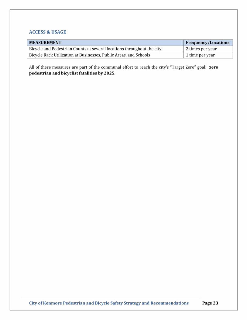
ACCESS & USAGE
MEASUREMENT Frequency/Locations
Bicycle and Pedestrian Counts at several locations throughout the city. 2 times per year
Bicycle Rack Utilization at Businesses, Public Areas, and Schools 1 time per year
All of these measures are part of the communal effort to reach the city’s “Target Zero” goal: zero
pedestrian and bicyclist fatalities by 2025.

City of Kenmore Pedestrian and Bicycle Safety Strategy and Recommendations Page 24
IV. Conclusion
The recommendations outlined above will positively influence safety outcomes for all pedestrians,
bicyclists, and motorists in Kenmore. The implementation requirements for each vary in their
required levels of funding and staff resources, but together provide a holistic outline for how to best
move forward. The focus on educational and awareness programs balance the long-term (and more
costly) infrastructure investments to improve pedestrian and bicycle safety outcomes.
While Kenmore has made improvements to improve safety on city roadways since incorporation,
the Committee’s recommendations are designed to provide the outline for an actionable plan to
improve bicycle and pedestrian safety that will result in substantially more progress in the coming
years.

Appendix 1:
Barriers and Solutions Worksheet
Pedestrian & Bicycle Safety Committee Worksheet:Barriers & Solutions
BEHAVIOR
SAFETY BARRIER: Pedestrian and Bicycle Behavior
Description of Barriers: The committee has identified barriers to safety relating to pedestrianand bicycle behavior, including low visibility of pedestrians,pedestrians who are not actively paying attention, bicyclists who arenot wearing helmets, and long pedestrian signals.
Proposed Solutions:
1. EDUCATION: Implement an Interagency Education and Awareness Program that leverages thecity’s resources with other agencies, like the Fire Department, PTA groups, City Schools, SeniorCitizens, Churches, etc. The education and awareness package may include:
1) Information about how pedestrians and bicyclists can be more visible to cars and thedangers of texting and walking;
2) Information regarding the importance of helmets, how to properly wear them, andvolunteers or city staff that can properly fit the helmets;
3) Educate citizens that the city of Kenmore does not control most of the signals in theircity and how to report signal issues to WDOT.
4) Education about how to bring problems to attention of the city (CARs).
This information could be distributed in the following ways:
1) Law enforcement or city staff speaking to specific neighborhood groups;2) School resource officers speaking with students;3) City newsletter to promote safety information on a regular basis;4) Posters displayed in local businesses about bicyclists and pedestrian safety;5) Use the city’s social media feeds;6) One or more new community message boards around the city;7) Create internship opportunities for students to educate other students;8) Fire Department “Bring your helmet to school day” to instruct students on how to wear
a helmet correctly.
2. Implement signage at the entrance of King County that reads: “Helmets are Mandatory.”3. Encourage law enforcement to enforce existing rules for all road users.4. Distribute, for a small fee or no fee, brightly colored backpacks and reflective gear to kids at
Back-to-School events and other citizens.5. Create an “Adopt a Crosswalk” program where neighborhood volunteers monitor flag inventory
and issues with crosswalks.6. Always include fitting with helmet distribution to reduce liability and make helmets more
comfortable to wear.7. Join Safe Kids Eastside to expand the resources available for helmet distribution.

SAFETY BARRIER: Driver Behavior
Description of Barrier: Cars Not Yielding or Looking for PedestriansCars Are Traveling Too Fast
Proposed Solutions:
1. Multi-Modal Neighborhood Transportation Plans: create neighborhood plans where citizenshelp to plan or recommend traffic safety improvements in their neighborhoods. These plansmight include: traffic calming strategies, such as raised crosswalks, roundabouts, etc.
2. Implement traffic safety cameras at the 3 elementary schools with the surplus revenuegenerated to fund pedestrian and bicycle safety improvements.
3. Gateway Signage: Build a gateway sign that is visible upon entry into Kenmore thatcommunicates our commitment to safety for all road users.
4. Foster Cultural Changes: Pedestrian and bicyclists are equal to cars and that cars, pedestriansand bicyclists will be ticketed in Kenmore if they do not abide by laws. Create a zero tolerancepolicy regarding speeding.
5. Encourage the city to work with neighboring law enforcement to decrease distracted drivingthrough enforcement, education and awareness public service announcements.
6. Increased enforcement in key areas, such as around schools, looking for speeding, distracteddriving, and other dangerous behaviors.
7. Make school zones 24-hours; install red light cameras at school zones and on downhill slopes ofarterials to ticket speeders.
8. Conduct a broad review of neighborhood speed limits to determine where speeds could belowered.
9. Educate citizens on the benefits of pedestrian and bicycle safety features available in newervehicles.
10. Educate citizens regarding the CAR; Encourage business owners and employees who travelabout Kenmore to report issues.

4-
INFRASTRUCTURE NEEDS
SAFETY BARRIER: Incomplete Pedestrian and Bike NetworkStreet Design IssuesRoad Channelization & Curves
Proposed Solutions:
1. Provide designated pathways and sidewalks for pedestrians and bicyclists on all of the mainarterials.
2. Develop non-arterial routes for the bike and pedestrian network, connections through parks,trails and other short-cuts, such as the Tolt Pipeline Trail.
3. Construct additional sidewalks in areas near schools, specifically, a policy of pathways andsidewalks within one-half road miles of all of the city’s schools.
4. Utilize the Neighborhood Transportation Planning groups to identify areas where improvementscan be made, including marked crosswalks on major corridors, curbing, and otherimprovements.
5. Identify existing roadways that are not in step with the most recent design standards.6. [valuate an additional crossing over Sammamish River for pedestrians and bikes.7. Add way-finding signage for pedestrians and bicyclists.8. Develop walking and bicycle routes where people expect to see non-motorized traffic; tie into
downtown development, parks and recreation plans.
SAFETY BARRIER: Insufficient Street and Trail Lighting
Proposed Solutions:
1. Utilize Neighborhood Transportation Planning groups to identify areas where additional streetlighting would improve safety.
2. Increase the scope of the arterial cross walk lighting survey to include all arterial roads lookingat the proposed new uses including bicycle lanes, new sidewalk segments and new crosswalklocations.
3. Consider adding lighting to high-demand trails and pathways, including the Wallace SwampCreek trail and the Tolt Pipeline trail.
4. Education: Use the newspaper and other distribution streams to inform Kenmore’s citizens onhow to report burned out street lights.
5. School Bus Stops: Coordinate with Northshore School District to locate bus stops under streetlights, make sure streetlights are working, giveaways of reflectors/lights.

SAFETY BARRIER: Lack of ADA Mobility & Accessibility
Proposed Solutions:
1. Identify where the old non-ADA compliant walkways exist. Use volunteers to find and evaluatelocations with the greatest ADA need and establish a work plan to improve the deficiencies.
2. Construct a new standard for the city that recognizes that ADA accessibility is the highestpriority, which should be reflected in minimal obstructions in the traveled portion of thesidewalks and walkways.
SAFETY BARRIER: Lack of Secure Bike Storage and Locks
Description of Barrier: The lack of bike storage is a barrier that discourages more bike-riding inKenmore.
Proposed Solutions:
1. The city should work with businesses to help enhance or create bike storage at existinglocations, for instance, by co-sponsoring promotional programs to place bike racks and storageareas on-site at businesses and at highly-used facilities.
2. Change city by-laws to require that new retail and multi-family construction include secure on-site bicycle storage.
3. Solicit Sound and Metro transit for more bike lockers and racks (see if county and state canprovide these) at local park and ride.
4. Investigate whether a local business may be able to install more of these facilities aroundKenmore (outside of park and ride).
SAFETY BARRIER: SR 522
Description of Barrier: SR 522 splits the community and the high traffic volume and high speedof cars is a safety hazard for Kenmore’s residents. Frequent commercialdriveways, congestion, and the lack of design authority all contribute toan unsafe environment.
Proposed Solutions:1. Construct a bicycle- and pedestrian-only overcrossing or tunnel in a safe and convenient area
across the highway. Possible locations: 65th or 1815tor731.
2. Consider narrowing SR 522 when coming into Kenmore (Dividers like Bothell)3. Complete the SR 522 upgrades as planned for the west section of SR 522.4. Evaluate the cost and value to the community of a grade-separated crossing and how future
development in DT Kenmore can contribute to funding of a grade separated crossings of SR 522through impact fees.
5. Evaluate the option of a signalized crossing at 61st Street & SR 522. [might have been 65th1

OPERATIONS & MAINTENANCE
SAFETY BARRIER: Poor Line of Sight andPoor Signal and Signage Visibility
Description of Barrier: Existing signage and intersection design create safety hazards whereinthere is poor line of sight to other road users and poor visibility of signsand signals.
Proposed Solutions:
1. Use the Neighborhood Transportation Planning groups to locate areas where vegetation aroundcritical intersections and signage poses a threat to safety.
2. Educate citizens and businesses about how to file Citizen Action Request forms related to line ofsight issues; create anonymous reporting tool; encourage its use.
3. Implement additional Rectangular Rapid Flashing Beacon (RRFB) lights at crosswalks, andadditional flashing signals (similar to those on Juanita Drive).
4. Manage street trees: Only plant street trees that can be managed in the long-term and onlywhere they do not block lines of sight.
5. Use fluorescent road signs more often that may be more effective at getting the attention ofdrivers.
SAFETY BARRIER: Sidewalk Maintenance & Damage
Proposed Solutions:
1. Utilize Neighborhood Transportation Planning groups to collect data to create a city map thatshows the location of every crosswalk, Metro or Sound Transit bus stop, school bus stop,sidewalk, paved shoulder with reflectors, paved shoulder with a curb buffer, bike lane, sharrow(shared-lane marking), and other pedestrian/bicycle feature to see where the city currentlystands, and to map improvements.
2. Utilize Neighborhood Transportation Planning groups to survey the existing sidewalk and trailnetwork to identify hazards.
3. Educate citizens regarding the Citizen Action Request form.4. Evaluate the requirement and possibly look at alternatives to existing policy that places the
burden on adjacent property owners for maintenance of city right-of-way sidewalks.5. Evaluate the requirement that trees be planted along sidewalks.6. Establish and fund a regular maintenance plan for city sidewalks that includes volunteers, city
crews, and property owners.

ROAD DESIGN
SAFETY BARRIER: Freight Design Standards and Routes
Proposed Solutions:
1. Encourage use of pedestrian refuges to decrease pedestrian crossing distance.2. Coordinate with business community to verify need for large freight trucks.3. Limit freight based on road design (i.e., narrow bridges/roads off-limits for freight).4. Ensure that turning radii on arterials are wide enough to prevent freight tires from going up on
curbs and design freight roads to balance pedestrian and freight needs. Do not overdesign roadsto accommodate freight.
SAFETY BARRIER: Citywide Site Distance Issues
Proposed Solutions:
1. Do not plant street trees that will interfere with sight distance or that can’t be properlymanaged over the long-term.
2. Education citizens and businesses about Citizen Action Requests.3. Design standards review of existing roads, or problematic roads (Neighborhood Transportation
Plans).
SAFETY BARRIER: Marked Crosswalks are not located in High Demand Areas
Proposed Solutions:
1. Conduct surveys and traffic studies to determine high use routes.2. Review all existing crosswalks to verify that they are in areas where the demand exists.3. Coordinate with neighborhoods and Northshore School District staff to determine where the
most traffic volume is.4. Create a task force of one city staff member and community volunteers that are similar to the
Task Force Ad Hoc Committee but would work with the city on an ongoing basis.5. Create a city map that shows the location of every crosswalk, Metro bus stop, school bus stop,
sidewalk, and paved shoulder with reflectors, paved shoulder with a curb buffer, bike lane,sharrow, and other pedestrian/bicycle feature to see where we are at currently and as aresource for public meetings.

OTHER BARRIERS
SAFETY BARRIER:
Description of Barrier:
Proposed Solutions:
TRANSIT: KC Metro, Sound Transit and School Bus Stops
Bus stops around the city may be unsafe to do their placement,surrounding traffic conditions, lack of lighting and low visibility.
1. Education: Educate citizens about how to contact Metro and Sound Transit staff with issuesconcerning bus stops
2. Improve design of pedestrian crossings to better accommodate transit users (e.g. walk signalbuttons tend to be far from bus stops so that multiple buses may pull in without blocking theintersection - maybe add a button at the bus stop to decrease pedestrian delay, or locate atunnel/bridge where it would be convenient to many transit users).
3. Use the Neighborhood Transportation Planning groups to identify bus stops requiringimprovements or those that are a safety risk.
SAFETY BARRIER:
Description of Barrier:
Proposed Solutions:
Future Funding & PlanningJurisdictional Limits and Boundaries
There are not enough funds for sidewalks and bicycle facilities, andother safety improvements.
1. Work to find a sustainable funding source for pedestrian and bicycle safety.2. Create a system where city staff regularly stays in contact with their counterparts in City of
Bothell Public Works, the City of Kirkland Public Works, Snohomish County Public Works, andother adjacent municipalities to discuss relevant road and transportation projects at theirrespective borders and ensure connectivity of bike and pedestrian networks especially aroundschools.
3. City should liaise with Snohomish County, Briar, Bothell and other municipalities on pedestrianand bicycle connectivity.

Appendix 2:
Memo to Council from Rob Karlinsey,
City Of Kenmore, j DatedMayl9,2014
CKI9RE)
Memorandum
Date: May 15,2014
To: Mayor and City Council
From: Rob Karlinsey, City Manager
Re: Update on Pedestrian and Bicycle Safety
We continue to move forward with the pedestrian and bicycle safety actions you authorized atthe March 24, 2014 City Council meeting. Attached is the updated schedule.
Near Term Actions
The rechannelization and restriping of 61 Avenue NE should happen in June, weather andcontractor schedules permitting—see attached rechannelization plan for 61st Avenue NE. Thecrosswalk on 6lS Avenue NE at NE 190th Street will move northward about 200 feet so that apedestrian refuge island, with a Rectangular Rapid Flash Beacon (RRFB), can be installed. Thisrelocation of the crosswalk will happen sometime after the restripi9.When the crosswalk getsrelocated, the existing crosswalk striping on 6V1 Ave NE at NE l9O’ Street will be ground out.
King County.is also planning to relocate the crosswalk on Juanita Drive at NE 160tb Streetapproximately 200 feet to the north, also for the purpose of being able to add a pedestrian refugeisland with an RRFB. I have also asked them to design in and cost out a sidewalk connection onthe east side of Juanita between NE 160th Street and where the new crosswalk will go. Thisrelocation of the crosswalk at NE 160th Street will likely take place this summer after the JuanitaDrive asphalt overlay is completed. In the meantime, if the RRFBs arrive prior to the asphaltoverlay, we will install the RRFBs at the current NE l6O Street location and then move theRRFBs when the crosswalk gets relocated.
We have also directed King County to design a new striping plan for Simonds Road. We expectto show you this plan next month.
Our traffic engineer at King County has also completed a 4-way stop warrant analysis for theintersection at NE 181St Street and Avenue NE. Based on the data, he believes theintersection meets warrants for a four-way stop, so we should be installing a four-way stop(along with “Stop Head” and “Traffic Revision Ahead” signage) later this year.
As I reported to you last month, King County has ordered the RRFBs and we expect them toarrive by mid June. Installation of the RRFBs should be soon thereafter,
181 20 68th Ave NE . P0 Box 82607 Kenmore, WA 98028Office: (425) 398-8900 Fax: (425) 481-3236 . cityhaIIkenmorewa.gov
www. kenmorewa.gov
(

2
We have also directed King County to review street lighting levels at arterial crosswalks. Wewill likely have recommendations, including costs, by the end of May with implementation(assuming adequate budget authority) this summer.
Arterial speeds also continue to be reviewed by King County. State law does not allow us toreduce arterial speed limits without conducting a speed/traffic study. King County has beendirected to do so, which should be completed by the end of May. We expect City Councildeliberation and resulting speed limit changes, if any, sometime this summer. We have a headstart on several arterials because we already have recent speed and volume data for these severalroads.
Target Zero
At your April 28, 2014 City Council meeting, you adopted Resolution 14-235 adopting a goal ofzero pedestrian and bicycle fatalities by 2025 or sooner. This resolution provides vision forstrategies and tasks that are ahead of us.
Sidewalk and Transportation Grant Applications
The last few weeks have been “grant application central” here at City Hall as we have continuedto aggressively apply for sidewalk and other transportation safety grants. In the past week, Citystaff submitted six grant applications:
• Two Safe Routes to Schools (NE l55 Street between Inglemoor High School andMoorlands Elementary & NE 202”’ Street to Kenmore Jr. High)
• Two West Samm Bridge grants (BRAC and STP)• Pedestrian & Bicycle grant for a sidewalk on 68th Avenue NE along Rhododendron Park• Federal Pavement Preservation grant for an asphalt overlay on Simonds (NE 165th Street
to 92w’ Avenue NE).
The week prior, City staff submitted a grant for a sidewalk on the south side ofNE 181st Streetbetween 68th Avenue NE and 73 Avenue NE.
There are no guarantees that we will be successful with any of these grants—they are verycompetitive—but we continue to be hopeful. This grant application work is no small chore andhas been a team effort.
Safety Improvements on Juanita Drive
Funded via a Federal grant, the contract has been awarded and signed to install pedestrian andADA safety improvements at two intersections:
1. Juanita Drive and Arrowhead Drive (NE l53 Street)2. Juanita Drive and Simonds Road (NE 170th Street)
Improvements at these two intersections will include sidewalk and ADA ramp improvements aswell as new pedestrian crosswalk signals and activation buttons. The project should be completearound the end of June.
18120 68 Ave NE . P0 Box 82607 Kenmore, WA 98028
Office: (425) 398-8900 Fax: (425) 481-3236 . [email protected]

3
Communication and Outreach
I also reported to you last month that I have assembled a team ofmy coworkers to draft acormnunication and outreach plan for pedestrian and bicycle safety. Attached is a draft of thatplan, portions of which we are already implementing. This plan is both staff and volunteer-dependent. A temporary intern will assist with the creation of the materials, and we will need thecommunity’s help to make outreach a success. This plan is still in draft form because wewelcome additional input and ideas from you and the community. I expect that the newlyformed ad hoc Pedestrian and Bicycle Safety Committee should also have some greatsuggestions for the plan.
Ad Hoc Committee on Pedestrian and Bicycle Safety
Speaking of the Ad Hoc Conunittee, you appointed seven members of the committee on May 5,2014. The committee members are:
Andrea LaltooDoug LevyMark AbersoldVictoria ChausseeRobert GreeneDavid MaehrenKatrina Rose
Our City Engineer Kris Overleese will facilitate the committee with the help of a temporaryintern to assist with the committee (we are currently in the process of recruiting for that intern).
Earlier this month we forwarded you a draft memo that outlines the committee’s process andwhat they will be tasked with. This memo is attached—please review and let us know if youhave any comments.
With the attached committee process memo as context, the meeting schedule for the committeeis as follows:
Wednesday May 28 (6:30-8:00)Thursday June 5 (6:30-7:30)Thursday.June 12 (6:30-7:30)Thursday June19 (6:30-7:30)Wednesday August 13 (6:30-8:00)Wednesday August 20 (6:30-7:30) RESERVE Date/Time
Long Term Actions for Pedestrian and Bicycle Safety
As directed by you, the City Council, during your goal setting session last January, we areworking on options to “accelerate implementation of the Sidewalk Plan.. .“ I believe it is the
18120 68 Ave NE P0 Box 82607 Kenmore, WA 98028
Office: (425) 398-8900 . Fax: (425) 481-3236 cityhaIIkenmorewagovwww.kenmorewa.gov

4
City Council’s intent to expand that goal to include multimodal safety, not just the addition ofnew sidewalks. To that end, and as I reported to you last month, we are in the midst of drafting apolicy paper that would look at ways to finance both ongoing and capital project needs forbicycle and pedestrian safety. This policy paper will likely include some form of a voter-approved financing option, so stay tuned. We hope to have this policy paper drafted by the endof this month and begin discussions about it with you in June.
I believe that long term actions should be aggressive and meaningful—they should get at theheart ofpedestrian and bicycle safety, a key pillar of which is calming motor vehicle traffic.Modem and proven traffic calming devices, including (but not limited to) roundabouts should beconsidered.
Thank you for giving us the resources and direction to move forward on these important nextsteps to improve safety in our community. We will continue to update you regularly.
18120 Ave NE P0 Box 82607 . Kenmore, WA 98028Office: (425) 398-8900 Fax: (425) 481-3236 cityhaIkenmorewa.gov
www. kenmorewa.gov

Appendix 3:
City of Kenmore, WA18120 68th Ave NE
Kenmore, WA 98028(425) 398-8900
Bicycle Strategy
We want Kenmore to be known as a bicycle friendly City. Thisdocument provides a background on current conditions for cyclists inKenmore including areas of strength and barriers for cyclists, It thengives general policy suggestions to provide a “tool box” for City officialsto make cycling more accessible to the public as well asrecommendations.

Table of ContentsIntroduction .3
What we know .3
There is demand for cycling in Ken more 3
There is Potential for Multi-Modal Transportation 3
There are barriers for cyclists in the City 4
There are a number of common bicycle corridors in the City 4
Policies to increase cycling and establish Kenmore as Bicycle Friendly 5
“Place Making” 5
Safety Improvements 6
Reducing Speed Limits on Local Streets and Collector Arterials 7
Publicize! 7
Specific Next Steps 8
Short Term 8
LongerTerm 9
Conclusions 11
Bicycle Strategy I City of Ken more, WAI

IntroductionIn November of 2012, a group of citizens and City officials meet and discussed what the City could do to
encourage cycling in Kenmore. This report stems from that discussion as well as electronic
correspondence afterward and staff research. The information contained herein aims to inform and
provide direction for the City with regard to effective bicycle policies.
What we know
There is demand for cycling in Kenmore.Kenmore is in the fortunate position of already possessing an established cycling population. The Burke
Gilman trail, a multi-use regional trail which runs from Redmond to Seattle, bisects the City from east to
west and is one of the most popular bicycle routes in the region. According to a count conducted by the
Cascade bicycle club, the trail trough Ken more serves as many as 559 cyclists from 7-9 AM1.That volume
is comparable to the vehicular traffic volume on 68th Avenue (north of SR 522) during that same time
period.2
Cyclists already use bicycles as part of larger commute trips. The Bicycle Alliance of Washington rents
lockers at park and rides to people who commute by bicycle at least 3 times per week.3Currently, the
lockers at Kenmore Park and Ride have a 100% occupancy rate with names on a wait list4.
Kenmore is also a well known center for mountain biking. St. Edwards State Park and neighboring Big
Finn Hill State Park together provide one of the most extensive mountain bike facilities in the Seattle
metropolitan area.
There is Potential for Multi-Modal TransportationAccording to data from the US Census Bureau, most Kenmore residents do not work in the City.5 The
average commute time for Kenmore residents is nearly 30 minutes and 72% percent of residents
commute by car.6 The high percentage of people driving to work coupled with the high average
commute time implies that Kenmore residents generally work relatively far from the City. With that in
mind, residents will likely have to use some form of public transit in addition to their bicycle, as cycling
alone would likely increase their commute time to impractical levels.
1 Ryann Child, Cascade Bicycle Club, Email Correspondence, March 20, 20132 68th Avenue NE and NE 182’ Street, 03-15-13
King County Metro Transit, “Bike Parking at Transit Facilities” Metro Online,http://metro.kingcounty.gov/tops/bike/parking.html, updated November 28, 2012“Bicycle Alliance of Washington Spokesperson, Telephone Correspondence, March 19, 2013
United States Census Bureau, 2007-201 1 American Community Survey: Commuting Characteristics by Sex, Form508016 Ibid.
City of Kenmore, WA I Bicycle Strategy

Currently, Kenmore Park and Ride is listed as being 100% utilized by King County Metro Transit.
means that during a typical weekday, the parking lot is completely full during peak hours. Due to this
high demand for park and ride space, King County Metro leases parking lots from local churches to be
used as additional commuter parking. All of the leased lots are also listed as “High-Utilization.”8
If people were to ride their bicycles to the bus instead of driving it would free up spaces for commuters
who cannot bicycle. By taking their bike with them on the bus, riders would be able to access areas that
would have been impractical to reach by transit alone.
There are barriers for cyclists in the City
Although there is demand for cycling in Kenmore, there are factors that limit residents from being able
to get around safely by bike. The first is the lack of bicycle facilities in the City. While the Burke-Gilman
trail is certainly an asset for the City, without a network of facilities which connect destinations (e.g.
schools, libraries, major employers, stores, etc.) there isn’t much incentive for people to leave the trail.
With the exception of the Burke-Gilman Trail, most of Kenmore’s bicycle network has no dedicated
bicycle facilities.
Further, SR 522, which at its widest carries six lanes of traffic moving at 45 miles per hour, has proven to
be an intimidating crossing point for all but the most experienced of cyclists. Only one intersection with
SR 522 has any sort of bicycle facility: 80th Ave NE has bike lanes at the intersection. However, these
lanes only continue for a few hundred yards before disappearing. See facility inventory in appendix A for
a special layout of the bicycle facilities in the City.
There are a number of common bicycle corridors in the City
Through discussions with major stakeholders and members of the cycling community in Kenmore, 5
common bicycle routes were identified. These routes themselves, as well as the major community and
regional amenities they connect, are listed below:
• Burke-Gillman Trail. In addition to being a regional cycling artery and one of the most popular
cycling facilities in the state, this trail serves as the “backbone” of Kenmore’s existing bicycle
network. With the exception of one stop-sign at 615t Avenue NE, it provides an uninterrupted
East-West corridor for cyclists riding through the City.• 68th/juanita Drive (Southbound from the Burke-Gilman). As a part of the “Lake Washington
loop,” a common bicycle route for recreational and enthusiast cyclists which circumnavigates
Lake Washington, this stretch of road sees significant bicycle traffic despite its hilly and curvy
nature. Further, this road provides a connection to several major destinations both regionally
and in the City. This road connects to Kirkland, Arrowhead Elementary and Bastyr University/St.
Edwards State Park.• 615t Ave NE. The stakeholder meeting and discussion process listed 61st Avenue NE as a common
bicycle route in the City. While 61st Avenue NE does not connect many major destinations in
Kenmore itself, it does provide a route to the Interurban Trail (a regional mixed use bike trail
King County Metro Transit, Park-and-Ride Utilization Report: Fourth Quarter 2012, January 2013, pp. 58
Ibid.
I Bicycle Strategy I City of Kenmore, WA

similar to the Burke-Gilman) to the north. Due to the high volume and speed of traffic combined
with the lack of shoulders on the southern portion of the road, it is currently only accessible to
experienced cyclists who are used to riding in traffic.• 68th Ave NE/NE 202uid Street (Northbound from the Burke-Gilman). The relatively gentle slope
of this street, combined with its low traffic volumes (compared to 61st Avenue NE) and ample
shoulder make this a common cycling route for people to reach Kenmore Elementary and
Kenmore Jr. High. The combination of 68th Avenue NE that turns into NE 202nd Street provides
riders a lower traffic route to the north compared to 615t Ave NE.• 73rd Ave NE. The location of the Park and Ride on this street makes this a popular connection
point for bicycle commuters in the area.
• Simonds Road NE. Although this road has a relatively steep slope, this road has relatively wide
lanes which can accommodate cyclists fairly well. Additionally, this street serves as a major
connection to Inglemoor High School.
Policies to increase cycling and establish Kenmore as Bicycle FriendlyWhile there is no “silver bullet” answer to increasing cycling in Kenmore, there are a number of policies
that when implemented effectively will synergize to make Kenmore a more bicycle friendly place. Below
are a few examples, placed into 4 broad categories.
“Place Making”Place making can be loosely defined as creating a vibrant location which drives people to use the public
space available to them, rather than ignoring it or simply passing through it. Part of Kenmore’s
development strategy is creating a more defined, compact downtown. Development with active public
spaces will make Kenmore more amenable to cyclists as compact development reduces the distance
between destinations and active public spaces create incentive to make the trip in the first place.
However, no matter how appealing a destination may be, people will not ride their bikes to a location
without a safe place to park their bikes when they get there. The provision of bicycle parking facilities
can be relatively inexpensive to implement and absolutely necessary for people to feel comfortable
leaving their bikes while they shop, dine or enjoy everything Kenmore has to offer. Ensuring Kenmore
has adequate parking facilities can be done a few ways. First, the City can place bike parking facilities
itself on sidewalks by major destinations. Additionally, the City can encourage private developers to
provide parking facilities through incentives such as reduced vehicle parking requirements.
Creation of marked bicycle corridors to downtown and other destinations is an activity to both create a
more defined identity for Kenmore and increase bicycling. Not only would signed bike routes guide
cyclists to major destinations using roads that are safest for cyclists, but it would also provide drivers
with an additional reminder to be “on the look-out” for cyclists.
City of Kenmore, WA I Bicycle Strategy

Safety ImprovementsMany people refrain from cycling because they do not feel safe.9 Surprisingly, it appears that how safe
people perceive cycling to be is much more important in increasing the number of people bicycling than
actual safety improvements, although increasing both is preferable. Most available research shows that
the key to increasing perceived safety for cyclists is in providing dedicated road facilities for bicyclists.
Below, the benefits and drawbacks of major bicycle facilities are outlined. For detailed cross-sections or
plan views of these facilities see appendix B.
Cycle Tracks. Although they are ubiquitous in some European countries, Cycle Tracks have only
recently found a place in the American planning process. Unlike traditional bike lanes, cycle
tracks have some form of physical separation from the roadway. This can either be a grade
separation or through some form of raised median. Generally, cycle tracks are placed to the
right of a line of parking to further separate cyclists from moving traffic. While users of cycle
tracks perceive themselves to be the safest on these facilities, there is inconsistent data on if
these facilities actually improve safety. ° However, because of that perceived safety, cycle
tracks were shown in a Danish study comparing various bicycle facilities to cause the largest
increase in bicycle use at 18-30% over roads without these facilities. Unfortunately, because of
the right of way requirements for these facilities, cycle tracks can prove to be expensive due to
real estate acquisition and construction costs. Most people are unfamiliar with bicycle tracks,
which can increase danger for cyclists unless drivers and cyclists are educated on their use.
Bicycle Lanes. These facilities are striped areas on the road (generally adjacent to general travel
lanes) which are reserved for bicycles only. While these facilities have a notable actual safety
improvement over no lane, there is not a huge jump in perceived safety. In the Danish study
conducted on bicycle facilities, bike lanes were shown to modestly increase cycling by 5-7%
compared to roads without designated bicycle facilities. However, it should be noted that the
increase quoted for ridership numbers may be artificially low compared to the US, considering it
was considering Danish cyclists in Copenhagen (where the cycling mode-share is nearly 50% for
commuters).12This study is primarily used because it is one of the only studies to compared
different types of bicycle facilities. Studies in the US show increases closer to 30%.’ From a cost
perspective, bike lanes are relatively inexpensive when compared to facilities like cycle tracks. Insome cases, they can be put in with a simple road restriping, rather than requiring additional
ROW and widening the pavement. Actual and perceived safety improvements to bicycle lanes
can be achieved with the additions of buffers or striped areas between the vehicle travel lane
and the bike lane. See appendix B for examples of both types of facilities.
Jenson, SOren Underlien, Roskilde, Claus, Jensen, Niels, Road Safety and Perceived Risk, City of Copenhagen‘°Ann Lusk et al., “Risk of Injury for Bicycling on Cycle Tracks versus in the Street,” Injury Prevention,doi: 10. 113 6/ip. 2010.
Jenson, Søren Underlien, Roskilde, Claus, Jensen, Niels, Road Safety and Perceived Risk, City of Copenhagen12 City of Copenhagen, Good, Better, Best: City of Copenhagen’s Bicycle Strategy 2011-2025, 2010, CopenhagenDenmark, pp. 3-613 City of San Francisco, 2004. Fell Street Bike Lane (Scott to Baker) and Tow-Away Zone Proposal. City of SanFrancisco, San Francisco, CA.http://www.sfmta.com/cms/uploadedfiles/dpt/bike/rewrite%2Oof%2omemo%2ofor%2owebsite%201122_04.pdf
Bicycle Strategy I City of Ken more, WA

• “Bike Boxes.” A large portion of serious bike crashes occur when a vehicle strikes a cyclist. One
of the most common types of vehicle-cyclists collisions is the “right-hook” accident. In this
situation, a vehicle that is turning right fails to see and yield to a cyclist that is approaching from
behind and continuing straight. One solution to help prevent this type of accident is the use of
“bike boxes.” These facilities are an intersection safety design which consists of a painted green
space ahead of the queue of vehicles and behind the crosswalk. By providing bicycle queuing
space ahead of cars, cyclists become more visible to vehicles, which prevents accidents. Bike
boxes are increasing in popularity in the Puget Sound Region. A depiction of a bike box is shown
in appendix B.
• “Sharrows.” In certain situations there may not currently be space on the road for an exclusive
bicycle facility. When these constraints are present, putting shared lane markings (or
“sharrows”) on the road may offer some form of bicycle facility. Sharrows are intended to guide
cyclists on where the best place to ride on the road may be to avoid car doors and to remind
drivers to share the road. While these facilities may serve as visual reminders to cyclists and
drivers, there is little data to suggest they make a positive impact in the number or safety of
cyclists on a given corridor. See appendix B for a depiction of sharrows.
Reducing Speed Limits on Local Streets and Collector ArterialsAnother way to increase both the perceived and actual safety of cycling in Kenmore is to lower the
speed differential between motor vehicles and bicycles. According to a 2011 study by AAA, a
pedestrian’s or cyclist’s risk of death is more than halved when impact speed is reduced from 32 mph to
23 mph.14
Given that the speed of an individual cyclist is limited by the rider, the only feasible way to reduce this
differential is to lower the speed of vehicle traffic along major bike routes where feasible, especially on
local streets and areas with large numbers of pedestrians. With the State’s recent passage of SB 5066
(which waives the requirements for engineering studies when reducing speed limits from 25 to 20),
implementing this change has been made much easier. Implementation of lowering speed limits is
inexpensive and requires new signage.
Publicize!Increasing the ease of cycling and safety in Kenmore is listed as a priority for the City in the
Comprehensive Plan. There are projects currently underway that can make Kenmore a better place for
cyclists. Educating the public how projects fit into the context of making Kenmore a friendlier place for
cycling should be a priority for the City. The Kenmore Village redevelopment is a prime example of a
non-cycling specific project with tangible positive effects on cycling in Kenmore. The denser, multi-use
development will reduce distance between residents’ homes and amenities (including transit), making
cycling more appealing.
14 Brian Tefft, Impact Speed and a Pedestrian’s Risk of Severe Injury or Death, September 2011,https://www.aaafoundation .org/sites/defa ult/files/20llPedestria n RiskVsSpeed.pdf
City of Kenmore, WA I Bicycle Strategy W

Specific Next StepsWe have reviewed current conditions for cyclists in Kenmore and examined general policies that can
increase cycling. The remainder of this report discusses how we can put general policies to work. These
next steps reflect both the suggestions of the citizen group as well as staff recommendations derived
from research.
Short Term• Promote safety through awareness signage. One inexpensive means of improving bicycle safety
through the busier corridors of the City is through the installation of awareness signage on
streets frequented by bicycles. Awareness signage encourages drivers to both “share the road”
generally, and also gives them warning to be extra alert for cyclists on designated or known bike
routes.
• Place making improvements through way-finding projects and signed bike routes. Kenmore
already is taking steps to build a sense of “place” in downtown area through way-finding
projects. However, these efforts are predominately tailored to vehicle users. By creating signed
bicycle routes, cyclists will be able to more successfully navigate the City and find destinations,
using routes that are better suited to bicycle users (e.g. on roads with less traffic, or lower road
grades). Signage indicating Kenmore as a bicycle-friendly city can also be added to “gateway”
signage for people entering the City. Additionally, the City should make sure that Kenmore’s
bicycle facilities are accurately represented in regional cycling maps and literature.
• Step up the City’s marketing efforts. Promote Kenmore as a bicycle friendly community.
Marketing materials, authored articles in cycling publications, and blog entries are a few ways to
promote the City and its current facilities.
• Create a cycling map/brochure for the City. The City could follow the example of cities like
Redmond and Seattle in creating a bicycling map for residents. A map of bike routes, facilities,
and “caution areas” (roads with higher traffic or steep slopes) can be made which allows
residents a tool to navigate the City on their own. Further, making a facilities map would help
establish Ken more as a bicycle friendly community.
• Promote and recruit cycling events in Kenmore. Activities that can promote cycling in the City
include rides, races, and education programs. Races and education programs can expose cycling
to groups that might not otherwise be interested. Additionally, events in a closed loop can help
highlight sections of the City like the downtown zone. Some stakeholder groups the City can
partner with are Cascade Bicycle Club (education programs and rides) and the Washington State
Bicycle Association (bike races). The City may also consider partnering with neighboring cities to
organize cycling events (such as rides, races, or even cycling art exhibitions) that highlight both
city’s people and places.
• Restripe Juanita with bike lanes on one or both side of the street (as feasible). There are
current plans to overlay Juanita Drive (Kenmore’s portion) in 2013. Once an overlay is complete,
restriping the road surface is necessary. The City is evaluating the corridor to determine if
addition of bicycle lanes if feasible. As the overlay will not be adding additional road surface, it
may not be possible to add bicycle facilities to both sides of the road. If only one facility can be
: Bicycle Strategy City of Kenmore, WA

added it should be placed on the southbound stretch of road as it is uphill as the speed
differential between cyclists and vehicles is much larger than on the downhill section. Cyclists
also ride uphill at slower speeds and are more likely to have a laterally erratic travel path as they
struggle to maintain forward momentum. Additionally, two intersections(68th1 Aveune NE & NE170th Street and Juanita Drive NE & NE 153 Place) would be reviewed for the addition of bike
boxes.
• Comprehensive Plan and Street/Road Standards update. In the next two years, the City will be
updating the Transportation Element of the Comprehensive Plan. In addition, the City’s
Road/Street standards will be updated. At this time, staff utilizes the King County Roads
Standards from the 1990s. Update of both of these documents is an opportunity to review
bicycle facilities within the City.
• Ensure mountain bike trails are well maintained and remain open to cyclists. Kenmore
possesses excellent mountain bike facilities that are a regional draw. Making sure that these
facilities are well maintained and open to cyclists is essential to keeping Kenmore a regional
center for mountain biking. Organizations such as the Evergreen Mountain Bike Alliance and
neighborhood groups have previously partnered with parks groups for trail maintenance and
improvements and would likely make excellent partners in the future.
• Work to install more bike lockers in the vicinity of SR 522. The bike lockers at the Kenmore Park
and Ride are utilized and there is a wait list. To encourage bicycle use as component of a
commute, the City should make more lockers available to the public. The City could work with
King County Metro Transit and the Bicycle Alliance of Washington to increase the number of
lockers available at the Park and Ride. Should the City acquire the property on the northwest
corner of SR 522 and 67th Avenue NE, it may be possible to install bicycle lockers and other
bicycle facilities at this location as well.
Longer Term• Street improvements that include separated facilities for cyclists. As the City grows and
improves its road network, it is important to work towards meeting the needs of cyclists. Any
time a street is overlaid or widened, special attention should be given to adding bicycle facilities
where possible. As the City does not have an unlimited budget for bicycle improvements, care
must be given to prioritizing what type of facilities are best for increasing cycling in the
particular project. Below is a list of facilities arranged from most beneficial to cycling to least
beneficial. The City should use this as a guide and pick the highest benefit facility which is
financially feasible for a given project.
1. Cycle Track (On existing high utilization bicycle corridors only). Given the high expense
involved in the construction of these facilities, they should only be considered on areas
with high bicycle utilization. Further, as this type facility isn’t currently covered in
Kenmore’s road standards, they will need to be evaluated during the planned update.
2. Buffered Bike Lanes (both sides). Like cycle tracks, these standards for these facilities
should be added into the planned update of Kenmore’s road standards.
3. Buffered Bike Lane (one side, preferably uphill), Bike lane downhill
4. Bike Lane (both sides)
City of Kenmore, WA I Bicycle Strategy ?

5. Bike Lane (one side, preferably uphill), “Sharrow” downhill
6. Wide Shared Use Shoulders
7. Sharrows (both Sides)
Additionally, special care to put the highest benefit bike facility possible should be given to
streets that are on established bike routes.
Improve SR 522 crossings for cyclists. Currently, crossing SR 522 can be a challenge for cyclists.
As the streets that intersect SR 522 get improved to include bicycle facilities, it is important to
make sure that the crossing is as safe as possible for cyclists. “Bike boxes” would be well suited
to the high volume nature of these roads as it gives cyclists as much visibility to cars as possible.
However, more study on their traffic effects may be needed considering they will either require
additional road infrastructure (a pedestrian island) to separate right-turning traffic in dedicated
right turn lanes or the removal of right-turn-on-red abilities for vehicle traffic to be effective.
Further, making sure cyclists crossing SR 522 have easy access to the Burke-Gilman trail should
be a priority.
• Compact development in the downtown core. As outlined in the “policies” section, a compact,
defined downtown creates a destination for cyclists as well as general traffic. Further, denser
development lowers the distance between destinations for cyclists.• 68 Ave bridge reconstruction with bicycle facilities. In the long run, the 68th Avenue Bridge
should be retrofitted and/or replaced to include bicycle and pedestrian facilities. The bridges are
a “choke point” for cyclists riding the Lake Washington loop (as the bridge has no shoulders or
any bicycle facility).
• Plan for and identify locations for more automobile parking at bicycle trail access points (along
NE 175th Street, for example).
• Research Liability and other potential costs for a public bike share program or City Employee
Bicycle program
• Provide cycling concessions near major bicycle facilities. Providing facilities for cyclists both on
and off the road is important. The City could coordinate with private partners looking to set up
concession facilities in Kenmore’s city-owned parks that would benefit cyclists. Making sure that
the City is amicable to their requests benefits the City in two ways. First, the City will be
providing services that will either support existing cyclists (such as with a bicycle parts vending
machine), or will encourage new cyclists (with facilities like bicycle rentals). Considering the
health effects of cycling, encouraging or supporting these activities constitutes a clear public
benefit. Second, by allowing these private ventures on public lands, the City is able to provide
services without shouldering the financial burden.
• Improve the Burke-Gilman crossing at 6lstAve NE. One of the reasons the Burke-Gilman trail is
so popular for cyclists is that it provides a route through Kenmore for cyclists that has almost no
conflict points with motor vehicle traffic. One of the two remaining conflict points between
motor vehicles and cyclists are at 61st Ave NE. The steep slope of 61’, combined with the tight s
curve between SR-522 and 175th street make it difficult for vehicles to see trail users at that
crossing point. Making the trail crossing for this road either above or below grade from cars will
Bicycle Strategy I City of Kenmore, WA

completely remove that risk for cyclists on the Burke-Gillman. However, those solutions may be
prohibitively expensive given the low traffic volume on that street. A more cost-sensitive
solution to making that intersection safer for cyclists would be to put in some férm of traffic
calming on 61 Avenue NE (example: investigate opportunity for a roundabout incorporating
the trail and 61st,175thStreet intersection) or by requiring vehicular traffic to yield to trail traffic
(which many motorists already do), or stop before crossing the trail. Any of these solutions will
require coordination with King County as the Burke Gillman trail is a County facility.
ConclusionsKenmore possesses the basic building blocks to be a well known and functioning bicycle community. We
possess the Burke Gilman Trail which is largely conflict free, mountain bike trails, METRO/Soundtransit
service to many regional destinations, and citizens who cycle. However, there are currently barriers for
cyclists in the City. The concepts and steps outlined in this Strategy will go a long way towards
addressing these barriers will require a short and long-term commitment from the City and community.
Once this Strategy is set in motion, the City will convene a citizen bicycle advisory group periodically to
monitor progress.
City of Kenmore, WA I Bicycle Strategy

Kenmore Newsletter (Pages 1-5),May 2014
City Taking Steps to Address Pedestrian and Bicycle SafetyThe community has been saddened and deeply affected
by recent car vs. pedestrian fatalities in our City. As Cityofficials, we are taking this very seriously and are acting asquickly as possible to improve safety for pedestrians and
cyclists. At our March 24 meeting, the CityCouncil appropriated over $200,000 forpedestrian and bicycle safety measuresthat we can move on now. For example,we have ordered rapid flashing beacons
I(similar to what you see at crosswalks inKirkland) for arterial crosswalks that have
• no mainline stop control. Examples includethe crosswalk going across Juanita Drive at 1 60th Street and alsothe crossing of 61St Avenue at 1 g0th Street. The rapid flashingb.eacons for crosswalks have been ordered and should arrive byJune with installation this summer.
TheCity Manager has also directed that speed studies ofour arterials be completed to evaluate whether the speedlimits can be reduced, as State law requires that speed studiesbe conducted before speed limits can be lowered on arterialstreets. We expect to have the speed studies complete andpotential lowering of speed limits this summer.
We are also evaluating street lighting options, shifting ofcertain crosswalks, rechannelizing certain arterial streets andother measures with the goal of improving safety. The CityCouncil has also authorized the creation of an ad hoc citizencommittee to take a close look at pedestrian and bicycle safetyin our City. Applications for this committee were due on April23, and the City Council expects to appoint citizens to thecommittee in the very near future.
We are also stepping up our enforcement, education, andoutreach efforts. With the help of the community, we areputting together a communication and outreach plan forpedestrian and bicycle safety that will tap into the volunteerismand other resources of the community. We need everyone’shelp!
Our police department, under the leadership of ChiefSether, will continue to enforce crosswalk and traffic safety
laws. Chief Sether has recently augmented these efforts bybringing in a motorcycle officer for several hours, two or threedays a week. The primary emphasis of this motorcycle officerwill be to enforce pedestrian safety laws. Enforcement iscoming to a crosswalk near you.
Longer term, we need to move forward on the City Council’sgoal set last January to”Accelerate implementation of theSidewalk Plan by determining various funding options:’ Lastyear, the City Council adopted a 20-year Sidewalk Plan, a smallportion of which is funded. New commercial and residentialdevelopments are required to construct sidewalks along theirstreet frontage, and there are some grants available for newsidewalks, but neither of these options are fast enough tomeet our needs. We need to evaluate more aggressive fundingoptions, including the possibility of going to the voters, tomeet the needs of our walking and biking population.
In the last several years, the world has changed for Kenmore.Due to regional transportation changes, we are seeingincreased traffic volumes on our roads. In addition, distracteddriving is on the rise as smart phones and texting have becomecommonplace. Getting the word out to Kenmore residents
(continued on page 3)

City’s Investment on Bothell Way Reduces AccidentsFor well over a decade the Kenmore City Council has made multimodal
safety a top priority. The City has focused on the road with the highestaccident rate and the most traffic: Bothell Way. Since the early 20005, theCity has used about $11 million of its own dollars to leverage more than $55million in State and Federal grants to add new sidewalks and other importantsafety improvements on Bothell Way from 65th Avenue NE to 83rd AvenueNE, plus improvements to the streets approaching Bothell Way. Bothell Waycontinues to be a priority—an additional $12 million has been secured for thenext segment from 65th Avenue NE to 61 St Avenue NE, which is anticipated tobe under construction in 2015.
As shown on the graph below, the numbers speak for themselves. The firstphase of Bothell Way construction from 7Yd Avenue NE to 83rd Avenue NE wascompleted in 2008, and the second phase from 65th Avenue NE to 73rd AvenueNE was completed in 2010. Accidents have trended downwards, and thistrend corresponds with installations of safety improvements.
The general downward trend represents about a 40 percent reduction in traffic accidents on Bothell Way. But we still have moreto do, and Bothell Way is not the City’s only focus—the City’s Sidewalk Plan puts priority on safety improvements for other arterialstreets as well.
IPIrI CaeInJctiolI] PiiBe II Cstructiion I
I I I I
I Meet yott ovcL
iiMayor
David Baker
Contact Council [email protected]
Deputy MayorGlenn Rogers
Councilmember Councilmember Councilmember Councilmember CouncilmemberMilton curtis Nlgel Herbig Brent Smith Laurie Sperry Allan Van Ness
Traffic Accidents on Bothefl Way in Keomore
10
a2a0, 27 201C Ion

Message from the Mayorcontinued from page 1and businesses will not be enough. Motoristsfrom other cities use Kenmore to get from pointA to point B, and we need to band together as aregion to educate drivers and change behavior.
We are grateful to our citizens who haveexpressed concern and have offered to help. Wecan, and will, tap into your interest and positiveenergy to help us get through this difficult timeand make Kenmore even more safe. If you wouldlike to volunteer or get involved, please contactVolunteer Coordinator Cindy Shelton at 425-398-8900.
Sincerely,
Mayor David Baker
City Sidewalk PlanOne of the completed City Council Goals
from the 2013-2014 biennium was to createa 20-30 year Sidewalk Plan. In May 2013,Council adopted the City sidewalk planwhich inventories, ranks and provides costestimates for missing arterial street sidewalksin Kenmore. The City’s approach has been tofund sidewalks on arterial streets as a priorityover residential streets. The cost estimate forinstallation of sidewalks on one side only ofarterial streets is approximately $36 million.
Since incorporation, approximately 15miles of sidewalk have been built in the City ofKenmore, including completed segments of SR522, NE 181St Street in downtown, and along thenorth side of NE 1 55t Street (between Juanitaand 84th Avenue NE). The City also upgradescurb ramps to be Americans with DisabilitiesAct (ADA) compliant prior to asphalt overlays onstreets, which is federal law.
Most recently, a new segment of sidewalknorth of City Hall along 68th Avenue (NE 1 82’ toNE 1 85th Streets) has been constructed. The Cityis currently working to submit grants for the2014 sidewalk plans.
Improving Pedestrian SafetyOver theYears
What has the City done to improve pedestrian safety in recent years? TheCity has:
• Completed nearly $70 million in new sidewalk and safety improvementson and approaching Bothell Way from the eastern City limit, 83” AvenueNE to 65th Avenue NE. Another $12 million is secured for the next phaseof construction on Bothell Way from 65th Avenue NE to 61st Avenue NE.
• Reduced the speed limit on 80th Avenue NE.We have also ordered theinstallation of more streetlights on 80th Avenue NE (north of 522).
• Reduced the speed limit on Bothell Way (with approval from the StateofWashington).
• Installed 15 miles of sidewalk sinceincorporation through City-fundedconstruction as well as new residential andcommercial developments.
• Adopted a 20-year Sidewalk Plan, theacceleration of which was set as a top CityCouncil Goal in January.
• Installed two new signalized intersections atNE 145th Street & Juanita Drive and NE 181Street & 61st Avenue NE.
• Placed permanent “Your Speed” detection signs on various arterialsand collector streets.
Deployed the “Your Speed” detection trailer in various neighborhoods.Continued neighborhood police presence and enforcement, includingcrosswalks, stop signs, bus stops, and speed.
• Continued the Neighborhood Safety Program, where neighborhoodscan request traffic studies and request appropriate measures.
• Implemented a new speed radar gun checkout program.• Secured a Federal Safety Improvement Grant (2014) for improved
pedestrian facilities at two locations on Juanita Drive, where itintersects at Arrowhead Drive and at NE 1 70th Street (Simonds Road).Construction is anticipated to occur this summer.
• Obtained Federal funding and completed design and biddingfor the 2014 Juanita Drive asphalt overlay and restniping project.The new restriping should improve pedestrian and bicycle safety.The new asphalt overlay on Juanita Drive will stretch from 1 43Avenue (Kirkland border) north to the Sammamish River Bridge, andconstruction is scheduled for this summer.
• Installed new “bus stop ahead” signs where site distance problems exist.• Installed handheld flags for pedestrians at crosswalks.
• Ordered Rectangular Rapid Flashing Beacons for arterial crosswalksthat do not have a mainline stop control.
• Directed the design of a new”Road Diet” rechannelization (restriping)plan for 6l Avenue NE to improve safety and create more room forcyclists and pedestrians. Implementation is expected in late May.Other artenials are also under review for possible rechannelization.
•
•

Pedestrian, Bicyclist & Motorist Laws4. Pedestrians walk facing traffic — Where sidewalks are not
provided any pedestrian, walking or otherwise movingalong and upon a highway, slalI when practical, walk ormove only on the left side of the roadway or its shoulderfacing traffic whici, may appr9’in the oppositedirection, and upon meeting an’onéoming vehicle shallmove clear of the roadway.
Laws pertaling to bicycles:
1. Requirement to obey traffic law — Every person riding abicycle upon a roadway shall be granted all of the rightsand shall be subject to all of the duties applicable to thedriver of a vehicle.
Bicyclist riding on roadways and bicycle paths — Everyperson operating a bicycle upon a roadway, at a rate ofspeed less than the normal flow of traffic at a particulartime and place, shall ride as near to the right side of theright hand through lane as is safe, exct as may beappropriate while preparinga turning movement.
Bicyclist required to wear helmet — Any person operatingor riding on a bicycle not powered by motor on a publicroadway, bicycle path or on any right-of-way or publiclyowned facilities located in King County, shall wear a__protective helmet designed for bicycle safety.
1. Fail to yield to pedestrian in crosswalk — The operator ofan approaching vehicle shall stop and remain stopped to 2.allow a pedestrian or bicycle to cross the roadway withina marked or unrparked crosswalk when the pedestrianor bicycle is upon or within one lane or the half of theroadwt upon whJh the vehicle is traveling or onto whichit is turning.
2., Passing vehicleJjed at crosswalk — Whenever anyvehicle is stopped at amarked crosswalk, or at anyuhmarked crosswalk, atan interseEtiQpto permit apedestrian or bicycle to cross the roadway, the driver of anyother vehicle approaching from hear shall not overtakeand pass such stopped vehicle. “ 4. Parents/guardian responsible for minor to wear helmet —
3. Drivers to exercise care — Every driver of a vehicle shall The guardian of a person under the age oleigheen (18)exercise due care to avoid collidth’g wil any pedestrian years shall not knowingly allow, or fail to take reasonableupon any roadway and shall give w41ning by sounding the steps to pevent, that person from operating or riding on ahorn when necessary and shall xej proper prectioh bicycle not powered by motor on a public roadway, bicycleipon observing any child or any o$vJcusIy confused or ‘ path or on any right-of-way or publicly owned facilitiesii,capacitatedSoipon a d’Ky. located in King County, unless that person is wearing a
Lawsi,heIm4,
1. Pedestrians subject to trafficrèg . , Pedestrians Aithoug this listoiJea detailed overview of laws forshall be subject to traffic control signals at intersections motorists, p (fHns, and bicyclists, it is not meant to be alland shall obey the instructions of any official traffic control inclusive. If you have any questions, contact Kenmore Policedevice. When the steady or flashing “Don’t Walk7 or hand Chief Cliff Sether at [email protected], is displayed, pedestrians facing the symbol shallnot enter the roadway. It takes a community to promote and raise awareness for
crosswalk, pedestrian and bicycle safetyAs a City, we willcontinue to teach crosswalk safety in scfiools and increaseoutreach efforts to promote safety You can help reinforce theprinciples of pedestrian and bicycle safeyat your workplaceor an association in which you belong Iy making it a topic atyour next meeting or in you rnewsletter.
The Kenmore Police has always worked assiduously to makeour community one of the safest places to live and will continueto diligently work to maintain that goal. The City is taking azero tolerance approach to enforcing laws for all, road users— motorists, pedestrians, and bicyclists. In addition to currentKenmore police officers, we are bringing in a motorcycle patrolofficer on overtime to enforce crosswalk laws. Violators will beissued a ticket—no warnings will be given.
It is important for all of us to be reminded of our individualresponsibilities as a pedestrian, bicyclist, and motorist.
Motorist laws relating to pedestrians:
3.
2. Pedestrians suddenly entering the roadway — Nopedestrian or bicycle shall suddenly leave a curb or otherplace of safety and walk, run, or otherwise move into thepath of a vehicle, which is so close that is impossible for thedriver to stop.
3. Pedestrians prohibited crossing street betweenintersections — Between adjacent intersections at whichtraffic control signals are in operation, pedestrians shall notcross at any place except in a marked crosswalk.
r
If you would like the City to provide you with pedestrianand bicycle safety tips, contact Public Information OfficerLeslie Harris at lharrisakenmorewa.gov. Your support isneeded and appreciated.

Northshore Fire Offers Discounted Safety HelmetsWith warmer weather on the way and having the beautiful Burke-Gilman
Trail in our backyard, everyone should be thinking “safety first” every timethey get on a bike. Research shows that wearing a helmet is the mosteffective way to reduce bicycle-related injuries and fatalities, reducing therisk of a brain injury by 63-88 percent.
Safety helmets are available at the Northshore Fire Department located at7220 NE 181 Street in Kenmore and at 17020 Brookside Blvd NE in Lake ForestPark. We offer child bicycle helmets (suggested donation $7.00), toddlerhelmets (suggested donation $6.00) and dual sport helmets (suggesteddonation $10.00).
To receive a new helmet and instructions for a proper fit, please callNorthshore Fire Department at 425-354-1780 to schedule an appointment.Parents and older siblings are the best role models for young children. Pleasedemonstrate your “safety first” habit by wearing a helmet.
9
Planning Commission UpdatingTransportation ElementThis sign means something
ENFORCEMENT IS COMING TO ACROSSWALK NEAR YOU
WATCH FOR IT
of the Comprehensive Plan
The Planning Commission is currentlyworking on updating the transportationelement of the Comprehensive Plan and willbe developing a recommendation to presentto Council in fall 2014. A public open housewill be held on May 13. The public open housewill be a great opportunity for the communityto discuss the City’s transportation networkand different modes of transportation as wellas City-wide transportation policies.
The purpose of the transportation elementis to establish goals and policies that guidefuture decisions and identify projects andimprovements, leading to development ofan efficient and balanced transportationnetwork. It is based on current and projectedland use and travel patterns and establishesdirection for all modes of transportation,including bicycles, pedestrians, automobilesand transit. The transportation element willalso produce a list of Capital Projects, whichwill be incorporated into the City’s CapitalImprovement Program.
If you have any questions, contactCommunity Development Director DebbieBent at [email protected].
COMPLY WITH IT
www..kenmorewa.gov

Appendix 5:
Resolution 14-235, AdoptingTarget Zero
(CITY OF KENMORE
WASHINGTONRESOLUTION NO. 14-235
A RESOLUTION OF TUE CITY COUNCIL OFKENMORE, WASHINGTON, ADOPTING TARGETZERO AS A CITY GOAL
WHEREAS, bicycling and walking improve people’s health, save money in householdbudgets, and improve people’s general well-being and expressed happiness; and
WHEREAS, all people deserve to be able to get where they are going safely, whetherby driving riding transit; walking or bicycling; and
WHEREAS, from 2004 through March 2014, six people have lost their lives, andanother seven people were seriously injured, in collisions with motorized vehicles in the Cityof Kenmore while bicycling or walking; and
WHEREAS, the City of Kenmore Comprehensive Plan calls for coordinatingtransportation funding and policies toward a more urban land use pattern and increasing themode share of walking bicycling and transit; and
WHEREAS, the Washington Traffic Safety Commission and King County have “TargetZero” programs to provide a comprehensive, data-driven framework of specific goals,objectives, and strategies for reducing traffic fatalities and serious injuries; and
WHEREAS, national best practices for street design have been significantlyadvanced in recent years, such as multimodal level of service analysis, “complete streets”policies, and the Urban Street Design Guide and Urban Bikeway Design Guide of theNational Association of City Transportation Officials (NACTO); and
WHEREAS, the Kenmore City Council approved the citizen-created Bicycle Strategyin 2013 and is currently assembling a committee to add a pedestrian component to thedocument; and
WHEREAS1the active involvement of pedestrian and bicycling enthusiasts inadvising municipal authorities is vital to ensure proper development of the pedestrian andbicycle environment; and
WHEREAS, promoting the safety and well-being of those who walk and bicycle is anobjective of the City,
1
(00

(.. NOW, THEREFORE, THE CITY COUNCIL OF THE CITY OF ICENMORE, WASHINGTON,DOES RESOLVE AS FOLLOWS:
Section 1. The City Council adopts “Target Zero” as a goal by 2025 to have nopedestrian or bicycle deaths or serious injuries as the result of a collision with a motorizedvehicle.
Section 2. The combined citizen-created bicycle and pedestrian strategy shall beused by the City Manager, City Council, and staff to inform the City’s work.
PASSED BY THE CiTY COUNCIL OF TUE CITY OF ICENMORE, WASHINGTON, ATA REGULAR MEETING THEREOF THIS 28th DAY OF APRIL 2014.
CITY OF4111ORE(J//Mayor
ArrEST/AUTHENTICATED:
C Pi1e;k
(2
101