Pedestrian & Bicycle Safety Assessment...Laramie Pedestrian & Bicycle Safety Assessment U.S....
70
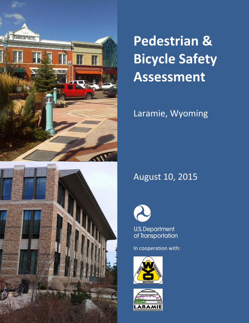
Pedestrian & Bicycle Safety Assessment Laramie, Wyoming August 10, 2015 In cooperation with:
Transcript of Pedestrian & Bicycle Safety Assessment...Laramie Pedestrian & Bicycle Safety Assessment U.S....
Pedestrian & Bicycle Safety Assessment
Laramie, Wyoming
August 10, 2015
In cooperation with:


Laramie Pedestrian & Bicycle Safety Assessment
U.S. Department of Transportation i
Table of Contents Table of Contents ................................................................................................................. i
Executive Summary ............................................................................................................ iii
Introduction ........................................................................................................................ 1
Safer People, Safer Streets.............................................................................................. 1
USDOT Action Plan .......................................................................................................... 2
Walking and Bicycling Safety Assessments ..................................................................... 2
Partners ........................................................................................................................... 3
Assessment Location ........................................................................................................... 4
Transportation Infrastructure ............................................................................................. 6
Motorized........................................................................................................................ 6
Transit ........................................................................................................................... 11
Pedestrian ..................................................................................................................... 12
Bicycle ........................................................................................................................... 16
Crash Trends and Risk Factors .......................................................................................... 19
Community Pedestrian & Bicycle Planning ....................................................................... 23
Comprehensive Plan ..................................................................................................... 23
Bicycle and Trails Master Plan ...................................................................................... 23
Downtown Development Plan ...................................................................................... 26
Framework for Moving Forward ....................................................................................... 29
Multimodal Level of Service/Quality of Service ............................................................ 29
Pedestrian Environment ............................................................................................... 33
Downtown ..................................................................................................................... 39
Bicycle Network ............................................................................................................ 42
Transit Enhancements .................................................................................................. 48
Access Management ..................................................................................................... 49
Design Guidelines .......................................................................................................... 50
Accessibility ................................................................................................................... 51
Complete Streets .......................................................................................................... 52
Transportation Management ........................................................................................ 52
Laramie Pedestrian & Bicycle Safety Assessment
U.S. Department of Transportation ii
Laramie Pedestrian & Bicycle Safety Assessment
U.S. Department of Transportation iii
Executive Summary As part of the U.S. Department of Transportation Action Plan to increase walking, and biking and reduce pedestrian, and bicyclist fatalities, the Wyoming Division of the Federal Highway Administration (FHWA) conducted a Pedestrian and Bicycle Safety Assessment in the city of Laramie. The Assessment was conducted in partnership with the Wyoming Department of Transportation (WYDOT) and the city of Laramie. The study area was centered along US-30/ Grand Avenue between the downtown and University of Wyoming. Ivinson Avenue and Garfield Street were also included.
There is good cohesion in Laramie’s street network with a continuous, well-connected grid of streets. There are continuous sidewalks along both sides of all streets and sidewalks are buffered from traffic with a grass/tree area between the sidewalk and the roadway curb. Combined with transit and bicycle facilities, the network enables a range of alternative transportation options, modes and routes.
With the University of Wyoming and proximity to the downtown, the area provides high density/mixed land uses with a variety of destinations within a compact area. The good street connectivity combined with a diverse mixture of land uses and jobs-housing balance enhance the pedestrian and bicycle-friendliness of an area.
Observations during the assessment included:
• Sidewalk conditions are variable with some areas in need of maintenance. • Tree roots have caused heaving and tilting of sidewalk sections. • Visibility of crosswalk markings are in need of improvement. • Many intersections do not have ADA-compliant ramps. • Pavement surface improvements, bicycle-compatible drainage grates, and street
maintenance are needed to support bicycle safety. • Bike lanes on Ivinson Avenue should provide a better link into the downtown. • Bikes are permitted on US-30/ Grand Avenue; however, narrow lanes and higher
volumes make this route less desirable than other parallel streets. • Lower traffic volumes and wide shared traffic lanes on Garfield Street allow this
street to function well as a bike route. • There are not dedicated bike lanes in the downtown, but low traffic speeds make
this area conducive to bicycle travel in general purpose lanes. • The downtown has pull-in/angle parking, which can create concerns for cars backing
into cyclists.
The City and WYDOT should continue to work together towards systematic multimodal transportation management. Below are some best practices to consider:
• Transportation system performance should utilize a multimodal approach to evaluating transportation strategies for meeting the community’s mobility needs.
• The City should establish a sidewalk maintenance program that shares costs with adjoining property owners, supplements with funding from other sources and maximizes cost efficiencies of sidewalk maintenance costs.
Laramie Pedestrian & Bicycle Safety Assessment
U.S. Department of Transportation iv
• Improvements for curb ramps, crosswalk markings, pedestrian signals, pedestrian warning signs and crosswalk lighting should be evaluated.
• The downtown streets could incorporate curb extensions (bulb-outs) and raised pedestrian crossings at key locations.
• Back-in/head-out angle parking could be considered in the downtown an alternative for bicycle and pedestrian safety.
• Reconstruction of Ivinson Avenue will be an opportunity to focus on creating high bicycle quality and level of service (LOS) corridor with separated bike lanes.
• Garfield Street provides a continuous route from the east end of the City to the downtown and can serve as a bike route with shared lanes or bike lanes.
• Transit stops should have appropriate landings, shelters, lighting, and signage. • Maintenance of pedestrian facilities and ADA upgrades should be prioritized for
areas surrounding transit stops. • Access management should be considered along blocks with multiple access points
to minimize conflicting movements of vehicles with pedestrians and bicyclists. • The City’s zoning and subdivision codes should be reviewed to ensure that new
development incorporates pedestrian and bicycle-friendly design principals. • The City is required to have an ADA Transition Plan that identifies physical obstacles
to accessibility along City streets and plan to make facilities accessible. • The City could consider some form of Complete Streets policy to institutionalize
goals for creating a multimodal transportation system. • Land use planning and neighborhood design standards should be used in
conjunction with transportation system management to accommodate employment and population growth while managing growth in traffic.
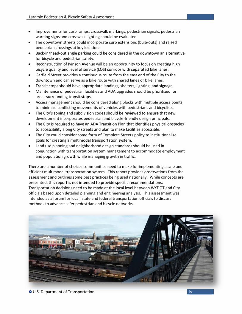
There are a number of choices communities need to make for implementing a safe and efficient multimodal transportation system. This report provides observations from the assessment and outlines some best practices being used nationally. While concepts are presented, this report is not intended to provide specific recommendations. Transportation decisions need to be made at the local level between WYDOT and City officials based upon detailed planning and engineering analysis. This assessment was intended as a forum for local, state and federal transportation officials to discuss methods to advance safer pedestrian and bicycle networks.
Laramie Pedestrian & Bicycle Safety Assessment
U.S. Department of Transportation 1
Introduction Safer People, Safer Streets In September 2014, U.S. Department of Transportation Secretary Anthony R. Foxx released an Action Plan to increase walking, and biking and reduce pedestrian, and bicyclist fatalities.
Around the country, States and cities are documenting increasing numbers of people walking and bicycling for their commutes, errands, recreation, and other travel. For some people, walking and bicycling are the only transportation options. This boom in non-motorized travel has been supported by infrastructure and design improvements that encourage safe walking and bicycling, increased use of public transportation, as well as the development of urban bike-sharing programs. Americans have demonstrated that when we have greater access to safe infrastructure for walking or bicycling, we are eager to enjoy the health benefits, cost savings, and pleasure of walking or riding through our communities.
Secretary Foxx and the U.S. Department of Transportation strongly support this increase in use of these environmentally-friendly transportation options which help reduce congestion and general wear and tear on roadways. Non-motorized infrastructure and bike-share systems are critical to increasing access and connectivity to existing and planned bus and passenger rail systems, linking our transportation systems together into a multimodal network.
With the increase in biking and walking, the potential for conflict between motorized and non-motorized travelers has also increased. Since 2009, fatalities have been increasing for bicyclists and pedestrians. In 2012, bicyclist and pedestrian fatalities were over 16% of all traffic-related fatalities.
Secretary Foxx has declared pedestrian and bicyclist safety as a top priority for the DOT. The Department’s pedestrian and bicyclist safety initiative focuses many departmental resources on the problem and helping to improve the safety of the growing number of Americans traveling by bike or by foot to reach transit or other important destinations including work, job training, school, healthcare and community services.
Safer People, Safer Streets: Summary of U.S. Department of Transportation Action Plan to Increase Walking and Biking and Reduce Pedestrian and Bicyclist Fatalities, September 2014
Laramie Pedestrian & Bicycle Safety Assessment
U.S. Department of Transportation 2
USDOT Action Plan As part of our safety goals, the USDOT Action Plan seeks to increase the rates of walking and bicycling while also reducing fatalities and injuries for both pedestrians and bicyclists. The activities will include engineering designs for safer roadways and pedestrian/bicyclist accessibility; encouragement of walking and bicycling; education for drivers, pedestrians, and bicyclists to promote safe road-sharing; enforcement of traffic laws to protect the safety of all roadway users; and exploration of emerging technologies that can protect pedestrians and bicyclists from motor vehicles.
The Secretary of Transportation is committed to reversing the recent increase in non-motorized fatalities, and injuries and has launched a multi-pronged Pedestrian and Bicycle Safety Initiative. This coordinated approach includes three complementary strategies:
• Safer Streets Strategy • Safer Communities Strategy • Safer Policies Strategyi
Walking and Bicycling Safety Assessments As part of the Safer Streets Strategy, Federal Highway Administration (FHWA), Federal Transit Administration (FTA), and National Highway and Traffic Safety Administration (NHTSA) field offices in each state conducted walking and bicycling safety assessments. These assessments provided an opportunity to bring together interested stakeholders with Federal, State, and local transportation planners and engineers to discuss ways to improve non-motorized safety and transportation efficiency.
The primary focus of the assessment was safety and accessibility. This provided an opportunity to look at examples of safety issues and make suggestions on measures and facilities that can be considered on a community-wide basis to improve safety. This report summarizes the observations and provides suggestions to enable the community to improve pedestrian and bicycle safety while creating a safer and more comfortable environment that can enhance the community’s quality of life.
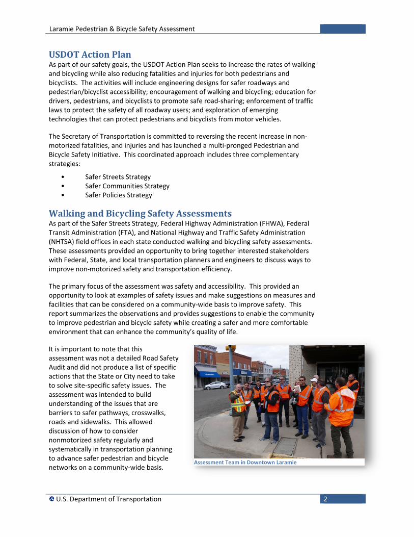
It is important to note that this assessment was not a detailed Road Safety Audit and did not produce a list of specific actions that the State or City need to take to solve site-specific safety issues. The assessment was intended to build understanding of the issues that are barriers to safer pathways, crosswalks, roads and sidewalks. This allowed discussion of how to consider nonmotorized safety regularly and systematically in transportation planning to advance safer pedestrian and bicycle networks on a community-wide basis.
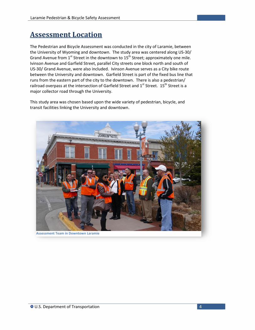
Assessment Team in Downtown Laramie
Laramie Pedestrian & Bicycle Safety Assessment
U.S. Department of Transportation 3
Partners The purpose of these assessments is to facilitate and encourage relationship-building between people who work for the different jurisdictions that share responsibility for creating safer streets. Participants in the assessment included members from U.S. DOT, State DOT, local agencies, and community groups, including the following:
U.S. Department of Transportation
Wyoming Department of Transportation
City of Laramie
Albany County
University of Wyoming
Laramie Main street Alliance
Laramie Plains Civic Center
Laramie BikeNet
Wyoming Pathways
Laramie Pedestrian & Bicycle Safety Assessment
U.S. Department of Transportation 4
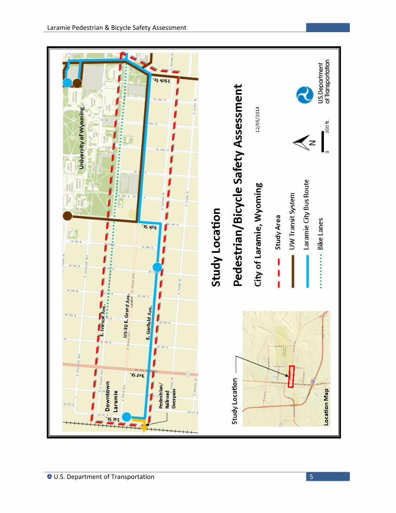
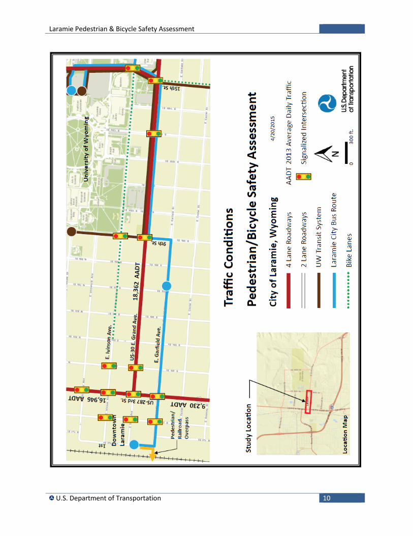
Assessment Location The Pedestrian and Bicycle Assessment was conducted in the city of Laramie, between the University of Wyoming and downtown. The study area was centered along US-30/ Grand Avenue from 1st Street in the downtown to 15th Street; approximately one mile. Ivinson Avenue and Garfield Street, parallel City streets one block north and south of US-30/ Grand Avenue, were also included. Ivinson Avenue serves as a City bike route between the University and downtown. Garfield Street is part of the fixed bus line that runs from the eastern part of the city to the downtown. There is also a pedestrian/ railroad overpass at the intersection of Garfield Street and 1st Street. 15th Street is a major collector road through the University.
This study area was chosen based upon the wide variety of pedestrian, bicycle, and transit facilities linking the University and downtown.
Assessment Team in Downtown Laramie
Laramie Pedestrian & Bicycle Safety Assessment
U.S. Department of Transportation 5
Laramie Pedestrian & Bicycle Safety Assessment
U.S. Department of Transportation 6
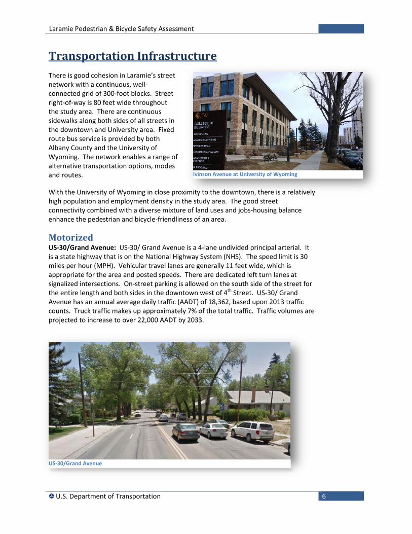
Transportation Infrastructure There is good cohesion in Laramie’s street network with a continuous, well-connected grid of 300-foot blocks. Street right-of-way is 80 feet wide throughout the study area. There are continuous sidewalks along both sides of all streets in the downtown and University area. Fixed route bus service is provided by both Albany County and the University of Wyoming. The network enables a range of alternative transportation options, modes and routes.
With the University of Wyoming in close proximity to the downtown, there is a relatively high population and employment density in the study area. The good street connectivity combined with a diverse mixture of land uses and jobs-housing balance enhance the pedestrian and bicycle-friendliness of an area.
Motorized US-30/Grand Avenue: US-30/ Grand Avenue is a 4-lane undivided principal arterial. It is a state highway that is on the National Highway System (NHS). The speed limit is 30 miles per hour (MPH). Vehicular travel lanes are generally 11 feet wide, which is appropriate for the area and posted speeds. There are dedicated left turn lanes at signalized intersections. On-street parking is allowed on the south side of the street for the entire length and both sides in the downtown west of 4th Street. US-30/ Grand Avenue has an annual average daily traffic (AADT) of 18,362, based upon 2013 traffic counts. Truck traffic makes up approximately 7% of the total traffic. Traffic volumes are projected to increase to over 22,000 AADT by 2033.ii
Ivinson Avenue at University of Wyoming
US-30/Grand Avenue
Laramie Pedestrian & Bicycle Safety Assessment
U.S. Department of Transportation 7
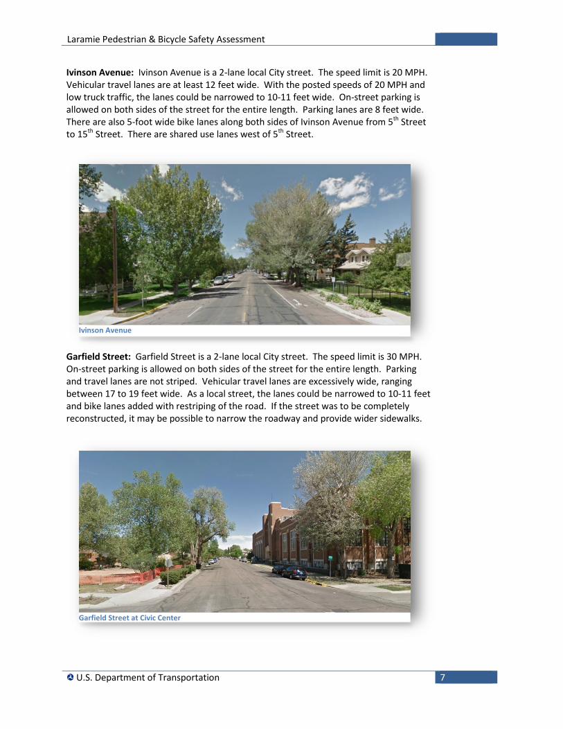
Ivinson Avenue: Ivinson Avenue is a 2-lane local City street. The speed limit is 20 MPH. Vehicular travel lanes are at least 12 feet wide. With the posted speeds of 20 MPH and low truck traffic, the lanes could be narrowed to 10-11 feet wide. On-street parking is allowed on both sides of the street for the entire length. Parking lanes are 8 feet wide. There are also 5-foot wide bike lanes along both sides of Ivinson Avenue from 5th Street to 15th Street. There are shared use lanes west of 5th Street.
Garfield Street: Garfield Street is a 2-lane local City street. The speed limit is 30 MPH. On-street parking is allowed on both sides of the street for the entire length. Parking and travel lanes are not striped. Vehicular travel lanes are excessively wide, ranging between 17 to 19 feet wide. As a local street, the lanes could be narrowed to 10-11 feet and bike lanes added with restriping of the road. If the street was to be completely reconstructed, it may be possible to narrow the roadway and provide wider sidewalks.
Ivinson Avenue
Garfield Street at Civic Center
Laramie Pedestrian & Bicycle Safety Assessment
U.S. Department of Transportation 8
Intersections: Intersections in the study area typically don’t have excessively wide curb radii that would encourage high-speed right turns. Signalized intersections generally provide left turn lanes, but most do not provided right–turn only lanes.
Grand Avenue and 3rd Intersection: The intersection of US-30/ Grand Avenue and US-287/3rd Street has a large number of turning movements, including a significant number of truck turning movements. There are also a large number of pedestrians that cross against the signal at the intersection of US-30/ Grand Avenue and US-287/3rd Street. Pedestrians tend to cross when they see the green ball for parallel vehicular traffic, but fail to observe the DON’T WALK pedestrian indication when there are protected left turns.
Grand Avenue and 9th Street Intersection: The intersection of US-30/ Grand Avenue and 9th Street has a large number of pedestrian conflicts with left turning vehicles. There are a high number of pedestrians crossing US-30/ Grand Avenue on the east side of 9th Street walking to and from the University. This is also the intersection with the highest pedestrian crash rate in the study area, as detailed later in the Crash Trends and Risk Factors section.
Grand Avenue and 15th Intersection: There is one channelized right turn lane at the intersection of US-30/ Grand Avenue and 15th Street. The crossing location for the channelized right turn lane is at the midpoint of the island. Channelized right turn lanes can enhance pedestrian safety by allowing pedestrians to cross the right-turn lane separately, using the channelizing island for refuge. However, if the channelized right turn lane is designed with a large radius to favor the movement of vehicular traffic and facilitate high-speed turns, traffic may not yield to pedestrians.
Ivinson Avenue and 15th Intersection: The intersection of Ivinson Avenue and 15th Street has the highest pedestrian traffic. Concerns regarding vehicle right turn movements from 15th Street onto Ivinson Avenue, and the predictability of pedestrian and bicycle traffic at the intersection were discussed. Furthermore, concerns were raised regarding vehicles conducting a right turn movement to 15th Street southbound by crossing into the bicycle lane and mounting the curb to position the vehicle for right turn movement.
At Ivinson Avenue and 15th Street, one of the pedestrian phases (from the residence halls to the northwest corner of the intersection) currently operates as a pseudo-scramble. All vehicle movements are given a red ball with a pedestrian movement permitted for the southeast to the northwest of the intersection. All other pedestrian movements (one north-south crossing Ivinson, one east-west crossing 15th) remain non-permitted.
Ivinson Avenue and 3rd Intersection: The intersection of Ivinson and US-287/3rd Street has a Leading pedestrian interval (LPI). The LPI releases pedestrians 3 seconds prior to the green light for vehicles so pedestrians can enter and occupy the crosswalk before turning drivers begin to move. By giving pedestrians a head start, it is less likely that there will be conflict between pedestrians and turning vehicles.
Laramie Pedestrian & Bicycle Safety Assessment
U.S. Department of Transportation 9
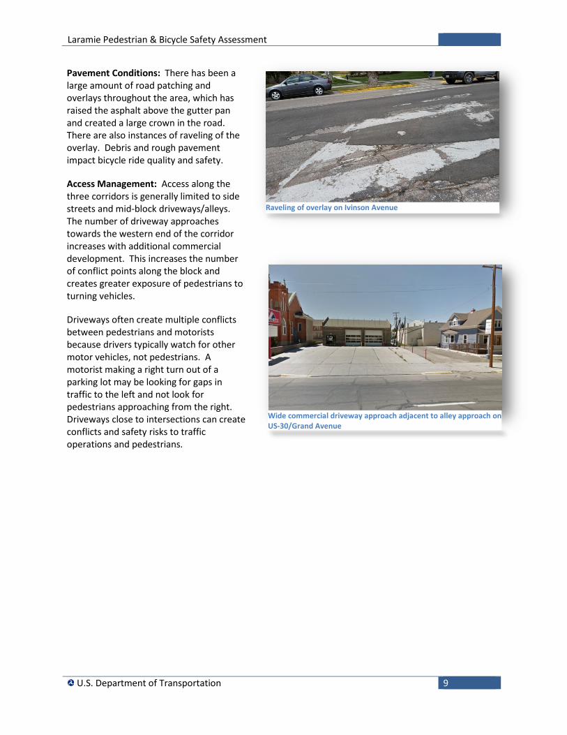
Pavement Conditions: There has been a large amount of road patching and overlays throughout the area, which has raised the asphalt above the gutter pan and created a large crown in the road. There are also instances of raveling of the overlay. Debris and rough pavement impact bicycle ride quality and safety.
Access Management: Access along the three corridors is generally limited to side streets and mid-block driveways/alleys. The number of driveway approaches towards the western end of the corridor increases with additional commercial development. This increases the number of conflict points along the block and creates greater exposure of pedestrians to turning vehicles.
Driveways often create multiple conflicts between pedestrians and motorists because drivers typically watch for other motor vehicles, not pedestrians. A motorist making a right turn out of a parking lot may be looking for gaps in traffic to the left and not look for pedestrians approaching from the right. Driveways close to intersections can create conflicts and safety risks to traffic operations and pedestrians.
Raveling of overlay on Ivinson Avenue
Wide commercial driveway approach adjacent to alley approach on US-30/Grand Avenue
Laramie Pedestrian & Bicycle Safety Assessment
U.S. Department of Transportation 10
Laramie Pedestrian & Bicycle Safety Assessment
U.S. Department of Transportation 11
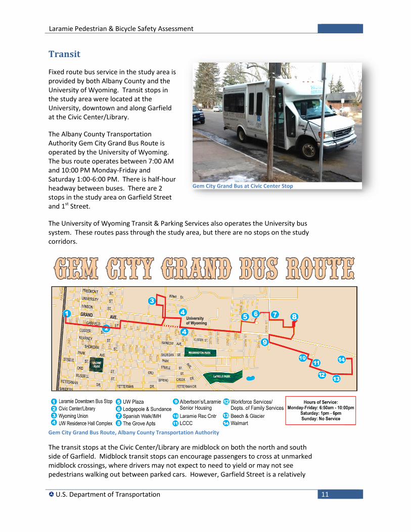
Transit
Fixed route bus service in the study area is provided by both Albany County and the University of Wyoming. Transit stops in the study area were located at the University, downtown and along Garfield at the Civic Center/Library.
The Albany County Transportation Authority Gem City Grand Bus Route is operated by the University of Wyoming. The bus route operates between 7:00 AM and 10:00 PM Monday-Friday and Saturday 1:00-6:00 PM. There is half-hour headway between buses. There are 2 stops in the study area on Garfield Street and 1st Street.
The University of Wyoming Transit & Parking Services also operates the University bus system. These routes pass through the study area, but there are no stops on the study corridors.
Gem City Grand Bus Route, Albany County Transportation Authority
The transit stops at the Civic Center/Library are midblock on both the north and south side of Garfield. Midblock transit stops can encourage passengers to cross at unmarked midblock crossings, where drivers may not expect to need to yield or may not see pedestrians walking out between parked cars. However, Garfield Street is a relatively
Gem City Grand Bus at Civic Center Stop
Laramie Pedestrian & Bicycle Safety Assessment
U.S. Department of Transportation 12
low volume road. The bus stop signs on Garfield Street only face one direction and are not visible by pedestrians approaching from the other directions. The bus stops on Garfield are not well-lit.
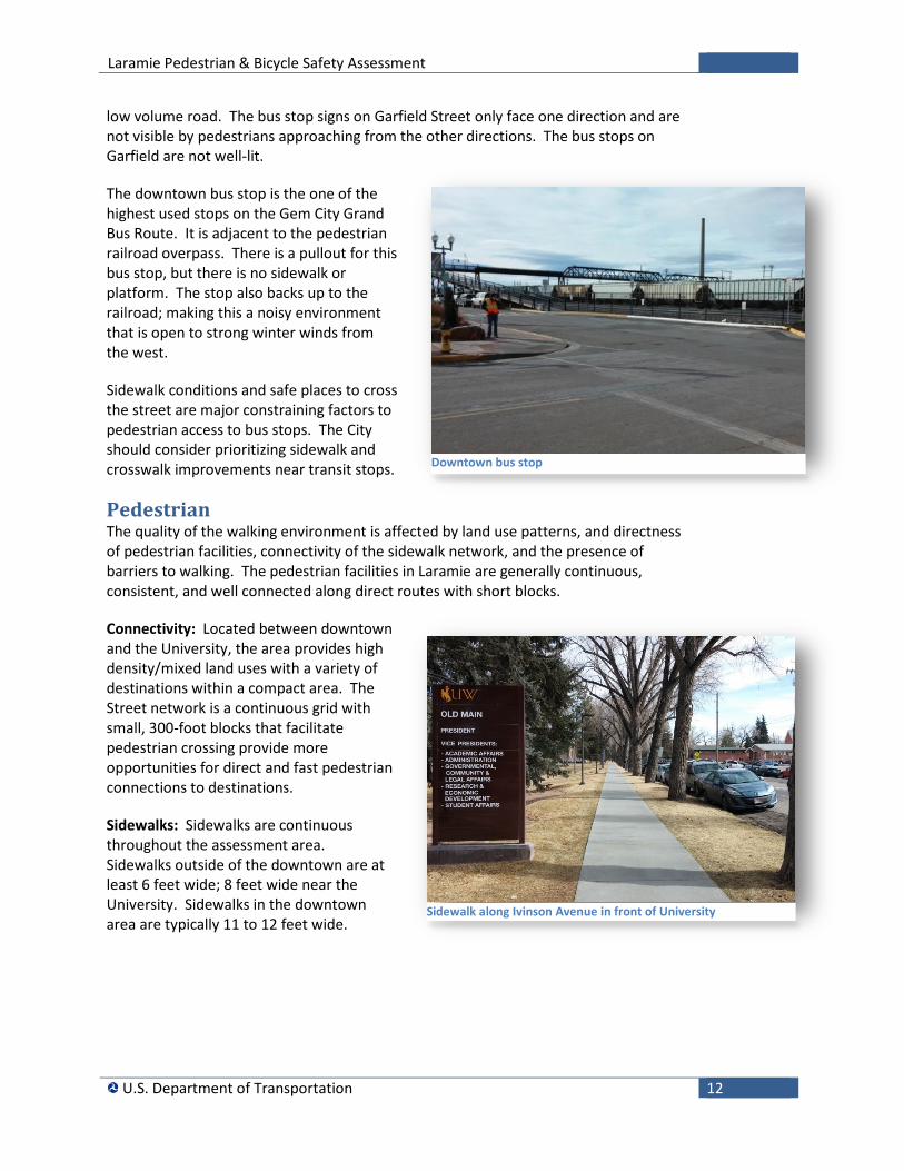
The downtown bus stop is the one of the highest used stops on the Gem City Grand Bus Route. It is adjacent to the pedestrian railroad overpass. There is a pullout for this bus stop, but there is no sidewalk or platform. The stop also backs up to the railroad; making this a noisy environment that is open to strong winter winds from the west.
Sidewalk conditions and safe places to cross the street are major constraining factors to pedestrian access to bus stops. The City should consider prioritizing sidewalk and crosswalk improvements near transit stops.
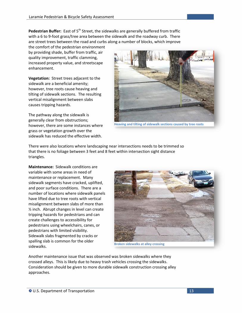
Pedestrian The quality of the walking environment is affected by land use patterns, and directness of pedestrian facilities, connectivity of the sidewalk network, and the presence of barriers to walking. The pedestrian facilities in Laramie are generally continuous, consistent, and well connected along direct routes with short blocks.
Connectivity: Located between downtown and the University, the area provides high density/mixed land uses with a variety of destinations within a compact area. The Street network is a continuous grid with small, 300-foot blocks that facilitate pedestrian crossing provide more opportunities for direct and fast pedestrian connections to destinations.
Sidewalks: Sidewalks are continuous throughout the assessment area. Sidewalks outside of the downtown are at least 6 feet wide; 8 feet wide near the University. Sidewalks in the downtown area are typically 11 to 12 feet wide.
Downtown bus stop
Sidewalk along Ivinson Avenue in front of University
Laramie Pedestrian & Bicycle Safety Assessment
U.S. Department of Transportation 13
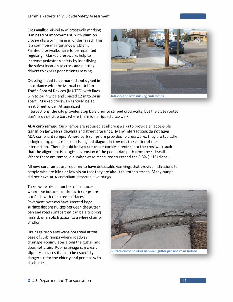
Pedestrian Buffer: East of 5th Street, the sidewalks are generally buffered from traffic with a 6 to 9-foot grass/tree area between the sidewalk and the roadway curb. There are street trees between the road and curbs along a number of blocks, which improve the comfort of the pedestrian environment by providing shade, buffer from traffic, air quality improvement, traffic clamming, increased property value, and streetscape enhancement.
Vegetation: Street trees adjacent to the sidewalk are a beneficial amenity; however, tree roots cause heaving and tilting of sidewalk sections. The resulting vertical misalignment between slabs causes tripping hazards.
The pathway along the sidewalk is generally clear from obstructions; however, there are some instances where grass or vegetation growth over the sidewalk has reduced the effective width.
There were also locations where landscaping near intersections needs to be trimmed so that there is no foliage between 3 feet and 8 feet within intersection sight distance triangles.
Maintenance: Sidewalk conditions are variable with some areas in need of maintenance or replacement. Many sidewalk segments have cracked, uplifted, and poor surface conditions. There are a number of locations where sidewalk panels have lifted due to tree roots with vertical misalignment between slabs of more than ½ inch. Abrupt changes in level can create tripping hazards for pedestrians and can create challenges to accessibility for pedestrians using wheelchairs, canes, or pedestrians with limited visibility. Sidewalk slabs fragmented by cracks or spalling slab is common for the older sidewalks.
Another maintenance issue that was observed was broken sidewalks where they crossed alleys. This is likely due to heavy trash vehicles crossing the sidewalks. Consideration should be given to more durable sidewalk construction crossing alley approaches.
Heaving and tilting of sidewalk sections caused by tree roots
Broken sidewalks at alley crossing
Laramie Pedestrian & Bicycle Safety Assessment
U.S. Department of Transportation 14
Crosswalks: Visibility of crosswalk marking is in need of improvement, with paint on crosswalks worn, missing, or damaged. This is a common maintenance problem. Painted crosswalks have to be repainted regularly. Marked crosswalks help to increase pedestrian safety by identifying the safest location to cross and alerting drivers to expect pedestrians crossing.
Crossings need to be marked and signed in accordance with the Manual on Uniform Traffic Control Devices (MUTCD) with lines 6 in to 24 in wide and spaced 12 in to 24 in apart. Marked crosswalks should be at least 6 feet wide. At signalized intersections, the city provides stop bars prior to striped crosswalks, but the state routes don’t provide stop bars where there is a stripped crosswalk.
ADA curb ramps: Curb ramps are required at all crosswalks to provide an accessible transition between sidewalks and street crossings. Many intersections do not have ADA-compliant ramps. Where curb ramps are provided to crosswalks, they are typically a single ramp per corner that is aligned diagonally towards the center of the intersection. There should be two ramps per corner directed into the crosswalk such that the alignment is a logical extension of the pedestrian path from the sidewalk. Where there are ramps, a number were measured to exceed the 8.3% (1:12) slope.
All new curb ramps are required to have detectable warnings that provide indications to people who are blind or low vision that they are about to enter a street. Many ramps did not have ADA-compliant detectable warnings.
There were also a number of instances where the bottoms of the curb ramps are not flush with the street surfaces. Pavement overlays have created large surface discontinuities between the gutter pan and road surface that can be a tripping hazard, or an obstruction to a wheelchair or stroller.
Drainage problems were observed at the base of curb ramps where roadway drainage accumulates along the gutter and does not drain. Poor drainage can create slippery surfaces that can be especially dangerous for the elderly and persons with disabilities.
Intersection with missing curb ramps
Surface discontinuities between gutter pan and road surface
Laramie Pedestrian & Bicycle Safety Assessment
U.S. Department of Transportation 15
There were also examples where the sidewalk cross slope towards the street exceeded 2%. This was particularly a problem where driveways crossed the sidewalk.
During the study area walk, some concerns were raised by the participants regarding sight distance at the stop-controlled intersections, particularly along Ivinson Street.
Pedestrian signals: Most signalized intersections had pedestrian signals and pedestrian actuated push buttons. Most crossing times met the MUTCD standard for walking speed 3.5 feet per second. Countdown signals were only provided at the crosswalks adjacent to the University. Most intersections in the downtown do not have pedestrian signals, which the City has noted as a needed upgrade.
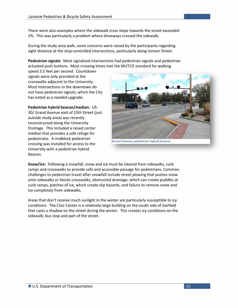
Pedestrian hybrid beacon/median: US-30/ Grand Avenue east of 15th Street (just outside study area) was recently reconstructed along the University frontage. This included a raised center median that provides a safe refuge for pedestrians. A midblock pedestrian crossing was installed for access to the University with a pedestrian hybrid beacon.
Snow/ice: Following a snowfall, snow and ice must be cleared from sidewalks, curb ramps and crosswalks to provide safe and accessible passage for pedestrians. Common challenges to pedestrian travel after snowfall include street plowing that pushes snow onto sidewalks or blocks crosswalks, obstructed drainage, which can create puddles at curb ramps, patches of ice, which create slip hazards, and failure to remove snow and ice completely from sidewalks.
Areas that don’t receive much sunlight in the winter are particularly susceptible to icy conditions. The Civic Center is a relatively large building on the south side of Garfield that casts a shadow on the street during the winter. This creates icy conditions on the sidewalk, bus stop and part of the street.
Grand Avenue pedestrian hybrid beacon
Laramie Pedestrian & Bicycle Safety Assessment
U.S. Department of Transportation 16
Bicycle Laramie ranked 8th nationally among small cities for rates of bicycling to work. According to the U.S. Census Bureau, 6.8% of the population bicycle to work.iii The cycling network with the grid street pattern provides continuous and convenient linkages to destinations.
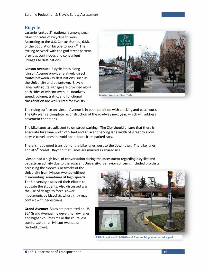
Ivinson Avenue: Bicycle lanes along Ivinson Avenue provide relatively direct routes between key destinations, such as the University and downtown. Bicycle lanes with route signage are provided along both sides of Ivinson Avenue. Roadway speed, volume, traffic, and functional classification are well-suited for cyclists.
The riding surface on Ivinson Avenue is in poor condition with cracking and patchwork. The City plans a complete reconstruction of the roadway next year, which will address pavement conditions.
The bike lanes are adjacent to on-street parking. The City should ensure that there is adequate bike lane width of 5 feet and adjacent parking lane width of 9 feet to allow bicycle travel lanes to avoid open doors from parked cars.
There is not a good transition of the bike lanes west to the downtown. The bike lanes end at 5th Street. Beyond that, lanes are marked as shared use.
Ivinson had a high level of conversation during the assessment regarding bicyclist and pedestrian activity due to the adjacent University. Behavior concerns included bicyclists accessing the sidewalk networks of the University from Ivinson Avenue without dismounting, sometimes at high speeds. The University discussed their efforts to educate the students. Also discussed was the use of design to force slower movements by bicyclists where they may conflict with pedestrians.
Grand Avenue: Bikes are permitted on US-30/ Grand Avenue; however, narrow lanes and higher volumes make this route less comfortable than Ivinson Avenue or Garfield Street.
Ivinson Avenue bike route
13th Street and US-30/Grand Avenue bicycle actuated signal
Laramie Pedestrian & Bicycle Safety Assessment
U.S. Department of Transportation 17
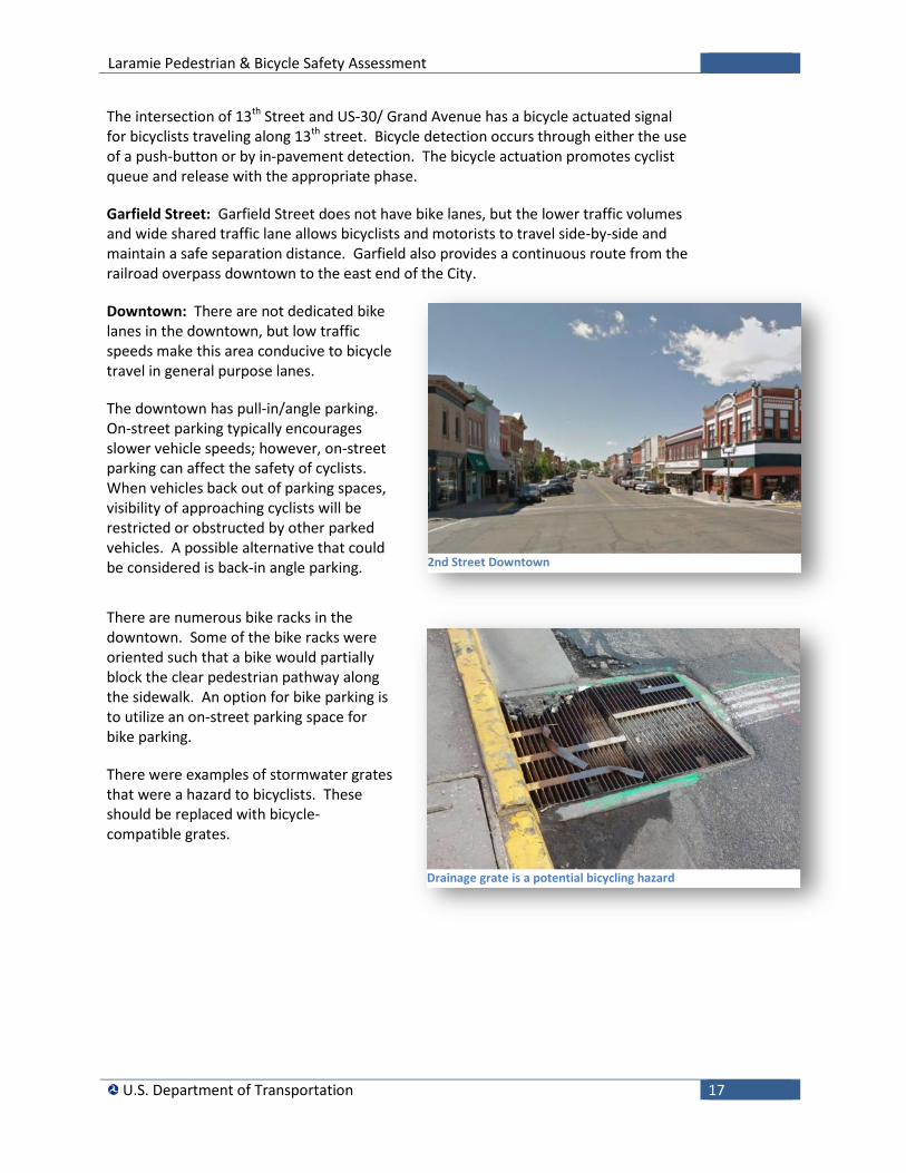
The intersection of 13th Street and US-30/ Grand Avenue has a bicycle actuated signal for bicyclists traveling along 13th street. Bicycle detection occurs through either the use of a push-button or by in-pavement detection. The bicycle actuation promotes cyclist queue and release with the appropriate phase.
Garfield Street: Garfield Street does not have bike lanes, but the lower traffic volumes and wide shared traffic lane allows bicyclists and motorists to travel side-by-side and maintain a safe separation distance. Garfield also provides a continuous route from the railroad overpass downtown to the east end of the City.
Downtown: There are not dedicated bike lanes in the downtown, but low traffic speeds make this area conducive to bicycle travel in general purpose lanes.
The downtown has pull-in/angle parking. On-street parking typically encourages slower vehicle speeds; however, on-street parking can affect the safety of cyclists. When vehicles back out of parking spaces, visibility of approaching cyclists will be restricted or obstructed by other parked vehicles. A possible alternative that could be considered is back-in angle parking.
There are numerous bike racks in the downtown. Some of the bike racks were oriented such that a bike would partially block the clear pedestrian pathway along the sidewalk. An option for bike parking is to utilize an on-street parking space for bike parking.
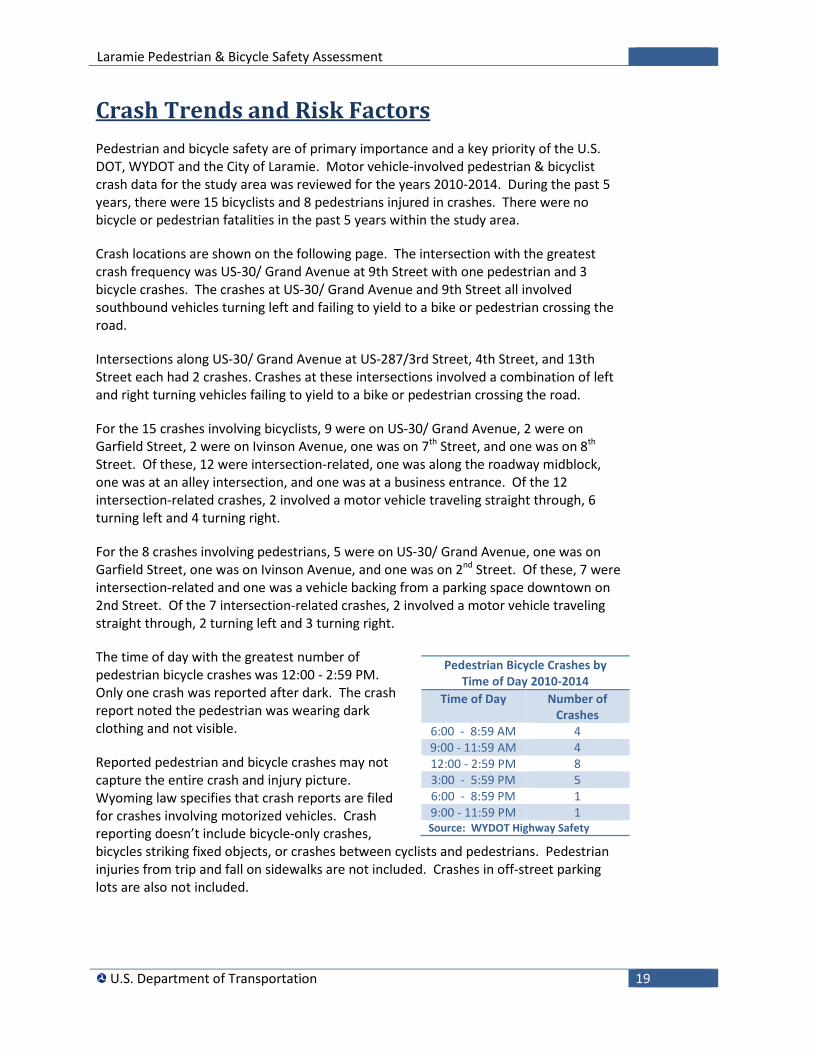
There were examples of stormwater grates that were a hazard to bicyclists. These should be replaced with bicycle-compatible grates.
2nd Street Downtown
Drainage grate is a potential bicycling hazard

Laramie Pedestrian & Bicycle Safety Assessment
U.S. Department of Transportation 18
Laramie Pedestrian & Bicycle Safety Assessment
U.S. Department of Transportation 19
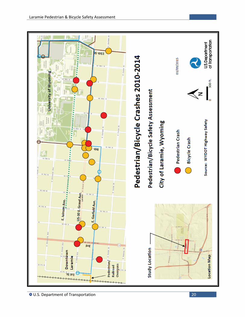
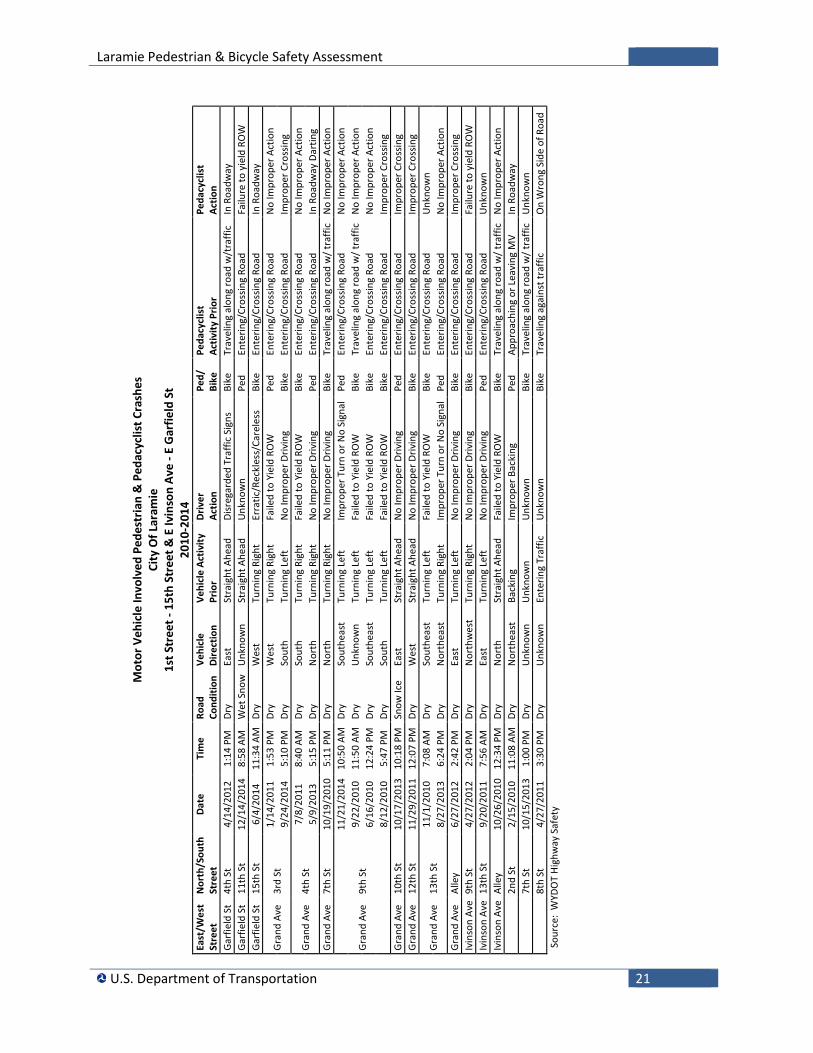
Crash Trends and Risk Factors Pedestrian and bicycle safety are of primary importance and a key priority of the U.S. DOT, WYDOT and the City of Laramie. Motor vehicle-involved pedestrian & bicyclist crash data for the study area was reviewed for the years 2010-2014. During the past 5 years, there were 15 bicyclists and 8 pedestrians injured in crashes. There were no bicycle or pedestrian fatalities in the past 5 years within the study area.
Crash locations are shown on the following page. The intersection with the greatest crash frequency was US-30/ Grand Avenue at 9th Street with one pedestrian and 3 bicycle crashes. The crashes at US-30/ Grand Avenue and 9th Street all involved southbound vehicles turning left and failing to yield to a bike or pedestrian crossing the road.
Intersections along US-30/ Grand Avenue at US-287/3rd Street, 4th Street, and 13th Street each had 2 crashes. Crashes at these intersections involved a combination of left and right turning vehicles failing to yield to a bike or pedestrian crossing the road.
For the 15 crashes involving bicyclists, 9 were on US-30/ Grand Avenue, 2 were on Garfield Street, 2 were on Ivinson Avenue, one was on 7th Street, and one was on 8th Street. Of these, 12 were intersection-related, one was along the roadway midblock, one was at an alley intersection, and one was at a business entrance. Of the 12 intersection-related crashes, 2 involved a motor vehicle traveling straight through, 6 turning left and 4 turning right.
For the 8 crashes involving pedestrians, 5 were on US-30/ Grand Avenue, one was on Garfield Street, one was on Ivinson Avenue, and one was on 2nd Street. Of these, 7 were intersection-related and one was a vehicle backing from a parking space downtown on 2nd Street. Of the 7 intersection-related crashes, 2 involved a motor vehicle traveling straight through, 2 turning left and 3 turning right.
The time of day with the greatest number of pedestrian bicycle crashes was 12:00 - 2:59 PM. Only one crash was reported after dark. The crash report noted the pedestrian was wearing dark clothing and not visible.
Reported pedestrian and bicycle crashes may not capture the entire crash and injury picture. Wyoming law specifies that crash reports are filed for crashes involving motorized vehicles. Crash reporting doesn’t include bicycle-only crashes, bicycles striking fixed objects, or crashes between cyclists and pedestrians. Pedestrian injuries from trip and fall on sidewalks are not included. Crashes in off-street parking lots are also not included.
Pedestrian Bicycle Crashes by Time of Day 2010-2014
Time of Day Number of Crashes
6:00 - 8:59 AM 4 9:00 - 11:59 AM 4 12:00 - 2:59 PM 8 3:00 - 5:59 PM 5 6:00 - 8:59 PM 1 9:00 - 11:59 PM 1 Source: WYDOT Highway Safety
Laramie Pedestrian & Bicycle Safety Assessment
U.S. Department of Transportation 20
Laramie Pedestrian & Bicycle Safety Assessment
U.S. Department of Transportation 21
Mot
or V
ehic
le In
volv
ed P
edes
tria
n &
Ped
acyc
list C
rash
es
City
Of L
aram
ie
1st S
tree
t - 1
5th
Stre
et &
E Iv
inso
n Av
e - E
Gar
field
St
2010
-201
4 Ea
st/W
est
Stre
et
Nor
th/S
outh
St
reet
Da
te
Tim
e Ro
ad
Cond
ition
Ve
hicl
e Di
rect
ion
Vehi
cle
Activ
ity
Prio
r Dr
iver
Ac
tion
Ped/
Bi
ke
Peda
cycl
ist
Activ
ity P
rior
Peda
cycl
ist
Actio
n Ga
rfie
ld S
t 4t
h St
4/
14/2
012
1:14
PM
Dr
y Ea
st
Stra
ight
Ahe
ad
Disr
egar
ded
Traf
fic S
igns
Bi
ke
Trav
elin
g al
ong
road
w/t
raffi
c In
Roa
dway
Ga
rfie
ld S
t 11
th S
t 12
/14/
2014
8:
58 A
M
Wet
Sno
w
Unk
now
n St
raig
ht A
head
U
nkno
wn
Ped
Ente
ring/
Cros
sing
Road
Fa
ilure
to y
ield
RO
W
Garf
ield
St
15th
St
6/4/
2014
11
:34
AM
Dry
Wes
t Tu
rnin
g Ri
ght
Erra
tic/R
eckl
ess/
Care
less
Bi
ke
Ente
ring/
Cros
sing
Road
In
Roa
dway
Gran
d Av
e 3r
d St
1/
14/2
011
1:53
PM
Dr
y W
est
Turn
ing
Righ
t Fa
iled
to Y
ield
RO
W
Ped
Ente
ring/
Cros
sing
Road
N
o Im
prop
er A
ctio
n 9/
24/2
014
5:10
PM
Dr
y So
uth
Turn
ing
Left
N
o Im
prop
er D
rivin
g Bi
ke
Ente
ring/
Cros
sing
Road
Im
prop
er C
ross
ing
Gran
d Av
e 4t
h St
7/
8/20
11
8:40
AM
Dr
y So
uth
Turn
ing
Righ
t Fa
iled
to Y
ield
RO
W
Bike
En
terin
g/Cr
ossin
g Ro
ad
No
Impr
oper
Act
ion
5/9/
2013
5:
15 P
M
Dry
Nor
th
Turn
ing
Righ
t N
o Im
prop
er D
rivin
g Pe
d En
terin
g/Cr
ossin
g Ro
ad
In R
oadw
ay D
artin
g Gr
and
Ave
7th
St
10/1
9/20
10
5:11
PM
Dr
y N
orth
Tu
rnin
g Ri
ght
No
Impr
oper
Driv
ing
Bike
Tr
avel
ing
alon
g ro
ad w
/ tra
ffic
No
Impr
oper
Act
ion
Gran
d Av
e 9t
h St
11/2
1/20
14
10:5
0 AM
Dr
y So
uthe
ast
Turn
ing
Left
Im
prop
er T
urn
or N
o Si
gnal
Pe
d En
terin
g/Cr
ossin
g Ro
ad
No
Impr
oper
Act
ion
9/22
/201
0 11
:50
AM
Dry
Unk
now
n Tu
rnin
g Le
ft
Faile
d to
Yie
ld R
OW
Bi
ke
Trav
elin
g al
ong
road
w/ t
raffi
c N
o Im
prop
er A
ctio
n 6/
16/2
010
12:2
4 PM
Dr
y So
uthe
ast
Turn
ing
Left
Fa
iled
to Y
ield
RO
W
Bike
En
terin
g/Cr
ossin
g Ro
ad
No
Impr
oper
Act
ion
8/12
/201
0 5:
47 P
M
Dry
Sout
h Tu
rnin
g Le
ft
Faile
d to
Yie
ld R
OW
Bi
ke
Ente
ring/
Cros
sing
Road
Im
prop
er C
ross
ing
Gran
d Av
e 10
th S
t 10
/17/
2013
10
:18
PM
Snow
Ice
East
St
raig
ht A
head
N
o Im
prop
er D
rivin
g Pe
d En
terin
g/Cr
ossin
g Ro
ad
Impr
oper
Cro
ssin
g
Gran
d Av
e 12
th S
t 11
/29/
2011
12
:07
PM
Dry
Wes
t St
raig
ht A
head
N
o Im
prop
er D
rivin
g Bi
ke
Ente
ring/
Cros
sing
Road
Im
prop
er C
ross
ing
Gran
d Av
e 13
th S
t 11
/1/2
010
7:08
AM
Dr
y So
uthe
ast
Turn
ing
Left
Fa
iled
to Y
ield
RO
W
Bike
En
terin
g/Cr
ossin
g Ro
ad
Unk
now
n 8/
27/2
013
6:24
PM
Dr
y N
orth
east
Tu
rnin
g Ri
ght
Impr
oper
Tur
n or
No
Sign
al
Ped
Ente
ring/
Cros
sing
Road
N
o Im
prop
er A
ctio
n Gr
and
Ave
Alle
y 6/
27/2
012
2:42
PM
Dr
y Ea
st
Turn
ing
Left
N
o Im
prop
er D
rivin
g Bi
ke
Ente
ring/
Cros
sing
Road
Im
prop
er C
ross
ing
Ivin
son
Ave
9th
St
4/27
/201
2 2:
04 P
M
Dry
Nor
thw
est
Turn
ing
Righ
t N
o Im
prop
er D
rivin
g Bi
ke
Ente
ring/
Cros
sing
Road
Fa
ilure
to y
ield
RO
W
Ivin
son
Ave
13th
St
9/20
/201
1 7:
56 A
M
Dry
East
Tu
rnin
g Le
ft
No
Impr
oper
Driv
ing
Ped
Ente
ring/
Cros
sing
Road
U
nkno
wn
Ivin
son
Ave
Alle
y 10
/26/
2010
12
:34
PM
Dry
Nor
th
Stra
ight
Ahe
ad
Faile
d to
Yie
ld R
OW
Bi
ke
Trav
elin
g al
ong
road
w/ t
raffi
c N
o Im
prop
er A
ctio
n
2n
d St
2/
15/2
010
11:0
8 AM
Dr
y N
orth
east
Ba
ckin
g Im
prop
er B
acki
ng
Ped
Appr
oach
ing
or L
eavi
ng M
V In
Roa
dway
7t
h St
10
/15/
2013
1:
00 P
M
Dry
Unk
now
n U
nkno
wn
Unk
now
n Bi
ke
Trav
elin
g al
ong
road
w/ t
raffi
c U
nkno
wn
8t
h St
4/
27/2
011
3:30
PM
Dr
y U
nkno
wn
Ente
ring
Traf
fic
Unk
now
n Bi
ke
Trav
elin
g ag
ains
t tra
ffic
On
Wro
ng S
ide
of R
oad
Sour
ce:
WYD
OT
High
way
Saf
ety

Laramie Pedestrian & Bicycle Safety Assessment
U.S. Department of Transportation 22
Laramie Pedestrian & Bicycle Safety Assessment
U.S. Department of Transportation 23
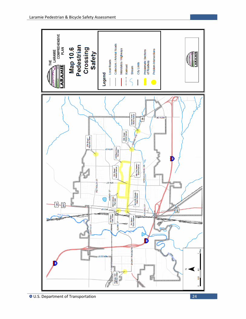
Community Pedestrian & Bicycle Planning Comprehensive Plan The City’s Comprehensive Plan includes a transportation chapter that recommends a multi-modal transportation system, including vehicular, transit, pedestrian, and bicycle.
“A transportation system offers a variety of modes, including both motorized and non-motorized transportation options. Especially in a community with a high student population, the importance of walking and bicycling is heightened. There were comments received through the public input sessions regarding the need for better sidewalks around and adjacent to the University and all around the city, as well as crosswalks and traffic calming improvements to improve pedestrian safety. At the same time, pedestrian improvements such as pedestrian-actuated traffic signals, crosswalk signage, pavement markings, a speed table, curb cuts, boulevards, reduced speeds, handicap ramps, and median breaks are an essential part of the infrastructure necessary to support and encourage pedestrian activity.”iv
The plan acknowledges some of the significant barriers in the sidewalk system, including wide, highly traveled street sections, such as US-287/3rd Street and US-30/ Grand Avenue, needed pedestrian signal upgrades, lack of ADA improvements in the older areas of the City, and sidewalks that are in poor condition.
There are a number of recommendations for non-motorized transportation, including maintaining bike lanes, pedestrian safety improvements, sidewalk maintenance, sidewalk standards for new development and traffic calming. The plan also recommends guidelines for pedestrian access to transit stops.
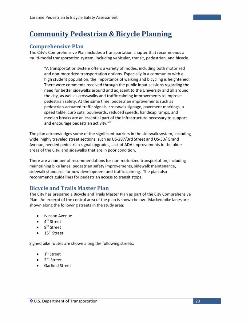
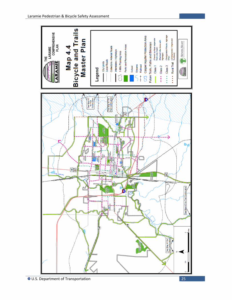
Bicycle and Trails Master Plan The City has prepared a Bicycle and Trails Master Plan as part of the City Comprehensive Plan. An excerpt of the central area of the plan is shown below. Marked bike lanes are shown along the following streets in the study area:
• Ivinson Avenue • 4th Street • 9th Street • 15th Street
Signed bike routes are shown along the following streets:
• 1st Street • 2nd Street • Garfield Street
Laramie Pedestrian & Bicycle Safety Assessment
U.S. Department of Transportation 24
Laramie Pedestrian & Bicycle Safety Assessment
U.S. Department of Transportation 25
Laramie Pedestrian & Bicycle Safety Assessment
U.S. Department of Transportation 26
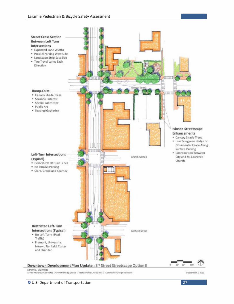
Downtown Development Plan The Downtown Development Plan discusses the importance of linkages between the University and downtown. The Plan states:
“The University of Wyoming/Downtown Connection: While relatively close to each other, the University and downtown still seem to be disconnected. Improvements to the bicycle facilities and the implementation of the new bus as described above will help to improve the connection tremendously. From a street standpoint, stakeholders indicated that the primary streets that should be considered links between the University and downtown include University Avenue, Ivinson and Garfield Streets (primary pedestrian routes) and US-30/ Grand Avenue (primary vehicular route). Consideration should be given to focusing attention on streetscape improvements along these streets, particularly between 3rd and 5th Streets. In particular the south side of Ivinson between 3rd and 5th Streets where there is little shade and the street edge is undefined.” v
The Plan includes a number of recommendations for Ivinson Avenue, US-30/ Grand Avenue and Garfield Street, including streetscape enhancements to improve the quality of the pedestrian environment.
Recommendations are also provided for US-287/3rd Street, which is a State highway. The Plan notes that parking and travel lanes are inadequate and conflicts with left-turning vehicles present hazards for both drivers and pedestrians. The Plan recommends dedicated left turn lanes at some intersections, including US-30/ Grand Avenue. Some parallel parking would need to be eliminated. The recommended option is to maintain parking on the west side of US-287/3rd Street and expanded landscape on the east side, as shown on the following page.
Laramie Pedestrian & Bicycle Safety Assessment
U.S. Department of Transportation 27
Laramie Pedestrian & Bicycle Safety Assessment
U.S. Department of Transportation 28
Laramie Pedestrian & Bicycle Safety Assessment
U.S. Department of Transportation 29
Framework for Moving Forward Pedestrians and bicyclists are legitimate users of the streets and an integral part of the overall transportation system. USDOT statement on bicycle and pedestrian accommodation released in March 2010 articulates this policy. The policy recommends that well-connected pedestrian and bicycle networks should be planned, funded, and implemented, particularly connecting to transit services. The policy encourages “transportation agencies to go beyond the minimum requirements, and proactively provide convenient, safe, and context-sensitive facilities.”vi
The areas with the greatest increase in pedestrian and bicycle trips are those areas that have been making a concerted effort to improve infrastructure conditions, making these other modes viable and appealing transportation options. This includes not only making improvements in infrastructure, but also better linking land use and transportation initiatives to allow residents to live closer to a variety of destinations, making cycling an effective choice for commuting, recreational, and personal trips.vii
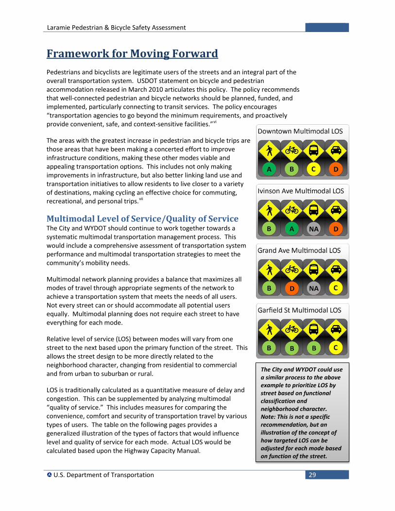
Multimodal Level of Service/Quality of Service The City and WYDOT should continue to work together towards a systematic multimodal transportation management process. This would include a comprehensive assessment of transportation system performance and multimodal transportation strategies to meet the community’s mobility needs.
Multimodal network planning provides a balance that maximizes all modes of travel through appropriate segments of the network to achieve a transportation system that meets the needs of all users. Not every street can or should accommodate all potential users equally. Multimodal planning does not require each street to have everything for each mode.
Relative level of service (LOS) between modes will vary from one street to the next based upon the primary function of the street. This allows the street design to be more directly related to the neighborhood character, changing from residential to commercial and from urban to suburban or rural.
LOS is traditionally calculated as a quantitative measure of delay and congestion. This can be supplemented by analyzing multimodal “quality of service.” This includes measures for comparing the convenience, comfort and security of transportation travel by various types of users. The table on the following pages provides a generalized illustration of the types of factors that would influence level and quality of service for each mode. Actual LOS would be calculated based upon the Highway Capacity Manual.
The City and WYDOT could use a similar process to the above example to prioritize LOS by street based on functional classification and neighborhood character. Note: This is not a specific recommendation, but an illustration of the concept of how targeted LOS can be adjusted for each mode based on function of the street.
Laramie Pedestrian & Bicycle Safety Assessment
U.S. Department of Transportation 30
Multimodal Level of Service/Quality of Service
LOS Pedestrian Bicycle Transit Motor Vehicle
A • Adequate sidewalk width and condition
• Walking speeds are freely selected, and conflicts between pedestrians unlikely
• Good separation/buffers from traffic
• Low traffic speeds and volumes • Convenient signalized crosswalks • Limited driveway access crossing
sidewalk • Small block size and good
connectivity • Walkability between buildings
• Multimodal pathway or bike lane
• Adequate width of bicycle travel lanes
• Low conflicts with pedestrians • Average bicycle travel speeds
of 14 mph • High street connectivity • Low traffic volume and speed • Low percentage of trucks • Good pavement condition
• 19-24 hours of service
• Service frequency of 6 or more vehicles/hour
• Less than 0.5 passengers/seat
• Reliability of 95% to 100% on time
• Transit shelters • Direct pedestrian
access to transit stop
• Free-flow operations.
• Traffic flows at or above the posted speed limit and motorists have complete mobility between lanes.
• Minimal delays of less than 10 seconds at signalized intersections.
B • Adequate sidewalk width and condition
• Sufficient area for pedestrians to select walking speeds freely to bypass other pedestrians
• Good separation/buffers from traffic
• Low traffic speeds and volumes • Convenient signalized crosswalks • Limited driveway access crossing
sidewalk • Small block size and good
connectivity • Walkability between buildings
• Multimodal pathway or bike lane
• Adequate width of bicycle travel lanes
• Low conflicts with pedestrians • Average bicycle travel speeds
of 9-14 mph • High street connectivity • Low traffic volume and speed • Low percentage of trucks • Good pavement condition
• 17-18 hours of service/ day
• Service frequency of 5-6 vehicles/hour
• 0.51-.75 passengers/ seat
• Reliability of 90% to 95% on time
• Transit shelters • Convenient
pedestrian access to transit stop
• Reasonably unimpeded operations.
• Speeds are maintained, maneuverability within the traffic stream is slightly restricted.
• Low delays of 10 – 20 seconds at signalized intersections.
C • Adequate sidewalk width • Space is sufficient for normal
walking speeds and bypassing other pedestrians with crossing movements causing minor conflicts
• Good separation/buffers from traffic
• Moderate traffic speeds and volumes.
• Widely separated pedestrian crossing signals
• Moderate driveway access crossing sidewalk
• Medium block size and moderate connectivity
• Some conflicts when walking to building entrances
• Multimodal pathway, bike lane or shared lane
• Inadequate width of bicycle travel lanes based upon amount of bicycle and pedestrian traffic
• Moderate conflict with pedestrians
• Average bicycle travel speeds of 7-9 mph
• Moderate street connectivity • Moderate traffic volume and
speed • Moderate percentage of
trucks • Good pavement condition
• 14-16 hours of service/day
• Service frequency of 3-4 vehicles/hour
• 0.76-1 passengers/ seat
• Reliability of 85% to 90% on time
• Transit stop benches • Basic pedestrian
access to transit stops
• Stable operations. • Ability to maneuver
through lanes is noticeably restricted and lane changes require more driver awareness.
• Average delays of 20 -35 seconds at signalized intersections.
Laramie Pedestrian & Bicycle Safety Assessment
U.S. Department of Transportation 31
LOS Pedestrian Bicycle Transit Motor Vehicle
D • Inadequate sidewalk width • Freedom to select individual
walking speed and bypass other pedestrians is restricted; crossing movements face a high probability of conflict
• Limited separation or buffer from traffic
• High traffic speeds and volumes • Limited pedestrian crossing
signals • Frequent driveway access
crossing sidewalk • Large block size and poor
connectivity • Difficulty walking to building
entrances
• Lack of pathway or bike lane • Bicycle sharing vehicular travel
lanes or sidewalks • Moderate conflict with
pedestrians • Average bicycle travel speeds
of 5-7 mph • Moderate street connectivity • Moderate traffic volume and
speed • Moderate percentage of
trucks • Good pavement condition
• 11-13 hours of service/ day
• Service frequency of 2 vehicles/hour
• 1-1.25 passengers/ seat
• Reliability of 80% to 85% on time
• Limited transit stop amenities
• Basic pedestrian access to transit stops
• Increased delay and decreased travel speed.
• Freedom to maneuver within the traffic stream is much more limited and driver comfort levels decrease.
• Longer delays of 35 – 55 seconds at signalized intersections.
E • Inadequate sidewalk width • Virtually all pedestrians restrict
their normal walking speed and space is not sufficient for passing slower pedestrians; cross movements are possible only with extreme difficulty
• Sidewalk adjacent to vehicular travel lanes with no buffers from traffic
• High traffic speeds and volumes • No pedestrian crossing signals • Frequent driveway access
crossing sidewalk • Large block size and poor
connectivity • Difficulty walking to building
entrances
• Lack of pathway or bike lane • Bicycle sharing vehicular travel
lanes or sidewalks • High conflict with pedestrians. • Average bicycle travel speeds
less than 5 mph • Poor street connectivity • High traffic volume and speed • High percentage of trucks • Fair pavement condition
• 4-10 hours of service/day
• Service frequency of 1 vehicle/hour
• 1.26-1.5 passengers/seat
• Reliability of 75% to 80% on time
• No transit stop amenities
• Lower quality pedestrian access to transit stop
• Unstable flow, operating at capacity.
• Significant delays and high volumes.
• Flow becomes irregular and speed varies rapidly because there are virtually no usable gaps to maneuver in the traffic stream and speeds rarely reach the posted limit.
• High delay of 55 - 80 seconds at signalized intersections.
F • Limited or no sidewalk • No barriers or buffers from traffic • High traffic speeds and volumes • No pedestrian crossing signals • Frequent vehicular/pedestrian
conflicts • Large block size and poor
connectivity • Difficulty walking to building
entrances
• Lack of pathway or bike lane • Bicycle sharing narrow
vehicular travel lanes or not allowed
• Average bicycle travel speeds of less than 4 mph
• Poor street connectivity • High traffic volume and speed • High percentage of trucks • Poor pavement condition
• Limited or no service
• 1.5+ passengers/ seat
• Reliability less than 75% on time
• No transit stop amenities
• No pedestrian facility to transit stops
• Forced or breakdown flow.
• Street flow at extremely low speeds.
• Travel time cannot be predicted, with more demand than capacity.
• Unacceptable delays of more than 80 seconds at signalized intersections
The above table is a generalized description of LOS/QOS. Actual LOS would be calculated based upon the Highway Capacity Manual.

Laramie Pedestrian & Bicycle Safety Assessment
U.S. Department of Transportation 32
Laramie Pedestrian & Bicycle Safety Assessment
U.S. Department of Transportation 33
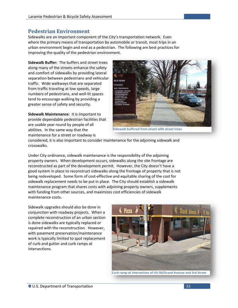
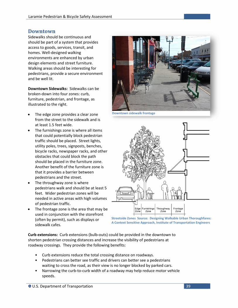
Pedestrian Environment Sidewalks are an important component of the City’s transportation network. Even where the primary means of transportation by automobile or transit, most trips in an urban environment begin and end as a pedestrian. The following are best practices for improving the quality of the pedestrian environment.
Sidewalk Buffer: The buffers and street trees along many of the streets enhance the safety and comfort of sidewalks by providing lateral separation between pedestrians and vehicular traffic. Wide walkways that are separated from traffic traveling at low speeds, large numbers of pedestrians, and well-lit spaces tend to encourage walking by providing a greater sense of safety and security.
Sidewalk Maintenance: It is important to provide dependable pedestrian facilities that are usable year round by people of all abilities. In the same way that the maintenance for a street or roadway is considered, it is also important to consider maintenance for the adjoining sidewalk and crosswalks.
Under City ordinance, sidewalk maintenance is the responsibility of the adjoining property owners. When development occurs, sidewalks along the site frontage are reconstructed as part of the development permit. However, the City doesn’t have a good system in place to reconstruct sidewalks along the frontage of property that is not being redeveloped. Some form of cost-effective and equitable sharing of the cost for sidewalk replacement needs to be put in place. The City should establish a sidewalk maintenance program that shares costs with adjoining property owners, supplements with funding from other sources, and maximizes cost efficiencies of sidewalk maintenance costs.
Sidewalk upgrades should also be done in conjunction with roadway projects. When a complete reconstruction of an urban section is done sidewalks are typically replaced or repaired with the reconstruction. However, with pavement preservation/maintenance work is typically limited to spot replacement of curb and gutter and curb ramps at intersections.
Sidewalk buffered from street with street trees
Curb ramp at intersection of US-30/Grand Avenue and 3rd Street
Laramie Pedestrian & Bicycle Safety Assessment
U.S. Department of Transportation 34
Curb ramps: Curb ramps provide access between the sidewalk and roadway for people using wheelchairs, strollers, walkers, crutches, or who have mobility restrictions that make it difficult to step up and down high curbs. Per ADA, curb ramps must be installed at all locations where there are pedestrian crossings.
Curb ramps must have a slope of no more than 1:12 (must not exceed 1 in./ft. or a maximum grade of 8.33 percent) and a maximum slope on any side flares of 1:10. More information on the specifications for curb ramps can be found in the Public Rights of Way Accessibility Guidelines (PROWAG).
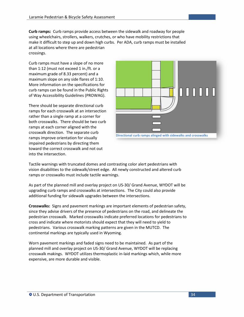
There should be separate directional curb ramps for each crosswalk at an intersection rather than a single ramp at a corner for both crosswalks. There should be two curb ramps at each corner aligned with the crosswalk direction. The separate curb ramps improve orientation for visually impaired pedestrians by directing them toward the correct crosswalk and not out into the intersection.
Tactile warnings with truncated domes and contrasting color alert pedestrians with vision disabilities to the sidewalk/street edge. All newly constructed and altered curb ramps or crosswalks must include tactile warnings.
As part of the planned mill and overlay project on US-30/ Grand Avenue, WYDOT will be upgrading curb ramps and crosswalks at intersections. The City could also provide additional funding for sidewalk upgrades between the intersections.
Crosswalks: Signs and pavement markings are important elements of pedestrian safety, since they advise drivers of the presence of pedestrians on the road, and delineate the pedestrian crosswalk. Marked crosswalks indicate preferred locations for pedestrians to cross and indicate where motorists should expect that they will need to yield to pedestrians. Various crosswalk marking patterns are given in the MUTCD. The continental markings are typically used in Wyoming.
Worn pavement markings and faded signs need to be maintained. As part of the planned mill and overlay project on US-30/ Grand Avenue, WYDOT will be replacing crosswalk makings. WYDOT utilizes thermoplastic in-laid markings which, while more expensive, are more durable and visible.
Directional curb ramps alinged with sidewalks and crosswalks
Laramie Pedestrian & Bicycle Safety Assessment
U.S. Department of Transportation 35
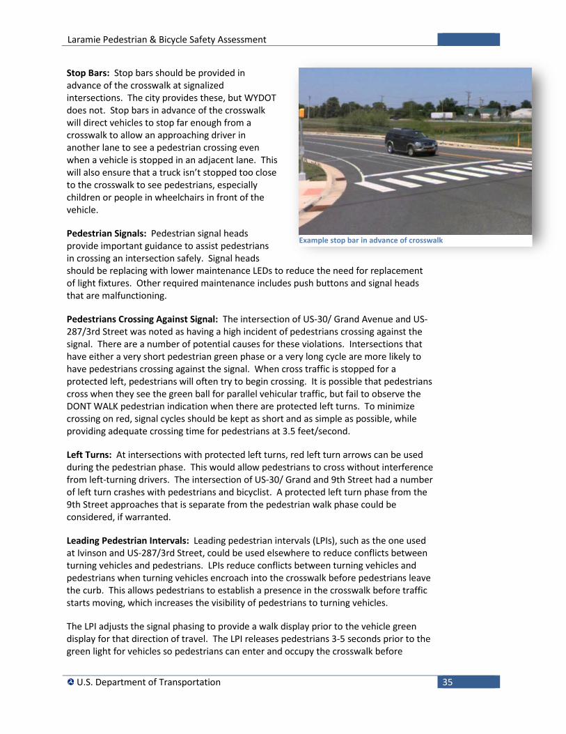
Stop Bars: Stop bars should be provided in advance of the crosswalk at signalized intersections. The city provides these, but WYDOT does not. Stop bars in advance of the crosswalk will direct vehicles to stop far enough from a crosswalk to allow an approaching driver in another lane to see a pedestrian crossing even when a vehicle is stopped in an adjacent lane. This will also ensure that a truck isn’t stopped too close to the crosswalk to see pedestrians, especially children or people in wheelchairs in front of the vehicle.
Pedestrian Signals: Pedestrian signal heads provide important guidance to assist pedestrians in crossing an intersection safely. Signal heads should be replacing with lower maintenance LEDs to reduce the need for replacement of light fixtures. Other required maintenance includes push buttons and signal heads that are malfunctioning.
Pedestrians Crossing Against Signal: The intersection of US-30/ Grand Avenue and US-287/3rd Street was noted as having a high incident of pedestrians crossing against the signal. There are a number of potential causes for these violations. Intersections that have either a very short pedestrian green phase or a very long cycle are more likely to have pedestrians crossing against the signal. When cross traffic is stopped for a protected left, pedestrians will often try to begin crossing. It is possible that pedestrians cross when they see the green ball for parallel vehicular traffic, but fail to observe the DONT WALK pedestrian indication when there are protected left turns. To minimize crossing on red, signal cycles should be kept as short and as simple as possible, while providing adequate crossing time for pedestrians at 3.5 feet/second.
Left Turns: At intersections with protected left turns, red left turn arrows can be used during the pedestrian phase. This would allow pedestrians to cross without interference from left-turning drivers. The intersection of US-30/ Grand and 9th Street had a number of left turn crashes with pedestrians and bicyclist. A protected left turn phase from the 9th Street approaches that is separate from the pedestrian walk phase could be considered, if warranted.
Leading Pedestrian Intervals: Leading pedestrian intervals (LPIs), such as the one used at Ivinson and US-287/3rd Street, could be used elsewhere to reduce conflicts between turning vehicles and pedestrians. LPIs reduce conflicts between turning vehicles and pedestrians when turning vehicles encroach into the crosswalk before pedestrians leave the curb. This allows pedestrians to establish a presence in the crosswalk before traffic starts moving, which increases the visibility of pedestrians to turning vehicles.
The LPI adjusts the signal phasing to provide a walk display prior to the vehicle green display for that direction of travel. The LPI releases pedestrians 3-5 seconds prior to the green light for vehicles so pedestrians can enter and occupy the crosswalk before
Example stop bar in advance of crosswalk
Laramie Pedestrian & Bicycle Safety Assessment
U.S. Department of Transportation 36
turning drivers enter it. The MUTCD states that: “LPI should be at least 3 seconds in duration and should be timed to allow pedestrians to cross at least one lane of traffic or, in the case of a large corner radius, to travel far enough for pedestrians to establish their position ahead of the turning traffic before the turning traffic is released.”
Intersections with LPI must be equipped with Accessible Pedestrian Signal (APS). Pedestrians with vision impairment rely on the sound of moving traffic to know when to begin crossing. The sound of parallel moving traffic is delayed at signals equipped with LPI and may cause pedestrian with vision impairment to start their crossing late.
Exclusive Pedestrian Phase: If an intersection has particularly high pedestrian traffic, adding an exclusive pedestrian phase might be considered as an option. This has been done at the intersection of Ivinson Avenue and 15th Street.
Curb Radii: Reducing the curb radii at the corners of an intersection can help reduce the speed of turning vehicles, improve sight distance between pedestrians and motorists, and shorten the crossing distance for pedestrians. The smallest practical actual curb radii should be used at intersections. This may vary from 15 to 30 feet based on the roadway function and the design vehicle.
Medians: Median islands (or pedestrian crossing islands) allow pedestrians to cross one direction of motor vehicle traffic at a time and provide pedestrians with a place of refuge. Center crossing islands allow pedestrians to deal with only one direction of traffic at a time, and they enable pedestrians to stop partway across the street and wait for an adequate gap in traffic before crossing the second half of the street. Crossing islands can be constructed so that crossing pedestrians are forced to the right to view oncoming traffic as they are halfway through the crossing.viiiix
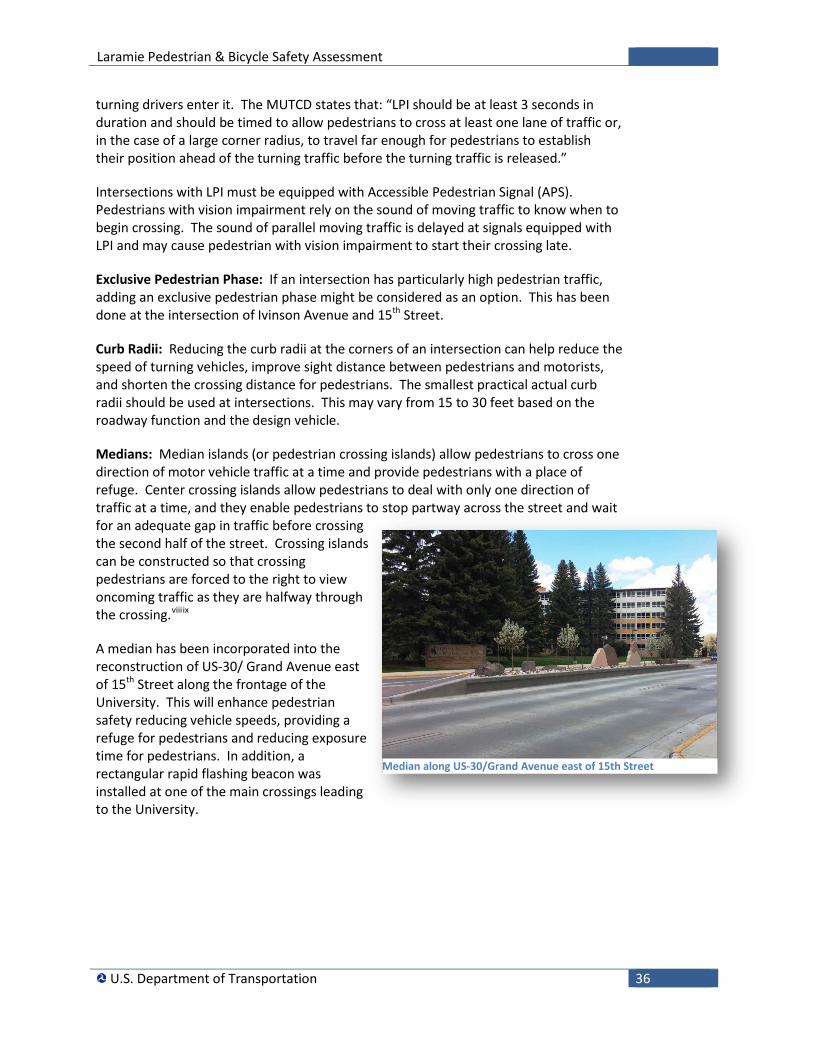
A median has been incorporated into the reconstruction of US-30/ Grand Avenue east of 15th Street along the frontage of the University. This will enhance pedestrian safety reducing vehicle speeds, providing a refuge for pedestrians and reducing exposure time for pedestrians. In addition, a rectangular rapid flashing beacon was installed at one of the main crossings leading to the University.
Median along US-30/Grand Avenue east of 15th Street
Laramie Pedestrian & Bicycle Safety Assessment
U.S. Department of Transportation 37
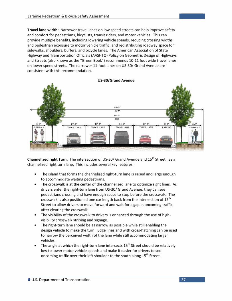
Travel lane width: Narrower travel lanes on low speed streets can help improve safety and comfort for pedestrians, bicyclists, transit riders, and motor vehicles. This can provide multiple benefits, including lowering vehicle speeds, reducing crossing widths and pedestrian exposure to motor vehicle traffic, and redistributing roadway space for sidewalks, shoulders, buffers, and bicycle lanes. The American Association of State Highway and Transportation Officials (AASHTO) Policy on Geometric Design of Highways and Streets (also known as the “Green Book”) recommends 10-11 foot wide travel lanes on lower speed streets. The narrower 11-foot lanes on US-30/ Grand Avenue are consistent with this recommendation.
US-30/Grand Avenue
Channelized right Turn: The intersection of US-30/ Grand Avenue and 15th Street has a channelized right turn lane. This includes several key features:
• The island that forms the channelized right-turn lane is raised and large enough to accommodate waiting pedestrians.
• The crosswalk is at the center of the channelized lane to optimize sight lines. As drivers enter the right-turn lane from US-30/ Grand Avenue, they can see pedestrians crossing and have enough space to stop before the crosswalk. The crosswalk is also positioned one car length back from the intersection of 15th Street to allow drivers to move forward and wait for a gap in oncoming traffic after clearing the crosswalk.
• The visibility of the crosswalk to drivers is enhanced through the use of high-visibility crosswalk striping and signage.
• The right-turn lane should be as narrow as possible while still enabling the design vehicle to make the turn. Edge lines and with cross-hatching can be used to narrow the perceived width of the lane while still accommodating larger vehicles.
• The angle at which the right-turn lane intersects 15th Street should be relatively low to lower motor vehicle speeds and make it easier for drivers to see oncoming traffic over their left shoulder to the south along 15th Street.
Laramie Pedestrian & Bicycle Safety Assessment
U.S. Department of Transportation 38
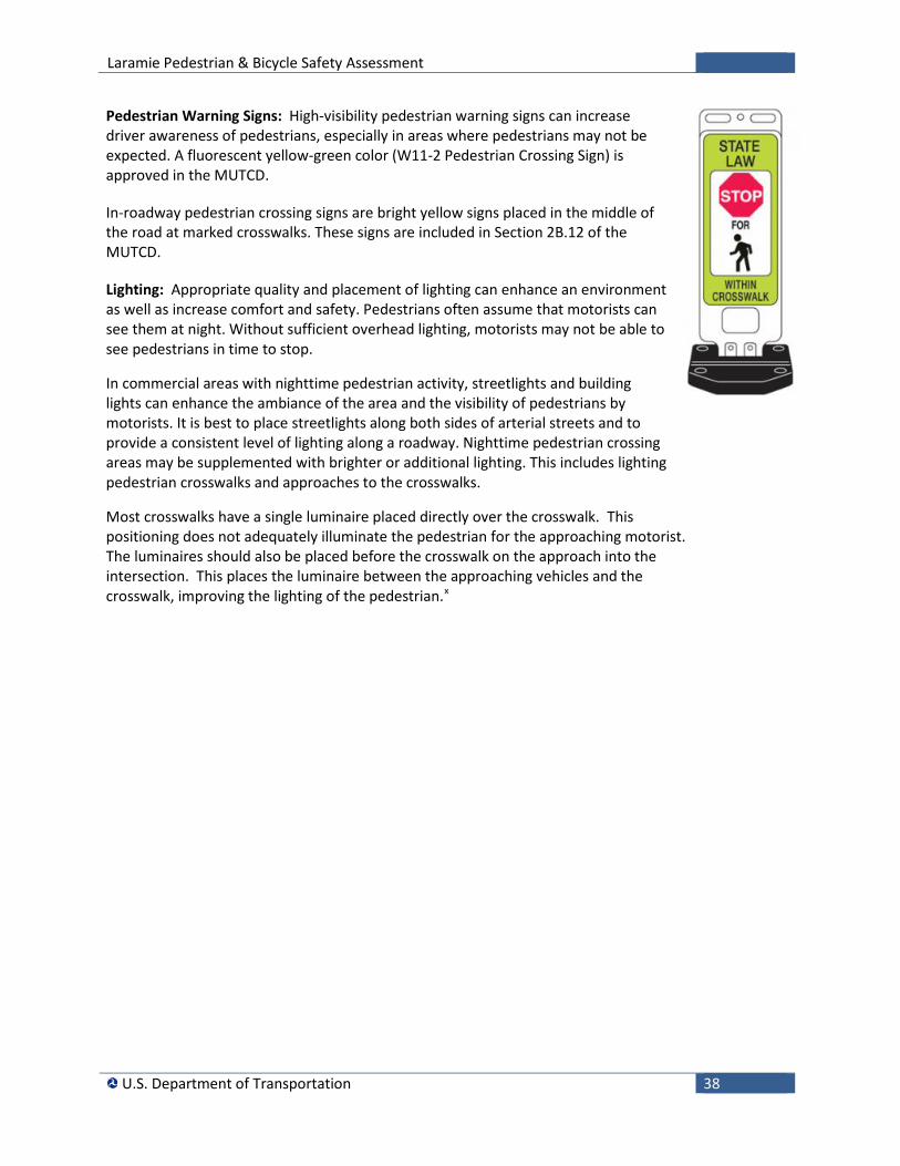
Pedestrian Warning Signs: High-visibility pedestrian warning signs can increase driver awareness of pedestrians, especially in areas where pedestrians may not be expected. A fluorescent yellow-green color (W11-2 Pedestrian Crossing Sign) is approved in the MUTCD.
In-roadway pedestrian crossing signs are bright yellow signs placed in the middle of the road at marked crosswalks. These signs are included in Section 2B.12 of the MUTCD.
Lighting: Appropriate quality and placement of lighting can enhance an environment as well as increase comfort and safety. Pedestrians often assume that motorists can see them at night. Without sufficient overhead lighting, motorists may not be able to see pedestrians in time to stop.
In commercial areas with nighttime pedestrian activity, streetlights and building lights can enhance the ambiance of the area and the visibility of pedestrians by motorists. It is best to place streetlights along both sides of arterial streets and to provide a consistent level of lighting along a roadway. Nighttime pedestrian crossing areas may be supplemented with brighter or additional lighting. This includes lighting pedestrian crosswalks and approaches to the crosswalks.
Most crosswalks have a single luminaire placed directly over the crosswalk. This positioning does not adequately illuminate the pedestrian for the approaching motorist. The luminaires should also be placed before the crosswalk on the approach into the intersection. This places the luminaire between the approaching vehicles and the crosswalk, improving the lighting of the pedestrian.x
Laramie Pedestrian & Bicycle Safety Assessment
U.S. Department of Transportation 39
Downtown Sidewalks should be continuous and should be part of a system that provides access to goods, services, transit, and homes. Well-designed walking environments are enhanced by urban design elements and street furniture. Walking areas should be interesting for pedestrians, provide a secure environment and be well lit.
Downtown Sidewalks: Sidewalks can be broken-down into four zones: curb, furniture, pedestrian, and frontage, as illustrated to the right.
• The edge zone provides a clear zone from the street to the sidewalk and is at least 1.5 feet wide.
• The furnishings zone is where all items that could potentially block pedestrian traffic should be placed. Street lights, utility poles, trees, signposts, benches, bicycle racks, newspaper racks, and other obstacles that could block the path should be placed in the furniture zone. Another benefit of the furniture zone is that it provides a barrier between pedestrians and the street.
• The throughway zone is where pedestrians walk and should be at least 5 feet. Wider pedestrian zones will be needed in active areas with high volumes of pedestrian traffic.
• The frontage zone is the area that may be used in conjunction with the storefront (often by permit), such as displays or sidewalk cafes.
Curb extensions: Curb extensions (bulb-outs) could be provided in the downtown to shorten pedestrian crossing distances and increase the visibility of pedestrians at roadway crossings. They provide the following benefits:
• Curb extensions reduce the total crossing distance on roadways. • Pedestrians can better see traffic and drivers can better see a pedestrians
waiting to cross the road, as their view is no longer blocked by parked cars. • Narrowing the curb-to-curb width of a roadway may help reduce motor vehicle
speeds.
Streetside Zones Source: Designing Walkable Urban Thoroughfares: A Context Sensitive Approach, Institute of Transportation Engineers
Downtown sidewalk frontage
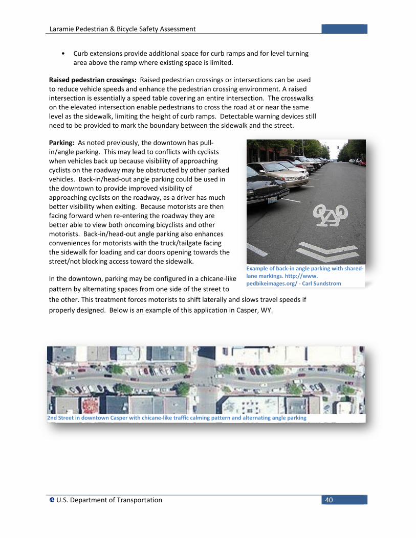
Laramie Pedestrian & Bicycle Safety Assessment
U.S. Department of Transportation 40
• Curb extensions provide additional space for curb ramps and for level turning area above the ramp where existing space is limited.
Raised pedestrian crossings: Raised pedestrian crossings or intersections can be used to reduce vehicle speeds and enhance the pedestrian crossing environment. A raised intersection is essentially a speed table covering an entire intersection. The crosswalks on the elevated intersection enable pedestrians to cross the road at or near the same level as the sidewalk, limiting the height of curb ramps. Detectable warning devices still need to be provided to mark the boundary between the sidewalk and the street.
Parking: As noted previously, the downtown has pull-in/angle parking. This may lead to conflicts with cyclists when vehicles back up because visibility of approaching cyclists on the roadway may be obstructed by other parked vehicles. Back-in/head-out angle parking could be used in the downtown to provide improved visibility of approaching cyclists on the roadway, as a driver has much better visibility when exiting. Because motorists are then facing forward when re-entering the roadway they are better able to view both oncoming bicyclists and other motorists. Back-in/head-out angle parking also enhances conveniences for motorists with the truck/tailgate facing the sidewalk for loading and car doors opening towards the street/not blocking access toward the sidewalk.
In the downtown, parking may be configured in a chicane-like pattern by alternating spaces from one side of the street to the other. This treatment forces motorists to shift laterally and slows travel speeds if properly designed. Below is an example of this application in Casper, WY.
Example of back-in angle parking with shared-lane markings. http://www. pedbikeimages.org/ - Carl Sundstrom
2nd Street in downtown Casper with chicane-like traffic calming pattern and alternating angle parking
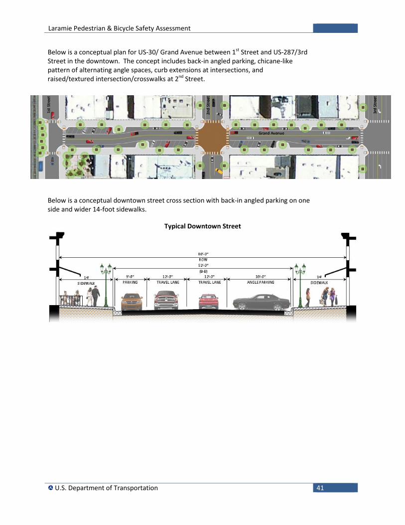
Laramie Pedestrian & Bicycle Safety Assessment
U.S. Department of Transportation 41
Below is a conceptual plan for US-30/ Grand Avenue between 1st Street and US-287/3rd Street in the downtown. The concept includes back-in angled parking, chicane-like pattern of alternating angle spaces, curb extensions at intersections, and raised/textured intersection/crosswalks at 2nd Street.
Below is a conceptual downtown street cross section with back-in angled parking on one side and wider 14-foot sidewalks.
Typical Downtown Street
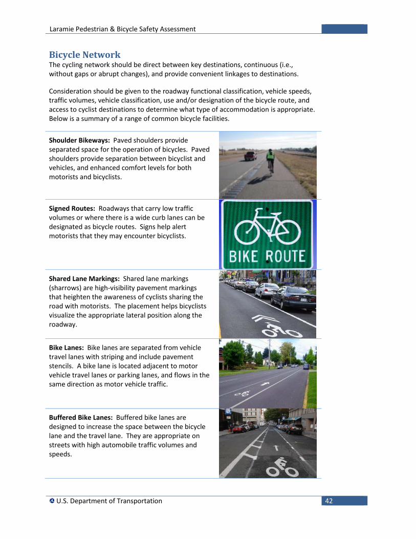
Laramie Pedestrian & Bicycle Safety Assessment
U.S. Department of Transportation 42
Bicycle Network The cycling network should be direct between key destinations, continuous (i.e., without gaps or abrupt changes), and provide convenient linkages to destinations.
Consideration should be given to the roadway functional classification, vehicle speeds, traffic volumes, vehicle classification, use and/or designation of the bicycle route, and access to cyclist destinations to determine what type of accommodation is appropriate. Below is a summary of a range of common bicycle facilities.
Shoulder Bikeways: Paved shoulders provide separated space for the operation of bicycles. Paved shoulders provide separation between bicyclist and vehicles, and enhanced comfort levels for both motorists and bicyclists.
Signed Routes: Roadways that carry low traffic volumes or where there is a wide curb lanes can be designated as bicycle routes. Signs help alert motorists that they may encounter bicyclists.
Shared Lane Markings: Shared lane markings (sharrows) are high-visibility pavement markings that heighten the awareness of cyclists sharing the road with motorists. The placement helps bicyclists visualize the appropriate lateral position along the roadway.
Bike Lanes: Bike lanes are separated from vehicle travel lanes with striping and include pavement stencils. A bike lane is located adjacent to motor vehicle travel lanes or parking lanes, and flows in the same direction as motor vehicle traffic.
Buffered Bike Lanes: Buffered bike lanes are designed to increase the space between the bicycle lane and the travel lane. They are appropriate on streets with high automobile traffic volumes and speeds.
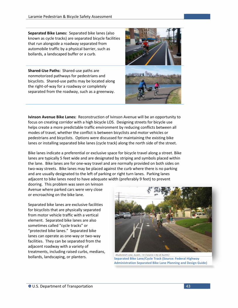
Laramie Pedestrian & Bicycle Safety Assessment
U.S. Department of Transportation 43
Separated Bike Lanes: Separated bike lanes (also known as cycle tracks) are separated bicycle facilities that run alongside a roadway separated from automobile traffic by a physical barrier, such as bollards, a landscaped buffer or a curb.
Shared-Use Paths: Shared-use paths are nonmotorized pathways for pedestrians and bicyclists. Shared-use paths may be located along the right-of-way for a roadway or completely separated from the roadway, such as a greenway.
Ivinson Avenue Bike Lanes: Reconstruction of Ivinson Avenue will be an opportunity to focus on creating corridor with a high bicycle LOS. Designing streets for bicycle use helps create a more predictable traffic environment by reducing conflicts between all modes of travel, whether the conflict is between bicyclists and motor vehicles or pedestrians and bicyclists. Options were discussed for maintaining the existing bike lanes or installing separated bike lanes (cycle track) along the north side of the street.
Bike lanes indicate a preferential or exclusive space for bicycle travel along a street. Bike lanes are typically 5 feet wide and are designated by striping and symbols placed within the lane. Bike lanes are for one-way travel and are normally provided on both sides on two-way streets. Bike lanes may be placed against the curb where there is no parking and are usually designated to the left of parking or right turn lanes. Parking lanes adjacent to bike lanes need to have adequate width (preferably 9 feet) to prevent dooring. This problem was seen on Ivinson Avenue where parked cars were very close or encroaching on the bike lane.
Separated bike lanes are exclusive facilities for bicyclists that are physically separated from motor vehicle traffic with a vertical element. Separated bike lanes are also sometimes called “cycle tracks” or “protected bike lanes.” Separated bike lanes can operate as one-way or two-way facilities. They can be separated from the adjacent roadway with a variety of treatments, including raised curbs, medians, bollards, landscaping, or planters.
Separated Bike Lane/Cycle Track (Source: Federal Highway Administration Separated Bike Lane Planning and Design Guide)
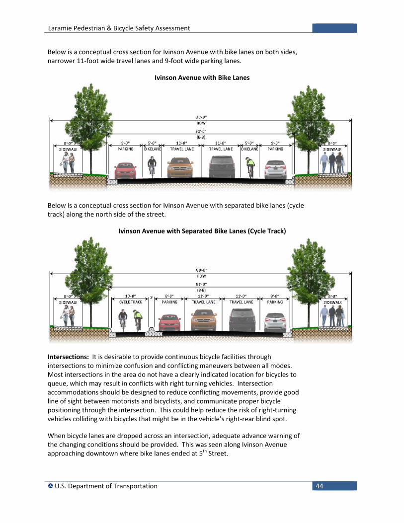
Laramie Pedestrian & Bicycle Safety Assessment
U.S. Department of Transportation 44
Below is a conceptual cross section for Ivinson Avenue with bike lanes on both sides, narrower 11-foot wide travel lanes and 9-foot wide parking lanes.
Ivinson Avenue with Bike Lanes
Below is a conceptual cross section for Ivinson Avenue with separated bike lanes (cycle track) along the north side of the street.
Ivinson Avenue with Separated Bike Lanes (Cycle Track)
Intersections: It is desirable to provide continuous bicycle facilities through intersections to minimize confusion and conflicting maneuvers between all modes. Most intersections in the area do not have a clearly indicated location for bicycles to queue, which may result in conflicts with right turning vehicles. Intersection accommodations should be designed to reduce conflicting movements, provide good line of sight between motorists and bicyclists, and communicate proper bicycle positioning through the intersection. This could help reduce the risk of right-turning vehicles colliding with bicycles that might be in the vehicle’s right-rear blind spot.
When bicycle lanes are dropped across an intersection, adequate advance warning of the changing conditions should be provided. This was seen along Ivinson Avenue approaching downtown where bike lanes ended at 5th Street.
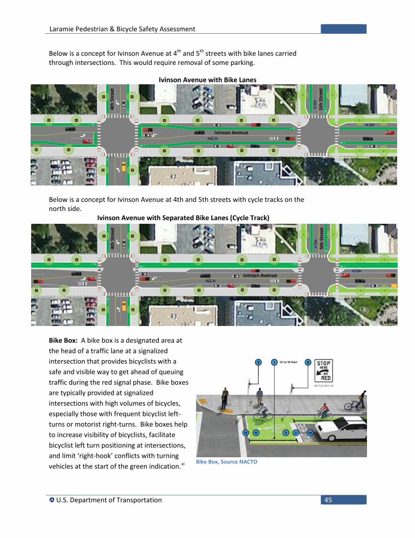
Laramie Pedestrian & Bicycle Safety Assessment
U.S. Department of Transportation 45
Below is a concept for Ivinson Avenue at 4th and 5th streets with bike lanes carried through intersections. This would require removal of some parking.
Ivinson Avenue with Bike Lanes
Below is a concept for Ivinson Avenue at 4th and 5th streets with cycle tracks on the north side.
Ivinson Avenue with Separated Bike Lanes (Cycle Track)
Bike Box: A bike box is a designated area at the head of a traffic lane at a signalized intersection that provides bicyclists with a safe and visible way to get ahead of queuing traffic during the red signal phase. Bike boxes are typically provided at signalized intersections with high volumes of bicycles, especially those with frequent bicyclist left-turns or motorist right-turns. Bike boxes help to increase visibility of bicyclists, facilitate bicyclist left turn positioning at intersections, and limit ‘right-hook’ conflicts with turning vehicles at the start of the green indication.xi
Bike Box, Source NACTO
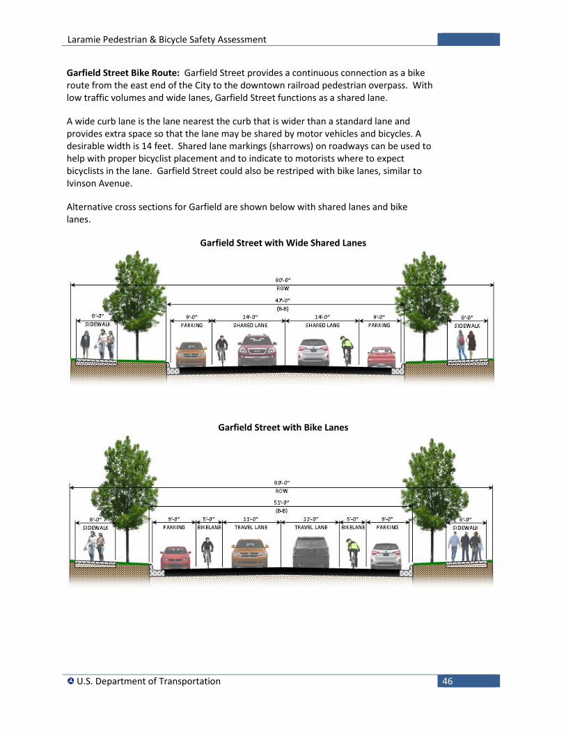
Laramie Pedestrian & Bicycle Safety Assessment
U.S. Department of Transportation 46
Garfield Street Bike Route: Garfield Street provides a continuous connection as a bike route from the east end of the City to the downtown railroad pedestrian overpass. With low traffic volumes and wide lanes, Garfield Street functions as a shared lane.
A wide curb lane is the lane nearest the curb that is wider than a standard lane and provides extra space so that the lane may be shared by motor vehicles and bicycles. A desirable width is 14 feet. Shared lane markings (sharrows) on roadways can be used to help with proper bicyclist placement and to indicate to motorists where to expect bicyclists in the lane. Garfield Street could also be restriped with bike lanes, similar to Ivinson Avenue.
Alternative cross sections for Garfield are shown below with shared lanes and bike lanes.
Garfield Street with Wide Shared Lanes
Garfield Street with Bike Lanes
Laramie Pedestrian & Bicycle Safety Assessment
U.S. Department of Transportation 47
Roadway Maintenance: Bicyclists are particularly vulnerable to sudden changes in the roadway surface, such as potholes or sudden drop-offs. Potholes, cracks (especially longitudinal cracks), buckling from heavy vehicle use, and lips at surface transitions along the riding surface are surface defects that may cause cyclists to lose control or fall. In addition to causing bicyclist falls, surface irregularities may contribute to a sudden weaving movement that may place the bicyclist in the path of a motorist. Therefore, providing smooth pavement surfaces is a key to maintaining a good level of service for bicyclists. Bicyclist considerations should also be incorporated into roadway maintenance, such as road patching, sweeping, and snow removal.xii
Drainage and Utilities: Drainage grates and utility covers may increase the potential for bicycle crashes and wheel damage. Consideration should be given to the use of drainage grates that are bicycle-compatible with transverse openings of an acceptable gap so that tires will not be trapped by slots parallel to the roadway.
Traffic rules: All road users need to observe traffic laws so that all users are exhibiting safe and consistent behavior. Cyclists on the road are subject to the same rules that govern vehicles, and therefore, they must obey traffic control devices that require vehicles to stop or slow down. The University has initiated educational programs on bicycle safety.
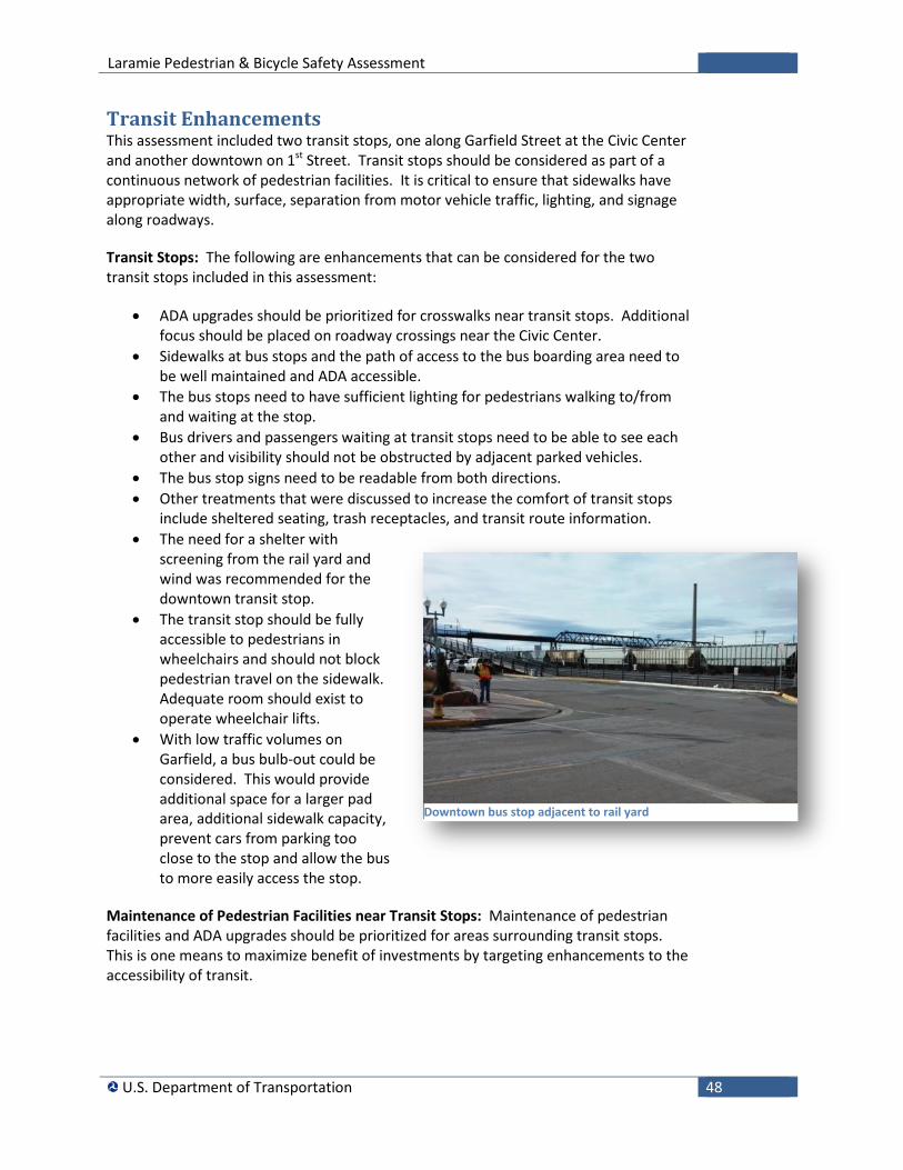
Laramie Pedestrian & Bicycle Safety Assessment
U.S. Department of Transportation 48
Transit Enhancements This assessment included two transit stops, one along Garfield Street at the Civic Center and another downtown on 1st Street. Transit stops should be considered as part of a continuous network of pedestrian facilities. It is critical to ensure that sidewalks have appropriate width, surface, separation from motor vehicle traffic, lighting, and signage along roadways.
Transit Stops: The following are enhancements that can be considered for the two transit stops included in this assessment:
• ADA upgrades should be prioritized for crosswalks near transit stops. Additional focus should be placed on roadway crossings near the Civic Center.
• Sidewalks at bus stops and the path of access to the bus boarding area need to be well maintained and ADA accessible.
• The bus stops need to have sufficient lighting for pedestrians walking to/from and waiting at the stop.
• Bus drivers and passengers waiting at transit stops need to be able to see each other and visibility should not be obstructed by adjacent parked vehicles.
• The bus stop signs need to be readable from both directions. • Other treatments that were discussed to increase the comfort of transit stops
include sheltered seating, trash receptacles, and transit route information. • The need for a shelter with
screening from the rail yard and wind was recommended for the downtown transit stop.
• The transit stop should be fully accessible to pedestrians in wheelchairs and should not block pedestrian travel on the sidewalk. Adequate room should exist to operate wheelchair lifts.
• With low traffic volumes on Garfield, a bus bulb-out could be considered. This would provide additional space for a larger pad area, additional sidewalk capacity, prevent cars from parking too close to the stop and allow the bus to more easily access the stop.
Maintenance of Pedestrian Facilities near Transit Stops: Maintenance of pedestrian facilities and ADA upgrades should be prioritized for areas surrounding transit stops. This is one means to maximize benefit of investments by targeting enhancements to the accessibility of transit.
Downtown bus stop adjacent to rail yard
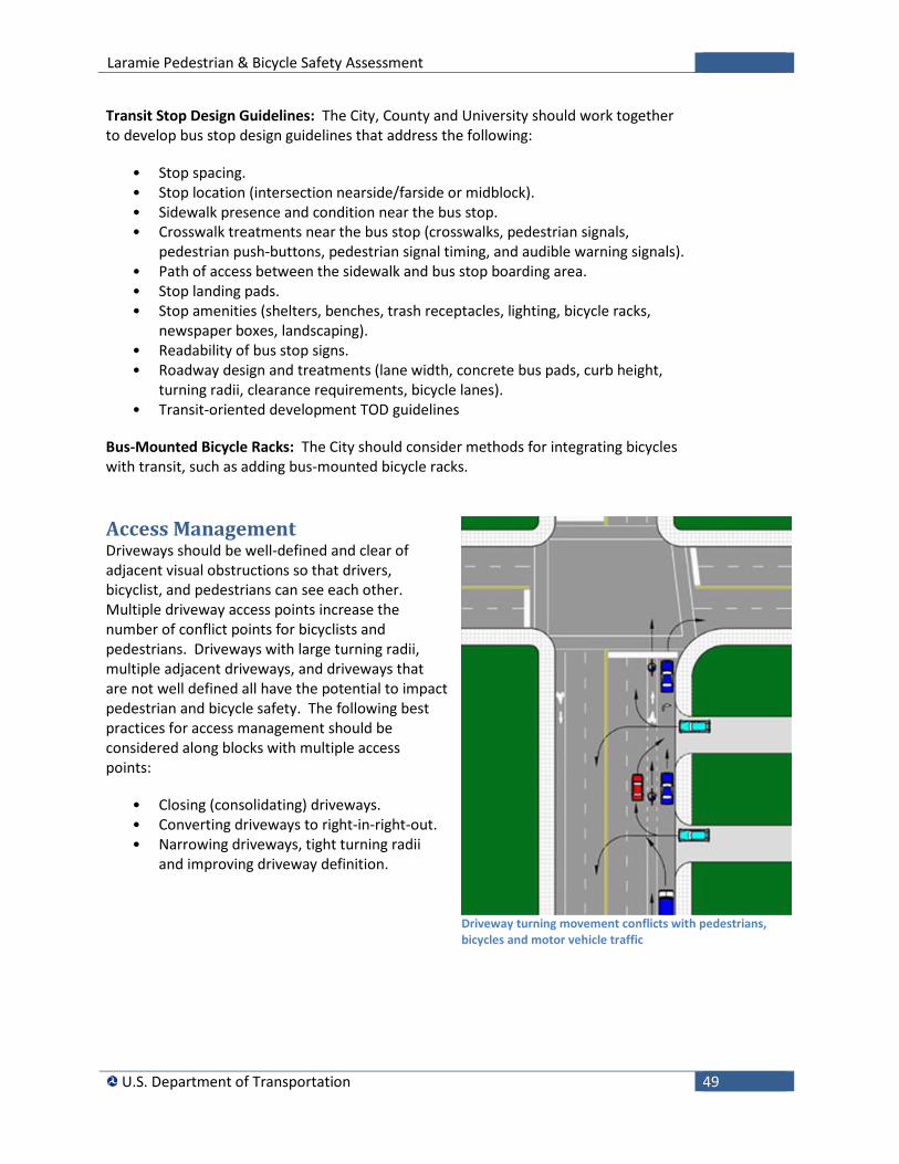
Laramie Pedestrian & Bicycle Safety Assessment
U.S. Department of Transportation 49
Transit Stop Design Guidelines: The City, County and University should work together to develop bus stop design guidelines that address the following:
• Stop spacing. • Stop location (intersection nearside/farside or midblock). • Sidewalk presence and condition near the bus stop. • Crosswalk treatments near the bus stop (crosswalks, pedestrian signals,
pedestrian push-buttons, pedestrian signal timing, and audible warning signals). • Path of access between the sidewalk and bus stop boarding area. • Stop landing pads. • Stop amenities (shelters, benches, trash receptacles, lighting, bicycle racks,
newspaper boxes, landscaping). • Readability of bus stop signs. • Roadway design and treatments (lane width, concrete bus pads, curb height,
turning radii, clearance requirements, bicycle lanes). • Transit-oriented development TOD guidelines
Bus-Mounted Bicycle Racks: The City should consider methods for integrating bicycles with transit, such as adding bus-mounted bicycle racks.
Access Management Driveways should be well-defined and clear of adjacent visual obstructions so that drivers, bicyclist, and pedestrians can see each other. Multiple driveway access points increase the number of conflict points for bicyclists and pedestrians. Driveways with large turning radii, multiple adjacent driveways, and driveways that are not well defined all have the potential to impact pedestrian and bicycle safety. The following best practices for access management should be considered along blocks with multiple access points:
• Closing (consolidating) driveways. • Converting driveways to right-in-right-out. • Narrowing driveways, tight turning radii
and improving driveway definition.
Driveway turning movement conflicts with pedestrians, bicycles and motor vehicle traffic
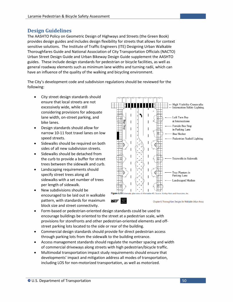
Laramie Pedestrian & Bicycle Safety Assessment
U.S. Department of Transportation 50
Design Guidelines The AASHTO Policy on Geometric Design of Highways and Streets (the Green Book) provides design guides and includes design flexibility for streets that allows for context sensitive solutions. The Institute of Traffic Engineers (ITE) Designing Urban Walkable Thoroughfares Guide and National Association of City Transportation Officials (NACTO) Urban Street Design Guide and Urban Bikeway Design Guide supplement the AASHTO guides. These include design standards for pedestrian or bicycle facilities, as well as general roadway elements such as minimum lane widths and turning radii, which can have an influence of the quality of the walking and bicycling environment.
The City’s development code and subdivision regulations should be reviewed for the following:
• City street design standards should ensure that local streets are not excessively wide, while still considering provisions for adequate lane width, on-street parking, and bike lanes.
• Design standards should allow for narrow 10-11 foot travel lanes on low speed streets.
• Sidewalks should be required on both sides of all new subdivision streets.
• Sidewalks should be detached from the curb to provide a buffer for street trees between the sidewalk and curb.
• Landscaping requirements should specify street trees along all sidewalks with a set number of trees per length of sidewalk.
• New subdivisions should be encouraged to be laid out in walkable pattern, with standards for maximum block size and street connectivity.
• Form-based or pedestrian-oriented design standards could be used to encourage buildings be oriented to the street at a pedestrian scale, with provisions for storefronts and other pedestrian-oriented elements and off-street parking lots located to the side or rear of the building.
• Commercial design standards should provide for direct pedestrian access through parking lots from the sidewalk to the building entrance.
• Access management standards should regulate the number spacing and width of commercial driveways along streets with high pedestrian/bicycle traffic.
• Multimodal transportation impact study requirements should ensure that developments’ impact and mitigation address all modes of transportation, including LOS for non-motorized transportation, as well as motorized.
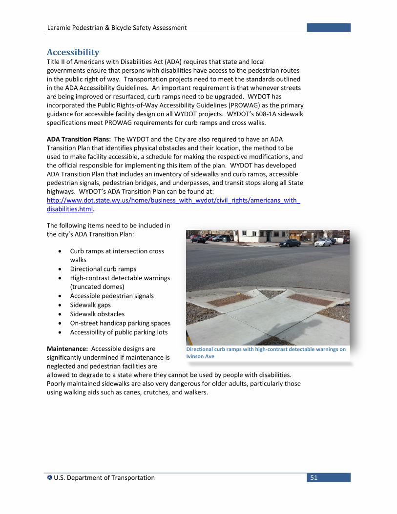
Laramie Pedestrian & Bicycle Safety Assessment
U.S. Department of Transportation 51
Accessibility Title II of Americans with Disabilities Act (ADA) requires that state and local governments ensure that persons with disabilities have access to the pedestrian routes in the public right of way. Transportation projects need to meet the standards outlined in the ADA Accessibility Guidelines. An important requirement is that whenever streets are being improved or resurfaced, curb ramps need to be upgraded. WYDOT has incorporated the Public Rights-of-Way Accessibility Guidelines (PROWAG) as the primary guidance for accessible facility design on all WYDOT projects. WYDOT’s 608-1A sidewalk specifications meet PROWAG requirements for curb ramps and cross walks.
ADA Transition Plans: The WYDOT and the City are also required to have an ADA Transition Plan that identifies physical obstacles and their location, the method to be used to make facility accessible, a schedule for making the respective modifications, and the official responsible for implementing this item of the plan. WYDOT has developed ADA Transition Plan that includes an inventory of sidewalks and curb ramps, accessible pedestrian signals, pedestrian bridges, and underpasses, and transit stops along all State highways. WYDOT’s ADA Transition Plan can be found at: http://www.dot.state.wy.us/home/business_with_wydot/civil_rights/americans_with_disabilities.html.
The following items need to be included in the city’s ADA Transition Plan:
• Curb ramps at intersection cross walks
• Directional curb ramps • High-contrast detectable warnings
(truncated domes) • Accessible pedestrian signals • Sidewalk gaps • Sidewalk obstacles • On-street handicap parking spaces • Accessibility of public parking lots
Maintenance: Accessible designs are significantly undermined if maintenance is neglected and pedestrian facilities are allowed to degrade to a state where they cannot be used by people with disabilities. Poorly maintained sidewalks are also very dangerous for older adults, particularly those using walking aids such as canes, crutches, and walkers.
Directional curb ramps with high-contrast detectable warnings on Ivinson Ave
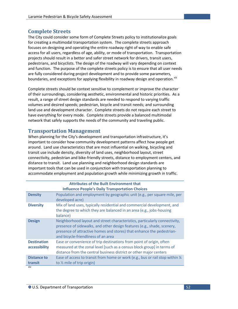
Laramie Pedestrian & Bicycle Safety Assessment
U.S. Department of Transportation 52
Complete Streets The City could consider some form of Complete Streets policy to institutionalize goals for creating a multimodal transportation system. The complete streets approach focuses on designing and operating the entire roadway right of way to enable safe access for all users, regardless of age, ability, or mode of transportation. Transportation projects should result in a better and safer street network for drivers, transit users, pedestrians, and bicyclists. The design of the roadway will vary depending on context and function. The purpose of the complete streets policy is to ensure that all user needs are fully considered during project development and to provide some parameters, boundaries, and exceptions for applying flexibility in roadway design and operation.xiii
Complete streets should be context sensitive to complement or improve the character of their surroundings, considering aesthetic, environmental and historic priorities. As a result, a range of street design standards are needed to respond to varying traffic volumes and desired speeds; pedestrian, bicycle and transit needs; and surrounding land use and development character. Complete streets do not require each street to have everything for every mode. Complete streets provide a balanced multimodal network that safely supports the needs of the community and traveling public.
Transportation Management When planning for the City’s development and transportation infrastructure, it’s important to consider how community development patterns affect how people get around. Land use characteristics that are most influential on walking, bicycling and transit use include density, diversity of land uses, neighborhood layout, street connectivity, pedestrian and bike-friendly streets, distance to employment centers, and distance to transit. Land use planning and neighborhood design standards are important tools that can be used in conjunction with transportation planning to accommodate employment and population growth while minimizing growth in traffic.
Attributes of the Built Environment that Influence People’s Daily Transportation Choices
Density Population and employment by geographic unit (e.g., per square mile, per developed acre)
Diversity Mix of land uses, typically residential and commercial development, and the degree to which they are balanced in an area (e.g., jobs-housing balance)
Design Neighborhood layout and street characteristics, particularly connectivity, presence of sidewalks, and other design features (e.g., shade, scenery, presence of attractive homes and stores) that enhance the pedestrian- and bicycle-friendliness of an area
Destination accessibility
Ease or convenience of trip destinations from point of origin, often measured at the zonal level [such as a census block group] in terms of distance from the central business district or other major centers
Distance to transit
Ease of access to transit from home or work (e.g., bus or rail stop within ¼ to ½ mile of trip origin)
xiv
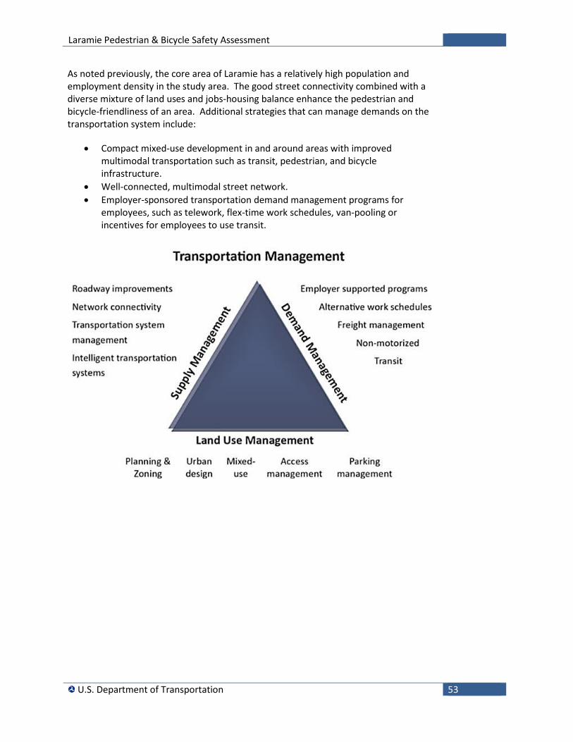
Laramie Pedestrian & Bicycle Safety Assessment
U.S. Department of Transportation 53
As noted previously, the core area of Laramie has a relatively high population and employment density in the study area. The good street connectivity combined with a diverse mixture of land uses and jobs-housing balance enhance the pedestrian and bicycle-friendliness of an area. Additional strategies that can manage demands on the transportation system include:
• Compact mixed-use development in and around areas with improved multimodal transportation such as transit, pedestrian, and bicycle infrastructure.
• Well-connected, multimodal street network. • Employer-sponsored transportation demand management programs for
employees, such as telework, flex-time work schedules, van-pooling or incentives for employees to use transit.
Laramie Pedestrian & Bicycle Safety Assessment
U.S. Department of Transportation 54
i Safer People, Safer Streets: U.S. Department of Transportation Action Plan to Increase Walking and Biking and Reduce Pedestrian and Bicyclist Fatalities, 2014. ii Traffic Volume and Vehicle Miles Book, WYDOT, 2013. iii U.S. Census Bureau, American Community Survey, 2008–2012. iv Laramie Comprehensive Plan Chapter 8: Transportation, 2013. v Downtown Development Plan Update for Laramie, Arnett Muldrow& Associates, 2011. vi United States Department of Transportation. Policy Statement on Bicycle and Pedestrian Accommodation Regulations and Recommendations. vii Bicycle Road Safety Audit Guidelines and Prompt Lists, Federal Highway Administration, 2012. viii Improving Pedestrian Safety at Unsignalized Crossings. Kay Fitzpatrick, et al., Transit Cooperative Research Program and National Highway Cooperative Research Program, TCRP Report 112/ NCHRP Report 562, Transportation Research Board, 2006. ix Evaluation of Pedestrian-Related Roadway Measures: A Summary of Available Research. x Pedestrian Safety Guide and Countermeasure Selection System, Federal Highway Administration, Office of Safety, the University of North Carolina Highway Safety Research Center, Vanasse Hangen Brustlin, Inc. and Toole Design Group, 2014. xi Urban Bikeway Design Guide, National Association of City Transportation Officials, 2012. xii Bicycle Safety Guide and Countermeasure Selection System, Federal Highway Administration, Office of Safety, the University of North Carolina Highway Safety Research Center, Vanasse Hangen Brustlin, Inc. and Toole Design Group, 2014. xiii Statewide Pedestrian and Bicycle Planning Handbook, U.S. Department of Transportation John A Volpe National Transportation Systems Center, DOT-VNTSC-FHWA-14-12, FHWA-HEP-14-051, 2014. xiv Driving and the Built Environment: The Effects of Compact Development on Motorized Travel, Energy Use, and CO2 Emissions, Special Report 298, Transportation Research Board, 2009.
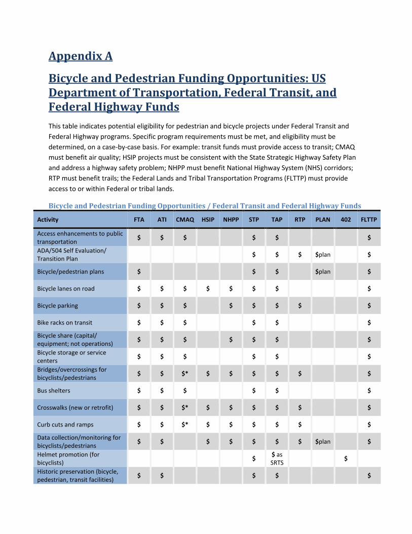
Appendix A
Bicycle and Pedestrian Funding Opportunities: US Department of Transportation, Federal Transit, and Federal Highway Funds This table indicates potential eligibility for pedestrian and bicycle projects under Federal Transit and Federal Highway programs. Specific program requirements must be met, and eligibility must be determined, on a case-by-case basis. For example: transit funds must provide access to transit; CMAQ must benefit air quality; HSIP projects must be consistent with the State Strategic Highway Safety Plan and address a highway safety problem; NHPP must benefit National Highway System (NHS) corridors; RTP must benefit trails; the Federal Lands and Tribal Transportation Programs (FLTTP) must provide access to or within Federal or tribal lands.
Bicycle and Pedestrian Funding Opportunities / Federal Transit and Federal Highway Funds
Activity FTA ATI CMAQ HSIP NHPP STP TAP RTP PLAN 402 FLTTP
Access enhancements to public transportation $ $ $ $ $ $
ADA/504 Self Evaluation/ Transition Plan $ $ $ $plan $
Bicycle/pedestrian plans $ $ $ $plan $
Bicycle lanes on road $ $ $ $ $ $ $ $
Bicycle parking $ $ $ $ $ $ $ $
Bike racks on transit $ $ $ $ $ $
Bicycle share (capital/ equipment; not operations) $ $ $ $ $ $ $
Bicycle storage or service centers $ $ $ $ $ $
Bridges/overcrossings for bicyclists/pedestrians $ $ $* $ $ $ $ $ $
Bus shelters $ $ $ $ $ $
Crosswalks (new or retrofit) $ $ $* $ $ $ $ $ $
Curb cuts and ramps $ $ $* $ $ $ $ $ $
Data collection/monitoring for bicyclists/pedestrians $ $ $ $ $ $ $ $plan $
Helmet promotion (for bicyclists) $ $ as
SRTS $ Historic preservation (bicycle, pedestrian, transit facilities) $ $ $ $ $
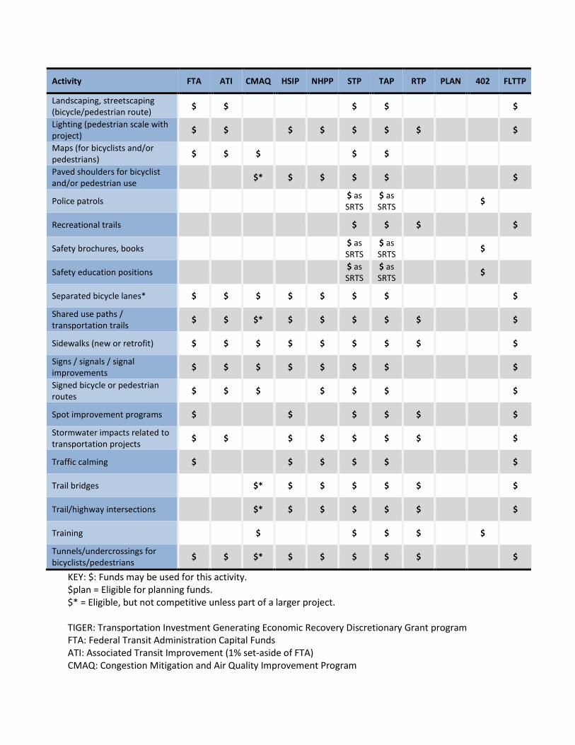
Activity FTA ATI CMAQ HSIP NHPP STP TAP RTP PLAN 402 FLTTP
Landscaping, streetscaping (bicycle/pedestrian route) $ $ $ $ $
Lighting (pedestrian scale with project) $ $ $ $ $ $ $ $
Maps (for bicyclists and/or pedestrians) $ $ $ $ $ Paved shoulders for bicyclist and/or pedestrian use $* $ $ $ $ $
Police patrols $ as SRTS
$ as SRTS $
Recreational trails $ $ $ $
Safety brochures, books $ as SRTS
$ as SRTS $
Safety education positions $ as SRTS
$ as SRTS $
Separated bicycle lanes* $ $ $ $ $ $ $ $
Shared use paths / transportation trails $ $ $* $ $ $ $ $ $
Sidewalks (new or retrofit) $ $ $ $ $ $ $ $ $
Signs / signals / signal improvements $ $ $ $ $ $ $ $
Signed bicycle or pedestrian routes $ $ $ $ $ $ $
Spot improvement programs $ $ $ $ $ $
Stormwater impacts related to transportation projects $ $ $ $ $ $ $ $
Traffic calming $ $ $ $ $ $
Trail bridges $* $ $ $ $ $ $
Trail/highway intersections $* $ $ $ $ $ $
Training $ $ $ $ $ Tunnels/undercrossings for bicyclists/pedestrians $ $ $* $ $ $ $ $ $
KEY: $: Funds may be used for this activity. $plan = Eligible for planning funds. $* = Eligible, but not competitive unless part of a larger project. TIGER: Transportation Investment Generating Economic Recovery Discretionary Grant program FTA: Federal Transit Administration Capital Funds ATI: Associated Transit Improvement (1% set-aside of FTA) CMAQ: Congestion Mitigation and Air Quality Improvement Program
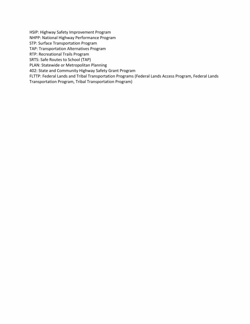
HSIP: Highway Safety Improvement Program NHPP: National Highway Performance Program STP: Surface Transportation Program TAP: Transportation Alternatives Program RTP: Recreational Trails Program SRTS: Safe Routes to School (TAP) PLAN: Statewide or Metropolitan Planning 402: State and Community Highway Safety Grant Program FLTTP: Federal Lands and Tribal Transportation Programs (Federal Lands Access Program, Federal Lands Transportation Program, Tribal Transportation Program)
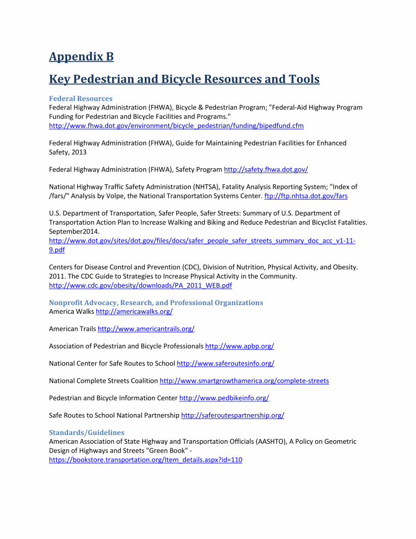
Appendix B
Key Pedestrian and Bicycle Resources and Tools Federal Resources Federal Highway Administration (FHWA), Bicycle & Pedestrian Program; "Federal-Aid Highway Program Funding for Pedestrian and Bicycle Facilities and Programs." http://www.fhwa.dot.gov/environment/bicycle_pedestrian/funding/bipedfund.cfm
Federal Highway Administration (FHWA), Guide for Maintaining Pedestrian Facilities for Enhanced Safety, 2013
Federal Highway Administration (FHWA), Safety Program http://safety.fhwa.dot.gov/
National Highway Traffic Safety Administration (NHTSA), Fatality Analysis Reporting System; "Index of /fars/" Analysis by Volpe, the National Transportation Systems Center. ftp://ftp.nhtsa.dot.gov/fars
U.S. Department of Transportation, Safer People, Safer Streets: Summary of U.S. Department of Transportation Action Plan to Increase Walking and Biking and Reduce Pedestrian and Bicyclist Fatalities. September2014. http://www.dot.gov/sites/dot.gov/files/docs/safer_people_safer_streets_summary_doc_acc_v1-11-9.pdf
Centers for Disease Control and Prevention (CDC), Division of Nutrition, Physical Activity, and Obesity. 2011. The CDC Guide to Strategies to Increase Physical Activity in the Community. http://www.cdc.gov/obesity/downloads/PA_2011_WEB.pdf
Nonprofit Advocacy, Research, and Professional Organizations America Walks http://americawalks.org/
American Trails http://www.americantrails.org/
Association of Pedestrian and Bicycle Professionals http://www.apbp.org/
National Center for Safe Routes to School http://www.saferoutesinfo.org/
National Complete Streets Coalition http://www.smartgrowthamerica.org/complete-streets
Pedestrian and Bicycle Information Center http://www.pedbikeinfo.org/
Safe Routes to School National Partnership http://saferoutespartnership.org/
Standards/Guidelines American Association of State Highway and Transportation Officials (AASHTO), A Policy on Geometric Design of Highways and Streets "Green Book" - https://bookstore.transportation.org/Item_details.aspx?id=110
American Association of State Highway and Transportation Officials (AASHTO),Guide for Achieving Flexibility in Highway Design - https://bookstore.transportation.org/item_details.aspx?ID=103
American Association of State Highway and Transportation Officials (AASHTO),Guide for the Development of Bicycle Facilities - http://safety.fhwa.dot.gov/ped_bike/docs/b_aashtobik.pdf
American Planning association (APA), Complete Streets: Best Policy and Implementation Practices - http://www.planning.org/apastore/search/Default.aspx?p=4060
Institute of Transportation Engineers (ITE), Context Sensitive Solutions in Designing Major Urban Thoroughfares for Walkable Communities - http://www.ite.org/bookstore/RP036.pdf
Institute of Transportation Engineers (ITE), Road Diet Handbook: Setting Trends for Livable Streets - http://www.ite.org/emodules/scriptcontent/Orders/ProductDetail.cfm?pc=LP-670
Manual on Uniform Traffic Control Devices (MUTCD) - http://mutcd.fhwa.dot.gov/kno_2009.htm
National Association of City Transportation Officials (NACTO), Urban Bikeways Design Guide - http://nacto.org/cities-for-cycling/design-guide/
Safety Resources BIKESAFE: Bicycle Countermeasure Selection System - http://www.bicyclinginfo.org/bikesafe/
Federal Highway Administration (FHWA), Pedestrian RSA Guidelines and Prompt Lists (Publication FHWA-SA-07-007) - http://katana.hsrc.unc.edu/cms/downloads/PedRSA.reduced.pdf
Federal Highway Administration (FHWA), Road Safety Audit Guidelines (Publication FHWA-SA-06-06) - http://safety.fhwa.dot.gov/rsa/guidelines/documents/FHWA_SA_06_06.pdf
Federal Highway Administration (FHWA), Road Safety Audit Web Site - http://safety.fhwa.dot.gov/rsa/
National Cooperative Highway Research Program (NCHRP) Report 500 Volume 18: A Guide for Reducing Collisions Involving Bicycles - http://onlinepubs.trb.org/onlinepubs/nchrp/nchrp_rpt_500v18.pdf
Orlando Area Bicyclist Crash Study: A Role-Based Approach to Crash Countermeasures (2004) - http://www.docstoc.com/docs/3785626/Orlando-Area-Bicyclist-Crash-Study-A-Role-Based-Approach-to
Smart Cycling: Traffic Skills 101 (League of American Bicyclists) - http://www.bikeleague.org/programs/education/courses.php#101
The Dilemmas of Bicycle Planning (Bicycle Driving) - http://bicycledriving.org/about/the-dilemmas-of-bicycle-planning
Tools Bicycle Countermeasure Selection System (BIKESAFE) http://www.pedbikesafe.org/BIKESAFE/
Bicycle Level of Service (BLOS) tool and guidelines - http://www.bikelib.org/roads/blos/blosform.htm
Pedestrian and Bicycle Crash Analysis Tool (PBCAT) http://www.walkinginfo.org/facts/pbcat/
Pedestrian and Bicycle Intersection Safety Indices (Ped and Bike ISI) - http://www.fhwa.dot.gov/publications/research/safety/pedbike/06130/06130.pdf
Pedestrian Safety Guide and Countermeasure Selection System (PEDSAFE) http://www.pedbikesafe.org/PEDSAFE/
Research Reports National Cooperative Highway Research Program (NCHRP) Report 616: Multimodal Level of Service Analysis for Urban Streets (2008) - http://onlinepubs.trb.org/onlinepubs/nchrp/nchrp_rpt_616.pdf
Alliance for Biking and Walking (2014). Bicycling and Walking in the United States: 2014 Benchmarking Report. https://www.bikewalkalliance.org/resources/benchmarking/
Frey, William H. The Brookings Institution. "Demographic Reversal: Cities Thrive, Suburbs Sputter." June 29, 2012. http://www.brookings.edu/research/opinions/2012/06/29-cities-suburbs-frey
Transit Cooperative Research Program and National Highway Cooperative Research Program, TCRP Report 112/ NCHRP Report 562, Improving Pedestrian Safety at Unsignalized Crossings. Kay Fitzpatrick, et al., 2006. http://trb.org/news/blurb_detail.asp?id=6630
McKenzie, Brian. Bureau of the Census, 2014, Modes Less Traveled: Bicycling and Walking to Work in the United States 2008-2012. May. http://www.census.gov/prod/2014pubs/acs-25.pdf
Milne, Andrea, and Maggie Melin. Alliance for Biking & Walking, Bicycling and Walking in the United States: 2014 Benchmarking Report. https://www.bikewalkalliance.org/storage/documents/reports/2014BenchmarkingReport.pdf
TransitCenter, Who's On Board 2014: Mobility Attitudes Survey, 2014. http://transitcenter.org/wp-content/uploads/2014/08/WhosOnBoard2014-ForWeb.pdf
National Cooperative Highway Research Program (NCHRP) Report 500 Vol. 18, Guidance for Implementation of the AASTO Strategic Highway Plan: A Guide for Reducing Collisions Involving Bicycles. http://www.trb.org/Publications/Public/Blurbs/A_Guide_for_Reducing_Collisions_Involving_Bicycles_156839.aspx
NCHRP Report 500 Vol. 20, Guidance for Implementation of the AASHTO Strategic Highway Plan: A Guide for Reducing Collisions Involving Pedestrians. http://www.trb.org/Publications/Public/Blurbs/A_Guide_for_Reducing_Collisions_Involving_Pedestri_154863.aspx
Transit Cooperative Research Program (TCRP) Report 95: Traveler Response to Transportation System Changes Handbook, Third Edition; Chapter 16, Pedestrian and Bicycle Facilities. http://www.trb.org/Publications/Blurbs/167122.aspx
University of North Carolina Highway Safety Research Center, Cost for Pedestrian and Bicyclist Infrastructure Improvements (2013). http://www.pedbikeinfo.org/data/library/details.cfm?id=4876/

Report prepared by:
Wyoming FHWA Division Office
2617 E. Lincolnway, Suite D
Cheyenne, WY 82001
(307)-772-2101