Citing and understanding spatial references for eResearch: Spatial Identifier Reference Framework...
24
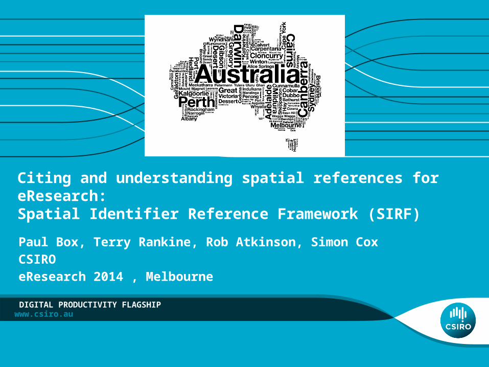
www.csiro.au Citing and understanding spatial references for eResearch: Spatial Identifier Reference Framework (SIRF) Paul Box, Terry Rankine, Rob Atkinson, Simon Cox CSIRO eResearch 2014 , Melbourne DIGITAL PRODUCTIVITY FLAGSHIP
Transcript of Citing and understanding spatial references for eResearch: Spatial Identifier Reference Framework...
www.csiro.au
Citing and understanding spatial references for eResearch: Spatial Identifier Reference Framework (SIRF)Paul Box, Terry Rankine, Rob Atkinson, Simon CoxCSIROeResearch 2014 , Melbourne
DIGITAL PRODUCTIVITY FLAGSHIP

Understanding and citing spatial references - SIRF | Paul Box
Understanding and citing spatial identifiers
• Spatial identifiers – nature and use• Current challenges & future directions• Spatial Identifiers Reference Framework - SIRF
2 |
Understanding and citing spatial references - SIRF | Paul Box
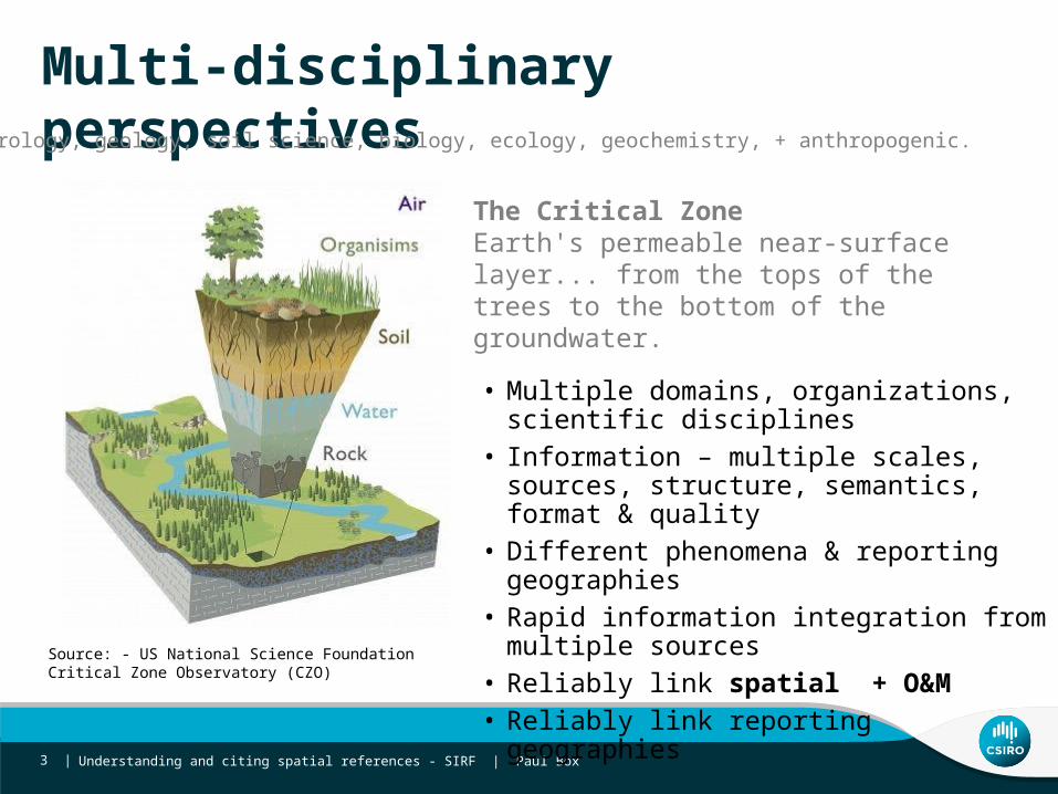
Multi-disciplinary perspectives
3 |
The Critical ZoneEarth's permeable near-surface layer... from the tops of the trees to the bottom of the groundwater.
Hydrology, geology, soil science, biology, ecology, geochemistry, + anthropogenic.
Source: - US National Science Foundation Critical Zone Observatory (CZO)
• Multiple domains, organizations, scientific disciplines
• Information – multiple scales, sources, structure, semantics, format & quality
• Different phenomena & reporting geographies• Rapid information integration from multiple
sources • Reliably link spatial + O&M• Reliably link reporting geographies

The present - information silos
System 1
System 2
System 3
System 5 System
4
System n
System 7
$$
$$$
$ $
Discover Access Understand Extract, Transform, Load
Use
Time and effort
Everything Happens Somewhere
Understanding and citing spatial references - SIRF | Paul Box 4 |
Gazetteer?

• Subjective constructs of geography - e.g. Gazetteer, local government areas, catchment management authority area, ground water management unit
• Layer & feature based approach • Identity (name, code) • Type• Geometry • Topology
• Independent spatial layers + metadata in catalogues (SDI)
Representing location - spatial data
Concept
Relationship
Understanding and citing spatial references - SIRF | Paul Box 5 |

Key issues Dataset • Identity is ambiguous • Topology & geometry conflated
SDI• Duplication - multiple representations• Disconnection – spatial layers disconnected from:
• each other • from other information• Discovery - many catalogues, poor metadata @ dataset level • Change
Understanding and citing spatial references - SIRF | Paul Box 6 |

Understanding and citing spatial references - SIRF | Paul Box
Identity
7 |

What’s in a name?
Official Country name lists• United Nations Statistics Division Country and
Region Codes for Statistical Use• United Nations Group of Experts on Geographic
Names - List of Country Names• Department for General Assembly and Conference
Management - Multilingual Terminology Database (UNTERM)
• ISO - ISO 3166: Codes for country names • UN FAO - Global Administrative Unit Layers (GAUL)
Figure 1: Variation rates in spelling for country names between the UN Statistical Division’s Country and Region Codes for Statistical Use and UN datasets from data.un.org
• One place - many names• Australia, Australie, أستراليا• Sydney, Syd, City of Sydney
• One name – many places
Understanding and citing spatial references - SIRF | Paul Box 8 |

One name – many places
Understanding and citing spatial references - SIRF | Paul Box 9 |
‘Leichhardt’
Leichhardt in Australia4 (52) Australian Gazetteer (GA) - NSW, QLD10 (12) ASGS (ABS) - NSW, VIC, QLD
Leichhardt in NSW3 (9) in NSW Place Names search (GNB NSW)
Leichhardt (Sub) NSW
Feature types• National Gazetteer• Suburb • Parish • Homestead
•ASGS • SA2 (NSW, QLD)• SA3 (NSW)• CED (QLD)• IARE (NSW) • State Suburb (VIC, NSW & QLD)• Gazetted locality
•GNB• County • Parish• Suburb (No LGA!)
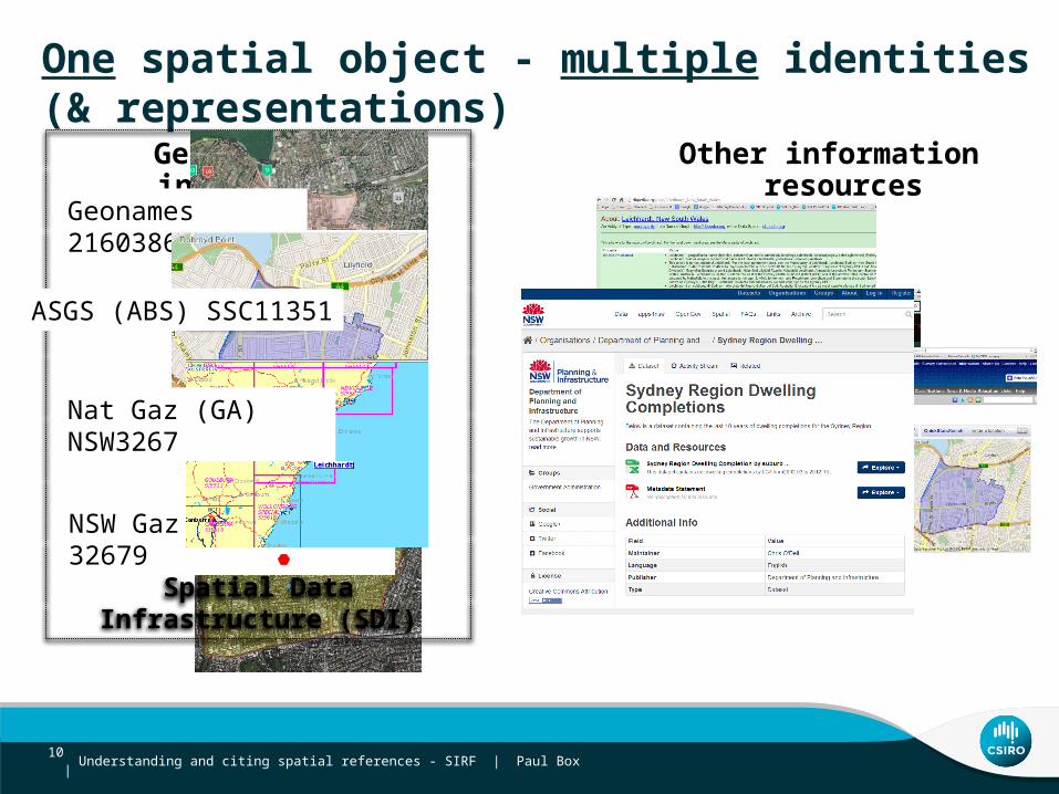
One spatial object - multiple identities (& representations)
Geospatial information Other information resources
NSW Gaz (GNB NSW) 32679
Spatial Data Infrastructure (SDI)
Understanding and citing spatial references - SIRF | Paul Box 10 |
Geonames 2160386
ASGS (ABS) SSC11351
Nat Gaz (GA) NSW3267

Understanding and citing spatial references - SIRF | Paul Box
Identifiers in spatial data
• Ambiguous • system scoped and non-unique• multiple identifiers for same spatial object• Unstable – not well managed change over time• Not well governed
11 |
Geometry & topology
Understanding and citing spatial references - SIRF | Paul Box 12 |

Separating geometry and topology
• Geometry used to encode topology• Geometry used for visualization, analysis• Most use cases need topology not geometry:
• Which Jurisdictions contains Leichhardt LGA• Which rivers are upstream of the Hawkesbury? • Geometry is – unreliable, inefficient for representing topology
Understanding and citing spatial references - SIRF | Paul Box 13 |
LGA boundaries & State boundaries
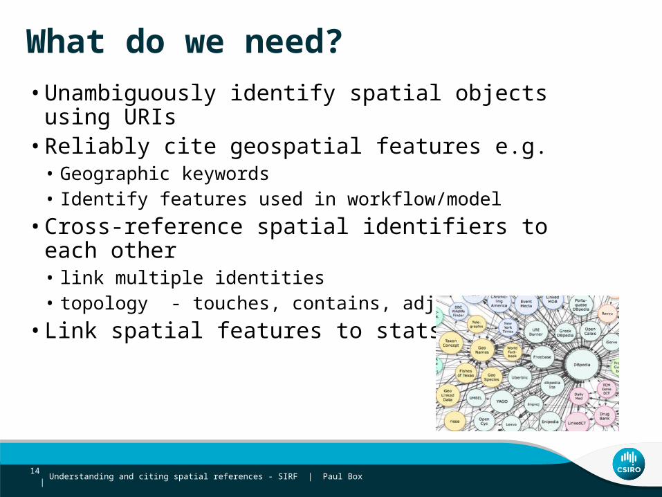
What do we need?• Unambiguously identify spatial objects using URIs• Reliably cite geospatial features e.g.
• Geographic keywords • Identify features used in workflow/model• Cross-reference spatial identifiers to each other
• link multiple identities• topology - touches, contains, adjacent • Link spatial features to stats/obs
Understanding and citing spatial references - SIRF | Paul Box 14 |

Understanding and citing spatial references - SIRF | Paul Box
Spatial Identifier Reference Framework - spatial linked data enabling of SDI
15 |

Geospatial information Statistical information (Implicitly geospatial)
GNB NSW 32679
Spatial Data Infrastructure (SDI)
Understanding and citing spatial references - SIRF | Paul Box 16 |
Geonames 2160386
ABS ASGS SSC11351
GA Aus Gaz NSW3267
Linked spatial data to bridge existing gaps
Spatial IdentifierReference Framework
Index Crosswalk Explore
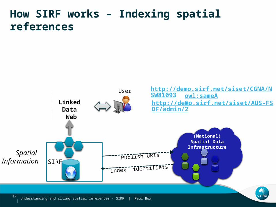
How SIRF works – Indexing spatial references
SIRFSpatial
Information
User
Linked Data Web
Index identifiers
http://demo.sirf.net/siset/CGNA/NSW81093
http://demo.sirf.net/siset/AUS-FSDF/admin/2
Publish URIs
Understanding and citing spatial references - SIRF | Paul Box 17 |
(National) Spatial Data Infrastructure
owl:sameAs

Understanding and citing spatial references - SIRF | Paul Box 18 |

Understanding and citing spatial references - SIRF | Paul Box
LinksetLinksetSISetSISet SISetSISet
Relationships between spatial objects
Australian National Gazetteer
FSDF Admin Boundary
‘Cross-walks’ between SISets
• Centralise the problem• Machine + manual processing• Demand driven• Cross-walks treated as first class citizens• Well managed and shareable
19 |

Understanding and citing spatial references - SIRF | Paul Box
http://id.sirf.net/siset/SA_SUBURBS/501001- SA suburb - SA gazetteer- National gazetteer
SIRF data network
20 |

SIRF - linking between productsANZ Foundation Spatial Data Framework
Understanding and citing spatial references - SIRF | Paul Box 21 |
OWL SameAs
NSW
Albury(LGA)
TowongLGA
VICGeo:sf-adjacent
Geo:sf-contains
Geo:sf-contains
Geo:sf-adjacent
Geo:sf-contains
FSDF Admin Boundary Product
Leichhardt (LGA)
S. Metro Region
Albert Park District
Geo:sf-contains
Geo:sf-contains
FSDF Place Name Product
Geo:sf-contains
NSW
Geo:sf-contains
Leichhardt
LambertPark Geo:sf-contains
OWL SameAs
Cross-walks registered in SIRF
Data set indexed in SIRF
Data set indexed in SIRF
Understanding and citing spatial references - SIRF | Paul Box
Identifier patterns
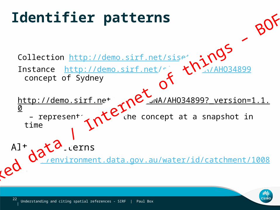
Collection http://demo.sirf.net/siset/CGNA/Instance http://demo.sirf.net/siset/CGNA/AHO34899 concept of Sydney
http://demo.sirf.net/siset/CGNA/AHO34899?_version=1.1.0 – representation of the concept at a snapshot in time
Alt ID patternshttp://environment.data.gov.au/water/id/catchment/100862
22 |
Linked data / Internet of th
ings – BOF

Key messages
• Different to Wikipedia/Geonames • NOT creating a new unauthoritative dataset • Building set of indexes to underlying authoritative spatial data -
with provenance - source metadata• Reliable unambiguous URI to reference to spatial object (concept
or representation) • Linked data to express identity of and linkage between spatial
objects• Bridge between native GIS representations and other data across
the web• URIs – pattern and content governance
Understanding and citing spatial references - SIRF | Paul Box 23 |

Paul Box
t: +61 2 93253122e: [email protected]: www.csiro.au
DIGITAL PRODUCTIVITY FLAGSHIP
Thank youCSIRO Digital Productivity Flagship
SIRF OpenSearch http://unsdi.csiro.au/UNSDIOpenSearch/searchSIRF API doco http://www.sirf.net