Choctawhatchee Bay - U.S. Geological Survey · PDF fileChoctawhatchee Bay is more than 43 km...
11
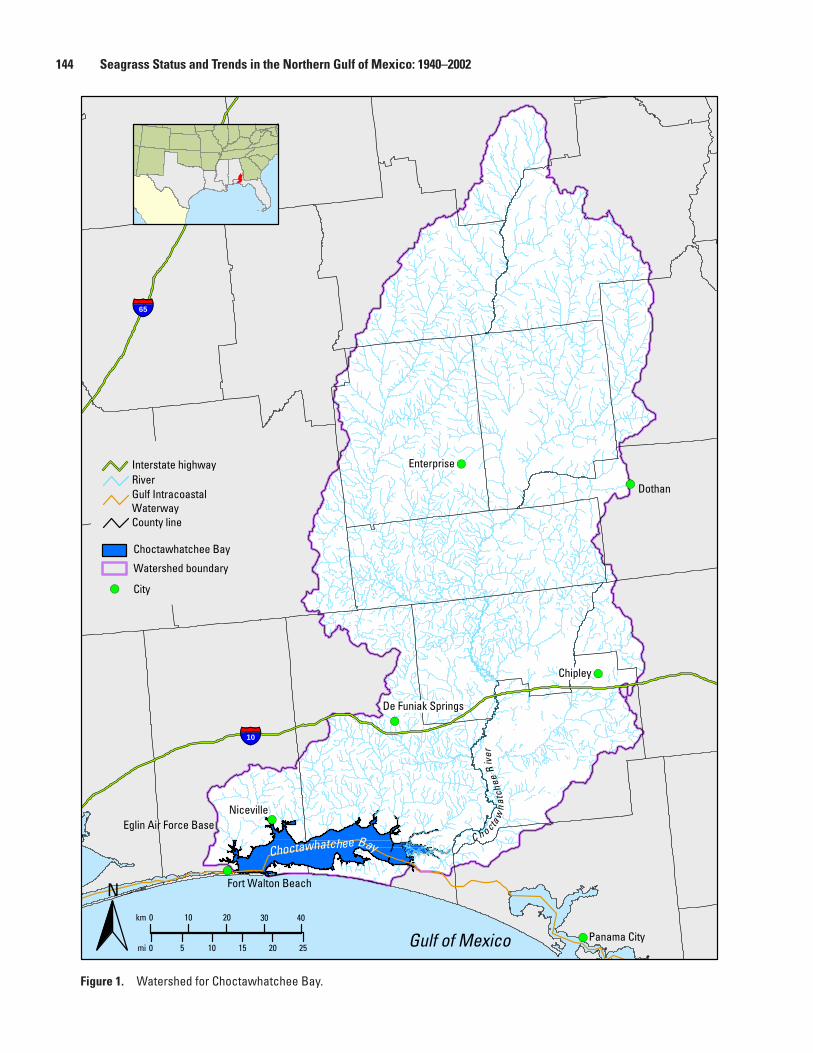
Choctawhatchee Bay By Barbara Ruth 1 and Lawrence R. Handley 2 1 Florida Department of Environmental Protection, Northwest District. 2 U.S. Geological Survey. Background The Choctawhatchee River and Bay system historically has supported a rich and diverse ecology that provides substantial economic and quality-of-life benefits to residents of northwest Florida (Northwest Florida Water Management District, 1996). The Choctawhatchee Bay area has become a highly desired area for relocation for many people: the perceived overdevelopment in southern Florida has led many to look for less highly developed areas. Although the area has no major industry, urban and suburban development, along with businesses that support Eglin Air Force Base (AFB) activities and an extensive retirement community, is creating impacts on the ecosystem through additional stormwater runoff, resource utilization, and similar pressures that are caused by development. In addition, as population along the bay’s shoreline has increased, the number of seawalls and docks has also increased, reducing the intertidal areas that protect the bay’s seagrass resources. The Choctawhatchee Bay watershed encompasses nearly 13,856 km 2 (5,350 mi 2 ) and spans portions of northwest Florida and southern Alabama (fig. 1). Much of the watershed is composed of agricultural, silvicultural, and rural land, with a large portion of the Florida part of the watershed also making up the lands of Eglin AFB. Historically, northwest Florida has been primarily an agricultural area, as is the case with the Choctawhatchee Bay watershed. Prior to the acquisition of lands for Eglin AFB in the early 1900s, the area was heavily timbered, causing major system alterations including extensive dirt road building, overharvest of longleaf pine (Pinus palustris), and conversion of lands to other uses. Northwest Florida still contains more than 50% of the remaining old-growth stands of longleaf pine, however, and is widely recognized as a nationally significant reservoir of rare biota (Feller and others, 1997). The bay is supplied with fresh water from the Choctawhatchee River and several creeks and springs and with ground water from the Floridan aquifer system (Northwest Florida Water Management District, 1996). The only direct opening to the Gulf of Mexico is through the relatively shallow East Pass (immediately west of Destin), an artificial channel opened in 1929 to provide a permanent pass through a previously intermittent opening. The bay also opens to the Gulf Intracoastal Waterway (GIWW) in the east and to Santa Rosa Sound and the GIWW in the west. (The GIWW is regularly maintained by the U.S. Army Corps of Engineers.) Pensacola Pass is separated from the west side of the bay by an 84-km (52-mi) portion of the GIWW that was dredged initially in the 1940s (Northwest Florida Water Management District, 1996). Choctawhatchee Bay is a stratified system with low tidal energy, limited flushing (Blaylock, 1983; Livingston, 1986), and a halocline (noticeable changes in salt concentrations between the surface waters and lower waters) (Blaylock, 1983; Livingston, 1986). The bay’s main freshwater influence is the Choctawhatchee River, which has a rate of 243 m 3 /s (8,580 ft 3 /s) (Northwest Florida Water Management District, 1996) annual average discharge. With the freshwater influence accompanied by the influx of salt water from the Gulf of Mexico, the bay’s salinity level is constantly fluctuating. The seagrass beds in Choctawhatchee Bay are considered extremely important because they support diverse populations of fish and invertebrates, including many recreational and commercial species (Northwest Florida Water Management District, 1996). Commercial and sport fisheries are important in the area, as is oyster harvesting. Significant portions of Choctawhatchee Bay are designated as Class II waters of the State (designated for shellfish propagation or harvesting). Commercially and recreationally important fish and shellfish include shrimp (Penaeus spp.), eastern oysters (Crassostrea virginica), spotted seatrout (Cynoscion nebulosus), gulf menhaden (Brevoortia patronus), red drum or redfish (Sciaenops ocellatus), blue crab (Callinectes sapidus), gulf flounder (Paralichthys albigutta), striped mullet (Mugil cephalus), and white mullet (Mugil curema). In addition, the bay system includes endangered species including the gulf sturgeon (Acipenser oxyrinchus), which migrates through the bay into the Choctawhatchee River to spawn. The easternmost part of the bay and the river delta, as well as the Rocky Bayou State Park Aquatic Preserve, are designated by the Environmental Regulation Commission of the Florida Department of Environmental Protection as Outstanding Florida Waters (chapter 62-302.700, Florida Administrative Code), worthy of special protection because of their natural attributes.
-
Upload
truongcong -
Category
Documents
-
view
215 -
download
2
Transcript of Choctawhatchee Bay - U.S. Geological Survey · PDF fileChoctawhatchee Bay is more than 43 km...
Choctawhatchee Bay
By Barbara Ruth1 and Lawrence R. Handley 2
1 Florida Department of Environmental Protection, Northwest District.
2 U.S. Geological Survey.
BackgroundThe Choctawhatchee River and Bay system historically
has supported a rich and diverse ecology that provides substantial economic and quality-of-life benefits to residents of northwest Florida (Northwest Florida Water Management District, 1996). The Choctawhatchee Bay area has become a highly desired area for relocation for many people: the perceived overdevelopment in southern Florida has led many to look for less highly developed areas. Although the area has no major industry, urban and suburban development, along with businesses that support Eglin Air Force Base (AFB) activities and an extensive retirement community, is creating impacts on the ecosystem through additional stormwater runoff, resource utilization, and similar pressures that are caused by development. In addition, as population along the bay’s shoreline has increased, the number of seawalls and docks has also increased, reducing the intertidal areas that protect the bay’s seagrass resources.
The Choctawhatchee Bay watershed encompasses nearly 13,856 km2 (5,350 mi2) and spans portions of northwest Florida and southern Alabama (fig. 1). Much of the watershed is composed of agricultural, silvicultural, and rural land, with a large portion of the Florida part of the watershed also making up the lands of Eglin AFB.
Historically, northwest Florida has been primarily an agricultural area, as is the case with the Choctawhatchee Bay watershed. Prior to the acquisition of lands for Eglin AFB in the early 1900s, the area was heavily timbered, causing major system alterations including extensive dirt road building, overharvest of longleaf pine (Pinus palustris), and conversion of lands to other uses. Northwest Florida still contains more than 50% of the remaining old-growth stands of longleaf pine, however, and is widely recognized as a nationally significant reservoir of rare biota (Feller and others, 1997).
The bay is supplied with fresh water from the Choctawhatchee River and several creeks and springs and with ground water from the Floridan aquifer system (Northwest Florida Water Management District, 1996). The only direct opening to the Gulf of Mexico is through the relatively shallow East Pass (immediately west of Destin), an artificial
channel opened in 1929 to provide a permanent pass through a previously intermittent opening. The bay also opens to the Gulf Intracoastal Waterway (GIWW) in the east and to Santa Rosa Sound and the GIWW in the west. (The GIWW is regularly maintained by the U.S. Army Corps of Engineers.) Pensacola Pass is separated from the west side of the bay by an 84-km (52-mi) portion of the GIWW that was dredged initially in the 1940s (Northwest Florida Water Management District, 1996). Choctawhatchee Bay is a stratified system with low tidal energy, limited flushing (Blaylock, 1983; Livingston, 1986), and a halocline (noticeable changes in salt concentrations between the surface waters and lower waters) (Blaylock, 1983; Livingston, 1986). The bay’s main freshwater influence is the Choctawhatchee River, which has a rate of 243 m3/s (8,580 ft3/s) (Northwest Florida Water Management District, 1996) annual average discharge. With the freshwater influence accompanied by the influx of salt water from the Gulf of Mexico, the bay’s salinity level is constantly fluctuating.
The seagrass beds in Choctawhatchee Bay are considered extremely important because they support diverse populations of fish and invertebrates, including many recreational and commercial species (Northwest Florida Water Management District, 1996). Commercial and sport fisheries are important in the area, as is oyster harvesting. Significant portions of Choctawhatchee Bay are designated as Class II waters of the State (designated for shellfish propagation or harvesting). Commercially and recreationally important fish and shellfish include shrimp (Penaeus spp.), eastern oysters (Crassostrea virginica), spotted seatrout (Cynoscion nebulosus), gulf menhaden (Brevoortia patronus), red drum or redfish (Sciaenops ocellatus), blue crab (Callinectes sapidus), gulf flounder (Paralichthys albigutta), striped mullet (Mugil cephalus), and white mullet (Mugil curema). In addition, the bay system includes endangered species including the gulf sturgeon (Acipenser oxyrinchus), which migrates through the bay into the Choctawhatchee River to spawn. The easternmost part of the bay and the river delta, as well as the Rocky Bayou State Park Aquatic Preserve, are designated by the Environmental Regulation Commission of the Florida Department of Environmental Protection as Outstanding Florida Waters (chapter 62-302.700, Florida Administrative Code), worthy of special protection because of their natural attributes.
10
65
C h octaw
hat
chee
Riv
er
Fort Walton Beach
Niceville
Panama City
De Funiak Springs
Chipley
Enterprise
Dothan
Eglin Air Force Base
Gulf of Mexico40 30 20 10 0 km
20 25 15 10 5 0 mi
N
Choctawhatchee Bay
Watershed boundary
City
Interstate highway River Gulf Intracoastal Waterway County line
Choctawhatchee Bay
Figure 1. Watershed for Choctawhatchee Bay.
144 Seagrass Status and Trends in the Northern Gulf of Mexico: 1940–2002

As in much of northwest Florida in the 1990s, the Choctawhatchee Bay watershed is experiencing rapid development, particularly along the eastern and southern shores. Numerous hotels and condominiums are being constructed along the perimeter of the bay. The human population of the watershed is growing rapidly, with that of the Florida counties increasing 41% from 1980 to 1995 (Northwest Florida Water Management District, 1996). Changes in population recorded between the 1990 and 2000 censuses show an increase of approximately 28% for the Choctawhatchee Bay area compared to 23% for Florida overall and 13% for the United States as a whole. Increased development threatens the water quality of the bay through increases in impervious surfaces that reduce water filtration as well as nutrient and other pollutant additions. Development in the northern portion of the bay is less intensive because Eglin AFB occupies much of the northern drainage area.
Baseline studies conducted in 1980 identified important resources and productive areas along with potential problem areas. Potential human impacts in problem areas included urban development, stormwater runoff, causeway construction, marina development, overfishing, riverborne agricultural pesticides and fertilizers, and military activities (Livingston, 1986). Natural events impacting the bay system included major storms, such as hurricanes and tropical storms, as well as drought periods, such as the 3-yr drought that northwest Florida experienced from 1999 through 2001.
There were 13 major floods in the Choctawhatchee River in the 20th century, including 2 in the 1990s (Northwest Florida Water Management District, 1996). The flood of 1929 reportedly created the inlet at East Pass. Local residents dug a trench where an intermittent stream connected with the Gulf of Mexico to help relieve the swelled bay. The U.S. Army Corps of Engineers has maintained the pass since Congress approved maintenance of it in 1930. Tropical Storm Alberto (1994) caused extreme flooding in the Choctawhatchee Bay watershed, providing inputs of large amounts of fresh water, sediments, and nutrients to Choctawhatchee Bay. Hurricane Opal (1995), a category 3 hurricane, came ashore just east of Fort Walton Beach on the western edge of the bay and caused significant damage to the area, including washing large amounts of sand into the southern portion of the bay. In 1999 the area began experiencing a drought that resulted in rainfall amounts 25–38 cm (10–15 inches) below annual averages. Drought conditions continued through summer 2002. The lack of rainfall reduced stormwater runoff, providing less nutrient and sediment loading to the system. Salinity levels increased because less fresh water entered the bay through the Choctawhatchee River and local creeks.
Scope of AreaChoctawhatchee Bay is more than 43 km (27 mi) long
and follows an east-west orientation along the upper gulf coast of Florida in Okaloosa and Walton Counties. It varies from 2 to 10 km (1 to 6 mi) in width, with depths ranging from 3 to 13 m (10 to 43 ft). The bay has four basic natural habitats: shallow slope areas (vegetated, unvegetated, and oyster beds), deep central basin regions (unvegetated), bayous, and a river delta area, with East Pass connecting the bay to the Gulf of Mexico. Tidal exchange in the bay is minimal (a range of about 0.15 m, or 0.5 ft), and flushing is limited to the narrow, shallow opening to the Gulf of Mexico at East Pass.
The bay receives most of its freshwater inflow from Choctawhatchee River, which receives flow from several tributaries including Pea River, Wrights Creek, Sandy Creek, Pine Log Creek, Seven Runs, Holmes Creek, and Bruce Creek. Several creeks feed the various bayous surrounding the bay, including Turkey Creek, Rocky Creek, Swift Creek, and Alaqua Creek. Freshwater sources also include groundwater contributions from springs and the Floridan aquifer. The Choctawhatchee Bay watershed has the highest elevations in Florida. Soft, sandy soil, intense rainfall, and steep topographical relief make this area highly susceptible to erosion, particularly after removal of vegetative cover, during road construction, and with agricultural activities. Human impacts, in concert with natural forces, can affect the health and distribution of seagrass beds.
The area covered in this report extends from the delta area in the east where the Choctawhatchee River enters the bay to the Brooks Bridge on U.S. Highway 98 in Fort Walton Beach in the west and includes the several bayous around the bay. For purposes of describing seagrass status in this report, Choctawhatchee Bay was divided into three segments: western, middle, and eastern (fig. 2).
Western Choctawhatchee Bay
Western Choctawhatchee Bay includes all areas west of the Hwy 293 Mid-Bay Bridge to Brooks Bridge (where Santa Rosa Sound begins), which is the more saline portion of the bay and includes deeper sections (maximum depth is 13 m, or 43 ft), and historically has been the most developed area. The towns of Fort Walton Beach, Niceville, Valparaiso, and Destin as well as the main activities area of Eglin AFB (runways, support facilities, etc.) surround this area. The western segment includes Cinco Bayou, Garnier Creek, and Weekley Bayou in the Fort Walton Beach area. In the Niceville
Scope of Area 145

1
2
3
Gulf
Intra
coas
tal W
ater
way
Segm
ent
1W
este
rn C
hoct
awha
tche
e Ba
y
3Ea
ster
n Ch
octa
wha
tche
e Ba
y
2M
iddl
e Ch
octa
wha
tche
e Ba
y
Stud
y a
rea
N
Florida
Gulf
of M
exic
o
Cho
ctaw
hatc
hee
Bay
Hog
tow
n Ba
you
Hor
sesh
oeB
ayou
Eglin Village
State Highway 293
Mid-Bay Brid
ge
Dons Bayou
Toms Creek
Garnier Bayou
Juniper Creek Tu
rkey C
reek
Destin
Okaloosa County
Walton County
Poin
tW
ashi
ngto
n
Choc
taw
hatc
hee
Rive
r
Rocky Creek
Basin Creek
LaGrange Bayou
Basin Bayou
Black Creek
Camp Creek
Ramsey Branch
Jolly Bay
State Road 331 bridge
Trout Creek
Mullet Creek
Eagle Creek
Rocky Bayou
La Grange PointFreeport
Fourmile Creek
Fort Walton
Beach
Lafayette Creek
Alaqua BayouAlaqua
Creek
Cinco Bayou Santa Rosa Island
Santa Rosa Sound
Broo
ksBr
idge
km mi
2
2
00
46
810
64
Figu
re 2
. Sc
ope
of a
rea
for t
he C
hoct
awha
tche
e Ba
y vi
gnet
te.
146 Seagrass Status and Trends in the Northern Gulf of Mexico: 1940–2002

and Valparaiso area, Turkey and Juniper Creeks enter Boggy Bayou, Toms Creek flows to Toms Bayou, and Rocky Creek enters Rocky Bayou, much of which is surrounded by a State park, the Rocky Bayou State Park Aquatic Preserve. These waterways all drain portions of Eglin AFB property through urbanized areas. The western section includes East Pass (with its limited tidal exchange), the connection to Santa Rosa Sound, and the western continuation of the GIWW.
Middle Choctawhatchee Bay
Middle Choctawhatchee Bay includes all areas of the bay between the State Road (SR) 331 bridge and the Mid-Bay Bridge. Much of the northern shore consists of Eglin AFB property. Mullet Creek, Trout Creek, the portion of Basin Creek to Basin Bayou, and the portion of Alaqua Creek to Alaqua Bayou, plus several smaller creeks, drain much of the Eglin Wildlife Management Area. East Branch Fourmile Creek and Lafayette Creek drain the Freeport area through LaGrange Bayou to the eastern portion of the middle bay. The southern shore includes Horseshoe and Hogtown Bayous and the resort area of Sandestin. Most of this section of the bay is classified as Class II, Shellfish Propagation or Harvesting, and contains the majority of the oyster resources in the bay.
Eastern Choctawhatchee Bay
Eastern Choctawhatchee Bay includes all areas of the bay east of the SR 331 bridge, which includes the Choctawhatchee River Delta area, the primary source of fresh water to the bay. The Choctawhatchee River is considered the fourth largest river in the State of Florida (Fernald and Purdum, 1998). River discharge dominates the circulation pattern of the bay (Northwest Florida Water Management District, 1996). The river provides approximately 90% of the total supply of fresh water to the bay system, and its inflows exert the greatest influence on average bay salinity (Eglin Air Force Base, 1996). In addition to the Florida ERC’s designation of the Choctawhatchee River as an Outstanding Florida Water, the eastern bay waters are classified as Class II, Shellfish Propagation or Harvesting. Water depth averages 3 m (10 ft) in the eastern portion of the bay. The GIWW for this portion of the bay continues to the east out of Choctawhatchee Bay, just south of the delta near Point Washington.
Methodology Employed To Determine and Document Current Status
The most current mapping study of seagrass coverage for the Choctawhatchee Bay area was conducted more than 10 yr ago by the U.S. Geological Survey (USGS) National Wetlands Research Center (NWRC) by using natural-color aerial
photography taken in 1992 at a 1:24,000 scale as part of the northeastern Gulf of Mexico seagrass mapping project.
The mapping protocol consisted of stereoscopic photointerpretation, cartographic transfer, and digitization in accordance with strict mapping standards and conventions. Other important aspects of the protocol include the development of a classification system, groundtruthing, quality control, and peer review.
The information derived from the photography was subsequently transferred by using a zoom transfer scope onto a stable medium overlaying USGS 1:24,000-scale quadrangle base maps. The primary data source was 1:24,000-scale natural color aerial photography flown by the National Aeronautics and Space Administration (NASA) Stennis Space Center in fall 1992. In those cases where the data were inadequate or incomplete, contemporary supplemental data were acquired from other sources and used to complete the photographic coverage.
The seagrass classification system that was developed consisted of two classes of open water—RIV (riverine, fresh water) and EST (estuarine or marine open water)—and five classes of seagrass habitats. One seagrass habitat class is continuous seagrass, CSG, for which no density distinction was made; the other four classes of patchy seagrass are based on percent ground cover of the patches in 5% increments: PSG1 (0%–10%, very sparse), PSG2 (15%–40%, sparse), PSG3 (45%–70%, moderate), and PSG4 (75%–95%, dense).
The groundtruthing phase included the participation of field staff from the Gulf Islands National Seashore, U.S. Fish and Wildlife Service, Dauphin Island Sea Lab, Mississippi State University, Alabama Department of Conservation and Natural Resources, and Florida Department of Environmental Protection. Draft maps were sent out to these agencies for review and comments. All comments received were incorporated into the final maps.
Methodology Employed To Analyze Historical Trends
Studies conducted in Choctawhatchee Bay to determine the status and trends of seagrass resources since 1949 have been limited and mostly were either part of a larger, general study (McNulty and others, 1972) or site-specific projects (U.S. Army Corps of Engineers, 1973, 1976) with limited documentation of methodologies employed.
Burch (1983) reviewed the earlier studies and different types of aerial photography furnished by the Florida Department of Transportation. Burch noted that the photography, besides being at different scales, did not cover the entire bay at any given time. Color aerial photography at a 1:24,000 scale from 1980 was used to delineate areas in the western portion of the bay, while photography taken from the NASA ER-2 aircraft at a 1:65,000 scale from 1979 was used for the remainder of the bay. Black and white aerial
Methodology Employed To Analyze Historical Trends 147

photography (1:20,000 scale from 1949 and 1955 and 1:40,000 scale from 1969) was used for historical comparisons. Field verification was conducted with transect sampling by using an Ekman dredge (Wildco®, Buffalo, N.Y.) and a “weed rake” similar to that used by the Florida Department of Natural Resources (now the Florida Department of Environmental Protection). North-south oriented transects 0.5 m (1.6 ft) apart were sampled from April to September 1982. Military restrictions limited field verifications in Rocky Bayou and from Boggy Bayou to White Point.
Status and Trends
Although the seagrass beds in Choctawhatchee Bay are considered extremely important, only limited studies have been conducted in Choctawhatchee Bay to determine the status and trends of those seagrass resources, and these studies have used different methods that make direct comparisons to current data difficult. Furthermore, these studies placed most of the seagrass beds in Choctawhatchee Bay in shallow nearshore areas, but seagrass has been found in water depths up to approximately 3 m (10 ft).
Burch (1983) summarized earlier studies, including those of McNulty and others (1972) and the U.S. Army Corps of Engineers (USACE) (1973, 1976). McNulty and others (1972) reported 1,237 ha (3,057 acres) of submerged aquatic vegetation in Choctawhatchee Bay as part of a larger study that covered the entire Gulf of Mexico coast (fig. 3). Mapping was done with limited field verification, and species were
not identified. The USACE studies were limited to specific projects in the eastern section of the bay.
Interpretation of aerial photographs by Burch (1983) indicated significant loss of seagrass beds for most areas in the bay between 1949 and 1985. Burch determined that the submerged aquatic vegetation was limited to two species, shoal grass (Halodule wrightii) and wigeon grass (Ruppia maritima). The author concluded that the bay has supported varying amounts of submerged aquatic vegetation, with declines evident in several locations since 1949, and noted that less decline was evident between 1972 and 1982, with vegetation areas at the time of the study similar in location and configuration to those mapped in 1972.
The USGS conducted an analysis from aerial photographs taken in 1992, differentiating between continuous or patchy seagrass areas (fig. 4). This analysis provided an estimate of 1,726 ha (4,265 acres) of seagrass present in the bay (table 1). These data show that seagrass communities within Choctawhatchee Bay occurred primarily in higher salinity waters of the western and middle bay (fig. 5).
Western Choctawhatchee Bay
Burch (1983) reported six major areas with significant populations of shoal grass in 1982, five of which were in the western bay area: Moreno Point to Joes Bayou, East Pass, Santa Rosa Sound entrance, Black Point, and White Point. The coverage of shoal grass ranged from 20% to 80%, but most areas had more than 40% coverage. Seagrass beds with less than 40% coverage were reported northwest of Destin, Smack Point, and Eglin Village.
Submerged aquatic vegetation
Fort Walton Beach
EastPass
Shalimar
BuccarooPoint
Moreno Point
FourmilePoint
CobbsPoint
PineyPoint
LiveoakPoint
WheelerPoint
StakePoint
WhitePoint
GrassyCove
Rocky Bayou
Boggy Bayou
Joes Bayou Indian
Bayou Horseshoe Bayou
Hogtown Bayou
Jolly Bay
LaGrange Bayou
Alaqua Bayou
Basin Bayou
Garnier Creek
Cinco Bayou
EagleCreekEglin AFB
Valparaiso
Niceville
Destin
Freeport
Santa Rosa Island
Western
Middle
Eastern
Gulf of Mexico
BlackPoint
N
Figure 3. Distribution of submerged aquatic vegetation in Choctawhatchee Bay, 1972.
148 Seagrass Status and Trends in the Northern Gulf of Mexico: 1940–2002

The USGS data show that most seagrass areas contained patchy beds (1,428 ha, or 3,529 acres) and were located primarily in the western bay, where 1,109 ha (2,740 acres) of patchy beds were delineated (table 1). Only 317 ha (783 acres) of continuous seagrass beds were present (table 1). The continuous seagrass beds were mainly located north of Santa Rosa Island, west of East Pass, in the area bordered on the south by the national seashore (fig. 4). The USGS analysis showed seagrass beds in areas similar to the 1972 data; however, the 1992 set showed patchy seagrass beds along the eastern shore of Fort Walton Beach, while the 1972 delineation does not indicate any seagrass in this area.
An extensive shoal grass bed that ranged in depth from less than 1 m (3 ft) to at least 3 m (10 ft) and extended offshore for more than 274 m (900 ft) was observed in the White Point area in 1991 (Donald Ray, Florida Department of Environmental Protection, written commun., 1991).
Livingston (1986) estimated 307 ha (759 acres) in the western portion of the bay and reported a loss of nearly 20% between 1955 and 1985.
Middle Choctawhatchee Bay
Hogtown Bayou in the south-central part of the bay was one of the major areas with significant populations of shoal grass in 1982 (Burch, 1983). Livingston (1986) reported wigeon grass mixed with shoal grass in Hogtown Bayou. Seagrass beds with less than 40% coverage were reported near Fourmile Point, east of the Okaloosa-Walton County line (Burch, 1983). Seagrass beds appeared to be more extensive in Hogtown Bayou in 1972 than in the later analysis in 1992 (figs. 3 and 4).
Eastern Choctawhatchee Bay
The USACE described wigeon grass occurring in the shallow, muddy areas of the bay at the LaGrange Bayou entrance in a 1973 environmental impacts study (U.S. Army Corps of Engineers, 1973). In a 1976 environmental impacts study, the USACE noted submerged grasses present near the mouth of the Choctawhatchee River in Bunker Cove and west of Point Washington but did not name which species were present (U.S. Army Corps of Engineers, 1976). Burch’s (1983) analysis of the 1972 aerial photography indicated that seagrass beds appeared to be more extensive in the eastern section of the bay than the 1992 data show (figs. 3 and 4).
Causes of ChangeBecause the Choctawhatchee Bay system consists
of three segments with diverse characteristics, only broad observations regarding change are possible. In addition, there is a lack of comparable historical information, as the available seagrass data were derived by different methods and for different areas within the bay. Because freshwater inflow and poor flushing heavily influence Choctawhatchee Bay, the bay exhibits extremes of fresh water, which are marine conditions that may contribute naturally to declines and expansions of seagrass beds. While it appears that the bay has supported varying amounts of seagrass in the last 50 yr, seagrass areas have declined in several locations since the 1950s.
The health of the bay and its seagrass beds is being threatened by increased development in the Choctawhatchee Bay watershed. Increasing numbers of people desire to be on or near the water, whether for living, recreation, or both. As environmentally attractive and sensitive lands are more heavily used, stress on the resources, including sensitive habitats such as seagrass beds, is increasing. This increased development also threatens the water quality of the bay through nutrient and other pollutant additions. The National Oceanic and Atmospheric Administration has described the bay as exhibiting strong symptoms of eutrophication, with seagrass loss being one of the secondary symptoms indicative of eutrophication (Bricker and others, 1999). Seagrass scarring has also been indicated as a problem in the bay (Sargent and others, 1995).
Western Choctawhatchee Bay
Older developed areas (Fort Walton Beach, Valparaiso, Niceville, and Eglin AFB main base and the earlier Destin development) border western Choctawhatchee Bay. During the 1970s, this area displayed eutrophication, extensive plankton “blooms,” seagrass bed die-off, and fish kills (Young and Butts, 1984). A study by Young and Butts (1984) attributed much of the earlier pollution to sewage treatment plants in the peripheral bayous and eastern Santa Rosa Sound but
Segment Classification Hectares Acres
Western Continuous 317 783
Patchy 1,109 2,739
Middle Continuous 0.4 1
Patchy 297 733
Eastern Patchy 2 5
Total Continuous 314 784
Patchy 1,408 3,477
Table 1. Choctawhatchee Bay seagrass status, 1992.
[Data source: U.S. Geological Survey photointerpretation of 1:24,000-scale natural color aerial photography flown by Stennis Space Center (National Aeronautics and Space Administration) in fall 1992]
Causes of Change 149

Gulf
of M
exic
o
02
46
8km
01
23
45
mi
N
Wat
erSe
agra
ss, p
atch
y Se
agra
ss, c
ontin
uous
La
nd
Figu
re 4
. Di
strib
utio
n of
sea
gras
s in
Cho
ctaw
hatc
hee
Bay,
199
2.
150 Seagrass Status and Trends in the Northern Gulf of Mexico: 1940–2002

noted that discharges had been converted to upland disposal, which led to improved water quality, expanded shoal grass beds, and increased macroinvertebrate species richness in the western bay at that time. Livingston (1986) suggested that spatial and temporal patterns indicated that losses were probably caused by changes in optical characteristics of the water column. Livingston further suggested that nutrient enrichment, phytoplankton, and coliform values indicated cultural eutrophication of western Choctawhatchee Bay, which was impacting seagrass resources through loss of light. He suggested that other cultural perturbations that could impact seagrasses included dredging and related sediment suspension and deposition, operation of recreational and commercial watercraft, and sedimentation from construction and other land-based activities. Florida Marine Research Institute data (Sargent and others, 1995) indicated that propeller scarring, while it did not impact a large portion of the bay (0.2% scarring), was evident along the northern shore of Santa Rosa Island and north of Brooks Bridge.
Middle Choctawhatchee Bay
Although development in the northern portion of middle Choctawhatchee Bay is minimal because Eglin AFB occupies most of the northern drainage area, the southern shores are experiencing rapid development. Numerous hotels, condominiums, and residential developments, as well as expanding commercial areas, are being constructed along the perimeter of the bay, changing the land use from rural to urban or suburban in character (Northwest Florida
Water Management District, 2002). The Florida Department of Environmental Protection (FDEP) Northwest District Submerged Lands and Environmental Resources Program has seen a 58% increase over the last 5 yr in regulatory permitting actions in Walton County, which includes approximately two-thirds of Choctawhatchee Bay and much of the Florida portion of the watershed (fig. 2). These include permits for dredging and filling activities, as well as exemptions for private docks. While the population increased in Walton County by 46% over the last 10 yr, the higher rise in permitting actions over population increase indicates a greater pressure on wetland and water resources. As the population swells along the bay coastline, additional docks and seawalls are changing the hydrological patterns in the bay. These changes can lead to erosion in seagrass beds and to sedimentation, which causes increased turbidity, reducing light available to the plants and thus restricting their growth or smothering them. Increased population also leads to increased nutrients through additional use of fertilizer on lawns and a higher concentration of onsite sewage treatment systems (septic tanks), which can lead to algal blooms and epiphytic algae that also restrict light availability by attaching to plant blades. Hogtown Bayou is an area of concern; it is served by septic systems and has shown increasing nutrient trends, as has much of the Freeport area north of LaGrange Bayou (Ross Hamilton, Choctawhatchee Basin Alliance, oral commun., 2002).
Eastern Choctawhatchee Bay
Early studies indicated that seagrasses were once present in the eastern portion of the bay in the Choctawhatchee River Delta area (Burch, 1983) (fig. 3). The current dataset (1992) does not show any seagrass populations in that area (fig. 4). There has been only limited development along the eastern end of the bay, although that appears to be changing as population is increasing on both the north and south ends of the State Road 331 bridge, which delineates the western edge of this section of the bay. In addition, the delta area is subject to sedimentation and nutrient loads from the Choctawhatchee River. Anecdotal evidence from local residents indicates that sedimentation has become a problem at the mouth of the Choctawhatchee River.
Overall, the information available on seagrass status and trends for the Choctawhatchee Bay is limited. While earlier studies have indicated reductions in seagrass populations and extent, no analysis of comparable datasets has been done.
Species InformationThe dominant species of seagrass is shoal grass, with
some wigeon grass found occasionally.
0
200(494)
(988)
(1,483)
(1,977)
(2,471)
(2,965)
400
600
800
1, 000
1,200
Western Middle Eastern
ContinousPatchy
Hect
ares
(acr
es)
Figure 5. Choctawhatchee Bay seagrass coverage by area, 1992.
Species Information 151

Western Choctawhatchee Bay
Studies by Livingston (1986) identified the presence of shoal grass beds in the higher salinity, western portion of the bay in the vicinity of Moreno Point, Joes Bayou, East Pass, the Santa Rosa Sound entrance, and Black and White Points.
Middle and Eastern Choctawhatchee Bay
The USACE observed wigeon grass at the entrance to LaGrange Bayou in eastern/middle Choctawhatchee Bay (U.S. Army Corps of Engineers, 1973). Livingston (1986) also described wigeon grass but only at Hogtown Bayou, east of the Okaloosa-Walton County line, in the middle bay segment.
Monitoring for Seagrass HealthThere is no current, ongoing seagrass monitoring in the
Choctawhatchee Bay system.
Mapping and Monitoring NeedsThe need to quantitatively and qualitatively assess the
status of seagrass beds has been identified in several plans (Burch, 1983; Young and Butts, 1984; Eglin Air Force Base, 1996; Northwest Florida Water Management District, 1996, 2002; Choctawhatchee Basin Alliance and Florida Department of Environmental Protection, 1998). Additional mapping and monitoring should be undertaken in Choctawhatchee Bay to provide more information on current status and changes compared to the previous mapping efforts in 1992. These efforts should include evaluating and digitizing the earlier aerial photographs used for comparison by Burch (1983). Standardized mapping of seagrass beds at appropriate temporal and spatial scales is needed every 5 to 10 yr. Monitoring the health of seagrass beds and the groundtruthing of digitized mapping should also be undertaken.
The Choctawhatchee River and Bay System Surface Water Improvement and Management (SWIM) Plan (Northwest Florida Water Management District, 2002) proposed a seagrass assessment as a priority activity for fiscal years 2002–03 and 2003–04. According to the plan, components of the project should include evaluating conditions of submerged aquatic vegetation, comparing data with earlier studies to identify trends that could be potential causes of adverse effects, and relating to nonpoint source projects to develop and pursue recommendations for protecting and restoring seagrass communities in the bay.
Restoration and Enhancement Opportunities
Eglin AFB has influenced the health of the Choctawhatchee Bay by preserving the environmentally important features of a federally owned land with nationally recognized research, preservation, and restoration projects (Eglin Air Force Base, 1996). Although the projects are not directly focused on seagrass communities, many of the projects address potential nonpoint source contributions to the bay that affect seagrass health. Projects include restoring shoreline vegetation and identifying and restoring stream segments impacted by erosion and sedimentation that ultimately enters the bay (Donald Ray, Florida Department of Environmental Protection, written commun., 1991).
The Choctawhatchee Basin Alliance, FDEP, and the Northwest Florida Water Management District (NWFWMD), along with local citizen volunteers, have undertaken several shoreline restoration activities. These activities include habitat restoration and enhancement on the Liveoak Point Peninsula and shoreline restoration in Valparaiso, on the southern shoreline of Choctawhatchee Bay just east of Fort Walton Beach along U.S. Highway 98 on Okaloosa Island, and near the 4-H Camp Timpoochee in Niceville (Choctawhatchee Basin Alliance, 2001; Northwest Florida Water Management District, 2002). The Valparaiso restoration included planting of wigeon grass at four transects in Toms Bayou, although survival was limited to only one transect because of foot traffic and boating activities (Florida Department of Environmental Protection, 2001). The report concluded that with proper protective measures, however, the potential to establish submerged aquatic vegetation in Toms Bayou does exist. As part of the restoration project, a shoreline protection and restoration brochure for waterfront owners was developed and distributed (Northwest Florida Water Management District, n.d.). These projects are restoring shoreline communities that were historically more prevalent in Choctawhatchee Bay, educating the local citizens about the importance of aquatic and emergent vegetation, and helping protect bay resources from pollutant runoff and erosion that can adversely affect seagrass resources.
The NWFWMD has recently acquired 130 ha (321 acres) of wetlands bordering Hogtown Bayou that will provide restoration opportunities and should help protect the remaining seagrass beds from further decline (Northwest Florida Water Management District, 2002). Additional land acquisition and conservation easements would help protect against nonpoint source impacts on seagrass communities. The NWFWMD has identified the need to evaluate the status of seagrass communities and relate nonpoint source pollution and ecological restoration projects in order to develop and
152 Seagrass Status and Trends in the Northern Gulf of Mexico: 1940–2002
pursue recommendations for protecting and restoring seagrass communities in the bay.
Many activities that have the potential to affect water quality and environmental resources, such as seagrass, require review and permitting through the FDEP. While review and permitting actions are designed to protect the State’s resources, the policy of the FDEP is to grant the highest protection to Outstanding Florida Waters. In the Choctawhatchee Bay system these Outstanding Florida Waters include the easternmost part of the bay and the river delta, as well as the Rocky Bayou State Park Aquatic Preserve portions of the Choctawhatchee Bay system. This additional protection should help protect existing seagrass resources in these areas; however, impacts from unregulated or nonpoint sources will not necessarily be controlled in these areas any more than in other areas. Therefore, educating local citizens remains an important deterrent to activities that might adversely affect seagrass resources.
References Cited
Blaylock, D., 1983, Choctawhatchee Bay—analysis and interpretation of baseline environmental data: Pensacola, Florida Sea Grant College, technical paper #29, 237 p., 30 appendixes.
Bricker, S.B., Clement, C.G., Pirhalla, D.E., Orlando, S.P., and Farrow, D.R.G., 1999, National estuarine eutrophication assessment: effects of nutrient enrichment in the nation’s estuaries: Silver Spring, Md., National Oceanic and Atmospheric Administration, National Ocean Service, Special Projects Office and the National Centers for Coastal Ocean Science, 71 p.
Burch, T.A., 1983, Inventory of submerged vegetation in Choctawhatchee Bay, Florida: Havana, Northwest Florida Water Management District, Water Resources Special Report 83-4, 25 p.
Choctawhatchee Basin Alliance, 2001, Okaloosa Island shoreline restoration project: Fort Walton Beach, Fla., The Alliance Quarterly Newsletter, v. 4.4, p. 5.
Choctawhatchee Basin Alliance and Florida Department of Environmental Protection, 1998, Breaking new ground, management of the Choctawhatchee River and Bay watershed: Pensacola, Florida Department of Environmental Protection, 228 p., 4 appendixes.
Eglin Air Force Base, 1996, The Choctawhatchee Bay resource evaluation report: Fort Walton, Fla., Air Force Development Test Center, 46th Test Wing, Range Environmental Planning Office, 46TW/XPE, 78 p.
Feller, S.L., Hardesty J.L., and Cohen, J., 1997, Research report, Eglin Air Force Base, 1997, a compilation of inventory, monitoring and research conducted in support of ecosystem management: Gainesville, Fla., The Nature Conservancy, 62 p.
Fernald, E.A., and Purdum, E.D., eds., 1998, Water resources atlas of Florida: Tallahassee, Florida State University, Institute of Science and Public Affairs, 312 p.
Florida Department of Environmental Protection, 2001, Toms Bayou shoreline restoration/erosion abatement project. Final report: Pensacola, Fla., 10 p.
Livingston, R.J., 1986, Choctawhatchee River and Bay system, final report: Tallahassee, Florida State University Center for Aquatic Research and Resource Management, v. 1–4.
McNulty, J.K., Lindall, W.N., Jr., and Anthony, E.A., 1972, Cooperative Gulf of Mexico estuarine inventory and study, Florida: phase 1 area description: Seattle, Wash., National Oceanic and Atmospheric Administration, National Marine Fisheries Service, technical report CIRC-368, 126 p.
Northwest Florida Water Management District, 1996, The Choctawhatchee River and Bay system surface water improvement and management plan: Havana, Fla., Program Development Series 96-4, 69 p., 8 appendixes.
Northwest Florida Water Management District, 2002, Choctawhatchee River and Bay system surface water improvement and management plan update: Havana, Fla., Program Development Series 2002-2, 37 p.
Northwest Florida Water Management District, n.d., Shoreline protection and restoration, a northwest Florida homeowner’s guide: Havana, Fla., Public Information Bulletin 01-2, 12 p.
Sargent, F.J., Leary, T.J., Crewz, D.W., and Kruer, C.R., 1995, Scarring of Florida’s seagrasses—assessment and management options: Saint Petersburg, Florida Marine Research Institute technical report TR-1, 37 p., 2 appendixes.
U.S. Army Corps of Engineers, 1973, LaGrange Bayou maintenance dredging Walton County, Florida: Draft environmental impact study, 39 p.
U.S. Army Corps of Engineers, 1976, Maintenance dredging of the Gulf Intracoastal Waterway from Pearl River, Louisiana, Mississippi to Apalachee Bay, Florida: Final environmental statement, 238 p.
Young, W.T., and Butts, G.L., 1984, A special monitoring project basin survey, western Choctawhatchee Bay: Pensacola, Florida Department of Environmental Regulation, Northwest District Office, 61 p.
References Cited 153


![LAKE POWELL CLEANUP - Choctawhatchee Basin Alliance [Flyer] 1.pdf · St. Andrew Bay Resource Management Association LAKE POWELL CLEANUP OCEAN CONSERVANCY International Coastal Cleanup](https://static.fdocuments.in/doc/165x107/5ab7b0927f8b9ad5338be33d/lake-powell-cleanup-choctawhatchee-basin-flyer-1pdfst-andrew-bay-resource.jpg)