Chert Sourcing and Palaeo-Eskimo Stone Tool...
46
Chert Sourcing and Palaeo-Eskimo Stone Tool Technology Report on Work Conducted Under Nunavut Archaeological Permit No. 2013-02A Dr. S. Brooke Milne Department of Anthropology and Centre for Earth Observation Science (CEOS) 438 Fletcher Argue Building 15 Chancellor’s Crescent University of Manitoba Winnipeg, MB R3T 2N2 (204) 474-6328 (204) 474-7600 FAX [email protected]
Transcript of Chert Sourcing and Palaeo-Eskimo Stone Tool...
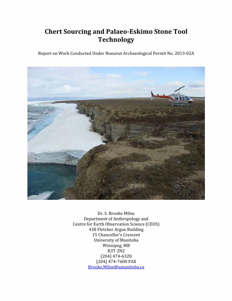
Chert Sourcing and Palaeo-Eskimo Stone Tool Technology
Report on Work Conducted Under Nunavut Archaeological Permit No. 2013-02A
Dr. S. Brooke Milne Department of Anthropology and
Centre for Earth Observation Science (CEOS) 438 Fletcher Argue Building
15 Chancellor’s Crescent University of Manitoba
Winnipeg, MB R3T 2N2
(204) 474-6328 (204) 474-7600 FAX
NAP 2013-02A Milne, University of Manitoba
2
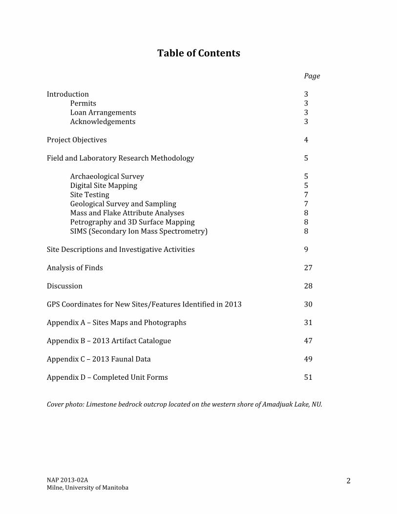
Table of Contents
Page Introduction 3 Permits 3 Loan Arrangements 3 Acknowledgements 3 Project Objectives 4 Field and Laboratory Research Methodology 5 Archaeological Survey 5 Digital Site Mapping 5 Site Testing 7 Geological Survey and Sampling 7 Mass and Flake Attribute Analyses 8 Petrography and 3D Surface Mapping 8 SIMS (Secondary Ion Mass Spectrometry) 8 Site Descriptions and Investigative Activities 9 Analysis of Finds 27 Discussion 28 GPS Coordinates for New Sites/Features Identified in 2013 30 Appendix A – Sites Maps and Photographs 31 Appendix B – 2013 Artifact Catalogue 47 Appendix C – 2013 Faunal Data 49 Appendix D – Completed Unit Forms 51 Cover photo: Limestone bedrock outcrop located on the western shore of Amadjuak Lake, NU.

NAP 2013-02A Milne, University of Manitoba
3
Introduction This report describes archaeological fieldwork activities conducted between July 14 –19, 2013 under Nunavut Archaeologist Permit 2013-02A. This research represents the second year in a four-year program headed by the principal investigator, Dr. Brooke Milne (Anthropology, CEOS, University of Manitoba). Project co-investigators include: Drs. Mostafa Fayek (Geological Sciences, University of Manitoba), Robert W. Park (Anthropology, University of Waterloo), and Douglas R. Stenton (Director, Culture and Heritage, Government of Nunavut). Permits Other relevant permits and exemptions were acquired by Milne in advance of this research from the following agencies: Nunavut Impact Review Board File no. 12YN028 Nunavut Scientific Research License no. 01 16 12N-A (Nunavut Research Institute) Qikiqtani Inuit Association no. Q12X022 Aboriginal Affairs and Northern Development Canada (AAND) Separate reports were sent to these agencies describing the 2013 fieldwork. Loan Arrangements In December of 2013, a catalogue of all artifacts collected under this permit was sent to the Canadian Museum of Nature. An official application to borrow these materials for analysis was also submitted at that time. Acknowledgements Funding for this research was provided by the Social Sciences and Humanities Research Council of Canada in the form of an Insight Grant (435-2012-1176) awarded to Milne (Principal Investigator), Dr. Robert Park (Co-Investigator; University of Waterloo), Dr. Mostafa Fayek (Co-Investigator; University of Manitoba), and Dr. Douglas Stenton (Collaborator; Director, Culture and Heritage, Government of Nunavut). Rick Armstrong and Mary Ellen Thomas (Nunavut Research Institute) provided logistical support while in Iqaluit. Logistical air support was provided by the Polar Continental Shelf Program (project #647-13). The field team was led by the author and included Fayek and David Landry (PhD candidate, Anthropology, University of Manitoba). Dr. Rachel E. ten Bruggencate (Post Doctoral Fellow, Anthropology, University of Manitoba) created the maps included in this report from Milne’s field notes, and is the lead in overseeing the selection and preparation of all chert samples for geochemical testing. Deanna McAvoy (MA candidate, Anthropology, University of Manitoba) processed and catalogued all of the materials collected in 2013, and completed the faunal analysis included in Appendix C. We all gratefully acknowledge all of these agencies and people for their generous support.

NAP 2013-02A Milne, University of Manitoba
4
Project Objectives Archaeologists refer to the original inhabitants of the Arctic as Palaeo-Eskimos, and chert or ammaaq was the most common type of stone they used to make their stone tools. However, very little is known about how these people acquired this stone, when, and from where exactly. Oral histories have described the presence of chert in the interior, and Amadjuak Lake or Ammaaq Lake is thought to be an especially good place to find it. Our previous research in the area has identified widespread surface scatters of this stone thereby confirming its presence in the interior of the island. We have also been able to determine that the surface chert derives from the same geological source, possibly the local bedrock weathering in situ. However, our analyses of archaeologically derived chert indicate that other yet unidentified sources of this stone were being used by Palaeo-Eskimo peoples for their toolkits. As such, one of our main research objectives for this project is to locate these unknown source areas so as to gain a more complete understanding of human technological organization in this region of Nunavut. Stone is fixed geologically yet human populations must move geographically to hunt, visit, etc. As such, stone-tool using peoples had to carry with them the stone they needed to make their tools as they moved across the landscape away from source locations. Stone is a reductive medium so as tools are made, used, and maintained, pieces of the stone are removed and discarded at various places on the landscape. If we can geochemically fingerprint the sources of the stone and then trace where people were carrying it during their seasonal round, it will enable us to use the stone as a proxy for human behaviour to interpret settlement, mobility, trade, and culture change over time. Our current four-year research project builds on our previous results (see Milne et al. 2009, 2011) and will apply a sourcing methodology we’ve developed for chert toolstone to achieve the following objectives: (1) identify other potential sources of chert used by the Palaeo-Eskimos in the interior of southern Baffin Island; (2) determine if the Palaeo-Eskimos who used neighbouring coastal regions also used chert from these same inland sources; (3) combine our inland and coastal findings to reconstruct Palaeo-Eskimo mobility patterns and settlement using chert as a proxy; and, (4) develop a database of chert distribution, both from archaeological sites and source locations, and make it available as a resource of others studying stone tool technology in Nunavut. To meet our objectives, we conducted two seasons of geological and archaeological field survey on southern Baffin Island (i.e. 2012, 2013) to collect additional raw chert samples to expand our existing comparative database, and to locate and test new Palaeo-Eskimo sites in the region. Due to unforeseen logistical issues in 2012, we were unable to access the interior region and instead carried out a limited survey near Iqaluit, NU to explore local rock formations. This work determined that there are no chert-bearing rocks in this region thus ruling it out as a possible source area. Fortunately, in 2013 we did reach the interior and spent six days exploring the local geology and surveying for new sites.

NAP 2013-02A Milne, University of Manitoba
5
Field and Laboratory Research Methodology The 2013 field season was critical to the success of the larger sourcing project given the difficulties encountered in 2012. As such, two field seasons had to be compressed into one if all of the areas of interest identified for this project were to be visited. Accordingly, attention was focused on four geographic regions: the northwest shore of Mingo Lake, south Amadjuak Lake, and the mouths of Hone and Nuvungmiut Rivers where they drain into Amadjuak Lake. Eight days of helicopter time were available through PCSP starting on July 13 and ending on July 20, inclusive. However, two of these days were lost to inclement weather (i.e. July 13 and 20). The field team, consisting of Milne, Fayek, and Landry, flew daily from Iqaluit to the interior and back from July 14 – 19. Activities planned for the 2013 field season included the following:
Revisiting two known sites (LdFa-1, LeDx-42) to document them using a newly acquired Leica C10 laser topographic scanner
Conducting geological survey in the vicinity of LdFa-1 and LeDx-42 to document the local rock formations and to locate possible in situ outcrops of chert toolstone
Identify and sample “chert island” Identify and sample quarry sites where in situ outcrops of chert toolstone were
extracted/mined by Palaeo-Eskimo toolmakers Locate previously unknown archaeological sites in the vicinities of these source
areas, test them to determine cultural affiliation, and scan them using the Leica C10 Collect additional raw and archaeological chert samples from all investigated
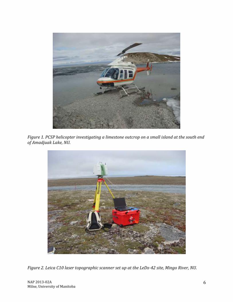
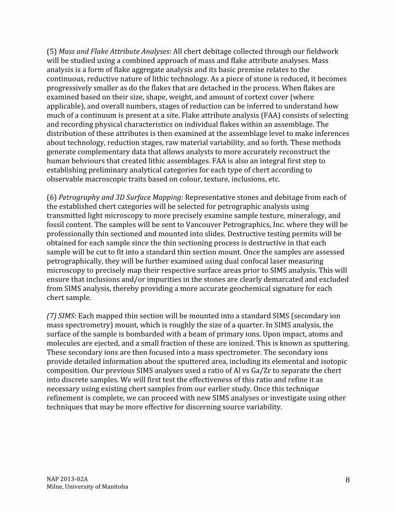
locations for geochemical testing Data acquisition in the field involved four methods: (1) archaeological survey; (2) digital site mapping; (3) site testing; and, (4) geological survey and sampling. Lab analysis of the recovered samples will include: (5) Mass and Flake Attribute Analyses; (6) Petrography and 3D Surface Mapping; and, (7) SIMS. (1) Archaeological Survey: Given the logistics of this project, survey was done predominantly from a helicopter in an effort to identify potential chert outcrops and related archaeological sites (see Figure 1). When an area of interest was identified, the crew landed and carried out systematic pedestrian surveys. This involved walking at set intervals with each person spaced 2 to 5 meters apart over distances ranging from several meters to a kilometer or more. Items of interest were described in field notes, recorded using GPS, and photographed. (2) Digital Site Mapping: Using a Leica C10 laser topographic scanner, two known sites were digitally recorded to create detailed digital maps including 360-degree full dome scans and 3D fly-through movies (see Figure 2). These kinds of digital records will allow us to “bring” sites to local stakeholders and the public so that they can interact with these places firsthand. Four targets were set up at each site and three to four separate scans were taken. These scans are then “knit” together to produce a 3D record of the site.
NAP 2013-02A Milne, University of Manitoba
6
Figure 1. PCSP helicopter investigating a limestone outcrop on a small island at the south end of Amadjuak Lake, NU.
Figure 2. Leica C10 laser topographic scanner set up at the LeDx-42 site, Mingo River, NU.

NAP 2013-02A Milne, University of Manitoba
7
(3) Site Testing: Test units were placed in those areas that exhibited high concentrations of surface artifacts (e.g. debitage) and/or that were located within identified features (e.g. a tent ring). Test units ranged in size from 25 x 25 cm to 50 x 50 cm. Prior to excavation, the surface area of each unit was photographed and/or mapped, and the location was recorded using GPS. When formal and informal artifacts were found, their precise three-dimensional locations were recorded on standardized unit forms. All lithic debitage and faunal remains were collected en masse by unit. In those instances where units were especially productive, bulk soil samples were collected to recover small sized artifacts and possible micro-debitage (i.e. flakes smaller than 1/8”). Given the space restrictions of the helicopter, nested ¼” and 1/8” screens could not be transported daily into the field; therefore, excavated back dirt was not screened. All completed test units were photographed (including their profiles) and mapped prior to back filling; back filled units were also photographed. Every effort was made to return the surface of each test unit back to its original state prior to excavation. (4) Geological Survey and Sampling: Geological survey and sampling followed standard procedures as well. Geological hammers were used to acquire rock samples for testing from outcrops of interest (see Figure 3). The outcrop was photographed prior to acquisition, and detailed notes of its appearance, structure, and composition were made. Each sample specimen was photographed and bagged using a standardized labeling method so that samples can be easily linked back to their original outcrop location.
Figure 3. Fayek sampling a limestone boulder near the LdFa-1 site, Mingo Lake, NU.
NAP 2013-02A Milne, University of Manitoba
8
(5) Mass and Flake Attribute Analyses: All chert debitage collected through our fieldwork will be studied using a combined approach of mass and flake attribute analyses. Mass analysis is a form of flake aggregate analysis and its basic premise relates to the continuous, reductive nature of lithic technology. As a piece of stone is reduced, it becomes progressively smaller as do the flakes that are detached in the process. When flakes are examined based on their size, shape, weight, and amount of cortext cover (where applicable), and overall numbers, stages of reduction can be inferred to understand how much of a continuum is present at a site. Flake attribute analysis (FAA) consists of selecting and recording physical characteristics on individual flakes within an assemblage. The distribution of these attributes is then examined at the assemblage level to make inferences about technology, reduction stages, raw material variability, and so forth. These methods generate complementary data that allows analysts to more accurately reconstruct the human behviours that created lithic assemblages. FAA is also an integral first step to establishing preliminary analytical categories for each type of chert according to observable macroscopic traits based on colour, texture, inclusions, etc. (6) Petrography and 3D Surface Mapping: Representative stones and debitage from each of the established chert categories will be selected for petrographic analysis using transmitted light microscopy to more precisely examine sample texture, mineralogy, and fossil content. The samples will be sent to Vancouver Petrographics, Inc. where they will be professionally thin sectioned and mounted into slides. Destructive testing permits will be obtained for each sample since the thin sectioning process is destructive in that each sample will be cut to fit into a standard thin section mount. Once the samples are assessed petrographically, they will be further examined using dual confocal laser measuring microscopy to precisely map their respective surface areas prior to SIMS analysis. This will ensure that inclusions and/or impurities in the stones are clearly demarcated and excluded from SIMS analysis, thereby providing a more accurate geochemical signature for each chert sample. (7) SIMS: Each mapped thin section will be mounted into a standard SIMS (secondary ion mass spectrometry) mount, which is roughly the size of a quarter. In SIMS analysis, the surface of the sample is bombarded with a beam of primary ions. Upon impact, atoms and molecules are ejected, and a small fraction of these are ionized. This is known as sputtering. These secondary ions are then focused into a mass spectrometer. The secondary ions provide detailed information about the sputtered area, including its elemental and isotopic composition. Our previous SIMS analyses used a ratio of Al vs Ga/Zr to separate the chert into discrete samples. We will first test the effectiveness of this ratio and refine it as necessary using existing chert samples from our earlier study. Once this technique refinement is complete, we can proceed with new SIMS analyses or investigate using other techniques that may be more effective for discerning source variability.

NAP 2013-02A Milne, University of Manitoba
9
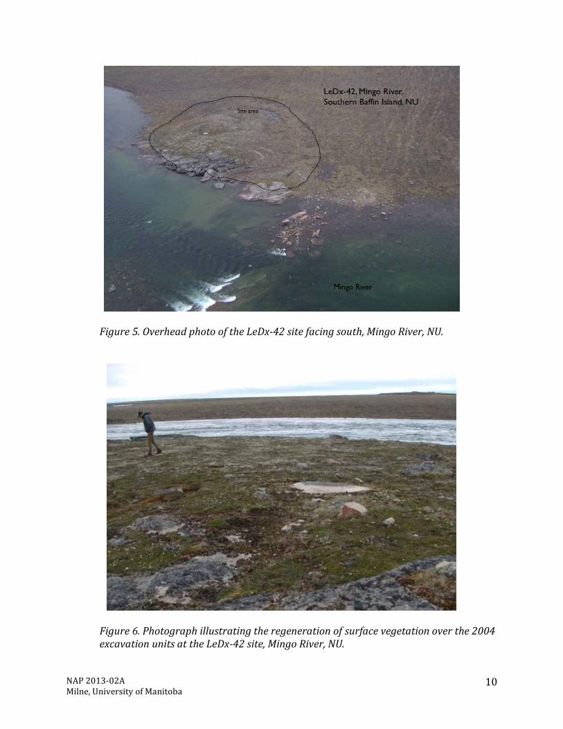
Site Descriptions and Investigative Activities In 2013, two previously documented sites were revisited (LeDx-42; LdFa-1) and four undocumented sites were located (LdDt-7; LdFb-13; LdDx-2; LbDt-1). Each site is described individually, including any subsurface investigation conducted. LeDx-42 LeDx-42 is a multi-component site located on a bedrock outcrop that juts into the Mingo River approximately 2 km from the southwest shore of Amadjuak Lake (see Figures 4 and 5). This is the first time LeDx-42 has been revisited since Milne identified it in 2004. The site is in excellent condition. The test units and excavated areas from 2004 have regenerated well and are nearly undetectable (see Figure 6). Surface scatters of chert flakes are still visible but concentrations are minimal such that no artifacts are in immediate danger of being destroyed and/or lost. Caribou traffic appears to be non-existent at present thus greatly reducing potential site damage due to trampling.
Figure 4. Google Earth map of the LeDx-42 site along the south shore of the Mingo River, approximately 2 km from the southwest shore of Amadjuak Lake, NU.
Investigative site activities in 2013 included digital site mapping and geological survey. Fayek found that the bedrock in the area is igneous in origin meaning that it is not chert bearing. Large glacial erratics dot the landscape near the site (which is why it can only be accessed via boat or helicopter) and some of them are silicified limestone. Samples were taken for analysis but the material is too coarse to be of use for stone tool production purposes. Therefore, there are no immediate outcrops of chert near the site.
NAP 2013-02A Milne, University of Manitoba
10
Figure 5. Overhead photo of the LeDx-42 site facing south, Mingo River, NU.
Figure 6. Photograph illustrating the regeneration of surface vegetation over the 2004 excavation units at the LeDx-42 site, Mingo River, NU.

NAP 2013-02A Milne, University of Manitoba
11
Milne and Landry set up four targets at the site and took three separate scans. The scan data are being processed to create a detailed topographic map and a digital fly-through movie so that the site can be “visited” virtually in the future. A small number of chert flakes found near the landing gear of the helicopter were collected to prevent damage or loss as the aircraft departed from the site. No other materials were collected. LdFa-1 LdFa-1 is a large, multi-component site located on the northwest shore of Mingo Lake in the lee of an extensive moraine feature (see Figures 7 and 8). The site was first investigated by Stenton in 1991, and subsequently by Milne in 2004 and 2007, and Park in 2008. Observations made at LdFa-1 in 2013 indicate the site is in good condition for the most part except for those features that are closest to the Mingo Lake shoreline. Seasonal ice push is churning up these areas, as has been previously observed by Milne and Park. Visible surface scatters of lithics and faunal were noted near the shoreline but no features (i.e. tent rings) are in immediate danger of extensive disturbance.
Figure 7. Google Earth map of the LdFa-1 site, northwest shore of Mingo Lake, NU.

NAP 2013-02A Milne, University of Manitoba
12
Figure 8. Overhead photograph of the LdFa-1 site illustrating the site’s location on the northwest shore of Mingo Lake, NU and in the lee of the extensive moraine feature that dominates the local landscape.
The main site proper is in good condition and stable. Previous excavation units are regenerating well and are unnoticeable in some locations (see Figure 9). There are still visible surface scatters of chert flakes and faunal bones throughout the site area; scatters in Area 2 are particularly evident. A limited number of chert flakes were collected in those areas that had been backfilled and thus have no provenience. No formal artifacts were observed on the surface. Like at LeDx-42, caribou traffic is virtually non-existent in the area so the threat of damage due to trampling is not an immediate concern. Investigative site activities in 2013 included digital site mapping and geological survey. Milne and Landry spent two days trying to scan the site. Strong winds made the first attempt impossible since the internal level of the scanner could not be stabilized. The second attempt to scan was successful but strong winds continued to create problems (e.g. blowing down target poles; draining the scanner batteries). Four targets were set up and three scans were taken. These data are being processed to create a detailed topographic map and a digital fly-through movie so that the site can be “visited” virtually in the future. Fayek carried out an extensive geological survey near the site covering approximately 20 km. He identified many large limestone boulders in the vicinity of the site that contained within them a tan brown chert of moderate to poor quality (see Figure 10). He also noted the widespread surface scatters of chert previously observed by Stenton, Milne, and Park. Still though, there does not appear to be an in situ outcrop for the chert near the site.

NAP 2013-02A Milne, University of Manitoba
13
Several large silicified limestone erratics were sampled, as were the limestone boulders noted already. Samples of the surface scattered chert were also collected for testing.
Figure 9. Photograph of Landry beside Area 1 excavation units illustrating the level of regeneration over units excavated by Park in 2008.
Figure 10. Coarse-grained tan brown chert observed in a limestone boulder near the LdFa-1 site, Mingo Lake, NU.

NAP 2013-02A Milne, University of Manitoba
14
LdDt-7 This site was identified from the air on July 14, 2013 near the southern end of Amadjuak Lake where it meets the mouth of the Hone River (see Figure 11). The site is large and includes at least six tent ring concentrations and adjacent cache-like features spread out on either side of a creek that drains into the Hone River (see Figure 12).
Figure 11. Google Earth map illustrating the location of LdDt-7 along the shores of the Hone River just south of Amadjuak Lake, NU.
The site is generally in stable condition although the southern portion is boggy and wet due to seasonal run off. Some recent tire tracks, likely from an ATV, were noted and in close proximity to the two cache-like features and single tent ring that comprise this area of the site (see Figure 13). There are scatters of caribou bone near the caches and some of it is recent suggesting, along with the ATV tracks, a recent use of the site. There are at least 13 tent rings and 4 cache-like features that are situated at several different elevations throughout the site area. These dwellings are large and well defined, and several of them have visible sleeping platforms that were constructed using flat limestone slabs. The perimeter rocks defining some of the tent rings are deeply embedded in the vegetation. In observing the perimeter rocks forming one of the large tent rings in the centre of the site, Fayek noticed that the one rock had cracked likely due to the effects of annual freeze-thaw cycles. In locating the piece that had spalled off, it was noted that it contained a small nodule of chert. The spall was refitted to the perimeter rock to confirm its origin, and the chert within it was collected for geochemical analysis (see Figure 14). No other collections were made at the site. No surface artifacts were observed anywhere; therefore, it is not possible to confirm cultural affiliation(s) for the site.

NAP 2013-02A Milne, University of Manitoba
15
Figure 12. Image outlining the aerial layout of LdDt-7 in relation to the creek dividing the site. Each tent ring concentration is noted with the dashed white lines.
Figure 13. Tent ring and caches located in southern area of LdDt-7 looking northwards across creek.
NAP 2013-02A Milne, University of Manitoba
16
Figure 14. Photographs illustrating the spalled perimeter rock containing chert at the LdDt-7 site.
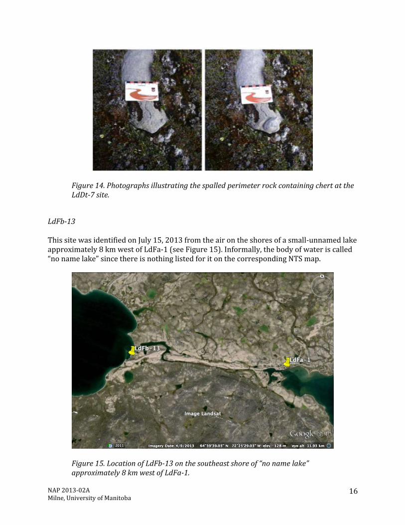
LdFb-13 This site was identified on July 15, 2013 from the air on the shores of a small-unnamed lake approximately 8 km west of LdFa-1 (see Figure 15). Informally, the body of water is called “no name lake” since there is nothing listed for it on the corresponding NTS map.
Figure 15. Location of LdFb-13 on the southeast shore of “no name lake” approximately 8 km west of LdFa-1.

NAP 2013-02A Milne, University of Manitoba
17
The site consists of three tent rings situated approximately 13 meters away from the lake’s edge on a limestone gravel beach (see Figure 16). The site appears stable although ice push from the lake has created a series of small gravel ridges between the site proper and the adjacent shoreline.
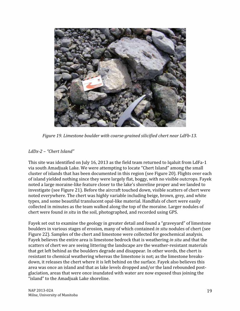
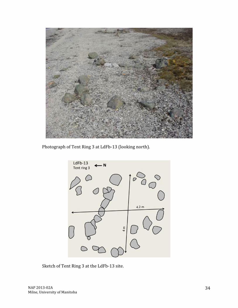
Figure 16. View of the three tent rings located at LdFb-13 facing east. Tent Ring 2 is heavily constructed possessing a double line of rocks along its perimeter. It also has a well-defined alcove located to the left inside of what appears to be the entrance (see Figure 17). The other two tent rings are also well defined but not as heavily constructed. There is considerable lichen growth on all of the perimeter rocks and some areas are covered heavy moss. No surface artifacts were observed; however, there is an abundance of naturally occurring chert pebbles within the gravel. Samples of this chert were collected for geochemical analysis. Investigative activities at the site included foot survey, sketch mapping, and GPS recording of site coordinates. A small random test pit measuring 50 cm x 40 cm was excavated in Tent Ring 2 in an effort to assess the site’s cultural affiliation (see Figure 18). The test was entirely sterile; therefore, the time of occupation is unknown. Fayek surveyed the area surrounding the site, which is bordered by the same moraine feature that runs continuously on the landscape from the northwest shore of Mingo Lake. He observed more limestone boulders in the area like those found near LdFa-1, and many of them are silicified. These boulders contain a coarse grained chert that is unsuitable for chipped stone tool production (see Figure 19). Samples of the boulders were taken for geochemical analysis.

NAP 2013-02A Milne, University of Manitoba
18
Figure 17. Sketch map of Tent Ring 2 at the LdFb-13 site.
Figure 18. View of random sterile test pit excavated within Tent Ring 2 at the LdFb-13 site (facing south).
4m
4m
1m
moss
limestone
LdFb-13Tentring2
N
NAP 2013-02A Milne, University of Manitoba
19
Figure 19. Limestone boulder with coarse-grained silicified chert near LdFb-13.
LdDx-2 – “Chert Island” This site was identified on July 16, 2013 as the field team returned to Iqaluit from LdFa-1 via south Amadjuak Lake. We were attempting to locate “Chert Island” among the small cluster of islands that has been documented in this region (see Figure 20). Flights over each of island yielded nothing since they were largely flat, boggy, with no visible outcrops. Fayek noted a large moraine-like feature closer to the lake’s shoreline proper and we landed to investigate (see Figure 21). Before the aircraft touched down, visible scatters of chert were noted everywhere. The chert was highly variable including beige, brown, grey, and white types, and some beautiful translucent opal-like material. Handfuls of chert were easily collected in minutes as the team walked along the top of the moraine. Larger nodules of chert were found in situ in the soil, photographed, and recorded using GPS. Fayek set out to examine the geology in greater detail and found a “graveyard” of limestone boulders in various stages of erosion, many of which contained in situ nodules of chert (see Figure 22). Samples of the chert and limestone were collected for geochemical analysis. Fayek believes the entire area is limestone bedrock that is weathering in situ and that the scatters of chert we are seeing littering the landscape are the weather-resistant materials that get left behind as the boulders degrade and disappear. In other words, the chert is resistant to chemical weathering whereas the limestone is not; as the limestone breaks-down, it releases the chert where it is left behind on the surface. Fayek also believes this area was once an island and that as lake levels dropped and/or the land rebounded post-glaciation, areas that were once inundated with water are now exposed thus joining the “island” to the Amadjuak Lake shoreline.

NAP 2013-02A Milne, University of Manitoba
20
Figure 20. Google Earth map illustrating the location of the small islands along the southwest shore of Amadjuak Lake, and the location of “Chert Island” (LdDx-2).
Figure 21. View of “moraine-like” feature near LdDx-2 on “Chert Island.” Dotted outline indicates area that was likely once submerged creating an island.

NAP 2013-02A Milne, University of Manitoba
21
Figure 22. Limestone boulder “graveyard” located near LdDx-2 on “Chert Island.”
Figure 23. Aerial photograph of the Chert Island site (LdDx-2) outlining the distribution of the 9 identified areas (note: there is no area 4).
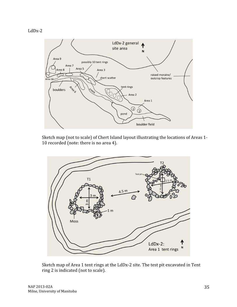
Upon further survey, Landry identified two heavily constructed tent rings a few hundred meters away from the boulder “graveyard.” There is a small stream beside the tent rings, which drains down a gulley approximately 1.5 – 2 km to the shore of Amadjuak Lake. Further survey along the edges of the gulley identified nine other areas, most of which include tent rings and dense lithic scatters (see Figure 23). To facilitate description and

NAP 2013-02A Milne, University of Manitoba
22
investigation, these “areas” were each given a number, and comprise the following features:
Area 1: two well defined tent rings Area 2: four possible tent rings Area 3: diffuse lithic scatter Area 5: as many as ten possible tent rings and other hearth-like features Area 6: diffuse lithic scatter with one or more possible tent rings Area 7: diffuse lithic scatter with one or more possible tent rings Area 8: a large tent ring with depression in the center; diffuse lithic scatter Area 9: raised terrace overlooking Amadjuak Lake with a large lithic scatter Area 10: flat undefined area near the small protected inlet that connects to
Amadjuak Lake; diffuse lithic scatter There is no Area 4 due to a miscount during the survey. Plan maps and photos of each area are included in Appendix A. A limited number of surface artifacts indicate an early Palaeo-Eskimo occupation, namely by the Pre-Dorset. Six small test pits (i.e. 25 x 25 cm; 50 x 50 cm) were excavated in Areas 10, 8, 5, 3, 2, and 1 (see Figure 24). Chert debitage dominated the recovered artifacts while Areas 2 and 3, respectively, yielded a burin spall. Several microblade fragments, and a possible microblade core fragment were also found on the surface in Area 3. Two caribou bones were collected; one with clear cut-marks in Area 3 and a heavily bleached vertebra located approximately 8 meters away from the chert scatters identified in Areas 7 and 8. All of the test pits went sterile at 7-9 cm depth below surface (DBS). Each one was excavated to between 10-12 cm DBS to ensure no other materials were missed. Due to weather and time, the site was not scanned. Each area was, however, photographed from the ground and air, sketched, and recorded with GPS.
Figure 24. Overhead view of test pit excavated in Area 5, Chert Island, NU.

NAP 2013-02A Milne, University of Manitoba
23
LbDt-1 – Hone River Quarry This site was first spotted from the air on July 16, 2013 when Landry noticed a row of tent rings situated above a prominent limestone outcrop on the Hone River. Fayek recorded the location and the team returned to investigate further at the end of the day on July 17, 2013. The site is located on the south shore of the Hone River approximately 62 nautical miles from Iqaluit (see Figure 25). There is a fast moving set of rapids cutting through the igneous bedrock formations to the east of the site, and the flow of the river is strong. A small island is present in the middle of the river near the site and comprises large boulders, sand, and smaller nodules and gravel (see Figure 26).
Figure 25. Google Earth map illustrating the location of LbDt-1, Hone River, NU. As the helicopter touched down near the row of tent rings, dense scatters of chert could be seen. The tent rings are well defined and deeply embedded in the surface vegetation. There is considerable lichen growth on the perimeter rocks suggesting they are very old. Milne located a burin spall and lithic scatter near the tent rings, indicating minimally an early Palaeo-Eskimo cultural affiliation. Fayek investigated the outcrop near the river while Milne and Landry continued to survey the area near the tent rings. Dense scatters of chert were observed in every investigated location; chert was littering the ground. Fayek found abundant in situ nodules of chert throughout the limestone bedrock exposure. These nodules were found eroded all over the cobble beach making it easy to pick up large pieces of useable toolstone in this area (see Figures 27 and 28).

NAP 2013-02A Milne, University of Manitoba
24
Figure 26. Overhead photo illustrating the upper and lower components of the LbDt-1 site, and other features described in the larger site area.
Figure 27. In situ chert nodules within limestone bedrock outcrop at the LbDt-1 site, Hone River, NU.

NAP 2013-02A Milne, University of Manitoba
25
Figure 28. Fayek collecting samples of raw chert exposed in the limestone bedrock outcrop and scattered on the beach at the LbDt-1 site, Hone River, NU.
Further investigation along the riverbanks in the lower area of the site identified significant concentrations of lithic material eroding into the river (see Figure 29). There appears to be a depression in this area containing the remains of at least two tent rings and a possible cache feature (see Figure 30). The river is undercutting this deposit and it likely that a significant portion of it has been washed away already. To prevent further loss of material, a large amount of chert debitage was collected and bagged en masse. So much material is eroding out of the bank that it is recommended this portion of the site be salvaged since it is just a matter of time before it slumps into the river (see Figure 31).
Figure 29. View of lithic material eroding from the cultural deposit situated beside the bank of the Hone River at the LbDt-1 site, NU.

NAP 2013-02A Milne, University of Manitoba
26
Figure 30. View of depression located in lower area of LbDt-1 site with possible tent rings and cache-like feature. This site is massive in its overall extent (e.g. 5-6 acres) and it is divided into an upper and lower area to facilitate description and investigation (see Figure 26). The upper portion of the site is in stable condition with no immediate threats to the features recorded. The lower portion of the site is generally stable as well with the exception of those areas described next to the riverbank.
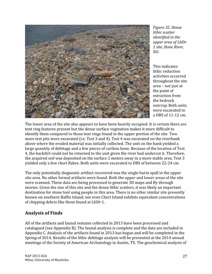
A massive lithic debitage scatter spanning close to an acre was identified overlooking the river in the upper site area (see Figures 26 and 32). The density of flakes indicates intensive repetitive reduction activities. The amount of lichen cover on these flakes attests to a lack of post-depositional disturbance. Roughly
300 m away from the edge of the outcrop there is a row of well-defined, heavily constructed tent rings. There are five clearly visible tent rings – 3 in one area; 2 in another – with a large number of boulders separating them, which may well be tent rings too but their perimeters are not as well defined. There are numerous smaller features situated nearby the tent rings. These features resemble hearths in some instances whereas others are much larger and look like windbreaks, possibly to provide cover for a hearth contained within. All of the features are deeply embedded in the ground with dense lichen cover.
Dense scatters of lithic debitage were observed inside the tent rings and outside their walls as well. Two small test pits (50 x 50 cm) were excavated in tent rings 1 and 2, which yielded surprisingly large quantities of lithic debitage. Figure 31. View of deposit in lower area of LbDt-1 site illustrating the slumping caused by the river undercutting the site.
NAP 2013-02A Milne, University of Manitoba
27
Figure 32. Dense lithic scatter identified in the upper area of LbDt-1 site, Hone River, NU. This indicates lithic reduction activities occurred throughout the site area – not just at the point of extraction from the bedrock outcrop. Both units were excavated to a DBS of 11-12 cm.
The lower area of the site also appears to have been heavily occupied. It is certain there are tent ring features present but the dense surface vegetation makes it more difficult to identify them compared to those tent rings found in the upper portion of the site. Two more test pits were excavated (i.e. Test 3 and 4). Test 4 was excavated on the riverbank above where the eroded material was initially collected. The unit on the bank yielded a large quantity of debitage and a few pieces of caribou bone. Because of the location of Test 4, the backdirt could not be returned to the unit given the river had undercut it. Therefore, the acquired soil was deposited on the surface 2 meters away in a more stable area. Test 3 yielded only a few chert flakes. Both units were excavated to DBS of between 22-24 cm. The only potentially diagnostic artifact recovered was the single burin spall in the upper site area. No other formal artifacts were found. Both the upper and lower areas of the site were scanned. These data are being processed to generate 3D maps and fly-through movies. Given the size of this site and the dense lithic scatters, it was likely an important destination for stone tool using people in this area. There is no other similar site presently known on southern Baffin Island; not even Chert Island exhibits equivalent concentrations of chipping debris like those found at LbDt-1.
Analysis of Finds All of the artifacts and faunal remains collected in 2013 have been processed and catalogued (see Appendix B). The faunal analysis is complete and the data are included in Appendix C. Analysis of the artifacts found in 2013 has begun and will be completed in the Spring of 2014. Results of the lithic debitage analysis will be presented at the 2014 annual meetings of the Society of American Archaeology in Austin, TX. The geochemical analysis of

NAP 2013-02A Milne, University of Manitoba
28
the raw chert samples has also begun. When the analytical protocol has been refined and verified, analysis of archaeological chert will begin. Destructive testing permits will be acquired prior to thin sectioning and SIMS analysis. This component of the project is anticipated to begin in late January or early February 2014.
Discussion The 2013 field season was definitely a success. The identification of Chert Island (LdDx-2) and the Hone River quarry (LbDt-1) further affirm local oral histories that the interior of southern Baffin Island is the place chert comes from. These are the first identified locations where Palaeo-Eskimo toolmakers acquired chert from in situ outcroppings. They are the elusive quarries that Stenton, Milne, and Park have tried to locate for over 10 years. The results of the geological survey have enabled Fayek to come up with a model accounting for the occurrence of chert in the interior (see Figure 34). The pervasive limestone bedrock that characterizes the regions near Nettilling, Amadjuak, and Mingo Lakes comprises multiple stratigraphic layers of which only some contain chert. Limestone is susceptible to mechanical and chemical weathering processes, and over time degrades and breaks down. Chert is resistant to chemical alteration yet it will break down into progressively smaller pieces until it is literally reduced to sand. As the chert-bearing limestone strata degrade, the chert becomes liberated and represents the final remnants of
the original bedrock formation. This surface exposed chert is susceptible to annual freeze-thaw cycles, which would cause it to breakdown into the wide spread surface scatters found near archaeological sites like LdFa-1, among others. Therefore, the source of the raw chert scatters appears to derive from the local limestone bedrock weathering in situ. In order to confirm this, our analyses of the in situ chert from LbDt-1 and LdDx-2 will be compared to the raw chert fragments found in nearby areas. If the geochemical signatures are consistent, it will suggest that the chert is from those same geological strata; if not, further survey in the interior will be needed to better understand how many potential source areas may exist and just how variable they may be. Figure 34. Fayek’s model for chert nodules.

NAP 2013-02A Milne, University of Manitoba
29
All of the research activities set out for the 2013 field season were successfully completed (see p. 5). Digital scanning data were acquired at LdFa-1 and LeDx-42. Additionally, LbDt-1 was scanned, and detailed maps for each site are being constructed. The geological survey produced a model accounting for the widespread chert scatters found in this region of the island’s interior. Moreover, it acquired a more precise understanding of the rock formations in the investigated areas, which will facilitate future provenance studies on useable lithic raw materials on southern Baffin Island. The research team identified the location of Chert Island and the Hone River Quarry, and collected raw and archaeological chert samples from both locations for analysis. The material collected in 2013 will considerably expand the comparative geochemical database for chert toolstone found on southern Baffin Island, as will the analysis of the archaeological samples. Collectively, the research objectives of the broader four-year project described on p. 4 can now be met given the success of the 2013 archaeological and geological field season.

NAP 2013-02A Milne, University of Manitoba
30
GPS Coordinates for New Sites/Features Identified in 2013 Site Location Reading Elevation
LdDt-7 Cluster of 6 tent rings 117 m Cluster of 3 tent rings 115 m Cache feature 118 m Cluster of 2 tent rings 114 m Single tent ring 118 m LdFb-13 General site area 117 m LdDx-2 General reading 136 m Area 1 121 m Area 2 119 m Area 3 119 m Area 5 121 m Area 6 120 m Area 7 118 m Area 8 120 m Area 9 N/A Area 10 116 m LbDt-1 General reading 199 m Outcrop reading – lower 191 m Riverbank sump – lower 186 m Upper tent ring cluster 200 m Debitage scatter – upper 206 m Test 1 Tent Ring 1 197 m Test 2 Tent Ring 2 196 m Test 3 lower site 184 m Test 4 lower site 184 m

NAP 2013-02A Milne, University of Manitoba
31
Appendix A Site Maps and Photographs
LdFb-13
Overhead photograph of three tent rings at LdFb-13.
Sketch map of site layout, LdF-13 (not to scale).

NAP 2013-02A Milne, University of Manitoba
32
Photograph of Tent Ring 1 at LdFb-13 (looking south).
Sketch map of Tent Ring 1 at LdFb-13 site.

NAP 2013-02A Milne, University of Manitoba
33
Photograph of Tent Ring 2 at LdFb-13 (looking south).
Sketch of Tent Ring 2 at the LdFb-13 site.
NAP 2013-02A Milne, University of Manitoba
34
Photograph of Tent Ring 3 at LdFb-13 (looking north).
Sketch of Tent Ring 3 at the LdFb-13 site.
NAP 2013-02A Milne, University of Manitoba
35
LdDx-2
Sketch map (not to scale) of Chert Island layout illustrating the locations of Areas 1-10 recorded (note: there is no area 4).
Sketch map of Area 1 tent rings at the LdDx-2 site. The test pit excavated in Tent ring 2 is indicated (not to scale).

NAP 2013-02A Milne, University of Manitoba
36
Photo of completed test unit in Area 1 of the LdDx-2 site.
Sketch map of Area 2 at the LdDx-2 site. The location of the excavated test unit is indicated (not to scale).

NAP 2013-02A Milne, University of Manitoba
37
Photo of completed test unit in Area 2 at the LdDx-2 site.
Sketch map showing the locations of Areas 1 and 2 in rough proximity to one another, and general layout of features within them at the LdDx-2 site (not to scale).
NAP 2013-02A Milne, University of Manitoba
38
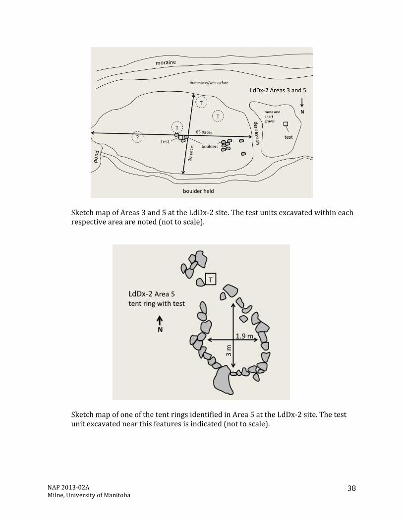
Sketch map of Areas 3 and 5 at the LdDx-2 site. The test units excavated within each respective area are noted (not to scale).
Sketch map of one of the tent rings identified in Area 5 at the LdDx-2 site. The test unit excavated near this features is indicated (not to scale).

NAP 2013-02A Milne, University of Manitoba
39
Photo of completed test unit in Area 3 at the LdDx-2 site.
Photo of completed test unit in Area 5 at LdDx-2 site.

NAP 2013-02A Milne, University of Manitoba
40
Sketch map of Area 6 (upper and lower) at the LdDx-2 site (not to scale).
Sketch map of Areas 7 and 8 at the LdDx-2 site. The location of the excavated test unit in Area 8 is indicated (not to scale).

NAP 2013-02A Milne, University of Manitoba
41
Sketch map of the tent ring identified in Area 8 of the LdDx-2 site and the test unit excavated within it (not to scale).
Photo of completed test unit in Area 8 at LdDx-2.

NAP 2013-02A Milne, University of Manitoba
42
Photo of Area 10 looking out towards the inlet that connects to Amadjuak Lake.
Photo of completed test unit excavated in Area 10 of the LeDx-2 site.
NAP 2013-02A Milne, University of Manitoba
43
LbDt-1
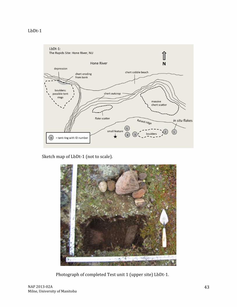
Sketch map of LbDt-1 (not to scale).
Photograph of completed Test unit 1 (upper site) LbDt-1.
NAP 2013-02A Milne, University of Manitoba
44
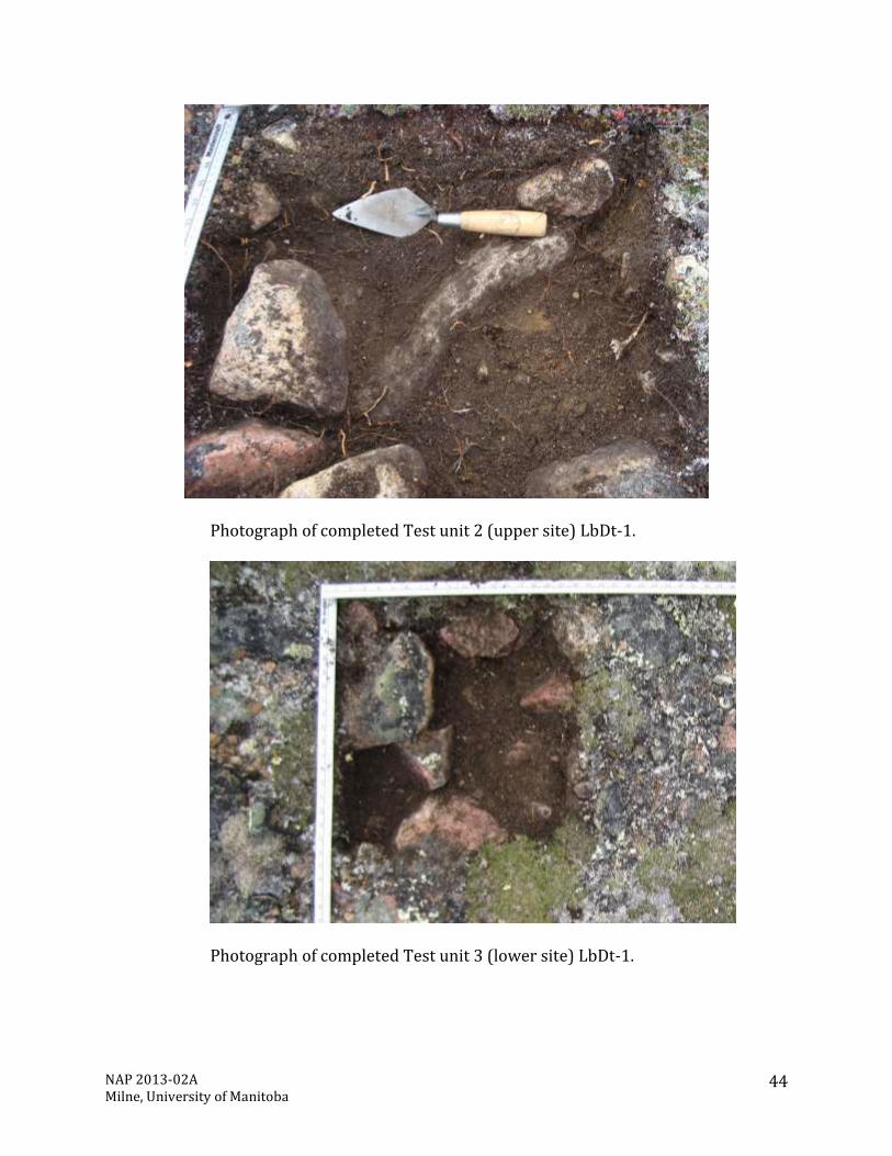
Photograph of completed Test unit 2 (upper site) LbDt-1.
Photograph of completed Test unit 3 (lower site) LbDt-1.

NAP 2013-02A Milne, University of Manitoba
45
Sketch map of Test unit 4 excavated into slumping bank to recover material falling into the Hone River (not to scale).
Photo of sketched Test unit 4 area.

NAP 2013-02A Milne, University of Manitoba
46
Photograph of completed Test unit 4 (lower site) LbDt-1.