Character Road west site....heavily trafficked and accommodates several bus routes.The Luas will...
11
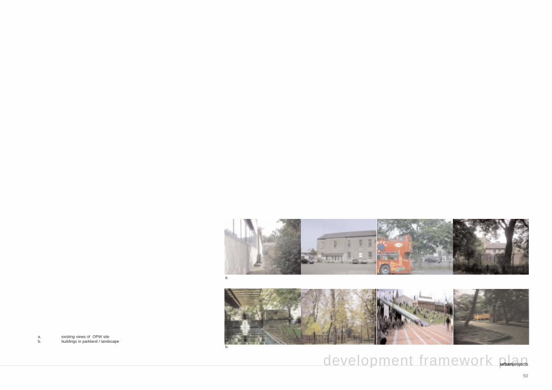
49 heuston gateway: regeneration strategy and development framework plan 3.1.7 OPW Park Curtilage should be defined for the National Monuments on the OPW site. The area is identified in this document as ‘OPW Park’. The position at the centre of the Eircom/OPW development provides a contrast to the high-density development proposed in this area. The park is between the new IMMA Avenue and Military Road. The park should therefore provide numerous pedestrian and cycle links from the Phoenix Park/Kilmainham link and St. John’s Road west site. Character • Soft landscaped area with small-scale pavilion-like buildings. • Secure, bright and extensive landscape. • Provision should be made for children – a playground area for the local community. Associated development • Small-scale pavilion-like buildings with institutional and mixed uses. • The buildings must compliment the scale of the existing National Monuments and be part of a coherent plan for the curtilage of same. • The buildings should contrast with the National Monuments with high quality contemporary design. • The National Monuments should be fully restored and given appropriate new uses. Heuston Gateway: public domain: OPW Park
Transcript of Character Road west site....heavily trafficked and accommodates several bus routes.The Luas will...

49
heuston gateway: regeneration strategy and development framework plan
3.1.7 OPW Park
Curtilage should be defined for the National Monuments on theOPW site. The area is identified in this document as ‘OPW Park’.The position at the centre of the Eircom/OPW development provides a contrast to the high-density development proposed in this area.The park is between the new IMMA Avenue and Military Road. Thepark should therefore provide numerous pedestrian and cycle linksfrom the Phoenix Park/Kilmainham link and St. John’s Road west site.
Character• Soft landscaped area with small-scale pavilion-like
buildings.• Secure, bright and extensive landscape.• Provision should be made for children – a playground
area for the local community.
Associated development• Small-scale pavilion-like buildings with institutional and
mixed uses.• The buildings must compliment the scale of the existing
National Monuments and be part of a coherent plan for the curtilage of same.
• The buildings should contrast with the National Monuments with high quality contemporary design.
• The National Monuments should be fully restored and given appropriate new uses.
Heuston Gateway: public domain: OPW Park
50
development framework planurbanprojects
a. existing views of OPW siteb. buildings in parkland / landscape
a.
b.
51
heuston gateway: regeneration strategy and development framework plan
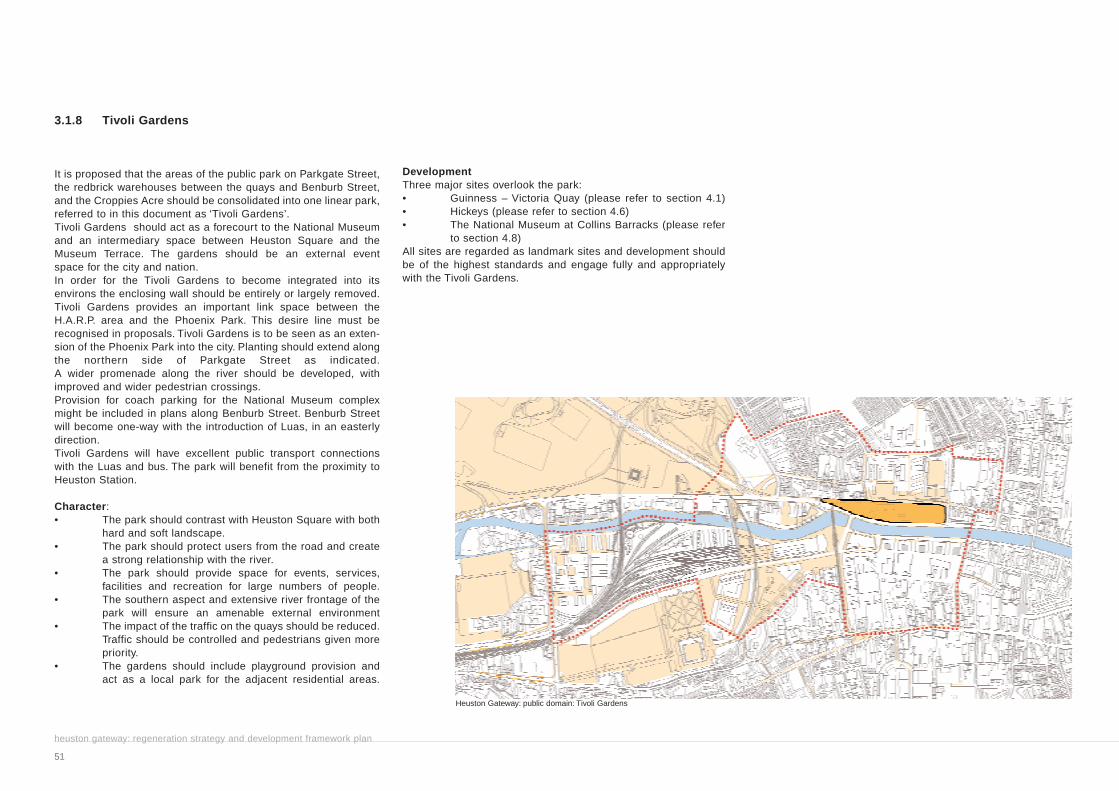
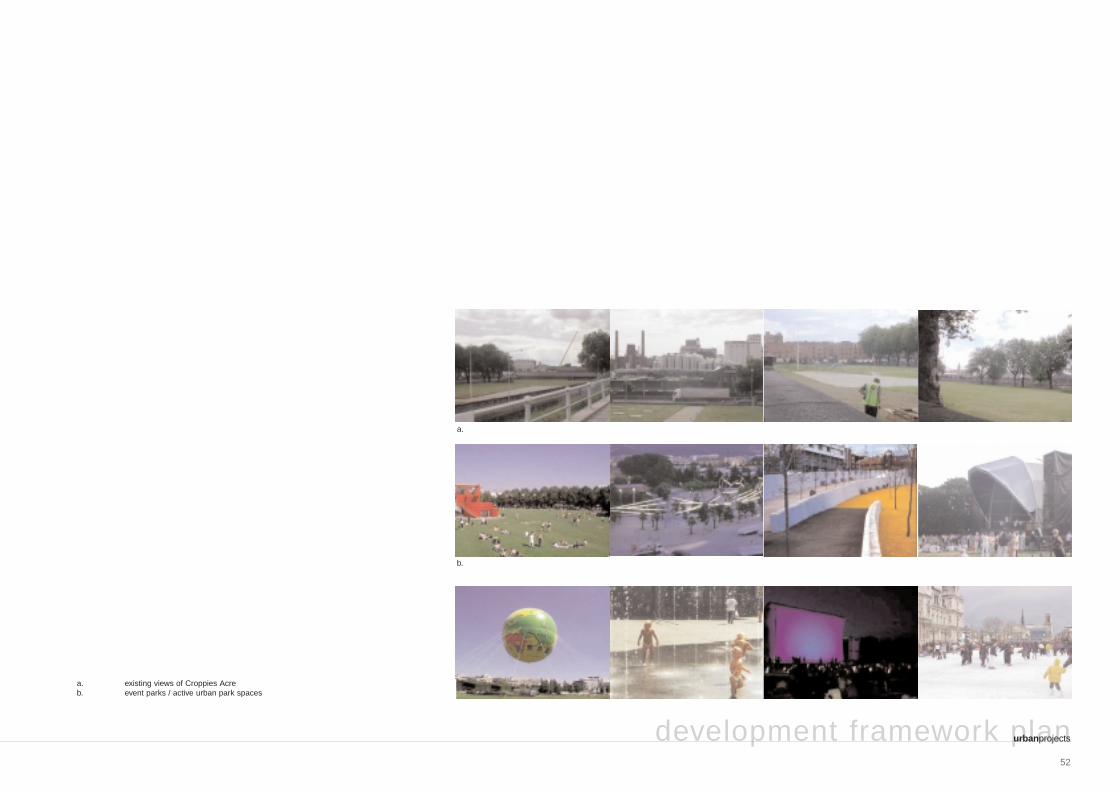
3.1.8 Tivoli Gardens
It is proposed that the areas of the public park on Parkgate Street,the redbrick warehouses between the quays and Benburb Street,and the Croppies Acre should be consolidated into one linear park,referred to in this document as ‘Tivoli Gardens’.Tivoli Gardens should act as a forecourt to the National Museumand an intermediary space between Heuston Square and theMuseum Terrace. The gardens should be an external event space for the city and nation.In order for the Tivoli Gardens to become integrated into its environs the enclosing wall should be entirely or largely removed.Tivoli Gardens provides an important link space between theH.A.R.P. area and the Phoenix Park. This desire line must berecognised in proposals. Tivoli Gardens is to be seen as an exten-sion of the Phoenix Park into the city. Planting should extend alongthe northern side of Parkgate Street as indicated.A wider promenade along the river should be developed, with improved and wider pedestrian crossings.Provision for coach parking for the National Museum complexmight be included in plans along Benburb Street. Benburb Streetwill become one-way with the introduction of Luas, in an easterly direction.Tivoli Gardens will have excellent public transport connectionswith the Luas and bus. The park will benefit from the proximity to Heuston Station.
Character:• The park should contrast with Heuston Square with both
hard and soft landscape.• The park should protect users from the road and create
a strong relationship with the river.• The park should provide space for events, services,
facilities and recreation for large numbers of people.• The southern aspect and extensive river frontage of the
park will ensure an amenable external environment• The impact of the traffic on the quays should be reduced.
Traffic should be controlled and pedestrians given more priority.
• The gardens should include playground provision and act as a local park for the adjacent residential areas.
DevelopmentThree major sites overlook the park:• Guinness – Victoria Quay (please refer to section 4.1) • Hickeys (please refer to section 4.6)• The National Museum at Collins Barracks (please refer
to section 4.8)All sites are regarded as landmark sites and development shouldbe of the highest standards and engage fully and appropriately with the Tivoli Gardens.
Heuston Gateway: public domain: Tivoli Gardens
52
development framework planurbanprojects
a. existing views of Croppies Acreb. event parks / active urban park spaces
a.
b.

53
3.1.9 Museum Terrace
The Museum Terrace is the external linear space overlooking TivoliGardens (Croppies Acre), the River Liffey and Guinness lands onthe raised platform of Collins Barracks. The space is effectively an elevated south-facing terrace.
Character• The existing terrace with panoramic views and southern
aspect should be developed as an amenity for the National Museum and city. The space should effectivelybe a viewing platform with provision for seating and civic display.
• A coherent hard landscape design for the entire length of the terrace should be developed, bringing together the various elements of the Museum complex and linking the two gate lodges and entrances. This should encourage recreational use of the Museum lands during the day and help to engage with the public domain of the Heuston Gateway.
Associated development• The central site of the original barracks is currently
vacant and it is proposed to build a new wing of the National Museum in this location.
• This new wing must be of the highest architectural standards and it is considered essential that the building is the result of an international architectural competition.
• The new building should engage with the dramatic sectional changes through the site, linking the raised Arbour Hill Road with the Museum Terrace. This would result in more direct access to the Museum Luasstop from residential areas and increase permeability through the site - therefore supporting ancillary uses.(Please refer to section 3.2.1.7)
heuston gateway: regeneration strategy and development framework plan
Heuston Gateway: public domain: Museum Terrace

54
development framework planurbanprojects
existing context:a. existing views of Museum Terraceforecourts / platforms to public buildingsb. Tate Modern, London, England [Giles Gilbert Scott / Herzog and de Meuron] c. urban platform, Lyons, Franced. Modern Art Gallery, Berlin, Germany [Mies van der Rohe]
a.
b. c. d.
55
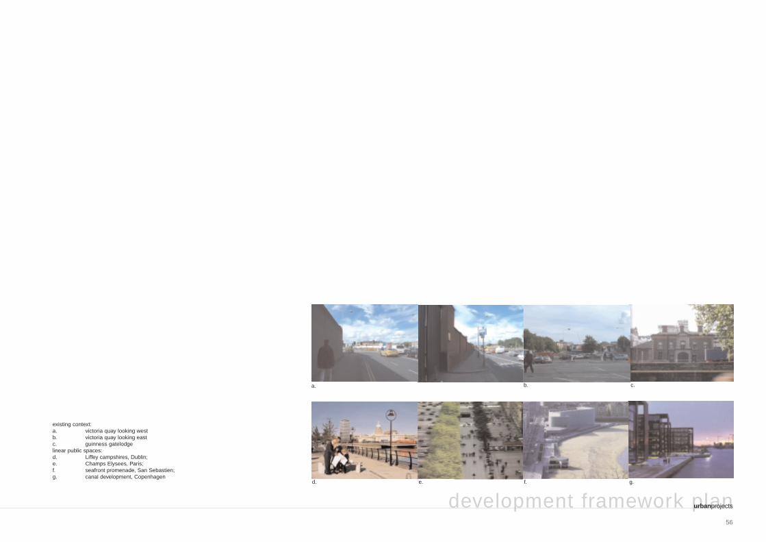
heuston gateway: regeneration strategy and development framework plan
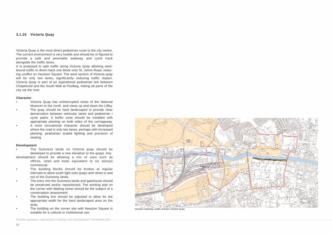
3.1.10 Victoria Quay
Victoria Quay is the most direct pedestrian route to the city centre.The current environment is very hostile and should be re-figured toprovide a safe and amenable walkway and cycle track alongside the traffic lanes.It is proposed to split traffic along Victoria Quay allowing west-bound traffic to divert back one block onto St. Johns Road, reduc-ing conflict on Heuston Square. The west section of Victoria quaywill be only two lanes, significantly reducing traffic impact.Victoria Quay is part of an aspirational pedestrian link betweenChapelizod and the South Wall at Poolbeg, linking all parts of the city via the river.
Character• Victoria Quay has uninterrupted views of the National
Museum to the north, and views up and down the Liffey.• The quay should be hard landscaped to provide clear
demarcation between vehicular lanes and pedestrian / cycle paths. A buffer zone should be installed with appropriate planting on both sides of the carriageway.
• A more recreational character should be developed where the road is only two lanes, perhaps with increased planting, pedestrian scaled lighting and provision of seating.
Development• The Guinness lands on Victoria quay should be
developed to provide a new elevation to the quays. Any development should be allowing a mix of uses such as
offices, retail and hotel equivalent to six storeys commercial.
• The building blocks should be broken at regular intervals to allow south light onto quays and views to and out of the Guinness lands.
• The entry into the Guinness lands and gatehouse should be preserved and/or repositioned. The exsiting pub on the corner with Watling street should be the subject of a conservation assessment
• The building line should be adjusted to allow for the appropriate width for the hard landscaped area on the quay.
• The building on the corner site with Heuston Square is suitable for a cultural or institutional use.
Heuston Gateway: public domain: Victoria Quay
56
development framework planurbanprojects
existing context:a. victoria quay looking westb. victoria quay looking eastc. guinness gatelodgelinear public spaces:d. Liffey campshires, Dublin;e. Champs Elysees, Paris;f. seafront promenade, San Sebastien;g. canal development, Copenhagen
c.
d. e. f. g.
a. b.

3.1.11 Parkgate Street
Parkgate Street is a key public space between the City Quays andPhoenix Park. The Park is presently not well connected to the cityfor pedestrians. The improvement of connections between keysites is an objective of the regeneration Strategy. The street is heavily trafficked and accommodates several bus routes. The Luaswill increase congestion on the street when it cuts across from theHeuston Bridge to Benburb Street. The north side of the street ischaracterised by numerous retail outlets including pubs, althoughsome uses, such as the car sales outlet, are considered in appro-priate.The south side of the street is dominated by impermeable wallssuch as those of the Hickeys site and office blocks.With possible increased traffic loading and congestion from Luasworks, it is essential that Parkgate Street is updated to allow forefficient traffic flow and management, safe and easily legiblepedestrian areas, and improved amenity in the public realm to pro-vide a quality environment to link the city with the park.
Character
• Animated street frontages to new development on Hickeys site.
• Wide pavement areas with high quality materials and lighting leading to safe and efficient crossings
• Direct access to river through new development
Associated Development
• The new development on the Hickeys site should be of the higest standard with a mix of uses
• Ground floor uses should be retail / commercial with high levels of transparency
heuston gateway: regeneration strategy and development framework plan
57
Heuston Gateway: public domain: Parkgate Street

development framework planurbanprojects
58
a. existing views of Parkgate Streetb. active streets, Francec. active streets, Berlin
a.
b. c.

59
3.2 Connections
In order to increase permeability through the site and connect withthe wider city, the Development Framework Plan proposes a seriesof connections throughout the study area. These connections are described as pedestrian / cycle, vehicular, and visual.
3.2.1 Pedestrian and cycle
High quality pedestrian and cycle environments should link allpublic spaces, amenity spaces and developments. This will significantly increase permeability through the large sites andcreate a multitude of routes connecting all points in the study area and city.The sense of the area being part of a transport corridor, with traffic dominating in an east-west direction, must be counteractedby this network of pedestrian routes and cycle lanes.
The principal proposed pedestrian and cycle routes across the Heuston Gateway are described below:
heuston gateway: regeneration strategy and development framework plan
Heuston Gateway: pedestrian and cycle connections