CHAPTER VIII Comments and Coordination
102
VIII-1 CHAPTER VIII Comments and Coordination The Missouri Department of Transportation (MoDOT) and the Federal Highway Administration (FHWA) have provided numerous opportunities for the coordination of the study of the reconstruction of I-64 from west of Spoede Road to west of Sarah Street with general public and resource agencies. This chapter summarizes the public involvement and agency coordination programs that have taken place during project development. A. Public Involvement The complexity of the project and the diverse interests within the study corridor made it clear that the I-64 Environmental Impact Statement (EIS) required a responsive public involvement effort. A public involvement plan had been developed as part of conceptual engineering and urban design planning activities that occurred prior to the initiation of the EIS activities. These activities are often described as “The New I-64” project. These activities were continued and expanded to be consistent with the EIS process. The Public Information & Outreach Office of MoDOT developed a detailed Public Involvement Plan (PIP) that outlined the various activities designed to meet the goal of communicating with the public and receiving regular feedback. There had been previous attempts to rebuild I-64, and there was a long history of discussion about the need for the project. 1. MEETINGS a. Subcorridor Advisory Committees Because of the length and complexity of the project, the corridor was defined by three subcorridors. The Greenway Subcorridor extends east from the Spoede Road interchange to just west of the McCutcheon Road Overpass. The Thruway Subcorridor extends from just west of the McCutcheon Road Overpass to the McCausland/Skinker/Oakland interchange. The Parkway subcorridor extends from the McCausland/Skinker/Oakland interchange to the corridor’s eastern edge west of Sarah Street. The first public open house was held in May 1999. At this meeting, the recommendations from the Major Transportation Investment Analysis (MTIA) were shown and discussed. The public was advised that MoDOT was moving forward with the recommendations into conceptual design. Several hundred people attended and there was extensive media coverage in print, radio and television. Comments from this meeting included concerns for personal property, locations of soundwalls, number of lanes proposed on I-64 and the location of MetroLink, the region’s light rail transit system. In August 2000, the subcommittee structure was introduced to the public at an open meeting at the St. Louis Science Center. Members of the public and interested stakeholders were invited to join three committees, one for each subcorridor. The scope of the initial meetings of the Subcorridor Advisory Committees included conceptual engineering of interchanges and urban design (UD) proposals. The Subcorridor Advisory Committees were intended to serve as intermediaries between the project team and the community. Committee members, who represented various community groups and institutions, were asked to bring the concerns of their constituents to the project team and in turn, share information about the project with their
Transcript of CHAPTER VIII Comments and Coordination

VIII-1
CHAPTER VIII
Comments and Coordination
The Missouri Department of Transportation (MoDOT) and the Federal Highway Administration (FHWA) have provided numerous opportunities for the coordination of the study of the reconstruction of I-64 from west of Spoede Road to west of Sarah Street with general public and resource agencies. This chapter summarizes the public involvement and agency coordination programs that have taken place during project development. A. Public Involvement
The complexity of the project and the diverse interests within the study corridor made it clear that the I-64 Environmental Impact Statement (EIS) required a responsive public involvement effort. A public involvement plan had been developed as part of conceptual engineering and urban design planning activities that occurred prior to the initiation of the EIS activities. These activities are often described as “The New I-64” project. These activities were continued and expanded to be consistent with the EIS process. The Public Information & Outreach Office of MoDOT developed a detailed Public Involvement Plan (PIP) that outlined the various activities designed to meet the goal of communicating with the public and receiving regular feedback. There had been previous attempts to rebuild I-64, and there was a long history of discussion about the need for the project. 1. MEETINGS
a. Subcorridor Advisory Committees
Because of the length and complexity of the project, the corridor was defined by three subcorridors. The Greenway Subcorridor extends east from the Spoede Road interchange to just west of the McCutcheon Road Overpass. The Thruway Subcorridor extends from just west of the McCutcheon Road Overpass to the McCausland/Skinker/Oakland interchange. The Parkway subcorridor extends from the McCausland/Skinker/Oakland interchange to the corridor’s eastern edge west of Sarah Street. The first public open house was held in May 1999. At this meeting, the recommendations from the Major Transportation Investment Analysis (MTIA) were shown and discussed. The public was advised that MoDOT was moving forward with the recommendations into conceptual design. Several hundred people attended and there was extensive media coverage in print, radio and television. Comments from this meeting included concerns for personal property, locations of soundwalls, number of lanes proposed on I-64 and the location of MetroLink, the region’s light rail transit system. In August 2000, the subcommittee structure was introduced to the public at an open meeting at the St. Louis Science Center. Members of the public and interested stakeholders were invited to join three committees, one for each subcorridor. The scope of the initial meetings of the Subcorridor Advisory Committees included conceptual engineering of interchanges and urban design (UD) proposals. The Subcorridor Advisory Committees were intended to serve as intermediaries between the project team and the community. Committee members, who represented various community groups and institutions, were asked to bring the concerns of their constituents to the project team and in turn, share information about the project with their

VIII-2 The New I-64 Final Environmental Impact Statement constituents. The input provided by Subcorridor Advisory Committee members was used to develop conceptual alternatives and provide input to the EIS process. Meetings with the committees were held at regular intervals throughout the autumn and spring of 2000, 2001, 2002 and early in 2003. Possible alternative interchange designs were presented and discussed. The Greenway Committee met at the Transportation Information Center (TIC) of the Missouri Department of Transportation (MoDOT) in Chesterfield. The Thruway Committee met first in the basement of the Richmond Heights City Hall, then in rooms at the newly constructed Richmond Heights Community Center. The Parkway Committee met at first in the conference rooms of Forest Park Hospital, then in the McDonnell Conference Center of the Saint Louis Zoo. The subcommittee meetings were open to the public and were attended frequently by non-committee members. The meetings’ discussions and design concept options were covered regularly with articles in the St. Louis Post-Dispatch and Suburban Journal. Summaries of the meetings were posted on the project website. A brief synopsis of these meetings is contained in Appendix J in the Chronologies of I-64 Documentation. All concept options were displayed on the project website. At subcorridor meetings, members were usually given maps and drawings of interchange conceptual designs, as well as charts and graphs showing traffic volumes and other pertinent information.
Table VIII-1 Greenway Subcorridor Members
Dan Apted President, Ladue Place Don Beimdiek Brentwood Economic Development Council Fred Berger City Attorney, City of Westwood Mike Bush Representative, Salem United Methodist Church Barbara Clements Alderwoman, York Hills John Conroy Resident Carolyn Cummings Resident, York Village Quintus L. (Bud) Drennan, Jr. Resident, Godwin Lane Association
Lori Fiegel Manager, Comprehensive Planning St. Louis County Planning Department
Catherine Hanaway State Representative, District 87 John Harlan Representative, Trail’s End Subdivision Irene S. Holmes Councilwoman, Ward 2, Ladue Mary Fran Horgan Resident Thomas M. Horgan Resident Ken Krueger Trustee President, Ladue Ridge Road Subdivision Doyt Ladd Treasurer, Ladue Crest Lane Association Annette Mandel Mayor, Creve Coeur Robert Matzke Resident Mark Mihalevich Resident Geoffrey Morrison Trustee, Briarwood Subdivision Jack Perry President Trustee, Richmond Hills Subdivision Pete Peterson Representative, Salem United Methodist Church Ray Potter Subdivision Trustee, Clayton Road Park Chuck Schierer Alderman Sandy Sobelman Mayor, City of Frontenac Michael Wooldridge City Clerk, City of Ladue

CHAPTER VIII – Comments and Coordination VIII-3
Table VIII-2 Thruway Subcorridor Members
David Alexander Resident Debra Behrendt President, Brentwood Forest Condominium Association Andrew Bell Resident
Dennis W. Bice Community Liaison Supervisor St. Louis County Dept. of Highway & Traffic
Joan Bray State Representative, District 84 R. Lee Cannon Associate Traffic Engineer – Crawford, Bunte, Brammeier Marisa Chambers Trustee, Hampton Park Subdivision Tim Day Resident Jerry Ebest Director of Real Estate, Dierberg Markets
Joan Esserman Chair, Local Government Committee League of Women Voters
James or Pat Finger Resident Matt Fister Chairman, Hanley Downs Board of Trustees Beverly Fogelman Hanley Downs Board of Trustees Stephen Fons Council Member, City of Richmond Heights Andrew Franke Church of Little Flower John W. Geppert Truman Bank Virginia Harris Sierra Club Kathy Holman Former Trustee, Lake Forest Subdivision Steve Hoven Vice President Public Affairs, SSM Health Care Betty Humphrey Mayor, City of Richmond Heights Francis Kenney Mayor, City of Clayton John Kraska President, Hanley Court Industrial Assoc. Juliana Lally Gissler Avenue Association Rev. Nathaniel Malone Pastor, First Baptist Church of Maplewood Jan Mangelsdorf Resident Joellen G. McDonald Co-Chair, Richmond Heights Transportation Board Michael S. McGrath Resident, Richmond Heights Transportation Board Rich Moffit Resident John Openlander Public Works Director, City of Maplewood Alice Provaznik Richmond Heights Transportation Board Scott Randall City Manager, City of Clayton Georgia Rusan Resident Michael Schoedel City Manager, City of Richmond Heights Julia Schulte Resident Bob Shelton Economic Development Director, Brentwood Morris H. Sterneck Executive Vice President, Hycel Properties Co. James Thomson Resident
Tina M. Votaw Division Director, Real Estate & Development Bi-State Development Agency - MetroLink
Joyce Walsh Trustee, Hampton Park Neighborhood Kevin Ward Transportation Engineer, Federal Highway Administration
Table VIII-3
Parkway Subcorridor Members
Judy Alexander Director of Administration and Finance, Central Institute for the Deaf
Garrett A. Balke Chairman and CEO, Balke Brown Associates Robert Bannister Principal, St. Louis University High School Jim Belval Facilities Director, BJC Health System Joann Berger Treasurer, Hi-Pointe Residents Association S. Mitchell Bowers President, Hi-Pointe Residents Association Paul Brockmann Director of General Services, Missouri Botanical Garden Edward L. Cody Attorney at Law
Frederick Douglas Manager, Service Development Planning Bi-State Development Agency
Derio Gambaro State Representative, District 65

VIII-4 The New I-64 Final Environmental Impact Statement
Jack Gillum Adjunct Professor, Washington University Susan Glassman Urban Strategies Melvin Leon Hall President, CEO, Chairman, Lindell Bank Robert Hilgeman State Representative, District 64 Christine Ivcich The Muny, Forest Park Lyda Krewson Alderman, Ward 28 Frank or Dorothy Mead President, Citizen Patrol Kevin Mills Director of Marketing, Saint Louis Zoo R. Mark Odom District Director, Office of Congressman Clay Marcella Palmieri Southeast Housing Corp. Bill Peick VP, Construction and Property Management, Tenet Healthcare John Raniero President, Cheltenham Neighborhood Association Norm Shipley Project Director, BJC Health Systems Ronald C. Smith Acting President, St. Louis Community College at Forest Park Connie Tomasula St. Louis Planning Agency Elaine Torres Resident John Wharton Senior Director of Operations, St. Louis Science Center Brian M. Wilson Neighborhood Stabilization Officer, City of St. Louis Tom Yarbrough Bicycle Program Manager, Trailnet
b. Aesthetic Advisory Committee
Project leaders intended to use The New I-64 as an opportunity to offer aesthetic enhancements to the highway, many of which could be incorporated with minimal budget impact. To this end, a separate Aesthetic Advisory Committee was formed. Half of its members were drawn from the Subcorridor Advisory Committees, and half were professionals in urban design, art, and architecture from the St. Louis community. The Aesthetic Advisory Committee’s first meeting was held at MoDOT’s Transportation Information Center in Chesterfield on October 25, 2000. The Aesthetic Advisory Committee was given three roles: to assist in developing the words and images that would define an aesthetic theme for The New I-64; to provide direction to the Subcorridor Advisory Committees; and to help choose two design collaboration artists, one from St. Louis and one from outside the region, from a list developed by MoDOT consultants. These two artists would not execute commissions directly themselves, but would serve on the Aesthetic Advisory Committee, help choose the aesthetic theme, and work with commissioned artists on specific projects on various elements of the highway, bridge, and walkway, and landscaping designs, to make sure that individual commissions reflected the aesthetic theme. On October 25, 2000, three St. Louis artists, selected from a short list developed by a project consultant, were interviewed by the project team. On November 17, 2000, the three—Phil Robinson, Janet Sanders, and Ron Fondaw—gave presentations to the Aesthetic Advisory Committee. On January 9, 2001, two artists from outside the St. Louis area, Valerie Otani and Leila Daw, gave presentations to the Aesthetic Advisory Committee (A third candidate, Patrick Suchard, withdrew his name from consideration.) After consulting with the Aesthetic Advisory Committee, the project team announced on January 11, 2001 the selection of the two design collaboration artists, Phil Robinson and Valerie Otani. On November 30, 2000, the Aesthetic Advisory Committee met to begin choosing the aesthetic theme for The New I-64. Members examined an “image bank” of photographs of buildings, landmarks, monuments and residences in the St. Louis region that reflected St. Louis’s aesthetic history. The group developed an urban design theme that would seek to utilize traditional materials (brick and stone), existing St. Louis architecture (art deco images on current I-64 bridges), and native vegetation as part of I-64 reconstruction. This theme was presented to the Aesthetic Advisory Committee in March 2002 and was well received. It was presented to the public at an open house on April 3, 2002, and was included in the January 29, 2003 Public Hearing.

CHAPTER VIII – Comments and Coordination VIII-5
Table VIII-4 Aesthetic Advisory Committee Members
Michael Byron Associate Professor of Art, Washington U. Esley Hamilton Preservation Sites Historian St. Louis County Parks and Recreation Catherine Hanaway* (*withdrew autumn 2001) State Representative, District 87 (Greenway) Christine Ivcich The Muny at Forest Park (Parkway) Dick Kirschner* (*withdrew Spring 2002) Principal, Mackey Mitchell Associates Ken Krueger Trustee President, Ladue Ridge Road Subdivision (Greenway) Irv Logan Missouri Dept. of Conservation Betsy Millard Executive Director Forum for Contemporary Art Valerie Otani Project Artist Phil Robinson Project Artist Michael Schoedel City Manager, Richmond Heights (Thruway) Jacqueline Tatom Associate Prof. of Architecture Washington University Joyce Walsh Trustee, Hampton Park Neighborhood
c. Public Meetings
The kickoff meeting for The New I-64 was held on May 27, 1999 in the lower level of the Richmond Heights library. At this meeting, the public was shown the recommendations from the MTIA approved by the region’s metropolitan planning organization in 1997. The public was informed that the conceptual design was beginning and their input was valued. A second public meeting was held August 30, 2000. At this meeting, the three Subcorridor Advisory Committees were created as one method to provide public and stakeholder input into the project. An open-house public meeting for the EIS was held on April 3, 2002. Its purpose was to obtain input from the community, to explain the role of the Environmental Impact Statement (EIS) in the project, present and obtain input on the process used to identify and refine the alternatives being studied in the EIS, and to present visual information on the progress of ideas for aesthetic treatments of design elements. The Public Open House was held in three rooms of the Richmond Heights Community Center from 2 p.m. through 8 p.m. It was publicized through press releases to local media and a mass mailing. Approximately three hundred people attended, including many who were introduced to the project for the first time. Feedback forms were provided. The meeting was previewed by the St. Louis Post-Dispatch and the local Fox TV affiliate in the days prior to the meeting. The meeting itself was covered by all the major media in St. Louis including the St. Louis Post-Dispatch, Suburban Journal, KMOX, KTRS and KWMU radio and all four TV stations. Comments from the April 3, 2002, meeting included support for the need for the project, concerns about personal property, the need for sound walls throughout the corridor, support for the proposed aesthetics, concern about traffic flow at various interchanges, and concern about some of the options a the I-170 interchange. Comments were received from people requesting that property impacts be minimized and urging selection of the option that impacted them the least. The public hearing provided an opportunity for the public to view the Draft EIS and project concepts. There was also an opportunity to make comments and have them considered in the NEPA process. Any substantive comments are addressed in this Final EIS for I-64.

VIII-6 The New I-64 Final Environmental Impact Statement d. Forest Park Stakeholder Meetings
Forest Park presented special challenges. In the summer of 2001, the I-64 team held a series of meetings with city of St. Louis officials and Forest Park stakeholders, many of whom also sit on the Parkway committee. Specific participants included the St. Louis Zoo, Forest Park Community College, Balke properties, BJC Hospital, Forest Park, and the St. Louis Development Corporation (part of the city of St. Louis). Meetings were held in the first-floor conference room of the Equitable Building in downtown St. Louis. Issues discussed by the team included possible impacts of I-64 reconstruction to Forest Park property; the design of the Hampton interchange; landscape treatments of Oakland Avenue; plans by St. Louis Community College to improve its curbside appearance; pedestrian walkways and handicapped accommodations along and across Oakland; plans by St. Louis Community College to improve its curbside appearance; possible impacts of the project to the Saint Louis Zoo parking lot; and the relocation of the pedestrian tunnel under I-64. The project team’s conceptual design reflects this collaborative effort on these issues. A brief synopsis of these coordination meetings is included in the Section 4(f) Evaluation, F. Coordination Summary. e. Meetings and Communications with Public Officials
The project team identified a number of public officials who may have an interest in the project’s outcome. Beginning in 1999, members of the I-64 project team began a series of ongoing meetings with elected officials, business leaders, and other stakeholders along the I-64 corridor. These were usually held at the request of municipalities or other groups that asked project team members or leaders to give presentations about the project. The purpose of these meetings was to present the latest conceptual designs to specific municipalities or other groups, and to hear concerns specific to those designs or proposals. Meetings are further detailed in the Project Chronology located in Appendix J.
Table VIII-5 Elected Officials on I-64 Mailing List
Rep. Todd Akin Tom Bauer, Alderman, 24th Ward Paula Carter, State Senator, District 5 Marit Clark, Alderwoman, 6th Ward Rep. William Clay, U.S. District 4 Rep. William Clay Jr., State Representative, District Senator Patrick Dougherty, Missouri District 4 Nancy Greenwood, Mayor, Chesterfield Catherine Hanaway, State Representative, District 87 (Greenway) Robert Hilgeman, State Reprentative, District 6 (Greenway) Betty Humphrey, Mayor, Richmond Heights (Thruway) Lyda Krewson, Alderwoman, 28th Ward (Parkway) David Levin, State Representative, District 82 Annette Mandel, Mayor, Creve Coeur (Greenway) Dan McGuire, Alderman Mike Schoedel, City Manager, Richmond Heights (Thruway) Pat Secrest, State Representative, District 82 Betty Sims, State Representative, District 24 Francis Slay, Mayor, City of St. Louis Buzz Westfall, County Executive, St. Louis County
From August 2001 to November 2001, the project team met regularly with a group of elected officials to discuss their concerns and provide updates on the project team’s conceptual design work. This group included the mayor or designated representative from each municipality on the corridor, as well as the state representatives and senators representing the corridor. After

CHAPTER VIII – Comments and Coordination VIII-7
this series of meetings, the group felt its specific project issues were being addressed and MoDOT was being attentive to the issues of the community. Communication with this group took place through project newsletters and updates. f. Other Meetings
The Missouri Department of Transportation was invited to speak and attended several hundred other meetings in the community along the corridor from 1999 through 2004. These meetings included neighborhood associations, informal neighborhood groups, chambers of commerce, groups of realtors, elected official town hall meetings, property developers and individual meetings. A meeting was held with Paraquad, to discuss issues relating to access for the disabled. Meetings held are listed in the Project Chronology in Appendix J. 2. THE NEW I-64 WEBSITE
The New I-64 project team commissioned an innovative website that came online in October 2000. The New I-64 website contains sections that show maps and conceptual designs distributed at Subcorridor Advisory Committee meetings. Another website section allows the public to post comments directly to the MoDOT Project Manager and receive replies. Website visitors who provided mailing information were added to the project mailing list. By the spring of 2002, approximately two thousand people had left their names and mailing information on the web mailing list. 3. PROJECT NEWSLETTERS
Five project newsletters and six update letters were produced, in June 2000, December 2000, February 2001, July 2001, August 2001, September 2001, October 2001, March 2002, June 2002, January 2003 and December 2003. The first newsletter was two-color; the other four were four colors to better convey graphic information. The six update letters were one or two-page summaries to inform the public on the project status. All were mailed to the mailing list and distributed at meetings of the Subcorridor Advisory Committees. Bundles of newsletters were also given to municipal entities for placement and distribution at public sites. The newsletters and letters were mailed to nearly 2,000 people on the project mailing list and were posted on the project website. 4. MEDIA
Providing information to the local residents, local business owners and regional interests regarding project process, project progress and opportunities for input was an important step in developing the EIS. To accomplish this, a number of different outlets were identified for reaching the public. The Missouri Department of Transportation’s Public Information Office periodically issued press releases when project decisions or milestones were reached. Meetings of the Subcorridor Advisory committees were regularly covered by the St. Louis Post-Dispatch, St. Louis’s metropolitan daily newspaper. Newspaper articles referring to The New I-64 reconstruction are listed and included in the Project Chronology. The St. Louis Post-Dispatch has covered the project team’s conceptual designs in detail over the last four years. Articles have shown maps of the options and included information on the topics debated as the I-64 team refined its concepts. Several local TV news organizations also reported on Subcorridor Advisory Committee meetings, and I-64 project team leaders were interviewed on-site during a Thruway meeting for a PBS special on community involvement in local political issues. Additional publications that were available to inform the public about the draft EIS included:
• Church newsletters, which are published by some of the neighborhood churches and are available to those local populations during religious services.

VIII-8 The New I-64 Final Environmental Impact Statement
• The St. Louis American (Stlamerican.com), The St. Louis Metro Sentinel (Stlsentinel.com), St. Louis Argus and Take Five are newspapers and publications that focus on the African-American community. Also, the Organization for Black Struggle occasionally publishes and distributes a newsletter.
• The West End Word (stlcriticalmass.org/media/west_end_word.htm) is a religious
publication and provides a communication mechanism with minority communities and neighborhoods of the study corridor.
• The Scene (Fp.stlcc.cc.mo.us/scene) is a small newspaper published and distributed six
times a semester through Forest Park Community College.
• St. Louis Chinese American News (Scanews.com) and St. Louis Chinese Journal (Every-day.net) are two newspapers that are published for readers of Asian-Chinese descent in St. Louis.
• Red Latina and Que Pasa (Quepasastl.com) are biweekly and monthly Hispanic
publications, respectively. Both are distributed throughout St. Louis and were found in the Parkway Subcorridor neighborhoods. Both publications are owned by the Hispanic Media Group in St. Louis. The organization also produces a weekly Spanish-speaking television show entitled “Enterate” on KPLR, Channel 11. Other resources to reach Hispanic communities in St. Louis include radio such as "Alma Latina" program on the noncommercial station KDHX 88.1 FM and WEW 770 AM hosts the program “Radio Cucui.”
• St. Louis Post Dispatch (Stltoday.com) publishes suburban journals in the Bosnian
language. 5. PROJECT VIDEOS
As part of its public involvement strategy, MoDOT commissioned videos on topics of particular interest to residents living near the I-64 project corridor. The videos were shown at subcorridor advisory committee meetings, at the April 3 public open house, and at various other meetings. One video explained the single-point urban interchange, a type of interchange design proposed for many I-64 interchanges. Another dealt with issues surrounding sound walls and noise mitigation, a topic of great interest to homeowners immediately adjacent to the highway. 6. SUMMARY OF PUBLIC COMMENTS RECEIVED PRIOR TO THE DRAFT EIS
Comments on proposed I-64 conceptual designs were received through a number of media. Letters from interested members of the public were received by a designated contact person, who either responded or passed them on to the appropriate team leaders. Comments were posted to the I-64 website and responded to by project leaders; a summary of the web comments and comments from the public information meeting are included in Appendix J. Numerous public comments were gathered prior to the release of the DEIS. The majority of those comments were in favor of improvements to I-64 and the quick completion of those improvements. The comments in favor of improving I-64 were particularly interested in increased capacity, improving the flow of through traffic and improving the interchanges. Of these comments received, many also expressed opposition to improvements which would take residential property. This is particularly true for the Brentwood Boulevard/I-170/Hanley Road/Galleria Parkway interchange. There were comments indicating preferences for Option 1,

CHAPTER VIII – Comments and Coordination VIII-9
Option 2a and Option 3. The main concern expressed in the public comments regarding this interchange were the impacts on residential property. Residents of the Brentwood Forest Condominiums were very opposed to any of the options that would require improvements to the south of the existing alignment because this would require the taking of the Town & Country apartment complex. The taking of the Town & Country apartments would move the interstate closer to the condominiums and would have consequences on the noise level and views of those residents. The use of Option 2 along I-64 received support because the footprint required for the roadway would be smaller and there would be less impacts to property along the corridor. Some individuals preferred Option 3 to Option 2 because they felt that the stacked interstate would be built at a height above that of their property and those property owners were not only concerned about the increase in noise but also in the impact to their view and their property values. It was pointed out by MoDOT staff at numerous meetings and through returned phone calls that the elevation of the stacked alternative would not be different than the current elevation of I-64. A few of the comments were concerned only with the impact to their property value in terms of the appearance of the improvements. There were also some comments by residential property owners whose homes would be taken by one or more of the options and they preferred the option or options which would not affect their property for that reason only. Other comments relayed the concern for noise impacts and the need to retain trees that would act as noise and view barriers and the need to build sound walls. The majority of those individuals commenting asked that sound walls be constructed to minimize the noise from traffic on I-64 and be used as an aesthetic element to improve the look of the corridor. Some of the comments expressed the desire to eliminate a few of the interchanges in order to improve traffic flow. One of these comments was specific to the optional Oakland interchange, saying that this interchange was not needed because access was provided elsewhere. Along this same line, a few comments expressed concerns about impacts to residential streets either during construction, for example at the Spoede and I-64 interchange, and after construction if the ramp configurations are changed, as has been proposed for the McCausland interchange. Another comment suggested that the ramps from I-64 to I-170 north be improved to two lanes to better handle the flow of traffic at that interchange. One comment suggested that traffic signals be installed at the Kingshighway interchange to accommodate turning movements onto I-64. A traffic signal is included as part of the recommended single point interchange design. One of the interchanges that received a considerable number of comments on the website was Bellevue Avenue and the access there for St. Mary’s hospital. The majority of the comments asked that this access be kept open while a few felt that there was insufficient traffic to warrant the interchange and that the interchanges in that area are too close together. Comments related to maintaining Big Bend as a half interchange were also received. A related comment was the concern that pedestrian access would be eliminated or reduced and that bus stops would not be accommodated because of improvements and stressing the importance of these considerations. Several comments were received via the website relating to the importance of the availability of pedestrian and bicycle access connecting the neighborhoods and Forest Park, in particular.
VIII-10 The New I-64 Final Environmental Impact Statement
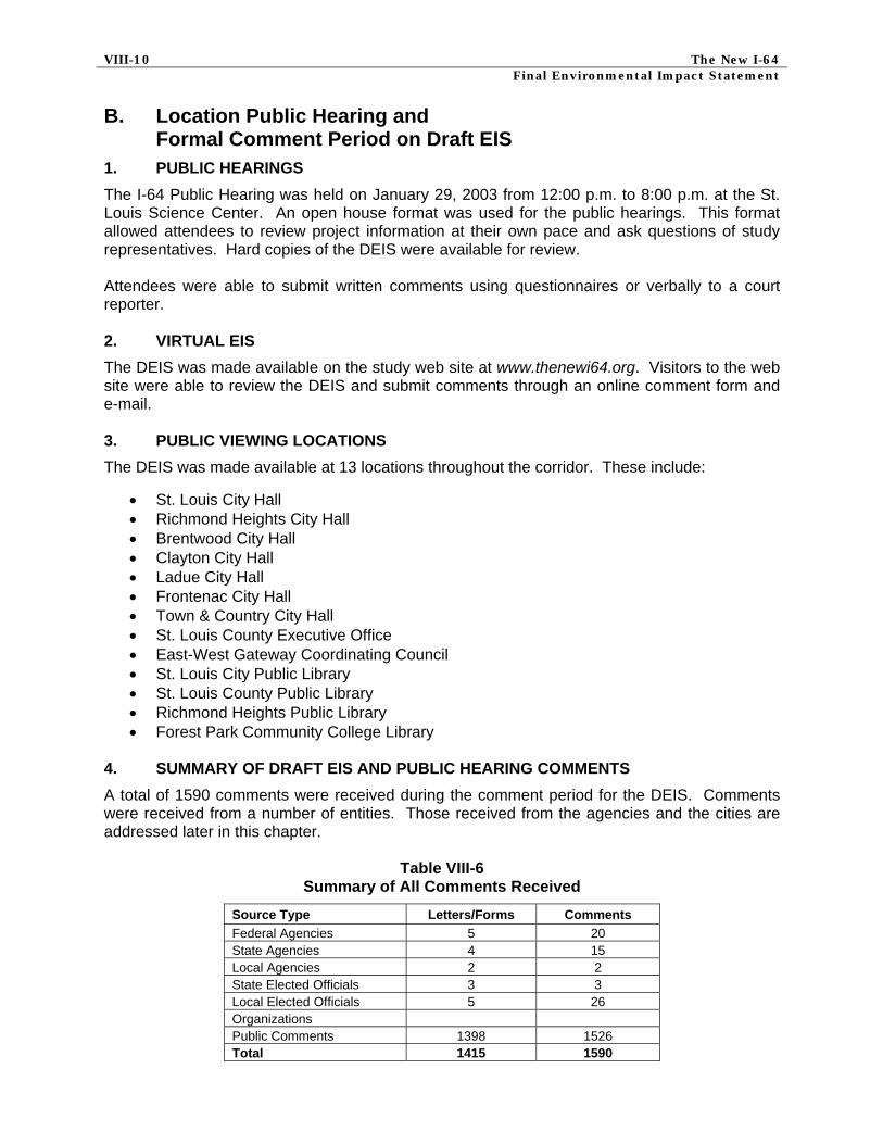
B. Location Public Hearing and Formal Comment Period on Draft EIS
1. PUBLIC HEARINGS
The I-64 Public Hearing was held on January 29, 2003 from 12:00 p.m. to 8:00 p.m. at the St. Louis Science Center. An open house format was used for the public hearings. This format allowed attendees to review project information at their own pace and ask questions of study representatives. Hard copies of the DEIS were available for review. Attendees were able to submit written comments using questionnaires or verbally to a court reporter. 2. VIRTUAL EIS
The DEIS was made available on the study web site at www.thenewi64.org. Visitors to the web site were able to review the DEIS and submit comments through an online comment form and e-mail. 3. PUBLIC VIEWING LOCATIONS
The DEIS was made available at 13 locations throughout the corridor. These include:
• St. Louis City Hall • Richmond Heights City Hall • Brentwood City Hall • Clayton City Hall • Ladue City Hall • Frontenac City Hall • Town & Country City Hall • St. Louis County Executive Office • East-West Gateway Coordinating Council • St. Louis City Public Library • St. Louis County Public Library • Richmond Heights Public Library • Forest Park Community College Library
4. SUMMARY OF DRAFT EIS AND PUBLIC HEARING COMMENTS
A total of 1590 comments were received during the comment period for the DEIS. Comments were received from a number of entities. Those received from the agencies and the cities are addressed later in this chapter.
Table VIII-6 Summary of All Comments Received
Source Type Letters/Forms Comments Federal Agencies 5 20 State Agencies 4 15 Local Agencies 2 2 State Elected Officials 3 3 Local Elected Officials 5 26 Organizations Public Comments 1398 1526 Total 1415 1590

CHAPTER VIII – Comments and Coordination VIII-11
a. General Summary of Public Comments
About half of the comments submitted during the formal comment period were of a general nature. Table VIII-7 presents and categorizes consistent comments and themes received from the public in review of the DEIS.
Table VIII-7 Summary of Consistent General Comments
General Public Comment Count 1. Concerns about property owners being held in limbo due to the right-of-way acquisition timeframe 11
2. Concern that changes to I-64 will affect property values 14 3. Concern about the number of homes being taken 23 4. Concern about the acquisition of all or part of specific properties 45 5. Concern that property owners will not be adequately compensated 7 6. Concern that adequate replacement housing will not be affordable or available in current neighborhood 4
7. Concern about children being removed from the Clayton school district 5 8. Concerns about drainage on the highway and the runoff on nearby properties 6 9. Concern about the lack of MetroLink in the corridor 3 10. Make the additional lane an HOV lane 1 11. Bicycle riders need lanes on all crossover bridges 3 12. Bicyclists need design which will allow for wide outer lanes and long enough signal cycles to allow cyclists to flow with traffic and for pedestrians to cross the intersections safely.
1
13. Separate bicycle and pedestrian traffic from the interchanges 1 14. Supportive of the urban design/aesthetic portion of the project 6 15. Concern about the view from homes if I-64 is raised 6 16. Try to leave as many trees and green space as possible 2 17. Use right-of-way leftover from converted clover leaf interchanges for city parks 1 18. Concern about the replacement of landscaping/trees on private property that would need to be removed for construction 2
19. Replace narrow sidewalk over Deer Creek at Clayton Road and Warson 1 20. Consider adding a memorial to Charles Lindbergh at the I-64 and Lindbergh interchange 1
21. Concern about the level of lighting 4 22. Desire to have noise walls constructed 16 23. Concern that noise walls won’t work and will obstruct views 5 24. Noise walls should be built prior to construction 3 25. Concern about the effects of vibration 1 26. The project is encouraging urban sprawl 2 27. Provide brighter reflectors and striping for visibility 1 28. Provide a barrier between oncoming traffic that is high enough to shield drivers from headlights 1
29. Concern about a fault line that runs through neighborhood and may do damage if hit during construction 1
30. Reduce congestion on northbound Kingshighway leading into the BJC complex and its parking 1
31. Improve alternate routes prior to construction on I-64 to reduce delays 1 32. Roundabouts are too complicated/ are a good solution 2 33. MoDOT should keep people informed of the construction schedule and delays 2

VIII-12 The New I-64 Final Environmental Impact Statement
General Public Comment Count 34. MoDOT should adopt a construction schedule to complete intersections as separate projects 2
35. Concern that MoDOT is choosing the most expensive alternative 1 36. Consider turning portions of I-70 and I-44 into toll roads to pay for the project 1 37. General supportive comments 20
The following general comments indicate concerns that were shared frequently by individuals and public agencies who contacted the study team through various means. These issues and concerns were not the product of a scientific survey and do not necessarily reflect the issues and concerns of a wider audience. The following generalized comment categories received were reviewed and considered as part of this EIS.
• Concern about property owners being held in limbo due to the right-of-way acquisition timeframe – Due to the unknown timeline and the lack of funds to begin the improvements, property owners are being held in limbo as to the actual impacts to their property and the timeframe for making acquisitions.
Response: Property that is noted as being acquired for a MoDOT project in an Environmental Impact Statement may concern property owners, especially when timing of project implementation is not precisely known. The New I-64 Improvement is a multi-year project and right-of-way will be acquired over a number of years. To address immediate concerns about property acquisition, the MoDOT right-of-way specialists can consider hardship acquisitions when so requested by the property owner and approved by MoDOT’s Central Office and FHWA. This can allow property owners who must move for one reason or another to have their property acquired by MoDOT ahead of the usual acquisition procedure timeframes. Additionally, improvements made to the property in the interim period, between Record of Decision and Project Implementation, are figured into the appraised valuation of the property. Additional information can be found in Chapter IV, Section C. Right-of-Way Impacts.
• Concern that changes to I-64 will affect property values – The changes to I-64 are
causing a decrease in property values that affect the ability to sell a property and a concern about the method for compensating property owners, particularly for those properties that MoDOT is not purchasing but that will be affected by the changes.
Response: MoDOT has found over the years, that there is no fixed rule about changes in property values due a highway project being redesigned, such as the New I-64. Some properties may experience an increase in valuation, due to improved access, or visibility. Other properties may experience no change or could decline in their apparent valuation or desirability in the real estate market. There are numerous factors which go into making a particular property valuable or desirable within the real estate market and proximity to transportation corridors is just one factor. Efforts have been made to enhance property values by providing for urban design treatments. Improved pedestrian access, noise attenuation, open space, and landscaping are all part of the proposed action to not only mitigate but enhance the existing neighborhoods, commercial areas and public facilities. More information can be found in Chapter IV, Section C. Right-of-Way Impacts and Chapter V Urban Design.
• Concern about the number of homes being taken – The impacts to the homes in the
corridor, particularly in Richmond Heights are too numerous especially since this area has already been impacted numerous times in the past by highway expansion.

CHAPTER VIII – Comments and Coordination VIII-13
Response: Efforts have been made to minimize impacts to residences. A key criteria of the project is to minimize property impacts. Strategies utilized to minimize property impacts include use of retaining walls and minimizing cut and fill sections. Even with these design strategies, a number of residences would be taken. Property impacts are described in Chapter IV, Section C. Right-of-Way Impacts.
• Concern about the acquisition of all or part of specific properties – Questions were
raised about the extent of the exact impact to specific properties within the I-64 Study Corridor and whether these would be total or partial acquisitions.
Response: The EIS identifies potential property impacts of the refined alternatives. A total taking is indicated if the entire property is included in the property impacts. A partial taking is indicated if a portion of the property is included in the property impacts. The potential property impacts are indicated in conceptual engineering plates shown in Appendix C. A more specific assessment of property impacts will be completed as part of more detailed engineering in subsequent study and be available for public review at a design public hearing as further engineering is completed.
• Concern that property owners will not be adequately compensated – The concern
is that property owners will not be adequately compensated for the impacts to their property.
Response: MoDOT uses prescribed procedures in accordance with the Uniform Relocation Assistance and Real Property Acquisition Act of 1970, as amended. This act requires that just compensation be paid to the owner of private property taken for public use. The right-of-way specialists utilize professional appraisers who are familiar with the neighborhoods and local market conditions to ascertain the fair market value of the property to be acquired. If the property owner is not satisfied with the offer, they make a counter offer to the right-of-way specialist. If the right-of-way specialist and the property owner are still unable to reach an agreement, the matter can be submitted to a third party mediator, at no cost to the property owner. The mediator can often find agreement and negotiate a valuation that the property owner can accept. However, should the mediation efforts not produce an agreement, the property owner can choose to take it to court.
• Concern that adequate replacement housing will not be affordable or available in
the current neighborhood – Homeowners are concerned that they will not be able to find housing within their current neighborhoods because there won’t be any available and they won’t be able to afford what is there.
Response: The EIS does indicate that in certain locations in the I-64 corridor the number of housing units currently for sale within the general area of the acquisitions appeared to be inadequate to meet anticipated demand. However, it should be noted that improvements to the New I-64 will be phased over several years and not all of the replacement housing will need to be available at the same time. Throughout the project, the right-of-way specialists will be working with individual property owners to obtain replacement housing that meets their needs. Relocation assistance payments are designed to compensate displaced persons for costs that have been imposed on them by a MoDOT project. A displaced owner-occupant may be eligible to receive up to $22,500 for a replacement housing payment. This includes the amount by which the cost of a replacement dwelling

VIII-14 The New I-64 Final Environmental Impact Statement
exceeds the acquisition cost of the displacement dwelling, increased interest costs and incidental costs. Should this project include persons who cannot readily be moved using the relocation program benefits and/or procedures, i.e., when there is a unique housing need or when the cost of available comparable housing would result in payments in excess of statutory payment limits, the MoDOT’s relocation policy commits to utilizing housing of last resort. Housing of last resort involves the use of payments of statutory maximums or the use of other unusual methods of providing comparable housing. The Uniform Act requires that comparable, decent, safe and sanitary replacement housing within a person’s financial means be made available before that person may be displaced.
• Concern about children being removed from the Clayton School District – The children in those homes that are being acquired will not be able to continue to attend Clayton School District because the homeowners won’t be able to find replacement housing that is affordable within the school district.
Response: Within the framework of relocation policies, MoDOT has the ability to take into account issues that contribute to the real estate value of the property to be acquired. The appraisal valuation takes into account school districts in regard to their contribution to the overall value of a property. Specifics about an individual property valuation is beyond the scope of an Environmental Impact Statement document and this information is developed at the time the property is appraised and then acquired by MoDOT. Items such as this are an integral part of the right-of-way negotiation process. The analysis conducted as part of the EIS, indicated that some of those displaced would have to relocate to other communities in the metro area. See Chapter IV, Section C. 3. MoDOT offers a relocation assistance program to individuals, families, business owners, farm operators, and non-profit organizations that are partially or totally displaced by a state highway project. Relocation assistance payments are designed to compensate displaced persons for costs that have been imposed on them by a MoDOT project. Any displaced owner-occupant or tenant of a dwelling who qualifies as a displaced person is entitled to payment of his or her actually moving and related expenses, as MoDOT determines to be reasonable and necessary. Reasonable expenses can include the cost or a portion of the cost of out of district educational tuition fees that may be assessed.
• Concern about drainage on the highway and the runoff on nearby properties –
Erosion due to runoff is causing, property owners adjacent to I-64, problems which are getting worse as time goes on and there is concern about the amount of water that collects on the highway when it rains.
Response: The design of the project must be accomplished in a way that there will not be drainage impacts to nearby properties. Drainage will be accommodated by design of ditches and culverts. Drainage of water off of the highway will improve as a result of improved pavement design through the reconstruction of I-64. A more detailed assessment of drainage issues will be evaluated in the subsequent design phase.
• Concern about the lack of MetroLink in the corridor – Efforts should be coordination
to include MetroLink as part of the I-64 corridor.

CHAPTER VIII – Comments and Coordination VIII-15
Response: Coordination with MetroLink has taken place throughout the EIS preparation, and during prior study. The Cross County Major Transportation Investment Analysis (MTIA) included the expansion of MetroLink (light rail transit) as part of its planning study. The I-64 corridor was examined at that time as a possible MetroLink corridor. However, the MTIA recommended and approved a strategy to expand MetroLink north of Forest Park to the city of Clayton and then south paralleling I-170 crossing under I-64 and ending at I-44. Bi-State Development Agency (Metro) is currently designing this extension. Agency coordination has taken place to accommodate the future MetroLink crossing of I-64 and the construction of a MetroLink station west of Hanley Road. More information can be found in Chapter I, Section B., 3. Cross County MTIA or contacting Bi-State Development Agency (Metro).
• Make the additional lane an HOV lane – Why not make the additional lane a carpool or
HOV lane, which would help traffic to flow more smoothly and encourage people to carpool, eliminating congestion?
Response: High Occupancy Vehicle (HOV) lanes on the I-64 corridor were studied prior to the I-64 Environmental Impact Statement as part of the Cross County Major Transportation Investment Analysis (MTIA) and the Daniel Boone MTIA. Typically, HOV lanes are created by adding lanes rather than converting existing lanes. Lanes are not being added through much of the I-64 corridor. Secondly, transit trips are being accommodated by MetroLink located or planned adjacent to I-64, so that the usage would be primarily car pool and not transit buses. Those studies concluded that HOV for the short segment between I-270 and I-170 would not adequately address congestion relief goals.
• Bicycle riders need lanes on all crossover bridges – Bicyclists need lanes on all crossover bridges to cross between north and south areas not just in Forest Park.
Response: Bicycle lanes are shown to be provided at bridges that are connectors for existing or proposed bicycle corridors and trails as identified by local and regional government agencies. More information can be found in Chapter II, Section C., 2., d. Pedestrian and Bicycle Design improvements and Considerations and Chapter IV, Section F. Pedestrian and Bicyclist Considerations.
• Bicyclists need design which will allow for wide outer lanes and long enough
signal cycles to allow cyclists to flow with traffic and for pedestrians to cross safely –
Response: Bicycle lanes are shown to be provided at bridges that are connectors for existing or proposed bicycle corridors and trails as identified by local and regional government agencies. More information can be found in Chapter II, Section C., 2., d. Pedestrian and Bicycle Design improvements and Considerations and Chapter IV, Section F. Pedestrian and Bicyclist Considerations.
• Separate bicycle and pedestrian traffic from the interchanges –
Response: The proposed action includes provisions for bicycle travel. A description of bicycle and pedestrian improvements and considerations can be found in Chapter II, Section C., 2., d. Pedestrian and Bicycle Design improvements and Considerations and Chapter IV, Section F. Pedestrian and Bicyclist Considerations.
VIII-16 The New I-64 Final Environmental Impact Statement
• Supportive of the urban design/aesthetics portion of the project – Comments were received in support of the urban design and aesthetic portions of the project.
Response: Comment noted.
• Concerns about the view from the homes if I-64 is elevated – The concern is that
homeowners will look out the front windows of their homes and be looking directly at I-64 if it is elevated.
Response: The vertical profiles prepared as part of the conceptual engineering shows locations where I-64 would be constructed higher in elevation than the current alignment. Possible visual impacts of the proposed highway infrastructure would be addressed by coordinating with local groups to provide aesthetic treatments of retaining and noise walls, railings and right-of-way areas. To mitigate the loss of visual buffers for residents, landscape plantings would seek to restore visual buffer areas through the use of evergreen and deciduous material that would be located where it may achieve the greatest level of visual screening. Vertical profiles were reduced in some locations since the DEIS was published, and will be further explored as the project is designed. More information can be found in Chapter V Urban Design.
• Try to leave as many trees and green space as possible – Too many trees are being
taken in Forest Park and in the rest of the corridor when the desire is to have as much green space as possible.
Response: The project will follow MoDOT’s tree replacement policy, as described in Chapter IV, Section M.2. which calls for replacing trees in Forest Park. Proposed mitigation efforts include locating walls to preserve existing vegetation where possible, new plantings will replace existing vegetation that is removed. Available right-of-way will be used for tree replacement to the greatest extent that is practicable.
• Use right-of-way leftover from converted clover leaf interchanges for city parks –
Would like the land no longer used for right-of-way at some of the interchanges given back to the municipalities to be used for city parks.
Response: These opportunities are being explored in discussions with local municipalities. The preferred alternative includes a provision to return land currently used for highways to park use in the vicinity of Forest Park. Discussions have also taken place to examine park uses for the ramp areas at Laclede Station Road.
• Concern about the replacement of landscaping/trees on private property that
would need to be removed during construction –
Response: MoDOT has an approved Tree Planting Policy which provides for planting two trees for every one tree removed due to construction. Due to design constraints, trees will be planted in the vicinity of the original tree removal to the extent practicable. Landscaping, including tree planting, will be detailed during subsequent design phases of the project. During the right-of-way and/or easement acquisition process, landscaping and tree planting locations may be discussed with the property owners.
• Replace narrow sidewalk over Deer Creek at Clayton Road and Warson – Where the highway crosses Clayton Road at Warson the sidewalk is very narrow over Deer Creek and should be considered when being reconstructed.

CHAPTER VIII – Comments and Coordination VIII-17
Response: This sidewalk is located outside the project area, and its replacement would be a decision made by the City of Ladue.
• Consider adding a memorial to Charles Lindbergh at the I-64 and Lindbergh interchange – The concrete memorial to Charles Lindbergh was removed years ago, and could be replaced with something incorporated into the design.
Response: Efforts will be made to integrate the Lindbergh memorial or similar elements into the urban design treatments at the Lindbergh interchange. The architectural theme of the corridor uses the existing bridge designs in a modern interpretation of the streamline modern style. The memorial previously located at I-64 and Lindbergh was part of the research in establishing the architectural theme for the corridor. Urban Design Guidelines are currently under development. More information can be found in Chapter V Urban Design.
• Concern about the level of lighting – The concern is that the level of lighting at the
interchanges will cast too much light over the surrounding homes and neighborhoods.
Response: MoDOT will work to avoid light trespass by installing shields on light fixtures and redirecting lamps to create better performing lighting schemes minimizing adverse impacts. Lighting impacts are discussed in Chapter IV, Section Q., 5. Lighting Impacts.
• Desire to have noise walls constructed – The traffic noise has always been a problem
and the desire to have that noise abated by sound walls is desired by a number of property owners.
Response: The Build Alternatives, including the Preferred Alternative, qualify for noise abatement measures such as noise walls. The final decision on the installation of abatement measures will be made upon completion of detailed design and public involvement process. Construction of a noise wall will require a majority of resident approval. More information regarding noise impact analysis and policies can be found in Chapter IV, Section H. Noise Impacts.
• Concern that noise walls won’t work and will obstruct views – A noise wall would
ruin views for some homeowners and will only add costs to the project without decreasing the noise in the surrounding communities.
Response: As part of the Build Alternatives, noise abatement measures such as noise walls would reduce the equivalent sound level to 66 dBA or lower in most cases, with reductions of five dBA or greater at the nearest first floor receivers. Noise barriers can only address impacts in the area close to the highway, within the first two or three rows of houses. If an area is eligible for noise mitigation, a majority of the affected homeowners must state a desire to have a noise wall in order for it to be constructed. More information on MoDOT’s noise abatement policy including resident approval can be found in Chapter IV, Section H. Noise Impacts. As part of the Build Alternatives, the visual impact of walls facing residential areas would be addressed in two ways. One, the walls would be located to preserve existing vegetation where possible. Second, where existing vegetation must be removed, new plantings would be installed to help screen and visually soften the walls, if possible. More information can be found in Chapter IV, Section Q. Visual Impacts and Chapter V Urban Design.

VIII-18 The New I-64 Final Environmental Impact Statement
• Noise walls should be built prior to construction – Noise walls should be built prior to construction which would keep the costs in current dollars and would minimize the noise and dust during the construction period.
Response: Wherever possible as part of the Build Alternatives, sound walls and retaining walls would be installed in their final locations as soon as possible after the noise wall consideration process and public involvement have run their courses to help mitigate the noise impacts from the highway and construction. More information can be found in Chapter IV, Section S., 4. Noise.
• Concern about effects of vibration – Concern about the effects of vibration on homes
caused by construction and the closer proximity to I-64.
Response: MoDOT has contractual provisions requiring contractors working in close proximity to homes, businesses, etc., to monitor vibrations due to said construction activities. While these provisions do not totally eliminate the possibility of construction related effects to nearby structures, they do provide specific control measures and limits as a means to reducing the potential for adverse effects. For more information see Chapter IV, Section S., 5. Vibration.
• The project is encouraging urban sprawl – The project is being built to accommodate
those people who chose to live out west and work downtown and further encourages sprawl which is not responsible ecologically, financially or sociologically.
Response: The proposed action is consistent with the St. Louis Region’s Long Range Transportation Plan and the MTIA completed for the I-64 and I-170 corridors. The purpose and need for the project addresses several goals including community redevelopment described as special design elements on I-64 that would improve aesthetics, enhance neighborhood connectivity and serve as a stimulus for growth. Since the study area includes part of the city of St. Louis and an eastern portion of St. Louis County, community redevelopment elements of the project would encourage investment in the central city. More information can be found in Chapter I, Section D. Overview of Purpose and Need and Chapter V Urban Design.
• Provide bright reflectors and striping for visibility – Reflective strips will help to
improve visibility at night.
Response: Use of improved light reflective pavement markings are under study by MoDOT and are being considered for the I-64 reconstruction. MoDOT Design Standards will be followed when addressing the use of reflectors and striping on I-64.
• Provide a barrier between oncoming traffic that is high enough to shield drivers
from headlights – The barrier between the two directions of traffic should be high enough to block out the headlights of the oncoming traffic.
Response: MoDOT design standards provide for use of a median barrier in situations where right-of-way constraints preclude use of a wider grass median. The MoDOT design standards specify use of a 42-inch high barrier. Use of higher barriers and light attenuation features are under study by MoDOT and higher barriers may be used when I-64 is reconstructed.

CHAPTER VIII – Comments and Coordination VIII-19
• Concern about a fault line that runs through neighborhood and may do damage if hit during construction – The homeowners have been told that there is a fault line that runs beneath Little Flower Church and Convent and they are concerned that construction of retaining walls may cause damages to the surrounding homes.
Response: The available literature and mapping only identifies the St. Louis Fault, which is just east of the study corridor. This does not mean that there are not other faults in the area but that information is not currently available. A full geological and geotechnical investigation will be done as a part of the design phase of the project. The results of these investigations will factor into design decisions and considerations at this as well as other locations on the project alignment. See Chapter III, Section B. 3. Geology for more information.
• Reduce congestion on northbound Kingshighway leading into the BJC complex
and its parking – Northbound Kingshighway leading into the BJC complex is very congested and needs to be addressed.
Response: The preferred alternative includes reconstruction of Kingshighway north of I-64 to the BJC complex, and traffic flow to the complex would be improved. See Plate Number P6 in Appendix C.
• Improve alternate routes prior to construction on I-64 to reduce delays – Comment
asking for alternates to I-64 to be improved prior to construction to help reduce delays.
Response: MoDOT is completing improvements to I-70 before beginning work on the improvements for I-64. MoDOT will also coordinate with local communities on construction management strategies including methods to improve traffic flow on alternative arterial routes prior to I-64 construction. Construction impacts, including the maintenance of traffic during construction, use of Intelligent Transportation System approaches which describes alternate routes, and promotion of alternative transportation modes that could be used to mitigate traffic impacts during construction are explained in Chapter IV, Section S. 7. Traffic Impacts.
• Roundabouts are too complicated/ are a good solution –
Response: Roundabouts are proposed as part of the preferred alternative at the Spoede interchange. A series of interchange concepts were evaluated at this location. The roundabout concept was found to provide the greatest benefit for traffic operation, had fewer environmental impacts and was found to have a greater potential to support the existing environment. For more information on the study of interchange concepts, see Appendix A.
• MoDOT should keep people informed of the construction schedule and delays –
Keeping drivers informed of the construction schedule and delays will help with traffic management.
Response: During subsequent design phases individual projects and project schedules will be identified. A detailed traffic maintenance plan will be developed for each individual project. The use of a public information campaign to keep the public informed of progress is discussed in Chapter IV, Section S. 7. Traffic Impacts.

VIII-20 The New I-64 Final Environmental Impact Statement
• MoDOT should adopt a construction schedule to complete intersections as separate projects – Due to current economic conditions, MoDOT should adopt a construction schedule to complete the intersections as separate projects rather than as total corridor project.
Response: The proposed action is too large to be constructed in one construction phase. The reconstruction will be completed in a series of separate phases. A discussion of the sequence anticipated for the construct projects in the I-64 Corridor is described in Chapter IV. S. 7. a. Construction Sequencing.
• Concern that MoDOT is choosing the most expensive alternative – Concern that
MoDOT is choosing the most expensive alternative, when less expensive alternatives address the project objectives.
Response: Of the eight Refined Alternatives, the Preferred has the second lowest project cost. The Preferred Alternative was considered to best meet the purpose and need of the project and minimize impacts.
• Consider turning portions of I-70 and I-44 into toll roads to pay for the project –
Missouri should consider turning portions of I-70 and I-44 into toll roads/turnpikes to raise the needed funds for the project.
Response: Toll financing is not being studied as part of this EIS. Currently MoDOT does not possess the authority to own or operate toll roads.
b. Specific Public Comments
The other half of the public comments were considered specific in nature. Table VIII-8 categorizes these specific comments. General responses were provided in the following section.
Table VIII-8
Summary of Specific Public Comments
Specific Public Comments Count 1. Don’t understand the rationale for all the work being done on Spoede 1 2. The design standard of twelve foot shoulders seems excessive compared to improvements west of Spoede
1
3. Taking two businesses in the City of Frontenac will have adverse revenue consequences for the city
1
4. Taking parking at Frontenac commercial properties has cost implications that are not accounted for
1
5. MoDOT should shift the project to the North of the existing Highway 40 between Lindbergh and Spoede
7
6. Reconsider taking twelve mature homes to save two commercial properties in Frontenac
2
7. Reconsider the limited access to Sheridan Hills, keep Galleria Parkway open 8 8. The Bellevue ramps should be kept open for access /closed to preserve the neighborhood character 1210
9. Maintain the ramps at Big Bend 8 10. Providing access to St. Mary’s on Yale rather than Bellevue, is more direct, less expensive and affects less people. 1
11. Desire for a direct connection of I-64 to I-170 1 12. Add a fourth lane from I-170 to Forest Park to alleviate congestion 6 13. Reconsider the stacked option at the I-170 interchange 7

CHAPTER VIII – Comments and Coordination VIII-21
Specific Public Comments Count 14. Extend I-170 south to I-44 at Shrewsbury 2 15. Reconsider the elimination of the movement from northbound Hanley to westbound Eager and eastbound Eager to northbound Hanley 3
16. If the bridge on Hanley is raised to 22 feet, an 18-foot noise wall will not protect property owners from noise 1
17. Provide bicycle/pedestrian access at Log Cabin Lane 1 18. Retain the ability for buses to stop at Kingshighway 2 19. Do not replace the McCutcheon Ave overpass 1 20. Straighten I-64 at McKnight 1 21. Keep all Hi-Pointe area bridges including Oakland Avenue 14 22. Retain the interchange access at Oakland Avenue as is 3 23. No need to rebuild the Oakland ramp 17 24. Do not build sound walls between Forest Park and Oakland Avenue 15 25. Don’t like the preferred alternative at Clayton/Oakland/McCausland interchanges 1
26. Remove the Highland Avenue bridge 1 27. Improved access between I-64 and I-44 should be studied further 1 28. Reconsider the left entrance to westbound I-64 at Chouteau 1 29. Further encroachment to the homes on the Westside of Kingshighway threatens the neighborhood 2
30. Close the ramps from Hanley to westbound I-64 1 31. Place the ramps for I-170 and Brentwood Blvd. on the north side of the highway 1
32. The impacts of expanding McMorrow Avenue to the north to connect with Linden has not been fully explored
2
33. Extend Galleria Parkway east to Linden 1 34. Build a roadway bridge between Everett and Hanley Downs 1 35. The Bennett Avenue neighborhood is historically significant and will be adversely affected by MoDOT’s preferred alternative 2
36. I-64 should be lowered between Brentwood Boulevard and Hanley Road 1 37. The Metrolink extension could be located above a lowered I-64 1 38. The entrance and exit ramps from and to I-64/I-170 can be separated from the interchanges 1
39. Eager Road should be widened to at least 5 lanes 1 40. Ramps to and from I-64 on the west side of Hanley Road will require separation from the entrance and exit ramps of I-170 1
41. Barriers need to be added between the traffic and runners along I-64 from Tamm to Hampton where the Forest Park running trail follows right next to the interstate
1
The following specific comments indicate concerns that were shared frequently by individuals and public agencies who contacted the study through various means. These issues and concerns were not the product of a scientific survey and do not necessarily reflect the issues and concerns of a wider audience. The following comment categories were reviewed and considered as part of this EIS.
• Don’t understand the rationale for all the work being done on Spoede – Comment about the rationale for all the work being done just for Spoede, closing Ballas in particular.
Response: Ballas will not be closed as part of this project. The current interchange at Spoede is substandard. It has short and tightly spaced ramps that result in safety

VIII-22 The New I-64 Final Environmental Impact Statement
concerns. The preferred alternative addresses the need to improve the safety of the interchange while minimizing property impacts.
• The design standard of twelve foot shoulders seems excessive compared to the improvements west of Spoede – A design standard that requires twelve foot inside and outside shoulders seems excessive when compared with the improvements immediately west of Spoede extending as far as Chesterfield.
Response: A goal of this project was to meet current design criteria. The design standard for median shoulder width follows the Policy of Geometric Design of Highways and Streets, produced by the American Association of State Highway and Transportation Officials (AASHTO) 2001. This standard is that on freeways of six or more lanes the usable paved width of the median shoulder should be 10 feet and preferably 12 feet where the design hour volume for truck traffic exceeds 250 vehicles per hour. Truck design hour volumes range between 350-450 on I-64.
• Taking two businesses in the City of Frontenac will have adverse revenue
consequences for the city –
Response: The Preferred Alternative was revised in order to not require the acquisition of the two commercial properties in Frontenac.
• Taking parking at Frontenac commercial properties has cost implications that are
not accounted for – Taking property at Frontenac commercial properties will mean that surrounding businesses may not be able to qualify for their variances and the costs of remedying the situation to maintain the variance has not been included in the project cost.
Response: The Preferred Alternative was revised in order to not require the acquisition of the two commercial properties in Frontenac, although some of the parking may still be acquired. This issue will be addressed during the right-of-way process, if necessary.
• MoDOT should shift the project to the north of the existing Highway 40 between
Lindbergh and Spoede – Shifting the project to the North of existing Highway 40 between Lindbergh and Spoede would avoid the 2 commercial properties in Frontenac and would require the complete acquisition of 7 properties, rather than only partial acquisition.
Response: Alignment options between Spoede and Lindbergh were re-examined and the centerline has been shifted north. See Chapter II, C. 2.
• Reconsider taking twelve mature homes to save two commercial properties in
Frontenac – MoDOT is choosing to take twelve mature homes in a quiet and secluded neighborhoods to save two new commercial properties in Frontenac.
Response: Because of further engineering refinements the acquisition of the two commercial structures was not required and there were no additional total residential acquisitions.
• Reconsider the limited access to Sheridan Hills – The Sheridan Hills neighborhood is
going to lose an important exit which provides access to shopping and other conveniences and will limit response time for emergency services.
CHAPTER VIII – Comments and Coordination VIII-23
Response: While the DEIS showed a loss of access to Sheridan Hills from McMorrow Avenue, following comments such as this, the Preferred Alternative was re-examined and refined to retain the current access into Sheridan Hills at McMorrow.
• The Bellevue ramps should be kept open for access or should be closed – The
Bellevue ramps should be kept open to retain access to the existing businesses and for emergency vehicles going to St. Mary’s Hospital. The Bellevue ramps have more impacts than are necessary and if they were closed it would bring back the neighborhood character.
Response: Numerous comments were received both for and against maintaining access at Bellevue. MoDOT re-examined design options in this location. However, none of the newly-proposed build options were shown to reduce property impacts. Additional description of the evaluation of options in the Bellevue area is provided in Chapter II, B. 4. b.
• Maintain the ramps at Big Bend – The ramps at Big Bend should be maintained to reduce congestion and help to keep large volumes of traffic off of narrow neighborhood streets.
Response: As described in Chapter II, Section C., 2. Build Alternative, the Preferred Alternative recommends constructing a full access interchange at Big Bend Boulevard providing ramps to and from the east and west.
• Providing access to St. Mary’s on Yale rather than Bellevue – The on/off ramp to
Bellevue is excessively long and has greater impact than it needs to have. A ramp for St. Mary’s down Yale is more direct, less expensive and affects less people.
Response: Providing access to St. Mary’s via McCausland Avenue interchange and Wise Avenue near Yale Avenue was investigated but, not preferred due to the difficulty in constructing this ramp given the grades and vertical constraints. The Preferred Alternative recommends replacing the ramps at Bellevue Avenue with access to and from the west similar to existing conditions as described in Chapter II, Section C., 2. Build Alternative. More information can be found in Chapter II, Section B., 4. Big Bend Boulevard/Bellevue Avenue Interchange and in Appendix A, Section B., 8. Bellevue Avenue.
• Desire for direct connection of I-64 to I-170 – The direct connection of I-64 to I-170
should be a high priority as the current access from I-64 east to I-170 north does not work.
Response: The Preferred Alternative includes direct connections between I-64 and I-170 using flyover ramps. Direct access from eastbound I-64 to northbound I-170 would be provided, unlike existing conditions. Given the importance of accommodating this and similar movements between I-64 and I-170, it is anticipated that the I-170 interchange area would be constructed in the first project phase if the project is built in six years (full funding). If lower funding levels occur, then the construction sequence may vary. More information can be found in Chapter II, Section C., 2. e. Build Alternative where the construction sequencing is described, and in Chapter IV, S. 7 Construction Impacts.

VIII-24 The New I-64 Final Environmental Impact Statement
• Add a fourth lane from I-170 to Forest Park to alleviate congestion – Running a fourth lane only to I-170 will only shift the traffic four miles to the east and will not solve the problem in this area. The section of I-64 from Hampton to I-170 is some of the slowest and most congested highway in the area.
Response: As presented in Chapter I, a goal stated in the purpose and need is to improve the operating characteristics of travel between I-170 and Tower Grove Avenue without increasing the number of mainline lanes. The analysis of mainline level-of-service indicated that three directional mainline lanes between Brentwood Boulevard and McCausland will accommodate future year traffic volumes at a satisfactory level-of-service. Improved traffic flow in this section of I-64 would be realized in the Preferred Alternative through improvements in the roadway standards and TSM operations which are shown to improve safety, traffic operations and alleviate congestion in Chapter II, Section D. Traffic and Chapter IV, Section D. Economic Impacts.
• Reconsider the stacked option at the I-170 interchange – Reconsider the stacked
option at the I-170 interchange which would take fewer homes and have less impact on the neighborhoods.
Response: The process to select the Preferred Alternative was to evaluate and compare the effectiveness of the alternatives based on: (1) the ability to accomplish the Purpose and Need for Action, (2) project cost, (3) the comparison of social, economic and environmental factors and (4) input from the public and review agencies. The impacts regarding right-of-way have been considered when considering the overall impacts and benefits. Additional refinements were made to Thruway Alternatives 3 and 3a “flat options” that would take fewer homes and have less impacts on neighborhoods than those shown in the Draft EIS. The stacked option would have 17 less full and 2 less partial residential property acquisitions than would the “non-stacked” or “flat” option. The stacked option is estimated to cost over $60 million more even after right-of-way costs are considered. In addition, the stacked option has visual impacts and noise impacts that are greater than does the flat option. For these reasons, the flat option was included as part of the preferred alternative. More information regarding the selection process is in the Chapter IV, Section W. Preferred Alternative that describes the environmental consequences in detail by category in sections.
• Extend I-170 south to I-44 at Shrewsbury – I-170 should be extended south to I-44 at
the Laclede Gas tanks at Shrewsbury.
Response: This consideration is outside the project area. The MTIA study concluded that this proposal would not be considered future transportation plans.
• Reconsider the elimination of the movement from northbound Hanley to westbound Eager and eastbound Eager to northbound Hanley – Access to Eager Road is essential to economic development that currently exists on Eager Road and Brentwood Boulevard and for public safety.
Response: The Preferred Alternative recommends implementing access control measures to remove left turns at the intersection of Eager Road and Hanley Road removing intersection conflict points caused by left turns, reducing congestion, improving traffic operations, reducing traffic delay times and improving traffic safety. These measures would benefit economic user costs and public safety. Conversely, a full

CHAPTER VIII – Comments and Coordination VIII-25
access intersection at that location would cause failing traffic operations, congestion, delays and increase the opportunity of vehicular crashes because the Hanley Road/ Eager Road intersection is too close to the proposed full access interchange on Hanley Road/I-64 and the full signalized intersection at Dale Avenue/Hanley Road. Access from the south on Hanley Road destined to development located Eager Road may be provided through other options. The Meridian property by DCM developers located at the southwest corner of Hanley Road/Eager Road is proposing an access street through the development between Hanley and Eager Roads connecting at Dale Avenue and Hanley Road. Under this scenario, private vehicle and public safety access such as emergency vehicles from the fire station on Dale Avenue would use the proposed access street through the Meridian development to access Eager Road properties. Emergency vehicles would also be able to use the Hanley Road interchange to access I-170 and points west of Eager Road. A proposal to re-align Eager Road with Dale Avenue creating one common intersection at Hanley Road that would have provided for northbound left-turn access at Eager Road was explored as part of this EIS but did not meet with approval by the cities of Brentwood and Richmond Heights. More description of the Preferred Alternative is provided in Chapter II, Section C., 2. Build Alternative. A proposal has been developed by St. Louis County to provide for a tunnel section providing a left turn access onto Eager Road from northbound Hanley Road. This proposal is a local project and not part of the Preferred Alternative.
• If the bridge at Hanley is raised to 22 feet, an 18-foot noise wall will not protect property owners from noise – If the bridge at Hanley is raised to approximately 22 feet, an 18-foot noise wall will not eliminate the noise to the surrounding property owners.
Response: Following review of comments on the DEIS, engineering refinement was completed that resulted in a change to lower the grade of the Preferred Alternative at Hanley to approximately that of the existing grade. Decisions related to the location and type of noise mitigation will be made in subsequent design phases.
• Provide bicycle/pedestrian access at Log Cabin Lane – Request that an under or
overpass be provided to be used by pedestrians and cyclists near Log Cabin Lane because the highway has created too long of a barrier between the north and south sides of the highway in this segment.
Response: The current under I-64 culvert has ramps for horse access. MoDOT would consider replacing the culvert and ramps for limited cross access if desired by residents. More information can be found in Chapter III, Section A, 4. Pedestrian and Bicycle Facilities.
• Retain the ability for buses to stop at Kingshighway – Retain the ability for buses to
stop at I-64 and Kingshighway where BJC employees and Saint Louis University students get on and off. This can be done by revising the single-point interchange at that cross street and give buses a special light to cross Kingshighway at grade.
Response: MoDOT has consulted with Bi-State Development Agency (Metro), and Bi-State is in concurrence with the MoDOT’s proposed design. The preferred alternative
VIII-26 The New I-64 Final Environmental Impact Statement
will be designed in a way that will allow transit service to continue to be provided. Metro service will be revised to compliment the I-64 changes.
• Do not replace the McCutcheon Avenue Overpass – Given that the McKnight and Brentwood/I-170 interchanges are on either side of McCutcheon, it would not be necessary to rebuild or replace it.
Response: The Preferred Alternative recommends rebuilding the McCutcheon Avenue overpass as one way to preserve neighborhood connectivity across I-64 and to maintain bicycle and pedestrian access.
• Straighten I-64 at McKnight – Interstate 64 should be straightened at McKnight when
the new bridge is built, this way there would not be a sharp exit when you exit from I-64 eastbound on McKnight.
Response: The preferred alternative includes the alignment at McKnight Road that meets MoDOT design standards while minimizing impacts to adjacent property.
• Keep all of the Hi-Pointe area bridges, including Oakland Avenue –
Response: The Preferred Alternative includes the retention of Clayton Road, Oakland Avenue, Clayton Avenue and McCausland Road bridges.
• Retain the interchange access at Oakland Avenue as is – Failure to retain the
Oakland interchange would effectively isolate the segment of Oakland between Skinker and Hampton from eastbound interstate traffic.
Response: The Preferred Alternative recommends removing interchange access at Oakland Avenue just east of McCausland Avenue. This recommendation has been made to minimize property impacts and traffic impacts on the adjacent section of Oakland Avenue. Access to and from this area will be provided by either the Hampton Avenue interchange or the McCausland Avenue interchange. More information can be found in Chapter II, Section C., 2. Build Alternative.
• No need to rebuild the Oakland ramp – The Oakland ramp should not be rebuilt as it is currently underused and this would mean less noise and less traffic on Oakland. Response: The Preferred Alternative recommends removing interchange access (ramps) at Oakland Avenue, just east of McCausland Avenue but adding direct access from eastbound I-64 to eastbound Oakland Avenue at the Hampton Avenue interchange. Additional access is provided at McCausland Avenue. The Oakland Avenue overpass would be rebuilt. More information can be found in Chapter II, Section C. Reasonable Alternatives, 2. Build Alternative.
• Do not build sound walls between Forest Park and Oakland Avenue –
Response: MoDOT has developed a Noise Standards and Noise Abatement Policy that defines when a community may be eligible for noise abatement. The policy is included in Chapter IV, Section H. The policy states that a majority of the affected homeowners must indicate a desire to have a noise wall, or the noise abatement will not be constructed. Before MoDOT decides on which if any barriers to construct, the likely
CHAPTER VIII – Comments and Coordination VIII-27
noise abatement measures will be presented and discussed at a design public meeting to provide opportunity for comment.
• Don’t like the preferred alternative at Clayton/Oakland/McCausland interchanges –
The preferred alternative at Clayton/Oakland/McCausland limits access to Forest Park.
Response: The reconfiguration of both the McCausland Avenue and Hampton Avenue interchanges with I-64 is expected to improve access to and from Forest Park.
• Remove the Highland Avenue bridge – Remove the bridge because it doesn’t get much use and it only adds to local traffic.
Response: The Preferred Alternative recommends rebuilding the Highland Avenue overpass as one way to preserve neighborhood connectivity across I-64 and to maintain access to Highland Park. More information can be found in Chapter I, Section D. Overview of Purpose and Need and Chapter II, Section C., 2. Build Alternative.
• Improved access between I-64 and I-44 should be studied further – Further studies
should be done to look at improved access between I-64 and I-44.
Response: The Cross County MTIA did not recommend new highway construction between I-64 and I-44. As such, this was not considered as part of this EIS.
• Reconsider the left entrance to westbound I-64 at Chouteau – Replace the left
entrance to westbound I-64 at Chouteau with a right entrance.
Response: Providing a right entrance at this location was investigated, but was shown to be very difficult and costly to construct. In order to maintain access, the current configuration at I-64 and Chouteau is maintained.
• Further encroachment to the homes on the west side of Kingshighway threatens
the neighborhood – Move to the east and fewer homes would be taken and a larger parcel of land could be given back to Forest Park.
Response: There are no total acquisitions shown in the vicinity of Kingshighway and the nearby west. Efforts to minimize the need for partial acquisitions will be made in subsequent design phases.
• Close the ramps from Hanley to westbound I-64 – This would solve the congestion
problem on I-64 and then there would be no need to add new lanes.
Response: The Preferred Alternative includes maintaining full access at Hanley Road. Ramps at Hanley are shown to be provided in a way that maintains adequate level of service for ramp and mainline movements.
• Place the ramps for I-170 and Brentwood Boulevard on the north side of the
highway –
Response: The build alternatives include two options for locating the I-170/I-64 interchange ramps Thruway Alternative 2a and 3a included a shift of the mainline and connection of ramps that would be located north of the existing I-64 center line. Thruway Alternative 2 and 3 included locating the mainline and ramps further south.

VIII-28 The New I-64 Final Environmental Impact Statement
Thruway Alternative 3 was recommended as the Preferred Alternative in this subcorridor in order to provide for the ramp connections, lessen impacts to streams and provide for economic development opportunities on the north side of I-64.
• The impacts of expanding McMorrow Avenue or Galleria Parkway to connect with
Linden has not been fully explored – The impacts of expanding McMorrow Avenue to the north to connect with Linden versus expanding it further south to connect with Antler or Redbud has not been fully considered.
Response: Following comments on the DEIS the Preferred Alternative has been refined to retain the existing access on McMorrow Avenue. Thus, there are not impacts from the project that would require a new connection between Linden and McMorrow or Galleria Parkway.
• Build a roadway bridge between Everett and Hanley Downs –
Response: The local street connection is outside the scope of this project. • The Clayton Park Addition (Bennett Avenue) neighborhood is historically
significant and will be adversely affected by MoDOT’s preferred alternative –
Response: Following the DEIS, the Preferred Alternative was redesigned through this area and no longer impacts the Clayton Park Addition (Bennett Avenue) neighborhood. For more discussion of the refined alternatives see Chapter II, Section C. 2. b., Thruway Subcorridor – Refined Alternatives.
• Interstate 64 should be lowered between Brentwood Boulevard and Hanley Road – This would lower the overall vertical alignment of the connecting ramps to and from I-170 and would not be a visible barrier to the adjacent property owners.
Response: The Preferred Alternative was redesigned through this area following comments on the DEIS and no longer will be higher than the existing grade.
• The Metrolink extension could be located above a lowered I-64 – The extension would be over the lowered I-64 and its ramps when the highway improvements are finally made.
Response: It was considered but was not selected for the following reasons: the Metrolink grade would be steep, there would be considerable property needed as this is the same area where the MetroLink station will be, and during MetroLink planning the neighborhood preferred a cul-de-sac over a through-street.
• The entrance and exit ramps from and to I-64/I-170 can be separated from the
interchanges – The ramps can be entirely separated from the Brentwood Boulevard and Hanley Road interchanges.
Response: The Build Alternatives as shown do provide for connections between I-170, I-64 and Hanley Road. Given the close spacing of Brentwood Boulevard, I-170 and Hanley Road, some movements will require weaving between lanes on ramps. The current design concept includes weaving sections between the local traffic destined to Hanley or Brentwood and the system-to-system movements. The weaving sections are required to provide both access to the local interchanges and provide for the

CHAPTER VIII – Comments and Coordination VIII-29
system-to-system movements. Traffic analysis has found that the weaves can be made at a satisfactory level of service. Additional information related to level of service can be found in Appendix B.
• Eager Road should be widened to at least 5 lanes – Widening will provide suitable
access to the adjacent developments on the south side of Eager Road.
Response: Eager Road is a local street maintained by the City of Brentwood and is outside the project limits.
• Ramps to and from I-64 on the west side of Hanley Road will require separation
from the entrance and exit ramps of I-170 –
Response: The Build Alternatives as shown do provide for connections between I-170, I-64 and Hanley Road. Given the close spacing of Brentwood Boulevard, I-170 and Hanley Road, some movements will require weaving between lanes on ramps. The current design includes weaving sections between the local traffic destined to Hanley or Brentwood and the system-to-system movements. The weaving sections are required to provide both access to the local interchanges and provide for the system-to-system movements. Traffic analysis has found that the weaves can be made at a satisfactory level of service. Additional information related to level of service can be found in Appendix B.
• Separate bicycle and pedestrian traffic from the interchanges –
Response: As part of the urban design considerations a hierarchy of interchanges was defined that includes regional, community and neighborhood interchanges. Pedestrian walkways are provided at various levels of separation from vehicular traffic for each of the interchange types. The regional interchanges provide the highest level of separation from vehicular traffic. The pedestrian and bicycle treatments associated with all of the interchange types are shown in Exhibits V-1, V-2 and V-3.
C. Agency Coordination
Resource agency coordination has been ongoing throughout the I-64 EIS. Environmental scoping to identify issues and concerns that would affect the definition and evaluation of the alternative improvements occurred throughout the study, including the formal scoping meeting. In addition to the formal scoping meeting, study team progress meetings and individual meetings were held with various agencies to discuss the environmental issues and concerns in more detail. Copies of written correspondence regarding the I-64 EIS is provided in Appendix I. 1. ENVIRONMENTAL SCOPING MEETING
On November 15, 2001, an environmental scoping meeting was held at the FHWA office in Jefferson City, Missouri. Prior to the meeting, special invitations were submitted to public agencies. Accompanying the invitation was an information packet about the project, including an aerial photograph of the study corridor. A “Notice of Intent” to perform the study and announcement of the time and date of the scoping meeting was published in the Federal Register in advance of the meeting. Those agencies and groups invited to attend the meeting are listed below. All agencies and groups were provided the minutes of the meeting and any materials handed out at the meeting.

VIII-30 The New I-64 Final Environmental Impact Statement
• Federal Agencies
U.S. Army Corps of Engineers, St. Louis District U.S. Environmental Protection Agency, Region VII U.S. Fish and Wildlife Service
Federal Transit Administration Federal Highway Administration (X)
National Park Service
• State Agencies
Missouri Department of Conservation Missouri Department of Natural Resources (X)
Missouri Department of Transportation (X) State Emergency Management Administration
(X) - attended scoping meeting
At the scoping meeting, an overview of the study was presented, including a presentation of the purpose of the project, socio-economic and environmental issues. Issues discussed by the participants included the following: a. Project Overview
A project overview was provided as part of the scoping meeting. The study area is located along I-64 from west of Spoede Road in St. Louis County to west of Sarah Street in St. Louis. The project also includes 0.8 miles of I-170 in the vicinity of the I-64/I-170 interchange. The notice of intent was published on October 24, 2001 in the Federal Register. A key part of this project is to upgrade the freeway to current interstate standards. The project history was explained. The corridor was identified for improvement in the St. Louis region’s long range transportation plan in 1994 and subsequent updates. The MTIA report was completed in 1997. Conceptual design plans and urban design concept work has been underway since 1997. Some environmental documentation had been prepared for portions of the corridor in 1999 and 2000. Public involvement has been active prior to the initiation of the EIS and has continued. Three subcorridor advisory groups have functioned for nearly two years and were utilized during this EIS. b. Purpose of the Project
The general location of the study area was shown and background information was summarized. The project length is twelve miles and includes 17 interchanges within the project area. The proposed action includes adding through lane capacity between I-170 and Spoede Road. The purpose of the project is to:
• Replace the deteriorating facility and substandard interchanges • Increase mainline capacity between I-170 and Spoede • Improve safety • Improve traffic operation and decrease congestion • Support community redevelopment

CHAPTER VIII – Comments and Coordination VIII-31
c. Engineering Considerations
A number of alternative improvement concepts will be considered in the EIS. These improvement concepts were discussed as part of the scoping meeting. The concepts will include a no-build concept, the application of transportation system management (TSM) strategies, and development of build concepts. The build concepts will include features such as: adding one lane in each direction between Spoede and I-170; interchange configurations that use less land area such as compressed diamonds and single point urban diamonds, potentially removing interchanges and adding auxiliary lanes. d. Environmental Considerations
Background information was provided on environmental issues that will be addressed in the EIS. The study corridor is a developed urban corridor. Many of the potential impacts will be to the built environment more so than to the natural environment. The corridor includes a number of park properties including Forest Park in the city of St. Louis, Missouri. A cultural resource survey will be conducted to identify archeological sites and structures that may be eligible for inclusion on the National Register of Historic Places. Other considerations include hazardous waste sites, historical or minority neighborhoods, how the project will look from adjacent neighborhoods and to the driving public. Given the density of development in close proximity to I-64, identification of noise sensitive receptors and noise mitigation measures is a key part of this project. An environmental justice analysis will be completed, based on information from the year 2000 census. e. Agency Concerns
• There was a question as to how other non-highway modes will be considered in the EIS. • The agencies expressed concerns about whether construction impacts are a
consideration in this EIS relating to the Saint Louis Zoo and to the adjacent neighborhoods.
• The agencies wanted to know how general public involvement will be conducted, beyond
the adjacent neighborhood and stakeholders because it will be important to include other users.
• Another concern was whether the study of air quality and working with air quality models
to assess air quality impacts of the alternatives would be conducted.
• In regard to parks and historic sites and structures, there was an inquiry about the approach for addressing the proximity impacts.
• There are numerous historical structures and neighborhoods adjacent to I-64. There was
concern that mitigation for one impact, e.g. residences sound wall, will contribute to additional homes or businesses being taken for the sound wall location.
• Another issue that was identified was that the location of all the mines in the area should
be determined.
• Concerns over timing of the overall I-64 project were discussed, the need to replace deteriorating bridges, as well as the mainline.

VIII-32 The New I-64 Final Environmental Impact Statement 2. AGENCY COMMUNICATIONS
Agency coordination and communication facilitated the gathering of the appropriate information for the preparation of the EIS. Table VIII-9 is a list of the agencies and individuals contacted by the project team to provide the necessary information.
Table VIII-9 Agency Communications in Preparation of the DEIS
Name Title/Section Agency Ms. Jane Beetem Transportation Coordinator Missouri Department of Natural Resources Dr. Jeffrey Bonner President St. Louis Zoo Ms. Cheryl Reams Transportation Coordinator Missouri Department of Natural Resources Mr. Charles M. Scott Field Supervisor U.S. Fish and Wildlife Service Mr. L. Scott Samuels, P.E. Floodplain Management Engineer State Emergency Management Agency Mr. Jim Wild Transportation Manager East-West Gateway Coordinating Council
3. DRAFT EIS AGENCY AND CITY COMMENTS
On January 3, 2003, the FHWA and MoDOT issued the DEIS for approximately 12 miles of I-64 in St. Louis, Missouri. In accordance with the National Environmental Policy Act and Clean Water Act, substantive comments offered by public agencies, the general public, or other interested parties need to be adequately addressed by the Final EIS. The following section presents the agency and city review comments received for the DEIS. The 45-day minimum comment period on the DEIS ended on February 15, 2003. The official comment period was extended twice and came to a close on May 30, 2003. Comments on the DEIS were received from the following agencies and are included in the following section:
• U.S. Department of Energy – January 17, 2003 • U.S. Department of Housing and Urban Development – February 24, 2003 • U.S. Department of Agriculture, Natural Resources Conservation Service – February 28,
2003 • U.S. Environmental Protection Agency – April 10, 2003 • U.S. Department of Interior – April 23, 2003 • Missouri State Emergency Management Agency – January 14, 2003 • Missouri State Historic Preservation Office – January 23, 2003 • Missouri Office of Administration, Intergovernmental Relations – January 27, 2003 • Missouri Department of Natural Resources – April 17, 2003 • City of St. Louis, Division of Parks – February 26, 2003 • City of Ladue – March 24, 2003 • City of Brentwood – April 7, 2003 • Andrea C. Ferster Law Offices for the City of Richmond Heights – April 14, 2003 • City of St. Louis – June 17, 2003 • City of Frontenac – July 16, 2003 • St. Mary’s Health Center – August 13, 2003 • City of Richmond Heights Resolution – November 18, 2002 • St. Mary’s Health Center – June 10, 2003

CHAPTER VIII – Comments and Coordination VIII-33
Letter No. 1 – U.S. Department of Energy
1

VIII-34 The New I-64 Final Environmental Impact Statement
Letter No. 2 – U.S. Department of Housing and Urban Development (page 1 of 2)
2A 2B

CHAPTER VIII – Comments and Coordination VIII-35
Letter No. 2 – U.S. Department of Housing and Urban Development (page 2 of 2)

VIII-36 The New I-64 Final Environmental Impact Statement
Letter No. 3 – USDA Natural Resources Conservation Service (page 1 of 8)
3
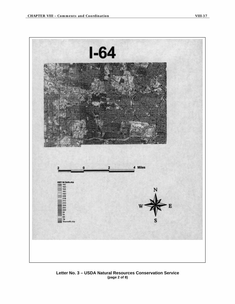
CHAPTER VIII – Comments and Coordination VIII-37
Letter No. 3 – USDA Natural Resources Conservation Service (page 2 of 8)

VIII-38 The New I-64 Final Environmental Impact Statement
Letter No. 3 – USDA Natural Resources Conservation Service (page 3 of 8)

CHAPTER VIII – Comments and Coordination VIII-39
Letter No. 3 – USDA Natural Resources Conservation Service (page 4 of 8)

VIII-40 The New I-64 Final Environmental Impact Statement
Letter No. 3 – USDA Natural Resources Conservation Service (page 5 of 8)

CHAPTER VIII – Comments and Coordination VIII-41
Letter No. 3 – USDA Natural Resources Conservation Service (page 6 of 8)

VIII-42 The New I-64 Final Environmental Impact Statement
Letter No. 3 – USDA Natural Resources Conservation Service (page 7 of 8)
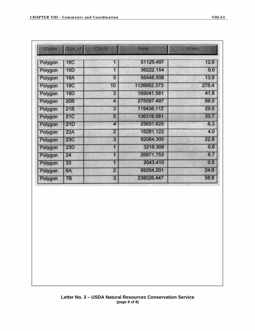
CHAPTER VIII – Comments and Coordination VIII-43
Letter No. 3 – USDA Natural Resources Conservation Service (page 8 of 8)

VIII-44 The New I-64 Final Environmental Impact Statement
Letter No. 4 – U.S. Environmental Protection Agency (page 1 of 5)
4A

CHAPTER VIII – Comments and Coordination VIII-45
Letter No. 4 – U.S. Environmental Protection Agency (page 2 of 5)
4B

VIII-46 The New I-64 Final Environmental Impact Statement
Letter No. 4 – U.S. Environmental Protection Agency (page 3 of 5)
4C 4D 4E 4F

CHAPTER VIII – Comments and Coordination VIII-47
Letter No. 4 – U.S. Environmental Protection Agency (page 4 of 5)

VIII-48 The New I-64 Final Environmental Impact Statement
Letter No. 4 – U.S. Environmental Protection Agency (page 5 of 5)

CHAPTER VIII – Comments and Coordination VIII-49
Letter No. 5 – U.S. Department of the Interior (page 1 of 5)
5A

VIII-50 The New I-64 Final Environmental Impact Statement
Letter No. 5 – U.S. Department of the Interior (page 2 of 5)
5B 5C 5D 5E

CHAPTER VIII – Comments and Coordination VIII-51
Letter No. 5 – U.S. Department of the Interior (page 3 of 5)
5F 5G 5H 5I

VIII-52 The New I-64 Final Environmental Impact Statement
Letter No. 5 – U.S. Department of the Interior (page 4 of 5)
5J

CHAPTER VIII – Comments and Coordination VIII-53
Letter No. 5 – U.S. Department of the Interior (page 5 of 5)

VIII-54 The New I-64 Final Environmental Impact Statement
Letter No. 6 – State Emergency Management Agency
6

CHAPTER VIII – Comments and Coordination VIII-55
Letter No. 7 – Missouri State Historic Preservation Office
7

VIII-56 The New I-64 Final Environmental Impact Statement
Letter No. 8 – Missouri Office of Administration, Intergovernmental Relations

CHAPTER VIII – Comments and Coordination VIII-57
Letter No. 9 – Missouri Department of Natural Resources (page 1 of 5)

VIII-58 The New I-64 Final Environmental Impact Statement
Letter No. 9 – Missouri Department of Natural Resources (page 2 of 5)
9A

CHAPTER VIII – Comments and Coordination VIII-59
Letter No. 9 – Missouri Department of Natural Resources (page 3 of 5)
9B 9C 9D 9E

VIII-60 The New I-64 Final Environmental Impact Statement
Letter No. 9 – Missouri Department of Natural Resources (page 4 of 5)
9F 9G 9H 9I 9J

CHAPTER VIII – Comments and Coordination VIII-61
Letter No. 9 – Missouri Department of Natural Resources (page 5 of 5)
9K 9L 9M

VIII-62 The New I-64 Final Environmental Impact Statement
Letter No. 10 – City of St. Louis, Division of Parks
10

CHAPTER VIII – Comments and Coordination VIII-63
Letter No. 11 – City of Ladue (page 1 of 2)
11A 11B 11C
11D 11E 11F 11G 11H

VIII-64 The New I-64 Final Environmental Impact Statement
Letter No. 11 – City of Ladue (page 2 of 2)

CHAPTER VIII – Comments and Coordination VIII-65
Letter No. 12 – City of Brentwood Resolution No. 891 (page 1 of 2)
12A 12B 12C

VIII-66 The New I-64 Final Environmental Impact Statement
Letter No. 12 – City of Brentwood Resolution No. 891 (page 2 of 2)
12D
12E 12F 12G

CHAPTER VIII – Comments and Coordination VIII-67
Letter No. 13 – Andrea C. Ferster Law Offices for City of Richmond Heights (page 1 of 8)

VIII-68 The New I-64 Final Environmental Impact Statement
Letter No. 13 – Andrea C. Ferster Law Offices for City of Richmond Heights (page 2 of 8)
13A 13B

CHAPTER VIII – Comments and Coordination VIII-69
Letter No. 13 – Andrea C. Ferster Law Offices for City of Richmond Heights (page 3 of 8)
13C 13D

VIII-70 The New I-64 Final Environmental Impact Statement
Letter No. 13 – Andrea C. Ferster Law Offices for City of Richmond Heights (page 4 of 8)
13E
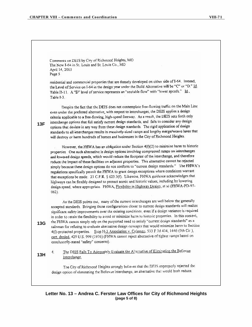
CHAPTER VIII – Comments and Coordination VIII-71
Letter No. 13 – Andrea C. Ferster Law Offices for City of Richmond Heights (page 5 of 8)
13F 13G 13H

VIII-72 The New I-64 Final Environmental Impact Statement
Letter No. 13 – Andrea C. Ferster Law Offices for City of Richmond Heights (page 6 of 8)

CHAPTER VIII – Comments and Coordination VIII-73
Letter No. 13 – Andrea C. Ferster Law Offices for City of Richmond Heights (page 7 of 8)

VIII-74 The New I-64 Final Environmental Impact Statement
Letter No. 13 – Andrea C. Ferster Law Offices for City of Richmond Heights (page 8 of 8)
13I

CHAPTER VIII – Comments and Coordination VIII-75
Letter No. 14 – City of St. Louis
14
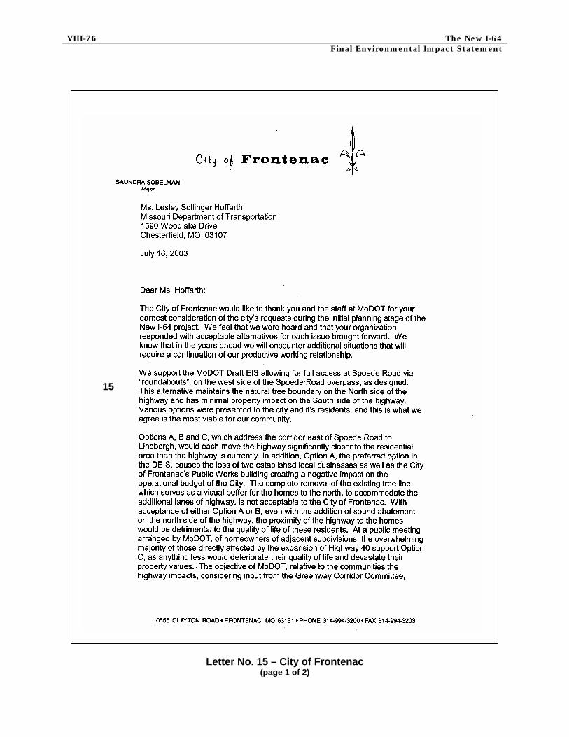
VIII-76 The New I-64 Final Environmental Impact Statement
Letter No. 15 – City of Frontenac (page 1 of 2)
15

CHAPTER VIII – Comments and Coordination VIII-77
Letter No. 15 – City of Frontenac (page 2 of 2)

VIII-78 The New I-64 Final Environmental Impact Statement
Letter No. 16 – St. Mary’s Health Center (page 1 of 2)
16

CHAPTER VIII – Comments and Coordination VIII-79
Letter No. 16 – St. Mary’s Health Center (page 2 of 2)

VIII-80 The New I-64 Final Environmental Impact Statement
Letter No. 17 – City of Richmond Heights Resolution (page 1 of 2)

CHAPTER VIII – Comments and Coordination VIII-81
Letter No. 17 – City of Richmond Heights Resolution (page 2 of 2)
17A 17B 17C
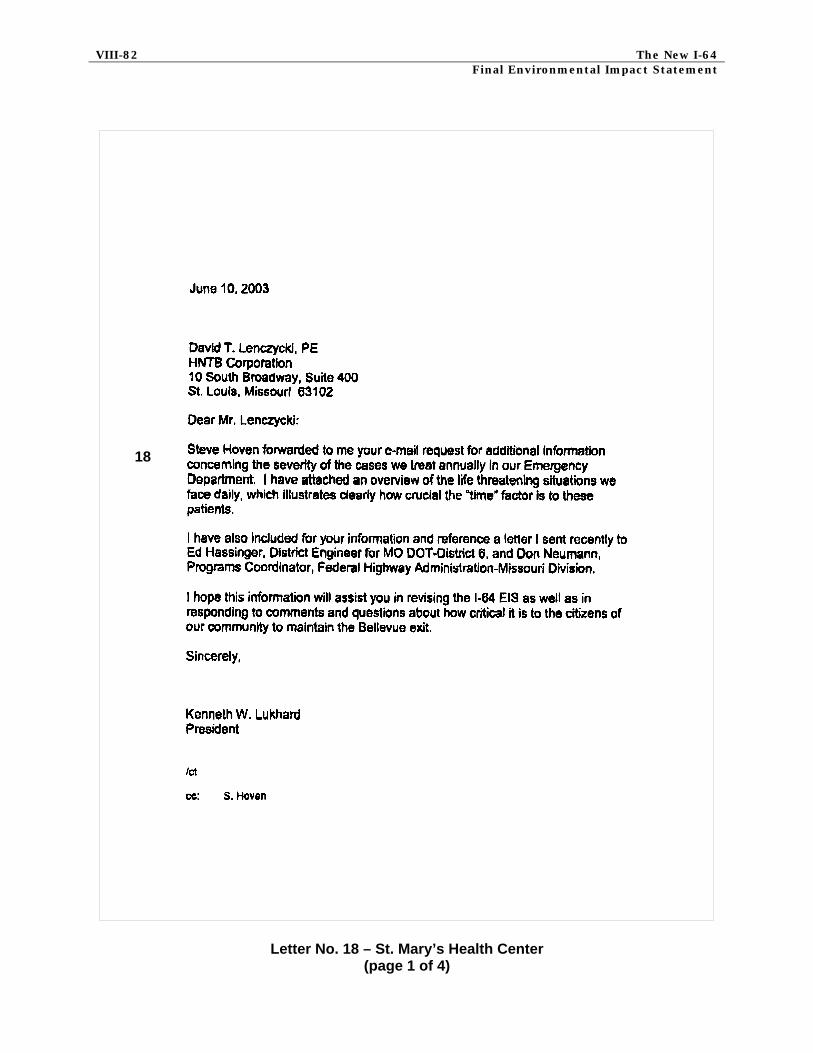
VIII-82 The New I-64 Final Environmental Impact Statement
Letter No. 18 – St. Mary’s Health Center (page 1 of 4)
18

CHAPTER VIII – Comments and Coordination VIII-83
Letter No. 18 – St. Mary’s Health Center (page 2 of 4)

VIII-84 The New I-64 Final Environmental Impact Statement
Letter No. 18 – St. Mary’s Health Center (page 3 of 4)

CHAPTER VIII – Comments and Coordination VIII-85
Letter No. 18 – St. Mary’s Health Center (page 4 of 4)

VIII-86 The New I-64 Final Environmental Impact Statement 4. RESPONSES TO AGENCY AND CITY COMMENTS
Comment codes are used in this section to reference the specific agency or city letter that the responses correspond to.
COMMENT CODE: 1 SOURCE: U.S. Department of Energy RESPONSE: Comment noted and appreciated. APPLICABLE REFERENCE: Chapter IV, S. 7. COMMENT CODE: 2A SOURCE: U.S. Department of Housing and Urban Development RESPONSE: Relocation assistance payments are designed to compensate displaced persons for costs that have been imposed on them by a MoDOT project. These payments, which are determined by the amount of time in the displaced dwelling, include the amount by which the cost of a replacement dwelling exceeds the acquisition cost of the displacement dwelling, increased interest costs and incidental costs. The Uniform Act requires that comparable, decent, safe and sanitary replacement housing within a person’s financial means be made available before that person may be displaced. MoDOT must follow the Uniform Act. APPLICABLE REFERENCE: Chapter IV, C. 2. COMMENT CODE: 2B SOURCE: U.S. Department of Housing and Urban Development RESPONSE: Public comments requesting noise barriers have been received and MoDOT is committed to fully exploring noise mitigation. To this end, MoDOT follows an established noise policy which includes conducting public meetings to determine consensus on the desire for walls at specific locations, and determining eligibility, location, type, and aesthetics of noise mitigation. These tasks will be conducted during the subsequent design process. APPLICABLE REFERENCE: Summary, E. 3. c.; Chapter IV, H. 4. COMMENT CODE: 3 SOURCE: USDA/Natural Resources Conservation Service RESPONSE: Comment noted. The area referenced is outside of the study area. APPLICABLE REFERENCE: None

CHAPTER VIII – Comments and Coordination VIII-87
COMMENT CODE: 4A SOURCE: U.S. Environmental Protection Agency RESPONSE: The Cultural Resources Report, concurrence by the SHPO, supplemental information from the City of Richmond Heights and DEIS and Section 4(f) Evaluation were transmitted to the Keeper of the NRHP by FHWA on February 9, 2004. The Keeper was given 45 days to respond to the eligibility of the individual architectural resources, the bridges and the historic districts as enumerated in the Cultural Resources Report. The FEIS was amended to include the Keeper’s decision on the eligibility of the individual architectural resources, the bridges and the historic districts as listed in the Cultural Resources Report. The Programmatic Agreement has been executed by the signatory parties and this closes the Section 106 process. The executed Programmatic Agreement is shown in Appendix K. APPLICABLE REFERENCE: Section 4(f) COMMENT CODE: 4B SOURCE: U.S. Environmental Protection Agency RESPONSE: There were minority and low-income populations identified in the Thruway and Parkway subcorridors. There are residential acquisitions within these subcorridors but the impact to these special populations is not disproportionate to the impacts on the rest of the population. In order to minimize the impact on those whose property is being acquired, relocation assistance payments are available. These payments are designed to compensate displaced persons for costs that have been imposed on them by a MoDOT project. These payments, which are determined by the amount of time in the displaced dwelling, include the amount by which the cost of a replacement dwelling exceeds the acquisition cost of the displacement dwelling, increased interest costs and incidental costs. The Uniform Act requires that comparable, decent, safe and sanitary replacement housing within a person’s financial means be made available before that person may be displaced. MoDOT must follow the Uniform Act. Other possible impacts to residents in the corridor, including minority and low-income households, include vehicle access to I-64, pedestrian access, transit access, noise and construction impacts. Changes in access to these neighborhoods would not adversely affect the residents and would ultimately improve the access to these areas. Pedestrian access in all of the subcorridors would be enhanced within the state right of way and in the parkway some pedestrian access is being relocated to make it more accessible to residents and public transportation. Pedestrian access within the project area is also being improved where necessary to comply with ADA standards. Considerations in the planning of ramp capacity have been made to accommodate vehicle and pedestrian trips to two new light rail stations. MoDOT will follow its policy on noise abatement (Chapter IV, Section H) to mitigate noise impacts and will provide for additional public input during the design phase. MoDOT will develop maintenance of traffic and construction schedules with the goal of reducing construction-related impacts to residents throughout the corridor. APPLICABLE REFERENCE: Chapter IV, B. 5. b.; Chapter IV, S.

VIII-88 The New I-64 Final Environmental Impact Statement COMMENT CODE: 4C SOURCE: U.S. Environmental Protection Agency RESPONSE: This project is included in the conformity analysis concluded by the East-West Gateway Coordinating Council. In order to meet the standards the region will follow transportation control measures outlined in the plan. The project will be required to comply with the new conformity requirements, and further conformity analysis may be required for the proposed action. APPLICABLE REFERENCE: Chapter IV, G. 2. COMMENT CODE: 4D SOURCE: U.S. Environmental Protection Agency RESPONSE: The text has been amended to reflect that the information is based on 1998 data and that although the Index of Watershed Indicators is not current, this is the most recent information available. APPLICABLE REFERENCE: Chapter III, B. 2. a. COMMENT CODE: 4E SOURCE: U.S. Environmental Protection Agency RESPONSE: A map indicating the geographic boundaries of areas that have low income households has been added to the FEIS. A map indicating the geographic boundaries of areas with minority households is shown on an exhibit that appeared in the DEIS and is included in the FEIS. APPLICABLE REFERENCE: Exhibit IV-2a and IV-2b COMMENT CODE: 4F SOURCE: U.S. Environmental Protection Agency RESPONSE: To clarify the response, an adverse impact means that those properties will be acquired. The adverse effect on the Lavinia Gardens Historic District consists of the removal of four buildings from the district, which contains nineteen contributing primary resources. The district will still retain eligibility for listing on the NRHP following the construction of this project. Continued design to minimize impacts has eliminated the adverse effect on the Clayton Park Addition (Bennett Avenue) District, which will continue to be eligible for the NRHP following the construction of this project. APPLICABLE REFERENCE: Chapter IV, O. 4.

CHAPTER VIII – Comments and Coordination VIII-89
COMMENT CODE: 5A SOURCE: U.S. Department of the Interior RESPONSE: It is the procedure for FHWA to not make a determination until the FEIS is completed as to whether there are no prudent and feasible alternatives. This makes it possible to review the comments from the public and the agencies, particularly those that oversee the 4(f) properties concerned to consider their input before a final decision is made by FHWA. APPLICABLE REFERENCE: None COMMENT CODE: 5B SOURCE: U.S. Department of the Interior RESPONSE: Comment noted. APPLICABLE REFERENCE: None COMMENT CODE: 5C SOURCE: U.S. Department of the Interior RESPONSE: Comment noted. APPLICABLE REFERENCE: None COMMENT CODE: 5D SOURCE: U.S. Department of the Interior RESPONSE: Comment noted. APPLICABLE REFERENCE: None COMMENT CODE: 5E SOURCE: U.S. Department of the Interior RESPONSE: Following comments on the DEIS, the Preferred Alternative was redesigned and no longer impacts The Heights Community Center. APPLICABLE REFERENCE: None COMMENT CODE: 5F SOURCE: U.S. Department of the Interior RESPONSE: A specific mitigation plan has been developed by MoDOT and FHWA and has been presented to the City of Richmond Heights. Richmond Heights has obtained input from

VIII-90 The New I-64 Final Environmental Impact Statement the adjacent neighborhoods, met with MoDOT a second time and has provided comments on the mitigation plan. A letter from Richmond Heights describing features that the City desired to be considered as part of the mitigation plan was provided by the city and is included in the Section 4(f) appendix. APPLICABLE REFERENCE: Section 4(f) COMMENT CODE: 5G SOURCE: U.S. Department of the Interior RESPONSE: Noise levels generally increase by one decibel as a result of moving at least one travel lane closer to a receiver. Lowering the grade of the roadway facility at this location may negate that effect. A one decibel increase would be an imperceptible change in noise level to the high levels already experienced in this area. Therefore since the upgraded roadway facility would not substantially impair the utility of the park, there would not be a constructive use impact. APPLICABLE REFERENCE: None COMMENT CODE: 5H SOURCE: U.S. Department of the Interior RESPONSE: Comment noted. APPLICABLE REFERENCE: None COMMENT CODE: 5I SOURCE: U.S. Department of the Interior RESPONSE: On February 26, 2003 the City of St. Louis sent a letter to MoDOT confirming that the Department of Parks, Recreation and Forestry has had an opportunity to review the Draft EIS and understands the impacts to Forest Park. The letter stated that the Parks Department understood and concurred that the proposed mitigation efforts as described in the 4(f) Section of the DEIS are appropriate. On June 17, 2003, the Office of the Mayor of the City of St. Louis also sent a letter supporting the proposed mitigation measures proposed in Forest Park. APPLICABLE REFERENCE: Appendix 4(f)-J COMMENT CODE: 5J SOURCE: U.S. Department of the Interior RESPONSE: Comment noted. DOI concurs there would be no 4(f) use of Highland Park and no impact to the 6(f) property either. APPLICABLE REFERENCE: None

CHAPTER VIII – Comments and Coordination VIII-91
COMMENT CODE: 6 SOURCE: State Emergency Management Agency RESPONSE: The text has been revised to reflect the changes suggested in the comment. APPLICABLE REFERENCE: Chapter IV, L. 1. b. COMMENT CODE: 7 SOURCE: Missouri State Historic Preservation Office RESPONSE: Comment noted and appreciated. Bridge K468 has not been included in the list of eligible bridges because it falls outside of the project area and is being dealt with in a separate independent project. APPLICABLE REFERENCE: None COMMENT CODE: 9A SOURCE: Missouri Department of Natural Resources RESPONSE: Comment noted. APPLICABLE REFERENCE: None COMMENT CODE: 9B SOURCE: Missouri Department of Natural Resources RESPONSE: It is anticipated that construction of the project will not result in an increase in the floodway elevations and will not otherwise require revisions to the floodplain map. The statement regarding map revision has been deleted from the text. APPLICABLE REFERENCE: Chapter IV, L. b. COMMENT CODE: 9C SOURCE: Missouri Department of Natural Resources RESPONSE: In Chapter IV, Section J. Water Quality Impacts addresses this issue. The last sentence of the third paragraph of Section J.1.b. mentions the inclusion of drainage basins. The text has been amended as follows: “Temporary and permanent runoff drainage (retention or detention) basins will also be designed and installed to lessen water quality impacts by trapping sediment and other contaminants, while reducing erosive storm surges. APPLICABLE REFERENCE: Chapter IV, J. 1. b.
VIII-92 The New I-64 Final Environmental Impact Statement COMMENT CODE: 9D SOURCE: Missouri Department of Natural Resources RESPONSE: MoDOT will consider using native vegetation in disturbed areas as appropriate. The use of native planting and seeding is discussed in Chapter IV, Section J.1.b., end of the second paragraph regarding “methods to minimize impacts”. Incorporating native vegetation is also discussed in that same section, in the 4th paragraph. APPLICABLE REFERENCE: Chapter IV, J. 1. b. COMMENT CODE: 9E SOURCE: Missouri Department of Natural Resources RESPONSE: In Chapter IV, Section J.1.b., the second paragraph has been amended as follows: “…………. .all other stream crossings would utilize culverts or culvert extensions that maintain the low-flow characteristics of the streams.” This same paragraph goes on to state that “….the project will comply with specific requirements of Section 401 Water Quality Certification and Section 404 Permits.” MoDOT will design culverts to appropriate required sizes and will be aware of the hydraulic implications resulting from adequate flows. APPLICABLE REFERENCE: Chapter IV, J. 1. b. COMMENT CODE: 9F SOURCE: Missouri Department of Natural Resources RESPONSE: In Chapter IV, Section I.4., the second paragraph discusses the incorporation of bio-engineering techniques for bank stabilization, and the use of native seeding and plantings along the buffer zones adjacent to stream banks. The remainder of Comment No. 9F is a repeat of Comments 9C, 9D, and 9E (see corresponding responses above). APPLICABLE REFERENCE: Chapter IV, I. 4. COMMENT CODE: 9G SOURCE: Missouri Department of Natural Resources RESPONSE: A list of references was provided at the end of Chapter III in the DEIS, which includes sources of geologic information. APPLICABLE REFERENCE: Chapter III, C.

CHAPTER VIII – Comments and Coordination VIII-93
COMMENT CODE: 9H SOURCE: Missouri Department of Natural Resources RESPONSE: The issue of seismic risks has been addressed through additional text in this document. APPLICABLE REFERENCE: Chapter III, B. 3. c. COMMENT CODE: 9I SOURCE: Missouri Department of Natural Resources RESPONSE: The text referred to in the comment has been revised to reflect the changes suggested. APPLICABLE REFERENCE: Chapter III, B. 3. a. COMMENT CODE: 9J SOURCE: Missouri Department of Natural Resources RESPONSE: The study area is an urban environment making further identification of karst features difficult. However, as project design continues further geo-technical information will be obtained. If karst features are identified they will be taken into account during detailed design and construction. APPLICABLE REFERENCE: None COMMENT CODE: 9K SOURCE: Missouri Department of Natural Resources RESPONSE: The text referred to in the comment has been revised to reflect the changes suggested. Also, the approximate locations of underground mine entries and shafts, and an estimated extent of mined-out areas within the study corridor are shown in Exhibit III-1B and 1C. These locations were developed from a 1987 map developed by MDNR entitled Underground Coal and Clay Mines in the city of St. Louis, Missouri. APPLICABLE REFERENCE: Chapter III, B. 3. a. and Exhibit III-1B and 1C. COMMENT CODE: 9L SOURCE: Missouri Department of Natural Resources RESPONSE: This information is presented in Chapter III, Section B.3.a. and Chapter IV, Section J.2. Further geotechnical information will be obtained during final design in order to identify geologic characteristics that can influence grading operations and structural design. APPLICABLE REFERENCE: Chapter III, B. 3. a.

VIII-94 The New I-64 Final Environmental Impact Statement COMMENT CODE: 9M SOURCE: Missouri Department of Natural Resources RESPONSE: Additional consultation with the State Historic Preservation Office (SHPO) has been completed. The building number 193 was removed from list of eligible properties and the Section 4(f) Evaluation based on the SHPO’s determination. Bridge K468 has not been included in the list of eligible bridges because it falls outside of the project area and is being dealt with in a separate independent project. APPLICABLE REFERENCE: Chapter III, B. 6. c. and Section 4(f) Evaluation, D. 1. COMMENT CODE: 10 SOURCE: City of St. Louis, Division of Parks RESPONSE: Comment noted. APPLICABLE REFERENCE: None COMMENT CODE: 11A SOURCE: City of Ladue RESPONSE: The design standard for median shoulder width follows the Policy of Geometric Design of Highways and Streets, produced by the American Association of State Highway and Transportation Officials (AASHTO) 2001. This standard is that on freeways of six or more lanes the usable paved width of the median shoulder should be 10 feet and preferably 12 feet where the design hour volume for truck traffic exceeds 250 vehicles per hour, as does this portion of I-64. MoDOT’s standard is 12 feet in the urban areas to allow for maintenance and disabled vehicles. APPLICABLE REFERENCE: None COMMENT CODE: 11B SOURCE: City of Ladue RESPONSE: MTIA identified the need for additional lane capacity on I-64 west of I-170, and this EIS is consistent with that recommendation. ITS and other transportation systems management techniques will be used throughout the entire corridor. There is a large volume of traffic moving between I-170 and the western portion of the county. Additional mainline capacity is included in the preferred alternative from Spoede to I-170 in order to accommodate higher projected volumes in this portion of the corridor. APPLICABLE REFERENCE: Chapter I, D. 2. and Chapter II, D. 1.

CHAPTER VIII – Comments and Coordination VIII-95
COMMENT CODE: 11C SOURCE: City of Ladue RESPONSE: Additional capacity on I-64 from Spoede to I-170 should contribute to improving the mobility of the local arterial street system. APPLICABLE REFERENCE: None COMMENT CODE: 11D SOURCE: City of Ladue RESPONSE: The preferred alternative includes the reconstruction of Lindbergh north of Clayton. The intersection operation of Clayton and Lindbergh does not negatively impact I-64, and the New I-64 does not negatively impact the Clayton/Lindbergh intersection, and as such improvements are not part of the proposed action. APPLICABLE REFERENCE: None COMMENT CODE: 11E SOURCE: City of Ladue RESPONSE: The microscale analysis included localized impacts for carbon monoxide. The Build Alternative would not result in any new violations of the regional air quality standards. The mesoscale analysis looked at impacts of the project for ozone. This analysis was performed by EWGCC when it was necessary to show conformity with the SIP. At that stage, the project was shown to produce ozone precursors, VOC and NOx, that were within the emissions budget for the area. Therefore the project would not increase the occurrence of violations to the National Ambient Air Quality Standards (NAAQS), increase the severity of violations to the NAAQS or lead to any new violations of the NAAQS. The mesoscale analysis may be updated by EWGCC as part of a future conformity analysis related to new standards being adapted by the EPA. As part of an existing conformity analysis, it is expected that the I-64 project would not be affected by the new conformity requirements. EWGCC and MoDOT will continue to monitor and adhere to any impacts of conformity requirements. APPLICABLE REFERENCE: Chapter IV, G. 2. and 3. COMMENT CODE: 11F SOURCE: City of Ladue RESPONSE: The vertical profile shown in the plates included in the Appendix C indicates an increase in height of between 10 and 30 feet. MoDOT will examine opportunities to refine the vertical profile of I-64 as they move into design to lessen the visual disruption of the environment. APPLICABLE REFERENCE: None

VIII-96 The New I-64 Final Environmental Impact Statement COMMENT CODE: 11G SOURCE: City of Ladue RESPONSE: MoDOT is examining lighting options that will minimize lighting impacts to adjacent properties. Text has been added to address the issue of lighting impacts. APPLICABLE REFERENCE: Chapter IV, Q. 5. COMMENT CODE: 11H SOURCE: City of Ladue RESPONSE: MoDOT’s desire is to construct the project in as large a phase is possible over the shortest period of time but this will be dependent upon the availability of funds. APPLICABLE REFERENCE: None COMMENT CODE: 12A SOURCE: City of Brentwood Resolution No. 891 RESPONSE: The preferred alternative eliminates the northbound left turn from Hanley to Eager in order to provide sufficient spacing between I-64 ramps and Eager Road. Access to retail activity along Eager Road for this movement will need to be made through use of internal circulation. The impacts to sales and sales tax revenues is unknown and cannot be explicitly measured. APPLICABLE REFERENCE: None COMMENT CODE: 12B SOURCE: City of Brentwood Resolution No. 891 RESPONSE: The noise level is shown to be at or above the 66 decibel level at this location within the I-64 corridor for the preferred alternative. MoDOT’s Standards and Noise Abatement Policy is described in Chapter IV, H. 2. APPLICABLE REFERENCE: Chapter IV, H. 2. COMMENT CODE: 12C SOURCE: City of Brentwood Resolution No. 891 RESPONSE: MoDOT will coordinate with local communities by providing construction scheduling information and will provide assistance to these communities in traffic management. More information about maintenance of traffic during construction can be found in Chapter IV, S. 7. APPLICABLE REFERENCE: Chapter IV, S. 7.

CHAPTER VIII – Comments and Coordination VIII-97
COMMENT CODE: 12D SOURCE: City of Brentwood Resolution No. 891 RESPONSE: The following paragraph has been added to the text in Chapter IV, K.1.b. Thruway Alternative 3 (Preferred): Although this alternative would have no direct impact to the floodplain or the floodway of Black Creek at the I-64/I-170/Brentwood Blvd. interchange, the downstream effect of stormwater runoff from additional pavement will be evaluated during the design phase. It is anticipated that stormwater runoff from the additional pavement in this area would not be substantial enough to contribute to flooding downstream. However, if it is determined that there would be any measurable runoff that would contribute to flooding downstream, then detention options could be considered. As discussed in “Floodplain Permits”, section L..1.b. of this chapter, before any work can be done in a regulatory floodway, a “No-rise” certificate must first be issued, requiring a hydraulic study that would show that there would be no effects on the floodway elevations. This would occur in the design phase. In Chapter III, Section B.4.d. Floodplains, there is a short paragraph discussing a report that investigated the flooding at Hanley Industrial Court. In addition to that, the following text summarizes the report in more detail: In May of 2001, the City of Brentwood commissioned an engineering study to determine if any measures could be taken in Black Creek or the Galleria detention pond to reduce the flooding that occurs at the Hanley Industrial Court, downstream (south) of the I-64/I-170/Brentwood Blvd. interchange, from a 2-year or more storm event. The study found that the detention pond is not used to detain stormwater. Instead, stormwater runoff from the Galleria development bypasses the detention pond and is discharged directly into Black Creek via a 66-inch diameter pipe. The berm around the detention area does not overtop and overflow into the detention area until a 5-year storm event occurs. The study also stated that if stormwater from the Galleria development during a 2-year storm event would be discharged into the detention pond area it would result in only a 2-inch decrease in the water level, and that this would be insignificant because turbulence (waves, whitewater) can account for a 2-inch rise in water levels. The study also looked at another option that would reduce the possibility of flooding downstream for a 2-year storm by constructing a weir in the mouth of the box culvert under I-64 and removing the berm around the detention pond. However, this would cause a rise in the 100-year base flood elevation upstream, which would violate National Flood Insurance Policy (NFIP) regulations. This study referenced another report that was done by the same engineering firm in 1996 titled “Black Creek Flood Study”, which was commissioned by the City of Brentwood to investigate the causes of flooding in Black Creek and to develop some possible solutions. Based on interviews with business owners in the Hanley Industrial Court area, it was discovered that some of the manholes in the street would blow into the air, due to overcharging, just prior to the creek overflowing its banks, and that the manhole cover blowing seemed to increase after the Galleria was constructed. In addition, it was discovered that the Galleria storm sewer was extensively reworked to accommodate the development and that an 18-inch sanitary bypass sewer may have been

VIII-98 The New I-64 Final Environmental Impact Statement oversized and could be contributing to the problem of downstream flooding. The study recommended further investigation of this matter, however, the City of Brentwood has not conducted any additional investigations to date. APPLICABLE REFERENCE: Chapter IV, K.1.b. and Chapter III, B.4.d. COMMENT CODE: 12E SOURCE: City of Brentwood Resolution No. 891 RESPONSE: Comment noted. APPLICABLE REFERENCE: None COMMENT CODE: 12F SOURCE: City of Brentwood Resolution No. 891 RESPONSE: Comment noted. APPLICABLE REFERENCE: None COMMENT CODE: 12G SOURCE: City of Brentwood Resolution No. 891 RESPONSE: Based on a review of the refined Preferred Alternative alignment there will be three total single-family residential acquisitions within the City of Brentwood. When properties are acquired, the houses will be demolished and removed. The property will be maintained by MoDOT. APPLICABLE REFERENCE: Chapter IV, C. 1. a. COMMENT CODE: 13A SOURCE: Andrea C. Ferster Law Offices for City of Richmond Heights RESPONSE: In response to concerns related to review time, the comment period was extended for an additional 45 days, ending May 30, 2003. APPLICABLE REFERENCE: None COMMENT CODE: 13B SOURCE: Andrea C. Ferster Law Offices for City of Richmond Heights RESPONSE: An alternative analysis, including avoidance and whether or not an alternative is feasible and prudent, has been performed in accordance with Section 4(f) policy and guidance. This analysis for these historic properties can be found within the Final Section 4(f) Evaluation. APPLICABLE REFERENCE: Section 4(f)

CHAPTER VIII – Comments and Coordination VIII-99
COMMENT CODE: 13C
SOURCE: Andrea C. Ferster Law Offices for City of Richmond Heights
RESPONSE: Richmond Heights requested to be a consulting party under Section 106. Consulting parties are entitled to share their views, offer ideas, and consider possible solutions regarding the section 106 review of this project. Richmond Heights’ comments regarding the eligibility of resources and the effects of the project on historically significant resources have been reviewed by MoDOT, FHWA, the SHPO and other consulting parties to look at ways to avoid, minimize or mitigate the impacts to historic properties caused by the project. The evaluation of the eligibility of resources and effects on historic properties has been completed for the FEIS. The City of Richmond Heights has been invited to become a concurring party in the PA developed for this project, and there will be ongoing consultation regarding the mitigation of adverse effect with the community. The signed agreement is included in Appendix K.
APPLICABLE REFERENCE: Section 4(f), Appendix K
COMMENT CODE: 13D
SOURCE: Andrea C. Ferster Law Offices for City of Richmond Heights
RESPONSE: The City of Richmond Heights has had the opportunity to provide information that will be considered by SHPO in evaluation of properties or districts that may be eligible for the National Register. The report submitted by the City was reviewed by the SHPO, FHWA and MoDOT, the SHPO agreed with the City that the Clayton Park Addition was eligible for the NRHP, but did not agree that the remaining areas Richmond Heights requested be considered met the eligibility requirements for the NRHP. Since the Clayton Park Addition (Bennett Street) was treated as an eligible resource in the Draft EIS no additional historic properties were identified. At the request of the City of Richmond Heights, the FHWA forwarded information on all the potential historic districts, identified by the City, to the Keeper of the National Register of Historic Places for determinations of eligibility, as a result all historic properties within the project area in the City have been identified.
APPLICABLE REFERENCE: None
COMMENT CODE: 13E
SOURCE: Andrea C. Ferster Law Offices for City of Richmond Heights
RESPONSE: The EIS considers and evaluates alternative design options for interchanges on I-64. Numerous alternative designs and interchange types, including compressed designs such as single point and compact diamonds, were considered as part of the initial screening of options at interchange locations. These options were evaluated with respect to impacts to the natural and built environment. Based on the initial evaluation, the reasonable interchange options were incorporated as part of the build alternatives evaluated in the DEIS. Following the receipt of comments on the DEIS, interchange design options were further evaluated to look at efforts to minimize property impacts such as examining flexibility of turning radius, use of retaining walls and changes in vertical profile. Since the DEIS, property impacts within the city of Richmond Heights still exist, but were reduced. Single point and compact urban diamond interchanges were evaluated at both Hanley Road and Big Bend Boulevard interchanges. Both interchange options had similar property impacts regardless of interchange type, and recommendations to the preferred alternative were carried forward that were considered to satisfy the purpose and need for the project.
APPLICABLE REFERENCE: None

VIII-100 The New I-64 Final Environmental Impact Statement COMMENT CODE: 13F SOURCE: Andrea C. Ferster Law Offices for City of Richmond Heights RESPONSE: The design standards of ramps follow the Policy of Geometric Design of Highways and Streets, produced by AASHTO 2001. Following comments on the DEIS, MoDOT re-evaluated flexibility in design in relation to turning radius and retaining wall type and location. MoDOT did not investigate lessening any standards as to require design exceptions, but did look at the range of AASHTO acceptable design criteria. MoDOT’s proposed design is within the acceptable range right now, at or near the low end of that acceptable range. At a concept level of design, slight changes in design criteria do not make a big enough difference to save properties. The purpose of this document is to fully identify the likely worst case scenario impacts to the environment given the use of acceptable design criteria. As MoDOT moves on to detail design, every effort will be made to further minimize property impacts. APPLICABLE REFERENCE: None COMMENT CODE: 13G SOURCE: Andrea C. Ferster Law Offices for City of Richmond Heights RESPONSE: The FHWA requires that geometric design standards developed by AASHTO be followed as part of a commitment to improve highway safety. The existing I-64 within the project area does not meet the current design standards. It is the desire of FHWA and MoDOT to design I-64 to meet current standards. MoDOT and FHWA do not want to build a substandard facility. APPLICABLE REFERENCE: None COMMENT CODE: 13H SOURCE: Andrea C. Ferster Law Offices for City of Richmond Heights RESPONSE: St. Mary’s Hospital has indicated the importance of the Bellevue ramps for emergency response. A study completed for the City of Richmond Heights estimated travel times for the route from I-64 eastbound to St. Mary’s Hospital using Bellevue Avenue. In response to comments a traffic analysis was done for each of the interchange options that were refined as part of the Build Alternatives. That information is now contained in the EIS as part of Chapter II, Section B. Engineering Refinements, 4. Big Bend Boulevard/Bellevue Avenue Interchange. APPLICABLE REFERENCE: Chapter II, B. 4. COMMENT CODE: 13I SOURCE: Andrea C. Ferster Law Offices for City of Richmond Heights RESPONSE: The selection of the Preferred Alternative is based on three primary considerations – (1) the effectiveness of the alternatives to accomplish the Purpose and Need for Action, (2) the comparison of the alternatives’ overall impacts and benefits, and (3) input from the public and review agencies. The impacts regarding right-of-way have been considered when considering the overall impacts and benefits. The stacked option would have 28 less full

CHAPTER VIII – Comments and Coordination VIII-101
and 6 less partial residential property acquisitions than would the “non-stacked” or “flat” option. The stacked option is estimated to cost over $60 million (with staged construction over a 16 year period, beginning in the year 2008 and assuming an annual construction cost inflation rate of three percent) more even after right-of-way costs are considered. In addition, the stacked option has visual impacts and noise impacts that are greater than does the flat option. For these reasons, the flat option was included as part of the preferred alternative. APPLICABLE REFERENCE: Summary, F. and Chapter IV COMMENT CODE: 14 SOURCE: City of St. Louis RESPONSE: Comment noted. APPLICABLE REFERENCE: None COMMENT CODE: 15 SOURCE: City of Frontenac RESPONSE: Comment noted. APPLICABLE REFERENCE: None COMMENT CODE: 16 SOURCE: St. Mary’s Health Center RESPONSE: Comment noted. APPLICABLE REFERENCE: Chapter II COMMENT CODE: 17A SOURCE: City of Richmond Heights Resolution RESPONSE: Following the receipt of comments on the DEIS, interchange design options were further evaluated to look at efforts to minimize property impacts such as examining flexibility of turning radius, use of retaining walls and changes in vertical profile. As a result of this effort, property impacts within the city of Richmond Heights still exist, but were reduced. Recommendations to the preferred alternative were carried forward that were considered to satisfy the purpose and need for the project. After the EIS is completed, the project will continue to examine ways during final design and construction to further minimize property impacts. APPLICABLE REFERENCE: Chapter II, B.4.

VIII-102 The New I-64 Final Environmental Impact Statement COMMENT CODE: 17B SOURCE: City of Richmond Heights Resolution RESPONSE: Following the receipt of comments on the DEIS, interchange design options, including the areas adjacent to the Hanley Downs and Sheridan Hills subdivisions, were further evaluated to look at efforts to minimize property impacts such as examining flexibility of turning radius, use of retaining walls and changes in vertical profile. As a result of this effort, property impacts within the city of Richmond Heights still exist, but were reduced. Recommendations to the preferred alternative were carried forward that were considered to satisfy the purpose and need for the project. After the EIS is completed, the project will continue to examine ways during final design and construction to further minimize property impacts. APPLICABLE REFERENCE: Chapter II, B.4. COMMENT CODE: 17C SOURCE: City of Richmond Heights Resolution RESPONSE: Following the receipt of comments on the DEIS, interchange design options were further evaluated to look at efforts to minimize property impacts such as examining flexibility of turning radius, use of retaining walls and changes in vertical profile. Recommendations to the preferred alternative were carried forward that were considered to satisfy the purpose and need for the project that includes providing full access at Big Bend Boulevard interchange and access at Bellevue Avenue interchange. As a result of this effort, property impacts within the city of Richmond Heights still exist, but were reduced. After the EIS is completed, the project will continue to examine ways during final design and construction to further minimize property impacts while maintaining access at both interchanges. APPLICABLE REFERENCE: Chapter II, B.4. COMMENT CODE: 18 SOURCE: St. Mary’s Health Center RESPONSE: Comment noted. APPLICABLE REFERENCE: Chapter II, B.4.