CHAPTER II – FLOODPLAIN DATA - Maine.gov 02... · CHAPTER II – FLOODPLAIN DATA 2-5 Making Map...
15
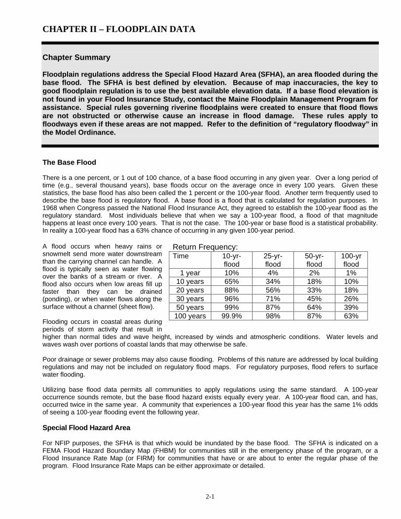
CHAPTER II – FLOODPLAIN DATA 2-1 Chapter Summary Floodplain regulations address the Special Flood Hazard Area (SFHA), an area flooded during the base flood. The SFHA is best defined by elevation. Because of map inaccuracies, the key to good floodplain regulation is to use the best available elevation data. If a base flood elevation is not found in your Flood Insurance Study, contact the Maine Floodplain Management Program for assistance. Special rules governing riverine floodplains were created to ensure that flood flows are not obstructed or otherwise cause an increase in flood damage. These rules apply to floodways even if these areas are not mapped. Refer to the definition of “regulatory floodway” in the Model Ordinance. The Base Flood There is a one percent, or 1 out of 100 chance, of a base flood occurring in any given year. Over a long period of time (e.g., several thousand years), base floods occur on the average once in every 100 years. Given these statistics, the base flood has also been called the 1 percent or the 100-year flood. Another term frequently used to describe the base flood is regulatory flood. A base flood is a flood that is calculated for regulation purposes. In 1968 when Congress passed the National Flood Insurance Act, they agreed to establish the 100-year flood as the regulatory standard. Most individuals believe that when we say a 100-year flood, a flood of that magnitude happens at least once every 100 years. That is not the case. The 100-year or base flood is a statistical probability. In reality a 100-year flood has a 63% chance of occurring in any given 100-year period. A flood occurs when heavy rains or snowmelt send more water downstream than the carrying channel can handle. A flood is typically seen as water flowing over the banks of a stream or river. A flood also occurs when low areas fill up faster than they can be drained (ponding), or when water flows along the surface without a channel (sheet flow). Flooding occurs in coastal areas during periods of storm activity that result in higher than normal tides and wave height, increased by winds and atmospheric conditions. Water levels and waves wash over portions of coastal lands that may otherwise be safe. Poor drainage or sewer problems may also cause flooding. Problems of this nature are addressed by local building regulations and may not be included on regulatory flood maps. For regulatory purposes, flood refers to surface water flooding. Utilizing base flood data permits all communities to apply regulations using the same standard. A 100-year occurrence sounds remote, but the base flood hazard exists equally every year. A 100-year flood can, and has, occurred twice in the same year. A community that experiences a 100-year flood this year has the same 1% odds of seeing a 100-year flooding event the following year. Special Flood Hazard Area For NFIP purposes, the SFHA is that which would be inundated by the base flood. The SFHA is indicated on a FEMA Flood Hazard Boundary Map (FHBM) for communities still in the emergency phase of the program, or a Flood Insurance Rate Map (or FIRM) for communities that have or are about to enter the regular phase of the program. Flood Insurance Rate Maps can be either approximate or detailed. Return Frequency: Time 10-yr- flood 25-yr- flood 50-yr- flood 100-yr flood 1 year 10% 4% 2% 1% 10 years 65% 34% 18% 10% 20 years 88% 56% 33% 18% 30 years 96% 71% 45% 26% 50 years 99% 87% 64% 39% 100 years 99.9% 98% 87% 63%
-
Upload
trinhtuyen -
Category
Documents
-
view
220 -
download
0
Transcript of CHAPTER II – FLOODPLAIN DATA - Maine.gov 02... · CHAPTER II – FLOODPLAIN DATA 2-5 Making Map...
CHAPTER II – FLOODPLAIN DATA
2-1
Chapter Summary Floodplain regulations address the Special Flood Hazard Area (SFHA), an area flooded during the base flood. The SFHA is best defined by elevation. Because of map inaccuracies, the key to good floodplain regulation is to use the best available elevation data. If a base flood elevation is not found in your Flood Insurance Study, contact the Maine Floodplain Management Program for assistance. Special rules governing riverine floodplains were created to ensure that flood flows are not obstructed or otherwise cause an increase in flood damage. These rules apply to floodways even if these areas are not mapped. Refer to the definition of “regulatory floodway” in the Model Ordinance.
The Base Flood There is a one percent, or 1 out of 100 chance, of a base flood occurring in any given year. Over a long period of time (e.g., several thousand years), base floods occur on the average once in every 100 years. Given these statistics, the base flood has also been called the 1 percent or the 100-year flood. Another term frequently used to describe the base flood is regulatory flood. A base flood is a flood that is calculated for regulation purposes. In 1968 when Congress passed the National Flood Insurance Act, they agreed to establish the 100-year flood as the regulatory standard. Most individuals believe that when we say a 100-year flood, a flood of that magnitude happens at least once every 100 years. That is not the case. The 100-year or base flood is a statistical probability. In reality a 100-year flood has a 63% chance of occurring in any given 100-year period. A flood occurs when heavy rains or snowmelt send more water downstream than the carrying channel can handle. A flood is typically seen as water flowing over the banks of a stream or river. A flood also occurs when low areas fill up faster than they can be drained (ponding), or when water flows along the surface without a channel (sheet flow). Flooding occurs in coastal areas during periods of storm activity that result in higher than normal tides and wave height, increased by winds and atmospheric conditions. Water levels and waves wash over portions of coastal lands that may otherwise be safe. Poor drainage or sewer problems may also cause flooding. Problems of this nature are addressed by local building regulations and may not be included on regulatory flood maps. For regulatory purposes, flood refers to surface water flooding. Utilizing base flood data permits all communities to apply regulations using the same standard. A 100-year occurrence sounds remote, but the base flood hazard exists equally every year. A 100-year flood can, and has, occurred twice in the same year. A community that experiences a 100-year flood this year has the same 1% odds of seeing a 100-year flooding event the following year. Special Flood Hazard Area For NFIP purposes, the SFHA is that which would be inundated by the base flood. The SFHA is indicated on a FEMA Flood Hazard Boundary Map (FHBM) for communities still in the emergency phase of the program, or a Flood Insurance Rate Map (or FIRM) for communities that have or are about to enter the regular phase of the program. Flood Insurance Rate Maps can be either approximate or detailed.
Return Frequency: Time 10-yr-
flood 25-yr-flood
50-yr-flood
100-yr flood
1 year 10% 4% 2% 1% 10 years 65% 34% 18% 10% 20 years 88% 56% 33% 18% 30 years 96% 71% 45% 26% 50 years 99% 87% 64% 39%
100 years 99.9% 98% 87% 63%
CHAPTER II – FLOODPLAIN DATA
2-2
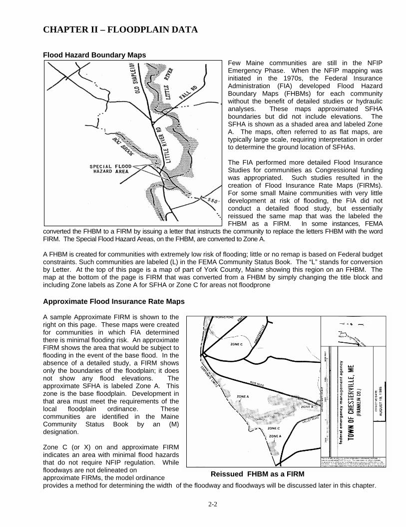
Flood Hazard Boundary Maps
Few Maine communities are still in the NFIP Emergency Phase. When the NFIP mapping was initiated in the 1970s, the Federal Insurance Administration (FIA) developed Flood Hazard Boundary Maps (FHBMs) for each community without the benefit of detailed studies or hydraulic analyses. These maps approximated SFHA boundaries but did not include elevations. The SFHA is shown as a shaded area and labeled Zone A. The maps, often referred to as flat maps, are typically large scale, requiring interpretation in order to determine the ground location of SFHAs. The FIA performed more detailed Flood Insurance Studies for communities as Congressional funding was appropriated. Such studies resulted in the creation of Flood Insurance Rate Maps (FIRMs). For some small Maine communities with very little development at risk of flooding, the FIA did not conduct a detailed flood study, but essentially reissued the same map that was the labeled the FHBM as a FIRM. In some instances, FEMA
converted the FHBM to a FIRM by issuing a letter that instructs the community to replace the letters FHBM with the word FIRM. The Special Flood Hazard Areas, on the FHBM, are converted to Zone A. A FHBM is created for communities with extremely low risk of flooding; little or no remap is based on Federal budget constraints. Such communities are labeled (L) in the FEMA Community Status Book. The “L” stands for conversion by Letter. At the top of this page is a map of part of York County, Maine showing this region on an FHBM. The map at the bottom of the page is FIRM that was converted from a FHBM by simply changing the title block and including Zone labels as Zone A for SFHA or Zone C for areas not floodprone Approximate Flood Insurance Rate Maps A sample Approximate FIRM is shown to the right on this page. These maps were created for communities in which FIA determined there is minimal flooding risk. An approximate FIRM shows the area that would be subject to flooding in the event of the base flood. In the absence of a detailed study, a FIRM shows only the boundaries of the floodplain; it does not show any flood elevations. The approximate SFHA is labeled Zone A. This zone is the base floodplain. Development in that area must meet the requirements of the local floodplain ordinance. These communities are identified in the Maine Community Status Book by an (M) designation. Zone C (or X) on and approximate FIRM indicates an area with minimal flood hazards that do not require NFIP regulation. While floodways are not delineated on approximate FIRMs, the model ordinance provides a method for determining the width of the floodway and floodways will be discussed later in this chapter.
Reissued FHBM as a FIRM

CHAPTER II – FLOODPLAIN DATA
2-3
Detailed FIRMs When a detailed study was justified (along the coast, along major rivers, and around major lakes), a detailed FIRM was produced. Within a community there may be areas for which a detailed study was conducted and areas for which only approximate flood boundaries were established. A detailed FIRM shows the boundaries of the base flood. (See portion of detailed FIRM below). Again, the SFHA is labeled as one of several types of A Zones or, in the case of coastal communities, V Zones. A FIRM may show the following zones or designations:
3. Zone AO - An area of 100 year shallow flooding where depths are between one and three feet. Average
depths of inundation may be shown, but no elevations are indicated. Regulations apply. 4. Zone AH - An area of 100 year shallow flooding with a constant water-surface elevation (usually areas of
ponding) where average depths are between one and three feet. The BFEs derived from the detailed hydraulic analyses are shown at selected intervals within this zone. Regulations apply to these areas.
5. Zone B and (lightly shaded) Zone X – Generally the 500 year flood zone. It may also indicate certain areas
subject to 100 year flooding with average depths less than one foot or areas where the contributing drainage area is less than one square mile. Although we do not regulate in Zone B or Zone X under the NFIP, these mapped areas are reviewed by other federal agencies when siting critical facilities.
6. Zone C - An area of minimal flooding. The NFIP does not require regulation of development in Zone C. 7. Zone D - Areas where the magnitude of flooding has not been determined. Regulations do not apply to
construction in these zones. There are currently no known Zone Ds in the State of Maine. 8. Zone V - Coastal areas subject to flooding with the additional hazards associated with storm waves. Due to
lack of detailed study, no flood elevations or depths are shown. Regulations and additional construction specifications apply. There are currently no known unnumbered V Zones in the State of Maine.
9. Zones V1 through V30 and Zone VE - Numbered V Zones are areas along the coast subject to flooding with
the additional hazards associated with storm waves. Flood elevations or depths are shown. The "V" denotes
1. Zone A – Areas which have been determined by approximate methods to be Special Flood Hazard Areas. They show no elevations and are known as “unnumbered A zones.” Regulations for development apply to these areas.
2. Zones A1 through A30 and
Zone AE - Zones where the elevation of the base flood has been calculated and is shown on the map, sometimes as a wavy line that crosses the floodplain. On newer maps or revisions after 1985, Zone AE is used rather than numbered A Zones. Regulations apply in these zones.
Portion of Detailed Flood Insurance Rate Map (FIRM)

CHAPTER II – FLOODPLAIN DATA
2-4
velocity due to storm surge. On newer maps or revisions, Zone VE may be used rather than numbered V Zones. Regulations and additional construction specifications apply.
10. Zone X - This is the same Zone as is referred to, in older maps, as Zone B or C. It denotes areas of lesser
flood hazard. Regulations for construction do not apply to Zone X. 11. Coastal Barrier Resources System (CBRS) - Coastal barriers, and other protected areas identified by the
Department of the Interior (DOI). A coastal barrier is a naturally occurring island, sandbar, or other strip of land, including coastal mainland, that protects the coast from severe wave wash. The Coastal Barrier Resources Act (1982) and the Coastal Barrier Improvement Act (1990) are federal laws that were enacted and implemented as part of a DOI initiative to minimize loss of human life by discouraging development in high risk areas, reduce wasteful expenditures of federal resources, and preserve the ecological integrity of CBRS and Otherwise Protected Areas (OPAs). The laws provide this protection by prohibiting all federal expenditures or financial assistance, including flood insurance, for residential and commercial development in these areas. There are, however, some existing buildings which may be eligible for flood insurance, depending on the date they were constructed or substantially improved.
The two images below include the FIRM portion of Main Street in downtown Farmington, and a photo of the same area when it was flooded by overflow from the Sandy River in January 2006. The arrow indicates the approximate location from which the photograph was taken. The FIRM indicates that this location is floodprone since it is located in or near identified X and AE zones. Since the Town of Farmington participates in the NFIP, business and residential property owners are able to purchase flood insurance.

CHAPTER II – FLOODPLAIN DATA
2-5
Making Map Determinations The Flood Insurance Rate Map (FIRM) is used to determine if proposed development, or any part of it, is located within the Special Flood Hazard Area (SFHA). Development that falls within the SFHA is subject to the provisions of the local floodplain management ordinance. In order to make a determination, use the FIRM or FHBM index to locate the map panel for the development site. An asterisk on the panel number indicates that no flood hazard has been identified, or the entire area is situated in one flood zone and the panel was not printed. Be sure the map panel is the most recent one printed by comparing the panel suffix letter with the suffix letter shown on the current map index. Panels for some communities show different effective dates because revisions did not affect the whole community. The Community Status Book shows the most current effective map date. It is most often helpful in doing flood hazard determinations to use a tax assessor’s map indicating property boundaries. First, obtain the distance on the ground between the site and one or more identifiable points, i.e., the centerline of a road or street, a bridge, or some other cultural feature on the map. Using the map scale and the measured ground distance from these points, plot the site on the map. The degree of difficulty in locating the project site will largely depend on familiarity with the properties in the community and with the scale of the flood maps. Determinations are much more challenging when a large scale map is being used to identify property in a rural area. If the site is within the mapped flood boundary, it is subject to the provisions of the local floodplain ordinance. If the site is clearly outside the flood boundary, no floodplain regulations apply unless the site adjoins the SFHA and surveyed ground elevations at the project site are below BFE. In this instance, the site would be considered floodprone. Additional information and/or studies may be needed if it cannot be determined whether or not the site is located in a floodplain. In this instance, ground elevation, lowest adjacent grade elevation, and lowest floor elevations of any structures will be necessary for the site, therefore the applicant will have to hire a Professional Land Surveyor. A field visit and measurements on the ground may also be required. In a riverine environment, the actual site elevations should be compared to the base flood elevation, which is read from Flood Insurance Study profiles, if available. If the site is near the floodway boundary, the same process is used to determine if any portion of the site is in the floodway. In this instance, measuring identifiable land features located on both the ground and the map will be required. Scale these distances on the map to determine site location relative to the floodway boundary. Because the floodway boundary is not based on a flood elevation, both field and map measurements are needed to assess whether the site is located in a floodway. If the site is at a surveyed cross section, floodway width data from the FIS floodway data table may be used to supplement field and map measurements. Note that the width listed in the table is the distance from the floodway line on one side of the stream to the floodway line on the other side of the stream. This is important if the stream channel is the community boundary, so only about half of the floodway is shown on the community’s FIRM. If the width measured on the map at that site is not comparable to that shown in the table, the table data are to be used. If there is a significant difference, contact the FEMA regional office for an interpretation. The proportional width of the floodway from the center of the stream can be used to determine the floodway boundary on the ground. In Zones A1-30, AE, and A riverine areas for which no regulatory floodway is designated, the regulatory floodway is determined to be the channel of the river or other water course and the adjacent land areas to a distance of one-half the width of the floodplain as measured from the normal high water mark to the upland limit of the floodplain. If any portion of the building site, proposed grading, filling, bridge or other development is determined to be within the floodway, then the floodway provisions of the ordinance also apply. If the proposed development lies in more than one zone, then the standards for the most restrictive zone will also apply to the development. For example, if any portion of the proposed construction is located in an AE Zone and a VE Zone, then the entire building must meet the VE Zone requirements.
CHAPTER II – FLOODPLAIN DATA
2-6
Base Flood Elevations A base flood is that flood having a one percent chance of being equaled or exceeded in any given year. It is commonly called the 100-year flood. Therefore, a base flood elevation (BFE) would be defined as the elevation to which a body of water could be expected to rise during a 100-year flooding event. FHBMs and FIRMs show the boundaries of the SFHA. These boundaries are only as accurate as the base map used to develop the FIRM (e.g.: a topographic map and, in Maine, a USGS quadrangle map). A more detailed explanation would be, if the flood elevation is 258 feet above sea level and the base map used to develop the FIRM shows a 20-foot contour interval, the map maker used intuitive judgment to locate the floodplain boundary between the 240 and 260 foot contour lines. The actual surveyed elevation of the ground prevails for permitting. If the FIRM appears to be inaccurate, the applicant may wish to apply for a Letter of Map Amendment (LOMA). (See related discussion in Section H.) It is critical to secure base elevations, which can be found in a FEMA FIRM or a Flood Insurance Study. Both are discussed below. Detailed FIRM and Flood Insurance Studies (FIS)
If you have a detailed FIRM with numbered A1-30, or AE Zones and/or V1-30 or VE Zones, the base flood elevation is on the map. Flood elevations on the FIRM are rounded to the nearest foot. The standard practice of displaying the base flood elevation on the FIRM is as follows: if the base flood elevation is between 0.1 and 0.4, the elevation is rounded down. If the elevation is between 0.5 and 0.9, the figure is rounded up. For insurance rating, the rounding is acceptable. For floodplain management purposes and permitting, it is important to use the best or most exact number, even for areas shown between the mapped elevations areas. The FIS typically contains a flood profile for riverine floodplains. A flood profile is a graphic display of the elevation of a particular flood for the entire reach or the part of the stream that has been studied. Communities with a detailed FIRM have flood profiles in the last pages of the FIS text. This chapter also
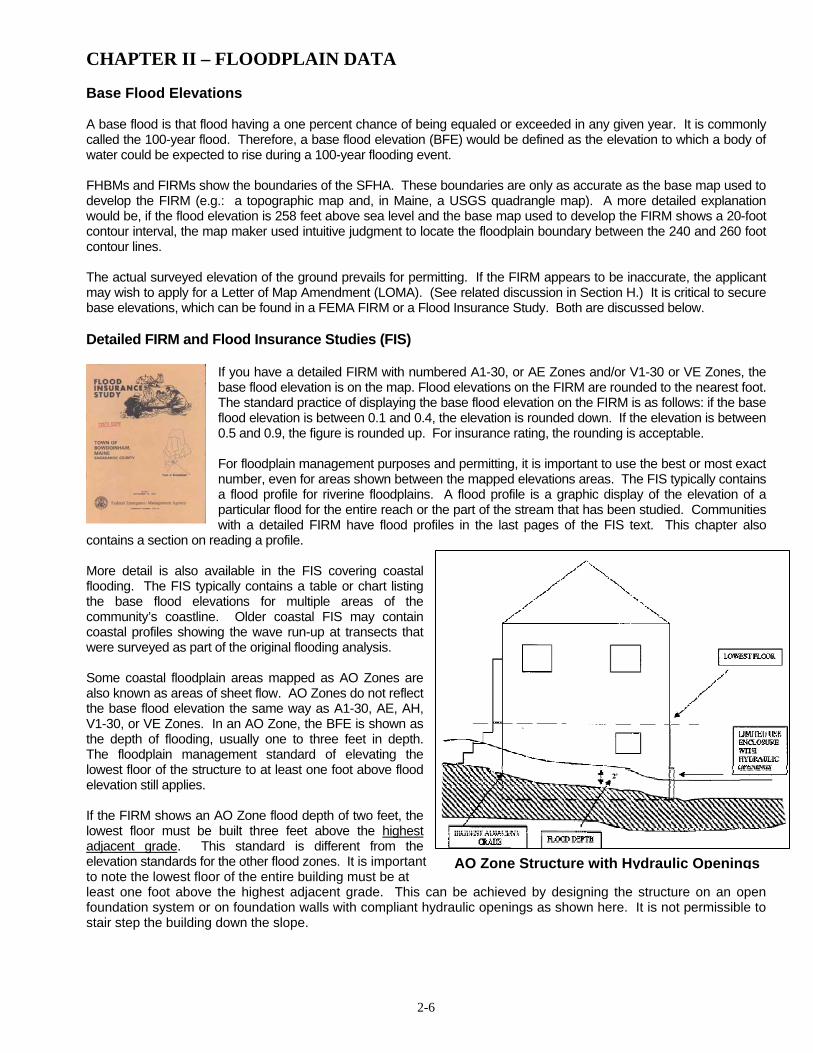
contains a section on reading a profile. More detail is also available in the FIS covering coastal flooding. The FIS typically contains a table or chart listing the base flood elevations for multiple areas of the community’s coastline. Older coastal FIS may contain coastal profiles showing the wave run-up at transects that were surveyed as part of the original flooding analysis. Some coastal floodplain areas mapped as AO Zones are also known as areas of sheet flow. AO Zones do not reflect the base flood elevation the same way as A1-30, AE, AH, V1-30, or VE Zones. In an AO Zone, the BFE is shown as the depth of flooding, usually one to three feet in depth. The floodplain management standard of elevating the lowest floor of the structure to at least one foot above flood elevation still applies. If the FIRM shows an AO Zone flood depth of two feet, the lowest floor must be built three feet above the highest adjacent grade. This standard is different from the elevation standards for the other flood zones. It is important to note the lowest floor of the entire building must be at least one foot above the highest adjacent grade. This can be achieved by designing the structure on an open foundation system or on foundation walls with compliant hydraulic openings as shown here. It is not permissible to stair step the building down the slope.
AO Zone Structure with Hydraulic Openings

CHAPTER II – FLOODPLAIN DATA
2-7
Best Available Data In approximate SFHAs (unnumbered A Zones), a community must look elsewhere for base flood elevation data. Often some other floodplain data exists. Unnumbered A Zones The following is a list of methods acceptable for determining the elevations in unnumbered A Zones. 1. Don’t reinvent the wheel!
Check the Maine Floodplain Management Program’s website for the Best Available Data (BAD). The URL is http://www.maine.gov/spo/flood/bad/. The communities are listed alphabetically and you may have to scroll down to find the alpha link. You may click on the appropriate letter that begins the name of the community you need. If we have a BFE determined for the waterbody that you need we will post it here.
2. If a waterbody forms a boundary between two
communities, the community on the other side of the river, lake or pond may have a detailed study. The base flood data for one side is valid for both sides. As we find these, they are being posted in the BAD listing on our website.
3. Hire a Professional Engineer to run the appropriate
flood model and establish the BFE in the most scientific and defensible way. The most common riverine model is HEC/RAS developed by the US Army Corps of Engineers. It is the model used in most of Maine’s Flood Insurance Studies done by FEMA for our communities along rivers. Other models are appropriate for lakes, ponds and wetlands and a different model is appropriate for ocean exposure.
4. Check with the state and federal agencies such as
US Army Corps of Engineers, USDA/Soil Conservation Service, or USGS and ask if they have knowledge of any base flood elevation reports or other unpublished reports or data that may be of assistance for the stream in question.
5. If the property is along a stream that is near any
state highway structures such as bridges or culverts, the Maine Department of Transportation may have done a study to properly size the structure. Call the
CHAPTER II – FLOODPLAIN DATA
2-8
bridge design section of DOT. Their contact information can be found on the contacts list in the beginning pages of this handbook.
6. If there is a dam on the waterbody there is a good possibility that the dam owner has had to do a study to get
relicensed. 7. Maine law requires developers of new subdivisions to provide base flood data if the subdivision is in a mapped
floodplain. Check with the town to see if there have been any new subdivisions near the site in question. The recorded plan should have the BFE and floodplain boundary on it.
8. The Best Fit approach: Compare the shaded area of the Flood Insurance Rate Map (FIRM) with the contours
on a USGS Quad map and determine which two contours the boundary of the shaded area falls between and interpolate which contour best approximates the boundary of the shaded area and use that contour and the elevation as the regulatory flood elevation. This is best done by someone familiar with contour mapping and that is familiar with “the lay of the land” in question. See the example on page 2-6.
9. Another method is the use of historical records or the flood of record. Once you know the date of the flood of
record you may be able to establish that flood’s return frequency by looking at the river basin report on the Maine Floodplain Management Website http://www.maine.gov/spo/flood/ to see if a return frequency has been established for the event. You will first need to establish which major river basin your area in located or you may contact the USGS (207-622-8201) or National Weather Service (NWS) at 207-688-3216 and ask if they have the return frequency for that specific event. If the event is less than a 100-year flooding event, the elevation information is not appropriate for determining the needed BFE.
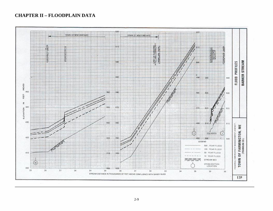
DOCUMENTATION: Whatever method you choose to use in determining the flood elevation for an unnumbered A Zone, always document on the permit application where the determination came from. It is also advisable to write the source on the FIRM or Flood Hazard Boundary Map (FHBM) that you use in the administration of the ordinance. Consistency is extremely important when working with unnumbered A Zones. If you have any questions regarding the Flood Profile, contact the staff of the Maine Floodplain Management Program. (Contact names and phone numbers are in the front of the handbook.) Code officials should at least be familiar with the procedure for checking elevations in the field. These procedures are presented in Appendix C. Along many river basins in Maine, the USDA/Natural Resources Conservation Service or the USGS have conducted flood studies. Regional Councils may also have copies of previous flood studies on file. Reading a Flood Profile The Flood Profile of Barker Stream in Farmington, Maine, is used to illustrate the discussion below, which covers how to address flood profile data. This chart is shown on the next page.
1. Check the scales used. On the example following, each bold line on the horizontal axis represents 100 feet along the stream. On the vertical axis, each line represents one half foot elevation above sea level.
2. Locate the point of concern on the horizontal axis. This is usually done by knowing its distance upstream or
downstream from a point shown on the profile. Example: the point of concern is about 750 feet downstream from corporate limit between Farmington and New Vineyard. (See page 2-9 along with the Flood Boundary and Floodway Map on page 2-10. The cross sections on the profile are located at the place indicated by the lines crossing the floodway tagged with the hexagons with corresponding letters – e.g., cross section H.)
3. Locate the point of concern on the line that represents the flood in which you are interested. Our flood on
concern is the base flood or the 100-year flood line on the profile which is the second diagonal line down from the top of the profile sheet on 2-9.
Read the vertical axis. By reading the profile sheet at Cross Section H we can see that the elevation of the 100-year flood is 423 feet plus part of another small box on the grid. We need to interpolate and reasonable interpretation would be 423.2 feet vertical elevation or more precisely 423.2 feet NGVD which is the vertical datum used in the Farmington FIS. The 10-year flood elevation is 419.9 feet NGVD.
CHAPTER II – FLOODPLAIN DATA
2-9

CHAPTER II – FLOODPLAIN DATA
2 -10
Riverine SFHAs and Floodways A riverine SFHA is any SFHA subject to overbank flooding from a river, stream, ditch, or other identified channel. It does not include areas subject to flooding from lakes, ponding areas, Zone AO, or coastal floodplains. Not all areas of riverine SFHA’s are alike. The channel and adjacent areas (known as the floodway) convey most of the water during a flood. The water outside the floodway is called the flood fringe. Water moves so slowly in the flood fringe that it is often just stored. An obstruction in the floodway will create a much greater problem than one at the edge (flood fringe), where water may not be moving. A regulatory floodway is defined in Article XIV of the Maine coastal model ordinances and in Article XIII in the b, c, and d non-coastal model ordinances as:
a. the channel of a river or other water course and the
adjacent land areas that must be reserved in order to discharge the base flood without cumulatively increasing the water surface elevation more than one foot, and
b. when not designated on the community’s FIRM or
FBFM, the channel of a river or other water course and the adjacent land areas to a distance of one-half the width of the floodplain, as measured from the normal high water mark to the upland limit of the floodplain.
Development standards are much more restrictive in floodways because there is greater chance of harm to life or property. If floodway data is available, it must be used to discourage development within the floodway. Development that would result in any increase in flood levels during the occurrence of the base flood discharge is not allowed. If no floodway data is available, then communities must treat the portion of the floodplain that is equal to one half the width of the floodplain as Floodway. See the definition discussed earlier in this section. If an applicant wishes to have a Professional Engineer calculate the floodway width needed to discharge the base flood as provided in the FEMA mapping standards they always have that option. To help local officials know the location of a floodway, FEMA has conducted floodway studies in some communities. In studies done after 1985, the floodway, if designated, is shown on the FIRM. In studies done before 1985, a Flood Boundary and Floodway Map (FBFM) is provided separate from the FIRM. A portion of a FBFM is shown here (above right). It is similar to a FIRM, but with some differences: 1. On the FBFM, the floodway is the white area near the river channel bordered by two dashed lines between the gray
colored "flood fringe" areas. On maps produced after 1985 the floodway is identified as a cross-hatched area in gray and is shown on the FIRM itself.
2. Cutting across the floodplain are a series of lines, tagged with letters in hexagonal boxes. The letters correspond to
the letters on the flood profile in the Flood Insurance Study. In addition, more information is available about these cross section locations on the Floodway Data Table (also in the FIS). A cross section is usually done at each point where the characteristics of the river change.
The Floodway Data Table on the following page provides:
a) the floodway width, b) the cross section area, c) the average floodway velocity of the base flood, and d) the base flood elevation.

CHAPTER II – FLOODPLAIN DATA
2 -11
3. Perhaps the most important difference between the FIRM and the FBFM is the inclusion of the floodway on the FBFM.
The floodplain delineation on the FIRM shows the area covered by the base flood, determined by the base flood elevation. The FBFM has delineations for both the floodplain as shown on the FIRM and the floodway. The delineation of the floodway is based on an analysis of flood flows and is not directly related to ground elevations. Floodways are often developed by use of computer programs. The only way to tell if a property is in or out of the floodway is to scale the proposal on the map using a known reference mark, such as an intersection. If you are not sure, contact the staff at the Maine Floodplain Management Program or your regional council for help.
Reading a Floodway Map Unlike floodplain boundaries, floodway boundaries are not located by elevation. Floodway dimensions are computed at the cross sections. Engineering judgment is used to draw the boundaries on the map between cross sections. The dimensions at the cross sections are available in the flood insurance study, but elsewhere map scaling is the only method that can be used. To locate a site on the map: Obtain the distance on the ground between the site and one or more identifiable points (centerline of a street, a bridge, the river channel, a reference mark, etc.). Locate these points on the floodway map. Convert the distances to the map scale and plot the site on the map. To locate a floodway boundary on the ground: Measure the map distance from one or more identifiable points. Convert these distances to the map scale. Scaling is, unfortunately, subject to the inaccuracies of the base map used. Keep in mind that the floodway represents that portion of the SFHA required to store and convey the base flood.

CHAPTER II – FLOODPLAIN DATA
2 -12
Where a floodway has not been identified by an engineering study, use the method found in the definition of "regulatory floodway" found in the Model Ordinance. The Model Ordinance provides for a regulatory floodway, one half the width of the SFHA, adjacent to the river or stream. F. Coastal High Hazard Areas Along coastal areas of the state, SFHAs are designated "Coastal High Hazard Areas," and are shown on FIRMs as "V Zones". (See map of coastal Washington County, Maine at right.) A Coastal High Hazard Area is one which will be inundated by the 100-year flood and that has an additional hazard due to wave action velocity. Many of the detailed studies done by FEMA for coastal communities have included engineering calculations to determine wave height and to account for wave run-up along beaches. V Zones are characterized by wave heights of three feet or greater. If the wave height is less than three feet, the area is mapped as an A1-30 or AE Zone. A portion of a coastal FIRM, showing wave run-up heights, is shown below, along with a typical profile of relative water levels in a V Zone. Stricter regulations apply to construction and substantial improvements within a coastal high hazard area than within other SFHAs. If located within a coastal high hazard area, buildings must be able to withstand the tremendous force of waves and winds, as well as the other effects of flooding. Structures in a V1-30 or VE Zone must meet the standards provided in the Coastal Construction Manual/FEMA 55/June 2000. The CCM is adopted by reference in Maine coastal floodplain management ordinances. G. Base Flood Studies In order to accurately predict where the base flood would go, a statistical and engineering study is required for a particular site. Greatly simplified, here are the steps involved in a riverine flood study: 1. The greatest amount of water that would flow
during a base flood is calculated. This is called the peak flood discharge and is described as the amount of water passing a point when the 100-year flood is cresting. The discharge is defined in terms of so many cubic feet per second (or "Q") flowing past the point of concern.
The discharge at this point of concern is 1,800 cubic feet per second.
The discharge is calculated by studying rainfall predictions and the drainage area (slope, ground surface, and other factors that affect runoff). On larger rivers, it is computed from stream gage records. 2. The stream channel and adjacent ground area (floodplain) is
measured and a cross-section is developed usually by surveying in channel, the sides of the stream or river, and some distance beyond the banks. This requires a certain amount of professional judgment.

CHAPTER II – FLOODPLAIN DATA
2 -13
The cross-section is a diagram that shows how much area is available to carry the peak discharge. Typically, a computer program is used to feed the discharge through the cross-section. "Roughness" factors are included to account for the landscape's effect that will slow down the flood height (or depth or elevation). A sandy bottom stream will have a different roughness coefficient than one with large boulders or one with a smooth ledge bottom.
3. For a length of stream, the process is repeated each time the
stream or river changes characteristics. A graph is prepared with a straight line connecting the flood elevations at each point. The graph represents a side view or profile of the base flood.
Flood elevations for sites between the studied cross-sections are obtained by reading the profile. Profiles are discussed in more detail later in this chapter.
4. The boundary of the floodplain is mapped. Flood elevations are
plotted on a topographic map or some other map that references ground elevations. Lines are drawn connecting these plotted points considering the actual ground elevations.
A FEMA study of base floods is called a Flood Insurance Study (FIS). When the study is completed, FEMA provides a community with a copy of the study results. These include a text, or a booklet that describes the community, its flood problems, and the engineering methods used to determine the floodplain boundary and elevations; flood profile; and a Flood Insurance Rate Map (FIRM). It may also include the Flood Boundary and Floodway Map. Mapping Floodways A floodway study in Maine is based on the following legal concepts: Property owners should be allowed to develop their land provided development does not obstruct flood flows and cause damage to others. The BFE may be increased but not if significant damages would result. Properties on both sides of a stream must be treated equitably. The degree of obstruction permitted for one must also be permitted for the other. This is called the "equal degree of encroachment rule". The floodway study is usually done with a computer. At each cross section, hypothetical obstructions are placed at the two edges. The computer assumes the base flood is flowing through the cross section. The obstructions are moved toward the center of the cross section (an equal amount of carrying capacity is taken from both sides) and the computer watches what happens to the flood height. The movement of the obstruction is stopped when the flood level reaches a predetermined increase related to increasing damages (e.g., 1 foot).

CHAPTER II – FLOODPLAIN DATA
2 -14
Two lines then mark where the obstruction was stopped. These lines divide the floodplain into three areas: The center area of faster moving water is called the floodway; the two areas of shallow, slow moving, or still water at the edges are called the flood fringe. Revising Regulatory Floodplain Data From time to time, communities or individuals may find it necessary for floodplain data to be revised. There are two methods FEMA uses to revise Flood Insurance Rate Maps. One way is to actually revise the map itself - republish the map with the revisions. The second way is to issue a letter that describes the map change. FEMA uses the second method when the revision can be adequately described in writing, saving the taxpayers the expense of republication. There are five basic reasons a map may need to be changed: 1. Revisions to correct an error: If a map shows streets or municipal boundaries in the wrong location, or if
municipal boundaries change, the community should request a map revision and send FEMA a new community map noting the corrections. The state coordinating office should also be notified.
2. Revisions based on better ground elevation data: If a detailed contour map shows errors in the floodplain
boundaries, a copy of the more detailed map should be submitted. If the base flood elevation is known (or has been more accurately computed since the map was made), it should be submitted with the revision. Where the best available maps do not clearly show a property higher than the base flood elevation, a certificate of elevation is needed (see Elevation Certificate in Appendix D). The certificate must be sealed by a Professional Land Surveyor or registered professional engineer and must show the elevation of the lowest grade adjacent to the structure and the lowest floor (including basement) of the structure in relationship to the base flood elevation.
3. Revisions based on filling in the floodplain: If there has been a substantial amount of new fill material placed in
or near the floodplain to raise building sites to elevate a new structure, a certified "as built" topographic map should be submitted to FEMA after the building has been completed. It should be noted that buildings with basements below the base flood elevation will not have revisions granted. No structure should have been built

CHAPTER II – FLOODPLAIN DATA
2 -15
in a mapped floodplain if the lowest floor is going to be below the BFE. It is always advisable to seek a conditional LOMR based on fill prior to the development.
4. Revisions based on better flood data: A FIRM is prepared as part of a Flood Insurance Study and reflects the
best data available on the base flood. Parties challenging a FIRM can do so only if the challenge is based on better or more accurate study techniques. The Floodplain Management Coordinator will help communities determine if the challenger's data is better or more accurate.
5. Revision based on new projects affecting the watercourse: A map may be revised to reflect new flood protection
measures built since the map was prepared or if a dam has been removed. In rare cases where a steam, river or other water body had been relocated or altered in a way that would change the flood elevations or boundaries a LOMR must be obtained. The NFIP Regulations at 44 CFR Part 65 put the onus on the community for ensuring that the community’s flood maps are current and correct. Plans for large projects usually include after-project flood maps that can readily be used to revise a map. However, in most cases a map cannot be changed until the project is actually constructed and/or operating. Furthermore, many small projects, such as one or two retention reservoirs or channel improvements often do not lower the base flood enough to warrant a change in BFE but the community must be certain that the flood boundaries are still correct.
Requesting a Map Revision or Map Amendment Map change requests are often submitted because a project does not appear to be at risk in a 100-year event. There are a two ways submit a request. The most frequent procedure is a Letter of Map Amendment (LOMA). LOMAs are intended to provide a method of recognizing structures or parcels that were inadvertently included in a floodplain and, because better contour data is available, to prove the project is clearly not subject to base flood damage. The LOMA process is generally used for a single residential lot or structure. Either the property owner or the community may apply for a LOMA. The other procedure is called a Letter of Map Revision (LOMR). LOMRs are intended to recognize changes that have occurred since the FIRM was published. Some examples of these changes are typically flood control projects that were constructed after the study was done, new hydraulic or hydrologic data, or better topographic representations. If a property owner believes conditions have changed that warrant an exclusion of his/her property, they must work through community officials.
(Augusta, ME) This riverside gazebo is moveable and can be towed out of the floodplain. Photo from the Maine Floodplain Management Program.
FLOOD FACTS: • There is a 1% chance of a
base flood occurring in any given year, or a 63% chance of occurrence in a 100 year-year period.
• During a 30-year mortgage
period, there is 26% chance that a SFHA property will be flooded.
• There is only a 4% chance
that a fire would affect the property during the same 30-year period.
• The odds of flooding are
comparatively high.