FLOODPLAIN MANAGEMENT IN ARKANSAS · FLOODPLAIN MANAGEMENT IN ARKANSAS 2005 ... Click the round...
58
FLOODPLAIN MANAGEMENT IN ARKANSAS 2005 Arkansas Natural Resources Commission* Floodplain Management Program http://www.anrc.arkansas.gov *formerly Arkansas Soil & Water Conservation Commission
Transcript of FLOODPLAIN MANAGEMENT IN ARKANSAS · FLOODPLAIN MANAGEMENT IN ARKANSAS 2005 ... Click the round...

FLOODPLAIN MANAGEMENT IN ARKANSAS2005
Arkansas Natural Resources Commission* Floodplain Management Program
http://www.anrc.arkansas.gov
*formerly Arkansas Soil & Water Conservation Commission

ARKANSAS QUICK GUIDE
1............ About This Guide2............ Introduction3............ Arkansas Disasters4............ Flood Insurance: Property Owner’s Best Protection5............ Turn Around Don't Drown™6............ Why Do We Regulate the Floodplain?7............ State Accreditation of Local Floodplain Administrators8............ Community Responsibilities9............ Looking for Floodplain Information?10.......... FIRMette: Flood Maps Online11.......... Understanding the Riverine Floodplain12.......... Understanding the Floodway13.......... New Format Flood Insurance Rate Map 14.......... Old Format Flood Insurance Rate Map 15.......... Old Format Flood Boundary and Floodway Map 16.......... Use the Riverine Flood Profile to Determine BFEs17.......... Digital Flood Maps 18.......... Approximate Flood Zones and Unnumbered A Zones19.......... Flood Map Revisions Issued by FEMA20.......... Activities Requiring Permits21.......... Safe Uses of the Floodplain22.......... Is Your Building Site Higher than the BFE?23.......... What is Meant by Pre-FIRM and Post-FIRM?24.......... Nature Doesn’t Read Maps25.......... Think Carefully Before You Seek A Variance26.......... Some Key Permit Review Steps27.......... Carefully Complete the Permit Application28.......... Freeboard: Go the Extra Foot!
29.......... What is the Elevation Certificate and How is it Used?30.......... Completing the Elevation Certificate31.......... Paperwork is Important – for You and Your Community32.......... Floodplain Fill Can Make Things Worse33.......... Required Floodway “No Impact” Certification34.......... How to Elevate Your Floodplain Building35.......... Compaction of Floodplain Fill36.......... Manufactured Homes Require Special Attention37.......... Enclosures Below the BFE 38.......... Crawlspace Details39.......... Basements Are Unsafe40.......... Utility Service Outside Buildings41.......... Utility Service Inside Enclosures42.......... Accessory (Appurtenant) Structures43.......... Recreational Vehicles44.......... Planning to Improve Your Floodplain Building?45.......... Non-Substantial Improvements46.......... Substantial Improvement: Renovation Only47.......... Substantial Improvement: Lateral Addition Only48.......... Substantial Improvement: Addition Plus Other Work49.......... What About After Damages?50.......... Paying for Post-Flood Compliance51.......... Elevating a Pre-FIRM Building52.......... Some Flood Protection for Older Homes is Easy and Low Cost53.......... Small Levees/Floodwalls Can Protect Some Older Homes54.......... Some Flood Mitigation Projects are More Costly55.......... Useful Resources and Common Acronyms56.......... Want to Learn More?
Table of ContentsTable of Contents
ARKANSAS QUICK GUIDE �
About This GuideAbout This Guide
Prepared by
www.rcquinnconsulting.com
This Quick Guide will help you understand more about why and how communities in the State of Arkansas manage floodplains to protect people and property.
Flood-prone communities adopt ordinances that detail the rules and requirements for floodplain development. In case of conflict, that ordinance and not this publication, must be followed. If you have questions, be sure to talk with your local planning, permit, engineering, or floodplain management office.
Questions and comments on this Quick Guide can be directed to the Arkansas Natural Resources Comission, Floodplain Management Program, (501) 682-3830, online at http://www.anrc.arkansas.gov.
This publication is supported with funding from. the Department of Homeland Security (FEMA).
It does not necessarily reflect the views of that agency.

ARKANSAS QUICK GUIDE 2
The Arkansas Natural Resources Commission, Floodplain Management Program, is pleased to provide this Quick Guide to help our citizens understand what floodplain management is and why we regulate floodplain development.
Counties and local communities regulate the floodplain to:
Protect people and property
Ensure that Federal flood insurance and disaster assistance are available
Save tax dollars
Reduce future flood losses
Floods have been, and continue to be, a destructive natural hazard in terms of economic loss to the citizens of Arkansas. Since 1978, flood insurance policy holders have received over $34.1 million in claim payments. Even though that represents many insurance payments, most of the State’s flood-prone property owners do not have flood insurance.
Introduction

ARKANSAS QUICK GUIDE �
Kentucky Floodplain Facts
Flood-prone areas have been identified in many counties, cities,
and towns in Arkansas.
Not all flood events are declared major disasters.
Many floods are local, affecting only small areas or a few watersheds.
Arkansas Disasters

ARKANSAS QUICK GUIDE �
Who needs flood insurance? Every homeowner, business owner, and renter in Arkansas communities that participate in the National Flood Insurance Program (NFIP) may purchase a flood insurance policy — regardless of the location of the building. Federal disaster grants do not cover most losses and repayment of a disaster loan can cost many times more than the price of a flood insurance policy.
Unfortunately, it’s often after a flood that many people discover that their homeowner or business property insurance policies do not cover flood damages. Approximately 25% of all flood damages occur in low risk zones, commonly described as being “outside the mapped flood zone.”
The Arkansas Natural Resources Commission urges YOU to protect your financial future by getting a flood insurance policy. Learn more at http://www.floodsmart.gov. To purchase a policy, call your insurance agent. To get the name of an agent in your community, call the NFIP’s toll free number, (888) 356-6329.
Flood Insurance: Property Owner’s Best ProtectionFlood Insurance: Property Owner’s Best Protection

ARKANSAS QUICK GUIDE 5
Turn Around Don't Drown™Turn Around Don't Drown™
Follow these safety rules:
When flooding is expected, stay away from creeks, streams, and rivers.
NEVER drive through flooded roads – they may be washed out.
Passenger cars may float in only 18-24 inches of water.
Be especially cautious at night when it is harder to recognize dangers.
Just 6 inches of fast-moving water can knock you off your feet.
Learn more online at http://tadd.weather.gov.

ARKANSAS QUICK GUIDE �
Why Do We Regulate the Floodplain?Why Do We Regulate the Floodplain?
To protect people and property. Floodplain management is about building smart. It makes good sense. If we know part of our land will flood from time to time, we should make reasonable decisions to help protect our families, homes, and businesses.
To make sure that Federal flood insurance and disaster assistance are available. If your home or business is in the floodplain, and Federal flood insurance isn’t available, then you can’t get some types of Federal financial assistance. Home mortgages will be hard to find and you won’t be able to get some types of state and Federal loans and grants.
To save tax dollars. Every flood disaster affects your community’s budget. If we build smarter, we’ll have fewer problems the next time the water rises. Remember, Federal disaster assistance isn’t available for all floods. And even when the President declares a disaster, your community still has to pay a portion of the costs of evacuation, temporary housing, repair, and clean-up.
To avoid liability and law suits. If we know an area is mapped as floodplain and likely to flood, if we know people could be in danger, and if we know that buildings could be damaged, it makes sense to take reasonable protective steps when we develop and build.
To reduce future flood losses in Arkansas. Development that complies with the minimum floodplain management requirements is significantly protected against major flood-related damage.

ARKANSAS QUICK GUIDE �
State Accreditation of Local Floodplain Administrators
Arkansas statute requires the flood loss prevention ordinances that are adopted by each county, city, or town to include designation of “a person to serve as the floodplain administrator to administer and implement the ordinance and any local codes and regulations relating to the management of flood-prone areas.” [Act 745 of 2003 (A.C.A. § 14-268-106)]
The statute also requires that “beginning July 1, 2004, each floodplain administrator shall be accredited by the Arkansas Natural Resources Commission under the commission’s authority regarding flood control under §§ 15-24-102 and 15-24-109.”
In determining accreditation standards for floodplain administrators, the Arkansas Natural Resources Commission may consider an applicant’s knowledge, experience, skills, and training in floodplain management and in minimization and prevention of flood hazards and losses.
An integral part of the State accreditation program for local floodplain administrators is continuing education. Floodplain administrators may also want to become “nationally certified” through the Arkansas Floodplain
Management Association. See website and other information on pages 55 and 56.

ARKANSAS QUICK GUIDE �
Adopt and enforce a flood damage prevention ordinance.
Require permits for all types of development in the floodplain (see page 20).
Assure that building sites are reasonably safe from flooding.
Estimate flood elevations where not determined by FEMA.
Require new or substantially improved homes and manufactured homes to be elevated above the Base Flood Elevation (BFE).
Require non-residential buildings to be elevated or floodproofed.
Determine if damaged buildings are substantially damaged.
Conduct field inspections and cite violations.
Require Elevation Certificates to document compliance (see pages 29, 30, and 31).
Carefully consider requests for variances.
Resolve non-compliance and violations.
Advise FEMA when updates to flood maps are needed.
To participate in the National Flood Insurance Program, your community agrees to:
Community ResponsibilitiesCommunity Responsibilities

ARKANSAS QUICK GUIDE �
Enter the FEMA Flood Map Store at http://store.msc.fema.gov. Digital scans of flood maps can be down-loaded or hardcopy maps can be ordered. Reach the Map Store by calling (800) 358-9616.
FEMA prepares Flood Insurance Studies and Flood Insur-ance Rate Maps (FIRMs) for communities in Arkansas.
Most FIRMs show Special Flood Hazard Areas (SFHAs) and floodways. Some FIRMs show floodplains delineated using approximation analyses (see page 18).
Not all waterways have designated floodplains – but all waterways will flood, even though a floodplain study may not have been prepared.
Looking for Floodplain Information?Looking for Floodplain Information?
Need a fast answer? Visit your community’s planning, engineering, or permit office where flood maps are
available for viewing by the public.

ARKANSAS QUICK GUIDE �0
Click “Map Catalog” (top of page) and select “FEMA Issued Flood Maps” from the product pull-down menu (or try “Map Search“).
Select the state, county, and community, then click “Find FEMA Issued Flood Maps!”.
Click the round green button to display the map panel. Hint: The “Item ID” ending in “INDO” is the index map.
Use the pan and zoom tools to find the specific area of interest – a miniature map on the left side of the screen shows a red box around the area you are viewing.
Click the “Make a FIRMette” button and drag the pink translucent box over the area you wish to print.
Select paper size and Adobe Acrobat (pdf) or Image File (tif).
Your FIRMette will be displayed and you can print or save the file to your hard drive.
FIRMette: Flood Maps On-LineFIRMette: Flood Maps Online
You can order paper maps or digital maps on CD-ROM.
You can find and print a FIRM by using online tools at http://store.msc.fema.gov

ARKANSAS QUICK GUIDE ��
Understanding the Riverine FloodplainUnderstanding the Riverine Floodplain
For floodplains with Base Flood Elevations, check the Flood Insurance Study to find the Flood Profile which shows water surface elevations for different frequency floods (see page 16).
The Special Flood Hazard Area (SFHA) is that portion of the floodplain subject to inundation by the base flood (100-year) and/or flood-related erosion hazards. SFHAs are shown on FHBMs or FIRMs as Zones A, AE, A1-A30, AH, AO, and AR.
See page 12 to learn about the floodway, the area of the floodplain where floodwaters usually flow faster and deeper.

ARKANSAS QUICK GUIDE �2
Understanding the FloodwayUnderstanding the Floodway
For any proposed floodway development, before a state or local floodplain permit can be issued, the applicant must provide evidence that “no impact” will occur (see page 33).
You will need an experienced registered professional engineer to make sure your proposed project won’t increase flooding on other properties.
The Floodway is the channel of a river or other watercourse and the adjacent land areas that must be reserved in order to pass the base flood discharge without increasing flood depths.
Computer models of the floodplain are used to simulate “encroachment” or fill in the flood fringe in order to predict where and how much the base flood elevation would increase if the floodplain is allowed to be filled.

ARKANSAS QUICK GUIDE ��
New Format Flood Insurance Rate Map (Riverine) New Format Flood Insurance Rate Map
Zone A (unnumbered) is the flood hazard area without BFEs.
Zone AE is the 100-year (1% annual chance) floodplain with BFEs (also called Zone A1- A30).
Zone X (shaded or unshaded) is all other areas considered low risk (formerly Zone B or C, see page 14).
Base Flood Elevation (BFE) is the water surface elevation of the base flood atspecific locations.
The Floodway is the cross-hatched area.
Cross Section location (see page 16).

ARKANSAS QUICK GUIDE ��
FEMA prepares Flood Insurance Rate Maps (FIRMs) to show areas that are at high risk of flooding after intense or major storms. Most FIRMs show the flood elevation (how high the water may rise),
called the Base Flood Elevation.
Old Format Flood Insurance Rate Map
FLOOD HAZARD ZONES
Zone C (or Zone X) is all other areas, considered to be low risk.
Zone B (or shaded Zone X) is subject to flooding by the 500-year flood (0.2% annual chance), and is a moderate risk area.
Zone A, Zones A�-A�0 and Zone AE are subject to flooding by the base or 100-year flood (1% annual chance), and are considered high risk areas.
Base Flood Elevation (BFE). Water surface elevation of the base flood at specific locations.
ARKANSAS QUICK GUIDE �5
Floodway maps do not show flood zones or BFEs. Check the companion FIRM for that information. Page 14 shows the FIRM that matches the map clip to the left.
FEMA prepares Floodway maps as companions to many FIRMs. You should check to see if your project will be in the Floodway because additional engineering may be required (see page 33).
Old Format Flood Boundary and Floodway Map
The Floodway is the white area around the waterway centerline.
Cross Section location, where ground surveys determined the shape of the land and how constrictions such as bridges and culverts affect the flow of floodwater.

ARKANSAS QUICK GUIDE ��
Use the Riverine Flood Profile to Determine BFEsFlood profiles from Flood Insurance Study reports can be used to determine the BFE at a specific site. Profiles also show estimated water surface elevations for floods other than the 1% annual chance flood (100-year).
On the effective flood map, locate your site by measuring the distance, along the center- line of the stream channel, from a known point such as a road or cross section, for example, or .
Scale that distance on the Flood Profile and read up to the profile of interest, then across to determine the elevation.
�
�
2 �
2

ARKANSAS QUICK GUIDE ��
All new and revised flood map will be designed to view digitally on a computer within a Geographic Information System (GIS) or as paper maps. Flood maps will be composite of base data, topographic data, and flood layers which can be overlain with parcel information or other data to more easily determine if a house or other property is or will be located in a designated flood hazard area or Floodway.
Digital Flood Maps
This map uses street and stream data Vector Base Map
This map uses aerial photography (topographic layer not shown)
Raster Base Map

ARKANSAS QUICK GUIDE ��
Approximate Flood Zones and Unnumbered A Zones
If you need help determining the BFE, check with your community’s planning, engineering, or permit office, or the Arkansas Natural Resources Commission.
The FEMA publication Managing Floodplain Development in Approximate Zone A Areas (FEMA 265) is useful for engineers.
Topographic maps can be used to estimate the Base Flood Elevation if the FIRM shows approximate or unnumbered A Zones.
Note: Even if the estimated BFE indicates flooding might be only a foot or two deep, it is recommended that the lowest floor be at least 2 feet above the highest adjacent grade. Not only does this improve flood protection, but lower flood insurance premiums may apply.
Approximate Flood Zones and Unnumbered A Zones

ARKANSAS QUICK GUIDE ��
Flood Map Revisions Issued by FEMA
Letter of Map Amendment (LOMA) is an official amendment to an effective FIRM that may be issued when a property owner provides additional technical information from a surveyor, such as ground elevation relative to the BFE, SFHA, and the building. Lenders may waive the flood insurance requirement if the LOMA documents indicate that a building is on ground above the mapped floodplain.
Letter of Map Revision (LOMR) is an official revision to an effective FIRM that may be issued to change flood insurance risk zones, floodplain and floodway boundary delineations, BFEs, and/or other map features. Lenders may waive the insurance requirement if the approved map revision shows buildings to be outside of the SFHA.
Letter of Map Revision Based on Fill (LOMR-F) is an official revision to an effective FIRM that is issued to document FEMA’s determination that a structure or parcel of land has been elevated by fill above the BFE, and therefore is no longer in the SFHA. Lenders may waive the insurance requirement if the LOMR-F shows that a building on fill is above the BFE.
Physical Map Revision (LOMR PMR) may be issued for major floodplain changes that require engineering analyses, such as bridges, culverts, channel changes, flood control measures, and large fills that change the BFE or floodway. Physical map revisions are also issued when a new study updates or improves the FIRM.
�.�
Check FEMA’s Flood Hazard Mapping Web Site for more information about map revisions concerning Homeowners and Engineers/Surveyors.
www.fema.gov/fhm
�
2
�.�
Flood Map Revisions Issued by FEMA
Requests for map revisions must be coordinated through your community.

ARKANSAS QUICK GUIDE 20
Activities Requiring Permits Include:
YOU NEED PERMITS FOR ALL OF THESE ACTIVITIES.
Construction of new buildings
Additions to existing buildings
Substantial improvements of existing buildings
Renovation of existing building interiors
Repair of substantially damaged buildings
Placement of manufactured (mobile) homes
Subdivision of land
Construction or placement of temporary buildings and accessory structures
Construction of agricultural buildings
Construction of roads, bridges, and culverts
Placement of fill, grading, excavation, mining, and dredging
Alteration of stream channels
Activities Requiring Permits

ARKANSAS QUICK GUIDE 2�
Safe Uses of the Floodplain
Let the floodplain do its job – if possible, keep it as natural open space. Other compatible uses: recreational areas, playgrounds, reforestation, parking, gardens, pasture, accessory structures, created wetlands.
All land subdivided into lots, some lots partially in the floodplain, setbacks
modified to keep homesites on high ground.
RECOMMENDED
Floodplain land put into public/common open space, net density remains, lot sizes reduced and
setbacks modified to keep homesites on high ground.
RECOMMENDED
All land subdivided into lots, some homesites and lots partially or
entirely in the floodplain.
NOT RECOMMENDED

ARKANSAS QUICK GUIDE 22
If your land is shown on the map as “in” the floodplain, but your building site is higher than the Base Flood Elevation (BFE)… get a surveyor or engineer to complete a FEMA Elevation Certificate (EC). Submit the EC with an application to FEMA and a Letter of Map Amendment may be issued (page 19).
This is the ONLY way to remove the mandatory requirement to buy flood insurance. Keep the certificate with your deed, it will help future buyers.
Is Your Building Site Higher than the BFE?

ARKANSAS QUICK GUIDE 2�
What is Meant by Pre-FIRM and Post-FIRM?
A building is Pre-FIRM if it was built before the date of your community’s first FIRM. If built after that date, a building is Post-FIRM.
Improvements or repairs to Pre-FIRM buildings may require permits (see pages 45 through 49).
ARKANSAS QUICK GUIDE 2�
Nature Doesn’t Read Maps
CAUTION! Nature doesn’t read the flood map! Major storms and flash floods can cause flooding that rises higher than the Base Flood Elevation (BFE). Consider safety – protect your home or business by
building higher. See page 28 to see how this will save you money on insurance.
Many people don’t understand just how risky the floodplain can be. There is a 26% chance that a non-elevated home in the floodplain will be damaged during a 30-year mortgage period. The chance that a major fire will occur during the same period is less than 5%!

ARKANSAS QUICK GUIDE 25
Think carefully before seeking a variance to build below the Base Flood Elevation. Not only will your property be more likely to suffer damage, but insurance will be very costly.
If your community has a pattern of issuing variances, sanctions could be imposed – costing you even more!
Very specific conditions related to the property (not the owner) must be satisfied to justify a variance:
Good and sufficient cause
Unique site conditions
Non-economic hardship
If in the floodway, no increase in flood level
A variance that allows construction below the BFE does not waive your lender’s flood insurance requirement. Flood insurance will be very expensive – perhaps more than $2,000 per year (see page 28)!
Think Carefully Before You Seek A Variance

ARKANSAS QUICK GUIDE 2�
Some Key Permit Review Steps
Is the site near a watercourse?
Is the site in the mapped floodplain or floodway?
Have other state and Federal permits been obtained?
Is the site reasonably safe from flooding?
Does the site plan show topography, Base Flood Elevation, and building location?
Is substantial improvement of an older building proposed?
Is an addition proposed?
Will new buildings and utilities be elevated properly?
Will manufactured homes be properly elevated and anchored?
Do the plans show an appropriate and safe foundation?
Has the owner submitted an Elevation Certificate?
The Permit Reviewer has to Check Many Things. Some of the Key Questions are:
ARKANSAS QUICK GUIDE 2�
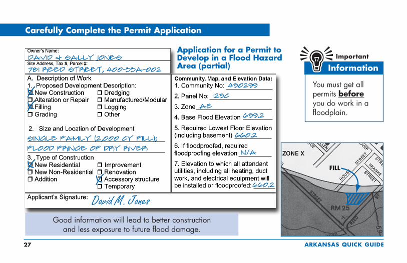
Carefully Complete the Permit ApplicationCarefully Complete the Permit Application
Good information will lead to better construction and less exposure to future flood damage.
X
David & Sally Jones
78i Reed Street, 400-33A-002
David M. Jones
You must get all permits before you do work in a floodplain.
X
Single Family (2,000 cy fill); flood fringe of Dry River
XX
Application for a Permit to Develop in a Flood Hazard Area (partial)
450299i25c
AE659.2
660.2
N/A
660.2

ARKANSAS QUICK GUIDE 2�
Freeboard: Go the Extra Foot!
The Arkansas Natural Resources Commission recommends that the lowest floor of all new buildings and substantially improved buildings be elevated at least one foot above the BFE. Remember, upstream developments as well as uncertainty may result in higher flood levels in the future.
NOTE: Flood insurance rates and various fees change from time to time. Rather than specific costs for insurance, this figure gives a feel for how much difference just a foot or two can make.
Building owners will save insurance money if they elevate above the BFE. But more impressive is how the cost of insurance can more than double if the building is only one foot below the BFE.
Remember! The community may be able to grant a variance, but the owner will probably still be required to buy insurance. Imagine trying to sell a house if the bank requires insurance that costs over $2,000 a year!
Freeboard: Go the Extra Foot!
ARKANSAS QUICK GUIDE 2�
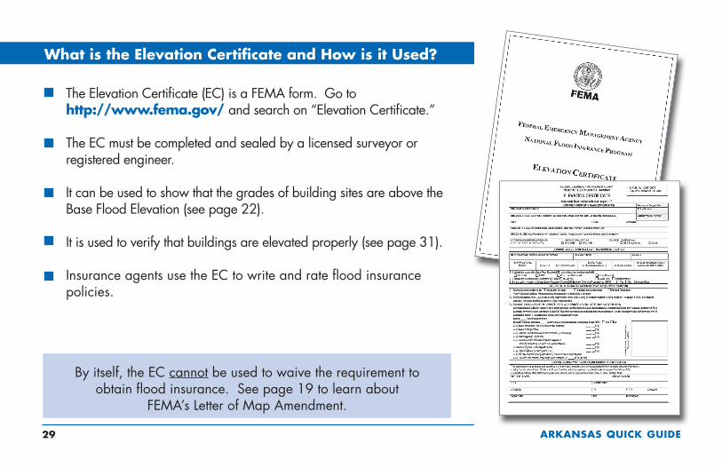
What is the Elevation Certificate and How is it Used?
The Elevation Certificate (EC) is a FEMA form. Go to http://www.fema.gov/ and search on “Elevation Certificate.”
The EC must be completed and sealed by a licensed surveyor or registered engineer.
It can be used to show that the grades of building sites are above the Base Flood Elevation (see page 22).
It is used to verify that buildings are elevated properly (see page 31).
Insurance agents use the EC to write and rate flood insurance policies.
By itself, the EC cannot be used to waive the requirement to obtain flood insurance. See page 19 to learn about
FEMA’s Letter of Map Amendment.
What is the Elevation Certificate and How is it Used?

ARKANSAS QUICK GUIDE �0
Completing the Elevation Certificate
You will get a blank Elevation Certificate form when you get your permit. You must have a surveyor or engineer fill it out and seal it. The Elevation Certificate includes diagrams for eight building types.
Several points must be surveyed.
In this example, the BFE is 625.
The slab-on-grade house was elevated on fill 1 foot above the BFE, and the vented garage is 2.5 feet below the BFE.
ELEVATION CERTIFICATE (partial)
RM55626 0n/a
622 5
TWELVE1,280
n/a
X
626 0
626 0622 5

ARKANSAS QUICK GUIDE ��
If you get a permit to build in the floodplain, you will be given an Elevation Certificate form. As soon as your lowest floor is set, get the form filled out and sealed by a surveyor or engineer.
This form is important! It proves that you built correctly, and it can be used to obtain the correct insurance rating.
Paperwork is Important – for You and Your Community
Lowest Floor means the lowest floor of the lowest enclosed area (including basement). An unfinished or flood-resistant enclosure (that is not a basement) is not the lowest floor if the enclosure is built as required in the local ordinance (see page 37), which includes limited uses.

ARKANSAS QUICK GUIDE �2
Floodplain Fill Can Make Things Worse
Floodplains are supposed to store floodwater. If storage space is filled with fill material, future flooding may be worsened. Your community may require an engineering analysis
(“no impact” certificate) to show how floodplain fill will alter flooding. Floodplain fill can alter valuable floodplain functions, including wildlife habitat and wetlands.
Make sure your floodplain fill project won’t harm your neighbors. Floodway fill is allowed only if an engineering evaluation demonstrates that “no impact” or “no rise” in flood level will occur (see page 33).

ARKANSAS QUICK GUIDE ��
The engineering analysis must be based on technical data approved by FEMA. Save time and money – don’t build in the floodway!
Floodways can be dangerous because water may flow very fast.
Development is not allowed unless “no impact” (“no rise”) in flood elevations, floodway elevations, and floodway widths is certified.
An engineer must evaluate the hydraulic impact of proposed development.
A “no impact” or “no rise” certification is required and must be signed, sealed, and dated by a registered professional engineer.
Check with your community for guidance before you decide to work in a floodway.
Required Floodway “No Impact” Certification

ARKANSAS QUICK GUIDE ��
CAUTION! Enclosures (including crawlspaces) have some special requirements (see pages 37 and 38). Note: When the walking surface of the lowest floor is at the minimum elevation, under-floor utilities
are not allowed. Fill used to elevate buildings must be placed properly (see page 35).
How to Elevate Your Floodplain Building

ARKANSAS QUICK GUIDE �5
Earthen fill used to raise the ground above the flood elevation must be placed properly so that it does not erode or slump when water rises. For safety and to meet floodplain requirements, floodplain fill should:
Be good clean soil, free of large rocks, construction debris, and woody material (stumps, roots).
Be machine-compacted to 95 percent of the maximum density (determined by a design professional).
Have graded side slopes that are not steeper than 2:1 (one foot vertical rise for every 2 feet horizontal extent); flatter slopes are recommended.
Have slopes protected against erosion (vegetation for “low” velocities, durable materials for “high” velocities – determined by a design professional).
Your community may ask for certification of the elevation, compaction, slope, and slope protection materials. Your engineer or design professional can find more information in FEMA’s technical guidance (MT-1).
Compaction of Floodplain Fill

ARKANSAS QUICK GUIDE ��
Manufactured Homes Require Special Attention
Manufactured homes must be anchored to resist flotation, collapse, or lateral movement by being tied down in accordance with your community’s ordinance or the manufacturers’ installation specifications.
Experience shows that manufactured homes are easily damaged. As little as 1 foot
of water can cause substantial damage.
Dry stacked blocks are not acceptable — they will NOT
withstand a flood.
Manufactured Homes Require Special Attention

ARKANSAS QUICK GUIDE ��
Solid perimeter wall foundations can enclose flood-prone space. A crawlspace is a good way to elevate just a couple of feet. In all cases, the following are required: vents/openings,
elevated utilities, flood-resistant materials, and limitations on use.
Enclosures Below the BFE
NOTE:Total net area of all total openings is 1 sq. in. per sq. ft. of enclosed area
A 25’ x 45’ building needs 1,125 sq. inches of openings
Standard ventilation units used in block foundation walls must be disabled in the open position to allow water to flow in and out
A standard ventilation unit, with screen, provides 42 to 65 sq. inches of opening
ALTERNATIVE: Engineered openings are acceptable if certified to allow adequate automatic inflow and outflow of floodwaters.

ARKANSAS QUICK GUIDE ��
Crawlspace Details
The Lowest Floor Elevation must be at or above the BFE.
The bottom of flood vents/openings must be no more than 1 foot above grade.
Standard ventilation units must be disabled in the “open” position to allow water to flow in and out.
Interior grade must be equal to or higher than exterior grade on at least one side.
Calculate Net Flood Opening:A building that measures 25’ x 45’ has 1,125 square feet of enclosed crawlspace. Flood vents must provide 1,125 sq. in. of net open area (or have certified engineered openings). If a standard air vent unit provides 60 sq. in. of net open area, then to satisfy the flood opening requirement 19 vent units are required (1,125 divided by 60).

ARKANSAS QUICK GUIDE ��
Basements Are Unsafe
Basements below the BFE are not allowed in new development and flood insurance coverage is very limited in existing basements for a very good reason. It only takes an inch of water over the sill and the entire basement fills up! Excavating a basement into fill doesn’t always make it safe because saturated groundwater can damage the walls.
A basement is any portion of a building that has its floor sub-grade (below ground level) on all sides.
Basements Are Unsafe

ARKANSAS QUICK GUIDE �0
Utility Service Outside Buildings
Whether inside an attached garage or outside the building, all utilities, appliances and equipment must be elevated above the BFE or protected against flood damage. Utilities include plumbing,
electrical components, gas lines, fuel tanks, and heating and air conditioning equipment.
Fuel and propane tanks may cause explosion and pollution risks during flood conditions! Even shallow water can create large buoyant forces on tanks, so extra care must be taken to ensure that all tanks are anchored.
HEAT PUMP OR A/CON PLATFORM
FUEL OR PROPANE TANKANCHORED TO PREVENT FLOTATION
FUEL OR PROPANE TANKANCHORED ON PLATFORM
Utility Service Outside Buildings

ARKANSAS QUICK GUIDE ��
All utilities, appliances, and equipment must be elevated above the BFE or protected. Utilities include plumbing, electrical components, gas lines, and heating and air conditioning equipment.
Utility Service Inside Enclosures

ARKANSAS QUICK GUIDE �2
Accessory (Appurtenant) Structures
Even small buildings are “development” and permits or variances with noted conditions are required. They must be elevated or anchored and built to withstand flood damage.
Caution! Remember, everything inside is likely to get wet when flooding occurs.
Not habitable
Used only for parking or storage (not pollutants or hazardous materials)
Anchored to resist floating
Flood vents/openings
Built of flood-resistant materials
Elevated utilities
Cannot be modified for different use in the future
Documented floor elevation
Accessory (Appurtenant) Structure means a structure that is located on the same parcel of land as a principal structure and whose use is incidental to the use of the principal structure. Accessory structures may not be used for human habitation and must be designed to minimize flood damage. Examples: detached garages, carports, storage sheds, pole barns, and hay sheds.
Accessory (Appurtenant) Structures

ARKANSAS QUICK GUIDE ��
Recreational VehiclesRecreational Vehicles
RVs that do not meet these conditions must be installed and elevated like Manufactured Homes, including permanent foundations and tie-downs (see page 36).
Camping near the water? Ask the campground or RV park operator
about flood warnings and plans for safe evacuations.
In a flood hazard area, an RV must:
Be licensed and titled as an RV or park model (not as a permanent residence)
Be built on a single chassis
Have inflated wheels and be self-propelled or towable by light truck
Have no attached deck, porch, or shed
Be used for temporary recreational, camping, travel, or seasonal use (no more than 180 days)
Have quick-disconnect sewage, water, and electrical connectors

ARKANSAS QUICK GUIDE ��
To obtain a permit to improve an existing building:You must provide a copy of your construction contract or a cost estimate (including estimated market value of your own or donated labor and materials).Your community will compare the cost of the proposed work to the market value of your building and check the value of improvements.You may submit an independent assessment of the market value of the building, if performed by a qualified professional.If the cost of the improvement (or if the proposed work plus improvements) equals or exceeds 50% of the market value of the building, you must comply with the Substantial Improvement requirements.If the costs do not trigger Substantial Improvement requirements, then you should still consider ways to reduce future damage (see page 45).
Planning to Improve Your Floodplain Building?Planning to Improve Your Floodplain Building?
Improvements include:
Renovation/rehabilitation of the interior of the existing building (see page 46)
Lateral addition, without renovation or structural alteration of the existing building (see page 47)
Lateral addition, with renovation or structural alteration of the existing building (see page 48)
Vertical addition (add new story).
Substantial improvement means any reconstruction, rehabilitation, addition, or other improvement of a structure, the cost of which equals or exceeds 50% of the market value of the structure before the start of construction of the improvement. This term includes structures which have incurred substantial damage, regardless of the actual repair work performed (see page 49).

ARKANSAS QUICK GUIDE �5
Your proposed improvements are “non-substantial” if the costs of all improvements are less than 50% of the market value of the building. Although you are not required to bring the existing building into compliance, there are many things you can do to reduce future flood damage. Find out the BFE at your location and consider the following:
Use flood resistant materials, for example tile, closed-cell wall insulation, and polyvinyl wall coverings.
Raise air conditioning equipment, heat pump, furnace, hot water heater, and other appliances on platforms.
Install electrical outlets higher above the floor.
Move ductwork out of crawlspaces.
Retrofit crawlspaces with flood openings.
Fill in below-grade crawlspaces/ utility space.
Note! Be sure to include ALL proposed work in your initial permit application. If you add more work after the permit is issued, your community will make another evaluation for Substantial Improvement.
Non-Substantial Improvements

ARKANSAS QUICK GUIDE ��
Substantial Improvement: Renovation Only
Floodplain buildings can be improved, renovated, rehabilitated or altered, but special rules apply.
Check with your local permit office and the Arkansas Natural Resources Commission before you begin. It will be easier to do it right the first time.
The cost to correct previously cited violations of state or local health, sanitary, or safety codes to provide safe living conditions can be excluded from the cost of renovations.
Alteration of a registered historic structure is allowed, as long as it will continue to meet the criteria for listing as a historic structure.
EXISTING BUILDING
RENOVATED/REHABILITATEDBUILDING

ARKANSAS QUICK GUIDE ��
Substantial Improvement: Lateral Addition Only
You must get a permit from your community to build an addition to your floodplain building. If the existing building is not already properly elevated, then only the addition must be built with the lowest floor at or above the Base Flood Elevation provided:
You make no interior modifications to the existing building; and
You make no structural modifications to the existing common wall other than adding a connecting doorway.
See page 48 if your project to add a lateral addition also includes modifying the interior of the existing building or making structural modifications to the existing common wall.

ARKANSAS QUICK GUIDE ��
Substantial Improvement: Addition Plus Other Work
Your community must prepare an evaluation to determine if all of your proposed work will trigger the Substantial Improvement requirement. Substantial Improvement is triggered if:
The work involves adding a new top floor, modifying the interior of the existing building, or structural modifications to the existing common wall (for lateral addition); and
The cost of all proposed work plus the cost of improvements equals or exceeds 50% of the market value of the existing building.
Your community’s permit office can help you determine which requirements apply. It is always a good idea to request a preliminary review
before you get too far along with your plans.

ARKANSAS QUICK GUIDE ��
What About After Damages?What About After Damages?
A permit is required to repair substantial damage from any cause — fire, flood, wind, or even a truck running into a building. Check with your community permit office to be sure.
You will be asked to provide a detailed cost estimate for repairs. See page 51 for more information about elevating an existing building above a crawlspace.

ARKANSAS QUICK GUIDE 50
You may be eligible for up to $30,000 to help pay to protect your building from future flood damage – to bring it into compliance with your community’s floodplain requirements – if:
You have NFIP flood insurance – it includes Increased Cost of Compliance (ICC), coverage.
Your building is in the mapped Special Flood Hazard Area.
Your community has made an official determination that the building was substantially damaged by flooding.
You act quickly to process all the required paperwork.
Paying for Post-Flood Compliance
Owners whose buildings are substantially damaged are required to “bring the building into compliance” with floodplain requirements. Substantial damage
is a special case of substantial improvement (see pages 44 and 49).
Paying for Post-Flood Compliance

ARKANSAS QUICK GUIDE 5�
Elevating a Pre-FIRM BuildingElevating a Pre-FIRM Building
This is one way to elevate an existing building to comply with floodplain regulations. If your insured building is damaged by flood and your community determines it is substantially damaged, you may be
eligible for an Increased Cost of Construction payment (see page 50). The state and FEMA can help with more information and options.

ARKANSAS QUICK GUIDE 52
Move water heaters, furnaces, and ductwork out of basements. Anchor heating oil and propane gas tanks to prevent flotation. Do not store valuables in a flood-prone crawlspace or basement.
Use water-resistant materials when you repair.
Some Flood Protection for Older Homes is Easy and Low Cost

ARKANSAS QUICK GUIDE 5�
In areas where floodwaters aren’t expected to be deep, sometimes individual buildings can be protected by earthen levees or concrete floodwalls. You must get a permit for those protection measures, and extra care must be taken if the site is in a Floodway (see pages 12, 32 and 33). A levee or floodwall cannot be used
to protect a new or substantially improved building, or one that is repaired after substantial damage. Important! These protective measures will not reduce your flood insurance premium!
Small Levees and Floodwalls Can Protect Some Older Homes

ARKANSAS QUICK GUIDE 5�
But Give You More Protection
After floods, some communities buy out and demolish homes that were severely damaged. The acquired land is dedicated to open space and can be used for recreation or to help restore
wildlife habitat and wetlands. Homes have been raised up on higher foundations, and others have been moved to safer high ground.
Some Flood Mitigation Projects are More Costly

ARKANSAS QUICK GUIDE 55
Useful Resources and Common AcronymsUseful Resources and Common Acronyms
Useful Resources
For information on disaster safety, being prepared, and repairing homes, click on Disaster Services when you visit the American Red Cross webpage at http://www.redcross.org.
FEMA has developed materials to help families and businesses learn more about preparing for floods and recovering from disasters at http://www.fema.gov/library.
Arkansas Natural Resources Commission: http://www.anrc.arkansas.gov
Arkansas Department of Emergency Management: http://www.adem.state.ar.us
Arkansas Department of Environmental Quality: http://www.adeq.state.ar.us
Arkansas Department of Insurance: http://insurance.arkansas.gov
Arkansas Floodplain Management Association: http://www.arkansasflood.com
Common Acronyms
BFE = Base Flood Elevation
EC = Elevation Certificate
FEMA = Federal Emergency Management Agency
FIRM = Flood Insurance Rate Map
ICC = Increased Cost of Compliance
NFIP = National Flood Insurance Program
SFHA = Special Flood Hazard Area

ARKANSAS QUICK GUIDE 5�
Want to Learn More?
For advice on flood information and permits, call your community’s building permit office, engineering, or planning department.
To order flood maps, call FEMA’s Map Service Center – (800) 358-9616 or enter the FEMA Map Store to order online at http://store.msc.fema.gov.
To learn more about flood maps and to check the Status of Map Change Requests, click on “Flood Hazard Mapping” at http://www.fema.gov.
FEMA’s online publications can be found in the FEMA Virtual Library. Many are posted in the Portable Document Format (PDF). Go to http://www.fema.gov for more information. You can order printed copies of FEMA publications from the FEMA Distribution Center, at (�00) ��0-2520.
To learn about flood insurance, call your insurance agent. Most insurance companies can write an NFIP policy for you. If you need more help, call the National Flood Insurance Program’s toll free number to get the name of an agent in your area who does write flood insurance. The number is (���) �5�-��2�.
To get the best rates for flood insurance, call a local surveyor to complete an Elevation Certificate.
Find out about online Elevation Certificate training for surveyors by going to http://www.fema.gov and searching on “Elevation Certificate.”