Chapter 8: Urban Design and Visual Resources A. INTRODUCTION · 2012-10-25 · Chapter 8: Urban...
31
8-1 Chapter 8: Urban Design and Visual Resources A. INTRODUCTION This chapter considers the effects of the proposed project on urban design and visual resources. The proposed project would result in the rehabilitation and redevelopment of the historic Pier 57 structure in Hudson River Park—a vacant building listed on the State/National Registers of Historic Places—with new public open space, retail, restaurant and other commercial uses, as well as educational and cultural uses, accessory parking, and a marina. Under the 2012 City Environmental Quality Review (CEQR) Technical Manual, urban design is defined as the totality of components that may affect a pedestrian’s experience of public space. These components include streets, buildings, visual resources, open spaces, natural resources, wind, and sunlight. An urban design assessment under CEQR must consider whether and how a project may change the experience of a pedestrian in a project area. The CEQR Technical Manual guidelines recommend the preparation of a preliminary assessment of urban design and visual resources, followed by a detailed analysis, if warranted based on the conclusions of the preliminary assessment. The analysis provided below addresses urban design characteristics and visual resources for existing conditions and the future without and with the proposed project (the No Action and With Action condition, respectively). PRINCIPAL CONCLUSIONS Overall, this analysis concludes that the proposed project would not have any significant adverse impacts related to urban design and visual resources. B. METHODOLOGY Based on the CEQR Technical Manual, a preliminary assessment of urban design and visual resources is appropriate when there is the potential for a pedestrian to observe, from the street level, a physical alteration beyond that allowed by existing zoning. Examples include projects that permit the modification of yard, height, and setback requirements, and projects that result in an increase in built floor area beyond what would be allowed ‘as‐of‐right’ or in the future without the proposed project. The proposed project would require a rezoning of the project site from M2-3 to M1-5—which would allow for additional floor area to be developed—as well as relief from various waterfront zoning regulations related to bulk, height, setback, yards, public access, visual corridors, and design requirements, and other actions. The project also would require state and federal discretionary actions related to the development of the proposed marina and other in-water work. As a result of these actions, Pier 57 would undergo a physical alteration observable by pedestrians that is not allowed by existing zoning. Therefore, the proposed project meets the threshold for a preliminary assessment of potential impacts to urban design and visual resources.
Transcript of Chapter 8: Urban Design and Visual Resources A. INTRODUCTION · 2012-10-25 · Chapter 8: Urban...

8-1
Chapter 8: Urban Design and Visual Resources
A. INTRODUCTION This chapter considers the effects of the proposed project on urban design and visual resources. The proposed project would result in the rehabilitation and redevelopment of the historic Pier 57 structure in Hudson River Park—a vacant building listed on the State/National Registers of Historic Places—with new public open space, retail, restaurant and other commercial uses, as well as educational and cultural uses, accessory parking, and a marina.
Under the 2012 City Environmental Quality Review (CEQR) Technical Manual, urban design is defined as the totality of components that may affect a pedestrian’s experience of public space. These components include streets, buildings, visual resources, open spaces, natural resources, wind, and sunlight. An urban design assessment under CEQR must consider whether and how a project may change the experience of a pedestrian in a project area. The CEQR Technical Manual guidelines recommend the preparation of a preliminary assessment of urban design and visual resources, followed by a detailed analysis, if warranted based on the conclusions of the preliminary assessment. The analysis provided below addresses urban design characteristics and visual resources for existing conditions and the future without and with the proposed project (the No Action and With Action condition, respectively).
PRINCIPAL CONCLUSIONS
Overall, this analysis concludes that the proposed project would not have any significant adverse impacts related to urban design and visual resources.
B. METHODOLOGY Based on the CEQR Technical Manual, a preliminary assessment of urban design and visual resources is appropriate when there is the potential for a pedestrian to observe, from the street level, a physical alteration beyond that allowed by existing zoning. Examples include projects that permit the modification of yard, height, and setback requirements, and projects that result in an increase in built floor area beyond what would be allowed ‘as‐of‐right’ or in the future without the proposed project.
The proposed project would require a rezoning of the project site from M2-3 to M1-5—which would allow for additional floor area to be developed—as well as relief from various waterfront zoning regulations related to bulk, height, setback, yards, public access, visual corridors, and design requirements, and other actions. The project also would require state and federal discretionary actions related to the development of the proposed marina and other in-water work. As a result of these actions, Pier 57 would undergo a physical alteration observable by pedestrians that is not allowed by existing zoning. Therefore, the proposed project meets the threshold for a preliminary assessment of potential impacts to urban design and visual resources.

Pier 57 Redevelopment
8-2
As described above, urban design is the totality of components that may affect a pedestrian’s experience of public space. This assessment considers the effects of the proposed project on the experience of a pedestrian in the study area. The assessment focuses on those project elements that have the potential to alter the built environment, or urban design, of the project area, which is collectively formed by the following components:
• Streets—the arrangement and orientation of streets define location, flow of activity, street views, and create blocks on which buildings and open spaces are arranged. Other elements including sidewalks, plantings, street lights, curb cuts, and street furniture also contribute to an area’s streetscape.
• Buildings—a building’s size, shape, setbacks, pedestrian and vehicular entrances, lot coverage and orientation to the street are important urban design components that define the appearance of the built environment.
• Visual Resources—visual resources include significant natural or built features, including important view corridors, public parks, landmark structures or districts, or otherwise distinct buildings.
• Open Space—open space includes public and private areas that do not include structures, including parks and other landscaped areas, cemeteries, and parking lots.
• Natural Features—natural features include vegetation, and geologic and aquatic features that are natural to the area.
According to the CEQR Technical Manual, the study area for urban design is the area where the project may influence land use patterns and the built environment, and is generally consistent with that used for the land use analysis. For visual resources, the view corridors within the study area from which such resources are publicly viewable should be identified. The land use study area may serve as the initial basis for analysis; however, in cases where significant visual resources exist, it may be appropriate to look beyond the land use study area to encompass views outside of this area, as is often the case with waterfront sites or sites within or near historic districts. The project site is located on the Hudson River waterfront. Consistent with the analysis of land use, zoning, and public policy, the study area for the urban design and visual resources analysis has been defined as a ¼-mile radius around the project site (see Figure 8-1). Longer views from the Hudson River itself are also considered.
The CEQR Technical Manual recommends an analysis of pedestrian wind conditions for projects that result in the construction of large buildings at locations that experience high wind conditions (such as along the waterfront, or other location where winds from the waterfront are not attenuated by buildings or natural features), which may result in an exacerbation of wind conditions due to “channelization” or “downwash” effects that may affect pedestrian safety. The proposed project would not involve any substantial new building construction that could affect wind conditions, and thus a pedestrian wind analysis is not warranted.

10 A
V
W 15 ST
W 16 ST
W 17 ST
W 18 ST
W 19 ST
W 20 ST
W 21 ST
9 AVW 13 ST
HORATIO ST
JOE
DIM
AGG
IO H
WY
WAS
HING
TON
ST
GANSEVOORT ST
LITTLE W 12 ST
JOE
DIM
AGG
IO H
WY
HU
DS
ON
R
IV
ER
2.24
.12
HUDSON RIVER PARK PIER 57
Urban Design and Visual ResourcesReference Map
Figure 8-1
SCALE
0 800 FEET
N
CHELSEA
1
PIER 62
PIER 61
PIER 60
PIER 59
PIER 57
PIER 54
PIER 53
PIER 52
3
188
9
146
17
1611
21
22
20
19
121
75
2
1023
4
15
13
Project Site Boundary
Study Area Boundary (1/4-Mile Perimeter)
Photograph View Directionand Reference Number
High Line

Chapter 8: Urban Design and Visual Resources
8-3
C. EXISTING CONDITIONS
URBAN DESIGN
PROJECT SITE
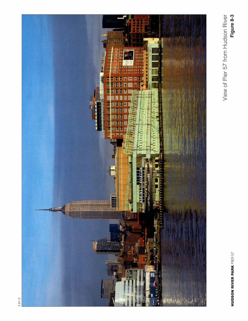
The project site consists of Pier 57, adjacent lands underwater, and associated frontage area, all located within Hudson River Park at approximately West 15th Street. The portion of the pier that extends into the river (the pier shed) is 725 feet long and 150 feet wide; the perpendicular portion that fronts along Eleventh Avenue (the head house) is 375 feet long and 150 feet wide. The pier shed is two stories (approximately 67 feet) tall and approximately 300,000 square feet in size. The pier’s rectangular-plan, flat-roofed headhouse faces onto Eleventh Avenue and is clad in brick with stone trim around a central bank of tall window openings (see View 1 of Figure 8-2). The first floor has regularly spaced door openings with rolling metal shutters. The building name Marine & Aviation Pier 57 appears in stainless steel lettering above the central bank of windows on the headhouse facade. Wings extend to the north and south of the central section; these feature horizontal bands of windows at the upper floors. The portion of the pier shed that extends into the river is clad in metal, with vertical lift doors on both the first and second floors and regularly-spaced, steel-sash fenestration (see View 2 of Figure 8-2). Attached along the roof edge on the north and south façades are metal frameworks originally used for cargo handling, referred to as “burtons.” Currently, the flat roof is paved and includes two central stair and elevator bulkheads and two smaller stair bulkheads. An approximately 14-foot-wide walkway extends around most of the pier shed’s perimeter, but does not continue along the north and south ends of the head house’s wings, and thus does not connect to adjacent portions of the Hudson River Park waterfront esplanade. The west end (foot house) of the pier has rounded, streamlined corners clad in steel, and the name Pier 57 appears in large stainless steel letters on the upper band (see Figure 8-3). The pier, which is listed on the State and National Registers of Historic Places, has been vacant since 2004. To the east of the pier are a paved apron area and the adjacent Hudson River Park waterfront esplanade and Route 9A bikeway. The pier is currently built to an FAR of approximately 1.8; the allowable FAR of the site’s existing zoning is 2.0.
STUDY AREA
The ¼-mile study area is roughly bounded by Pier 61 of Chelsea Piers and West 21st Street to the north, Ninth Avenue to the east, and Gansevoort Street and Pier 52 on the Gansevoort Peninsula to the south. The study area’s street pattern differs above and below West 14th Street. Below West 14th Street, the streets follow the irregular pattern found in the West Village, which creates smaller, irregularly-shaped blocks. Above West 14th Street, the street pattern is the more regular grid found throughout much of Manhattan, which creates long, rectangular blocks between Ninth and Tenth Avenues. Eleventh Avenue cuts through the study area parallel with Manhattan’s western shoreline, creating irregularly-shaped blocks west of Tenth Avenue. The elevated High Line Park, which is described in greater detail below, also cuts a winding path through the study area west of Ninth Avenue and is a prominent feature in surrounding views. The topography of the study area is generally flat, with a very slight rise from south to north and heading east from the shoreline.
Route 9A, which runs along the Hudson River waterfront east of the project site, is the main vehicular thoroughfare in the study area. Opposing lanes of traffic are separated by a well-

Figure 8-2HUDSON RIVER PARK PIER 57
Photographs of Project Site
3.20.12
2Pier 57 pier shed, view from waterfront esplanade
1Pier 57 head house, view from Route 9A
HU
DS
ON
RIV
ER
PA
RK
PIE
R 5
7Fi
gu
re 8
-3
3.20
.12
View
of P
ier 5
7 fro
m H
udso
n R
iver

Pier 57 Redevelopment
8-4
landscaped median with trees and bushes (see View 3 of Figure 8-4). The medians also provide decorative mast-arm lampposts and queuing areas for pedestrians. Route 9A’s crosswalks are also wide and well-painted. Route 9A carries the heaviest traffic volumes in the study area. Ninth and Tenth Avenues also carry a heavy amount of vehicular traffic, as does West 14th Street; other study area streets are less active, and thus quieter. The streets most highly used by pedestrians are Ninth Avenue and West 14th Street. A number of streets in the study area have Belgian block paving, including Little West 12th Street and portions of West 13th, 14th, and 17th Streets and Ninth Avenue. There is a protected bike path on Ninth Avenue north of West 14th Street, and marked bike paths on West 18th between Tenth and Eleventh Avenues, West 20th and 21st Streets east of Tenth Avenue, and Ninth Avenue/Greenwich Street, Washington Street, and Hudson Street south of West 14th Street. In addition, the intersection of Ninth Avenue and West 14th Street was recently redesigned to provide better-defined pedestrian crossings and additional paved plaza areas, which include large blocks of granite, landscaped planters, and tables and chairs shaded by umbrellas (see View 4 of Figure 8-4).
Other than retail and restaurant uses, which are described below, much of the pedestrian activity in the study area is oriented toward Hudson River Park and High Line Park. Hudson River Park occupies the land between Route 9A and the waterfront. The majority of the park is linear, expanded by several redeveloped piers, and upon completion will extend continuously from Battery Place to West 59th Street. Hudson River Park includes the waterfront esplanade, a pedestrian path that extends along the entire length of the park, and adjacent to the park is the Route 9A bikeway, a bike path that also extends along the entire length of the park (see View 5 of Figure 8-5). Decorative metal lampposts are used within the median separating Route 9A from the pedestrian and bike paths. A portion of Pier 54, just south of the project site, is currently open to the public. The pier is paved and marked by its arched metal entryway along Route 9A. Within the park, just north and south of Pier 57, there are pile fields—remnants of former piers—which are evocative of the City’s maritime history (see View 6 of Figure 8-5).
The 14th Street Park occupies the full block bounded by West 14th and 15th Streets and Tenth and Eleventh Avenues. It is separated from Hudson River Park by Route 9A, but is part of that park and serves to connect the waterfront to the surrounding commercial and residential uses. The 14th Street Park is composed of a grass oval surrounded by trees and seating and bordered by a low metal fence. Entrances to the park are marked by decorative metal archways (see View 7 of Figure 8-6).
The High Line Park is a new park created by the redevelopment of an elevated former freight line stretching from Gansevoort Street to West 30th Street. The park is landscaped with grasses, shrubs, and trees along concrete pathways at an elevation of approximately 25 feet (see View 8 of Figure 8-6). Ground-level access points for the High Line within the study area are located at Washington and Gansevoort Streets (the southern terminus of the park and rail line) and just west of Tenth Avenue at West 14th, 16th, 18th, and 20th Streets.
Along the Hudson River, the area south of Pier 54 is occupied by Piers 52 and 53 and the rest of the Gansevoort Peninsula, which extends from Gansevoort Street to Little West 12th Street. This approximately six-acre site is currently occupied by the City’s municipal sanitation operation and the New York Fire Department (FDNY) Marine Company One. There is truck parking and salt storage on the site, as well as a large, light-brown, utilitarian brick building surrounded by landscaping at its eastern edge. To the north of Pier 57 and the pile field are Piers 59, 60, and 61, which are part of the Chelsea Piers complex. The Chelsea Piers complex is 28 acres in size and includes a variety of recreational and event uses, as well as a marina. From the surrounding area,

Figure 8-4HUDSON RIVER PARK PIER 57
3.20.12
Photographs of Project Site and Study Area
4Intersection of Ninth Avenue and West 14th Street, view north
3Route 9A, view south towards project site

Figure 8-5HUDSON RIVER PARK PIER 57
3.20.12
Photographs of Study Area
6Pile field north of Pier 57
Route 9A bikeway, view south near project site 5

Figure 8-6HUDSON RIVER PARK PIER 57
3.20.12
Photographs of Study Area
8View from High Line Park, looking south through study area
714th Street Park entrance

Chapter 8: Urban Design and Visual Resources
8-5
Chelsea Piers is most noticeable for its tall netting enclosing a multi-level golf driving range, and its painted-blue and metal-clad, industrial facade along Route 9A (see View 9 of Figure 8-7).
Inland, the visual character of the study area varies and is defined generally by the areas south of West 14th Street, around the High Line north of West 17th Street, and along West 20th and 21st Streets between Ninth and Tenth Avenues. South of West 14th Streets, there are a number of historic, low-scale, brick industrial and warehouse structures formerly used for meatpacking and other similar uses, which are currently in use as retail, restaurants, residences, hotels, art galleries, and studios. Many of these buildings are two and three stories in height, fully occupy their lots, are built to the lot line, and have entrances set above ground level, for ease of loading/unloading trucks. Many of the buildings also have loading docks and roll-down metal shutters covering building entrances; some also have broad metal canopies shielding the ground floor area from sun, rain and snow, to provide cover for workers loading and unloading materials (see View 10 of Figure 8-7). Some of the newer buildings in the study area have adopted this building feature. Portions of sidewalks within this area are in use as outdoor dining areas for restaurants.
The low-scale character of this area is occasionally interrupted by new large-scale, glass-clad buildings, usually for hotels and office buildings. These include the Standard Hotel, an 18-story (233-foot-tall) tower elevated across the High Line Park at the southwest corner of Washington and West 13th Streets (see View 11 of Figure 8-8). The Standard Hotel is clad in glass, brick and aluminum and has a roughly rectangular, angled floorplate. At ground level, the hotel includes a paved plaza with several types of outdoor seating for restaurants, as well as a 16-foot-tall sculpture by the artist KAWS of a mouse, entitled “Companion (Passing Through)”. The block south of the Standard Hotel, bounded by Washington Street and 10th Avenue to the east and west and Little West 12th and Gansevoort Streets to the north and south, houses the few remaining meat production and wholesale companies in the area. Other new structures in this portion of the study area include the 15-story, 192-foot-tall High Line building on West 14th Street near 10th Avenue, which is currently being completed and is projected for retail and office use, and the Hotel Gansevoort, a 14-story, 164-foot-tall, glass- and metal-clad building on the block bounded by Little West 12th, West 13th, and Hudson Streets and Ninth Avenue.
North of West 14th Street to roughly West 17th Street, the study area generally consists of large commercial buildings that fully occupy their lots, are built to the lot line, and are taller than the buildings south of West 14th Street. These include the former National Biscuit Company factory complex, which occupies the blocks bounded by Ninth and Eleventh Avenues and West 15th and 16th Streets. Ornamented metal skybridges over Tenth Avenue and West 15th Street connect several of these large red brick buildings, including the 11-story building directly east of the project site, which currently is in office use (see View 12 of Figure 8-8 and View 13 of Figure 8-9). The Chelsea Market facility is located in the 6- and 8-story red brick National Biscuit Company buildings between Ninth and Tenth Avenues, north of West 15th Street. The trapezoidal block bounded by Tenth and Eleventh Avenues and West 16th and 17th Streets is fully occupied by the historic Merchants Refrigerating Company Warehouse, an 11-story (131-foot-tall) buff-colored brick building designed in a simplified Renaissance Revival style.
North of the Merchants Refrigerating Company Warehouse, the west side of Tenth Avenue is generally lined with surface parking uses as far as West 20th Street. The block bounded by West 17th and 18th Streets and Tenth and Eleventh Avenues is entirely occupied by surface parking, which greatly opens up views to the surrounding area, including the High Line above and the Chelsea Piers complex along the water. Other new buildings that can be seen within this area

Figure 8-7HUDSON RIVER PARK PIER 57
3.20.12
Photographs of Study Area
10West 14th Street, view west from Ninth Avenue
9Chelsea Piers, view to north

Figure 8-8HUDSON RIVER PARK PIER 57
3.20.12
Photographs of Study Area
12Former National Biscuit Company complex, view north from West 14th Street and Tenth Avenue
11View to Standard Hotel and High Line Building from
Hudson River Park

Figure 8-9HUDSON RIVER PARK PIER 57
3.20.12
Photographs of Study Area
14View north to IAC Building and 100 Eleventh Avenue, from Hudson River Park
13Former National Biscuit Company complex and
skybridge, view west from Ninth Avenue
Pier 57 Redevelopment
8-6
include the Frank Gehry-designed IAC Building and the Jean Nouvel-designed 100 Eleventh Avenue building to the north, and the Caledonia at 450 West 17th Street to the south. The IAC Building, at 555 West 18th Street, is 10 stories (150 feet) tall and is composed of twisting towers of white-frosted glass (see View 14 of Figure 8-9). 100 Eleventh Avenue is 21 stories (250 feet) tall, with a curved façade consisting of a series of “megapanels” of glass, and a 7-story, free-standing street wall of mullioned glass at the intersection of Eleventh Avenue and West 19th Street. The Caledonia is a red brick- and glass-clad, 24-story (250-foot-tall) residential tower directly adjacent to the High Line Park before it crosses Tenth Avenue. The twisted, curved, and angled facades of the Gehry and Nouvel buildings, as well as the new 12-story Chelsea Modern building at 447 West 18th Street, differ from the rectilinear building massings found through most of the study area.
The west side of Ninth Avenue from West 16th Street north to West 19th Street, extending into the midblock, is occupied by the New York City Housing Authority (NYCHA) Fulton development. This complex includes three 25-story buildings set far back from the side streets, and seven six-story buildings set closer to the lot lines (see View 15 of Figure 8-10). Surrounding these buildings are paved areas with play equipment, landscaping, surface parking lots, and several smaller structures.
At the northeastern edge of the study area is the General Theological Seminary complex, which occupies most of the block bounded by West 20th and 21st Streets and Ninth and Tenth Avenues. A low brick wall surrounds the seminary complex on West 20th Street, opposite a series of attractive, low-scale residences, including rowhouses with stoops. Along West 21st Street, the neo-Gothic tower of the seminary’s Chapel of the Good Shepherd can be seen.
At various locations within the study area, there are buildings with large-scale advertising signage attached; there are also advertising billboards on scaffolding above several buildings at the intersection of West 14th Street and Ninth Avenue. Most of the street trees in the area are around the NYCHA Fulton development and General Theological Seminary complexes, and along Route 9A and Hudson River Park.
VISUAL RESOURCES
Visual resources are an area’s unique or important public view corridors, vistas, or natural or built features. These can include historic structures, parks, natural features (such as rivers), or important views.
PROJECT SITE
Pier 57 is considered a visual resource. The long metal-clad sides of the pier shed can be viewed from Route 9A and portions of Hudson River Park to the south and north, as well as from the Hudson River. From nearby portions of West 14th, 15th, and 16th Streets, the pier’s head house also can be seen. Views outward from the project site itself include long views north and south along Route 9A and Hudson River Park, the West 15th Street skybridge of the former National Biscuit Company complex, and the High Line Park as it crosses West 15th Street (see Views 16 and 17 of Figure 8-11).
STUDY AREA
As described above, the surface parking uses north of West 17th Street and west of Tenth Avenue provide wide views through this portion of the study area to surrounding buildings and

Figure 8-10HUDSON RIVER PARK PIER 57
3.20.12
Photographs of Study Area
15View west on West 17th Street, to Fulton Houses and Caledonia

HU
DS
ON
RIV
ER
PA
RK
PIE
R 5
7Fi
gu
re 8
-11
3.20
.12
View
s to
Vis
ual R
esou
rces
Vie
w n
orth
from
edg
e of
pro
ject
site
Vie
w e
ast f
rom
pro
ject
site
1716

Chapter 8: Urban Design and Visual Resources
8-7
the Hudson River waterfront. Long views are also available along Route 9A and the Hudson River Park waterfront esplanade and the adjacent Route 9A bikeway; views along this view corridor include the High Line, the ornamented metal skybridge above West 15th Street, and the various notable new and historic buildings along Eleventh Avenue that are described above.
Views throughout the study area also include the High Line Park: the ornamented metal viaduct carrying the former rail line, the extensive landscaping that is now planted in the elevated open space, and the people utilizing this resource (see View 18 of Figure 8-12). The viaduct carrying the park above the study area’s streets also serves to limit some views to other buildings and resources along these streets. Views from High Line Park itself are extensive in each direction, and are from an elevated perspective that is not typically available to pedestrians (see View 19 of Figure 8-12 as well as View 8 of Figure 8-6, above).
In general, westward views throughout the study area include the Hudson River waterfront and New Jersey in the far distance. Views west on West 13th Street include the Standard Hotel rising above and around the High Line. Views west on West 14th Street include the High Line, and Pier 57 also can be viewed through 14th Street Park (see View 20 of Figure 8-13). Views west on West 15th Street include the ornamented metal skybridge above that street and the High Line viaduct, as well as the head house of Pier 57 (see View 21 of Figure 8-13). Views east within the study area generally extend for long distances, except where the High Line viaduct or skybridges limit these views. On West 20th and 21st Streets, an extensive street tree canopy also limits views when the trees are in leaf. Views east on West 17th Street near Ninth Avenue include the sloping, metal-clad façade and porthole windows of the Maritime Building, and views east on West 21st Street include the chapel tower of General Theological Seminary.
View north on Washington Street ends with the buildings on the north side of West 14th Street because of the change in street pattern noted above. Views north on Tenth Avenue include the National Biscuit Company’s decorative metal skybridge, as well as the High Line viaduct (see View 22 of Figure 8-14). Views south along the avenue include these elements, as well as the Standard Hotel and the Goldman Sachs office tower in Jersey City in the far distance.
From the intersection of Ninth Avenue and West 14th Street, pedestrians can experience long views up and down the two intersecting view corridors of Ninth Avenue and Hudson Street (View 23 of Figure 8-15).
D. THE FUTURE WITHOUT THE PROPOSED PROJECT
PROJECT SITE
In the No Action condition, Pier 57 is expected to remain vacant. The project site would remain an underutilized component of Hudson River Park, and no new publicly accessible open space or commercial, educational, or cultural uses would be created. The historic Pier 57 structure and overwater platform would remain in their current condition, with some level of deterioration over time.
STUDY AREA
There are several developments under construction or planned in the study area that are expected to be completed by 2015. As described in detail in Chapter 2, “Land Use, Zoning and Public Policy,” these projects will replace existing industrial buildings and vacant lots with new

Figure 8-12HUDSON RIVER PARK PIER 57
3.20.12
Views to Visual Resources
19View from High Line Park, near West 14th Street
18View to High Line Park, from West 17th Street and
Tenth Avenue

Figure 8-13HUDSON RIVER PARK PIER 57
3.20.12
Views to Visual Resources
View west on West 15th Street to Pier 57 21
20View from High Line Park to Pier 57

Figure 8-14HUDSON RIVER PARK PIER 57
3.20.12
Views to Visual Resources
22View north on Tenth Avenue, from West 15th Street

Figure 8-15HUDSON RIVER PARK PIER 57
3.20.12
Views to Visual Resources
23View south from intersection of Ninth Avenue and West 14th Street

Pier 57 Redevelopment
8-8
buildings containing museum, office, and retail uses, as well as renovate and expand older industrial buildings for retail, hotel, and office uses.
E. PROBABLE IMPACTS OF THE PROPOSED PROJECT
URBAN DESIGN
The CEQR Technical Manual guidelines state that if the preliminary assessment shows that changes to the pedestrian environment are sufficiently significant to require greater explanation and further study, then a detailed analysis is appropriate. Examples include projects that would potentially obstruct view corridors, compete with icons in the skyline, or make substantial alterations to the streetscape of a neighborhood by noticeably changing the scale of buildings. Detailed analyses also are generally appropriate for areawide rezonings that include an increase in permitted floor area or changes in height and setback requirements, general large-scale developments, or projects that would result in substantial changes to the built environment of a historic district or components of a historic building that contribute to the resource’s historic significance.
The proposed project would not noticeably change the scale of buildings; would not involve an area-wide rezoning that includes an increase in permitted floor area or changes in height or setback requirements; would not involve a general large-scale development; and would not result in substantial changes to the built environment of a historic district. The proposed project would result in changes to a historic building, but as described below, these changes would not be characterized as substantial or adverse. Rather, the majority of the changes would involve restoring building elements and renovation.
As described in more detail in Chapter 7, “Historic and Cultural Resources,” the design of the proposed project is intended to respect the pier’s history, preserve and make accessible the structure’s existing fabric, as well as introduce a limited number of new, innovative architectural components to enliven the historic resource. The pier’s head house would be restored, to become an improved entrance into Hudson River Park from the Chelsea and Meatpacking District neighborhoods (see Figure 8-16). The water-side (foot house) façade also would be restored to its original appearance, and the modular vertical doors spanning the length of the pier shed would be restored (see Figure 8-17). The new uses within the pier shed would incorporate a small amount of exterior alterations. The exterior changes that would be visible to surrounding motorists, pedestrians, and park users—as well as boaters, ferry riders, and others using the Hudson River—would be the re-activation of the original vertical lift doors and “gangplanks” on the pier shed, a new sign at the head house entrance, and several new rooftop elements, including a pavilion with a public deck and shade structures. The shade structures would be mounted on rails, which could be moved manually in an east-west direction to provide shade where necessary. No new element on the rooftop would be taller than the height of the existing elevator bulkheads, however, and thus these changes would be minimally visible from the surrounding area (see Figure 8-18). The proposed project also would introduce two rooftop additions on the head house: one on the north side of the lower head house rooftop, and the other at the center of the upper head house rooftop. Both of the additions would be lower than the head house façade along Eleventh Avenue, but would be visible to pedestrians and bicyclists in Hudson River Park to the north and south of the project site. The head house additions would not noticeably change the scale of the existing structure, nor would they result in a substantial change to the pedestrian environment in Hudson River Park.

HUDSON RIVER PARK PIER 57 Figure 8-16
9.5.12
Pier Headhouse
Existing/No Action Condition
With Action Condition
Shade Structure
Existing Elevator Bulkhead
FOR ILLUSTRATIVE PURPOSES ONLY

HUDSON RIVER PARK PIER 57 Figure 8-17
9.5.12
Pier Foot House
Existing/No Action Condition
With Action Condition
Shade Structure
Existing Elevator Bulkhead
FOR ILLUSTRATIVE PURPOSES ONLY

HU
DS
ON
RIV
ER
PA
RK
PIE
R 5
7Fi
gu
re 8
-18
9.4.12
Roo
f Ele
vatio
n
Pro
pose
d S
hade
Str
uctu
reP
ropo
sed
Sha
de S
truc
ture
Pro
pose
d O
bser
vatio
n P
avili
onE
xist
ing
Bur
tons
Exi
stin
g E
leva
tor
Bul
khea
ds
Pro
pose
d S
tairw
ell
Pro
pose
d S
tairw
ell
Max
imum
Exi
stin
gB
uild
ing
Hei
ght
88’ A
bove
Bas
e P
lane

Chapter 8: Urban Design and Visual Resources
8-9
The proposed marina and water taxi landing would not involve any changes to the historic Pier 57 structure. The existing perimeter walkway extending around most of the pier would be repaired and extended to connect with the existing Hudson River Park waterfront esplanade to the east of the pier (see Figure 8-19). The walkway would have a continuous width of 15 feet and would include seating opportunities. New public walkways also would be constructed parallel to the existing bulkhead to widen the public park space adjacent to the busy circulation area in front of the project site. These new walkways would extend north and south just east of the head house (see Figure 8-20). While designed as part of the pier’s rehabilitation and referential to its historic character, these walkways and their associated railings and seating features also would be compatible with existing areas bordering the river within Hudson River Park. The provision of these new walkways, as well as the open spaces on the rooftop of the pier shed, would enhance the existing streetscape and pedestrian environment of Hudson River Park and Route 9A. The rehabilitated pier also would improve the visual and programming links between the Hudson River Park and inland communities, transforming the vacant pier into a handsome new component of Hudson River Park.
Figures 8-16 through 8-23 and Figures 1-4 through 1-16 in Chapter 1, “Project Description” illustrate how the project site and study area would appear in the With Action condition. As shown in these renderings, the restoration elements of the project and the small amount of proposed alterations would not substantially change the character of views to the resource. The proposed project would involve alterations to a historic structure, but would not result in substantial changes to components of the pier structure that contribute to its historic significance.
In summary, the proposed project does not meet any threshold that would merit further analysis of urban design, and would not result in significant adverse effects to urban design.
VISUAL RESOURCES
According to the guidance of the CEQR Technical Manual, additional visual resources analysis is required if: a project would partially or totally block a view corridor or a natural or built visual resource, and that resource is rare in the area or considered a defining feature of the neighborhood; or, a project would change urban design features so that the context of a natural or built visual resource is altered (for example, if a project alters the street grid so that the approach to the resource changes; if a project changes the scale of surrounding buildings so that the context changes; or if a project removes lawns or other open areas that serve as a setting for the resource). The proposed project would not partially or totally block a view corridor and would not change any urban design features such that the context of natural or built visual resources is substantially altered. The proposed project would reactivate Pier 57 and make alterations to the historic structure that would be appropriate and preserve the building’s historic integrity and improve its appearance. The proposed rooftop additions would be no taller than the existing elevator bulkheads, and thus would not present a notable change in views to the building for pedestrians and other park users. The proposed project would also provide opportunities for new views for pedestrians from the proposed rooftop open space and perimeter walkways. Therefore, the proposed project does not merit further analysis of visual resources, and would not result in significant adverse effects to visual resources.

HU
DS
ON
RIV
ER
PA
RK
PIE
R 5
7Fi
gu
re 8
-19
9.4.12
Illus
trativ
e R
ende
ring
of P
erim
eter
Wal
kway
FOR
ILLU
STRA
TIVE
PUR
POSE
S ON
LY

HU
DS
ON
RIV
ER
PA
RK
PIE
R 5
7Fi
gu
re 8
-20
9.4.12
Illus
trativ
e R
ende
ring
of P
erim
eter
Wal
kway
Ext
ensi
on
FOR
ILLU
STRA
TIVE
PUR
POSE
S ON
LY

HU
DS
ON
RIV
ER
PA
RK
PIE
R 5
7Fi
gu
re 8
-21
9.4.12
Aer
ial P
ersp
ectiv
e of
Pro
pose
d Pr
ojec
t
FOR
ILLU
STRA
TIVE
PUR
POSE
S ON
LY

9.4.12
HUDSON RIVER PARK PIER 57
ElevationsFigure 8-22
West Elevation East Elevation
South Elevation
North Elevation
FOR ILLUSTRATIVE PURPOSES ONLY