Chapter 3 - Visual Basic Schneider Chapter 3 Fundamentals of Programming in Visual Basic.

6-1
Chapter 6: Urban Design and Visual Resources
A. INTRODUCTION This chapter considers the potential of the proposed Memorial Sloan-Kettering Cancer Center (MSK)/The City University of New York (CUNY)-Hunter project to affect urban design and visual resources. The proposed project would occupy a largely vacant 66,111-square-foot (sf) site along the Franklin Delano Roosevelt Drive (FDR) Drive on the Upper East Side of Manhattan. It would replace remnants of a former garage and a surface parking lot with two modern structures immediately adjacent to each other appearing as a single composition totaling over one million gross square feet (gsf). The eastern building would reach a total height of approximately 450 feet while the western building would reach a height of approximately 350 feet.
As defined in the 2012 City Environmental Quality Review (CEQR) Technical Manual, urban design is the totality of components that may affect a pedestrian’s experience of public space. A visual resource can include views of the waterfront, public parks, landmark structures or districts, or otherwise distinct buildings, and natural resources. Consistent with the land use study area, this analysis considers a 400-foot study area (see Figures 6-1 and 6-2). Additional longer views from Roosevelt Island are considered given the visibility of the project site from Roosevelt Island’s waterfront esplanade. This analysis addresses the urban design and visual resources of the project site and study area for existing conditions, the future without the proposed project, and the future with the proposed project for the 2019 analysis year.
PRINCIPAL CONCLUSIONS
While a detailed analysis was undertaken due to the scale of the proposed buildings, the proposed project would not have significant adverse impacts related to urban design and visual resources on the project site and in the study area based on a number of considerations. The proposed project would not alter the arrangement, appearance, or functionality of the project site such that the alteration would negatively affect a pedestrian’s experience of the area. Rather, instead of a largely vacant and underutilized lot, the pedestrian would experience new buildings with active ground floors. East 74th Street with the main entrances to both structures would be improved with new street trees and landscaping. While East 73rd Street would be the location of both service entries, the facilities are designed such that trucks maneuver inside the buildings and the docks and storage areas are inside the buildings and out of pedestrian views.
Signs proposed for the north, east, and west façades and the building entrances on East 74th Street would be indirectly illuminated and non-flashing or not illuminated. The larger signs would be visible from a distance and not obtrusive to pedestrians. The smaller signs at the entrances would be wayfinding aids.
In addition, there are no visual resources on the project site and the proposed project would not block significant public views of the East River or the two known architectural resources and

YO
RK
AV
E.
E. 75TH ST.
E. 73RD ST.
E. 76TH ST.
E. 74TH ST.
E. 71ST ST.
E. 70TH ST.
E. 72ND ST.
FD
R D
R
EA
ST
R
IV
ER
11.28.12
N
MSK ACC | CUNY-HUNTER
Urban Design and Visual Resources Study Area Mapand Key to Photographs
Figure 6-1
SCALE
0 200 400 FEET
13 122 4
1
3
1
1098
5 6 11
7
Project Site Boundary
Study Area Boundary (400-Foot Perimeter)
Photograph View Direction and Reference Number

EA
ST
R
IV
ER
EA
ST
R
IV
ERY
OR
K A
VE
.
E. 75TH ST.
E. 73RD ST.
E. 76TH ST.
E. 74TH ST.
E. 72ND ST.
FD
R D
RIV
E
11.28.12
SCALE
0 200 400 FEET
N
MSK ACC | CUNY-HUNTER
Aerial View of Study AreaFigure 6-2
Sour
ce: E
sri,
i-cub
ed, U
SDA,
USG
S, A
EX, G
eoEy
e, G
etm
appi
ng, A
erog
rid, I
GN, I
GP, a
nd th
e GI
S Us
er C
omm
unity
Project Site Boundary
Study Area Boundary (400-Foot Perimeter)

MSK/CUNY-Hunter Project at 74th Street
6-2
one potential architectural resource located in the study area. There would be no adverse impacts on view corridors or visual resources as a result of the proposed project.
B. PRELIMINARY ASSESSMENT According to the CEQR Technical Manual, a preliminary assessment of urban design and visual resources is appropriate when there is the potential for a pedestrian to observe, from the street level, a physical alteration beyond that allowed by existing zoning. Examples include projects that permit the modification of yard, height, and setback requirements, and projects that result in an increase in built floor area beyond what would be allowed “as‐of‐right” in the future without the proposed project. To facilitate the proposed development, the applicant is requesting a zoning map amendment and zoning text amendment, as well as special permits. Therefore, as the proposed development would be expected to result in physical alterations beyond that allowed by existing zoning, it meets the threshold for a preliminary assessment of urban design and visual resources.
The CEQR Technical Manual guidelines state that if the preliminary assessment shows that changes to the pedestrian environment are sufficiently significant to require greater explanation and further study, then a detailed analysis is appropriate. Examples include projects that would potentially obstruct view corridors, compete with icons in the skyline, or make substantial alterations to the streetscape of a neighborhood by noticeably changing the scale of buildings. Detailed analyses also are generally appropriate for area-wide rezonings that include an increase in permitted floor area or changes in height and setback requirements, Large Scale General Developments (LSGDs), or projects that would result in substantial changes to the built environment of a historic district or components of a historic building that contribute to the resource’s historic significance. Conditions that merit consideration for further analysis of visual resources include those when the project partially or totally blocks a view corridor or a natural or built visual resource and that resource is rare in the area or considered a defining feature of the neighborhood; or when the project changes urban design features so that the context of a natural or built visual resource is altered (i.e., if the project alters the street grid so that the approach to the resource changes; if the project changes the scale of surrounding buildings so that the context changes; or if the project removes lawns or other open areas that serve as a setting for the resource).
The proposed project would noticeably change the scale of buildings from the pedestrian point of view. Without the proposed project, it is assumed that the site would remain largely vacant with a surface parking lot and remnants of the garage building. Therefore, the proposed project would meet the threshold for a detailed assessment of urban design and visual resources. This analysis is provided below.
C. EXISTING CONDITIONS
PROJECT SITE
URBAN DESIGN
The project site is located on the east end of the block bounded by East 73rd and East 74th Streets, between York Avenue and the FDR Drive. As noted above, the project site is large, totaling 66,111 sf (approximately 200 feet by 330 feet). The eastern portion of the project site is primarily vacant with standing remnants of the walls of the former garage structure. The tops of
Chapter 6: Urban Design and Visual Resources
6-3
many of these walls are visible above the chain link fence with green plastic screening material that surrounds much of the site. Together the chain link fence and the walls block ground level views across the site. The western portion of the site is occupied by a surface public parking lot (see images 1 and 2 of Figure 6-3).
The site slopes down toward the East River. Based on nearby street elevations, the eastern corners are at similar elevations while the southern edge of the site slopes up about 10 feet from east to west and the northern edge slopes up about five feet.
The sidewalks along the north side of the project site on East 74th Street are in poor condition and occupied by parked vehicles and jersey barriers. That street comes to a dead end at the FDR Drive in a variety of barriers. The East 73rd Street sidewalk is similarly in poor condition; however, it is not blocked by parked cars or jersey barriers.
VISUAL RESOURCES
As the project site is largely vacant, with the exception of a surface parking lot and remnants of a structure, there are no visual resources on the project site.
The East River, a visual resource, runs just east of the FDR Drive. It is visible from the sidewalks in front of the project site on East 73rd Street (see Figure 6-4). Vehicular traffic as well as highway signs somewhat obscure the view of the river. On East 74th Street the view to the river is blocked by a single-story industrial structure on the shoreline east of the FDR Drive. This structure is connected via a bridge to the Con Edison East 74th Street Steam Plant (Con Edison Steam Plant) on the north side of the street.
STUDY AREA
Beyond the project site, the study area—which includes all or portions of city blocks bounded by East 72 and East 75th Streets, York Avenue, and the East River—is a densely developed urban environment.
URBAN DESIGN
The study area is located at the eastern edge of the typical Manhattan grid pattern. York Avenue, a wide thoroughfare, carrying two-way traffic, runs north-south. Narrow streets—including East 72nd, East 73rd, East 74th, and East 75th Streets—run east-west. All these latter streets are dead ends—except East 73th Street which provides access to the FDR Drive, a six-lane limited access expressway. The FDR Drive is the primary transportation feature in the study area. However, York Avenue is heavily trafficked as well.
The streetscape of the study area is urban in character, with concrete sidewalks containing typical street furniture, including lamp posts, newspaper stands, parking meters, phone booths, and garbage bins. The streetwall is consistently maintained along the side streets and York Avenue except for a plaza near the east end of East 72nd Street (see image 5 of Figure 6-5). Landscaping consists mainly of young street trees areas on York Avenue, the cross streets, the plaza area and cul-de-sac on East 72nd Street (see image 6 of Figure 6-5). The side streets slope down toward the river except East 72nd Street, which ends in a cul-de-sac overlooking the FDR Drive.
The study area contains residential, commercial, transportation and utility, and a few institutional buildings. There are tall mid-20th century residential buildings of up to 50 stories

Figure 6-3
Urban Design and Visual ResourcesPhotographs
3.11.13
Southeast view of the project site from East 74th Street 2
Southwest view of the project site from East 74th Street at FDR 1

Figure 6-4
Urban Design and Visual ResourcesPhotographs
3.11.13
4View southeast of the East River from East 74th Street and FDR Drive
3View east of the East River from East 73rd Street near FDR Drive

Figure 6-5
Urban Design and Visual ResourcesPhotographs
3.11.13
View of the plaza area on the north side of East 72nd Street 6
5View north of the east side of York Avenue from East 72nd Street

MSK/CUNY-Hunter Project at 74th Street
6-4
along East 72nd, East 73rd, and East 75th Streets. To the south of the project site is 1 East River Place, a 50-story, approximately 486-foot tall residential building on East 73rd Street at FDR Drive. Its main entrance is between the plaza and rowhouses on the east end of East 72nd Street, and its garage and service entries are on East 73rd Street. It is faced in dark glass (see image 2 of Figure 6-3). The 40-story, approximately 415-foot tall brick and glass condominium building at 515 East 72nd Street is also located in the study area (see image 7 of Figure 6-6). North of East 75th Street along the FDR Drive is The Promenade, which is defined by the horizontal banding consisting of alternating rows of dark brown masonry and glass windows. While its address is 530 East 76th Street, its 38-story, approximately 380-foot tall tower actually stands closer to East 75th Street.
Residential buildings in the remainder of the study area generally consist of five- to seven-story story tenement buildings and small apartment buildings (see image 8 of Figure 6-6). The tenement buildings generally contain retail uses at the ground floor. The side streets in the study area between York Avenue and the FDR Drive also have commercial uses and contain showroom, wholesale, and auto-related businesses, as well as some small apartment buildings (see image 9 of Figure 6-7).
On East 73rd Street there are a few small residential buildings near York Avenue and a number of auto-related uses, parking, and service entries for buildings further east. The roof of one low-rise commercial building on the south side of the street contains a private open space with a large lawn belonging to 515 East 72nd Street. East 74th Street includes a variety of small scale uses near York Avenue including a nursery school and showroom. There is an active automotive garage and a catering business on the south side of the street. The north side of the street is dominated by Con Edison.
The Con Edison Steam Plant north of the project site is a large industrial complex in the study area. It occupies a large tract and is visually prominent from East 74th and East 75th Streets as well as the FDR Drive, the East River, and Roosevelt Island (see image 10 of Figure 6-7). It is connected via a bridge to a single-story building east of the FDR Drive along the East River formerly used for oil deliveries to the Con Edison Steam Plant. Most of the former industrial buildings in the area have been converted to other uses, such as a six-story parking garage in a light brick former manufacturing building, located across East 73rd Street to the south of the project site.
As noted above, the only public open spaces in the study area consist of the plaza on the north side of East 72nd Street, a small plaza east of the cul-de-sac on East 72nd Street, and the East River Esplanade along the east side of the FDR Drive. The plaza on East 72nd Street contains trees, seating areas, and a concrete waterfall feature. The plaza at the end of East 72nd Street contains trees and benches as well as an overlook to the river, and the East River Esplanade contains landscaping and some benches (see image 11 of Figure 6-8).
VISUAL RESOURCES
The area surrounding the project site contains a prominent visual resource, the East River, and two known architectural resources and one potential architectural resource identified in Chapter 5, “Historic and Cultural Resources.”
Portions of the East River are visible from East 72nd, East 73rd, East 74th, and East 75th Streets, just east of the FDR Drive. Views from these locations are limited by vehicle traffic and highway signage on the FDR Drive, and by the existing built environment to the north and south

Figure 6-6
Urban Design and Visual ResourcesPhotographs
3.11.13
8View east of the tenement buildings with ground floor uses on East 73rd Street
View west from Roosevelt Island of East River Place (building in foreground), 515 East 72nd Street (building left of East River Place), and the Promenade
(building on right) in the study area
7

Figure 6-7
3.11.13
Urban Design and Visual ResourcesPhotographs
View north across the project site from East 73th Streetto the Consolidated Edison building on East 74th Street
10
9View of an automotive repair shop on East 73rd Street

Figure 6-8
3.11.13
Urban Design and Visual Resources Photographs
502 East 74th Street 12
11East 72nd Street cul-de-sac and townhouses

Chapter 6: Urban Design and Visual Resources
6-5
of these vantage points (see images 3 and 4 of Figure 6-4). From these locations, one can see the East River against the backdrop of Roosevelt Island.
As described above, one of the known architectural resources, the Con Edison Steam Plant, occupies most of the block bounded by East 74th and East 75th Streets, the FDR Drive, and York Avenue, except for a row of buildings that front onto York Avenue. The older (eastern end) is an approximately 67,000-gsf, 120-foot tall rectangular building (see image 10 of Figure 6-7). The large arched windows, brick detailing, and the rusticated stone base, create a visually pleasing industrial building. The stack rises from the western end of this structure on West 75th Street. The newer portion of the building to the west is larger and more severe, and it is clad in a lighter color brick. The second known architectural resource is a six-story early-20th century garage. The one potential architectural resource is a well-preserved two-story late-19th century carriage house located approximately 255 feet west of the project site at 502 East 74th Street (see image 12 of Figure 6-8).
Views along York Avenue are typically long due to the width of the avenue (see image 13 of Figure 6-9). Views east on the cross streets lead the eye to the East River except when they are blocked on East 74th Street by the single-story Con Edison Steam Plant building east of the FDR Drive.
Longer views toward the proposed project site from Roosevelt Island include the high-rise residential buildings along the Manhattan waterfront noted above, in addition to the approximately 120-foot tall Con Edison Steam Plant and stack (see image 7 of Figure 6-6).
D. THE FUTURE WITHOUT THE PROPOSED PROJECT
PROJECT SITE
In the future without the proposed project, it is assumed that there will be no construction activity on the project site. Therefore, for both urban design and visual resources, existing conditions on the project site would continue.
STUDY AREA
There is one planned development in the 400-foot urban design study area that is expected to be completed by the 2019 analysis year. Directly west of the proposed project site and adjacent to it on the southern half of the block, the Hospital for Special Surgery (HSS) proposes to develop a new, 13-story, 185.5-foot tall, approximately 213,775-gsf Ambulatory Surgery Center. The through-block structure would replace an existing automotive repair garage. The variances that were necessary to facilitate the project were approved by the New York City Board of Standards and Appeals (BSA) on December 11, 2012. The HSS building would be taller than the older, smaller scale buildings to its west on and near York Avenue. It would be closer in scale to the Con Edison Steam Plant across East 74th Street. It would also be a modern building with a through-block driveway entered on East 74th Street and exited on East 73rd Street.
This single project anticipated by the 2019 analysis year would not alter streets or street patterns, public open spaces, visual resources, or natural features in the study area. While it would introduce a much larger building than the one it is replacing, it would not adversely affect view corridors in the study area or obstruct any views to visual resources.

Figure 6-9
3.11.13
Urban Design and Visual ResourcesPhotograph
13View south along York Avenue from East 74th Street

MSK/CUNY-Hunter Project at 74th Street
6-6
E. PROBABLE IMPACTS OF THE PROPOSED PROJECT
PROJECT SITE
URBAN DESIGN
The proposed project would remove the existing surface parking area, demolish the remnants of the former garage structure on the project site, and construct two through block buildings immediately adjacent to each other (see Figure 6-10). The proposed ambulatory care center (MSK ACC) would stand approximately 23 stories (approximately 450 feet) tall on approximately 60 percent of the project site in its eastern portion. It would contain state-of-the-art ambulatory care facilities, including office practice space for head and neck, endocrinology, thoracic, hematologic oncology, dental, speech, and consultative services; infusion rooms; interventional and diagnostic radiology; radiation oncology; cardiology and pulmonary testing; pharmacy and clinical laboratories to support the on-site activities; academic offices; conference rooms; and up to 250 parking spaces on the lower levels of the site for patients and visitors. The proposed Hunter College Science and Health Professions Building (CUNY-Hunter Building) would stand approximately 16 stories (approximately 350 feet) tall on approximately 40 percent of the project site in its western portion. It would house teaching and research laboratories, class rooms, a single 350-seat lecture hall, faculty offices, and a vivarium to house research animals.
Both buildings would fully cover their portions of the project site. The main entrances for both buildings would be located on East 74th Street (see Figure 6-11). MSK would also have a lay-by lane where patients would be dropped off. The service entrances for both buildings would be on East 73rd Street, and MSK would have one ambulance bay as well as a pedestrian entrance for staff on East 73rd Street.
The proposed design contemplates the buildings being constructed with the same exterior façade materials in order to read as a single composition. The predominant cladding would be large masonry and glass panels with irregular vertical divisions. In addition, façade areas that do not require windows (e.g., at party walls and mechanical floors) will be articulated in a similar system incorporating metal panels and louvers. In addition, portions of the building would also be clad in a glass curtain wall. The roof heights would step up as they approach the river with the taller MSK ACC (approximately 450 feet) located overlooking the FDR Drive and the CUNY-Hunter Building (approximately 350 feet) stepping down to the neighborhood on the west. In order to reduce the visual appearance of bulk, the north, east, and south façades would be broken down into varying zones with set-backs and overhangs as well as changes in the façade materials. There would be recesses for open terraces at the second floor and sixth floor on the CUNY-Hunter Building and on the MSK ACC. The second floor terrace would wrap around the north and east façades to include space overlooking the FDR Drive and the East River. It would provide planters and seating. The sixth level of the MSK ACC would set back on its north, east, and south sides for a terrace intended to provide a calming outdoor respite for patients and their families. At the 7th and 8th levels, it would have a setback to open up views to the north and east. These setbacks would also reduce the bulk of the buildings. Setbacks may have planted roof areas but would not be accessible.
A limited number of signs are proposed on the project site. On the north façade at its western edge, there would be a 1,290-sf indirectly illuminated non-flashing sign above the second floor identifying the MSK ACC (see Figure 1-8 in Chapter 1, “Project Description”). It would be visible to southbound drivers on the FDR Drive. Smaller non-illuminated signs are also
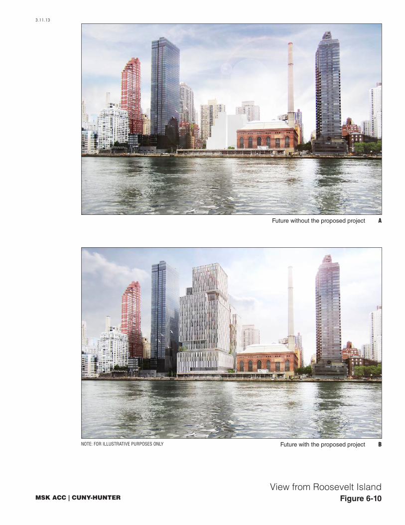
Figure 6-10
3.11.13
View from Roosevelt Island
BFuture with the proposed project
Future without the proposed project A
NOTE: FOR ILLUSTRATIVE PURPOSES ONLY

Figure 6-11
3.11.13
View of the Main Entrance on East 74th Street
BFuture with the proposed project
Future without the proposed project A
NOTE: FOR ILLUSTRATIVE PURPOSES ONLY

Chapter 6: Urban Design and Visual Resources
6-7
proposed on the north façade. There would be a 125-sf sign near the MSK ACC entrance and another 25-sf sign above the entry to the CUNY-Hunter Building. On south end of the east elevation, again above the second floor, there would be another 1,290-sf indirectly illuminated non-flashing sign identifying the MSK ACC. Facing out over the FDR Drive this sign would be visible from the East River and Roosevelt Island (see Figure 1-9). On the west façade near its northern edge, a 500-sf indirectly illuminated non-flashing flashing sign, approximately 100 feet above ground level, would identify the CUNY-Hunter Building along East 74th Street. At ground level there would be a 25-sf illuminated non-flashing façade-mounted sign at the entrance to the CUNY-Hunter Building. At the MSK ACC entrance there would be a freestanding 65-sf indirectly illuminated non-flashing sign (see Figure 1-10). Although the total surface area of the proposed signs would exceed the permitted total surface area, the proposed signage would not have an adverse impact on the pedestrian experience of the project site. The two largest signs face away from the pedestrian paths to the site, which are from the east along East 74th Street, and the third large sign is approximately 100 feet above ground level. On the contrary, the proposed signage would help pedestrians navigate the site and direct them to entrances.
Compared to the future without the proposed project, the proposed project would dramatically alter the urban design character of the project site. The development of two mid-rise buildings on a predominantly vacant site would constitute a visually prominent change in the appearance and character of the project site from the pedestrian perspective. However, this change would not meet the CEQR Technical Manual threshold for a significant adverse urban design impact in that it would not alter the arrangement, appearance, or functionality of the project site such that the alteration would negatively affect a pedestrian’s experience of the area. Rather, instead of a largely vacant and underutilized site, the pedestrian would find new buildings with active ground floors and new street trees and landscaping.
Overall, the proposed project would enhance the pedestrian’s experience and improve the urban design of the project site by replacing vacant land with new, active development on the ground floor. Therefore, the proposed project would not have an adverse impact on urban design on the project site.
VISUAL RESOURCES AND VIEW CORRIDORS
As noted above, there are no visual resources located on the project site. In addition, given that the location of the proposed buildings are consistent with the existing street grid, views toward the East River would still be available from the project site in the future with the proposed project. Therefore, the proposed project would not have adverse impacts on visual resources on the project site.
STUDY AREA
URBAN DESIGN
The proposed project would be constructed on an existing block and would not alter street orientation or street patterns. The proposed project would also be consistent with the height of other structures in the study area, and would be shorter than a number of them, including 1 East River Place at approximately 486 feet tall, The Promenade at approximately 380 feet tall, and 515 East 72nd Street at approximately 415 feet tall (see Figures 6-12). The urban design of the proposed buildings would differ slightly from the immediately adjacent tall, residential towers, in that the mass of the building would be broken down into four- to eight-story zones with setbacks and

3.11.13
Figure 6-12
NOTE
: FOR
ILLU
STRA
TIVE
PUR
POSE
S ON
LY
Context Elevation from the East River
500'-0"
25 STORY BLDG.HEIGHT: 255'-0"
9 STORY BLDG.HEIGHT: 115'-0"
7 STORY BLDG.HEIGHT: 87'-0"
22 STORY BLDG.HEIGHT: 453'-0"
1 STORY BLDG.HEIGHT: 129'-0"
40 STORY BLDG.HEIGHT: 433'-0"
38 STORY BLDG.HEIGHT: 533'-0"
40 STORY BLDG.HEIGHT: 427'-0"
51 STORY BLDG.HEIGHT: 523'-0"
EAST ELEVATION - EAST RIVER
EAST ELEVATION E - EAST RIVER
56TH ST. 57TH ST. 58TH ST. 59TH ST. 60TH ST. 61ST ST. 62ND ST. 63RD ST. 64TH ST. 65TH ST. 66TH ST. 67TH ST. 68TH ST. 69TH ST. 70TH ST. 71ST ST. 72ND ST. 73RD ST. 74TH ST. 75TH ST. 76TH ST. 77TH ST. 78TH ST. 79TH ST.
72ND ST. 73RD ST. 74TH ST. 75TH ST. 76TH ST.
FDR DRIVE
FDR DRIVE
MSK/CUNY-Hunter Project at 74th Street
6-8
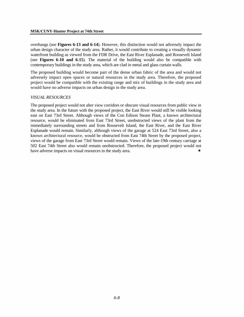
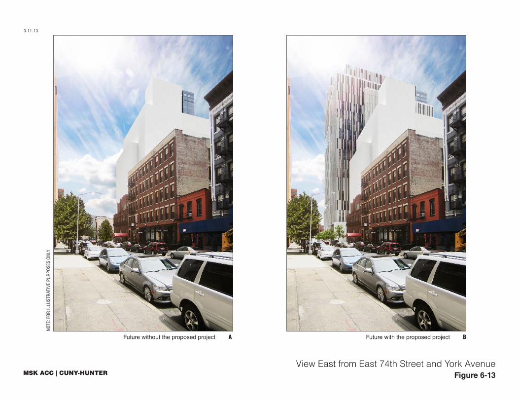
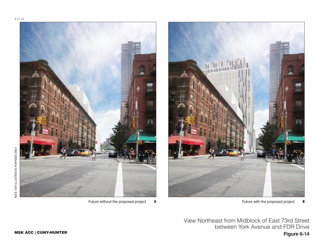
overhangs (see Figures 6-13 and 6-14). However, this distinction would not adversely impact the urban design character of the study area. Rather, it would contribute to creating a visually dynamic waterfront building as viewed from the FDR Drive, the East River Esplanade, and Roosevelt Island (see Figures 6-10 and 6-15). The material of the building would also be compatible with contemporary buildings in the study area, which are clad in metal and glass curtain walls.
The proposed building would become part of the dense urban fabric of the area and would not adversely impact open spaces or natural resources in the study area. Therefore, the proposed project would be compatible with the existing range and mix of buildings in the study area and would have no adverse impacts on urban design in the study area.
VISUAL RESOURCES
The proposed project would not alter view corridors or obscure visual resources from public view in the study area. In the future with the proposed project, the East River would still be visible looking east on East 73rd Street. Although views of the Con Edison Steam Plant, a known architectural resource, would be eliminated from East 73rd Street, unobstructed views of the plant from the immediately surrounding streets and from Roosevelt Island, the East River, and the East River Esplanade would remain. Similarly, although views of the garage at 524 East 73rd Street, also a known architectural resource, would be obstructed from East 74th Street by the proposed project, views of the garage from East 73rd Street would remain. Views of the late-19th century carriage at 502 East 74th Street also would remain unobstructed. Therefore, the proposed project would not have adverse impacts on visual resources in the study area.
3.11.13
Figure 6-13
NOTE
: FOR
ILLU
STRA
TIVE
PUR
POSE
S ON
LY
Future without the proposed project A Future with the proposed project B
View East from East 74th Street and York Avenue
3.11.13
Figure 6-14
NOTE
: FOR
ILLU
STRA
TIVE
PUR
POSE
S ON
LY
Future without the proposed project A Future with the proposed project B
View Northeast from Midblock of East 73rd Streetbetween York Avenue and FDR Drive
Figure 6-15
3.11.13
BFuture with the proposed project
Future without the proposed project A
NOTE: FOR ILLUSTRATIVE PURPOSES ONLY
View Southwest from the East