CHAPTER 8. LAND AND SUBMERGED LAND USE - … 8. LAND AND SUBMERGED LAND USE 8.1 AFFECTED ENVIRONMENT...
22
Guam and CNMI Military Relocation Final EIS (July 2010) VOLUME 3: MARINE CORPS – TINIAN 8-1 Land and Submerged Land Use CHAPTER 8. LAND AND SUBMERGED LAND USE 8.1 AFFECTED ENVIRONMENT 8.1.1 Definition of Resource This chapter describes and analyzes impacts of the proposed action on land and submerged lands ownership and management, and land and submerged lands use. Submerged lands refer to coastal waters extending from the Commonwealth of the Northern Mariana Islands (CNMI) coastline into the ocean 3 nautical miles (nm) (5.6 kilometers [km]), the limit of state or territorial jurisdiction. Land use discussions for this Draft Environmental Impact Statement (EIS) include civilian and military existing and planned land uses, and land use planning guidance that directs future development. With respect to land ownership on Tinian, fee interest ownership is the primary means of private land ownership; leases or easements may also be used for land transfer or management purposes. On Tinian, the Department of Defense (DoD) leases approximately two-thirds of the total island area, exerting a notable influence upon Tinian land use. This chapter is organized to first look at existing conditions then impacts are identified by alternatives and components. The chapter concludes with identification and discussion of proposed mitigation measures that apply to significant impacts. The region of influence (ROI) for land use is land and submerged lands of Tinian. The proposed action is limited to Tinian; therefore, the emphasis is on Tinian with background information provided on CNMI. 8.1.2 Tinian Article XI and XII of the CNMI Constitution states that public lands collectively belong to the people of the Commonwealth who are of Northern Marianas decent. These lands were originally to be managed by the board-governed autonomous government agency known as the Marianas Public Land Authority. In 2006, the governor replaced the Marianas Public Land Authority with the Department of Public Lands (DPL). The DPL is under the executive branch and is the official government agency responsible for the administration and deposition of public lands in the CNMI. These public lands are available for lease for commercial purposes. Land can be privately owned in the CNMI, but only by persons of “Northern Marianas descent,” which is defined as persons who are “of at least one-quarter Northern Marianas Chamorro or Northern Marianas Carolinian” and those persons are further defined as those who were living in the Northern Marianas in 1950. The Northern Mariana Islands became self-governing under the terms of the “Covenant to Establish a CNMI in Political Union with the United States of America (Covenant)” that was negotiated with the United States (U.S.) (U.S. and CNMI 1975a). The Covenant defines the relationship between the Northern Mariana Islands and the U.S., recognizing sovereignty of the U.S., but limiting, in some respects, the applicability of federal law. The Covenant was approved by Northern Mariana Islands voters on June 17 th , 1975, and after approval by the U.S. House of Representatives and the Senate, then President Ford signed Public Law 94-281 enacting the Covenant on March 24, 1976.
Transcript of CHAPTER 8. LAND AND SUBMERGED LAND USE - … 8. LAND AND SUBMERGED LAND USE 8.1 AFFECTED ENVIRONMENT...
Guam and CNMI Military Relocation Final EIS (July 2010)
VOLUME 3: MARINE CORPS – TINIAN 8-1 Land and Submerged Land Use
CHAPTER 8. LAND AND SUBMERGED LAND USE
8.1 AFFECTED ENVIRONMENT
8.1.1 Definition of Resource
This chapter describes and analyzes impacts of the proposed action on land and submerged lands ownership and management, and land and submerged lands use. Submerged lands refer to coastal waters extending from the Commonwealth of the Northern Mariana Islands (CNMI) coastline into the ocean 3 nautical miles (nm) (5.6 kilometers [km]), the limit of state or territorial jurisdiction.
Land use discussions for this Draft Environmental Impact Statement (EIS) include civilian and military existing and planned land uses, and land use planning guidance that directs future development. With respect to land ownership on Tinian, fee interest ownership is the primary means of private land ownership; leases or easements may also be used for land transfer or management purposes. On Tinian, the Department of Defense (DoD) leases approximately two-thirds of the total island area, exerting a notable influence upon Tinian land use.
This chapter is organized to first look at existing conditions then impacts are identified by alternatives and components. The chapter concludes with identification and discussion of proposed mitigation measures that apply to significant impacts.
The region of influence (ROI) for land use is land and submerged lands of Tinian. The proposed action is limited to Tinian; therefore, the emphasis is on Tinian with background information provided on CNMI.
8.1.2 Tinian
Article XI and XII of the CNMI Constitution states that public lands collectively belong to the people of the Commonwealth who are of Northern Marianas decent. These lands were originally to be managed by the board-governed autonomous government agency known as the Marianas Public Land Authority. In 2006, the governor replaced the Marianas Public Land Authority with the Department of Public Lands (DPL). The DPL is under the executive branch and is the official government agency responsible for the administration and deposition of public lands in the CNMI. These public lands are available for lease for commercial purposes.
Land can be privately owned in the CNMI, but only by persons of “Northern Marianas descent,” which is defined as persons who are “of at least one-quarter Northern Marianas Chamorro or Northern Marianas Carolinian” and those persons are further defined as those who were living in the Northern Marianas in 1950.
The Northern Mariana Islands became self-governing under the terms of the “Covenant to Establish a CNMI in Political Union with the United States of America (Covenant)” that was negotiated with the United States (U.S.) (U.S. and CNMI 1975a). The Covenant defines the relationship between the Northern Mariana Islands and the U.S., recognizing sovereignty of the U.S., but limiting, in some respects, the applicability of federal law. The Covenant was approved by Northern Mariana Islands voters on June 17th, 1975, and after approval by the U.S. House of Representatives and the Senate, then President Ford signed Public Law 94-281 enacting the Covenant on March 24, 1976.

Guam and CNMI Military Relocation Final EIS (July 2010)
VOLUME 3: MARINE CORPS – TINIAN 8-2 Land and Submerged Land Use
8.1.2.1 CNMI DoD Land Lease and Management
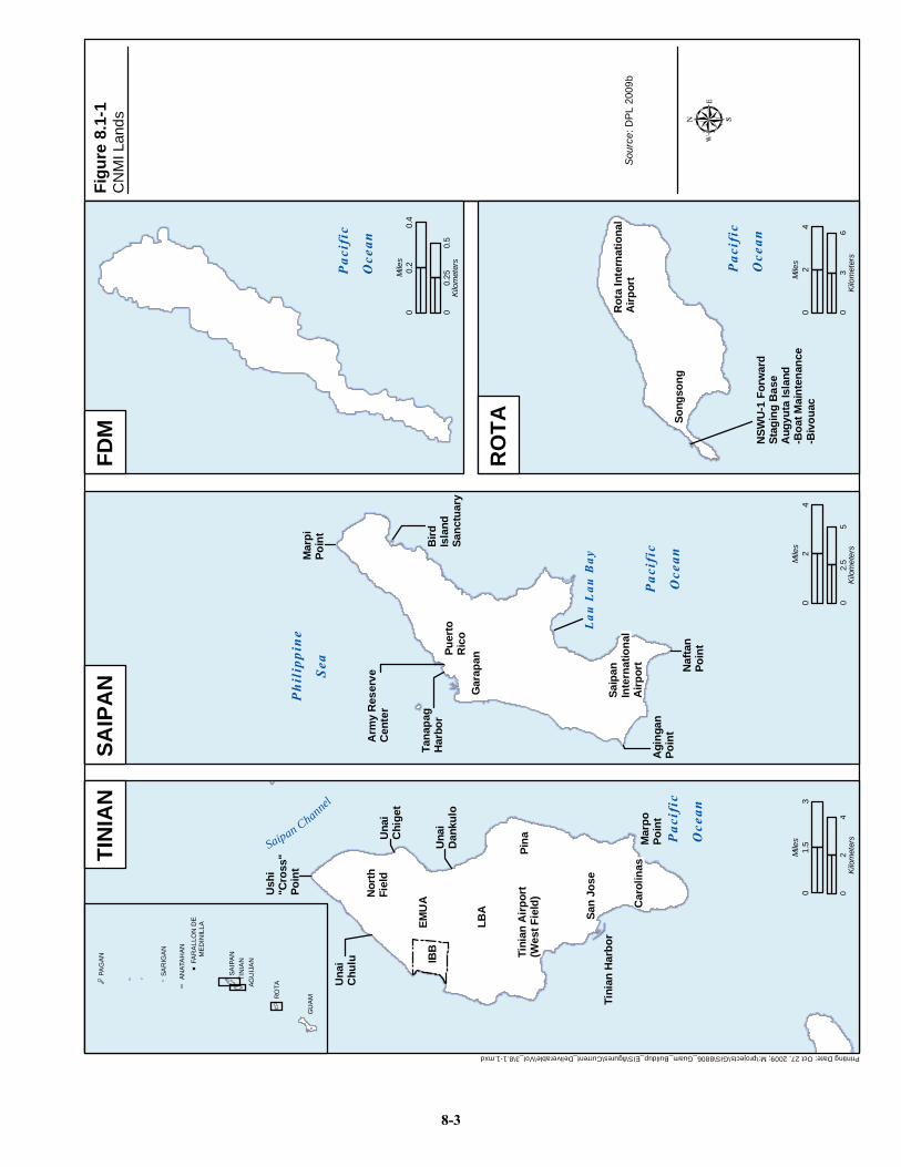
Article VIII of the Covenant (1975a) stated that the following property would be “made available to the U.S. by lease to enable it to carry out its defense responsibilities” (Figure 8.1-1):
• On Tinian, approximately 17,799 acres (ac) (7,203 hectares [ha]) and the waters immediately adjacent thereto
• On Saipan, approximately 177 ac (72 ha) at Tanapag Harbor • On Farallon de Medinilla, approximately 206 ac (83 ha) encompassing the entire island the
waters immediately adjacent thereto
The lease was issued on January 6, 1983 for an initial term of 50 years, and with an option for the U.S. to renew for a succeeding additional 50-year term.
A separate Technical Agreement Regarding Use of Land to Be Leased by the United States in the Northern Mariana Islands (Technical Agreement) was simultaneously executed with the Covenant that provided for the leaseback of property and joint use arrangements for San Jose Harbor and West Field on Tinian (U.S. and CNMI 1975b). The Technical Agreement allowed for leaseback on Tinian for agricultural and grazing type uses for a sum of one dollar per acre per year and leaseback at Tanapag Harbor on Saipan to be used for uses compatible with military use. The Technical Agreement also allowed the leaseback of the remaining leased property on Saipan at no cost for use as a memorial park to honor those who died in the World War II Marianas campaign (Navy Facilities Engineering Command [NAVFAC] Pacific 2008). The remaining portion of the lease area at Tanapag Harbor on Saipan is used for a U.S. Army Reserve Center.
On January 6, 1983, a lease agreement covering the above lands was signed and the Department of the Navy (DoN) assumed control and possession. Any non-military uses within the leased areas must be approved by the DoN (NAVFAC Pacific 2008).
No lands on Rota are included under the lease; however, the CNMI Government allows the DoD uses of certain areas on Rota as well as certain non-lease areas on Tinian, including the commercial harbor, Tinian International Airport, and a staging area near San Jose Village (refer to Table 8.1-1). A right-of-entry agreement was granted for Navy SEAL training on Rota. The area of use is limited to West Harbor in Song Song village and the adjacent Angyuta Island (Commander of the Navy Region [COMNAV] Marianas 2004).
8.1.2.2 CNMI Submerged Lands Ownership and Management
Article XI of the Commonwealth Constitution states that “the submerged lands off the coast of the commonwealth are public lands belonging collectively to the people of the Commonwealth who are of Northern Marianas descent.” The Commonwealth jurisdictional boundaries extend 3 nm (5.6 km) offshore and are managed by the DPL. Although jurisdiction has been disputed in the past, CNMI v. U.S. (2002) concluded that “the U.S. possesses paramount rights in and powers over the waters extending seaward of the ordinary water mark on the Commonwealth coast and the lands, minerals and other things of value underlying the waters…” (DoN 2010).
Printing Date: Oct 27, 2009; M:\projects\GIS\8806_Guam_Buildup_EIS\figures\Current_Deliverable\Vol_3\8.1-1.mxd
CN
MI L
ands
Figu
re 8
.1-1
GU
AMR
OTAAG
UIJ
AN
TIN
IAN
SAIP
AN
FAR
ALL
ON
DE
M
EDIN
ILLA
ANAT
AH
AN
SAR
IGA
N
PAG
AN
Pac
ific
Oce
an
Nor
th
Nor
th
Fiel
dFi
eld
San
Jose
San
Jose
Saipan Channel
EMU
AEM
UA
LBA
LBA
Una
iC
hulu
Tini
an H
arbo
r
Tini
an A
irpor
tTi
nian
Airp
ort
(Wes
t Fie
ld)
(Wes
t Fie
ld)
IBB
IBB
SAIP
AN
SAIP
AN
Phi
lipp
ine
Sea
Saip
an
Saip
an
Inte
rnat
iona
l In
tern
atio
nal
Airp
ort
Airp
ort
Gar
apan
Gar
apan
Arm
y R
eser
veC
ente
r
Pac
ific
Oce
an
TIN
IAN
TIN
IAN
FDM
FDM
RO
TAR
OTA
Mar
piPo
int
Lau
Lau
Bay
Rot
a In
tern
atio
nal
Rot
a In
tern
atio
nal
Airp
ort
Airp
ort
Song
song
Song
song
Pac
ific
Oce
an
Pac
ific
Oce
an
NSW
U-1
For
war
dSt
agin
g B
ase
Aug
yuta
Isla
nd-B
oat M
aint
enan
ce-B
ivou
ac
Naf
tan
Poin
t
Agi
ngan
Poin
t
Puer
toPu
erto
Ric
oR
ico
Bird
Isla
ndSa
nctu
ary
Una
iC
hige
t
Mar
poPo
int
Una
iD
anku
lo
Pina
Pina
Car
olin
asC
arol
inas
Ush
i "C
ross
"Po
int
02
4Ki
lom
eter
s
03
1.5
Mile
s
03
6Ki
lom
eter
s
04
2M
iles
00.
250.
5Ki
lom
eter
s
00.
40.
2M
iles
02.
55
Kilo
met
ers
04
2M
iles
Tana
pag
Har
bor
Sour
ce: D
PL 2
009b
8-3
Guam and CNMI Military Relocation Final EIS (July 2010)
VOLUME 3: MARINE CORPS – TINIAN 8-4 Land and Submerged Land Use
8.1.2.3 CNMI Land Use
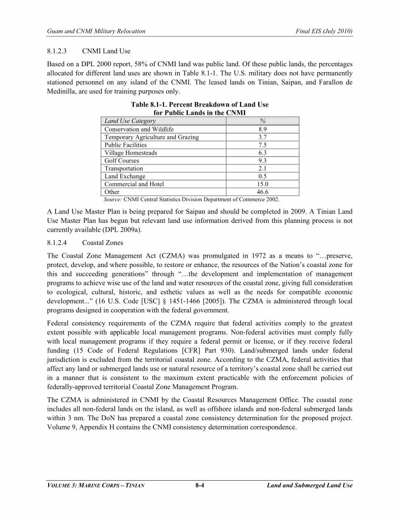
Based on a DPL 2000 report, 58% of CNMI land was public land. Of these public lands, the percentages allocated for different land uses are shown in Table 8.1-1. The U.S. military does not have permanently stationed personnel on any island of the CNMI. The leased lands on Tinian, Saipan, and Farallon de Medinilla, are used for training purposes only.
Table 8.1-1. Percent Breakdown of Land Use for Public Lands in the CNMI
Land Use Category % Conservation and Wildlife 8.9 Temporary Agriculture and Grazing 3.7 Public Facilities 7.5 Village Homesteads 6.3 Golf Courses 9.3 Transportation 2.1 Land Exchange 0.5 Commercial and Hotel 15.0 Other 46.6 Source: CNMI Central Statistics Division Department of Commerce 2002.
A Land Use Master Plan is being prepared for Saipan and should be completed in 2009. A Tinian Land Use Master Plan has begun but relevant land use information derived from this planning process is not currently available (DPL 2009a).
8.1.2.4 Coastal Zones
The Coastal Zone Management Act (CZMA) was promulgated in 1972 as a means to “…preserve, protect, develop, and where possible, to restore or enhance, the resources of the Nation’s coastal zone for this and succeeding generations” through “…the development and implementation of management programs to achieve wise use of the land and water resources of the coastal zone, giving full consideration to ecological, cultural, historic, and esthetic values as well as the needs for compatible economic development...” (16 U.S. Code [USC] § 1451-1466 [2005]). The CZMA is administered through local programs designed in cooperation with the federal government.
Federal consistency requirements of the CZMA require that federal activities comply to the greatest extent possible with applicable local management programs. Non-federal activities must comply fully with local management programs if they require a federal permit or license, or if they receive federal funding (15 Code of Federal Regulations [CFR] Part 930). Land/submerged lands under federal jurisdiction is excluded from the territorial coastal zone. According to the CZMA, federal activities that affect any land or submerged lands use or natural resource of a territory’s coastal zone shall be carried out in a manner that is consistent to the maximum extent practicable with the enforcement policies of federally-approved territorial Coastal Zone Management Program.
The CZMA is administered in CNMI by the Coastal Resources Management Office. The coastal zone includes all non-federal lands on the island, as well as offshore islands and non-federal submerged lands within 3 nm. The DoN has prepared a coastal zone consistency determination for the proposed project. Volume 9, Appendix H contains the CNMI consistency determination correspondence.

Guam and CNMI Military Relocation Final EIS (July 2010)
VOLUME 3: MARINE CORPS – TINIAN 8-5 Land and Submerged Land Use
The CZMA is administered in CNMI by Coastal Resources Management Office. The coastal zone includes all non-federal lands on the island, as well as offshore islands and non-federal submerged lands within 3 nm. The Navy prepared and submitted a coastal zone consistency negative determination for the proposed actions on Tinian to the Coastal Resources Management Office on April 1, 2010 (resubmitted April 27, 2010). Pursuant to 15 CFR Section 930.35(c), the CNMI Coastal Resources Management Office was not obligated to respond to the negative determination, and since the CNMI Coastal Resources Management Office did not respond to the negative determination within 60 days, the CNMI Coastal Resources Management Office concurrence with the negative determination was presumed. Volume 9, Appendix H contains the CNMI negative determination.
The Coastal Resources Management Office has identified Areas of Particular Concern (APC) that are geographic delineated areas with special management requirements. Before work begins on any project to be located wholly or partially within an APC, a valid coastal permit is required. This is not applicable to federal-lease lands or federally-owned submerged lands, but the CZMA consistency determination addresses potential impacts on these APCs. Currently, there are five APCs in CNMI:
1. Shoreline – The area between the mean high water mark and 150 feet (ft) (46 meters [m]) inland
2. Lagoon and Reef – The area extending seaward from the mean high water mark to the outer slope of the reef
3. Wetlands and Mangrove – Those areas that are permanently or periodically covered with water and where species of wetland or mangrove vegetation can be found
4. Port and Industrial – Those land and water areas surrounding the commercial ports of Saipan, Tinian, and Rota
5. Coastal Hazards – Those areas identified as coastal flood hazard zones in the Federal Emergency Management Agency Flood Insurance Rate Maps
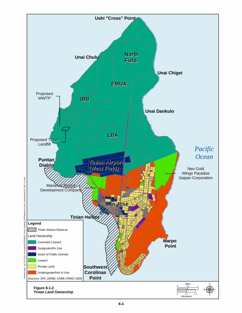
8.1.2.5 Tinian Land and Submerged Lands Ownership
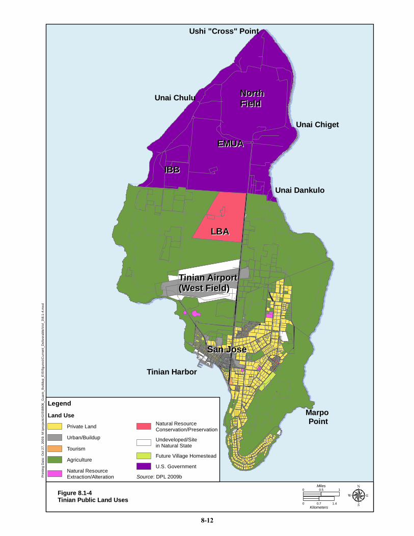
Tinian land area is approximately 25,151 ac (10,180 ha) in size. Tinian has approximately 68 miles (mi) (110 km) of roads, administered by CNMI’s Department of Public Works. Eighth Avenue and Broadway are the key north-south roadways (Figure 8.1-2). Ten percent (approximately 2,422 ac [980 ha]) is privately owned and the remainder (22,726 ac [9,200 ha]) is public land (DPL 2009b). Public land is further classified and is listed in Table 8.1-2 and shown in Figure 8.1-2.
Table 8.1-2. Tinian Land Ownership Owner Acres
(% Total land) Public Land
Sub-classification Public Land Acreage
(% Total land) Private 2,422 (10%) NA NA Public Land 22,729 (90%) Grant of Public Domain 1,569 (7%) Total 25,151 (100%) Designated/In use 662 (3%) Leased 1,638 (7%) Covenant Leased 15,469 (68%) Undesignated/Not in Use 3,388 (15%) Total 22,726 (100%) Legend: NA = Not Applicable. Source: DPL 2009a.
NorthNorthFieldField
Tinian AirportTinian Airport(West Field)(West Field)
IBBIBB
EMUAEMUA
LBALBA
San JoseSan Jose
PacificOcean
Ushi "Cross" Point
Unai Chulu
Unai Chiget
Unai Dankulo
Marpo Point
Tinian Harbor
Marianas ResortMarianas ResortDevelopment CompanyDevelopment Company
Proposed TinianProposed TinianLandfillLandfill
ProposedProposedWWTPWWTP
Neo GoldNeo GoldWings ParadiseWings Paradise
Saipan CorporationSaipan Corporation
PuntanDiablo
SouthwestCorolinas
PointPrin
ting
Dat
e: J
an 2
9, 2
010,
M:\p
roje
cts\
GIS
\880
6_G
uam
_Bui
ldup
_EIS
\figu
res\
Cur
rent
_Del
iver
able
\Vol
_3\8
.1-2
.mxd
Figure 8.1-2Tinian Land Ownership
0 0.7 1.4Kilometers
0 10.5Miles
µ
Land Ownership
Sources: DPL 2009b; CNMI CRMO 2009
Legend
Undesignate/Not In Use
Private Land
Leased
Grant of Public Domain
Designated/In Use
Covenant Leased
Tinian Marine Reserve
8-6
Guam and CNMI Military Relocation Final EIS (July 2010)
VOLUME 3: MARINE CORPS – TINIAN 8-7 Land and Submerged Land Use
Grant of Public Domain public lands are given in fee simple, and no specific use is specified. Designated public lands are actively managed for a particular use such as a forest or park. Leased land use requires government approval. If the area is greater than 12.4 ac (5 ha), then it must be approved by CNMI legislature. Areas less than 12.4 ac (5 ha) require DPL approval. These permits tend to be for commercial operations, such as hotels, golf courses, and cattle grazing. There are two approved permits as shown in Figure 8.1-2. Neo Gold Wings Paradise Saipan Corporation leases 741 ac (300 ha) for development of a casino, hotel, conference hall and amusement park (16th Northern Marianas Commonwealth Legislature 2009). Marianas Resort Development Company holds a lease for 337 ac (136 ha) for development of a golf course, casino, hotel and guest cottages (15th Northern Marianas Commonwealth Legislature 2007).
Tinian public lands without a specified use are undeveloped and are classified as undesignated public lands. DPL is required to make available some portion of public lands for a homestead program. A person is not eligible for more than one agricultural and one village homestead. A freehold interest in the homestead is granted once the person meets specified criteria and cannot be transferred for 10 years after receipt (15th Northern Marianas Commonwealth Legislature 2007). A future village homestead has been designated northwest of San Jose.
Covenant lands are leased to the military for training and are collectively referred to as the Military Lease Area (MLA). The MLA encompasses the northern estimated two-thirds of the island, and it is divided into the Exclusive Military Use Area (EMUA) and the Leaseback Area (LBA) (Figure 8.1-3). The MLA is largely undeveloped. There are no fences or gates to control access to the MLA. Specific areas within the MLA are fenced, such as an unexploded ordnance (UXO) area and a communications facility. There are remnant roadways, structures, airfields and runways from historical military use that are used for access and military training. Broadway and 8th Avenue are the primary Tinian north-south access roads that extend through the MLA.
All private land and non-covenant leased lands are located south of the MLA (refer to Figure 8.1-2). The submerged lands extend to 3 nm (5.6 km) from the coast of Tinian and other CNMI islands. The U.S. acquired rights to submerged lands of the CNMI pursuant to Article I, § 101 of The Covenant to Establish a Commonwealth of the Northern Mariana Islands (U.S. and CNMI 1975a). The jurisdiction over submerged lands has been disputed in the past, but in CNMI v. U.S. (2002) it was concluded that “The United States possesses paramount rights in and powers over the waters extending seaward of the ordinary water mark on the Commonwealth coast and the lands, minerals and other things of value underlying the waters…”
8.1.2.6 Tinian Areas of Particular Concern
The CRM office has identified three APCs for Tinian. These consist of shoreline, wetlands, port, and industrial APCs (Figure 8.1-3). The shoreline APC includes the entire island to the high water mark and is not depicted on Figure 8.1-3. The shoreline APC encompasses the entire island to the mean high water mark on the coastline. The Lake Hagoi portion of the wetland APC and most of the shoreline APC lies within the MLA. Before work begins on any project to be located wholly or partially within an APC, a valid coastal permit is required. This is not applicable to federal lease lands or federally owned submerged lands, but the CZMA consistency determination addresses potential impacts on these APCs. The Coastal Zone Consistency Determination Assessment and correspondence is included in the EIS appendices.
_̂
_̂
_̂
_̂
_̂_̂
_̂
_̂
_̂
_̂
NorthNorthFieldField
Tinian AirportTinian Airport(West Field)(West Field)
IBBIBB
EMUAEMUA
LBALBA
San JoseSan Jose
Ushi "Cross" Point
Unai Chiget
Unai Dankulo
Marpo Point
Tinian Harbor
Hagoi
MLAMLAMLAMLA
Unai Chulu
Unai Masalok
Kammer Beach
BivouacsBivouacsUnai Lam Lam
Leprosarium BeachForward Staging Base
Training inUrban Environment
Tinian Harbor LogisticSupport Operations
-Airfield Seizure/Defense-Forward Area Refueling
Military Training WastewaterTreatment Disposal System
Automobile Landingsand Logistics Support
-Helicopter Insertionsand Extractions-Paradrops
-Airmobile Landings-C-130 Cargo Drops-Night Vision Training
Prin
ting
Dat
e: M
ar 1
, 201
0, M
:\pro
ject
s\G
IS\8
806_
Gua
m_B
uild
up_E
IS\fi
gure
s\C
urre
nt_D
eliv
erab
le\V
ol_3
\8.1
-3.m
xd
Figure 8.1-3Tinian Military Land Use
0 0.7 1.4Kilometers
0 10.5Miles
µ
8 th
Ave
Bro
adw
ay
EMV
and
CAD
HER
O U
nsaf
e
Note: Shoreline APC includes entireisland to mean high water mark.Source: DPL 2009b
LegendProposed Agriculture &Conservation Park
Pyrotechnics and FiresPermitted on Pavement
EMR Zone
Port & Industrial APC
Wetland APC
Military Use Landing Site
Planning Considerations
FAA Mitigation Area
Military Lease Area (MLA)
Utility Craft_̂
Combat Rubber Craft_̂
Air Craft Cushion_̂
No Military Training
No Wildlife Disturbance
Restricted Military Training
8-8
Guam and CNMI Military Relocation Final EIS (July 2010)
VOLUME 3: MARINE CORPS – TINIAN 8-9 Land and Submerged Land Use
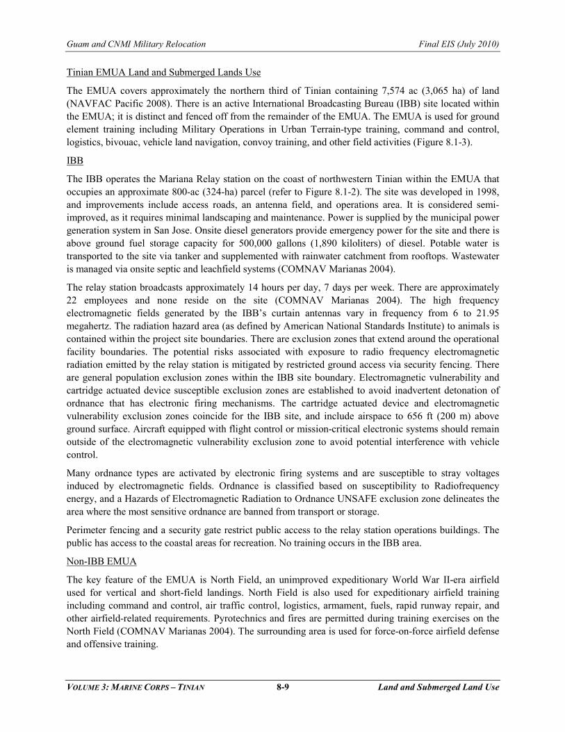
Tinian EMUA Land and Submerged Lands Use
The EMUA covers approximately the northern third of Tinian containing 7,574 ac (3,065 ha) of land (NAVFAC Pacific 2008). There is an active International Broadcasting Bureau (IBB) site located within the EMUA; it is distinct and fenced off from the remainder of the EMUA. The EMUA is used for ground element training including Military Operations in Urban Terrain-type training, command and control, logistics, bivouac, vehicle land navigation, convoy training, and other field activities (Figure 8.1-3).
IBB
The IBB operates the Mariana Relay station on the coast of northwestern Tinian within the EMUA that occupies an approximate 800-ac (324-ha) parcel (refer to Figure 8.1-2). The site was developed in 1998, and improvements include access roads, an antenna field, and operations area. It is considered semi- improved, as it requires minimal landscaping and maintenance. Power is supplied by the municipal power generation system in San Jose. Onsite diesel generators provide emergency power for the site and there is above ground fuel storage capacity for 500,000 gallons (1,890 kiloliters) of diesel. Potable water is transported to the site via tanker and supplemented with rainwater catchment from rooftops. Wastewater is managed via onsite septic and leachfield systems (COMNAV Marianas 2004).
The relay station broadcasts approximately 14 hours per day, 7 days per week. There are approximately 22 employees and none reside on the site (COMNAV Marianas 2004). The high frequency electromagnetic fields generated by the IBB’s curtain antennas vary in frequency from 6 to 21.95 megahertz. The radiation hazard area (as defined by American National Standards Institute) to animals is contained within the project site boundaries. There are exclusion zones that extend around the operational facility boundaries. The potential risks associated with exposure to radio frequency electromagnetic radiation emitted by the relay station is mitigated by restricted ground access via security fencing. There are general population exclusion zones within the IBB site boundary. Electromagnetic vulnerability and cartridge actuated device susceptible exclusion zones are established to avoid inadvertent detonation of ordnance that has electronic firing mechanisms. The cartridge actuated device and electromagnetic vulnerability exclusion zones coincide for the IBB site, and include airspace to 656 ft (200 m) above ground surface. Aircraft equipped with flight control or mission-critical electronic systems should remain outside of the electromagnetic vulnerability exclusion zone to avoid potential interference with vehicle control.
Many ordnance types are activated by electronic firing systems and are susceptible to stray voltages induced by electromagnetic fields. Ordnance is classified based on susceptibility to Radiofrequency energy, and a Hazards of Electromagnetic Radiation to Ordnance UNSAFE exclusion zone delineates the area where the most sensitive ordnance are banned from transport or storage.
Perimeter fencing and a security gate restrict public access to the relay station operations buildings. The public has access to the coastal areas for recreation. No training occurs in the IBB area.
Non-IBB EMUA
The key feature of the EMUA is North Field, an unimproved expeditionary World War II-era airfield used for vertical and short-field landings. North Field is also used for expeditionary airfield training including command and control, air traffic control, logistics, armament, fuels, rapid runway repair, and other airfield-related requirements. Pyrotechnics and fires are permitted during training exercises on the North Field (COMNAV Marianas 2004). The surrounding area is used for force-on-force airfield defense and offensive training.

Guam and CNMI Military Relocation Final EIS (July 2010)
VOLUME 3: MARINE CORPS – TINIAN 8-10 Land and Submerged Land Use
The frequency of training activities planned on Tinian is described in the Mariana Islands Range Complex (MIRC) EIS/Overseas EIS (OEIS) (DoN 2010). The MIRC training frequency is the baseline for the “no-action alternative” training tempo. The baseline establishes a maximum frequency per year for a type of training that can occur within the MIRC.
Four major military exercises could occur per year on Tinian, including joint forces training. Night vision training exercises at North Field range from 30 to 75 sorties per year. Night vision ground training (Intelligence Surveillance and Reconnaissance) is estimated to occur on Tinian twice per year. Approximately four “seize airfield” events and airfield expeditionary events could occur per year. There are five annual Amphibious Assault Marine Air Ground Task Force training events. Military Operations in Urban Terrain (MOUT) training is estimated at one event per year.
There are no active live-fire ranges on the EMUA. There have been clandestine reconnaissance and hostage rescue exercises at the Japanese Air Command Post at North Field where controlled live-fire was used. The sniper small arms were shot into bullet traps inside the building. The EMUA has been used for large (e.g., 2,000 troops) Marine Expeditionary Unit training events. The area is mostly forested, providing a realistic combat environment for jungle-like maneuvers and amphibious landings (DoN 2010).
The EMUA has two sandy beaches, Unai Chulu and Unai Dankulo (Long Beach). Only Unai Chulu has been used for Landing Craft Air Cushion training; however, storm damage and tree growth requires craft landing zone and beach improvements prior to use. Hydrographic surveys are conducted from small boats in the submerged lands around Tinian. Non-combatant evacuation operations occur at Unai Chulu and Tinian Harbor and North Field (DoN 2010).
There are five areas where training is not allowed in the EMUA. One exclusion area is a former small arms range located on the east coast. This former range is an UXO (60 millimeter [mm] and 40 mm) contaminated area near Unai Chiget within the EMUA that should not be accessed except by trained UXO personnel. The area is secured by fencing and warning signs are posted. Lake Hagoi, Unai Chulu, Unai Lam Lam and Unai Dankulo (Long Beach) have training restrictions in designated areas because of cultural or natural resources. There is a no wildlife disturbance area that is located in the EMUA and the LBA.
There are 13 points of interest within the EMUA that are on the self-guided Tinian Historic Interpretive Trail. No parks or recreation areas are designated in the EMUA. Refer to the recreation section for land and submerged lands uses off of the EMUA coastline. No agricultural uses are permitted within the EMUA, but historically there have been reports of animals grazing (COMNAV Marianas 2004).
Public access to the EMUA could be restricted an estimated eight weeks per year, for the four two-week major training events per year, based on the MIRC range training plan. In recent history, the entire EMUA has been closed to the public for Tandem Thrust exercises (Joint U.S. and Australian forces) that occurred in March 15-April 4 1999 and April 14, to May 5, 2003. Portions of the EMUA have been restricted for Millennium Edge, a few cargo drop exercises, TriCab and the 1996 Operation Pacific Heaven (DoD Public Military Affairs 2009).
LBA and Tinian Agriculture
The Tinian LBA is approximately 7,779 ac (3,148 ha) and located in the middle third of the island. The CNMI government issues permits for LBA lands to Tinian residents for grazing and agricultural uses. LBA is used for ground element training including MOUT-type training, command and control, logistics, bivouac, vehicle land navigation, convoy training, and other field activities. There are no active live-fire

Guam and CNMI Military Relocation Final EIS (July 2010)
VOLUME 3: MARINE CORPS – TINIAN 8-11 Land and Submerged Land Use
ranges in the LBA. Exercise maneuver training is permitted in the LBA. The U.S. may train in the LBA, subject to written notification of CNMI, and has agreed to minimize impact to the Tinian Airport. The frequency of training is tied to that described for the EMUA. There is one limited training area on the east coast near Unai Masalok, restricted to small unit insertion training. There is a Federal Aviation Administration (FAA) wildlife mitigation area and a no wildlife disturbance area in the LBA. The conservation area is commonly referred to as the FAA Mitigation Area.
There are seven points of interest within the LBA that are on the Tinian self-guided tour; however, public access is restricted during training. Refer to the recreation section for other land and submerged lands uses in the LBA.
Land uses adjacent to the LBA include the Tinian Airport, the three lease areas, undesignated lands and private land parcels.
The LBA can be used for agricultural grazing or other uses. The CNMI government consults with the U.S. government on agreed compatible uses. The leaseback area is generally subject to the following conditions under the leaseback agreement terms (U.S. and CNMI 1975b):
• Initial term of lease is 10 years and is potentially renewable in 10 year increments. • The uses located in the vicinity of the Tinian Airport must be consistent with FAA safety
requirements. • Uses must be compatible with planned military use. • No permanent construction without prior consent. • The leaseback agreement is subject to cancellation upon one year’s notice or sooner in the
event of a national emergency. • Provisions for fair compensation exist in the event of cancellation or early termination.
There are 35 lessees, leasing 48 parcels in the LBA for a total agriculture/grazing permit area estimated at 2,552 ac (1,032 ha) (Figure 8.1-4). The largest parcel is 563 ac (228 ha) and all others are less than 124 ac (50 ha) (DPL 2009b). Individual pastures may be fenced. Total agricultural land use for the entire island of Tinian is estimated at 11,956 ac (4,838 ha).
The USDA identifies prime farmland soils that have properties that are suitable for economic production of sustained high yields of crops. Three prime farmland soils classes were identified on Tinian in the Soil Survey of the Islands of Aguijan, Rota, Saipan, and Tinian, Commonwealth of the Northern Mariana Islands (Young 1989), as follows:
• Dandan-Saipan clays, 0-5% slope • Kagman clay, 0-5% slopes • Saipan clay, 0-5% slopes
Dandan-Saipan clays 0-5% and Saipan clay, 0-5% were identified within and adjacent to the LBA as shown on Figure 8.2-1 located in the Environmental Consequences Section 8.2. The Kagman clay 0-5% prime farmland soils are located outside the MLA in the southern area of Tinian. A map of CNMI designated important or unique farmlands was not available for review. Although they may not have met the specific USDA soil criteria for prime farmland, 46% of the farmland in CNMI is located on Tinian and is concentrated in the southern area of Tinian (Carolinas Plateau) and in the MLA between Tinian International Airport and North Field. Crops (e.g., watermelons, cucumbers) are exported to Saipan and Guam (COMNAV Marianas 2004).
NorthNorthFieldField
Tinian AirportTinian Airport(West Field)(West Field)
IBBIBB
EMUAEMUA
LBALBA
San JoseSan Jose
Ushi "Cross" Point
Unai Chulu
Unai Chiget
Unai Dankulo
Marpo Point
Tinian Harbor
Figure 8.1-4Tinian Public Land Uses
0 0.7 1.4Kilometers
0 10.5Miles
Prin
ting
Dat
e: O
ct 2
7, 2
009,
M:\p
roje
cts\
GIS
\880
6_G
uam
_Bui
ldup
_EIS
\figu
res\
Cur
rent
_Del
iver
able
\Vol
_3\8
.1-4
.mxd
Source: DPL 2009b
Legend
Land Use
Private Land
Urban/Buildup
Tourism
AgricultureFuture Village Homestead
Natural ResourceConservation/Preservation
Natural ResourceExtraction/Alteration
Undeveloped/Sitein Natural State
U.S. Government
8-12

Guam and CNMI Military Relocation Final EIS (July 2010)
VOLUME 3: MARINE CORPS – TINIAN 8-13 Land and Submerged Land Use
U.S. Department of Agriculture (USDA), in cooperation with local agencies, proposed to develop a Tinian Agricultural and Conservation Park within the LBA located adjacent and west of the FAA Mitigation Area. The 176.2-ac (71.5 ha) parcel would provide 148-ac (60 ha) of cropland that would be subdivided into sixty 2.47-ac (1 ha) farm plots. The park would promote joint marketing of agricultural products, facilitate information sharing among farmers, increase the supply of local fresh fruits and vegetables, and promote sound water and soil conservation practices (COMNAV Marianas 2004). The project was never initiated.
8.1.2.7 Military Use Outside of the MLA
A separate Technical Agreement was simultaneously executed with the Covenant that provided for the leaseback of property and joint use arrangements for San Jose Harbor and West Field on Tinian Island. Under the previously referenced Technical Agreement (U.S. and CNMI 1975b) the arrangements for military joint use of San Jose Harbor and West Field on Tinian include the following rights:
• Moor vessels, handle cargo, stage equipment and conduct other port related activities. • Install, operate and maintain fuel and utility lines from the harbor to the MLA landing rights and
development and operating rights for support facilities at the airport. • Use the harbor and airport as ports of entry for troops, vehicles and equipment. There is a staging
area near San Jose used for logistical support associated with major training events.
The Tinian government allows special operations teams using combat rubber craft at Leprosarium and Kammer Beach for nigh-time training landings. Kammer Beach is near the Tinian Dynasty Hotel and residential areas. Only the beach and nearby abandoned structures are used (DoN 2010).
8.2 ENVIRONMENTAL CONSEQUENCES
8.2.1 Approach to Analysis
8.2.1.1 Methodology
Potential direct, short-term land use impacts would be related to facility construction activities; these activities would be located within the project footprint or on previously disturbed lands. In addition, the construction staging and equipment area would be located on DoD land. There would be no land/submerged lands acquisition, nor would pockets of land or public access restrictions would be generated. The land use and land ownership impacts could be discussed under construction or operation. Since the impacts would be long term, the changes in land use and ownership are described under operation and the construction phase impacts are described as not applicable.
The potential indirect impacts that are due to changes in land ownership and use are addressed under other specific resource categories such as traffic, noise, natural resources and recreation. Incompatibility with adjacent land uses to the extent that public health and safety may be impacted is addressed under public health and safety, and noise resource sections. Federal lands are not subject to local zoning regulations and permitting; however, consistency with surrounding non-federal land uses is an important consideration for land use planning. A CZMA consistency determination was prepared by the Marine Corps for all Tinian proposed actions and the correspondence is included in Volume 9, Appendix H.
Land Ownership/Management
Land ownership and management includes lease and right-of-way interests. The impact assessment for land and submerged lands ownership and management is not based on regulatory authority or permit
Guam and CNMI Military Relocation Final EIS (July 2010)
VOLUME 3: MARINE CORPS – TINIAN 8-14 Land and Submerged Land Use
requirements. No change in land or submerged lands ownership is proposed on Tinian. But the existing agriculture/grazing permits in the LBA would be affected, thus impacting land use.
There are no indirect impacts associated with changes in land ownership, except for those that would be discussed under the aforementioned other resource categories. For example, changes in land ownership may impact potential CNMI tax revenues.
Land Use
Two criteria are applied for assessing impacts on land/water use:
1. Consistency with current or documented planned land/water use
2. Restrictions on access due to changes in land use on federally-controlled lands
Land Use Criterion 1: Consistency with Current or Documented Planned Land Use
Tinian land use plan Geographic Information Systems graphics are being prepared for DPL, and the February 2009 versions are presented in this analysis, with permission from DPL. These are draft mapping products and the accompanying land use plan is being developed. Potential adverse land use impacts would result from a proposed land use that is inconsistent with the existing land use or the development of vacant land and open space. Potential adverse impacts would also result if there are incompatible changes in use within submerged lands. The test for significance is the degree of incompatibility and is qualitative.
Land use changes on existing DoD land could be the basis for significant adverse impacts to other resource categories (such as aesthetics, noise, traffic, recreation, cultural and natural resources) within and beyond DoD land boundaries. Impacts to these resources and others are addressed elsewhere in this EIS.
Land Use Criterion 2: Restrictions on Access
Additional restrictions on public access would be a potential adverse impact. The test for significance is subjective and based on the geographic area affected, the schedule or timing of the access restrictions (permanent or occasional), and the population affected.
Farmland Protection Policy Act
The DoD is attempting to minimize effects to agricultural land use. The Farmland Protection Policy Act (FPPA) (Public Law 97-98, 7 USC 4201 and 7 CFR 658) is intended for federal agencies to: 1) identify and take into account the potential adverse effects of federal programs on the preservation of farmland land; and 2) consider alternative actions, as appropriate, that could lessen such adverse effects; and assure that such federal programs, to the extent practicable, are compatible with state, unit of local government, and private programs and policies to protect farmland. The FPPA addresses prime and important farmlands. Consistency with FPPA was a land use significance criterion in the Draft EIS, but was removed for the Final EIS. In the interval between the Draft EIS and the Final EIS, the DoN determined that the Guam and CNMI Military Relocation is exempt from FPPA regulations because the action is undertaken by a federal agency for national defense purposes (section 1547(b) of the Act, 7 U.S.C. 4208(b). However, consistency with FPPA is not a criterion for analysis, impacts to agricultural use are assessed in this EIS in conjunction with impacts to other land uses, such as residential or urban.
8.2.1.2 Issues Identified During Public Scoping Process
Many of the scoping issues regarding land use overlap with other resource areas such as noise and recreation and are discussed under those other resource sections. Comments on land use did not
Guam and CNMI Military Relocation Final EIS (July 2010)
VOLUME 3: MARINE CORPS – TINIAN 8-15 Land and Submerged Land Use
necessarily identify Guam or Tinian as the area of concern. The following are public, including regulatory agency, preferences:
• No increases in federal land ownership (unclear but assumed that comments meant to also apply to military use of the LBA agricultural/grazing permits)
• Current public rights-of-way be retained • Balance between economic benefits and access to the northern part of Tinian
8.2.2 Alternative 1 (Preferred Alternative)
8.2.2.1 Tinian
Construction
The land use and land ownership impacts could be discussed under construction or operation. Since the impacts would be long-term, the changes in land use and ownership are described under operation.
Operation
North
The four proposed ranges would be constructed in the LBA in the north or northeast direction. The Surface Danger Zones (SDZs) generated by the ranges would extend into the EMUA, but would not impact submerged lands. No additional land or submerged lands would be acquired. Existing leases within the LBA would be reviewed and those located within the range footprints or SDZs would be terminated. This represents a potential adverse impact to the lessee and private sub-lessees. The impact is considered less than significant from a land ownership perspective because the leaseback term options are of relatively short duration and may be reviewed by DoD in the event of a military requirement for the land. In addition, the lease terminations would not change land use designations. Other impacts such as the loss of agricultural income are addressed in Chapter 16, Socioeconomics.
Noise from airfield operations and firing range activities would generate increased noise levels within the military area, but not impacting surrounding land use. Some of these activities would occur at night. As shown in Chapter 2 (refer to Table 2.3-1), approximately 20% of munitions used for firing range training would be expended during non-daylight hours (from 7 p.m. to 6 a.m.). The results of the modeling of the noise impacts from Range Complex Alternative 1 are presented in Chapter 6, Noise. The contours would be entirely within the DoD-controlled land except for a small portion extending on the northern edge of the Tinian Airport property. In this case, no noise-sensitive receptors would be impacted, resulting in no noise impacts associated with this alternative.
Portions of the range area would not be accessible by non-participating personnel during training. Training periods would be scheduled in advance with signs posted and published on a regular basis. To facilitate range safety, ground access would be controlled by traffic control points on existing roads. This would safeguard the public by keeping them out of any areas where there are potential dangers while simultaneously maintaining access to areas where training is not being conducted. This would ensure access to National Historic Landmark, northern beaches, and the IBB via 8th Avenue. Broadway would be closed during training. However, the public would be able to travel north on 8th Avenue and check in with personnel manning the first traffic control point. Once cleared by range control, they would proceed, checking in with each successive traffic control point until clear of the training area. Prior to training, range flags would be raised and traffic control points would be established and manned continuously throughout the duration of training. Interior portions of the range area (those affected by SDZs) would be inspected and watches would be posted in a range observation site for boats and aircraft, with positive
Guam and CNMI Military Relocation Final EIS (July 2010)
VOLUME 3: MARINE CORPS – TINIAN 8-16 Land and Submerged Land Use
observation of the sea and air space and having positive communications with range control. The impact is not considered significant. The impact on access would be adverse but less than significant because the military is exercising an existing right based on existing policy. The encroachment of the SDZ into a no-training area is an adverse impact; however, the impact would not be significant because no physical training or construction would occur in the area.
During non-firing periods, the MLA would remain open to other approved civilian uses in accordance with the RTA Management Plan, as discussed in Chapter 2.
In the interval between the Draft EIS and the Final EIS, the DoD attempted to minimize the potential acreage of agricultural leases affected by the proposed action. Based on data obtained in March of 2009, there were 35 agricultural/grazing permits, with lease area totaling approximately 2,552 ac (1,032 ha) in the LBA as shown on Figure 8.2-1. The number of leases may have changed over time and the discussion on impacts is based on 2009 data. It is currently estimated that only approximately 134 ac (55 ha) of the current total agricultural lease area would require termination due to these areas being located within the proposed Alternative 1 range footprints and associated SDZs. This acreage is about 5% of the total amount of agricultural/grazing land available in the LBA. The prime farmland soils within the Alternative 1 range footprints are shown on Figure 8.2-1. According to the data obtained in March of 2009, none of the agricultural lease areas subject to termination are located on prime farmland soils (Figure 8.2-1). Prime farmland soils within the LBA that are located outside of the Alternative 1 range footprints and associated SDZs would continue to be available for agricultural use. There is history of grazing and crop production in the LBA; therefore, the land is suitable for farmland although it may not have designated prime farmland soils. Alternative 1 would result in significant impacts to agricultural use. Associated socioeconomic impacts on agricultural use are discussed in Volume 3, Chapter 16.
There would be a minor loss of open space associated with the range support activities and the ranges that would be situated on vacant lands. No support facilities would be constructed. The SDZs would remain open space except for some access roads for fire protection.
The current policy of restricting public access for an estimated eight weeks to portions of the EMUA being utilized during training would continue under the proposed action. It is estimated that civilian use and access to and through the proposed live-fire ranges would be affected approximately 12 to 16 weeks per year. Traffic control points would be established on primary roadways and manned throughout the duration of training. Security sweeps would be done through the area prior to training. Training would be scheduled and advance notification would be provided to the public. There is no UXO concern that would further restrict access to the SDZs when there is no training. Broadway would be closed during training but access to the National Historic Landmark, northern beaches, and the IBB would continue to be maintained via 8th Avenue. The impact on access would be adverse but less than significant because the military would be exercising an existing right based on existing policy. Access restrictions would have potential impacts on recreation and other resources, as described under other resource sections.
The training ranges are consistent with the intended use of the MLA. No impact to IBB is anticipated and its personnel would be allowed to access the facility. FAA mitigation area and the no wildlife disturbance area would be encumbered by the SDZs and associated impacts are described under the natural resources section.
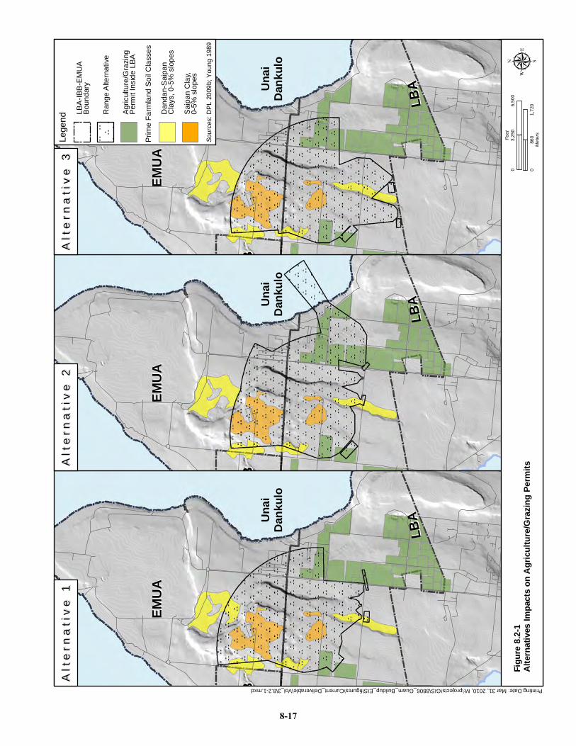
Printing Date: Mar 31, 2010, M:\projects\GIS\8806_Guam_Buildup_EIS\figures\Current_Deliverable\Vol_3\8.2-1.mxd
IBB
IBB
Unai
Dank
ulo
EMUA
EMUA
LBA
LBA
IBB
IBB
Unai
Dank
ulo
EMUA
EMUA
LBA
LBA
IBB
IBB
Unai
Dank
ulo
EMUA
EMUA
LBA
LBA
Sourc
es: D
PL 2
009b
; You
ng 1
989
Lege
nd
LBA
-IBB
-EM
UA
Bou
ndar
y
Agr
icul
ture
/Gra
zing
Per
mit
Insi
de L
BA
Prim
e Fa
rmla
nd S
oil C
lass
es
Sai
pan
Cla
y,0-
5% s
lope
s
Dan
dan-
Sai
pan
Cla
ys, 0
-5%
slo
pes
Ran
ge A
ltern
ativ
e
Figur
e 8.2-
1Al
terna
tives
Impa
cts on
Agr
icultu
re/Gr
azing
Perm
itsµ
086
01,
720
Meter
s
03,
250
6,50
0Fe
et
Alt
ern
ati
ve
1A
lte
rna
tiv
e 1
Alt
ern
ati
ve
2A
lte
rna
tiv
e 2
Alt
ern
ati
ve
3A
lte
rna
tiv
e 3
8-17
Guam and CNMI Military Relocation Final EIS (July 2010)
VOLUME 3: MARINE CORPS – TINIAN 8-18 Land and Submerged Land Use
South
No facilities are proposed in the South, outside of the MLA. Tinian Airport and Harbor would continue to be used to transport personnel, equipment and supplies. There would be no impact to land or submerged lands ownership.
The southernmost proposed facility in the MLA is the rifle “known distance” (KD) 5.56-mm range and it would be adjacent to the Tinian Airport runways. Range support activities (e.g., bivouac activities) could occur adjacent to 8th Avenue and north of the airport runway. As industrial facilities, the airport, firing ranges, and firing range support activities would be consistent land uses. No impact on airport operation is anticipated. The other proposed range facilities are sufficiently north of the MLA boundary as to have no anticipated impact on land uses outside of the MLA.
No impact on agricultural lands is anticipated in the southern area. Use of port and airport facilities would increase but would be consistent with their existing land use. No restrictions on public access are proposed in the south.
8.2.2.2 Summary of Alternative 1 Impacts
Table 8.2-1 is a summary of land use impacts under Alternative 1 by geographic area.
Table 8.2-1. Summary of Alternative 1 Impacts Area Project
Activities Project Specific Impacts
Tinian
Construction Not Applicable
Operation
Permits within the LBA located in the range footprints or associated SDZs would require termination, causing less than significant impact to land ownership but significant impacts to agricultural use The impact on MLA access would be less than significant because the military would be exercising an existing right based on existing policy
8.2.2.3 Alternative 1 Proposed Mitigation Measures
The impacts described are unavoidable and would be true of any range configuration in the MLA. Agricultural uses could potentially relocate to areas outside of the MLA, but this would not be a mitigation that DoD would implement.
8.2.3 Alternative 2
8.2.3.1 Tinian
Construction
The land use and land ownership impacts could be discussed under construction or operation. Since the impacts would be long-term, the changes in land use and ownership are described under operation..
Operation
North
The orientation of the ranges under Alternative 2 would be similar as under Alternative 1 except for the Field Firing Range. The Platoon Battle Course would be located south of its Alternative 1 location but with the same northeast orientation. Alternative 2 impacts are as described for Alternative 1, except for impacts to submerged lands. The Field Firing Range would be located east of Broadway and oriented to the northeast with the SDZ extending over the ocean and submerged lands. No change in submerged
Guam and CNMI Military Relocation Final EIS (July 2010)
VOLUME 3: MARINE CORPS – TINIAN 8-19 Land and Submerged Land Use
lands ownership is proposed, but there would be public access restrictions on use of submerged lands on the east coast of Tinian during training events.
It is likely that there would be other training events held in the MLA during firing range training. Broadway would be closed during training but access to the National Historic Landmark, northern beaches, and the IBB would continue to be maintained via 8th Avenue. Potential impacts to cultural and natural resources are discussed under other resource sections. As described under Alternative 1, one of the no-training areas would be within the SDZ resulting in less than significant impacts.
In the interval between the Draft EIS and the Final EIS, the DoD attempted to minimize the potential acreage of agricultural leases affected by the proposed action. Based on data obtained in March of 2009, there were 35 agricultural/grazing permits, with lease area totaling approximately 2,552 ac (1,032 ha) in the LBA as shown on Figure 8.2-1. The number of leases may have changed over time and the discussion on impacts is based on available data. It is currently estimated that only approximately 391 ac (159 ha) of the total agricultural lease area would require termination due to these areas being located within the proposed Alternative 2 range footprints and associated SDZs. This acreage is about 15% of the total amount of agricultural/grazing land available in the LBA. The prime farmland soils within the Alternative 2 range footprints are shown on Figure 8.2-1. According to the data obtained on March of 2009, none of the agricultural lease areas subject to termination are located on prime farmland soils (refer to Figure 8.2-1). Prime farmland soils within the LBA that are located outside of the Alternative 2 range footprints and associated SDZs would continue to be available for agricultural use. Alternative 2 would result in significant impacts to agricultural use. Associated socioeconomic impacts on agricultural use are discussed in Volume 3, Chapter 16.
South
Impacts would be as described under Alternative 1.
8.2.3.2 Summary of Alternative 2 Impacts
Table 8.2-2 is a summary of land use impacts under Alternative 2 by geographic area.
Table 8.2-2. Summary of Alternative 2 Impacts Area Project
Activities Project Specific Impacts
Tinian
Construction No impacts
Operation
Permits within the LBA located in the range footprints or associated SDZs would require termination, causing less than significant impact to land ownership but significant impacts to agricultural use. There would be public access restrictions on the use of submerged lands during training events at the Field Firing Range. The impact on MLA access would be less than significant because the military would be exercising an existing right based on existing policy.
8.2.3.3 Alternative 2 Proposed Mitigation Measures
The impacts described are unavoidable and would be true of any range configuration in the MLA. Agricultural uses could potentially relocate to areas outside of the MLA, but this would not be a mitigation that DoD would implement.
The restriction on use of submerged lands is a less than significant impact and no mitigation is proposed.

Guam and CNMI Military Relocation Final EIS (July 2010)
VOLUME 3: MARINE CORPS – TINIAN 8-20 Land Use and Submerged Land
8.2.4 Alternative 3
8.2.4.1 Tinian
Construction
The land use and land ownership impacts could be discussed under construction or operation. Since the impacts would be long-term, the changes in land use and ownership are described under operation. Operation
North
Although three of the ranges would be sited south of 86th Street under Alternative 3, the orientation of the ranges would be similar to Alternative 1. The Platoon Battle Course would be sited as described in Alternative 2. Broadway and 86th Street would be closed during training but access to the National Historic Landmark, northern beaches, and the IBB would continue to be maintained via 8th Avenue. The impact on access would be adverse, but not significant because the military is exercising an existing right based on existing policy. The restricted access would have potential impacts on other resource categories such as recreation and navigation. As described under Alternative 1, one of the no-training areas would be within the SDZ resulting in less than significant impacts.
In the interval between the Draft EIS and the Final EIS, the DoD attempted to minimize the potential acreage of agricultural leases affected by the proposed action. Based on data obtained in March of 2009, there were 35 agricultural/grazing permits, with lease area totaling approximately 2,552 ac (1,032 ha) in the LBA as shown on Figure 8.2-1. The number of leases may have changed over time and the discussion on impacts is based on available data. It is currently estimated that only approximately 229 ac (93 ha) of the total agricultural lease area would require termination due to these areas being located within the proposed Alternative 3 range footprints and associated SDZs. This acreage is about 9% of the total amount of agricultural/grazing land available in the LBA. The prime farmland soils within the Alternative 3 range footprints are shown on Figure 8.2-1. According to the data obtained in March of 2009, none of the agricultural lease areas subject to termination are located on prime farmland soils (refer to Figure 8.2-1). Prime farmland soils within the LBA that are located outside of the Alternative 2 range footprints and associated SDZs would continue to be available for agricultural use. Alternative 3 would result in significant impacts to agricultural use. Associated socioeconomic impacts on agricultural use are discussed in Volume 3, Chapter 16.
South
Impacts would be as described under Alternative 1.
8.2.4.2 Summary of Alternative 3 Impacts
Table 8.2-3 is a summary of land use impacts under Alternative 3 by geographic area.
Table 8.2-3. Summary of Alternative 3 Impacts Area Project
Activities Project Specific Impacts
Tinian
Construction No impacts
Operation
Permits within the LBA located in the range footprints or associated SDZs would require termination, causing less than significant impact to land ownership and significant impacts to agricultural use The impact on MLA access would be less than significant because the military would be exercising an existing right based on existing policy

Guam and CNMI Military Relocation Final EIS (July 2010)
VOLUME 3: MARINE CORPS – TINIAN 8-21 Land and Submerged Land Use
8.2.4.3 Alternative 3 Proposed Mitigation Measures
The impacts described are unavoidable and would be true of any range configuration in the MLA. Agricultural uses could potentially relocate to areas outside of the MLA, but this would not be a mitigation that DoD would implement.
8.2.5 No-Action Alternative
Under the no-action alternative, no new construction or new training activities associated with the Marine Corps relocation to Guam would occur in Tinian, and the Marine Corps would not meet training needs and requirements in support of the proposed action. The purpose and need for training in Tinian as described in Chapter 1 would not be met. Therefore, the no-action alternative would have no land and submerged lands impacts. However, due to other planned activities not related to the proposed action, Tinian would still experience an increase in training event frequency that would result in an increase in the maximum number of days the MLA would be restricted to the public. These increases are described and analyzed in the MIRC EIS/OEIS (DoN 2010) and could begin in 2010.
8.2.6 Summary of Impacts
Table 8.2-4 summarizes the operational impacts of each action alternative and the no-action alternative. A text summary is provided below. The land use impact analysis is based on operational impacts. The assumption is that land use impacts are long-term, although they would be initiated in the short-term construction phase. The construction staging and disturbed area would be situated on previously disturbed land or within the project footprint. The construction phase impacts for land ownership and use are described as not applicable.
Table 8.2-4. Summary of Impacts Alternative 1 Alternative 2 Alternative 3 No-Action Alternative Land Use SI
• Permits within the LBA located in the range footprints or associated SDZs would require termination, causing significant impacts to agricultural use
LSI • The increased
restrictions on public access to the MLA is an adverse impact, but considered less than significant
• Permits located in the range footprints or associated SDZs
SI • Permits within
the LBA located in the range footprints or associated SDZs would require termination, causing significant impacts to agricultural use
LSI • The increased
restrictions on public access to the MLA is an adverse impact, but considered less than significant
• Permits located in the range footprints or associated SDZs
NI
Guam and CNMI Military Relocation Final EIS (July 2010)
VOLUME 3: MARINE CORPS – TINIAN 8-22 Land and Submerged Land Use
Alternative 1 Alternative 2 Alternative 3 No-Action Alternative within the LBA would require termination, causing less than significant impact to land ownership
within the LBA would require termination, causing less than significant impact to land ownership
within the LBA would require termination, causing less than significant impact to land ownership
Submerged lands Use • NI • LSI • NI • NI
Legend: SI = Significant impact, LSI = Less than significant impact, NI = No impact.
None of the alternatives would result in an impact to the federal government lease of the MLA. Permits within the LBA located in the range footprints or SDZs would require termination, causing less than significant impact to land ownership, but significant impact to agricultural land use.
The decrease in public access to the MLA is an adverse impact, but it is considered less than significant because it is within the authority of the federal government to restrict access during training events for public safety. In addition, access to the northern portion of the island would be maintained via 8th Avenue during training and unlimited access to the training ranges SDZs would be permitted during non-training periods.
8.2.7 Summary of Proposed Mitigation Measures
Table 8.2-5 lists the mitigation measures.
Table 8.2-5. Summary of Proposed Mitigation Measures Alternative 1 Alternative 2 Alternative 3
Land Use • None • None • None
Submerged lands Use • None • None • None