Chapter 6 Vessels, Docks and Waterways - Punta Gorda, FL
32
Page 6-1 Chapter 6 VESSELS, DOCKS AND WATERWAYS ---------- *Cross reference(s)--Building regulations, Ch. 7; boats fleeing or attempting to elude law enforcement officer, <sec> 15-28; unauthorized use of boat or boat motor, <sec> 15-34; vessels at risk of becoming derelict, <sec> 25A-2; derelict vessels; relocation or removal, <sec> 25A-3; zoning, Ch. 26; storage of watercraft, <sec> 26-3.13(l); abandoned watercraft, <sec> 26-3.13(r); live-aboard boats, houseboats and other watercraft, <sec> 26- 8.6; waterfront property, <sec> 26-8.19. Editor’s Note: Ord. No. 1956-2020 adopted October 7, 2020 rewrote and reorganized Chapter 6 in its entirety. ---------- ARTICLE 1 IN GENERAL Sec. 1-1. Definitions. Words and terms used in this Chapter shall be given the meanings set forth in this Section and as defined in Section 327.02, Florida Statutes. All words and terms not specifically defined herein shall be given their common, ordinary meanings, as the context may reasonably suggest. The reference for common, ordinary meanings shall be the latest edition of Webster’s New World College Dictionary; Fourth Edition (published May 2004). Boat Lift shall mean a mechanism used for raising and lowering vessels in and out of the water including floating lifts, davits and eleverts. Boat Lift Cover/Canopy shall mean any combination of frame or other structure and covering material intended to shield a dock, boatlift or vessel from the elements. This term shall not include mooring cover which is separately defined herein. Centerline of Waterway shall mean the point equidistant from the mean high-water line of opposing shores for all waterways other than Charlotte Harbor within the City of Punta Gorda. Where it can be shown on a bathymetric survey that an identifiable navigable channel exists within a waterway and the centerline of said channel is not at a point equidistant from the mean high-water line of opposing shores, the centerline shall be the point equidistant from the opposing edges of said navigable channel. Dock shall mean a fixed or floating structure extending from land out over the water, including accessory access walkways, terminal platforms, catwalks, pilings, or other associated water- dependent structures other than boatlifts, used for mooring and accessing vessels. Idle Speed No Wake shall mean that a vessel must proceed at a speed no greater than that which will maintain steerageway and headway. At no time is any vessel required to proceed so slowly that the operator is unable to maintain control over the vessel or any other vessel or object that it has under tow. Floating Lift shall mean a floating device that supports the weight of a vessel completely out of the water. Floating Platform shall mean a floating device that is used by pedestrians to facilitate access for waterside functions and not utilized for the lifting or storing of a vessel out of the water.
Transcript of Chapter 6 Vessels, Docks and Waterways - Punta Gorda, FL

Page 6-1
Chapter 6 VESSELS, DOCKS AND WATERWAYS
---------- *Cross reference(s)--Building regulations, Ch. 7; boats fleeing or attempting to elude law enforcement officer, <sec> 15-28; unauthorized use of boat or boat motor, <sec> 15-34; vessels at risk of becoming derelict, <sec> 25A-2; derelict vessels; relocation or removal, <sec> 25A-3; zoning, Ch. 26; storage of watercraft, <sec> 26-3.13(l); abandoned watercraft, <sec> 26-3.13(r); live-aboard boats, houseboats and other watercraft, <sec> 26-8.6; waterfront property, <sec> 26-8.19. Editor’s Note: Ord. No. 1956-2020 adopted October 7, 2020 rewrote and reorganized Chapter 6 in its entirety. ---------- ARTICLE 1 IN GENERAL Sec. 1-1. Definitions. Words and terms used in this Chapter shall be given the meanings set forth in this Section and as defined in Section 327.02, Florida Statutes. All words and terms not specifically defined herein shall be given their common, ordinary meanings, as the context may reasonably suggest. The reference for common, ordinary meanings shall be the latest edition of Webster’s New World College Dictionary; Fourth Edition (published May 2004). Boat Lift shall mean a mechanism used for raising and lowering vessels in and out of the water including floating lifts, davits and eleverts. Boat Lift Cover/Canopy shall mean any combination of frame or other structure and covering material intended to shield a dock, boatlift or vessel from the elements. This term shall not include mooring cover which is separately defined herein. Centerline of Waterway shall mean the point equidistant from the mean high-water line of opposing shores for all waterways other than Charlotte Harbor within the City of Punta Gorda. Where it can be shown on a bathymetric survey that an identifiable navigable channel exists within a waterway and the centerline of said channel is not at a point equidistant from the mean high-water line of opposing shores, the centerline shall be the point equidistant from the opposing edges of said navigable channel. Dock shall mean a fixed or floating structure extending from land out over the water, including accessory access walkways, terminal platforms, catwalks, pilings, or other associated water-dependent structures other than boatlifts, used for mooring and accessing vessels. Idle Speed No Wake shall mean that a vessel must proceed at a speed no greater than that which will maintain steerageway and headway. At no time is any vessel required to proceed so slowly that the operator is unable to maintain control over the vessel or any other vessel or object that it has under tow. Floating Lift shall mean a floating device that supports the weight of a vessel completely out of the water. Floating Platform shall mean a floating device that is used by pedestrians to facilitate access for waterside functions and not utilized for the lifting or storing of a vessel out of the water.

Page 6-2
Marker shall mean a channel mark or other aid to navigation, an information or regulatory mark, an isolated danger mark, a safe water mark, a special mark, an inland waters obstruction mark, or mooring buoy in, on, or over the waters of the state or manmade waterways, or the shores thereof, and includes, but is not limited to, a sign, beacon, buoy, mirror, or light. Mooring Cover shall mean a tailored fabric covering which is fixed to a vessel for the purpose of protecting the vessel from the elements. Mooring Cover Assist System shall mean a mechanical system which rolls and unrolls a fabric mooring cover to protect a vessel when moored at a dock or boatlift. When not being used to cover a vessel, all components of the system shall be positioned at or below the top of the seawall. Mooring Pile shall mean a standalone post driven into the bottom of the waterway with the top above the water used to tie mooring lines. Navigable Channel shall mean a passageway of sufficient depth, as permitted by state and federal agencies, to provide for the passage of vessels consisting of 25 feet on each side of the centerline of waterway, except that: (a) in Snook Inlet and the Burnt Store Isles Subdivision (Punta Gorda Isles Section 15, where only one side is seawalled) the passageway shall consist of 20 feet on each side of the centerline of waterway; and (b) in Bass Inlet, Pompano Inlet, Tarpon Inlet and Buckley’s Pass, the passageway shall consist of 30 feet on each side of the centerline of waterway. Non-Conforming Structure shall mean any lawfully constructed structure which exists on the effective date of this Chapter or on the effective date of any amendment to this Chapter. Pier shall mean a fixed or floating structure extending from land out over water that is used primarily for fishing or swimming and is not designed or used for mooring or accessing vessels. Slow Speed and Slow Speed Minimum Wake may be used interchangeably and shall mean that a vessel must be fully off plane and completely settled into the water. The vessel must then proceed at a speed which is reasonable and prudent under the prevailing circumstances so as to avoid the creation of excessive wake or other hazardous condition which endangers or is likely to endanger other vessels or other persons using the waterway. A vessel that is: (a) operating on a plane is not proceeding at this speed; (b) in the process of coming off plane and settling into the water or coming up onto plane is not proceeding at this speed; (c) operating at a speed that creates a wake which unreasonably or unnecessarily endangers other vessels or other persons using the waterway, or is likely to do so, is not proceeding at this speed; (d) completely off plane and which has fully settled into the water and is proceeding at a reasonable and prudent speed with little or no wake is proceeding at this speed. Structure shall mean anything constructed or erected which is permanently attached to the earth or another structure and located above or below the surface of the water once installed, including but not limited to docks, piers, posts, pilings, boat lifts, floating lifts/platforms and the like. This definition excludes vessels. Structure Limitation Line shall mean a line extending into the canal from a property corner at a 45-degree angle from the property line. Property line information used for the calculation shall be per plat/survey. The Structure Limitation Line angle calculation is defined by its measure and is not dependent on the length of the property line. If the property line is a curve the Structure Limitation Line is measured from the tangent ray of the curve at the point of intersection. (See Appendix Diagram 1)

Page 6-3
Total Included Angle shall mean the shape formed over the canal by two property lines diverging from the common property corner which is used to determine the Vessel Limitation Line as it extends into the canal. The Total Included Angle is measured between the property lines extending along the seawall on either side of the common property corner. The Total Included Angle is defined by its measure and is not dependent on the length of either property line. If one or both of the property lines is a curve the Total Included Angle is measured from the tangent ray(s) of the curve at the point of intersection. (See Appendix Diagram 2) Wake shall mean all changes in the vertical height of the water’s surface caused by the passage of a vessel including, but not limited to, a vessel’s bow wave, stern wake and propeller wash. Vessel is synonymous with boat as referenced in s. 1(b), Art. VII of the State of Florida Constitution and shall mean every description of watercraft, barge, and airboat, other than a seaplane on the water, used or capable of being used as a means of transportation on water. Vessel Limitation Line shall mean a line extending into the canal from a property corner as calculated by dividing the Total Included Angle between the property lines into two equal halves. Sec. 1-2. Authority of City to regulate waterways. The City of Punta Gorda acquired title to all navigable canals including the seawalls within the platted boundaries of said canals within the Burnt Store Isles and Punta Gorda Isles subdivisions from Punta Gorda Isles Corporation, the original developer of said subdivisions. The City shall have the right to regulate the use of all waterways within the municipal limits and the conduct of all persons using same, consistent with and not in conflict with federal or state regulations. All ordinances of the City regulating the conduct of persons on land, shall apply to persons using waterways, insofar as same are properly applicable. Sec. 1-3. Rights of City on property abutting public waterways. (a) Whenever a public street or thoroughfare is laid out or existing in the City abutting or
touching a waterway open to public use, the city, as trustee for the public, shall have the right to regulate the use of the water adjacent to such place, and to construct public facilities at such places.
(b) Wherever a street is laid out and existing in the City ends at a waterway, the portion of
such dead-end street abutting the waterway is hereby declared to be public property and the City shall have the right to regulate the use of the waters adjacent to such place and to construct public facilities at such place.
(c) When any plat is filed for record showing streets dedicated to public use laid out,
touching or abutting any waterways used by the public, it is hereby declared that the portion of such dedicated street touching or abutting upon waterways in the City shall be public property, and the City shall own and hold same for the use of the public, and shall pass rules and regulations governing the use of same.
Sec. 1-4. Living aboard vessels, houseboats or other watercraft. Within the municipal limits of the City of Punta Gorda, living aboard vessels, houseboats or other watercraft is prohibited in all districts except as permitted in the Marine Park (MP) zoning district or within a marina approved by the City Council in accordance with Chapter 26, Section

Page 6-4
8.6, Punta Gorda Code. All vessels, houseboats and other watercraft shall be kept and maintained in an operable condition pursuant to the provisions or Chapter 25, Sections 25A-2 and 25A-3, Punta Gorda Code. Sec. 1-5. Depositing effluvia or refuse; health and sanitation, etc. in waters. (a) No person shall throw, place, deposit, direct or route or cause to be thrown, placed,
deposited, directed or routed any effluvia, refuse, paint overspray or debris from scraping or sanding vessels over the water, byproducts of decaying animal or vegetable matter, stormwater from roof drains, pool water, water from filters/softeners, or other fluid or material directly into any of the canals, waterways, ditches, storm drains or water reservoirs in the City. Such acts are considered a public nuisance as described in Chapter 9, Section 9-2(f), Punta Gorda Code, and may be injurious or detrimental to the health, safety, and welfare of the community. It shall be unlawful and a violation of Chapter 9, Section 9-3, Punta Gorda Code for any person to cause or maintain a public nuisance.
(b) No person shall discharge or drain any waste or other pollutants from any vessel in
public waterways, including the Laishley Park Municipal Marina. All waste shall be disposed of in an approved sewage pump-out facility or waste reception facility. Every vessel owner, operator, and occupant shall comply with the United States Coast Guard regulations pertaining to marine sanitation devices and with United States Department of Environmental Protection Agency regulations pertaining to areas in which the discharge of sewage is prohibited.
Sec. 1-6. Commercial fishing, casting of nets, harvesting of shellfish in public
waterways prohibited; Fishing from certain public property and private property prohibited.
(a) It shall be unlawful at all times to fish for commercial purposes in the City of Punta Gorda
in any canal or manmade waterway, or within 50 yards of either side thereof, including existing manmade seawall, Ponce de Leon public park and beach area, and all waterways leading thereto pursuant to Sections 1-6, Chapter 87-451, Laws of Florida. A violation of this provision is declared to be a criminal offense and misdemeanor within the meaning of Section 775.08, Florida Statutes, and shall be punishable as provided by general law.
(b) It shall be unlawful at all times to fish for commercial purposes in the City of Punta Gorda in any canal or manmade waterway, or within 50 yards thereof, including from an existing manmade seawall within 50 yards of the mouth of a river, estuary, or canalway, Ponce de Leon public park and beach area, or any waterway leading thereto pursuant to Sections 1-6, Chapter 89-441, Laws of Florida. A violation of this provision is declared to be a criminal offense and misdemeanor within the meaning of Section 775.08, Florida Statutes, and shall be punishable as provided by general law.
(c) It is unlawful for any person to take or attempt to take any saltwater fish, except by hook and line, from any manmade saltwater canal located in the City of Punta Gorda pursuant to Sections 1-3, Chapter 98-520, Laws of Florida. A violation of this provision is declared to be a criminal offense and misdemeanor of the second degree within the meaning of sections 775.08 and 775.081, Florida Statutes, and shall be punishable as provided by general law.
(d) It shall be unlawful at all times and a violation of the Punta Gorda Code for any person, firm or company to harvest commercially or recreationally any shellfish species,

Page 6-5
including but not limited to clams, mussels or oysters, from any public waterway within the City.
(e) It shall be unlawful at all times and a violation of the Punta Gorda Code for any person
to take or attempt to take fish by any method on the following described public rights-of-way, public easements and public lands, and the City Manager is hereby authorized to signpost “No Fishing” on said public lands:
(1) Those public rights-of-way and public lands touching, abutting or ending at
Tarpon Inlet as dedicated on Punta Gorda Isles Replat of Part of Block 19, Section Two, Amended, as recorded in Plat Book 5, Page 33, and Punta Gorda Isles Section 6 as recorded in Plat Book 7, Page 7-A of the Public Records of Charlotte County.
(2) That portion of Bal Harbor Boulevard touching, abutting or ending at the
perimeter canal dedicated as public rights-of-way on Plat of Punta Gorda Isles Section 12 as recorded in Plat Book 8, Pages 6A through 6T of the Public Records of Charlotte County.
(3) That portion of Colony Point Drive including Tract A and any shoreline of Section
15, Township 41S, Range 22E, lying in Punta Gorda Isles 17 Replat as recorded in Plat Book 15, Page 8A of the Public Records of Charlotte County.
(4) That portion of the Colony Point Drive right-of-way lying in Section 10, Township
41S, Range 22E, as described in the conveyance and dedication recorded in Official Records Book 534, Page 52 of the Public Records of Charlotte County, Florida.
(5) All Laishley Park Municipal Marina property including the uplands, boat ramp and docks, but excluding the designated fishing pier.
(6) The dedicated right-of-way of W. Marion Avenue, formerly “Punta Gorda Point
Beach Road” over, touching, or abutting the Sailfish Estuary between Lots 1 and 33, Blocks 34 and 33 respectively, Punta Gorda Isles, Section 5, according to the Plat thereof as recorded in Plat Book 5, Page 60A in the Public Records of Charlotte County, Florida, and between Lot 1, Block 3, Punta Gorda Isles, Section 4, according to the Plat thereof as recorded in Plat Book 5, Page 45B in the Public Records of Charlotte County, Florida and Lot 21, Block 2, Punta Gorda Isles, Section 1, according to the Plat thereof as recorded in Plat Book 4, Page 53 in the Public Records of Charlotte County, Florida.
(7) City owned lot on Candia Drive described as Punta Gorda Isles Section 15, Block
235, Lot 21. (8) Those public rights-of-way and lands touching, abutting or ending at Bass Inlet
as dedicated on Punta Gorda Isles, Section 9, as recorded in Plat Book 7, Page 54, and Punta Gorda Isles, Section 9B, a Replat of Woods Addition to Trabue, recorded at Plat Book 11, Page 12C, of the Public Records of Charlotte County.
(9) That portion of the City’s harborwalk between Cross Street (US 41) and Gilchrist
Park more particularly described in Official Records Book 2489, Page 1796, of the Public Records of Charlotte County, Florida.
(f) It shall be unlawful at all times and a violation of the Punta Gorda Code for any person

Page 6-6
to take or attempt to take fish by any method from any vacant and undeveloped private property of another without the express written permission of the owner or lessee of said property.
(1) Where the owner or lessee of the private property is present, verbal permission
may be conveyed to a City Police Officer or any Code Enforcement Officer of the City, provided the owner or lessee has appropriate identification demonstrating said person is the lawful owner or lessee of the private property. Failure to provide written evidence of such permission shall be considered as prima facie evidence of lack of permission.
(2) Solely for the purposes of this Section, the seawall adjacent to the vacant and undeveloped private property shall be treated as a part of the vacant and undeveloped upland private property such that the prohibition shall also pertain to said seawall segment.
(3) The written permission required by the Section shall state the date the permission
is given, the person or persons to whom the permission is granted, the name and signature of the owner or lessee of the land and the telephone number of the owner or lessee. The permission shall be valid for a period of one year from the date stated therein.
Sec. 1-7. Use of boat ramps and day docks. (a) The use of public boat ramps within the City of Punta Gorda shall be limited to the
launching and retrieval of vessels only.
(1) Docking, anchoring or beaching is prohibited except in designated areas. (2) When utilizing any public boat ramp, the operator shall load and unload the vessel
utilizing a trailer winch, rope or other similar means. An operator may approach the ramp area under idle speed as defined in this Chapter; however, the use of the vessel’s motor to propel the vessel onto a trailer, also known as “power loading”, is strictly prohibited.
(3) Fishing and swimming in the boat ramp area is prohibited.
(4) Any person discharging a pollutant prohibited by state law shall immediately contain, remove, and abate the discharge pursuant to Chapter 376, Florida Statutes.
(b) The use of public day docks within the City of Punta Gorda are intended for temporary,
short-term docking of vessels.
(1) Except for those dinghies for which a City permit has been issued, overnight docking is prohibited between the hours of 1:00 a.m. and 5:00 a.m. In addition, docking at the Laishley Marina day docks shall be limited to no more than four consecutive hours.
(2) Storage of vessels or any other items on the public day dock is prohibited. (3) Fishing and swimming in the day dock area is prohibited.
Page 6-7
(4) Any person discharging a pollutant prohibited by state law shall immediately contain, remove, and abate the discharge pursuant to Chapter 376, Florida Statutes.
(5) Vessels docking at the Gilchrist Landing day docks shall be limited to a maximum
overall length of 12 feet. (c) The City may issue a limited number of permit decals on a first-come, first-served basis
for dinghies which require docking at the Gilchrist Landing day docks beyond the limits set forth in Subsection (b)(1) herein. Dinghies which are issued a permit for overnight docking shall dock between the finger piers of the Gilchrist Landing day docks. Said permits shall be issued administratively as set forth in a Resolution adopted by City Council.
(d) Violations of this Section shall be enforced under Section 1-14 of this Chapter. In
addition, whenever a law enforcement officer ascertains that an article of lost or abandoned property is present on public property and is of such nature that it can be easily removed, the officer is hereby authorized to take such article into custody, make a reasonable attempt to ascertain the rightful owner or lienholder, and dispose of the lost or abandoned property pursuant to the provisions of Section 705.103, Florida Statutes.
Sec. 1-8. Canal, channel and shoreline speed zones. (a) Speed Zones:
(1) For the purpose of regulating the speed and operation of vessels, except as otherwise provided herein, Slow Speed Minimum Wake zones shall lie entirely within the municipal limits of the City of Punta Gorda and are established as follows:
a. Bass Inlet access channel b. Buckley’s Pass access channel c. Colony Point access channel d. Fishermen's Village access channel e. Laishley Park Marina access channel f. Pompano Inlet access channel g. Ponce de Leon access channel h. Punta Gorda Boat Club access channel i. Punta Gorda Isles parallel channel j. Punta Gorda Marina access channel k. All canals within the Burnt Store Isles and Punta Gorda Isles canal
maintenance assessment districts. l. All other shorelines within the municipal limits waterward to the six-foot
depth contour as shown on the U.S. Geological Survey revised 1987 (see exhibit to Ordinance 1149-96 adopted April 17, 1996).
(2) Idle Speed No Wake and Slow Speed Minimum Wake speed zones authorized in
1997 by the State of Florida for Ponce de Leon Inlet, Pompano Inlet, Laishley Park Channel, Bass Inlet and Snook Inlet, as shown on the Speed Zone Signage Map (see exhibit to Ordinance 1635-10 adopted May 5, 2010).
(3) All speed zones shall be marked as required by the State of Florida.

Page 6-8
(b) The provisions of this Section shall be enforced by every law enforcement agency in the
State of Florida which enforces the laws of the state regulating the operation of vessels. Any person cited for a violation of the provisions of this Section shall be deemed to be charged with a non-criminal infraction enforceable under Section 327.73, Florida Statutes.
Sec. 1-9. Careful and prudent operation; speed of vessels. (a) Every person operating or navigating any vessel in, on, or under any waters within the
City shall do so in a careful and prudent manner, taking into consideration the weather conditions and range of visibility, water turbulence, proximity to bathers, water skiers and other vessels, and all other attendant circumstances, so as not to endanger the life, limb or property of any person. Failure to operate a vessel in such a careful and prudent manner shall constitute careless boating and be a violation of the Punta Gorda Code.
(b) No person shall operate a vessel in any creek, canal, arm of the harbor, boat harbor,
anchorage, docking area or marina in a careless manner or any manner such as to produce a wake capable of causing damage to other vessels, docks, seawalls, shorelines or other property by wash or erosion.
(c) No person shall operate a vessel of any kind which is propelled by a motor or engine in
violation of any posted regulatory marker.
(d) Nothing contained in this Section shall be construed to authorize or approve any speed greater than is reasonable and proper in consideration of local conditions, other water traffic, persons swimming or fishing in the area, or other hazards.
Sec. 1-10. Reckless or negligent operation of vessel; penalty. It is unlawful to operate a vessel in a reckless manner. A person who operates any vessel, or manipulates any water skis, aquaplane, or similar device, in willful or wanton disregard for the safety of persons or property at a speed or in a manner as to endanger, or likely to endanger, life or limb, or damage the property of, or injure a person is guilty of reckless operation of a vessel. A person who violates this Subsection commits a misdemeanor of the first degree, punishable as provided in Sections 775.082 or 775.083, Florida Statutes. Sec. 1-11. Boating under the influence; penalty. It is unlawful at all times for any person who is under the influence of an alcoholic beverage, any chemical substance set forth in Section 877.111, Florida Statutes, or any substance controlled under Chapter 893, Florida Statutes, when affected to the extent that the person’s normal faculties are impaired, to operate or be in actual physical control of any vessel on the waters of this state. Any person violating this Section is guilty of the offense of boating under the influence and is subject to punishment as provided in Section 327.35, Florida Statutes. Sec. 1-12. Interference with navigation prohibited; exception; cross-tying in canal
system. Except in the case of an emergency declared by the City Council or as required for canal maintenance activities, a person may not anchor, moor, or raft-up, allow to be anchored, moored, or rafted-up, or operate a vessel or carry on any prohibited activity in a manner which

Page 6-9
unreasonably or unnecessarily constitutes a navigational hazard or interference with another vessel. Anchoring or mooring under bridges or in or adjacent to heavily traveled channels constitutes interference if unreasonable under the prevailing circumstances. Cross-tying of vessels in the canal system shall only be permitted during a state of local emergency and upon the issuance of public notices by the City’s Emergency Management Director directing when cross-tying in the canal system is permitted.
Sec. 1-13. Storage of vessels in canals and other waterways. (a) No vessel shall moor to or tie up to a seawall or dock or be beached upon private property
within the City limits without the express permission of the owner thereof.
(b) No vessel or any part thereof when moored adjacent to a seawall or stored on a boat lift or other structure shall protrude beyond the vessel limitation lines.
(c) Moored and/or stored vessels shall not extend into the navigable channel, except for
the temporary loading and unloading of passengers or other activities while done in attendance of a vessel or during a declared state of emergency when cross-tying of vessels in the canal is expressly permitted by the City.
(d) Moored and/or stored vessels shall not extend waterward from the seawall at the end of
a canal more than 30 feet in Burnt Store Isles, 30 feet in Punta Gorda Isles when overall canal width is less than or equal to 125 feet, and 35 feet in Punta Gorda Isles when overall canal width is over 125 feet. The end of the canal is typically that area at the dead end of the canal between seawall angle breaks or as designated by the City. (See Appendix Diagram 5)
Sec. 1-14. Enforcement; penalty. (a) It shall be unlawful for any person to operate a vessel in a prohibited manner or to carry
on any prohibited activity, as defined in this Article, on the public lands and waterways of the City of Punta Gorda. The Florida Department of Law Enforcement, Florida Fish and Wildlife Conservation Commission, Charlotte County Sheriff’s Office, Punta Gorda Police Department, and any other law enforcement officer as defined in Section 943.10, Florida Statutes, all of whom may order the removal of vessels deemed to be an interference or a hazard to public safety, and enforce the provisions of this Chapter and Chapters 327 and 328, Florida Statutes.
(b) Violations of state law shall be enforced pursuant to Chapter 327, Florida Statutes. Violations of the Punta Gorda Code shall be enforced by means of citations issued for non-criminal infractions or Code Enforcement procedures as provided for in Chapter 9A, Punta Gorda Code.
(c) Unless specifically stated herein or provided for under state law, any person failing to
comply with the provisions of this Article shall be assessed a civil penalty for each violation or repeat violation as follows:
(1) $100.00 for a first offense (2) $200.00 for a second offense (3) $300.00 for each subsequent after a second offense

Page 6-10
Written warnings shall be permitted at the sole discretion of the law enforcement officer based on the circumstances surrounding the violation and prior to the issuance of a civil penalty for a first offense.
(d) The Chief of Police of the City of Punta Gorda is hereby authorized to appoint and train volunteers to serve as code enforcement officers for the purpose of enforcing the following provisions of this Chapter: Section 1-5, Section 1-6 (e) and (f); Section 1-7(a) and (b); Section 1-9 (a), (b) and (d); Section 1-10; Section 1-12; Section 1-13 (b), (c) and (d); Section 2-2; and Section 2-3. Said volunteers shall be agents of the City of Punta Gorda but not employees thereof. The Chief of Police shall establish minimum qualifications for service as a volunteer for code enforcement purposes. This provision does not in any manner authorize or empower such volunteers to act as law enforcement officers or perform law enforcement functions under federal, state or local law.
ARTICLE 2 CONSTRUCTION IN WATERWAYS Sec. 2-1. Construction in waterways. (a) Permit required. It shall be unlawful to place any dock, pier, post, piling, bulkhead,
seawall, boat lift, or any other structure in waterways within the city limits of Punta Gorda without first obtaining a permit from the City as provided herein. All such construction shall be in conformance with the Punta Gorda Code and any applicable federal and state laws or regulations. The Building Division may only issue permits for work specifically authorized under this Article. The fee for issuance of any permit shall be as set forth in Chapter 7, Section 7-33, Punta Gorda Code. The location or construction of any structure not specifically provided for herein shall require a Canal Construction Special Permit (CCSP), as provided for in Section 2-1(e) below, approved by the appropriate Canal Advisory Committee or City Council.
(b) Special Purpose Survey. When deemed necessary by the Building Official or Director of Public Works, the permit applicant shall also provide, at its sole cost and expense, a special purpose survey which includes the following: (1) property boundary lines of the applicant’s parcel;
(2) waterfront property line(s) of both adjacent parcels extending to the first point of
tangency, point of curvature, or property corner (whichever comes first) as long as the property line followed extends 25 feet from the applicant’s property corner;
(3) face of the seawall (not face of seawall cap) adjacent to the located property lines;
(4) bearings and distances of property lines;
(5) parcel information (address, lot, block, subdivision, etc.) for the three parcels;
(6) offset dimension from each property corner to the face of seawall;
(7) offset dimension from the property line to the face of seawall at a minimum 20-foot interval;
(8) navigable channel;

Page 6-11
(9) north arrow and scale bar; and
(10) all other associated text required to make the survey an official document per
typical survey standards. Survey shall be signed and sealed by a Licensed Florida Surveyor and field work must have been completed within the previous 12 months.
(c) Permitted construction in waterways within the Canal Maintenance Assessments Districts. The Building Division is delegated the authority to issue permits in accordance with approved plans for construction in compliance with the following requirements and limitations based on the zoning of the abutting upland property:
(1) Single family residential on lots with less than 85 feet of seawall length:
a. Freestanding concrete dock protruding no more than ten feet waterward
from the seawall and either:
1. one boat lift; or 2. up to three mooring piles.
b. In addition to the improvements allowed in a. above, an approved
extension to aid in the boarding of a vessel is permitted for lots with 50 feet or less of seawall.
(2) Single family residential on lots having 85 feet or greater of seawall:
a. Freestanding concrete parallel docks protruding no more than ten feet
waterward from the seawall and one of the following options: 1. one boat lift and up to three mooring piles; or 2. up to six mooring piles; or 3. two boat lifts provided said boat lifts are separated by a distance
which is the lesser of 50 feet or the maximum distance necessary to keep both boat lifts within the structure limitation lines.
(3) Multi-family residential on lots having less than 85 feet of seawall:
a. Freestanding concrete dock protruding no more than ten feet waterward from the seawall and either:
1. one boat lift; or 2. up to three mooring piles.
b. In addition to the improvements allowed in a. above, an approved
extension to aid in the boarding of a vessel is permitted for lots with 50 feet or less of seawall.
(4) Multi-family residential on lots having 85 feet or greater of seawall:
a. Freestanding concrete parallel docks protruding no more than ten feet
waterward from the seawall; and

Page 6-12
1. one boat lift and up to three mooring piles; or 2. up to six mooring piles; or 3. two boat lifts provided said boat lifts are separated by a distance
which is the lesser of 50 feet or the maximum distance necessary to keep both boat lifts within the structure limitation lines.
b. On multi-family residential on lots having 85 feet or greater of seawall and
a canal width of 120 feet or greater, in lieu of the improvements allowed in Subsection a. above, the following are permitted:
1. Freestanding concrete finger docks a minimum of four feet in width,
protruding no more than 25 feet waterward from the seawall, and separated by a minimum of 27 feet in width.
2. Vessel slips, with or without boat lifts, equal to the number of units constructed on the abutting upland property. If the number of units is an odd number, the number of vessel slips may exceed the number of units by one.
3. Up to three bumper piles per individual slip or shared slips, provided the bumper piles are within the structure limitation lines.
(5) All structures must be located within the structure limitation lines. (6) No structure or any combination of structures shall exceed 25 feet waterward
from the seawall, except as further limited by the following:
a. In Ponce De Leon Inlet, no structures shall be permitted within ten feet of either side of rip-rapped areas or abutting rip-rapped areas.
b. In Pompano Inlet, Bass Inlet and Tarpon Inlet, structures shall not exceed
20 feet waterward of the seawall in the following described portions thereof:
1. Pompano Inlet: Abutting Lot 17, Block 90, Section 10 and Lots 6
through 17, Block 10, Section 4, Punta Gorda Isles Subdivision. 2. Bass Inlet: Abutting Lots 17 and 18, Block 87, Section 9, and Lots
21 through 25, Block 87, Section 9, Punta Gorda Isles Subdivision. No structures shall be allowed on the southwest side of Bass Inlet Bridge waterway at Lot 1, Block 110, Section 9B, Punta Gorda Isles Subdivision or north side of the Bass Inlet Bridge at Block 21 or Tract E in Section 9, Punta Gorda Isles Subdivision.
3. Tarpon Inlet: Abutting Lots 2 through 13, Block 15; Lots 7 through 9, Block 16; Lots 7 through 9, Block 17; Lots 7 through 9, Block 18; Lot 6 and Lots 9 through 56, Block 19; Lots 23 through 39, Block 20; Lots 1 through 15, Block 41; and Lots 1 through 11, Block 42; all in Sections 2, 3, 4 and 6, Punta Gorda Isles Subdivision. No structures shall be allowed adjacent to the Tarpon Inlet Bridge in the 40 feet wide channel.
(7) In no event shall a structure or any combination of structures impede safe
navigation nor extend into the navigable channel as defined in Article 1, Section 1-1 of this Chapter.

Page 6-13
(8) Structures and accessory objects, including but not limited to cleats, anchors, ladders, handrails, etc., shall not be attached to or resting on or against the seawall or seawall cap.
(9) Boat Lifts required in Burnt Store Isles Subdivision (Punta Gorda Isles Section 15).
a. Any new dock and slip constructed within the Burnt Store Isles canal system
where a vessel is to be berthed on a long-term basis shall be equipped with a boat lift or other device to keep such vessel out of the water when not in use. Any vessel berthed in a required boat lift or other device must be kept out of the water when not in use. The expansion or replacement of an existing dock shall not be considered a new dock for purposes of this section.
b. New docks or slips constructed within the Burnt Store Isles canal system
where a vessel is not intended to be berthed on a long-term basis shall not be required to be equipped with boat lifts or similar devices; however, applicants for permits to construct said docks or slips will be required to record in the Public Records of Charlotte County, Florida a restrictive covenant stating that until a boat lift or similar device is installed at the subject property, boats may not be berthed at said property on a long-term basis. Failure to abide by a recorded restrictive covenant prohibiting long-term berthing shall be considered a violation of the City’s Code.
c. For the purposes of this section, the term “long-term basis” shall mean any
vessel berthed in the dock or slip in excess of 30 days in a rolling 12-month period.
d. Properties with existing docks and slips constructed within the Burnt Store
Isles canal system prior to August 17, 2011, shall be exempt from the requirements of Paragraphs a. and b. above unless or until a boat lift or other device is installed at the subject property. In no event shall a property owner be entitled to an exemption under this provision upon the removal of a boat lift regardless of when the dock or slip was constructed.
(10) Floating docks are prohibited except for permitted commercial uses. This
provision is not intended to prohibit the temporary use of a water-dependent structure for the maintenance of a vessel or dock.
(11) Floating Lifts and Platforms. All floating lifts and platforms shall meet the
following criteria:
a. The length of a motorized vessel on the floating lift may not exceed 19 feet.
b. Dimensions of a floating lift or platform shall not exceed 17 feet in width
and 20 feet in length. c. The floating lift or platform shall be constructed of polyethylene
incorporated with an ultraviolet inhibitor. d. Color shall be white, black, beige or grey, which is intended to blend with
concrete dock construction.

Page 6-14
e. Reflective material shall be placed on the outer most portion of the lift or
platform.
(12) Boat lift covers/canopies shall be prohibited. (d) Permitted construction; other waterways. In public waterways outside of a designated
canal maintenance assessment district, the Building Division shall be delegated the authority to issue permits for the following:
(1) Seawalls similar in design, height, and appearance to those on adjoining lots.
(2) Freestanding concrete or wooden docks protruding no more than ten feet
waterward from the mean high-water line. When adjacent to a seawall, dock flooring shall be no more than five feet above mean high water line.
(3) Vessel slips, with or without boat lifts, equal to the number of units constructed
on the abutting upland property.
(4) All structures must be located within the structure limitation lines for a parcel as shown in Appendix Diagrams 1, 3 and 4.
(5) In no event shall a structure or any combination of structures impede safe
navigation or extend into a navigational channel. (6) When a property has frontage on Charlotte Harbor or the Peace River, the
following criteria shall apply:
a. Docks may extend waterward from the mean high-water line far enough to reach a water depth of three feet at Mean Lower Low Water (MLLW), but in no event may any dock extend more than 80 feet from the seawall or mean high water line. All mooring piles must be placed as close as reasonably possible to the permitted dock.
b. Docks must be located as near as possible to the center of the lot or parcel
of land for which they are permitted and shall be constructed as near perpendicular as possible to the seawall or shoreline. At the end of the dock, there may be a "T"- or "L"-shaped extension, but such extension shall not exceed 20 feet in length or 8 feet in width.
c. Contiguous waterfront lots or parcels of land may be combined in one
application for purposes of obtaining a single dock permit, provided that, if such lots or parcels are under separate ownership, a joint use and maintenance agreement requiring contributions for maintenance and repairs and providing a means for enforcing such requirement, in such form as may be approved by the City Attorney, must be executed by all owners and recorded in the Public Records of Charlotte County. If such lots or parcels are under common ownership, an irrevocable restrictive covenant, executed by all owners and on such form as may be approved by the City Attorney, shall be recorded in the public records of Charlotte County; such covenant shall prohibit a transfer of ownership of only a portion of the property unless a joint use and maintenance agreement is approved by the City Attorney and recorded. If a permit for a dock is
Page 6-15
obtained for two or more contiguous parcels of land, the dock shall either be placed on a lot line or centered as near as possible on the combined lots or parcels. For joint use docks, the number of permitted pilings shall be doubled.
d. No structure except as permitted in this section shall impede the public's
right of passage along the area of a shoreline between the mean high-water line and mean low water line.
(7) Boat lift covers/canopies shall be prohibited.
(e) Canal Construction Special Permits. Property owners of land abutting any public
waterway may petition the City for a special permit to construct or locate a structure which is not expressly permitted under Subsections (c)(1) through (6) or Subsection (d)(1) through (6) of Section 2.1 and not otherwise prohibited in this Chapter, in accordance with the following:
(1) Petition. The petition shall identify the requirements or limitations of the
applicable subsections with which the proposed construction does not comply. If a diversion of vessel traffic outside of the navigable channel is being proposed, the application shall include a bathymetric study performed by a licensed surveyor. Upon receipt of an application and the payment of a fee, the Public Works Department shall schedule a quasi-judicial hearing before the Burnt Store Isles Canal Advisory Committee, Punta Gorda Isles Canal Advisory Committee or City Council, as determined by the location of the request, at its next available regularly scheduled meeting and shall provide public notice as provided herein.
(2) Fee. Petitions shall be accompanied by a non-refundable special permit fee of
$450.00. Fees shall not be required for any public agency, whether local, county regional, state or federal.
(3) Notice Provisions. Upon receipt of a petition, the City shall fix a date, time and
place for a public hearing and publish notice of such hearing in the following manner. Each notice shall describe the property involved by street address and/or property identification number along with the intent and purpose for the application and where additional information on the matter may be obtained. Failure to strictly comply with these notice requirements shall not invalidate the proceedings.
a. Newspaper notice. The City shall publish notice in a newspaper of general
circulation in the City, at least 15 days prior to the time set for the public hearing. Prior to final action on the application, the City Clerk shall be responsible for certifying that notices have been published.
b. Mailed notice. The City shall prepare and mail notice of the hearing by first class mail to all owners of record as listed in the county tax rolls for each parcel located on the same canal within 200 feet of the boundary line of the upland property for which the application applies. The notice shall be sent to the owner’s mailing address as listed in tax at least ten days prior to the hearing. Where the land is part of, or adjacent to, land owned by the same person, the 200-foot distance shall be measured from the boundaries of the entire ownership, except that notice need not be mailed to any property owner located more than 600 feet from the land for which
Page 6-16
the request applies. Prior to the final action on the application, the City Clerk shall be responsible for certifying that notices have been mailed.
c. Posted notice. The City shall post a notice which is no less than 1.5 square feet in area in a manner clearly visible to neighboring residents and passers-by from each public street bordering the property involved. At least one sign shall be posted at least 15 days prior to the public hearing. Prior to final action on the application, the Public Works Director shall provide evidence that notices have been posted.
(4) Public hearing. Upon proper notification to the public of the date, time and place
of the public hearing, the Burnt Store Isles Canal Advisory Committee, Punta Gorda Isles Canal Advisory Committee, or City Council, as determined based on the subject location, will hear the petition for special permit and such other reports by the public as may be deemed pertinent and may grant or deny the petition as it deems appropriate, provided the applicant establishes that the granting of the request would conform to the following criteria:
a. would be in harmony with the general intent and purpose of this Article; b. would not be injurious to the waterway involved; c. would not impede safe navigation; d. would not allow a structure or use aesthetically or functionally
incompatible with existing structures or uses on surrounding lands; e. would not permit any structure or activity that would interfere with or be
detrimental to the quiet and peaceful use and enjoyment of any nearby land; and
f. would not otherwise be a detriment to public health, welfare and safety.
A motion to approve a petition for special permit must be by affirmative vote of a majority of the members present.
(5) Conditions. In granting any such petition for special permit, the Canal Advisory
Committee or City Council may prescribe appropriate conditions and safeguards in conformity with the provisions of this Article, including, but not limited to, reasonable time limits within which the action implementing the approved petition for special permit must be begun, completed, or both. Violation of such conditions and safeguards, when made a part of the terms under which the petition for special permit is approved, shall be cause for the revocation of said approval.
(6) Expiration of Special Permit. If a structure is not constructed within two years of
the date of the special permit approval by the appropriate Canal Advisory Committee or City Council, said permit shall automatically expire without further action of the City.
(7) Record and basis for decision. In making its decision on such special permit
Page 6-17
petition, the Canal Advisory Committee or City Council shall consider only the reports, testimony, and other evidence presented at the public hearing thereon.
(8) Appeals. An applicant may appeal a Canal Advisory Committee’s denial of a
petition for special permit to the City Council by filing a written notice of appeal with the City Clerk within 30 days of the date of denial. Upon written receipt of a timely filed notice of appeal, the City Clerk shall schedule a quasi-judicial hearing before the City Council at the next available regularly scheduled City Council meeting. The appeal hearing before the City Council shall be a hearing de novo. The applicant shall have the burden of demonstrating entitlement to the requested special permit based on competent, substantial evidence. Any person aggrieved by the denial of a special permit by the City Council may appeal said decision to the Circuit Court within 30 days from the date of the decision. The applicant shall be responsible for the payment of any and all costs associated with the appeal, including but not limited to publishing and mailing required notices.
Sec. 2-2. Disrepair or dilapidated structures; non-conforming structures. (a) If any structure within the waters of the City falls into disrepair so as to become a
dangerous structure involving risks to the safety and well-being of the community or individual members thereof, such structure must be either removed or repaired so as to conform with the requirements of this Article. Upon determination by the City that any structure has become dangerous, written notice thereof shall be given to the owner of record of the upland property. Said property owner shall have a maximum of three calendar days from the date of the notice to secure the area and respond to the City indicating the intent regarding the dilapidated structure. Said property owner shall have an additional 60 days to remove the structure or obtain a permit and repair such structure in conformance with the requirements of this Article. The entire structure must be brought into conformance with the requirements of this Article.
(b) Normal repair and maintenance may be performed to allow the continuation of an existing nonconforming structure, and its nonconforming status shall not be affected by changes in ownership; however, if the structure is destroyed, removed or replaced, it must be brought into compliance with this Chapter.
(c) Boat lifts shall be maintained in an operable condition at all times. Keeping an inoperable boat lift or mooring cover assist system shall be a violation of this Chapter.
(d) Mooring cover fabric must be kept clean and free of mildew, mold or any other debris; must be kept taut and not sag or flap in the wind; and must be replaced if it becomes tattered or torn. Mooring cover assist systems shall be maintained in an operable condition at all times. Keeping an inoperable mooring cover assist system shall be a violation of this Chapter
(e) Violations of this section shall constitute a public nuisance as defined in Chapter 823,
Florida Statutes, and may be enforced pursuant to the provisions of Chapter 9A, Punta Gorda Code.

Page 6-18
Sec. 2-3. Marking and reflectorizing of pilings, eleverts and other permitted structures required.
(a) Any permitted structure, including eleverts which remain lowered into the water, shall
be marked in such a way that said structure is clearly visible above the waterline for the safety of passing vessels.
(b) All unattached pilings located in waterways more than 15-feet waterward of seawalls or the mean high-water mark of shorelines shall be painted with a durable white coating and wrapped with white reflective tape of at least six inches in width at a point three feet above the seawall cap or six feet above grade if no seawall so that same shall be visible for 360 degrees.
(c) It shall be the duty of the all owners and/or tenants to maintain all pilings and/or
permitted structures in a safe condition and to ensure that same are kept marked and reflectorized as herein provided.
ARTICLE 3 SEAWALLS & CANAL MAINTENANCE Sec. 3-1. Inspections of seawalls and appurtenances. The City of Punta Gorda may in its own capacity, through its authorized officers, employees and agents, enter upon land to make examinations and surveys as deemed necessary for the inspection of all seawalls or appurtenances within the City. Sec. 3-2. Maintenance of seawalls and appurtenances. (a) Responsibilities of canal maintenance assessment districts. Where the cost and expense
of maintenance are borne by a canal maintenance assessment district created pursuant to this Chapter, the district, through its governing body, shall have responsibility to:
(1) Remove from the canals anything that impedes the flow of water or navigation
such as silt or obstructions. (2) Maintain the berm to proper height by placing fill and/or riprap on the water side
of the seawall whenever necessary. (3) Repair any deteriorating seawall or remove and entirely replace the seawall, berm
and backfill in the event of complete or major failure of the seawall and employ all possible means to protect the abutting and adjoining property during necessary reconstruction.
(4) Supply fill material for depressions forming landward of the seawall to property
owners who wish to provide their own labor or at the option of the district supply both the material and labor for consenting property owners.
(5) Inspect the seawall, berm and upland on properties in the district on a regularly
scheduled basis. If inspection indicates a need for backfill or other corrective measures, the owner shall be given reasonable notice to correct the condition by a certain day, depending upon the nature and urgency of the situation. If the condition is not corrected within said time period, the district may proceed to perform the work necessary, bill the owner at cost, or extend the time limit for

Page 6-19
good cause shown. (6) Administer and implement the program for canal maintenance and act as trustee
for funds generated, to be expended only in the canal maintenance assessment district. Revenues are to be carried in two separate accounts and disbursed only as follows:
a. Account No. 1--To be used to meet predictable budgetary needs for
maintenance of waterways. b. Account No. 2--To be used to create a contingency fund, subject to such
limitations as may be provided by law, to cover unpredictable disaster type of emergencies which might occur from time to time.
(7) Maintenance dredge navigable channels, as needed and in accordance with all
federal and state permit requirements. (b) Responsibilities of property owners and tenants. It shall be the responsibility of all
property owners and their tenants within canal maintenance assessment districts to provide proper maintenance and safeguard of all appurtenances within their control as they may affect the condition of seawalls and canals, and specifically the following:
(1) On the water side of seawalls:
a. Maintenance of all boatlifts, davits or other hoisting or launching devices,
docks, pilings, other devices, dock lights, water lines, power lines, vessels and all other equipment.
(2) On the land side of the seawalls:
a. Maintenance of all davits or other hoisting or launching devices, patios,
swimming pools, walks, sprinkler and plumbing systems, electrical wiring and conduit, grass, trees, shrubbery and other appurtenances or structures erected or placed upon the property.
b. Maintenance of the upland (yard) to at least level with the top of seawall
caps. c. Any act that might endanger the integrity of the seawalls, tie-rods, or
deadmen shall be prohibited. Except as otherwise permitted by the City, any object or structure attached to or resting on or against the seawall or seawall cap is prohibited, including cleats or anchors for the purpose of tying a vessel. Tie-off anchors must be placed six feet or more landward of the seawall.
d. Weep holes for drainage shall be incorporated as part of the seawall panel
design. Except as otherwise permitted by the City, no other objects, including but not limited to drainage pipes, electrical conduit, and plumbing, may be placed on or through the seawall or seawall cap.
(3) Upon written notification from the district of a scheduled seawall replacement or
repair, property owners are responsible for the removal and relocation of any vessel whether operable or inoperable stored at the property either on a boat lift

Page 6-20
or at a dock, prior to the performance of seawall repairs or replacement by the district. Failure to remove or relocate a vessel after reasonable notice by the district of its intent to complete the seawall repairs shall be a violation of this section enforceable under Section 9A of the Punta Gorda Code.
(4) Property owners are responsible for the removal or relocation of items affected by the seawall failure and the repair or reconstruction thereof, including but not limited to docks, dock appurtenances, boat lifts, davits, eleverts, electrical items, walkways, irrigation system components, landscaping/vegetation, yard ornaments, flagpoles and fencing. Any remaining items may be removed and disposed of by the district or its agents. Fences shall be uninstalled and stacked on the property; it is the property owner’s responsibility to reinstall such fencing upon completion of the seawall maintenance work.
(5) The district shall restore sod only. The property owner will be responsible for sod
establishment after installation, including the costs of the irrigation water, as well as the costs of restoration of all other items, including but not limited to docks, dock appurtenances, boat lifts, davits, eleverts, electrical items, permitted walkways, irrigation system components, landscaping/vegetation, yard ornaments, flagpoles and fencing.
(6) Property owners may independently contract, at their sole expense, with the City’s
marine contractor to perform dockside maintenance dredging under the City’s existing state and federal dredging permits, provided such dockside dredging will not disturb the integrity of any existing structures or the seawall.
(c) Use of private property; restoration. In recognition of the City’s obligation to repair and
replace seawalls, a canal maintenance assessment district, and its authorized agents or employees, may: (1) Use the upland property for the purpose of maintaining or reconstructing seawalls
or appurtenances. (2) Enter upon private land in the performance of required duties to the extent
necessary in the enforcement and administration of each such district, provided that the private property shall be restored after construction to as near as practicable to its preconstruction condition.
(3) Move or remove docks, davits, eleverts, lampposts, flagpoles and other items
affected by a seawall's failure or the reconstruction or repair thereof; reinstallation or replacement of said items will be at the property owner's expense.
(d) Maintenance outside of a canal district. The responsibility and cost to provide safe and proper maintenance of seawalls, seawall backfill, and all appurtenances thereof for properties which are outside of a canal maintenance assessment district shall be the sole responsibility of the owner or tenant thereof.
ARTICLE 4. PUNTA GORDA ISLES CANAL MAINTENANCE ASSESSMENT DISTRICT Sec. 4-1. Canal maintenance assessment district creation. In 1979, a special district known as the "Punta Gorda Isles Canal Maintenance Assessment

Page 6-21
District," was created for the purpose of the maintenance of canals, waterways, and navigable channels, including the maintenance and reconstruction of bulkheads and retaining walls, which have been accepted or are hereafter accepted by the City of Punta Gorda, within the area comprising the district. The Punta Gorda Isles Canal Maintenance Assessment District assumed all of the assets, rights, liabilities and obligations of the former Punta Gorda Isles Canal District created by City of Punta Gorda Ordinance No. 549-79, which was subsequently dissolved. Sec. 4-2. Area included within district. (a) The land comprising the Punta Gorda Isles Canal Maintenance Assessment District is that
land within the City of Punta Gorda, Charlotte County, Florida, legally described as follows:
(1) Punta Gorda Isles, Sections 1 through 4 inclusive; Section 5, less Block 34, Lots 18, 19 and 20; Section 6; Section 7, less Block 76; Section 8; Block 87, Lots 17 through 30, inclusive, of Section 9; Section 9B, less Block 111; Lot 6 of Section 9C; Section 10, less Block 89, Lots 9, 14 and 15; Section 11, less Block 104; Section 12, less Block 114, and less Blocks 156 through 162, inclusive, and less Tract O, and less Tract platted as "Golf Course;" Section 14, less Blocks 163 through 167, inclusive, and less Tracts B and C; Section 17; and Tracts B and C only of Section 26; and Parcel 1 (a vacated portion of Block 17, Punta Gorda Center), lying adjacent to the northerly boundary of Punta Gorda Isles Section 14 (said Parcel 1, a/k/a Clipper Cove Condominium); and a parcel of land commencing at the SW corner of Section 13, Township 41 South, Range 22 East, being a brass disk in a wall; thence N 00 degrees 44’21”E along the westerly line of said Section 13 (the westerly quarter corner of said Section 13 being a PK nail and disk which bears N 00 degrees 44’21”E, a distance of 2640.32 feet from the Point of Commencement), a distance of 1321.17 feet; thence S 89 degrees 02’48”E, a distance of 458.87 feet to the Point of Beginning. Thence N 00 degrees 58’05”E, a distance of 420.48 feet; thence S 89 degrees 05’15”E, a distance of 860.93 feet; thence S 00 degrees 59’04”W, a distance of 421.09 feet; thence N 89 degrees 02’48”W, a distance of 860.81 feet to the Point of Beginning; containing 8.3159 acres, more or less. (Clipper Cove Village, Inc.); and a parcel of land including all seawalls on property which abuts the Eastern side of Snook Inlet, being Lots 1,2,7,8, Block 16 per Plat Book 1, Page 1 of the Public Records of Charlotte County and parcel of land known as Cosby Park per Plat Book 1, Pages 1 and 23 of the Public Records of Charlotte County. (Starboard Point Condominium Association, Inc.); and Punta Gorda Isles Section 9, Lots 3 and 4, Block 20 and that portion of vacated Retta Esplanade and Inville Park lying northerly of said Lots 3 and 4. (LaVista Condominium Association, Inc.) and a parcel of land commencing at the southeast corner of Lot 5, Block 88, Punta Gorda Isles Section 9A as recorded in Plat Book 7, Page 64 of the Public Records of Charlotte County, Florida. Said point also being on the northerly right-of-way line of West Marion Avenue thence run north 89 degrees, 50’00” west along the northerly right-of-way of West Marion Avenue for a distance of 246.60 feet to the point of beginning; thence continue along the northerly right-of-way of West Marion Avenue north 89 degrees 50’00” west for a distance of 203.82 feet to the southwest corner of Lot 1, Block 88, Punta Gorda Isles Section 9A; thence run north 01 degrees, 02’30” west for a distance of 191.40 feet to the northwest corner of said Lot 1; thence run south 89 degrees, 50’00” east for a distance of 207.87 feet; thence run south 00 degrees 10’00” west for a distance of 60.36 feet; thence run south 89 degrees, 50’00” east for a distance of 5.00 feet; thence run south 00 degrees, 10’00” west for a distance of 80.00 feet; thence run north 89 degrees, 50’00” west for a distance of 5.00 feet; thence run south 00 degrees,
Page 6-22
10’00” west for a distance of 51.00 feet to a point on the northerly right-of-way line of West Marion Avenue also being the Point of Beginning. (Southwind Condominium Association) and The water area included in the following: Beginning at the Eastern line of Snook Inlet where it intersects the South shoreline of Charlotte Harbor as a point of beginning; thence run Northerly along an extension of the Eastern line of Snook Inlet to a point 1000 feet from the South shoreline of Charlotte Harbor; thence run Westerly and Southerly along a line 1000 feet from and parallel to the South shoreline of Charlotte Harbor to a point on the Westerly extension of the South line of Ponce de Leon Inlet; thence run Easterly along the extension of the South line of Ponce de Leon Inlet to the shoreline of Charlotte Harbor; thence run along the South side of the channel from Ponce de Leon Inlet to the perimeter canal on the Western side of Punta Gorda Isles, Section 12, adjacent to Sea Trout Strait; thence run Northerly along the Western boundaries of Sections 17, 6, 2, 3 and 4 of Punta Gorda Isles and Easterly along the Northern boundaries of Sections 4, 10, 9A and 9 of Punta Gorda Isles to a point West of the intersection of the Eastern line of Snook Inlet with the South shoreline of Charlotte Harbor; thence run East to the point of beginning; less all of Section 24 of Punta Gorda Isles; and
(2) A parcel of upland and submerged land lying within Section 25, Township 41 South, Range 22 East, Charlotte County, Florida being more specifically described as follows: From the Northeast corner of the SE ¼ of the SE ¼ of Section 24, Township 41 South, Range 22 East, bear South 0 degrees 36;36” West, along the East line of Section 24, a distance of 196.71 feet; thence South 48 degrees 16’27” West, 2210.21 feet to the Point of Beginning; thence continue South 48 degrees 16’27” West, 400.00 feet; thence South 40 degrees 53’ 02” East, 826.22 feet; thence North 50 degrees 12’50” East, 139.70 feet; thence North 55 degrees 07’48” West, 54.17 feet; thence North 29 degrees 30’04” West, 70.68 feet; thence North 28 degrees 58’56” West, 21.01 feet; thence North 20 degrees 13’13” West, 48.09 feet; thence North 8 degrees 43’19” West, 36.32 feet; thence North 2 degrees 48’22” West, 65.45 feet; thence North 8 degrees 08’03” East, 76.98 feet; thence North 14 degrees 23’42” East, 89.09 feet; thence 20 degrees 16’29” East, 61.05 feet; thence North 41 degrees 41;42” West, 434.53 feet to the Point of Beginning. (commonly known as Buckley’s Pass additional harbor access channel)
(b) The Punta Gorda Isles Canal Maintenance Assessment District shall review and consider
all requests to include lands not currently included within the district. (1) Requirements. Requests for inclusion and acceptance of lands into the Canal
Maintenance Assessment District shall require the following: a. Submission of a written application by the property owner on such forms
prescribed by the Canal Maintenance Division. The application must be signed and notarized by all owners of the property. If the property is part of a condominium association, an officer of the association authorized under its bylaws shall make the application on behalf of the property owners.
b. A copy of the deed or other evidence of property ownership. c. A Digital Text File of the metes and bounds description of the property. d. A written evaluation of the current condition of the existing seawall and
seawall cap furnished by a Florida licensed marine contractor. Such written evaluation shall be obtained by the applicant at his/her sole cost and expense.
(2) Review. Upon receipt of a complete request for inclusion of lands into the Canal

Page 6-23
Maintenance Assessment District, the Canal Maintenance Division shall verify the current condition of the existing seawall and shall prepare the proposed amendment to Subsection (a) and submit the request along with recommendation to the Punta Gorda Isles Canal Advisory Committee. The Punta Gorda Isles Canal Advisory Committee shall consider the request at a duly noticed public hearing and provide recommendation to the Punta Gorda Isles Canal Maintenance Assessment District. The Punta Gorda Isles Canal Maintenance Assessment District shall consider the request at a duly noticed public hearing and shall either approve or deny the request.
(3) Notice. Public Hearing Notice shall be advertised one time in a newspaper of general
circulation at least 15 days prior to the public hearings. (4) Fee. The fee for acceptance of lands into the Punta Gorda Isles Canal Maintenance
Assessment District shall be equal to the total assessment which would have been due on the property from the inception of the district. This fee shall be calculated by the Finance Department upon receipt of the application. In the event that the seawall and seawall cap have been replaced, the fee shall be prorated to the date of such replacement. If the seawall and seawall cap have been replaced within the three years preceding the request, the fee shall be waived. The Punta Gorda Isles Canal Maintenance Assessment District shall have the authority to deny the request based on, but not limited to, the condition of the seawall.
Sec. 4-3. Governing body; advisory committee. The Punta Gorda Isles Canal Maintenance Assessment District shall be governed by a board of five members, who shall be the members of the City Council of the City of Punta Gorda. The governing body shall appoint and be advised by a committee of seven residents of the district. The initial members of the advisory committee shall be the members of the advisory committee of the former Punta Gorda Isles Canal District. The duties of the advisory committee include, but are not limited to: (a) Representing the residents and property owners in the district; (b) Reporting to and making recommendations to the City Council on matters concerning
functions of the district, to include holding public hearings and making determinations on canal construction special permits in accordance with the provisions of this Chapter or making recommendation on any other variance request located on land abutting and lying within six feet of the seawall; and
(c) Working with the City Manager in determining priorities concerning work to be done by
the district. Sec. 4-4. Powers of district. The Punta Gorda Isles Canal Maintenance Assessment District shall have the following powers, to be exercised through its governing body, together with all other powers necessary to the effective maintenance of existing canals, waterways and navigable channels within the district, to the effective maintenance and reconstruction of bulkheads and retaining walls within the district, and to the imposition and collection of special assessments for such purposes: (a) To sue and be sued in its own name;

Page 6-24
(b) To adopt and use a seal; (c) To acquire and own property in its own name; (d) To enter into contracts to effectuate the purposes of the district; (e) To borrow and expend money and to issue bonds and revenue certificates and other
obligations of indebtedness in such manner and subject to such limitations as may be provided by law;
(f) To levy and collect annual special assessments on each subdivided lot within the district
which is zoned for single-family residential use, pro-rated in the case of ownership of partial lots according to the proportion of the original subdivided lot area held, and, for all properties zoned otherwise, to levy and collect annual special assessments equal to one ten-thousandth of a single-family lot assessment for each square foot of land lying less than one hundred twenty (120) lineal feet from any dedicated canal or waterway, or from seawalls or bulkheads abutting Charlotte Harbor; and
(g) To provide for the levying of such assessments on annual tax bills as non-ad valorem
assessments in accordance with Florida Statutes. Sec. 4-5. Annual assessments. The Punta Gorda Isles Canal Maintenance Assessment District shall each fiscal year levy an assessment sufficient to fund the necessary and expected expenses for such fiscal year and to provide a reasonable contingency fund for emergency repairs and replacements necessitated by natural disasters or other calamitous occurrences. Notices of proposed assessments shall be included, as non-ad valorem assessments, on the notices of proposed taxes mailed each year by the Charlotte County Tax Collector. Each year, the governing body of the district shall hold a public hearing on the amounts of assessments, with such hearing to be in conjunction with the City of Punta Gorda Budget hearings. The district shall publish a notice of said public hearing at least five days in advance thereof in a newspaper of general circulation in Charlotte County. At such public hearing, all persons assessed within the district shall have the opportunity to contest the amount of their assessments and the value of the special benefit to their properties upon which such assessment is based. Sec. 4-6. Finding of special benefit. In creating the Punta Gorda Isles Canal Maintenance Assessment District, the City Council found and determined that the special benefits to each property owner in the district--through the sharing of costs of maintaining all canals, seawalls, and navigation channels in the district; through the shared use of such canals; by the property value created and enhanced by a functioning, well-maintained and safe canal system; and through the provision of a contingency fund for emergency repairs and replacements necessitated by natural disasters or other calamitous occurrences--exceeds each property owner's share of the costs of the necessary and expected expenses incurred by the district each year. Sec. 4-7. Use of City employees and equipment. The City Manager is authorized and directed to use city employees and equipment in assisting the Punta Gorda Isles Canal Maintenance Assessment District in performing its obligations and duties set out in this article and to charge the district the reasonable costs thereof incurred by

Page 6-25
the city. By accepting the use of such employees and equipment, the district shall agree to pay such costs, which shall be included in the annual assessments. ARTICLE 5. BURNT STORE ISLES CANAL MAINTENANCE ASSESSMENT DISTRICT Sec. 5-1. Canal maintenance assessment district creation. In 1986, a special district known as the "Burnt Store Isles Canal Maintenance Assessment District," was created for the purpose of the maintenance of canals, waterways, and navigable channels, including the maintenance and reconstruction of bulkheads and retaining walls, which have been accepted or are hereafter accepted by the City of Punta Gorda, within the area comprising the district. The Burnt Store Isles Canal Maintenance Assessment District assumed all of the assets, rights, liabilities and obligations of the former Burnt Store Isles Canal District created by City of Punta Gorda Ordinance No. 825-86, which was subsequently dissolved. Sec. 5-2. Area included within district. (a) The land comprising the Burnt Store Isles Canal Maintenance Assessment District is that
land within the City of Punta Gorda, Charlotte County, Florida, legally described as follows: Punta Gorda Isles, Section 15, as per plat recorded in the Official Records of Charlotte County, Florida, including the channel to the city limits in Alligator Creek; less Commercial Lots 1 through 25, inclusive; and less Block 228; and less Block 229, Lots 2 through 9 and Lots 20 through 25, inclusive; and less Block 230, Lots 1 through 8, inclusive, and Lots 20 through 25, inclusive; and less Blocks 283 through 294, inclusive; and less Tracts A, B, C, D, E, F, G, H, I, and Burnt Store Golf Villas; and less lands zoned Environmentally Sensitive.
(b) The Burnt Store Isles Canal Maintenance Assessment District shall review and consider all
requests to include lands not currently included within the district. (1) Requirements. Requests for inclusion and acceptance of lands into the Canal
Maintenance Assessment District shall require the following: a. Submission of a written application by the property owner on such forms
prescribed by the Canal Maintenance Division. The application must be signed and notarized by all owners of the property. If the property is part of a condominium association, an officer of the association authorized under its bylaws shall make the application on behalf of the property owners.
b. A copy of the deed or other evidence of property ownership. c. A Digital Text File of the metes and bounds description of the property. d. A written evaluation of the current condition of the existing seawall and
seawall cap furnished by a Florida licensed marine contractor. Such written evaluation shall be obtained by the applicant at his/her sole cost and expense.
(2) Review. Upon receipt of a complete request for inclusion of lands into the Canal
Maintenance Assessment District, the Canal Maintenance Division shall verify the current condition of the existing seawall and shall prepare the proposed amendment to Subsection (a) and submit the request along with recommendation to the Burnt Store Isles Canal Advisory Committee. The Burnt Store Isles Canal

Page 6-26
Advisory Committee shall consider the request at a duly noticed public hearing and provide recommendation to the Burnt Store Isles Canal Maintenance Assessment District. The Burnt Store Isles Canal Maintenance Assessment District shall consider the request at a duly noticed public hearing and shall either approve or deny the request.
(3) Notice. Public Hearing Notice shall be advertised one time in a newspaper of general
circulation at least 15 days prior to the public hearings. (4) Fee. The fee for acceptance of lands into the Burnt Store Isles Canal Maintenance
Assessment District shall be equal to the total assessment which would have been due on the property from the inception of the district. This fee shall be calculated by the Finance Department upon receipt of the application. In the event that the seawall and seawall cap have been replaced, the fee shall be prorated to the date of such replacement. If the seawall and seawall cap have been replaced within the three years preceding the request, the fee shall be waived. The Burnt Store Isles Canal Maintenance Assessment District shall have the authority to deny the request based on, but not limited to, the condition of the seawall.
Sec. 5-3. Governing body; advisory committee. The Burnt Store Isles Canal Maintenance Assessment District shall be governed by a board of five members, who shall be the members of the City Council of the City of Punta Gorda. The governing body shall appoint and be advised by a committee of five residents of the district. The initial members of the advisory committee shall be the members of the advisory committee of the former Burnt Store Isles Canal District. The duties of the advisory committee include, but are not limited to: (a) Representing the residents and property owners in the district; (b) Reporting to and making recommendations to the City Council on matters concerning
functions of the district, to include holding public hearings and making determinations on canal construction special permits in accordance with the provisions of this Chapter or making recommendation on any other variance request located on land abutting and lying within six feet of the seawall; and
(c) Working with the City Manager in determining priorities concerning work to be done by
the district. Sec. 5-4. Powers of district. The Burnt Store Isles Canal Maintenance Assessment District shall have the following powers, to be exercised through its governing body, together with all other powers necessary to the effective maintenance of existing canals, waterways and navigable channels within the district, to the effective maintenance and reconstruction of bulkheads and retaining walls within the district, and to the imposition and collection of special assessments for such purposes: (a) To sue and be sued in its own name; (b) To adopt and use a seal; (c) To acquire and own property in its own name; (d) To enter into contracts to effectuate the purposes of the district;

Page 6-27
(e) To borrow and expend money and to issue bonds and revenue certificates and other
obligations of indebtedness in such manner and subject to such limitations as may be provided by law;
(f) To levy and collect annual special assessments on each subdivided lot within the district
which is zoned for single-family residential use, pro-rated in the case of ownership of partial lots according to the proportion of the original subdivided lot area held, and, for all properties zoned otherwise, to levy and collect annual special assessments equal to one ten-thousandth of a single-family lot assessment for each square foot of land lying less than one hundred twenty (120) lineal feet from any dedicated canal or waterway, or from seawalls or bulkheads abutting Charlotte Harbor; and
(g) To provide for the levying of such assessments on annual tax bills as non-ad valorem
assessments in accordance with Florida Statutes. Sec. 5-5. Annual assessments. The Burnt Store Isles Canal Maintenance Assessment District shall each fiscal year levy an assessment sufficient to fund the necessary and expected expenses for such fiscal year and to provide a reasonable contingency fund for emergency repairs and replacements necessitated by natural disasters or other calamitous occurrences. Notices of proposed assessments shall be included, as non-ad valorem assessments, on the notices of proposed taxes mailed each year by the Charlotte County Tax Collector. Each year, the governing body of the district shall hold a public hearing on the amounts of assessments, with such hearing to be in conjunction with the City of Punta Gorda budget hearings. The district shall publish a notice of said public hearing at least five days in advance thereof in a newspaper of general circulation in Charlotte County. At such public hearing, all persons assessed within the district shall have the opportunity to contest the amount of their assessments and the value of the special benefit to their properties upon which such assessment is based. Sec. 5-6. Finding of special benefit. In creating the Burnt Store Isles Canal Maintenance Assessment District, the City Council found and determined that the special benefits to each property owner in the district--through the sharing of costs of maintaining all canals, seawalls, and navigation channels in the district; through the shared use of such canals; by the property value created and enhanced by a functioning, well-maintained and safe canal system; and through the provision of a contingency fund for emergency repairs and replacements necessitated by natural disasters or other calamitous occurrences--exceeds each property owner's share of the costs of the necessary and expected expenses incurred by the district each year. Sec. 5-7. Use of City employees and equipment. The City Manager is authorized and directed to use City employees and equipment in assisting the Burnt Store Isles Canal Maintenance Assessment District in performing its obligations and duties set out in this article and to charge the district the reasonable costs thereof incurred by the city. By accepting the use of such employees and equipment, the district shall agree to pay such costs, which shall be included in the annual assessments.
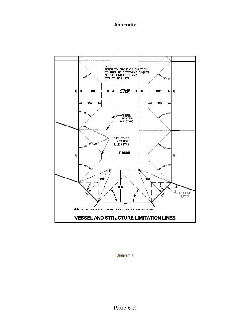
Page 6-28
Appendix

Page 6-29

Page 6-30

Page 6-31

Page 6-32