Chapter 5 – Appendicesa123.g.akamai.net/7/123/11558/abc123/forestservic.download.akamai... ·...
64
Environmental Assessment for Jackson Thinning Chapter 5 – Appendices A. Acronyms ACS – Aquatic Conservation Strategy AMA – Adaptive Management Area ATM – Access and Travel Management BA – Biological Assessment BO – Biological Opinion CEQ – Council on Environmental Quality CHU – critical habitat unit CWD – coarse woody debris dbh – diameter at breast height DNR – Department of Natural Resources EA – Environmental Assessment EO – Executive Order EUI – Ecological Unit Inventory FEIS – Final Environmental Impact Statement FSR – Forest Service Road GIS – Geographic Information Systems GMU – geomorphic mapping unit HPA – hydraulic project approval KV – Knudson-Vandenberg LRMP – Land and Resource Management Plan LSR – Late Successional Reserve LWD – large woody debris MOA – Memorandum of Agreement MOU – Memorandum of Understanding MIS – Management Indicator Species NEPA – National Environmental Policy Act NMFS – National Marine Fisheries Service NOAA – National Oceanic and Atmospheric Administration NWFP – Northwest Forest Plan OAHP – Office of Archeology and Historic Preservation OHV – Off Highway Vehicle OSHA – Occupational Safety and Health Administration PBO – Programmatic Biological Opinion QMD – quadratic mean diameter RDDF – Relative density for Douglas fir 208
Transcript of Chapter 5 – Appendicesa123.g.akamai.net/7/123/11558/abc123/forestservic.download.akamai... ·...

Environmental Assessment for Jackson Thinning
Chapter 5 – Appendices
A. Acronyms ACS – Aquatic Conservation Strategy
AMA – Adaptive Management Area
ATM – Access and Travel Management
BA – Biological Assessment
BO – Biological Opinion
CEQ – Council on Environmental Quality
CHU – critical habitat unit
CWD – coarse woody debris
dbh – diameter at breast height
DNR – Department of Natural Resources
EA – Environmental Assessment
EO – Executive Order
EUI – Ecological Unit Inventory
FEIS – Final Environmental Impact Statement
FSR – Forest Service Road
GIS – Geographic Information Systems
GMU – geomorphic mapping unit
HPA – hydraulic project approval
KV – Knudson-Vandenberg
LRMP – Land and Resource Management Plan
LSR – Late Successional Reserve
LWD – large woody debris
MOA – Memorandum of Agreement
MOU – Memorandum of Understanding
MIS – Management Indicator Species
NEPA – National Environmental Policy Act
NMFS – National Marine Fisheries Service
NOAA – National Oceanic and Atmospheric Administration
NWFP – Northwest Forest Plan
OAHP – Office of Archeology and Historic Preservation
OHV – Off Highway Vehicle
OSHA – Occupational Safety and Health Administration
PBO – Programmatic Biological Opinion
QMD – quadratic mean diameter
RDDF – Relative density for Douglas fir
208

Chapter 5 – Appendices
209
REO – Regional Ecosystem Office
RM – River mile
ROD – Record of Decision
SHPO – State Historic Preservation Office
spp. – species
TES – Threatened and Endangered Species
USDA – United States Department of Agriculture
USDI – United States Department of the Interior
USFS – United States Forest Service
US FWS – United States Fish and Wildlife Service
WDFW – Washington Department of Fish and Wildlife
WEPP – Water Erosion Prediction Project

Chapter 5 – Appendices
210
B. Silvicultural Data
Table 35. Tree layer data (from 2002 stand exam) Overstory Understory
Unit Major Species1
Minor Species
BA2 TPA3 QMD4 Ht5 Age6 YO7 Species TPA QMD Ht8
1 DF WH, WRC, RA, BLM
237.5 370.0 10.8 115 63 1939 WRC, WH, DF
367 1.8 8.4
2 DF, WH WRC, RA
246.0 339.5 11.5 100 52 1950 WRC, WH, DF
326 1.6 8.7
3 DF, WH WRC, RA
246.7 311.6 12.0 116 69 1933 WH, WRC, PY
142 3.0 26.2
4 DF, WH WRC 268.1 395.7 11.1 115 66 1936 WH, WRC, DF, PY
710 1.0 5.6
5 DF WH, WRC, RA, BLM, NBC, BC
232.0 280.6 12.3 120 67 1935 WH, DF, WRC
73 1.1 8.8
6 DF, WRC
WH, RA, BLM
242.7 219.5 14.2 115 719 1930 WRC, WH, DF
240 1.9 12.0
7 WH, DF, WRC
247.5 433.9 10.2 90 56 1946 WH, WRC
200 2.2 11.7
8 DF, WH WRC, PSF, RA, WWP
256.7 302.4 12.5 97 49 1953 WH, WRC
333 1.0 6.2
9 DF, WH WRC, RA
253.3 317.5 12.1 97 71 1931 WH, WRC, DF
67 1.3 6.5
10 WH, DF, PSF
RA, WRC
272.0 407.9 11.0 94 65 1937 PSF, WH, WRC
580 1.9 11.2
11 WH, DF RA, BLM, WRC
297.7 370.5 12.1 106 70 1932 WH, WRC
211 1.9 12.7
16 DF, WH RA, WRC
227.5 234.3 13.3 110 66 1936 WRC, WH
62 0.5 7.0
17 DF, WH WRC, RA, PSF, WWP
252.0 249.6 13.6 98 59 1943 WH, WRC
100 1.4 9.3

Chapter 5 – Appendices
211
Overstory Understory
Unit Major Species1
Minor Species
BA2 TPA3 QMD4
Ht5 Age6 YO7 Species TPA QMD Ht8
18 DF, WH RA, WRC
286.5 409.3 11.3 103
59 1943 WH, WRC, DF
242 2.1 14.5
20 DF, WH WRC 286.6 265.4 14.1 126
103 1899 WH, DF, WRC
242 2.3 12.5
21 DF WH, WRC, BLM
330.0 167.9 18.9 142
114 1888 WH, DF, WWP
25 2.4 16.0
22 DF WH 360.0 173.7 19.5 136
110 1892 WH, DF 67 1.9 12.2
23 DF, WH 310.0 241.3 15.3 106
101 1891 WH, WRC, DF
117 2.2 12.6
24 DF WH, WRC
336.0 178.2 18.6 135
112 1890 WH, DF, WRC, PSF
50 2.3 19.0
Notes: 1. Species with >10% of the stand BA, ordered by predominant basal area: BC=bitter cherry, BLM=bigleaf maple, DF=Douglas-fir, PSF=Pacific silver fir, PY=Pacific yew, RA=red alder, WH=western hemlock, WRC=western redcedar, WWP=western white pine
2. Basal area, sq. ft./ac. 3. Trees per acre 4. Quadratic mean diameter, inches 5. Average height of the tallest measured tree per plot, feet 6. Average total age in 2002, oldest measured tree per plot 7. Year of origin based on total age in 2002 8. Average height in feet, weighted by TPA
9. 5.9 TPA avg 133 years total age.

Environmental Assessment for Jackson Thinning
Table 36. Silvics
Unit D
iam
eter
G
row
th 1
Live Crown Ratio2
Cro
wn
Clo
sure
H/D3 Ratio RDDF
4 RDWH5
Site Class (King, 50-yr index)
SPTH6 (ft) Damage Agents
% TSE Plots with Root Rot
1 1.2 44 80 74 72.3 High 3 174 Root rot, bear, dumping
33
2 1.5 40 95 70 72.5 Mid 3 160 Root rot, bear 23 3 1.4 38 85 75 71.3 0.576 High 3 169 Root rot, bear 17 4 1.7 45 90 79 80.0 0.636 Mid 3 160 Root rot 10 5 1.6 35 85 72 66.2 Mid 3 162 Root rot 20 6 1.6 41 85 69 64.4 0.510 High 3 174 Root rot, bear 27 7 2.2 49 90 77 77.5 0.577 Low 3 150 Bear, hemlock
mistletoe
8 2.3 53 90 71 72.6 0.545 High 3 172 Root rot, bear 25 9 1.7 43 85 70 72.8 0.548 Mid 4 132 Bear, root rot 0
10 1.9 42 95 72 82.0 0.594 Mid 3 163 Wind 11 1.2 42 95 75 85.6 0.662 Low 3 146 Hemlock mistletoe,
root rot 8
16 1.5 42 90 68 62.4 0.475 Low 3 151 Wind, root rot, hemlock mistletoe, bear
07
17 1.8 43 95 71 68.3 0.516 Low 3 146 Bear, root rot 10 18 1.7 29 95 75 85.2 0.654 Mid 3 158 Wind, bear 20 1.2 33 95 67 76.3 0.636 Mid 3 173 Wind, root rot 8 21 1.3 29 95 61 75.9 Low 3 164 Root rot, wind 08
22 1.0 31 80 58 83.5 High 4 155 Root rot 09
23 1.4 31 90 65 79.3 0.610 Mid 4 131 Wind 24 1.4 28 90 58 77.9 High 4 156 Wind, root rot 010
Notes: 1. Inches per decade, trees 8+ inches DBH 2. Trees of average diameter and larger, percentage of tree height 3. Height/Diameter, in feet 4. Curtis Relative Density for Douglas-fir, percentage of maximum 5. Flewelling, Wiley, and Drew Relative Density for western hemlock, fraction of maximum 6. Site Potential Tree Height in feet—95% 300-year potential height growth for DF 7. 17% of walk-through exam points had indicators of root rot 8. 62% of walk-through exam points had indicators of root rot 9. 67% of walk-through exam points had indicators of root rot 10. 43% of walk-through exam points had indicators of root rot
King’s Site Class Height Ranges for 50-year-old Trees Site Class Height Range at Age 50 (feet)Mid 4 81-88
High 4 89-94
Low 3 95-100
Mid 3 101-108
High 3 109-114
212

Chapter 5 – Appendices
213
Table 37. Snags, coarse woody debris, old-growth trees, ground cover, and plant associations.
Snags (from TSE)
Uni
t
Dec Aid
D Class 1
(inches) TPA2 QMD
3
Legacy Snags 4 (TPA)
CWD Cover 5 %
Old-growth Trees? Cover6 Grnd Veg %
Plant Associations7
5.0-10.9 16.8 5.4 11.0-18.9
1.5 18.1 1 SM
19.0+ 3.7 19.9
0 3.0 45 TSHE/GASH-BENE, TSHE/BENE/POMU
5.0-10.9 47.2 6.6 11.0-18.9
3.1 7.8 2 SM
19.0+ 1.4 19.9
1.0 4.8 One patch of 5 trees plus 10-12 legacy snags
37 TSHE/RHMA-GASH, TSHE/GASH-BENE, TSHE/BENE/POMU
5.0-10.9 116 6.5 11.0-18.9
0 0 3 SM
19.0+ 0 0
0.5 3.6 At least three individual or groups of 2-5 DF
45 TSHE/RHMA-GASH, TSHE/BENE/POMU, TSHE/RHMA/POMU
5.0-10.9 23.6 7.8 11.0-18.9
0 0 4 SM
19.0+ 1.0 27.1
1.4 6.6 18 TSHE/RHMA-GASH, TSHE/GASH-BENE
5.0-10.9 32.7 6.7 11.0-18.9
10.9 13.4 5 SM
19.0+ 0.9 32.8
2.0 6.0 40 TSHE/RHMA-GASH
5.0-10.9 37.4 6.3 11.0-18.9 1.6 17.6
6 SM
19.0+ 4.8 22.6
0.5 3.6 Several groups of 2 DF and WRC, plus one patch of 25-30 DF mid-stand
46 TSHE/GASH-BENE, TSHE/BENE/POMU
5.0-10.9 25.7 7.4 11.0-18.9 2.0 18.6
7 SM
19.0+ 0 0
2.5 9.0 3-4 trees and snags NW corner
12 TSHE/RHMA/POMU, TSHE/GASH/POMU
5.0-10.9 0 0 11.0-18.9 3.7 12.8
8 SM
19.0+ 0 0
0.5 15.4 20 TSHE/RHMA/POMU, TSHE/RHMA-BENE
5.0-10.9 0 0 11.0-18.9 7.4 15.7
9 SM
19.0+ 8.5 24.0
3.8 7.2 31 TSHE/RHMA-GASH, TSHE/GASH-POMU, TSHE/RHMA-BENE, TSHE/RHMA/POMU
5.0-10.9 140 6.1 11.0-18.9
0 0 10 SM
19.0+ 0 0
0 15.8 Several trees and snags in “finger” jutting into stand, SW side
7 TSHE/RHMA/POMU, TSHE/BENE/POMU, TSHE/RHMA
5.0-10.9 26.8 7.8 11.0-18.9
0 0 11 SM
19.0+ 0.6 63.8
1.28 7.6 Several WRC and DF in unlogged area E end of stand
10 TSHE/BENE/POMU, TSHE/POMU/TITR
5.0-10.9 0 0 11.0-18.9
0 0 16 SM
19.0+ 0 0
0.7 2.2 50 TSHE/RHMA/POMU, TSHE/RHMA-BENE

Environmental Assessment for Jackson Thinning
Snags (from TSE)
Uni
t
Dec Aid
D Class1 (inches)
TPA2 QMD3
Legacy Snags 4 (TPA)
CWD Cover 5 %
Old-growth Trees? Cover6 Grnd Veg %
Plant Associations7
5.0-10.9 0 0 11.0-18.9
4.1 13.4 17 SM
19.0+ 0 0
2.5 3.8 60 TSHE/RHMA-BENE, TSHE/RHMA-GASH, TSHE/RHMA/POMU
5.0-10.9 131.5 6.1 11.0-18.9
13.7 13.3 18 SM
19.0+ 2.1 29.5
09 8.7 10 TSHE/RHMA/POMU, TSHE/RHMA-BENE, TSHE/BENE/POMU
5.0-10.9 106 7.2 11.0-18.9
16.6 13.5 20 SM-
LT10
19.0+ 1.7 26.9
4.0 8.0 1911 TSHE/RHMA, TSHE/RHMA-BENE, TSHE/RHMA/POMU
5.0-10.9 0 0 11.0-18.9
4.5 11.6 21 SM-
LT12
19.0+ 0 0
0 3.5 82 TSHE/GASH/POMU, TSHE/RHMA-GASH
5.0-10.9 0 0 11.0-18.9
6.214 14.1 22 SM-
LT13
19.0+ 0 0
0 2.1 88 TSHE/GASH/POMU, TSHE/RHMA-GASH, TSHE/RHMA/POMU
5.0-10.9 38.9 6.9 11.0-18.9
6.8 13.4 23 SM
19.0+ 2.6 21.7
0.9 4.2 67 TSHE/RHMA-GASH, TSHE/RHMA-BENE
5.0-10.9 20.4 6.0 11.0-18.9
12.9 13.1 24 SM-
LT15
19.0+ 0 0
0 3.1 85 TSHE/RHMA-GASH
Notes: 1. Diameter Class 2. Trees Per Acre 3. Quadratic Mean Diameter 4. Trees Per Acre, from Winter 2006 walk-through exams 5. Coarse Woody Debris ground cover, from Winter 2006 walk-through exams 6. Shrub and herb (Ground Veg) cover, from Winter 2006 walk-through exams 7. From Winter 2006 walk-through exams: BENE=Oregon grape, GASH=salal, POMU=swordfern,
RHMA=rhododendron, TITR=three-leaf foamflower, TSHE=western hemlock 8. 0.5 legacy snags per acre if unlogged portion on east end of stand is excluded 9. While no legacy snags were observed during the walk-through exam, the formal stand exam’s 2.1
snags per acre in the 19+ size class are most likely legacy snags. 10. The 90 biggest trees/acre had a QMD of 20.1 inches. 11. 32% cover lower N and NW sides; 6% cover upper S and E sides 12. The 100 biggest trees/acre had a QMD of 22.4 inches. 13. The 109 biggest trees/acre had a QMD of 22.9 inches. 14. This number may be low—the walk-through exam revealed more and larger snags present 15. The 130 biggest trees/acre had a QMD of 20.7 inches.
214

Chapter 5 – Appendices
215
Table 38. Blowdown Risk Assessment Blowdown Risk Assessment
Stand
Risk Factor 1 2 3 4 5 6 7 8 9 10
11
16
17
18
20
21
22
23
24
1. Predominantly hemlock and Sitka spruce stands – shallow rooting (Harris, 1989)
X X
2. Hemlock/spruce stands on mound and pit topography or with a high percentage of trees growing on old stumps and/or down logs (history of blowdown)
3. Where gaps are created that allow storm winds to channel into the stand (Smith, 1962)
1
X 1
X 1
X1
X1
X1
X1
X1
X1
X1
X1
X1
X1
X 1
X 2 2
3
X2 2
4. Heavily thinned stands (Harris, 1989)
5. Stands adjacent to clearcuts that occur within a year or two after thinning (Kugel Thin, 1992-93)
6. Stands with H/D ratios approaching or exceeding 100 (Oliver)
7. Large flats (David Peter, Sol Duc Watershed Analysis, 1995)
8. Exposure to storm winds (Harris, 1989) X X X X X X X X X X
9. Wet soils (David Peter, Sol Duc Watershed Analysis, 1995)
10. Shallow soils to impervious layer (Harris, 1989)
11. Stands that have not been thinned in the past (Smith, 1962)
X X X X X X X X X X X X X
12. Narrow buffer strips between clearcuts and roads
13. Stands extensively infected with root rots X X X X X X
Number of Risk Factors 4 1 2 1 3 4 4 2 1 3 2 2 1 2 2 3 4 2 3 Overall Blowdown Risk M L L L L M M L L M L L L L L M M L M

Environmental Assessment for Jackson Thinning
Table 39. Stand prescription notes. U
nit Boundaries Other Skip Areas Diameter
Limits Other
1 Specified riparian no-cut buffer along Rocky Brook
100 ft no-cut buffer around identified remnant old-growth (OG) trees
20" upper 8" lower
Lay out small clearcuts in 5 identified Phellinus pockets up to 1.5 ac Allow thinning among cedars (only cedars to "cut" other cedars) above 2620 Rd Allow thinning among hardwoods (only hardwoods to "cut" other hardwoods); cut 20 ft radius around BLM >16 in DBH
2 Specified riparian no-cut buffer along Rocky Brook
100 ft no-cut buffer around OG trees SW side
20" upper 8" lower
3 100 ft no-cut buffer around OG trees in middle and W end
20" upper 8" lower
Lay out small clearcuts in 3 identified Phellinus pockets up to 1.5 ac
4 100 ft no-cut buffer around identified OG tree(s)
20" upper 8" lower
5 Doghair patch upper mid stand; Rock outcrops SE corner; 100 ft no-cut buffer around identified OG tree(s)
20" upper 8" lower
6 Boundary out park-like alder patch lower NW end adjacent to Stand 5
100 ft no-cut buffer around several OG trees, small groups, OG patch.
20" upper 8" lower
Allow thinning among cedars where dense
7 Brushy areas and legacy snag patch area between converging streams SW side; 100 ft no-cut buffer around identified OG tree(s)
20" upper 8" lower
8 Avoid older, unlogged stand along SW edge
100 ft no-cut buffer around identified OG tree(s)
20" upper 8" lower
9 Alder patch NE corner; 100 ft no-cut buffer around identified OG tree(s)
20" upper 8" lower
216

Chapter 5 – Appendices
217
U
nit
Boundaries Other Skip Areas Diameter Limits
Other
10 Avoid finger of DF OG trees and snags SW side
20" upper 8" lower
11 Boundary out unlogged natural stand area at E end; Also area already thinned by Turner CT in 1986
1-2 ac triangle bounded by Jackson Ck, Turner CT stand, and 2620030
20" upper 8" lower
Move temp road location to avoid 60" OG DF at E end of stand
16 20" upper 8" lower
17 1 ac area short, small trees N side of stand
20" upper 8" lower
PSF and WWP would be additional "ghost trees" (besides RA and WRC)
18 20" upper 8" lower
20 No-cut buffers around blowdown patches N ridge and SE draw
24" upper 8" lower
21 Pull unit boundary in 66 feet from ownership bndy
100 ft no-cut buffer around identified OG tree(s)
24" upper 8" lower
22 Area between trail and stream plus 66 ft no-cut buffer along trail
26" upper 10" lower
WH would be additional "ghost tree"
23 Pull unit boundary in 66 feet from ownership bndy
Rock outcrops near ridge
24" upper 8" lower
24 Pull unit boundary in 66 feet from ownership bndy
24" upper 8" lower
WH would be additional "ghost tree"

Chapter 5 – Appendices
218
C. Summary Tables of Roads Proposed for Use35
Table 40. Temporary Roads Proposed for Use
Route # Road Type Proposed Road Use
Post Harvest Treatment
Alt. A (miles)
Alt. B (miles)
Alt. C (miles)
Alt. D (miles)
2620001 New temporary rd Temporary rd Decommission 0.1 0.1 0.1 0.1 2620002 New temporary rd Temporary rd Decommission 0.1 0.1 0.1 0.1 2620044 Decommissioned rd Temporary rd Decommission 0.4 0.4 0.0 0.4 2620046 Decommissioned rd Temporary rd Decommission 0.2 0.2 0.0 0.2 2620105 New temporary rd Temporary rd Decommission 0.3 0.3 0.0 0.3 2620106 New temporary rd Temporary rd Decommission 0.6 0.0 0.0 0.0 2620107 New temporary rd Temporary rd Decommission 0.8 0.8 0.0 0.8 2620110 New temporary rd Temporary rd Decommission 0.4 0.4 0.0 0.4 2620111 New temporary rd Temporary rd Decommission 0.4 0.4 0.0 0.4 2620119 Decommissioned rd Temporary rd Decommission 0.4 0.4 0.0 0.0 2620122 New temporary rd Temporary rd Decommission 0.1 0.1 0.1 0.1 2730015 New temporary rd Temporary rd Decommission 0.1 0.0 0.1 0.1 2730034 New temporary rd Temporary rd Decommission 0.03 0.0 0.0 0.0 2730035 New temporary rd Temporary rd Decommission 0.04 0.0 0.0 0.0
Total new
temp roads 3.8 3.1 0.4 3.2
2620104 Unclassified, abandoned rd Temporary rd Decommission 0.1 0.1 0.1 0.1 2620107 Unclassified, abandoned rd Temporary rd Decommission 0.1 0.1 0.0 0.1 2620108 Unclassified, abandoned rd Temporary rd Decommission 0.7 0.7 0.0 0.7 2620109 Unclassified, abandoned rd Temporary rd Decommission 0.4 0.4 0.0 0.0 2620110 Unclassified, abandoned rd Temporary rd Decommission 0.2 0.2 0.0 0.2 2620115 Unclassified, abandoned rd Temporary rd Decommission 0.2 0.2 0.0 0.2 2620116 Unclassified, abandoned rd Temporary rd Decommission 0.3 0.3 0.0 0.3 2620117 Unclassified, abandoned rd Temporary rd Decommission 0.2 0.2 0.2 0.2 2620117 Unclassified, abandoned rd Temporary rd Decommission 0.1 0.1 0.1 0.1 2630020 Unclassified, abandoned rd Temporary rd Decommission 0.4 0.4 0.0 0.4
Total unclassified, abandoned rd 2.4 2.4 0.4 2.0
Total Temp.
Roads 6.2 5.5 0.7 5.2
35 Values given are approximate and based on computer mapping and other calculations. These values may differ from actual project layout and implementation.

Chapter 5 – Appendices
219
Table 41. Summary table of system roads proposed for use.
Route # Current Operational Maintenance Level
Work Proposed (if used as part of
alternative)
Post Harvest Maintenance
Level Alt. A
(miles) Alt. B
(miles) Alt. C
(miles) Alt. D
(miles) 2620 Level 2 spot surfacing Level 2 11.6 11.6 11.6 11.6
2620030 Level 2 spot surfacing, culvert
replacements Level 2 9.7 9.7 9.7 9.7 2620032 Level 2 spot surfacing Level 2 0.0 0.0 0.5 0.5 2620034 Level 1 spot surfacing Level 1 0.1 0.1 0.1 0.1 2620035 Level 2 spot surfacing Level 2 1.0 1.0 1.0 1.0 2620050 Level 2 spot surfacing Level 2 0.1 0.1 0.1 0.1
2620051 Level 2 spot surfacing
Level 1; decommission if
funds are available 0.3 0.3 0.3 0.3
2620060 Level 2 spot surfacing Level 2 1.5 1.5 1.5 1.5
2630 Level 2 spot surfacing, culvert
replacements Level 2 4.9 4.9 4.9 4.9
2630020 Level 2 spot surfacing
Level 1; decommission if
funds are available 0.9 0.9 0.9 0.9
2730 Level 3 spot surfacing Level 3 3.8 0.0 3.8 3.8 2730011 Level 2 spot surfacing Level 2 0.6 0.0 0.6 0.6
Total System
Roads = 34.5 30.1 35.0 35.0
Total Temporary & System Roads = 43.3 38.2 35.8 40.2

D. Road Definitions Forest roads. As defined in Title 23, Section 101 of the United States Code (23 U.S.C. 101), any road wholly or partly within, or adjacent to, and serving the National Forest System and which is necessary for the protection, administration, and utilization of the National Forest System and the use and development of its resources.
National Forest System road. A classified forest road under the jurisdiction of the Forest Service. The term “National Forest System roads” is synonymous with the term “forest development roads” as used in 23 U.S.C. 205.
New Road Construction. Activity that results in the addition of forest classified or temporary road miles (36 CFR 212.1).
Public roads. Any road or street under the jurisdiction of and maintained by a public authority and open to public travel (23 U.S.C. 101(a)).
Road. A motor vehicle travel way over 50 inches wide, unless designated and managed as a trail. A road may be classified, unclassified, or temporary (36 CFR 212.1).
a. Classified Roads. Roads wholly or partially within or adjacent to National Forest System lands that are determined to be needed for long-term motor vehicle access, including State roads, county roads, privately owned roads, National Forest System roads, and other roads authorized by the Forest Service (36 CFR 212.1).
b. Temporary Roads. Roads authorized by contract, permit, lease, other written authorization, or emergency operation not intended to be a part of the forest transportation system and not necessary for long-term resource management (36 CFR 212.1).
c. Unclassified Roads. Roads on National Forest System lands that are not managed as part of the forest transportation system, such as unplanned roads, abandoned travel ways, and off-road vehicle tracks that have not been designated and managed as a trail; and those roads that were once under permit or other authorization and were not decommissioned upon the termination of the authorization (36 CFR 212.1).
Road Decommissioning. Activities that result in the stabilization and restoration of unneeded roads to a more natural state (36 CFR 212.1), (FSM 7703).
Decommissioning includes applying various treatments, which may include one or more of the following:
a. Reestablishing former drainage patterns, stabilizing slopes, and restoring vegetation;
220

Chapter 5 – Appendices
221
b. Blocking the entrance to a road;
c. Removing culverts, installing water bars and reestablishing drainage-ways, removing unstable fills, pulling back road shoulders, and scattering slash on the roadbed;
d. Completely eliminating the roadbed by restoring natural contours and slopes; or other methods designed to meet the specific conditions associated with the unneeded roads.
Road maintenance. The ongoing upkeep of a road necessary to retain or restore the road to the approved road management objective (FSM 7712.3).
Road maintenance level. Maintenance levels define the level of service provided by, and maintenance required for, a specific road. Maintenance levels must be consistent with road management objectives and maintenance criteria. There are road five maintenance levels:
a. Level 1. Assigned to intermittent service roads during the time they are closed to vehicular traffic. The closure period must exceed 1 year. Basic custodial maintenance is performed to keep damage to adjacent resources to an acceptable level and to perpetuate the road to facilitate future management activities. Emphasis is normally given to maintaining drainage facilities and runoff patterns. Planned road deterioration may occur at this level.
b. Level 2. Assigned to roads open for use by high clearance vehicles. Passenger car traffic is not a consideration. Traffic is normally minor, usually consisting of one or a combination of administrative, permitted, dispersed recreation, or other specialized uses. Log haul may occur at this level.
c. Level 3. Assigned to roads open and maintained for travel by a prudent driver in a standard passenger car. User comfort and convenience are not considered priorities.
d. Level 4. Assigned to roads that provide a moderate degree of user comfort and convenience at moderate travel speeds.
e. Level 5. Assigned to roads that provide a high degree of user comfort and convenience.
Road Reconstruction. Activity that results in improvement or realignment of an existing road36
36 For the purposes of this analysis, the term reconstruction is used to reference construction on system roads, as well as unclassified, abandoned road grades.

Chapter 5 – Appendices
222
E. Response to Comments
Topic Comment Author Response
Agency mandate Under the Organic Act of 1897 and the Multiple Sustained Yield Act of 1960, the U.S. Forest Service is mandated to manage the land for a variety of uses, including timber production, wildlife, and recreation uses. We urge the Olympic National Forest to proceed with this project and others that have like goals.
Malcolm Dick, Jr (American Forest Resource Council)
Thank you for your comment.
Alternatives We are very happy to see Units 13 and 14 on the east slope of Mt. Turner dropped from consideration. Unit 6, however, is an LSR stand that could be considered over 80 years old, already exhibits a suite of late successional characteristics, is designated critical habitat with “potential constituent elements” for marbled murrelets and, thus, should also be dropped from consideration for thinning.
Jim Scarborough (Olympic Forest Coalition), Tim McNulty (Olympic Park Associates)
Thank you for your comment. Based on stand exam tree data, the year of origin for the majority of the stand is 1930, which is the basis for determining stand age. Due to 1) the amount of potential murrelet nest and legacy trees exist through much of Unit 6 and a portion of Unit 1 that would be buffered and not cut under any alternative and 2) the nearness of Unit 6 to the 80 year age limit for silvicultural treatments, all of Unit 6 and the southernmost portion of Unit 1 are dropped from the final decision.

Chapter 5 – Appendices
223
Topic Comment Author Response
Alternatives Support for Alternative A. The only reason to choose Alternative B is to appease the radical environmental groups and the closet radical environmentalists within the Forest Service. There are both rules concerning habitat protection, as well as putting up economically feasible (i.e., profitable thinning projects) to potential bidders. Don’t exclude quality wood (i.e., “older wood”) from the project.
Eric Bower (Bower Logging)
Thank you for your comment.
Alternatives Support for Alternative A because: 1) the age class of timber proposed for this thinning has significant economic value, 2) we support the thinning of the maximum number of acres, 3) this proposed thinning will produce both economic and ecological benefits, and 4) the long tern gain of this project will mitigate any short term loss of recreational opportunities. We do not support Alternative B, C, or D because of the smaller acreage to be treated and the decommissioning of roads. Alternative C and the
Carol Johnson (North Olympic Timber Action Committee)
Thank you for your comment.

Topic Comment Author Response
proposed minimal use of roads would indicate the greater use of helicopter logging, which would greatly increase costs and decrease revenue.
Alternatives Support for the No Action Alternative or Alternative B. Both of these alternatives would protect Mt. Walker and Unit 6. Mt. Walker serves as a beacon for visitors to the Quilcene area. Thinning on Mt. Walker would impact tourism, local recreation opportunities, and aesthetics. There is also concern regarding sediment-related impacts to water quality.
Mike Anderson (Quilcene, WA); Connie Gallant (RV Consumer Group, Quilcene Citizens Coalition, Olympic Forest Coalition, Jefferson County Democrats); Shirley Smith-Moore (Brinnon, WA); JD Gallant (Jefferson County Planning Commissioner); Eric Anderson and Sandy Shea (Quilcene,
Thank you for your comment.
224

Chapter 5 – Appendices
225
Topic Comment Author Response
WA); Hazel Munday (Brinnon, WA); Donna Winter (Pt. Townsend, WA); Kristin Olson (Quilcene, WA); Larry and Arleen Schinke for the Jay Schinke Family, Adams Family, Favro Family, Rollo Family, Stark Family, Hall Family, and Patricelli Family
Alternatives Support Alternative C. Having hiked extensively in the Mt. Walker area, I recognize that the forest on Mt. Walker is not a climax old growth forest. There are many doghair stands that should be thinned to promote growth of older trees and reduce the catastrophic fire hazard. This alternative would accomplish the thinning without building new roads as recommended
Graham Wright (Hollister, CA)
Thank you for your comment.

Topic Comment Author Response
in the other alternatives.
Alternatives Support Alternative B because it would fairly accomplish the U.S. Forest Service goals while somewhat protecting the watershed above us. Our cabin’s water is supplied by a gravity spring system and is very vulnerable to excessive runoff caused by logging and road construction.
Ed and Kate Kennell (part-time resident and landowner on the west side of Dabob Bay at the base of Mt. Walker)
Thank you for your comment.
Alternatives Support Alternative B because it would have the least environmental impact. Jefferson county is heavily dependent upon the tourism generated by the natural beauty of our forestlands, particularly the vistas, trails, and campsites adjacent to Highway 101 and around Mt. Walker.
John Austin (Jefferson County Commissioner)
Thank you for your comment.
Alternatives Favor whichever alternative decommissions the most roads and reserves the use of helicopters for areas most unfeasible for cable or road-based logging activities.
Rory Henneck (Seattle, WA)
Thank you for your comment.
226

Chapter 5 – Appendices
227
Topic Comment Author Response
Alternatives Oppose any timber thinning in the proposed areas at this time.
Hazel Munday (Brinnon, WA), Bill Summers (Pt. Angeles, WA), Nancy Davies (Lilliwaup, WA)
Thank you for your comment.
Alternatives Support Alternative B because, while it is difficult to distinguish between “thinning” by the U.S. Forest Service and DNS and clearcutting by the logging industry, it would be marginally better for the environment.
John and Carole Gusoskey (Quilcene, WA)
Thank you for your comment.
Alternatives Preference to not thin on Mt. Walker, but by thinning 25% instead of 33% and tagging trees to be cut, a compromise for the good of all parties is possible.
Dick and Leah Jo Patricelli (Quilcene, WA)
Thank you for your comment. Doing a lighter thinning as you suggest may not allow enough light through the forest canopy to stimulate growth of understory plants or the development of multiple canopy layers, which are components of the late successional and old growth habitat characteristics that this project seeks to develop. In general, approximately 60%-90% canopy would still be maintained across the treated units under the project’s thinning prescription. Research also shows that the level of thinning would be light enough to limit blowdown subsequent to thinning. While individual trees will not be tagged, compliance with harvest specifications are still verifiable by examining the stumps of the cut trees, which indicate tree sizes, tree species, and number and spacing of trees cut.
Alternatives Encourage the Forest Service to avoid logging the area that contains the hiking trail and to
Hal Beattie (Brinnon, WA)
Thank you for your comment. Thinning treatments on Mt. Walker is not included in the final decision.

Topic Comment Author Response
leave a buffer around the road. Believe that Alternative B would address this concern.
Measures, however, such as having a 66-foot no-cut buffer around the Mt. Walker trail and minimizing disturbance within 100-feet of the trail were incorporated into all alternatives that considered thinning on Mt. Walker.
Alternatives Support the Jackson Thinning project at the highest output level for the following reasons: 1) Judicial timber harvest substantially will broaden flora quality and quantity and fauna; 2) Timber production is among the multiple uses mandated for National Forests and will provide employment as well as domestic, rather than imported, forest products; and 3) Harvest will enhance recreation and visual opportunities for permanent residents and visitors alike.
Malcolm Dick, Jr (American Forest Resource Council)
Thank you for your comment.
Alternatives Support for Alternative B Duane Worthington, Rebekah Ross (Brinnon, WA), John Kennell, Patricia Thomsen (Quilcene, WA)
Thank you for your comment.
Alternatives Support for Alternative B to protect the recreation opportunities provided by Mt. Walker.
Penelope Hill Walker (Brinnon, WA)
Thank you for your comment.
228

Chapter 5 – Appendices
229
Topic Comment Author Response
Alternatives Support for Alternative B because of sediment and water quality concerns.
Cathy Kain (Quilcene, WA)
Thank you for your comment.
Alternatives Support for Alternative A for the long term health of our forests.
Davis Steelquist (Quilcene, WA)
Thank you for your comment.
Alternatives Support for Alternative B. This alternative would still allow thinning on approximately 1600 acres. Mt. Walker is a source of great pride and joy. Do not let it become yet another one of the U.S. Forest Service’s clearcut eyesores.
Jane Hall-Lazelle and Keith Lazelle (Quilcene, WA)
Thank you for your comment. The Olympic National Forest, however, stopped clearcutting over 12 years ago and is often assumed to be responsible for activities on state and private land. This project does not propose to clear cut forest. Trees are being proposed for removal to enhance the diversity of the understory and the structural diversity of the forest. Rather than a “clearcut eyesore,” this project would not be noticeable to casual visitors after implementation of the thinning. Please see the visual quality section of the environmental assessment (EA p. 180-187) for descriptions, pictures, and modeling results, particularly for Mt. Walker.
Alternatives Recommend a hybridized version of Alternatives B and C without the inclusion of Unit 6. An acceptable sale would include the majority of units in Alternative B’s original non-modified form, but accessed through the methods stipulated in Alternative C – with minimal road construction/reconstruction and liberal use of helicopters for the purpose of riparian/aquatic integrity. However, an additional request is to remove the
Jim Scarborough (Olympic Forest Coalition), Marcy Golde (Seattle, WA) , Tim McNulty (Olympic Park Associates)
Thank you for your comment.
Topic Comment Author Response
planned 0.3 miles of road reconstruction within Riparian Reserve that is included in Alternative C.
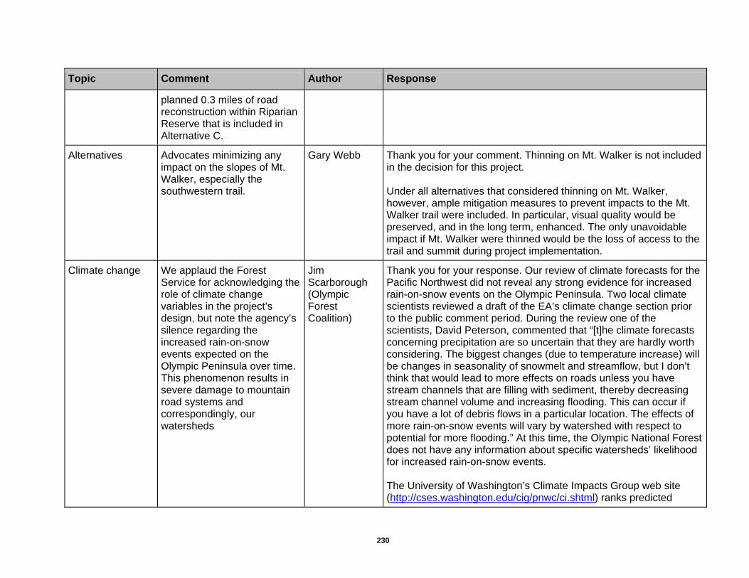
Alternatives Advocates minimizing any impact on the slopes of Mt. Walker, especially the southwestern trail.
Gary Webb Thank you for your comment. Thinning on Mt. Walker is not included in the decision for this project. Under all alternatives that considered thinning on Mt. Walker, however, ample mitigation measures to prevent impacts to the Mt. Walker trail were included. In particular, visual quality would be preserved, and in the long term, enhanced. The only unavoidable impact if Mt. Walker were thinned would be the loss of access to the trail and summit during project implementation.
Climate change We applaud the Forest Service for acknowledging the role of climate change variables in the project’s design, but note the agency’s silence regarding the increased rain-on-snow events expected on the Olympic Peninsula over time. This phenomenon results in severe damage to mountain road systems and correspondingly, our watersheds
Jim Scarborough (Olympic Forest Coalition)
Thank you for your response. Our review of climate forecasts for the Pacific Northwest did not reveal any strong evidence for increased rain-on-snow events on the Olympic Peninsula. Two local climate scientists reviewed a draft of the EA’s climate change section prior to the public comment period. During the review one of the scientists, David Peterson, commented that “[t]he climate forecasts concerning precipitation are so uncertain that they are hardly worth considering. The biggest changes (due to temperature increase) will be changes in seasonality of snowmelt and streamflow, but I don’t think that would lead to more effects on roads unless you have stream channels that are filling with sediment, thereby decreasing stream channel volume and increasing flooding. This can occur if you have a lot of debris flows in a particular location. The effects of more rain-on-snow events will vary by watershed with respect to potential for more flooding.” At this time, the Olympic National Forest does not have any information about specific watersheds’ likelihood for increased rain-on-snow events. The University of Washington’s Climate Impacts Group web site (http://cses.washington.edu/cig/pnwc/ci.shtml) ranks predicted
230

Chapter 5 – Appendices
231
Topic Comment Author Response
impacts from climate change by confidence level. The likelihood of winter flooding in rain-dominated basins and coastal flooding were given a medium confidence level. Annual streamflow volumes and landslides were assigned to the lowest confidence level. No road-related impacts due to climate change are expected, however, given that this project is likely to be completed within the next five to ten years, and mitigation measures for this project require that all road culverts in place for longer than one year must accommodate 100-year flows.
Economics Mt. Walker is an asset to the community, and the thinning would have a major and adverse economic impact to the local area.
JD Gallant (Jefferson County Planning Commissioner)
Thank you for your comment.
Economics The EA does not provide cost or revenue assumptions, including economic analysis by road segments. The Tee EA from the Gifford Pinchot National Forest provided one of the best economic sections and can be used as an example.
Derek Churchill (Conservation Northwest)
As stated in the EA, the economic analysis was determined using the Forest Service’s regional TEA.ECON economic analysis tool. This tool is made up of 10 spreadsheets of calculations for each alternative. While underlying assumptions can be disclosed, detailed descriptions of the analysis are difficult to present in the EA. For those who are interested, however, the analysis information is always available upon request.

Topic Comment Author Response
Ecosystems Mt. Walker should be left undisturbed and left to develop into old growth habitat on its own.
Mike Anderson (Quilcene, WA), Christie Taylor (Chimacum, WA), Jim Scarborough (Olympic Forest Coalition)
Thank you for your comment.
Ecosystems Concerned about cutting trees that support the ecosystem, and are part of the pristine beauty, clean air, and lifestyle that the Peninsula provides.
Shirley Smith-More (Brinnon, WA)
Thank you for your comment. We also value healthy ecosystems, and seek to use the same tool of cutting trees in a different way to develop habitats (late successional and old-growth habitats) that past clear cut logging eliminated.
Environmental assessment
This EA is impressive in both scope and detail, while assisting the reader to better understand the questions and issues involved in what is indisputably a large project. The current EA reflects a good bit of work by your staff as well as input from the environmental community. It is a comprehensive document, and we appreciate your effort.
Jim Scarborough (Olympic Forest Coalition), Tim McNulty (Olympic Park Associates)
Thank you for your comment.
232
Chapter 5 – Appendices
233
Topic Comment Author Response
Environmental impact
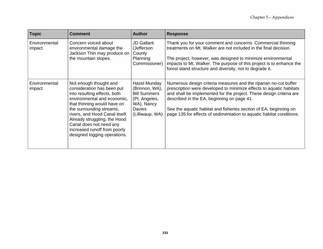
Concern voiced about environmental damage the Jackson Thin may produce on the mountain slopes.
JD Gallant (Jefferson County Planning Commissioner)
Thank you for your comment and concerns. Commercial thinning treatments on Mt. Walker are not included in the final decision. The project, however, was designed to minimize environmental impacts to Mt. Walker. The purpose of this project is to enhance the forest stand structure and diversity, not to degrade it.
Environmental impact
Not enough thought and consideration has been put into resulting effects, both environmental and economic, that thinning would have on the surrounding streams, rivers, and Hood Canal itself. Already struggling, the Hood Canal does not need any increased runoff from poorly designed logging operations.
Hazel Munday (Brinnon, WA), Bill Summers (Pt. Angeles, WA), Nancy Davies (Lilliwaup, WA)
Numerous design criteria measures and the riparian no-cut buffer prescription were developed to minimize effects to aquatic habitats and shall be implemented for the project. These design criteria are described in the EA, beginning on page 41.
See the aquatic habitat and fisheries section of EA, beginning on page 135 for effects of sedimentation to aquatic habitat conditions.

Topic Comment Author Response
Environmental impact
With respect to public concerns that thinning fire regenerated stands over 80 years old may harm, rather than help, natural development of those stands, a properly managed thinning operation has a low failure risk. An operational failure in any one operation is not a disaster. We revel in our successes, but we learn from our mistakes
Malcolm Dick, Jr (American Forest Resource Council)
Thank you for your comment.
Fire A major concern is that if more thinning is done it will open up the canopy, which would allow for the forest floor to dry up quicker, making it more susceptible to combustion. It would behoove all residents of Quilcene and Brinnon not to have any forest fires because, as witnessed in other areas of the country, fires are very unpredictable and can quickly wipe out large areas of wilderness and human habitat.
Connie Gallant (RV Consumer Group, Quilcene Citizens Coalition, Olympic Forest Coalition, Jefferson County Democrats)
Fuels Management Analysis Program Plus (FMA Plus) was used to model the potential fire behavior and fire size prior to treatment and post treatment in the proposed project area. FMA Plus uses fuel moistures and the amount of fuel in tons per acre in various size classes to predict potential fire behavior and fire size. Modeling was done for pre- treatment and post treatment conditions in the proposed project area. The fuel moistures used in the modeling of the potential fire size and behavior only occur 10 percent or less of the time between the months June through September at local weather stations. Although thinning will allow more sunlight and wind to the ground they should not reduce the fuel moistures below those used in the fire modeling The leading cause of fires on the Olympic National Forest is human activities. (i.e., camping, vehicles, and smoking). The mitigation measures in the EA are designed to limit the risk of humans caused fires and to allow local resources to be effective during initial attack.
234

Chapter 5 – Appendices
235
Topic Comment Author Response
Implementation Concern that the environmental assessment does not address human factors such as enforcement of standards for contractors that will complete the thinning itself. Concern voiced that limited supervision by the Forest Service will not adequately protect the species and ecological function that this report addresses. This is because the plants, distance and size designations, and masses are often difficult to determine by the technician in the field
Rory Henneck (Seattle, WA)
Thank you for your comment. The timber sale administration team on the Olympic National Forest is highly trained in contract law and compliance. The thinning prescriptions and cutting guidelines are written to a specific standard which does not allow the contractor any variance. Cutting guidelines are monitored on the ground for compliance; any deviation by the contractor would result in breach of contract, and/or a timber theft investigation by federal law enforcement personnel, and/or disbarment.

Topic Comment Author Response
Implementation Trees to be thinned should be tagged. We are not convinced that any logging company existing today is capable of following the contract to the letter and the intent of the contract when they are allowed the choice of what to cut. Weekly inspections are totally inadequate when it comes to managing a for-profit company that is allowed the freedom to make those selections. Daily inspections may not even be enough. We see no way you could feel comfortable in managing a cut of this magnitude without pinning the loggers to only cut trees you have marked. It is a big job, but the no tagging method seems clearly inadequate for this area.
Dick and Leah Jo Patricelli (Quilcene, WA)
As stated in the previous response, the timber sale administration team on the Olympic National Forest is highly trained in contract law and compliance. The thinning prescriptions and cutting guidelines are written to a specific standard which does not allow the contractor any variance. Cutting guidelines are monitored on the ground for compliance; any deviation by the contractor would result in breach of contract, and/or a timber theft investigation by federal law enforcement personnel, and/or disbarment.
Landscape Analysis
Considerable landscape level analysis is included, both new analysis and from the watershed analyses and LSR assessment. Doing even more landscape level analysis is strongly encouraged for subsequent planning areas.
Derek Churchill (Conservation Northwest)
Thank you for your comment. A more detailed explanation, however, would be helpful to understand what additional landscape level analysis is suggested and the specific concerns that such analysis would address.
236
Chapter 5 – Appendices
237
Topic Comment Author Response
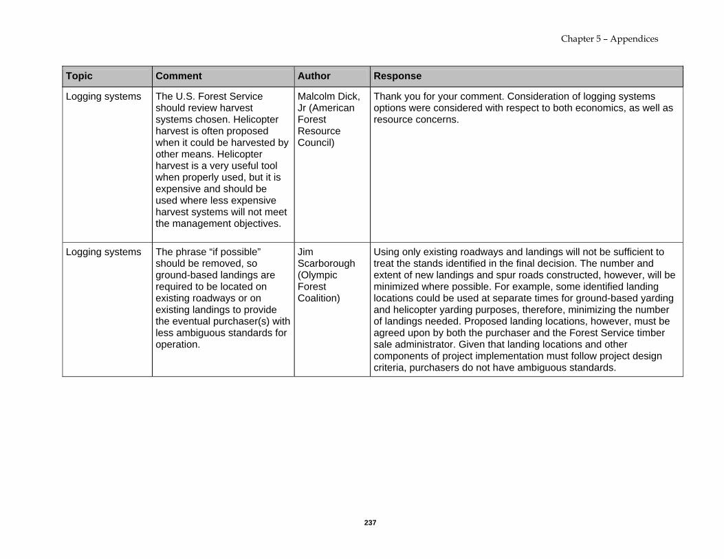
Logging systems The U.S. Forest Service should review harvest systems chosen. Helicopter harvest is often proposed when it could be harvested by other means. Helicopter harvest is a very useful tool when properly used, but it is expensive and should be used where less expensive harvest systems will not meet the management objectives.
Malcolm Dick, Jr (American Forest Resource Council)
Thank you for your comment. Consideration of logging systems options were considered with respect to both economics, as well as resource concerns.
Logging systems The phrase “if possible” should be removed, so ground-based landings are required to be located on existing roadways or on existing landings to provide the eventual purchaser(s) with less ambiguous standards for operation.
Jim Scarborough (Olympic Forest Coalition)
Using only existing roadways and landings will not be sufficient to treat the stands identified in the final decision. The number and extent of new landings and spur roads constructed, however, will be minimized where possible. For example, some identified landing locations could be used at separate times for ground-based yarding and helicopter yarding purposes, therefore, minimizing the number of landings needed. Proposed landing locations, however, must be agreed upon by both the purchaser and the Forest Service timber sale administrator. Given that landing locations and other components of project implementation must follow project design criteria, purchasers do not have ambiguous standards.

Topic Comment Author Response
Northwest Forest Plan
Dispute the statement on p. 15 of the environmental assessment that “timber activities on the Olympic National Forest are well within the guidelines of the Northwest Forest Plan. The Forest Service has a chronic disregard of Riparian Reserves (with repeated instances of these zones being roaded and logged), cumulatively dozens of miles of legally discouraged road construction in LSRs, and the agency’s stated intent to boost annual timber volume three-fold beyond that intended in the Northwest Forest Plan.
Jim Scarborough (Olympic Forest Coalition)
Despite popular interpretations, the Northwest Forest Plan’s purpose is to meet the needs of both providing forest habitat and timber products. Riparian Reserve designations are not intended to prohibit silvicultural treatments. The Northwest Forest Plan standards and guidelines for Riparian Reserves states the following for timber management, "Apply silvicultural practices for Riparian Reserves to control stocking, reestablish and manage stands, and acquire desired vegetation characteristics needed to attain Aquatic Conservation Strategy objectives" (C-32). The objective of this project includes enhancing forest stand structure and plant diversity in Riparian Reserve while protecting aquatic habitat. No-cut buffers within Riparian Reserves are designated to protect fish habitat and/or water quality from ground disturbance (EA p. 22). While road construction is discouraged in the Northwest Forest Plan, it is not prohibited in either Late Successional Reserves or Riparian Reserves (see p. C-16 and C-32 of the 1994 Standards and Guidelines for Management of Habitat for Late-Successional and Old-Growth Forest Related Species Within the Range of the Northern Spotted Owl). Careful consideration was given to the proposed roads and associated logging system in the planning area.
238

Chapter 5 – Appendices
239
Topic Comment Author Response
Recreation Not only does Mt. Walker serve as a tourist destination for the area, it also provides recreational opportunities for Olympic Peninsula locals. Mt. Walker is one of the few, pristine, and tranquil places that are accessible to anyone in the general public, as it’s accessible by trail and automobile.
Allan and Mary Kollar (Quilcene, WA), Donna Winter (Pt. Townsend, WA), Bill Summers (Pt. Angeles, WA), Nancy Davies (Lilliwaup, WA), Libby Pease (former Brinnon resident), Hal Beattie (Brinnon, WA), Rebekah Ross (Brinnon, WA), Penelope Hill Walker (Brinnon, WA), Gary Webb, Nancy Gannon (Lilliwaup, WA)
Thank you for your comment.

Topic Comment Author Response
Recreation The Quilcene and Brinnon areas are dependent upon a fragile tourist economy. Any disruptions to the tourist attraction areas would have a major effect. Helicopter lifts will disrupt the peace and tranquility of the area, and logging trucks will increase the already heavily traveled Highway 101 and create slowdowns.
Mike Anderson (Quilcene, WA), Bill Summers (Pt. Angeles, WA), Nancy Davies (Lilliwaup, WA)
Thank you for your comment.
Recreation In hiking the Mt. Walker trail this summer, we notice that erosion is already significant. With fewer trees, it would be hazardous as a trail.
Allan and Mary Kollar (Quilcene, WA)
The decision to implement Alternative B (modified) will result in no activities in the Mount Walker area. The Forest Service is aware of the trail erosion on the upper 1/3 portion of the Mt. Walker Trail that is located at approximately 2,000 to 2,600’ elevation. Plans are being developed to address the erosion sites in 2008. This area is well upslope of the harvest unit (Unit 22) that spanned the Mount Walker trail. Only about 10% of the trail would have been located within this harvest unit, and a 66 foot no-cut buffer on each side of the trail was designated (EA page 44) to protect the trail from logging activities.
Recreation The views from the top of Mt. Walker are superb and do not need improvement.
Hazel Munday (Brinnon, WA), Bill Summers (Pt. Angeles, WA), Nancy Davies (Lilliwaup, WA)
Thank you for your comment.
240

Chapter 5 – Appendices
241
Topic Comment Author Response
Recreation Regarding public concerns that thinning on Mt. Walker would negatively impact recreation experience, a properly thinned stand is aesthetically pleasing to most people. A wall of unthinned trees may look like an opportunity to many foresters, but it is dark and foreboding to many citizens. An open, light stand is much more appealing, regardless of age or how it got to its more open condition. Open stands also are much more appealing to a wide variety of wildlife and bird species. Openings also can benefit streams by increasing biomass production.
Malcolm Dick, Jr (American Forest Resource Council)
Thank you for your comment.
Restoration The activities listed under the “Potential Additional Restoration/Improvement Opportunities” section of the EA are mediocre. Some of the options listed are in no way restorative or improvements. Such activities include conifer release and understory plantings, as well as recreation improvements on Mt. Walker. We recommend
Jim Scarborough (Olympic Forest Coalition) , Tim McNulty (Olympic Park Associates)
Thank you for your comment.

Topic Comment Author Response
that any restoration or improvement activity focus instead on the ten other options listed. Hopefully, sale receipts will allow the decommissioning of the modest system road mileage identified on page 53.
Riparian Logging near riparian buffers should be limited to late spring when stream flows and precipitation are low.
Rory Henneck, (Seattle, WA)
Thank you for your comment. Rashin et al. (2006) have reported that a 10 meter (approximately 33 feet) buffer can be expected to prevent sediment delivery to streams from about 95 percent of harvest-related erosional features. For the Jackson Thinning, the minimum buffer on a non-fish bearing stream is 66 feet, and 100 feet for fish bearing streams. Numerous other project design criteria are listed in the EA, beginning on page 41. These criteria and buffers are adequate to address erosion, sedimentation, and slope instability concerns associated with sensitive riparian zones during all seasons. Other timber sale contract measures will be in place to temporarily suspend logging and haul activities if weather conditions warrant.
242

Chapter 5 – Appendices
243
Topic Comment Author Response
Riparian Reserve Post-harvest canopy openings and helicopter landings should be placed entirely outside Riparian Reserve boundaries, not just 100 feet “from floodplains and stream valley floors” and outside riparian no-cut buffers, as currently proposed.
Jim Scarborough (Olympic Forest Coalition)
Thank you for your comment. Standards and Guidelines for Riparian Reserves do not forbid roads or landings, but states that the Aquatic Conservation Strategy be met by “minimizing road and landing locations in Riparian Reserve.” Project design criteria specify that existing landing be used where possible, and landings in Riparian Reserves will, if possible, be located on existing roadways that do not require expansion of the road prism or on existing landings that may require only minimum reconstruction to be made suitable for use." The project also require the mulching and replanting of newly constructed helicopter landings that remove conifers and the subsoiling of compacted and rutted soils following project implementation. Field investigations were used to develop the riparian no-cut buffer prescriptions described in the EA on page 22. These buffers have been determined to be adequate for the protection of riparian reserve values described in the Northwest Forest Plan.

Topic Comment Author Response
Roads We do not support the decommissioning of any roads mentioned in Alternative A. The existing forest road system should be maintained and upgraded for the many values they provide such as access for future harvest and recreational opportunities, and fire breaks and access in the event of a fire. We continue to urge the Forest Service to upgrade and maintain the forest road system that is in place with no decommissioning.
Carol Johnson (North Olympic Timber Action Committee)
Thank you for your comment. We are aware of the benefits that roads provide, but we no longer have the funds to maintain the current road system. As such, roads are deteriorating to the point of posing a risk to aquatic resources. We will continue to work towards providing an adequate road system while protecting natural resources.
Roads Roads associated with thinning tend to invite human abuses, including illegal fires, even when closed after the sale is complete. Please reduce the number of new roads built or else we will have more road problems to deal with in the future.
Connie Gallant (RV Consumer Group, Quilcene Citizens Coalition, Olympic Forest Coalition, Jefferson County Democrats)
Thank you for your comment. All temporary roads built in association with the proposed thinning will be fully decommissioned to prevent the illegal activities you described.
244

Chapter 5 – Appendices
245
Topic Comment Author Response
Roads Concerns of local property owners about their water systems have gone unanswered. The disruption of local water systems by planned logging roads need to be addressed.
Hazel Munday (Brinnon, WA), Bill Summers (Pt. Angeles, WA)
With adherence to Project Design Criteria listed in the EA, sediment impacts to streams would be minimal (see sediment section of EA). No-cut buffers on streams are designed to prevent sediment delivery to streams from yarding and felling operations. Sediment delivery to streams would primarily be attributed to log haul, impacts are expected to be minor with adherence to Project Design Criteria, and monitoring of roads by Timber Sale Administrators. The decision, however, drops Units 13, 14, 20, 21, 22, 23, and 24 from any treatment, which would completely avoid any potential impacts to current legal local water systems, within the Seal Rock/Turner Creek area and Mount Walker/Spencer Creek area.
Roads We do not support road construction and reconstruction in LSR and Riparian Reserves, as would occur in most of the alternatives presented for this project. Road expansion, even if temporary, violates the basic protective mechanisms of the Northwest Forest Plan (including the Aquatic Conservation Strategy), while negating the watershed analyses’ emphasis on reduced road densities. Road (re)construction in these zones should be limited to uncommon exceptions with adequate, individual rationales and justification, in keeping with the letter and
Jim Scarborough (Olympic Forest Coalition)
Thank you for your comment. While road construction is discouraged in the Northwest Forest Plan, it is not prohibited in either Late Successional Reserves or Riparian Reserves (see p. C-16 and C-32 of the 1994 Standards and Guidelines for Management of Habitat for Late-Successional and Old-Growth Forest Related Species Within the Range of the Northern Spotted Owl). Careful consideration was given to the proposed roads and associated logging system in the planning area. New temporary road construction in sensitive erosional landforms were dropped from the planning area. Careful consideration, however, was given to the road locations and design, along with associated logging systems in the Jackson planning area. The decision to implement Alternative B (modified) will result in the 0.9 miles of new and unclassified temporary roads and maintenance of 9.8 miles of existing Forest Service roads within the Riparian Reserve. All unclassified and new temporary roads will be decommissioned after use. Several of these existing unclassified roads are in a detrimental condition, with compacted road surfaces and altered hillslope hydrology impacts. Benefits of using these roads will result in long term improvements to these resources.

Topic Comment Author Response
spirit of the Northwest Forest Plan. In our 2005 scoping comments, we pointed to a number of empirical studies detailing the risks of such roads and incorporate by reference the same in our current comments. As noted in the EA, new road corridors also increase the risk of predation on murrelet nests.
References to research papers in your scoping response addressing the negative effects of roads have been reviewed and considered. Both the potential beneficial and potential negative resource effects of the proposed roads, whether new temporary road construction or abandoned road reconstruction, were addressed in the Affected Environment and Environmental Consequences chapter of the EA.
Roads The Forest Service’s distinction between new road construction and reopening old (and oftentimes nearly invisible) non-system grades is arbitrary and weak. There is essentially no difference in the ecological degradation and habitat fragmentation inflicted by both categories.
Jim Scarborough (Olympic Forest Coalition) , Tim McNulty (Olympic Park Associates)
The differences in impact between new road construction and reopening old, non-system roads differ by resource area. For soil considerations, there are difference between new road construction and reconstruction of existing unclassified, abandoned roads. Some of these differences are described in the EA (p 23-24), and in the Environmental Consequences sections for Soils. New road construction generally will remove more conifers of larger size than reconstructed unclassified roads. Impacts to soils and hydrology are also greater than reconstruction of unclassified roads, since no road prism “footprint” exists on the landscape prior to the construction. However, the Soils environmental consequences section does address both unclassified and new road construction as both being in a detrimental soil condition. The wildlife analysis of road-related effects in this EA, on the other hand, used the total miles of temporary roads (new construction and re-opening old unclassified roads) from Table 14 (p. 141) to compare road effects across alternatives for wildlife species. It took a biologically conservative stance in not distinguishing between the two categories in a tacit recognition that the terrestrial wildlife effects from new construction and re-opening are often indistinguishable. The terrestrial effects of re-opening old roads, however, can vary
246

Chapter 5 – Appendices
247
Topic Comment Author Response
along a continuum depending on how long the road has been allowed to re-vegetate.
Roads Page 50 of the EA states that “any proposed removal of any tree larger than 36 inches dbh for road construction will require Forest Service wildlife biologist review.” Request clearer language in the EA and subsequent contracts to prohibit removal of legacy trees outright in all cases.
Jim Scarborough (Olympic Forest Coalition)
Thank you for your comment. In addition to the conservation measure you mention, there are other conservation measures listed on pages 48 and 50 of the EA that protect, buffer, or retain residual old-growth trees or those with suitable murrelet or spotted owl nesting structure, which would likely include trees larger than 36 inches dbh. The net result would, in the vast majority of cases, preclude their removal before even reaching the biologist review stage, which provides an additional measure of oversight. While the intent of the project is to avoid removal of any trees larger than 36 inches dbh for road construction, the Responsible Official has decided to maintain some flexibility to evaluate such circumstances, if they arise.

Topic Comment Author Response
Roads Building and rebuilding and use of roads for log haul will cause extensive new sediment to move into the aquatic system. The number of road miles is directly related to stream degradation. In addition adding additional road miles needing post-harvest obliteration to the tremendous backlog already needing putting to bed is bad policy. To add to the road problems just when you are cooperating with WA State and the conservation community on getting federal funding from Norm Dicks to do the necessary road obliteration is just plain nonsensical.
Marcy Golde (Seattle, WA)
Thank you for your comment. These road locations are generally away from stream-adjacent riparian areas, with few stream crossings, and on stable landforms. Numerous project design criteria that address roads, riparian areas, fisheries and logging activities associated focused on minimizing erosion and sedimentation will be implemented, and listed in Chapter 2, beginning on page 41. Impacts of sedimentation to the aquatic system are recognized, and described in the Fisheries section of the Environmental Consequences. All of the temporary new road construction and reconstruction roads will be decommissioned after use and are factored into the cost of the project (i.e., paid for and completed as part of the project and not added onto any road maintenance/decommissioning backlog). Contrary to the comment about this project adding to the road problem, opportunities may exist to utilize revenue generated from timber sale receipts to implement additional road decommissioning in the planning area, as outlined on page 53.
Roads There is an existing, old, unclassified road just above the 2620-107 in Unit 5 that is not shown on the EA maps. It appears that the proposed new temp road could be eliminated and the existing road prism reconstructed instead. Also, dropping most of Unit 6 due to legacy tree buffers will eliminate the need for much of road 2620106.
Derek Churchill (Conservation Northwest)
Thank you for your comment. A road grade does exist here, however it does not exist far enough to the west to enable cable yarding of Unit 5. Proposed road 2620-107 does extend far enough to the west to support the cable yarding operation.
248

Chapter 5 – Appendices
249
Topic Comment Author Response
Roads Temporary spur roads and their landings often result in invasive weed issues and dispersed recreational sites. Keeping landings next to the existing road network where possible will limit these impacts. Given non of the roads used for this sale appear to be major recreational roads, building new spurs for safety reasons seems overkill. While it does involve extra costs, posting flaggers or simply closing roads while yarding is taking place makes more sense, especially on the smaller roads from which the majority of the yarding will take place.
Derek Churchill (Conservation Northwest)
Thank you for your comment. As part of the project design, as many existing roads and landings as possible were identified as potential landing locations to minimize the need for temporary roads. It is not always possible to use existing roads for landings, however, due to existing road grades, landing size requirements, logging feasibility issues, and safety of the public and workers.

Topic Comment Author Response
Roads While I have seen many true temporary roads on the Forest that have been properly decommissioned, there are also examples of unnecessarily wide roads that appear to be engineered to permanent road standards. Providing clear design standards in the EA in terms of temporary road width, clearing widths, graveling, etc. would help build confidence that the temp roads will really be small, low impact roads. The contract provision that allows temp roads to be open for up to 5 years should be changed. Contractors should decommission roads when they are done yarding, plain and simple. If they have to suspend operations, partial decommissioning should be done. Five years is stretching the term “temporary” and also fosters mistrust when roads are left open for so long after thinning is completed.
Derek Churchill (Conservation Northwest)
Thank you for your comment. Engineered temporary roads are no longer current practice on the Olympic National Forest. The project design criteria contained in the EA do provide clear standards for the construction, maintenance, and decommissioning of temporary roads to reduce resource impacts while still ensuring safety (see EA pp. 45-48). For example, roads will follow the contours of the terrain and roll grades where possible. This reduces and/or eliminates the need for cut and fills, thus resulting in lower impacts. The clearing limits will be minimized to what is necessary for safe haul (typically are 16 feet on the level and 20 feet on curves). Purchasers are responsible for monitoring and maintaining functional road drainage, as well as preventing sediment from entering stream channels. There are no contract provisions that stipulate that temporary roads may be open for up to 5 years. Temporary roads may be left open for the length of the sale, if needed. Purchasers, however, would bear the additional cost of installing culverts to accommodate 100-year floods for roads that are not decommissioned within a year and perform erosion control and maintenance for as long as the road is left open. Therefore, purchasers do not have an incentive to leave temporary roads open unnecessarily. The five-years used in for the fisheries effects analysis in the EA assumes the longest time a temporary road is likely to be open, and state that “timber sales have the potential to last up to five years. Thus, temporary roads for each timber sale have the potential to be open for up to five years, with timber haul occurring intermittently over that same time.” Nowhere does the EA state that roads would be left open for so long after thinning is completed. In fact, the project design criteria require that temporary roads be decommissioned upon the last entry by the purchaser.
250

Chapter 5 – Appendices
251
Topic Comment Author Response
Silviculture Major issue is how well the thinning is managed. In an area so dependent on outdoor activities thinning to approximately 110 trees per acre seems very severe. If errors are to be made, please err on the side of less rather than more thinning.
Dick and Leah Jo Patricelli (Quilcene, WA)
Generally thinning will be done to a 35%-40% relative density that leaves a range of numbers of trees per acre, depending on average tree diameter. More trees are left where they are smaller. A picture of a stand immediately after thinning is shown in Figure 4 of the EA (p. 8) and likely is not as sparse as you are imagining.
Silviculture/ botany
Too few trees are removed from typical U.S. Forest Service thinnings to adequately benefit sub-arboreal flora for more than a short time period.
Malcolm Dick, Jr (American Forest Resource Council)
Thank you for your comment. Experience has shown that ground vegetation responds adequately to thinnings as typically prescribed on the Olympic NF over the past 15 years. More heavily thinned patches will be provided for in prescriptions and through storm events that cause breakage and blowdown subsequent to thinning.
Silviculture/ wildlife
The Mt. Walker area has relatively few openings in an otherwise dense forest canopy. Needs of all wildlife, including large ungulates, feline predators, bear and the multitude of neotropical and other bird life that thrive on openings and flora produced in those openings should be considered.
Malcolm Dick, Jr (American Forest Resource Council)
Thank you for your comment. Thinning treatments on Mt Walker are not included in the final decision. No openings were proposed on Mt. Walker, itself, because of visual quality concerns. Other areas in the project would be considered for openings (referred to as “gaps” in the environmental assessment) that would amount to as much as 5% of thinning units. In addition, the nature of variable density thinning would, in itself, create small scale openings that would be available to these wildlife species due to heavier thinning in places. Larger scale early successional openings would also be available to these species on the non-Forest Service lands surrounding three sides of Mt Walker.

Topic Comment Author Response
Silviculture/ implementation
Helicopter logging safety and cost considerations would be enhanced when thinning is heavy enough to allow visibility through the canopy
Malcolm Dick, Jr (American Forest Resource Council)
Thank you for your comment. The visibility needs of helicopter logging were considered during the analysis process. The inclusion of gaps and slight increase in spacing provides the visibility and economics needed for helicopter yarding.
Silviculture Question and oppose the need to clear root rot pockets and replant them with hardwoods or white pine. Allowing these naturally self-limiting disease pockets to persist would do far more for heterogeneity of surrounding forest stands, as supported by the third paragraph on page 74 of the environmental assessment.
Jim Scarborough (Olympic Forest Coalition)
Only a handful of selected larger root rot pockets are proposed for the creation of wildlife openings. Root rot is common throughout the stands where the openings are proposed. The remaining root rot pockets would be thinned to a lighter intensity and left in the stand to add to the stand heterogeneity. Although recognized as an important habitat element in the watershed (USDA 1999, USDA and WDNR 1994), deciduous habitat is limited in the area. The clearing of selected root rot pockets offers the opportunity to 1) add additional diversity to the stand through the planting of deciduous species that would provide multiple values including seed food sources, neotropical bird habitat, and structural diversity in the forest stands, as well as 2) provide potential elk forage.
Silviculture Endorse the stated need for an unthinned buffer around residual legacy trees.
Jim Scarborough (Olympic Forest Coalition)
Thank you for your comment.
252

Chapter 5 – Appendices
253
Topic Comment Author Response
Silviculture Many parts of unit 1, especially the southeast portion of the unit, are already very complex in terms of species diversity, understory development, vertical canopy development, and horizontal patchiness. Other sections of this unit do appear suitable for thinning, however. A simple solution would be to only thin the structurally simple sections of this unit and leave the rest unthinned.
Derek Churchill (Conservation Northwest)
Thank you for your comment. The southeast portion of Unit 1 is not included in the final decision. While originally included in the analysis, thinning around existing buffers would not be practical.
Silviculture Consider options to include additional complexity in the silvicultural prescription. Suggestions include preserving the clumping or clustering of dominant and co-dominant trees by lowering the upper diameter limit, not cutting western redcedar or hardwoods in any units, no-cutting western hemlock, unless it is the dominant or co-dominant species, and not cutting any green damaged trees for wildlife benefits.
Derek Churchill (Conservation Northwest)
Thank you for your comment. Prescriptions often utilize upper diameter limits for the purpose of retaining clumped dominant trees. We are not proposing cutting cedar in most cases, where we might propose cutting cedar, it would only be done to provide more growing space to other cedars; most hardwoods scattered through stands will be retained as “ghost” trees. Green damaged trees will not be targeted for thinning under the prescriptions. Logging and subsequent storm events will soon replace any damaged trees removed by the thinning.

Topic Comment Author Response
Soils Overall, the analysis of sediment delivery is well detailed, and I agree with the conclusions. However, quantitative analysis would be helpful in supporting these decisions.
Derek Churchill (Conservation Northwest)
Using sedimentation models, for example WAshington Road Surface Erosion Model (WARSEM) or Watershed Erosion Prediction Project (WEPP), and the level of resolution which they would be run would only come up with a numbers for erosion rates or bedload movement which at best are estimates, and which may or may not reflect or predict actual erosion rates very accurately. An accurate quantitative analysis of sediment generated from the project would be difficult to determine because of the variables associated with project activities. Uncertainties include when work would occur, weather conditions (rainfall amount, duration and intensity) during project implementation, the number of active streamcourses when the work would be taking place, condition of the road surfaces, and the intensity of timber haul. Although a quantitative analysis could potentially provide a gross estimate of the amount of sediment generated, it would not relate directly to impacts on fish or water quality because it would not be able to determine how much sediment would be captured by mitigation measures and how much sediment would actually reach stream channels. The fate and routing of fine sediment through stream channels is also largely unknown. The resulting figures from these models would ultimately be used to compare effects qualitatively on a relative scale between alternatives.
Soils The statement that “no irreversible or irretrievable commitments of resources are associated with any alternative” on EA page 200 contradicts what is said on page 130 that compacted soil beneath temporary roads, skid trails, and landings “is unlikely to return to its original condition and productivity.”
Jim Scarborough (Olympic Forest Coalition)
The impacts of temporary roads, skid trails and landings to soils are disclosed in the EA as you point out. Numerous design criteria and rehabilitation listed in the EA, however, will be implemented to minimize soil impacts and to improve soil conditions post-treatment. The Miller paper that is cited in EA regarding skid trails concluded that soil productivity, as it relates to tree height and volume, did not differ significantly between conifers planted in skid trails and those outside of compacted areas 7-8 years after harvest.
The EA, however, has been updated to note that soil productivity would be lost or reduced to some degree on temporary roads and
254

Chapter 5 – Appendices
255
Topic Comment Author Response
landings due to soil displacement. Full recovery of productivity in these areas would not be anticipated despite efforts to restore these areas. The losses in productivity mentioned above are disclosed in the effects analysis as detrimental soil conditions. Implementing Alternative B would result in an increase in detrimental soil conditions of up to 2.7% of the project area over existing conditions (total of approximately 7.2% of the project area).
Visual quality What would the view be like if this project is undertaken? While a resident of Brinnon I observed all types of logging practices and regardless of how well the areas are rehabilitated it takes many years for the site to regenerate to its previous beauty. It would be a shame to see this happen to such a superb environment.
Libby Pease (former Brinnon resident)
Thank you for your comment. The Forest Service has designated Mt. Walker and the Highway 101 corridor, in particular, as having high scenic value and is committed to maintaining that value. The primary purpose of the proposed thinning is to promote growth of the understory vegetation and the development of forest structure. In this way, the thinning differs substantially from clear cut harvesting commonly associated with logging. Please see our environmental assessment for numerous pictures of our recent thinning projects to understand how the views and landscape would or would not change. The pictures in Figures 3 through 6 of the environmental assessment s (EA pp. 7-9) how an unthinned stand, a stand immediately after thinning, and some time after thinning. Pictures of our temporary roads before and after decommissioning are shown in Figures 8 and 9 (EA pp. 24-25). Middleground and background views of similar thinning projects are shown in Figures 22 and 23 (EA pp. 186-187). Our visual quality section of our environmental assessment (EA pp. 180-187) for descriptions, pictures, and visual modeling results for our proposed thinning.

Topic Comment Author Response
Water quality It would be a shame to further subject the already heavily silted Quilcene Bay to further degradation resulting from increased forest road use in the Big Quilcene drainage. Greatly increased truck traffic on existing or re-commissioned logging roads in that drainage would be expected to impact adjacent and intersected streams. I would encourage the U.S. Forest Service to act in a way to avoid significant impacts to the Big Quilcene drainage.
Mike Anderson (Quilcene, WA)
Thank you for your comment. The preferred Alternative B, does not have any harvest or road building within the Big Quilcene watershed. There is potential for log haul to occur on FSR 2620 within the Big Quilcene watershed, (see sediment section of EA for effects) however, effects would be minimal with adherence to Project Design Criteria outlined in the roads section, and the Timber Sale Administrator’s authority to stop operation if excessive amounts of sediment are observed being delivered to streams.
Water quality The proposed thinning may create erosion into Quilcene Bay and Hood Canal, jeopardizing the shellfish industry.
Allan and Mary Kollar (Quilcene, WA), Kristin Kennell (Quilcene, WA)
The selected Alternative B (modified), does not have any harvest or road building within the Big Quilcene watershed. The designated no-cut buffers on streams and Project Design Criteria have been developed to minimized sediment delivery to streams. With these protective project elements in place impacts to water quality should be minor. For further details of water quality concerns see sediment section of EA.
256

Chapter 5 – Appendices
257
Topic Comment Author Response
Water quality The preferred Alternative B would entail 1.7 miles of road in Riparian Reserves with three new stream crossings. The table on page 139 of the EA suggests this project may well violate State of Washington water quality standards, primarily through increased sediment delivery and turbidity. Temporary roads with little, if any, monitoring assurances would have a life of five years or more, well beyond the window of heaviest aquatic damage early one would be expected to violate objectives #2, #3, and #5 of the Aquatic Conservation Strategy (ACS). ACS objective #8 may also be violated due to reduced large woody debris following thinning in Riparian Reserve.
Jim Scarborough (Olympic Forest Coalition)
With adherence to Project Design Criteria under Fisheries, Riparian Areas, Roads sediment impacts to streams are anticipated to be minimal (see sediment section of EA). The level of sedimentation to streams from project activities would not rise to the level or threshold which would violate State water quality standards or violate any of the Aquatic Conservation Strategy Objectives. Sediment effects of the proposed commercial thinning are primarily associated with implementation of harvest activities. After temporary roads are decommissioned and log haul ends, sediment effects would return to pre-harvest conditions and would not lead to chronic, lasting erosional sources post-harvest. Timber sale administrators do actually monitor timber sale activities such as log haul and would implement Project Design Criteria that are designed to prevent sediment delivery to streams. The EA has been updated to correct Table 13 (p. 140). Effects to drainage network increase from Alternatives A and B should be “M” (maintain) instead of “D” (degrade).
Topic Comment Author Response
Water systems Concern raised about the water system(s) on the property owned by my mother (Donita F. Cook) which lie directly below the proposed thinning. These spring-fed systems are situated up near the top of her property on a steep hillside bordering the National Forest units proposed to be thinned. No concern or answer has been forthcoming about runoff and road-building damage these water sources/systems may incur during and after the thinning project. Request an answer from people about any concerns, considerations and/or studies about these spring-fed systems that provide water for three residences and a business here on my mother’s property.
Hazel Munday (Brinnon, WA)
With adherence to project design criteria sediment impacts to streams would be minimal (see sediment section of EA). No-cut buffers on streams are designed to prevent sediment delivery to streams from yarding and felling operations. Sediment delivery to streams would primarily be attributed to log haul, but impacts are expected to be minor with adherence to Project Design Criteria, and monitoring of roads by Timber Sale Administrators. Under Alternative B Units 13, 14, 20, 21, 22, 23, 24 have been dropped, which would avoid any impacts to current legal local water systems, within the Seal Rock/Turner Creek area and Mount Walker/Spencer Creek area.
258

Chapter 5 – Appendices
259
Topic Comment Author Response
Wildlife Areas where local wildlife can thrive have diminished vastly in the past few years. Mt. Walker is one of the few places left not in the Olympic National Park where wildlife such as blacktail deer, black bear, cougar, bobcat on down to the smallest kangaroo mouse can reproduce relatively undisturbed. Logging any part of it would disturb too much wildlife.
Hazel Munday (Brinnon, WA), Christie Taylor (Chimacum, WA), Bill Summers (Pt. Angeles, WA), Nancy Davies (Lilliwaup, WA)
Thank you for your comment. Thinning treatments on Mt Walker are not included in the final decision, so there will be no disturbance effects to the species you list as a result of that action. In general, timing restrictions meant to reduce effects on federally-listed species would also act to benefit a variety of species since their breeding seasons overlap to some extent.

Chapter 5 – Appendices
260
F. References Ament, S. 2006. Personal communications. Wildlife Biologist, Washington Department of Fish and
Wildlife, Port Angeles, WA.
Ames, KM and HDG. Maschner. 1999 Peoples of the northwest coast. Thames and Hudson, London.
Anthony, RG, ED Forsman, AB Franklin, DR Anderson, KP Burnham, GC White, CJ Schwarz, J Nichols, JE Hines, GS Olson, SH Ackers, S Andrews, BL Biswell, PC Carlson, LV Diller, KM Dugger, KE Fehring, TL Fleming, RP Gerhardt, SA Gremel, RJ Gutierrez, PJ Happe, DR Herter, JM Higley, RB Horn, LL Irwin, PJ Loschl, JA Reid, and SG Sovern. 2004. Status and trends in demography of northern spotted owls, 1985-2003. Interagency Regional Monitoring Report. Portland, Oregon.
Aubry, KB, and CM Raley. 2002a. The pileated woodpecker as a keystone habitat modifier in the Pacific Northwest. USDA Forest Service General Technical Report PSW-GTR-181.
-----. 2002b. Selection of nest and roost trees by pileated woodpeckers in coastal forests of Washington. Journal of Wildlife Mangement 66:392-406.
Aulerich, DE, KK Johnson and HA Froehlich. 1974. Tractors or skylines: what’s best for thinning young-growth Douglas-fir? Forest Industries 101(12): 42-45.
Bailey, JD, and Tappeiner, JC 1997. Effects of thinning on structural development in 40- to 100-year-old Douglas-fir stands in western Oregon. Forest Ecology and Management 108 (1998) 99-113.
Beggs, LR. 2004. Vegetation response following thinning in young Douglas-fir forests of Western Oregon: can thinning accelerate development of late-successional structure and composition? Master of Science in Forest Science thesis, Oregon State University.
Bender, LC, GA Schirato, RD Spencer, KR McAllister, and BL Murphie. 2004. Survival, cause-specific mortality, and harvesting of male black-tailed deer in Washington. Journal of Wildlife Management 68:870-878.
Bission, PA and RE Bilby. 1982. Avoidance of suspended sediment by juvenile coho salmon. North American Journal of Fisheries Management 2:371-374.
Bjornn, TC, and DW Reiser. 1991. Habitat requirements of salmonids in streams. American Fisheries Society Special Publication 19:83-138.
Brosofske, KD., J Chen, RJ Naiman, and JF Franklin. 1997. Harvesting effects on microclimatic gradients from small streams to uplands in western Washington. Ecological Applications 7(4): 1188-1200.
Bradley, RW. 2002. Breeding ecology of radio-marked marbled murrelets (Brachyrampus marmoratus) in Desolation Sound, British Columbia. Department of Biological Sciences, Simon Fraser University, Burnaby, B.C.
Brown, ER. technical editor. 1985. Management of wildlife and fish habitats in forests of western Oregon and Washington, USDA Forest Service, Pacific Northwest Region, 332 p.

Chapter 5 – Appendices
261
Buchanan, JB, JC Lewis, DJ Pierce, ED Forsman, and BL Biswell. 1999. Charactersitics of young forests used by spotted owls on the western Olympic Peninsula, Washington. Northwest Science 73:255-263.
Bulter, VL. 1961. The old cordilleran culture in the Pacific Northwest of North America. Occasional Papers of the Idaho State University Museum, Pocatello, ID.
Burger, AE, V Bahn, and RM Tillmanns. 2000. Comparison of coastal fringe and interior forests and reserves for marbled murrelets on Vancouver Island. The Condor 102:915-920.
Burke, TE, JS Applegarth, and TR Weasma. 1999. Management recommendations for survey and manage terrestrial mollusks, Version 2.0. USDA Forest Service and USDI Bureau of Land Management, Portland, OR.
Carey, AB. 1995. Sciurids in Pacific Northwest managed and old-growth forests. Ecological Applications 5:648-661.
Carey, AB. 2006. Personal communications with public and interagency group on thinning field trip.
Carey, AB, BR Lippke and J Sessions. 1999. Intentional systems management: managing forests for biodiversity. Journal of Sustainable Forestry, Vol. 9(3/4).
Carey, AB and ML Johnson. 1995. Small mammals in managed, naturally young, and old-growth forests. Ecological Applications, 5(2): 336-352.
Carey, AB and RO Curtis. 1996. Conservation of biodiversity: a useful paradigm for forest ecosystem management. Wildlife Society Bulletin 1996, 24(4):610-620.
Carey, AB, TM Wilson, CC Maguire, and BL Biswell. 1997. Dens of flying squirrels in the Pacific Northwest. Journal of Wildlife Management 61:684-699.
Carey, AB and TM Wilson. 2001. Ecological Foundations of Biodiversity, 1999-2000 Biannual Report. Pacific Northwest Research Station, Forestry Sciences Laboratory.
Carey, AB, W Colgan III, JM Trappe, and R Molina. 2002. Effects of forest management on truffle abundance and squirrel diets. Northwest Science 76:148-157.
Carey, AB, SP Courtney, JF Franklin (Chair), JM Marzluff, MG Raphael, JC Tappeiner, and DA Thornburgh. 2003. Managing second-growth forests in the Redwood Region to enhance marbled murrelet habitat: Scientific panel on restoration of marbled murrelet habitat. Sustainable Ecosystems Institute, Portland, Oregon.
Chan, S., P Anderson, J Cissel, L Larsen, and C Thompson. 2004. Variable density management in Riparian Reserves: lessons learned from an operational study in managed forests of western Oregon, USA. Forest Snow and Landscape Research 78(1/2): 151-172.
Climate Impacts Group, University of Washington. 2004a. Forest biodiversity: climate change and the Pacific Northwest.
-----. 2004b. Forest growth and climate change.

-----. 2006a. Climate change scenarios. Accessed on February 14. http://www.cses.washington.edu/cig/fpt/ccscenarios.shtml.
-----. 2006b. Climate outlook. http://www.cses.washington.edu/cig/fpt/coutlook.shtml. Updated September 17.
-----. 2007. Update on Pacific Northwest climate change scenarios.
Cook, JG, BK Johnson, RC Cook, RA Riggs, T DelCurto, LD Bryant, and LL Irwin. 2004. Effects of summer-autumn nutrition and parturition date on reproduction and survival of elk. Wildlife Monograph No. 155.
Cooperative Elk Management Group (CEMG). 1999. Elk management on the Olympic Peninsula: State-Tribal technical management document. June 1999. 54 pp.
Cooper, BA, MG Raphael, and D Evans-Mack. 2001. Radar-based monitoring of marbled murrelets. Condor 103:210-229.
Corkran, CC and C Thoms. 1996. Amphibians of Oregon, Washington and British Columbia. Lone Pine Publishing, Redmond, Washington. 175 pp.
Courtney, SP, JA Blakesley, RE Bigley, ML Cody, JP Dumbacher, RC Fleischer, AB Franklin, JF Franklin, RJ Gutierrez, JM Marzluff, and L Sztukowski. 2004. Scientific evaluation of the status of the Northern Spotted Owl (“The Status Review”). Sustainable Ecosystems Institute, Portland, Oregon.
Curtis, RO. 1982. A simple index of stand density for Douglas-fir. Forest Science, Vol. 28, No. 1, pp. 92-94.
Curtis, RO and DD Marshall. 1993. Douglas fir rotations—time for reappraisal? Western Journal of Applied Forestry. 8(3): 81-85.
Curtis, RO, DS DeBell, CA Harrington, DP Lavender, JB St. Clair, JC Tappeiner, and JD Walstad. 1998. Silviculture for multiple objectives in the Douglas-fir region. Gen. Tech. Rep. PNW-GTR-435. USDA Forest Service, PNW Research Station, Portland, OR. 123 p.
Dancy, WS.1968. Archaeology of Mossyrock Reservoir, Washington. M.A. Thesis, Department of Anthropology, University of Washington, Seattle, WA.
Derr, C, R Helliwell, A Ruchty, L Hoover, L Geiser, D Lebo, and J Davis. 2003. Survey protocols for Survey & Manage Category A & C lichens in the Northwest Forest Plan area. Version 2.1. Usnea longissimaArch. pp. 53-59.
Duncan, N, T Burke, S Dowlan, and P Hohenlohe. 2003. Survey protocol for survey and manage terrestrial mollusk species from the Northwest Forest Plan – Version 3.0.
Duncan, SH, RE Bilby, JW Ward, and JT Heffner. 1987. Transport of road-surface sediment through ephemeral streams channels. Water Resource Bulletin 23:113-119.
262

Chapter 5 – Appendices
263
Eells, M. 1989 The Indians of Puget Sound. The Notebooks of Myron Eels. G.B. Castile, ed. University of Washington Press, Seattle, WA.
Ehrlich, PR., DS Dobkin and D Wheye. 1988. The birder’s handbook: a field guide to the natural history of North American birds. Simon and Schuster, New York, NY.
Elmendorf, WW. 1960 Structure of Twana Culture. Monograph Supplement No. 2. Research Studies. Washington State University, Pulman, WA.
Evans, G. 1983. Historic Resource Study, Olympic National Park, Washington. Cultural Resources Division, Recreation Resources and Professional Services, pacific Northwest Region, National Park Service, Department of Interior.
Farrell, V. Personal communication with Marc McHenry. July 23, 2006.
Flewelling, JW., KN Wiley, and TJ Drew. 1980. Stand-density management in western hemlock. Weyerhaeuser Forestry Research Technical Report 042-1417/80/32.
Forsman, ED, IA Otto, SG Sovern, M Taylor, DW Hays, H Allen, SL Roberts, and DE Seaman. 2001. Spatial and temporal variation in diets of spotted owls in Washington. Journal of Raptor Research 35:141-150.
Fredricks, N. 1996. Draft management recommendations for Tetraphis geniculata Girgh. Ex Milde, Version 1.1. November 1, 1996, Draft management recommendations: bryophytes, Installment 1.
Garman, SL., JH Cissel and JH Mayo. 2003. Accelerating development of late-successional conditions in young managed Douglas-fir stands: a simulation study. USDA Forest Service PNW Research Station Gen. Tech. Rep. PNW-GTR-557, Portland, OR.
Gaston, J and JV Jermann. 1976. Salvage excavations at Old Man House (45-KP-2), Kitsap County, Washington. Office of Public Archaeology Reconnaissance Report No. 4, University of Washington, Seattle, Washington.
Grabert, GF and DJ Pint. 1978. An archaeological reconnaissance and cultural resource inventory of the North Cascades National Recreation Area. Reports in Archaeology, Number 5. Western Washington University, Bellingham, Washington.
Gutierrez, R. J., M. Cody, S. Courtney, and A.B. Franklin. 2007. The invasion of barred owls and its potential effect on the spotted owl: a conservation conundrum. Biological Invasions 9:181-196.
Hagar, JC, WC McComb, and WH Emmingham. 1996. Bird communities in commercially thinned and unthinned Douglas-fir stands of western Oregon. Wildlife Society Bulletin 24:353-366.
Hagar, J and S Howlin. 2001. Songbird community response to thinning of young Douglas-fir stands in the Oregon Cascades – Third year post-treatment results for the Willamette National Forest, young stand thinning and diversity study.
Harrington, CA, SD Roberts, and LC Brodie. 2005. Tree and understory responses to variable density thinning in Western Washington. In: Peterson, CE and DA Maguire, eds. Balancing ecosystem values: innovative experiments for sustainable forestry. Proceedings of a conference. Gen. Tech. Rep. PNW-GTR-635. Portland, OR: U.S.D.A. Forest Service, PNW Research Station. 97-106.

Harris, AS. 1989. Wind in the forests of southeast Alaska and guides for reducing damage. USDA Forest Service, Pacific Northwest Research Station, General Technical Report PNW-GTR-244.
Haveri, BA, and AB Carey. 2000. Forest management strategy, spatial heterogeneity, and winter birds in Washington. Wildlife Society Bulletin 28:643-652.
Hayes, JP. 2001. Bird response to thinning. Pages 19-22 in Cooperative Forest Ecosystem (CFER) Annual Report 2001.
Hays, DW, and R Milner. 2004. Peregrine falcon (Falco peregrinus). Pages 11-1 to 11-4 in EM Larsen, JM Azerrad and N Nordstrom (Eds.). Management recommendations for Washington’s priority species, Volume IV: Birds. Washington Department of Wildlife.
Henderson, JA, DH Peter, RD Lesher, and DC Shaw. Forested plant associations of the Olympic National Forest. 1989. USDA Forest Service. Pacific Northwest Region. 502 p.
Hibbs, D.E., and Debell, DS 1994. Management of Young Red Alder. In The Biology and Management of Red Alder, OSU Press (Chapter 14), 256 p.
Hibler, C and T O’Dell. 1998. Survey protocols for Bridgeoporus (=Oxyporus) nobilissimus fungi, Version 2.0. May 13, 1998. Portland, OR.
Holtrop, K. 2006. Personal communications with Kurt Aluzas. Wildlife Biologist, USDA Forest Service, Olympic National Forest, Quilcene, WA.
Hutchins, NR. 2006. Diet, nutrition, and reproductive success of Roosevelt Elk in managed forests of the Olympic Peninsula, Washington. MS Thesis, Humboldt State University, Arcata, CA.
Kidd, RS. 1964. A synthesis of western Washington prehistory from the perspective of three occupation sites. MA Thesis, Department of Anthropology, University of Washington, Seattle, WA.
King, JE. 1966. Site index curves for Douglas-fir in the Pacific Northwest. Weyerhaeuser Forestry Paper No. 8, Weyerhaeuser Forestry Research Center, Centralia, WA.
Klock, GO. 1975. Impact of five postfire salvage logging systems on soils and vegetation. Journal of Soil and Water Conservation. 30: 78-81.
Leonard, WP, HA Brown, LLC Jones, KR McAllister, and RM Storm. 1993. Amphibians of Washington and Oregon. Seattle Audubon Society, The Trailside Series, Seattle, Washington.
Lesher, RD and JA Henderson. 1998. Management recommendations for large round-leaved orchid (Platanthera orbiculata [Pursh] Lindl) [syn. Habenaria orbiculara (Pursh) Torr.] v. 2.0 in Management recommendations for vascular plants, December 1998.
Lewis, JC and GE Hayes. 2004. Feasibility assessment for reintroducing fishers to Washington. Washington Department of Fish and Wildlife, Olympia, Washington. 70 pp.
Lindh, BC and PS Muir. 2004. Understory vegetation in young Douglas-fir forests: does thinning help restore old-growth composition? Forest Ecology and Management 192(2004) 285-296.
Link, WA and JR Sauer. 1997. Estimation of population trajectories from count data. Biometrics 53:63-72.
264

Chapter 5 – Appendices
265
Littell, JD. 2007. Personal communications with Yewah Lau. Research scientist with Climate Impacts Group, University of Washington.
Kelso, D. 2006. Personal communications with Kurt Aluzas. Wildlife Biologist, Oregon State University.
Manley, IA and SK Nelson. 1999. Habitat characteristics associated with nest success and predation at marbled murrelet tree nests (Abstract). Pacific Seabirds 26:40.
Maser, C. 1998. Mammals of the Pacific Northwest from the coast to the high cascades. Oregon State University Press, Corvallis, OR. 406 pp.
Matson, RG and G Coupland. 1995. The prehistory of the northwest coast. Academic Press, New Orleans.
McCorquodale, SM, R Wiseman, and CL Marcum. 2003. Survival and vulnerability of elk in the Cascade range of Washington. Journal of Wildlife Management 67: 248-257.
McShane, C, T Hamer, H Carter, G Swartzman, V Friesen, D Ainley, R Tressler, K Nelson, A Burger, L Spear, T Mohagen, R Martin, L Henkel, K Prindle, C Strong, and J Keany. 2004. Evaluation report for the 5-year status review of the marbled murrelet in Washington, Oregon, and California. Unpublished report. EDAW, Inc. Seattle, Washington. Prepared for the U.S. Fish and Wildlife. Service, Region 1. Portland, Oregon.
Meehan, WR and DN Swanston. 1977. Effects of gravel morphology on fine sediment accumulation and survival of incubating salmon eggs. USDA Forest Service Res. Pap. PNW-220.
Mellen, K, BG Marcot, JL Ohmann, K Waddell, SA Livingston, EA Willhite, BB Hostetler, C Ogden, and T Dreisbach. 2006. DecAID, the decayed wood advisor for managing snags, partially dead trees, and down wood for biodiversity in forests of Washington and Oregon. Version 2.0. USDA Forest Service, Pacific Northwest Region and Pacific Northwest Research Station; USDI Fish and Wildlife Service, Oregon State Office; Portland, Oregon. http://wwwnotes.fs.fed.us:81/pnw/DecAID/DecAID.nsf
Miller, RE, W Scott and JW Hazard. 1996. Soil compaction and conifer growth after tractor yarding at three coastal Washington locations. Canadian Journal of Forestry Resources. 26: 225-236. Canada
Muir, PS, RL Mattingly, JC Tappeiner, JD Bailey, WE Elliot, JC Hagar, JC Miller, EB Peterson, and EE Starkey. 2002. Managing for biodiversity in young Douglas-fir forests of Western Oregon. Biological Science Report USGS/BRD-2002-0006, US Geological Survey, Forest and Rangeland Ecosystem Center, Corvallis, Oregon.
Munsell, D. 1971. The Quilcene site (45-JF-14). Ms. on file, Office of Archaeology and Historic Preservation, Olympia, Washington.
Nakawatase, JM and DL Peterson. 2006. Spatial variability in forest growth – climate relationships in the Olympic Mountains, Washington. Canadian Journal of Forest Resources. 36: 77-91.
National Marine Fisheries Service (NMFS). 1996. Making Endangered Species Act determinations of effect for individual or grouped actions at the watershed scale. Environmental and Technical Services Division Habitat Conservation Branch.
-----. 2002. Magnuson-Stevens Act Provisions; Essential Fish Habitat (EFH). Final rule. 67 Federal Register 2343-2383. January 17.
-----. 2007. Endangered and Threatened Species: Final Listing Determination for Puget Sound Steelhead. 72 Federal Register 26722-26735. May 11.
Neitlich, PN., and B McCune. 1997. Hotspots of epiphytic lichen diversity in two young managed forests. Conservation Biology. 11:172-182.
Newton, M. and EC Cole. 1987. A sustained-yield scheme for old-growth Douglas fir. Western Journal of Applied Forestry. 2(1): 22-25.
Noggle, CC. 1978. Behavioral, physiological, and lethal effects of suspended sediment on juvenile salmonids. MS thesis, University of Washington, Seattle.
Nordstrom, N, and R Milner. 1997. Dunn’s salamander (Plethodon dunni) and Van Dyke’s salamander (Plethodon vandykei). Pages 2-1 to 2-17 in EM Larsen (ed.), Management recommendations for Washington’s priority species, Volume III: Amphibians and reptiles. Washington Department of Fish and Wildlife.
Old-Growth Definition Task Group (J Franklin, F Hall, W Laudenslayer, C Maser, J Nunan, J Poppino, CJ Ralph, and T Spies). 1986. Interim definitions for old-growth Douglas-fir and mixed conifer forests in the pacific northwest and California. USDA Forest Service, Pacific Northwest Research Station, Research Note PNW-447.
Oliver, CD and BC Larson. 1990. Forest Stand Dynamics, McGraw-Hill, Inc., New York, 467 p.
Olsen, GS, RG Anthony, ED Forsman, SH Ackers, PJ Loschl, JA Reid, KM Dugger, and EM Glenn. 2005. Modeling of site occupancy dynamics for northern spotted owls, with emphasis on the effects of barred owls. Journal of Wildlife Management 69:918-932.
Pagel, JE. 1992. Protocol for observing known and potential peregrine falcon eyries in the Pacific Northwest. Pages 83-96 in Pagel, J.E. (Ed). Proceedings – Symposium on peregrine falcons in the Pacific Northwest, 16-17 Jan. 1991. Rogue River National Forest, 125 pp.
Partners in Flight. 1998. North American Bird Conservation Initiative (NABCI): Strategy and Action Plan.
Perlmeter, SI. 1995. Bats and bridges: a field study of the thermal conditions and social organization of night roosts in the Willamette National Forest. MS Thesis, Graduate Programme in Biology, York University, North York, Ontario.
Peter, D. 1995. Vegetation report, in Sol Duc Watershed Analysis, USDA Forest Service, Olympic National Forest, Olympia, Washington.
Power, WE. 1974. Effects and observations of soil compaction in the Note No. 256. Denver, CO: Federal Center Building 50. 12 p.
Pyle, RM. 2002. The butterflies of cascadia. Seattle Audubon Society, Seattle, Washington. 420 pp.
266

Chapter 5 – Appendices
267
Rapp, V. 2003. New findings about old-growth forests. Science Update Issue 4. USDA Forest Service, PNW Research Station, Portland, OR.
Rashin, E.B., C.J. Clishe, A.T. Loch, and J.M. Bell. 2006. Effectiveness of timber harvest practices for controlling sediment related water quality impacts. Journal of the American Water Resources Association 42(5): 1307-1327.
Reid, LM. 1981. Sediment production from gravel-surfaced forest roads, Clearwater basin, Washington. M. S. thesis, University of Washington, Seattle.
Reid, LM and T Dunne. 1984. Sediment production from road surfaces. Water Resource Research 20:1753-1761.
Righter, E. 1978. Cultural resource overview of the Olympic National Forest, Washington. Prepared by Jack McCormick and Associates, Inc. 6900 Wisconsin Avenue, Washington, D.C. for the Olympic National Forest, Olympia Washington.
Schalk, R and RL Taylor (eds). 1988. The Archaeology of Chester Morse Lake: the 1986-1987 Investigations for the Cedar Falls Improvement Project, Center for Northwest Anthropology, Interim Report on file, Washington State University, Pullman, Washington.
Sheets, TJ. 1993. Washington State Pine Marten Distribution. Washington Conservation Corps, Washington Department of Fish & Wildlife.
Spies, TA, JF Franklin, and M Klopsch. 1990. Canopy gaps in Douglas-fir forests of the Cascade Mountains. Canadian Journal of Forest Resources, 20:649-658.
Steinberg, EK. 1995. A study of genetic differentiation and variation in the Mazama pocket gopher (Thomomys mazama) with emphasis on Fort Lewis populations. Final report submitted to Fort Lewis and The Nature Conservancy. 46 pp + appendices. California Department of Fish and Game, Nongame Bird and Mammal Program Report 94-5.
Steinberg, EK, and D Heller. 1997. Using DNA and rocks to interpret the taxonomy and patchy distribution of pocket gophers in western Washington prairies. Pp. 43–51 in South Puget Sound Prairie Landscapes (P. Dunn and K. Ewing, eds.). The Nature Conservancy of Washington, Seattle. 289 pp.
Stilson, ML and JC Chatters. 1981. Excavations at 45-SN-48N and 45-SN-49A, Snohomish County, Washington, University of Washington, Office of Public Archaeology, Institute for Environmental Studies, Reports in Highway Archaeology 6.
Suzuki, N and JP Hayes. 2003. Effects of thinning on small mammals in Oregon coastal forests. Journal of Wildlife Management 67:352-371.
Taber, RD, and KJ Raedeke. 1980a. Status report, Roosevelt elk of the Olympic National Forest. University of Washington, College of Forest Resources. Seattle, WA.
Taber, RD, and KJ Raedeke. 1980b. Black-tailed deer of the Olympic National Forest. University of Washington, College of Forest Resources. Seattle, WA.

Tabor, RW and WM. Cady, 1978. Geologic map of the Olympic Peninsula, Washington. US Geological Survey, Map I-994, Misc. Investigations Series, Reston, Virginia.
Tappeiner, JC, D Huffman, D Marshall, TA Spies, and JD Bailey. 1997. Density, ages, and growth rates in old-growth and young-growth forests in coastal Oregon. Canadian Journal of Forest Resources. 27:638-648.
Thomas, JW, ed. 1979. Wildlife habitats in managed forests – the Blue Mountains of Oregon and Washington. Handbook No. 533. Washington, D.C.:U.S.Dep. Agric. 512 pp.
Thomas, JW, ED Forsman, JB Lint, EC Meslow, BR Noon, and J Verner. 1990. A conservation strategy for the northern spotted owl. USDA Forest Service, USDI Bureau of Land Management, USDI Fish and Wildlife Service, USDI National Park Service. Portland, Oregon.
Thomas, JW, MG Raphael, RG Anthony, ED Forsman, AG Gunderson, RS Holthausen, BG Marcot, GH Reeves, JR Sedell, and DM Solis. 1993. Viability assessments and management considerations for species associated with late-successional and old-growth forests of the Pacific Northwest. Portland, OR: U.S. Department of Agriculture, Forest Service, Pacific Northwest Region. 523 p.
USDA Forest Service. 1990a. Olympic National Forest land and resource management plan. Olympia, Washington.
-----. 1990b. Olympic National Forest land and resource management plan. Final environmental impact statement. Olympia, Washington.
-----. 1992. Spencer Pilot Project: Developing A Community Based Cooperative Planning Process. Attachment B, IV. A.
-----. 1994b. The scientific basis for conserving forest carnivores, American marten, fisher, lynx, and wolverine in the western United States. GTR RM-254, Fort Collins, CO.
-----. 1995. Landscape Aesthetics: A handbook for scenery management. Agriculture Handbook Number 701.
-----. 1996a. Quilcene RW106 Late Successional Reserve assessment. Olympic National Forest, Olympia, WA.
-----. 1996b. Hood Canal North Late Successional Reserve assessment. Olympic National Forest, Olympia, WA.
-----. 1997. Hamma Hamma and West Hood Canal Tributaries Watershed Analysis. Olympic National Forest. Olympia, WA.
-----. 1998. Forest Service Manual. Title 2520 – watershed protection and management. R-6 Supplement No. 2500.98-1. Portland, Oregon
-----. 1999. Dosewallips watershed analysis. Olympic National Forest, Olympia, WA.
-----. 2000. Olympic National Forest ecological unit inventory. Olympic National Forest.
-----. 2004a. Regional Forester’s Sensitive Species list. Portland, Oregon.
268

Chapter 5 – Appendices
269
-----. 2004b. Olympic National Forest strategic plan: integrating aquatics, wildlife, and silviculture. Olympic National Forest, Olympia, WA.
-----. 2004d. Region 6 & USDI Bureau of Land Management ISMS database and associated GIS covers.
-----. 2005a. Olympic National Forest rare plant occurrence GIS cover. Olympic National Forest. Olympia, WA.
-----. 2005b. Pacific northwest region invasive plant program, preventing and managing invasive plants, final environmental impact statement. April. R6-NR-FHP-PR-02-05.
-----. 2005c. Pacific northwest region invasive plant program, preventing and managing invasive plants, record of decision. October. R6-NR-FHP-PR-02-05.
-----. 2006. National Forest Landscape Management: Volume 2, Chapter 1: “Landscape Aesthetics: A Handbook for Scenery Management.” Agricultural Handbook 701. Washington, DC. 257 pgs.
USDA Forest Service and USDI Bureau of Land Management. 1994a. Final supplemental environmental impact statement on management of habitat for late-successional and old-growth forest related species within the range of the northern spotted owl. Portland, Oregon.
-----. 1994b. Record of decision for amendments to Forest Service and Bureau of Land Management planning documents within the range of the Northern Spotted Owl; Standards and guidelines for management of habitat for late-successional and old-growth forest related species within the range of the Northern Spotted Owl.
-----. 2001. Record of decision and standards and guidelines for amendments to the survey and manage protection buffers and other mitigation measures. Portland, Oregon.
USDA Forest Service and Washington Department of Natural Resources. 1994. Big Quilcene watershed analysis. Olympic National Forest, Olympia, WA.
USDI Bureau of Land Management. Geographic Biotic Observations database. February 2006 version.
USDI Fish and Wildlife Service. 1986. Recovery plan for the Pacific bald eagle. USDI Fish and Wildlife Service, Portland, Oregon.
-----. 1990. Determination of Threatened status for the northern spotted owl; Final Rule. Fed. Reg. 55(123):26114-26194.
-----. 1992. Determination of critical habitat for the northern spotted owl; Final Rule. Federal Register 57: 1796-1838.
-----. 1993. Listed and proposed endangered and threatened species and critical habitat, candidate Species, and species of concern in the western portion of Washington State. Western Washington Fish and Wildlife Office, Lacey, Washington.
-----. 1996. Final designation of critical habitat for the marbled murrelet. Fed. Reg. 61(102):26256-26320.
-----. 1997. Recovery plan for the threatened marbled murrelet (Brachyramphus marmoratus) in Washington, Oregon, and California. USDI Fish and Wildife Service, Portland, Oregon. September 1997.

-----. 1999. Final rule to remove the American peregrine falcon from the Federal list of Endangered and Threatened Wildlife, and to remove the similarity of appearance provision for free-flying peregrines in the conterminous United States. Federal Register, Vol. 64, No. 164, August 25.
-----. 2003. Biological Opinion and letter of concurrence for effects to bald eagles, marbled murrelets, northern spotted owls, bull trout, and designated critical habitat for marbled murrelets and northern spotted owls from Olympic National Forest program of activities for August 5, 2003 to December 31, 2008. USDI Fish and Wildlife Service, Lacey, Washington. August 2003; revised September 2004.
-----. 2007. Endangered and Threatened Wildlife and Plants; Removing the bald eagle in the Lower 48 States from the List of Endangered and Threatened Wildlife. Final Rule. 72 Federal Register 37345-37372, July 09.
Wald, A. R. 1975. Impacts of truck traffic and road maintenance on suspended sediment yield for 14’ standard forest roads, M.S. thesis, University of Washington, Seattle.
Washington State Department of Ecology. 2004. Washington State’s water quality assessment.: 303(d) and 305(b) report. web site: <http://www.ecy.wa.gov/programs/wq/303d/2002/2002-index.html>
Washington Department of Fish and Wildlife. 1996. Final environmental impact statement for the Washington State management plan for elk. Wildlife Program, Washington Department of Fish and Wildlife. Olympia, WA 217 pp.
-----. 2004. Olympic elk herd plan. Wildlife Program, Washington Department of Fish and Wildlife, Olympia, WA.
Washington State Working Subgroup of the Silviculture Subcommittee (C Oliver, C Harrington, M Bickford, L Hicks, S Martin, T Raettig, J Hoyer, B Gara, W Knapp, G Lightner, and J Tappeiner). 1991. Northern spotted owl habitat in previously managed forests in western and eastern Washington with and without further management. USDI Fish and Wildlife Service, 72 p.
Weir, RD and AS Harestad. 2003. Scale-dependent habitat selectivity by fishers in south-central British Columbia. Journal of Wildlife Management 67:73-82.
Wemple, BC, JA Jones, and GE Grant. 1996. Channel network extension by logging roads in two basins, western Cascades, Oregon. Water Resource Research 32(6):1195-1207.
Wender, BW, CA Harrington, and JC Tappeiner. 2004. Flower and fruit production of understory shrubs in western Washington and Oregon. Northwest Science, Vol. 78, No. 2.
Wilke, T. 2004. Genetic and Anatomical Analyses of the Jumping Slugs, Final Report, Contract #43-05G2-1-10086.
Wilson, T.M, AB Carey, and BA Haveri. 2004. Chapter 9: Spring bird survey and social perceptions. Pages 80-93 in RO Curtis (ed.). Silvicultural options for young-growth Douglas-fir forests: the Capitol Forest Study – establishment and first results. USDA Forest Service, Pacific Northwest Research Station, PNW-GTR-598.
Witmer, GW and DS deCalesta. 1985. Effects of forest roads on habitat use by Roosevelt elk. Northwest Science. 59:122-125.
270

Chapter 5 – Appendices
271
Woodruff, K and H Ferguson. 2005. Townsend’s big-eared bat (Corynorhinus townsendii). Pages 1-13 in J Azerrad (ed), Management recommendations for Washington’s priority species: Volume V – Mammals. Washington Department of Fish and Wildlife.
Worthington, NP and LA Isaac. 1952. Experimental thinnings in young Douglas-fir. Pacific Northwest Forest and Range Experiment Station, Northwest Science, Volume XXVI, No. 1, Feb. 1952.
Zaborske, RR, MH McClellan, and TA Hanley. 2000. Understory vegetation development following commercial thinning in Southeast Alaska: preliminary results from the second-growth management area demonstration project. USDA Forest Service, Alaska Region, Juneau, AK.
Zenner, EK. 2005. Development of tree size distributions in Douglas-fir forests under differing disturbance regimes. Ecological Applications. 15(2),701-714.
Ziegltrum, J. 1994. Olympic National Forest plants of concern identification guide. USDA Forest Service.
-----. 2001. Olympic National Forest monitoring report. Olympia, WA.
-----. 2004. Draft management recommendations for two species of the genus Hemphillia. Olympic National Forest, Olympia, WA.
-----. 2006. Personal communication with Betsy Howell. Olympic National Forest, Olympia, Washington.
Zielinski, WJ, RL Truex, GS Schmidt, FV Schlexer, KN Schmidt, and RH Barrett. 2004. Resting habitat selection by fishers in California. Journal of Wildlife Management 68:475-492.