
Chapter 4.1, Water adi b - Gabriel Resources
96
4.1 Water
Transcript of Chapter 4.1, Water adi b - Gabriel Resources

4.1 Water


S.C. Roşia Montană Gold Corporation S.A. - Report on Environmental Impact Assessment Study Chapter 4.1 Water
Contents
iii
Table of Contents
1 Water impacts ............................................................................................................ 8
1.1 Introduction ......................................................................................................... 8
2 Baseline Information................................................................................................. 10
2.1 Meteorology ...................................................................................................... 11 2.1.1 Sources of data.............................................................................................. 11 2.1.2 General climate conditions............................................................................. 12 2.1.3 Precipitation................................................................................................... 12 2.1.4 Extreme events.............................................................................................. 17 2.1.5 Evaporation ................................................................................................... 19 2.1.6 Climate change.............................................................................................. 19
2.2 Surface Water ................................................................................................... 20 2.2.1 General drainage description ......................................................................... 20 2.2.2 Surface Water Flows...................................................................................... 20 2.2.3 Surface Water Quality.................................................................................... 23 2.2.4 Lakes............................................................................................................. 28
2.3 Groundwater ..................................................................................................... 28 2.3.1 Hydrogeology................................................................................................. 29
2.3.1.1 Sedimentary Rocks .................................................................................... 29 2.3.1.2 Volcanic Rocks........................................................................................... 29 2.3.1.3 Superficial Deposits.................................................................................... 30
2.3.2 Piezometric Surface and Groundwater Dynamics .......................................... 30 2.3.3 Groundwater Quality ...................................................................................... 31
2.4 Existing Water Supply Sources ......................................................................... 31 2.4.1 Municipal Water Supplies............................................................................... 32 2.4.2 Private Water Supplies .................................................................................. 32 2.4.3 Ore Processing Water for the Existing Roşiamin Mine ................................... 33
2.5 Summary........................................................................................................... 33 2.5.1 Climate and Meteorology ............................................................................... 33 2.5.2 Surface Water................................................................................................ 34 2.5.3 Groundwater.................................................................................................. 34 2.5.4 Existing Water Supply Sources...................................................................... 35
3 Water Supply for the Proposed Development........................................................... 36
3.1 Water Balance Aspects ..................................................................................... 36 3.1.1 Processing Water Demands .......................................................................... 36 3.1.2 Fresh Water Demands................................................................................... 37
3.2 Fresh Water Supply........................................................................................... 38 3.2.1 Source ........................................................................................................... 38 3.2.2 Pumping and Treatment Systems.................................................................. 40
3.3 Summary........................................................................................................... 44
4 Wastewater Management......................................................................................... 45
4.1 Introduction ....................................................................................................... 45 4.2 Wastewater Arisings and Management ............................................................. 48
4.2.1 Process Wastewater ...................................................................................... 48 4.2.1.1 Normal Operating Conditions ..................................................................... 48 4.2.1.2 Extreme Event Conditions .......................................................................... 49 4.2.1.3 Temporary Cessation ................................................................................. 49 4.2.1.4 Closure....................................................................................................... 49 4.2.1.5 Post-Closure .............................................................................................. 49 4.2.1.6 Process Wastewater Reuse ....................................................................... 50 4.2.1.7 Process Wastewater Discharge Quantities and Temporal Variation ........... 50
4.2.2 Acid Rock Drainage ....................................................................................... 50 4.2.2.1 Existing acid rock drainage......................................................................... 50 4.2.2.2 Acid Rock Discharge Wastewater Treatment ............................................. 50
S.C. Roşia Montană Gold Corporation S.A. - Report on Environmental Impact Assessment Study Chapter 4.1 Water
Contents
iv
4.2.2.3 Normal operating conditions ....................................................................... 50 4.2.2.4 Storm conditions ........................................................................................ 51 4.2.2.5 Temporary cessation.................................................................................. 51 4.2.2.6 Closure....................................................................................................... 51 4.2.2.7 Post-closure ............................................................................................... 51 4.2.2.8 Treated Wastewater Flow Quantities and Temporal Variation .................... 52 4.2.2.9 Wastewater Reuse ..................................................................................... 53 4.2.2.10 Wastewater Treatment Plant Discharge.................................................. 53
4.2.3 Domestic Wastewater .................................................................................... 53 4.2.3.1 Domestic Waste Water Treatment.............................................................. 53 4.2.3.2 Treated Domestic Wastewater Flow Quantities and Temporal Variation .... 54 4.2.3.3 Treated Domestic Wastewater Discharge .................................................. 54
4.2.4 Impacted Storm Water ................................................................................... 54 4.2.4.1 Management .............................................................................................. 54 4.2.4.2 Impacted Storm Water Quantities............................................................... 55 4.2.4.3 Facility Specific Comments ........................................................................ 55
4.3 Discharges to the Environment by the Proposed Project ................................... 56 4.3.1 Discharges to the Rosia valley....................................................................... 56 4.3.2 Discharges to the Corna valley ...................................................................... 58 4.3.3 Groundwater.................................................................................................. 62 4.3.4 Monitoring...................................................................................................... 62 4.3.5 Summary ....................................................................................................... 62
5 Potential Project Impacts.......................................................................................... 64
5.1 Introduction ....................................................................................................... 64 5.2 Physical Impacts ............................................................................................... 64
5.2.1 Release of impacted sediments and suspended solids .................................. 64 5.2.2 Reduced surface water flows ......................................................................... 64 5.2.3 Pit dewatering ................................................................................................ 64 5.2.4 Water abstraction........................................................................................... 64
5.3 Chemical Impacts.............................................................................................. 65 5.3.1 Cyanide ......................................................................................................... 65 5.3.2 Cyanide detoxification byproducts.................................................................. 65 5.3.3 Acid Rock Drainage ....................................................................................... 65 5.3.4 Domestic wastewater..................................................................................... 65
5.4 Positive Impacts ................................................................................................ 65
6 Mitigation.................................................................................................................. 67
6.1 Introduction ....................................................................................................... 67 6.2 Water Management Strategy............................................................................. 67
6.2.1 Introduction.................................................................................................... 67 6.2.2 Drainage diversion......................................................................................... 68 6.2.3 Water management strategy outline .............................................................. 69
6.2.3.1 Normal Operating Conditions ..................................................................... 69 6.2.3.2 Extreme Event Conditions .......................................................................... 71 6.2.3.3 Temporary Cessation ................................................................................. 71 6.2.3.4 Closure....................................................................................................... 72 6.2.3.5 Post Closure............................................................................................... 73
6.3 Project Water Balance....................................................................................... 75 6.3.1 General configuration..................................................................................... 75 6.3.2 Input data....................................................................................................... 75 6.3.3 Modelled operations summary ....................................................................... 78 6.3.4 Water balance results .................................................................................... 79
6.4 Sediment and Erosion Control........................................................................... 79 6.5 Waste Water Treatment .................................................................................... 80 6.6 Parameter specific comments ........................................................................... 80 6.7 Emergencies ..................................................................................................... 81

S.C. Roşia Montană Gold Corporation S.A. - Report on Environmental Impact Assessment Study Chapter 4.1 Water
Contents
v
6.7.1 Cyanide spillage ............................................................................................ 81 6.7.2 TMF dam break analysis................................................................................ 81
6.8 Impacts and Mitigation Summary ...................................................................... 81
7 Residual Impacts...................................................................................................... 84
7.1 Water Quality Analysis ...................................................................................... 84 7.1.1 Introduction.................................................................................................... 84
7.1.1.1 Model 1 – general surface water quality estimate....................................... 84 7.1.1.2 Model 2 – calcium and sulphate ................................................................. 84 7.1.1.3 Model 3 – cyanide ...................................................................................... 84
7.1.2 Residual Impacts ........................................................................................... 85 7.2 Surface Water Flows ......................................................................................... 85
7.2.1 Impact on the Roşia and Corna streams........................................................ 85 7.2.2 Abstraction impact on the Arieş River ............................................................ 86
7.3 Positive Impacts ................................................................................................ 87 7.3.1 Surface Water Quality.................................................................................... 87
7.3.1.1 Collection and treatment of existing acidic runoff from uncontrolled historical workings and waste rock stockpiles:......................................................................... 87 7.3.1.2 Long-term water quality improvements due to the elimination or closure of mine wastes and acid rock drainage sources in the Project area:............................. 87
7.3.2 Sediments and Suspended Solids ................................................................. 87
8 Monitoring ................................................................................................................ 89
8.1 Introduction ....................................................................................................... 89 8.2 Water Quality Monitoring ................................................................................... 89
8.2.1 Parameters and methods............................................................................... 89 8.2.2 Monitoring programme rationale .................................................................... 91 8.2.3 Groundwater monitoring ................................................................................ 93
8.3 Meteorology and Surface Water Flows Monitoring ............................................ 95
Appendices ......................................................................................................................... 96
List of Tables
Table 4.1-1. Schedule of meteorological stations ........................................................... 12
Table 4.1-2. Precipitation (mm) for Rosia Montana and Abrud ....................................... 13
Table 4.1-3. Extreme Precipitation Events for Roşia Montană Area ............................... 17
Table 4.1-4. Monthly evaporation (mm) for Rosia Montana ............................................ 19
Table 4.1-5. Summary of Stream Flows in the Area ....................................................... 22
Table 4.1-6. Abrud Hydrological Data (at Abrud)............................................................ 22
Table 4.1-7. Arieş Hydrological Data (at Câmpeni)......................................................... 23
Table 4.1-8. Surface Water Quality in the Roşia Montană Area...................................... 24
Table 4.1-9. Surface Water Conditions in the Abrud and Arieş Rivers............................ 25
Table 4.1-10. Project process water demand – mine life average .................................... 36
Table 4.1-11. Project process water demand – year 10 ................................................... 36
Table 4.1-12. Arieş River Flows ....................................................................................... 39
Table 4.1-13. Arieş River Water Abstraction Scenarios.................................................... 39
Table 4.1-14. Romanian Drinking Water Standards (units as noted) ................................ 41
Table 4.1-15. Comparison of Arieş River Water Quality (RMGC Station S013) to the Drinking Water Standards for Potable Water Treatment............................. 42

S.C. Roşia Montană Gold Corporation S.A. - Report on Environmental Impact Assessment Study Chapter 4.1 Water
Contents
vi
Table 4.1-16. Discharge water quality achieved by Acid Rock Drainage Wastewater Treatment................................................................................................... 57
Table 4.1-17. Surface water quality in the Rosia valley upstream and downstream of the Project discharge point............................................................................... 58
Table 4.1-18. Elemental scan of detoxification effluent from sample testing..................... 60
Table 4.1-19. Surface water quality in the Corna valley upstream and downstream of the Project discharge point............................................................................... 61
Table 4.1-20. Monthly distribution of model precipitation.................................................. 78
Table 4.1-21. Summary of Potential Water-Related Impacts ............................................ 82
Table 4.1-22. Analytical parameters/methods for physical and chemical analysis ............ 90
Table 4.1-23. Parameter suites for water quality monitoring............................................. 92
Table 4.1-24. Summary of monitoring locations, parameter suites and monitoring frequency ................................................................................................... 94
Table 4.1-25. Surface water flow monitoring locations ..................................................... 95
List of Figures
Figure 4.1.1. Regional Hydrology with Project Location .................................................. 11
Figure 4.1.2. Rosia Montana monthly precipitation, 1983-2005....................................... 14
Figure 4.1.3. Rosia Montana (RMGC station) monthly precipitation, 2001-2005 ............. 14
Figure 4.1.4. Abrud monthly precipitation, 1978-1999 ..................................................... 15
Figure 4.1.5. Correlation between INMH and RMGC stations monthly precipitation 2001-2005........................................................................................................... 15
Figure 4.1.6. Monthly snow layer depth (cm)................................................................... 16
Figure 4.1.7. Rosia Montana annual rainfall series.......................................................... 16
Figure 4.1.8. Rosia Montana 24 hour extreme events ..................................................... 18
Figure 4.1.9. Rosia Montana precipitation, 24 hour maxima (actual and design extreme events) ....................................................................................................... 18
Figure 4.1.10. Relationship between flow and Electrical Conductivity at Sample Point S002 ....................................................................................................... 27
Figure 4.1.11 Simplified water balance schematic............................................................ 47
Figure 4.1.12. Northern Diversion Channel Route............................................................. 77
Figure 4.1.13. Comparison between model and actual annual precipitation................... 77
List of Appendices and Exhibits Appendix 4.1A Monthly Precipitation Data from Abrud, Rotunda and Roşia Montană Station Appendix 4.1C Derivation of Exhibits 4.1.1 and 4.1.2 Appendix 4.1D Combined Monthly Precipitation Data from RMGC and Rotunda Stations, Roşia Montană Appendix 4.1E Selection of environmental and engineering input parameters for the water balance model Exhibit 4.1.1 Water Balance Consumption Table Exhibit 4.1.2 Wastewater Balance Table Exhibit 4.1.3. Surface Water Catchment Map

S.C. Roşia Montană Gold Corporation S.A. - Report on Environmental Impact Assessment Study Chapter 4.1 Water
Contents
vii
Exhibit 4.1.4. Existing Waste Rock Stokpiles Exhibit 4.1.5 Daily Rainfall and Average Daily Flow Exhibit 4.1.6 Surface Water Flows Exhibit 4.1.7 Surface Water Hydrochemistry - Key Parameter Concentrations - Averages Exhibit 4.1.8 Surface Water Hydrochemistry - Key Parameter Concentrations – Maxima Exhibit 4.1.9 Key Indicators of Surface Water Pollution - Average values Exhibit 4.1.10 Groundwater Hydrochemistry - Key Parameter Concentrations – Averages Exhibit 4.1.11 Groundwater Hydrochemistry - Key Parameter Concentrations – Maxima Exhibit 4.1.12. Water Balance Flowchart Exhibit 4.1.13 Local Water Users in the Abrud / Câmpeni / Baia de Arieş Area of the Arieş
Catchments Exhibit 4.1.14. Fresh Water & Domestic Wastewater Flowchart Exhibit 4.1.15. Water Treatment Flowchart Exhibit 4.1.16. Process Water Flowchart Exhibit 4.1.17 Potential Project Wastewater - Discharges to the Environment Exhibit 4.1.18 Overall Water Management Strategy Elements Exhibit 4.1.19 Water Management operation phase Exhibit 4.1.20 Water Management - temporary cessation of the activity Exhibit 4.1.21 Water Management - closure phase
Exhibit 4.1.22 Water Management - post-closure phase Exhibit 4.1.23 Roşia Montană Site Water Balance Flow Summary Exhibit 4.1.24 Summary Water Balances for Areas 1-5 Exhibit 4.1.25 Residual Impacts on Surface Water - Calcium (mg/l) Exhibit 4.1.26 Residual Impacts on Surface Water - Sulphate (mg/l) [and Cyanide (mg/l)]

S.C. Roşia Montană Gold Corporation S.A. - Report on Environmental Impact Assessment Study Chapter 4.1 Water
Section 1: Water Impacts
Page 8 of 96
1 Water impacts
1.1 Introduction
This section describes the potential water-related impacts associated with all phases of the Roşia Montană Project, in accordance with Section 4.1 of Ministerial Order (M.O.) 863 dated 26.09.2002 on Approval of the methodological guidelines applicable to the stages of the environmental assessment procedure (MO863). A summary of baseline hydrogeological and hydrological information is provided, along with a discussion of water supply and wastewater management issues. The water consumption balance and wastewater balance data required by Tables 4.1.1 and 4.1.2 of M.O. 863 are provided, respectively, in Exhibits 4.1.1, Water Balance Consumption Table and 4.1.2, Wastewater Balance Table. A brief prognosis of the potential impacts that could result from the project on the surface water and groundwater environments were no mitigation measures incorporated in the design is followed by a detailed analysis of those mitigation measures, as required by MO863. Romanian legislation and guidance regarding surface water and groundwater quality forms the basis for assessing project impacts, both in the baseline condition and after project impact with mitigation. For pre and post-impacts to groundwater, this includes Romanian drinking water regulations, that is, the Law on Drinking Water no. 458/2002, which is completed and modified by Law no. 311/2004. Pre and post-impacts to surface water are compared to Ministry Order 1146/2003 (MO 1146). Anticipated potential discharges resulting from mitigated project impact to receiving waters are compared with NTPA 001/2005 (TN001). This standard is also compared to the current mine discharges, which result from current and past industrial mining activities. Cyanide will be introduced to the area during the proposed Project for the processing of the precious metal ore; however, it should be noted that cyanide has occasionally been detected during routine sampling of the baseline condition, albeit below the level prescribed by TN001 (see Table 4.1-17). Diverse water quality standards are often applied due to the different measurable forms of cyanide, and other factors. During the mine operational, closure and post-closure stages no discharge of cyanide containing process water above TN001 will be permitted. Cyanide will be maintained on site in a closed loop of process, detoxification, flow to the tailings facility and return to the processing plant. A tailings decant pond will exist in the Tailings Management Facility (TMF) as part of the processing circuit. The European Union (EU) Environment Commission has passed an Extractive Waste Directive that includes water discharged to such an impoundment. The approaches described in the EU Directive are a fundamental part of the overall water management aspects of the proposed Project. The project is unusual as a mining operation in that, because of the existing contamination from historical mining activities, most of its impacts on the aquatic environment, particularly on water quality, will be beneficial. The Project will result in measurable and significant improvements to the environmental conditions in the streams that flow from the Project area, with a resulting improvement in the quality of downstream watercourses which comprise part of the Danube basin. This improvement will relate to the reduction of contaminant levels in the flows emanating from the two catchments, Rosia Montana and Corna, influenced by the Project. The streams in these valleys currently carry high levels of toxic heavy metals and other inorganic pollutants (e.g. arsenic, cadmium and lead). These pollutants are elevated in the baseline water quality as summarised in Section 2. Arsenic is an example where a common standard applied in Romania and elsewhere in the
world is 10 µg/L, but existing mine discharges have been monitored in the Roşia Valley with
concentrations exceeding 1,700 µg/L. The elevated concentrations are due to the long history of mining in the area with antiquated mining practises and with insufficient (or no) environmental concern or regulation. The Project will collect the existing sources of acid rock drainage containing heavy metals, along with any new sources that develop as part of the Project, and treat the water to remove the metals and other inorganic pollutants. The water can then be used to help

S.C. Roşia Montană Gold Corporation S.A. - Report on Environmental Impact Assessment Study Chapter 4.1 Water
Section 1: Water Impacts
Page 9 of 96
satisfy the Project water demand or be discharged to the Roşia and Corna Valleys, including requirements for flow compensation (i.e. assurance of minimum flows to support aquatic ecology in an uncontaminated or mitigated stream). In closure, most of the existing and Project-related sources of these pollutants will be permanently removed or closed, and the project will commit to the longer-term management of any potential residual post-closure sources of acid rock drainage, even though these will be below the levels that occur in the current baseline condition. Other impacts associated with the Project are related to water resources and surface water and groundwater quality that could become affected by new potential sources of contaminants. The principal example is the use of cyanide in ore processing. There are potential impacts associated with these contaminants that will require the implementation of mitigation measures and management plans. Cyanide merits particular attention due to concerns related to past environmental incidents in Romania (Baia Mare) and elsewhere, and public perceptions about the chemical. Although cyanide has a significant intrinsic acute hazard potential, the chronic toxicity of cyanide in the environment is less than some metals that currently exceed standards in the Project area. At hazardous concentrations, cyanide is managed entirely within the closed process circuit. The following section presents the baseline information and provides a summary quantification of the existing water quality issues.

S.C. Roşia Montană Gold Corporation S.A. - Report on Environmental Impact Assessment Study Chapter 4.1 Water
Section 2: Baseline Information
Page 10 of 96
2 Baseline Information This section summarises available baseline data related to the climate, hydrogeology, and hydrology, as well as the water supply resources in the Project area. These data are drawn from five primary sources:
� The State of the Aquatic Environment Report (Baseline Report, Report 1) contains quantitative hydrochemical data for the years 2000-2003, baseline sediment data, and baseline biological and bacteriological data. An assessment of the geochemical “footprint” associated with current pollution sources is also included in the report.
� Romanian National Institute of Meteorology and Hydrology (INMH) data for years 1983 to 2000 from the Roşia Montană Rotunda Meteorological Station and 1965-1999 record from the Abrud Hydro-metrical Station;
� The Roşia Montană Site Water Balance Report contains quantitative information on the water supply stream and domestic, industrial and acid rock drainage wastewater streams;
� The Hydrogeology Baseline Report (Baseline Report, Report 3), that summarises the hydrogeological testing in the Project area and the results of the testing; and
� The report on Assessment of Rainfall Intensity, Frequency and Runoff for Roşia Montană Project in Baseline Report, Report 2.
More recent meteorological, hydrological and hydrochemical data have been obtained and are included in the assessment given in this section. These data have been used to update the site water balance. Additional information that relates to the hydrology of the site, such as soil composition and topography, are discussed in other specific sections in the EIA (e.g. Section 4.4, Soil and Section 4.7, Landscape). The Roşia Montană Project is located in the Apuseni Mountains. The area consists of alternating valleys and ridges that rise from an elevation of approximately 500 metres above sea level (m ASL) west of the Project, along the Abrud River Valley, to around 1,200 m ASL in the east. Watersheds (catchment areas) in the Project area include the Roşia, Abruzel, Corna, Salistei, and Stefancii Valleys, as shown in Exhibit 4.1.3, Surface Water Catchment Map. Only the Roşia and Corna Valleys will be directly impacted by the Project. These two valleys, along with the Abruzel and Salistei Valleys, drain into the Abrud River, a tributary of the Arieş River. The Stefancii Valley drains north, directly into the Arieş River. The Arieş River flows eastward to join the Mures River just upstream of the town of Alba Iulia. The Mures River flows south and then west through the city of Deva, passing Arad towards the Hungarian border (see Figure 4.1.1, Regional Hydrology with Project Location). After passing out of Romania, the Mures River joins the River Tisza upstream of Szeged. The Tisza flows south over the border into Serbia, after which it joins the Danube on its easterly course to the Black Sea. In hydrological terms, the valleys in the Project area may be characterised as dominated by surface water exhibiting rapid surface water runoff. Some shallow groundwater is present that tends to contribute to spring flow and surface water baseflow. No evidence has been found of any significant deep groundwater movement. Drinking water sources are either from tapped springs emanating from the weathered shales on the sides of the valleys, or from shallow hand-dug wells. There is no evidence of any aquifers deeper than valley alluvium and there are no deeper drilled wells yielding quantities of water sufficient for domestic or industrial use in the Project area. Water quality in the Project area has been significantly impacted by previous mining operations. These environmental impacts have been negative and include those caused by the current Roşiamin mining operation. The operation is located primarily within the Salistei and Roşia Valleys and is run by a subsidiary of the state owned MinVest mining company. The headwaters of the Corna Valley have also been impacted by current and past mining practices. The impacts have resulted from waste rock accumulations, mine adit discharges,
S.C. Roşia Montană Gold Corporation S.A. - Report on Environmental Impact Assessment Study Chapter 4.1 Water
Section 2: Baseline Information
Page 11 of 96
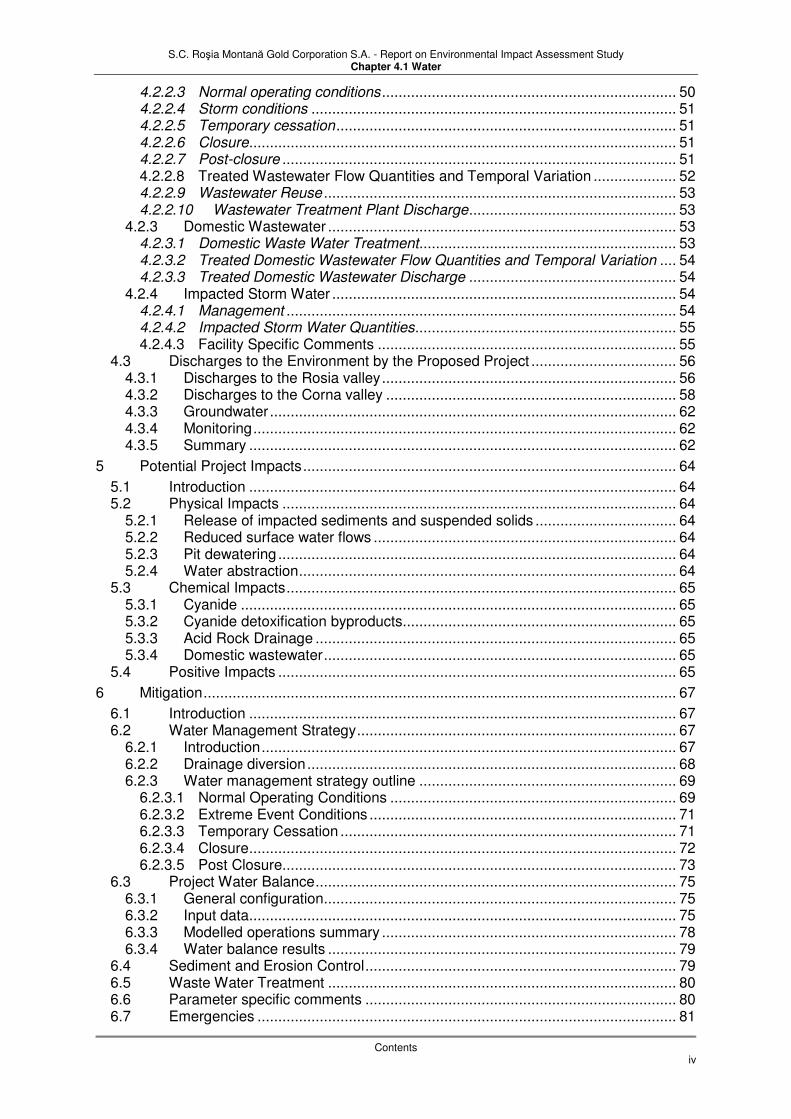
and runoff from open pit mining. The larger and more prominent of these features are shown on Exhibit 4.1.4, Existing Waste Rock Stockpiles. Both the larger waste rock accumulations associated with the more recent mining operations shown on Exhibit 4.1.4, and numerous smaller accumulations left over from the mining dating back more than a thousand years, contribute to the pollutant loading in the valleys. Figure 4.1.1. Regional Hydrology with Project Location
2.1 Meteorology
2.1.1 Sources of data Baseline meteorological data presented in this section focus on the occurrence and fate of precipitation. The data originate mostly from the INMH (Instiutul National de Meteorologie)a, and were generated by the stations at Rosia Montana (Rotunda) about 1 km north-east from the Project; the Roşia Montană Project meteorological station; and the Abrud Meteorological Station, located at the city of Abrud. Locations of these meteorological stations are shown on Exhibit 4.1.3. Additional meteorological information including data on temperature, humidity, nebulosity and wind are contained in Chapter 4.2 of this report addressing air baseline conditions. Table 4.1-1 gives characteristics of these stations.

S.C. Roşia Montană Gold Corporation S.A. - Report on Environmental Impact Assessment Study Chapter 4.1 Water
Section 2: Baseline Information
Page 12 of 96
Table 4.1-1. Schedule of meteorological stations
Station name Longitude Latitude Altitude Data collected
Rotunda (INMH Roşia Montana station)
356831 m E UTM (23º 08’ 30” E)
537002 m N UTM (46º 19’ 03” N)
1,198 m ASL Precipitation, evaporation, humidity, temperature, sunshine, wind speed, wind direction, snow depth (all since 1983)
Roşia Montana Project meteorological station
353797 m E UTM (23º 06’ 12” E)
534850 m N UTM (46º 17’ 27” N)
800 m ASL daily precipitation, evaporation, humidity, temperature, wind speed, wind direction, snow depth (all since March 2001)
Abrud (INMH rainfall and gauging station)
350816 m E UTM (23º59’ 00” E)
532198 m N UTM (46º 17’ 00” N)
599 m ASL River flow since 1965, precipitation since 1978
Câmpeni meteorological station
349327 m E UTM (23º 03’ 00” E)
542145 m N UTM (46º 22’ 00” N)
588 m ASL Precipitation only, since 1975
For the purpose of the water baseline characterisation, typical or average baseline meteorological conditions are presented, as well as information on extreme conditions. Specifically, extreme precipitation conditions have been evaluated, because the understanding of these conditions is critical for design of many of the Project facilities. 2.1.2 General climate conditions The climate of the region is classified as temperate continental with topographic influences.
Mean annual temperature is 5.4°C, with maximum and minimum monthly averages of
24.7°C (summer) and – 8.2°C (winter), respectively. The relative air humidity is approximately 77 percent for the entire period, with the most humid records in September 1996 (92%) and December 1988 (93%). The lowest relative air humidity was recorded in August (72%). The distribution of total nebulosity shows direct correlation to the air humidity. The multi-annual average frequencies of wind directions indicate southwest as the main direction (frequency 30.2%), followed by northeast and west. The approximate southwest-northeast orientation of Roşia Valley is of determinative importance in the creation of the predominant wind direction. The average wind speed per direction show values between 1.4 – 4.8 m/s. 2.1.3 Precipitation Precipitation is in the form of rainfall for most of the year, with snowfall occurring during several winter months. Average, maximum and minimum monthly precipitation data are shown in Table 4.1-2 and Figures 4.1.2, 4.1.3 and 4.1.4 for Rosia Montana (INMH Rotunda and Project stations) and Abrud. Full monthly data for the records available are also included in Appendix 4.1A. The peak rainfall typically occurs in summer, with the highest monthly average in June or July. For Rotunda and Abrud the highest monthly averages are 91.8 mm (July) and 106.4 mm (June) respectively. The highest for the Project station (150.5 mm in June) is biased by the wetter conditions over the last five years. The maximum monthly rainfall figures for the three stations over the period of record are 230.9 mm (July 2005) at Rotunda, 168.1 mm (July 2005) at the Project station, and 232.4 mm (December 1981) at Abrud. These data illustrate the short-distance spatial variability of precipitation events and that extreme falls can occur in summer or winter. The difference between the RMGC Project station in Roşia Montana and the INMH Rotunda station is mainly a function of altitude (the latter is over 300 m higher) and topography. Figure 4.1.5 shows how the monthly peak values at Rotunda generally exceed those at the Project station.

S.C. Roşia Montană Gold Corporation S.A. - Report on Environmental Impact Assessment Study Chapter 4.1 Water
Section 2: Baseline Information
Page 13 of 96
Compared to the summer months, precipitation values in winter are lower, with averages generally of 30-50 mm (although Abrud averages nearly 80 mm for December). A significant portion of winter precipitation is in the form of snow, with snowfalls recorded from October to March. Typically, snow remains on ground from December to March, with the main thaw usually occurring in March. In extreme situations, snowfall can occur as early as September and remain on the ground till mid May (see Figure 4.1.6). Table 4.1-2 also shows the monthly data for 2005, which was noted for heavy rain in the summer. The annual total for 2005 however, whilst high, was not the highest in the available record.
Table 4.1-2. Precipitation (mm) for Rosia Montana and Abrud
Station Year Jan Feb Mar Apr May Jun Jul Aug Sep Oct Nov Dec
Average 1983-2005
739.0 40.0 33.1 41.2 62.2 81.6 89.5 91.8 86.9 72.7 44.5 41.4 54.1
2005 1040.3 46.5 51.9 75.2 111.3 89.1 65.5 230.9 130.6 71.6 21.5 51.1 95.1
Maximum 1983-2005
1056.9 96.4 76.3 157.0 119.7 150.2 180.3 230.9 203.5 143.2 116.0 73.4 146.1
Rosia Montana (INMH Rotunda)
Minimum 1983-2005
563.7 7.0 6.1 7.3 16.7 25.3 19.2 21.1 26.2 9.8 3.0 7.2 12.2
Average 2001-2005
751.0 41.0 26.9 35.6 65.3 59.0 76.6 150.5 106.2 81.2 56.6 44.4 39.4
2005 786.9 17.7 25.3 65.2 103.8 73.5 83.4 168.1 94.6 69.5 13.9 20.9 51.0
Maximum 2001-2005
841.8 72.8 53.4 65.2 103.8 73.5 114.6 168.1 146.9 131.2 145.3 61.4 54.2
Rosia Montana (RMGC Project station)
Minimum 2001-2005
633.5 12.3 8.3 14.3 29.0 39.5 46.4 106.8 13.8 40.9 13.9 20.9 25.8
Average 1978-1999
806.5 51.6 44.4 46.7 66.5 88.3 106.4 84.0 74.3 68.5 49.7 46.3 79.8
Maximum 1978-1999
996.3 132.3 143.6 146.8 97.3 169.0 187.9 181.7 176.3 176.3 150.6 97.3 232.4 Abrud
Minimum 1978-1999
573.6 7.4 4.8 15.2 25.2 27.1 52.2 18.3 26.7 7.4 4.3 2.7 18.1
Source of data: INMH and RMGC Average total annual precipitation for the 23-year period of record from 1983 to 2005 is 739.0 mm for the INMH Roşia Montană Rotunda Station, ranging between 563.7 mm (1992) and 1056.9 mm (2001). The average annual precipitation at the Abrud Station from 1978 to 1999 is slightly higher at 806.5 mm, ranging from 573.6 mm (1983) to 996.3 mm (1997). For its five years of record, the RMGC Project station averages 751.0 mm. Annual time series for the three stations is shown in Figure 4.1.7. Two sequences of wetter than average years can be distinguished, i.e. 1978-1981 and 1995-1999. From 1982 to 1994 rainfall annual totals were generally below or around the average. Since 1999 annual totals have ranged across a similar amplitude to the whole range of the previous years in the record.

S.C. Roşia Montană Gold Corporation S.A. - Report on Environmental Impact Assessment Study Chapter 4.1 Water
Section 2: Baseline Information
Page 14 of 96
Figure 4.1.2. Rosia Montana monthly precipitation, 1983-2005
0
50
100
150
200
250
Jan Feb Mar Apr May Jun Jul Aug Sep Oct Nov Dec
Pre
cip
itati
on
, m
mRecord maximum Record minimum Record average
Figure 4.1.3. Rosia Montana (RMGC station) monthly precipitation, 2001-2005
0
50
100
150
200
250
Jan Feb Mar Apr May Jun Jul Aug Sep Oct Nov Dec
Pre
cip
itati
on
, m
m
Record maximum Record minimum Record average

S.C. Roşia Montană Gold Corporation S.A. - Report on Environmental Impact Assessment Study Chapter 4.1 Water
Section 2: Baseline Information
Page 15 of 96
Figure 4.1.4. Abrud monthly precipitation, 1978-1999
0
50
100
150
200
250
Jan Feb Mar Apr May Jun Jul Aug Sep Oct Nov Dec
Pre
cip
itati
on
, m
mRecord maximum Record minimum Record average
Figure 4.1.5. Correlation between INMH and RMGC stations monthly precipitation 2001-2005
0
50
100
150
200
250
Jan-
01
Mar
-01
May
-01
Jul-0
1
Sep-0
1
Nov
-01
Jan-
02
Mar
-02
May
-02
Jul-0
2
Sep-0
2
Nov
-02
Jan-
03
Mar
-03
May
-03
Jul-0
3
Sep-0
3
Nov
-03
Jan-
04
Mar
-04
May
-04
Jul-0
4
Sep-0
4
Nov
-04
Jan-
05
Mar
-05
May
-05
Jul-0
5
Sep-0
5
Nov
-05
Pre
cip
tati
on
, m
m
RMGC INMH

S.C. Roşia Montană Gold Corporation S.A. - Report on Environmental Impact Assessment Study Chapter 4.1 Water
Section 2: Baseline Information
Page 16 of 96
Figure 4.1.6. Monthly snow layer depth (cm)
Figure 4.1.7. Rosia Montana annual rainfall series
0
200
400
600
800
1000
1200
1978 1979 1980 1981 1982 1983 1984 1985 1986 1987 1988 1989 1990 1991 1992 1993 1994 1995 1996 1997 1998 1999 2000 2001 2002 2003 2004 2005
Pre
cip
itati
on
, m
m
INMH RMGC Abrud
0
10
20
30
40
50
60
70
July
Augus
t
Septe
mbe
r
Octob
er
Nov
embe
r
Dec
embe
r
Janu
ary
Febru
ary
Mar
chApr
ilM
ay
June
Maxinim
Minimum
AVERAGE

S.C. Roşia Montană Gold Corporation S.A. - Report on Environmental Impact Assessment Study Chapter 4.1 Water
Section 2: Baseline Information
Page 17 of 96
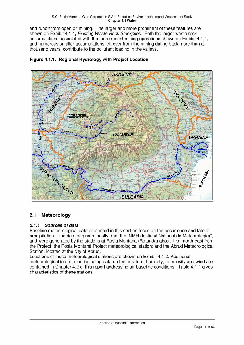
2.1.4 Extreme events For the purposes of establishing runoff volumes, estimates of extreme 24-hour storm rainfall events and Probable Maximum Precipitation (PMP) events have been developed. Two preliminary studies were carried out to evaluate historical 24-hour extreme rainfall events from the records of two regional climate stations at Abrud and Roşia Montană. However, due to the critical nature of this information to the design and operation of the Project, in 2004 RMGC commissioned an additional independent study by Professor Drobot to reassess the previous estimates. The resulting data are presented in the report on Assessment of Rainfall Intensity, Frequency and Runoff for Roşia Montană Project (Baseline Reports, Report 2). This study includes a spatial distribution assessment of extreme historical precipitation in Romania, and data collection and statistical analysis of the record from 21 meteorological stations located in a 60-km radius around Roşia Montană. Based on statistical analysis of the 21 stations over a common 16-year period, 10 stations were selected as representative for the Roşia Montană site, and a full record was obtained and analysed for those stations. The most significant recorded rainfall event was a 262 mm, 24-hour precipitation event in Deva in July 1936. This event occurred only 50 km south of Roşia Montană. The analysis was conducted for two distinct periods: summer from May to November and winter from December to April. The winter precipitation values were combined with the maximum snowmelt value calculated using a day-degree method. By analysing the snow cover at Roşia Montană, snow density and recorded temperatures, it was found that March and February are the critical snowmelt months. The primary findings of the study are summarised in Table 4.1-3.
Table 4.1-3. Extreme Precipitation Events for Roşia Montană Area
Assessment of Rainfall Intensity, Frequency and Runoff for Roşia Montană Project
Return Period of
Event (Years)
Probability of Exceedance In 17 Years 24-hour Summer Rainfall
24-hour Winter Rainfall + Snowmelt
100 15.7% 112 122
500 3.3% 146 147
1,000 1.7% 161 158
10,000 0.2% 211 191
100,000 --- --- ---
PMP --- 450 440
Note: Rainfall depths are given in millimetres (mm).
Source: Drobot, 2004 (Baseline Reports,Report 2). From these data it is observed that the summer extreme precipitation event is higher than winter, with summer rainfalls very similar to winter rainfalls combined with extreme snowmelt. In addition to the PMP event, the amounts associated with other return intervals were reassessed. While the findings of the 2004 study indicated a PMP considerably higher that what had previously been used for the area, the other design storm events were similar to previous estimates. Figures 4.1.8 and 4.1.9 show the 24-hour events graphically and emphasise how conservative the PMP is as a design criterion (and the TMF is designed to store two successive PMP events). The range of annual peak 24-hour rainfall events (Figure 4.1.9) is quite narrow (generally around 40-50 mm) and so the slope of the line in Figure 4.1.8 is fairly shallow. Extrapolation of this line places the estimated PMP at a return period equivalent to 1,000,000,000 years, although this is of low significance compared with the statistical analysis of actual Romanian rainfall records carried out by Prof. Drobot, especially given that the 1:10,000 year event (211 mm for summer rainfall), which is commonly used for PMP estimation in the absence of other data, was exceeded by the actual event in Deva in 1936. Another commonly-used approximation is three times the 1:200-year event, which is similar to the Drobot estimate.
S.C. Roşia Montană Gold Corporation S.A. - Report on Environmental Impact Assessment Study Chapter 4.1 Water
Section 2: Baseline Information
Page 18 of 96
Figure 4.1.8. Rosia Montana 24 hour extreme events
0
50
100
150
200
250
300
350
400
450
500
10 100 1,000 10,000 100,000 1,000,000 10,000,000 100,000,000 1,000,000,000
Return period, years (log scale)
24 h
ou
r p
rec
ipit
ati
on
, m
m
PMP
Figure 4.1.9. Rosia Montana precipitation, 24 hour maxima (actual and design extreme events)
0
50
100
150
200
250
300
350
400
450
500
1978
1979
1980
1981
1982
1983
1984
1985
1986
1987
1988
1989
1990
1991
1992
1993
1994
1995
1996
1997
1998
1999
2000
2001
2002
2003
2004
2005
Pre
cip
itati
on
, m
m
Rosia Montana
RMGC
Abrud
100 years
1000 years
10000 years
PMP
Runoff coefficients are also evaluated in the report on Assessment of Rainfall Intensity, Frequency and Runoff for Roşia Montană Project (Baseline Reports, Report 2) in order to address the Probable Maximum Flood (PMF) events. Runoff coefficients for small basins vary generally from 35 to 80 percent and are a function of basin slope, forest cover, soil texture and Anterior Precipitation Index (API). The latter represents a measure of soil humidity resulting from previous precipitation. The winter PMP runoff could theoretically occur immediately after or concurrently with significant snowmelt, in which case a high API

S.C. Roşia Montană Gold Corporation S.A. - Report on Environmental Impact Assessment Study Chapter 4.1 Water
Section 2: Baseline Information
Page 19 of 96
would occur. For that reason, a winter PMP runoff coefficient of 90 percent was proposed. A higher winter runoff coefficient could also be expected in situations of frozen ground and frozen snow cover, but it would not be justifiable to combine this PMP scenario with the maximum snowmelt. As for the summer PMP, a maximum runoff coefficient of 80 percent is considered reasonable. In both cases, a 100 percent runoff coefficient should be used for water surfaces and over relatively impervious areas. Maximum runoff coefficients for other (non-PMP) design events were also assessed in the study, and range from 30 to 40 percent for the 10-year return period, 35 to 60 percent for the 100-year period, and 50 to 70 percent for the 1,000-year or high return period. The limits of the ranges correspond to the shortest and longest rainfall duration, respectively. 2.1.5 Evaporation Evaporation data appropriate to the Project site facilities and conditions (developed from an INMH study in 2002) are presented in Table 4.1-4.
Table 4.1-4. Monthly evaporation (mm) for Rosia Montana
Year Jan Feb Mar Apr May Jun Jul Aug Sep Oct Nov Dec
Average 469.5 0.0 0.0 0.0 55.0 68.2 74.0 71.3 89.5 68.1 43.4 0.0 0.0
High 704.4 0.0 0.0 0.0 82.5 102.3 111.0 107.0 134.3 102.2 65.1 0.0 0.0 Low 372.3 0.0 0.0 0.0 33.0 80.6 55.7 57.6 59.3 45.8 40.3 0.0 0.0
Source of data: INMH (2002) 2.1.6 Climate change It is necessary to address the potential predicted changes in climate during and after the operational phase of the project so that designs can be updated if necessary and the water balance performance of the Project can be continually reviewed. Appendix 4.1B analyses the likely climate changes to affect the Project area based on current knowledge, and this is summarised below. Predicted changes compare the 1961-1990 period as a baseline, referenced forward 110 years to the period 2071-2100. The Rosia Montana project (operational, closure and early post-closure phase) falls approximately 25-50% through that interval; later post-closure phases are >50% through that interval. General climatic changes between 1961-1990 and 2071-2100 are predicted as:
� Temperature increases of up to 6 degC with respect to annual mean and in winter
� Temperature increases of up to 9 degC in summer
� Winter rainfall increases of 10-30%
� Summer rainfall decreases of 20-60%
� Possible increases of maximum annual daily rainfall by up to 30% (with a corresponding increase in extreme 24-hour events)
� Reductions in snow fraction of precipitation by 10-40 percentage points
To assess the potential impact of these predictions, the rainfall record can be reviewed in the context of an average rainfall adjusted for climate change predictions. For this purpose it is assumed that the predictions for 2071-2100 are halved in magnitude since the project main activity takes place at the end of the first half of the timespan between climate change baseline and prediction period. In other words, the predicted ‘normal’ conditions relevant to the project are assumed to be:
� Winter precipitation (December-February) - increase by 5-15% (50% of mean predicted increase to 2071-2100)
� Spring precipitation (March-May) - no change

S.C. Roşia Montană Gold Corporation S.A. - Report on Environmental Impact Assessment Study Chapter 4.1 Water
Section 2: Baseline Information
Page 20 of 96
� Summer precipitation (June-August) - decrease by 10-30% (50% of mean predicted decrease to 2071-2100)
� Autumn precipitation (September-November) - decrease by 5%
� Extreme events increase in magnitude by 0-15% (50% of predicted increase of up to 30%)
With respect to snow fraction of precipitation, there are no data on the current situation. However, it would seem reasonable to assume from the predicted increases in winter temperature that more precipitation will occur as rain in the winter months, and that snowmelt will peak earlier.
2.2 Surface Water
Surface water in the Project area is characterised by relatively small streams that flow into larger rivers downstream of the Project. There are also a few small man-made lakes in the vicinity of the Project area which are associated with historical mining activities. The physical and chemical characteristics of the streams, rivers and lakes, are described in this section. 2.2.1 General drainage description The Arieş River is the most important water resource in the Apuseni Mountains in the territory of Alba County, with three-quarters of its drainage located within the area and with a length of 164 km. The Arieş River passes some 10 km north of the Roşia Montană area, collecting water from the Abrud and Câmpeni tributaries, as well as from numerous smaller local valleys (e.g. Stefancii). Consequently, the Arieş is a major river with considerable flow variation and the most significant potential source of freshwater in the vicinity of the proposed Roşia Montană Project. The Abrud River originates at springs near Detunata Ridge and is approximately 32.5 km long. Elevations near Detunata Peak are around 961 m and decrease downstream to about 540 m, where the Abrud River flows into the Arieş River. Streams radiate from the highest ridges in the Project area, which are concentrated to the east of the proposed Project and flow west and north into the Abrud and Arieş Rivers, respectively (see Exhibit 4.1.3). The village of Roşia Montană is bisected by the west-flowing Roşia Stream, which drains east-west trending linear ridges. The southern ridgeline also drains west and southwest into the adjacent Salistei and Corna Valleys, respectively. The ridgeline to the northeast is dominated by Rotund Hill (1,191 m), which is the western-most of the higher ridges and peaks to the east of the Project area. The channels of all these mountain streams are irregular with a pronounced “V” shape with streambeds composed of alluvial deposits. 2.2.2 Surface Water Flows A synopsis of the stream flow data from 2001 to 2004 for the four streams flowing through Project area or in the vicinity of the Project area (Exhibit 4.1.3) is presented in Table 4.1-5, Summary of Stream Flows in the Area. Hydrographs for the period are shown, together with rainfall data for the Rosia Montana meteorological station in Exhibit 4.1.5, Summary flows. The data were collected from weirs with automated gauging equipment, in accordance with the requirements of the current RMGC water monitoring programme. Data collection was based on four automatic readings per hour. The readings were transferred from the data log to a worksheet and then downloaded into a dedicated database. The weirs were designed and installed in accordance with the ISO 8368 (1999) requirements and are monitored and maintained on a regular basis. Key data concerning the Abrud River catchment is presented in Table 4.1-6, Abrud Hydrological Data (at Abrud) with data concerning the Arieş River at Câmpeni in Table 4.1-7, Arieş Hydrological Data (at Câmpeni). These data were obtained from the INHM flow monitoring stations in Abrud and Câmpeni, respectively for the recording period up to 2000.

S.C. Roşia Montană Gold Corporation S.A. - Report on Environmental Impact Assessment Study Chapter 4.1 Water
Section 2: Baseline Information
Page 21 of 96
The drainage system is shown schematically in Exhibit 4.1.6, Surface Water Flows with average, maximum and minimum daily flows at the measuring locations. Although monitoring is not for the same period, a rough comparison of average daily flows is possible. As a percentage of the Arieş flow at Câmpeni, the stream flows are as follows; Abrud at Abrud (11.4%), Rosia (1.4%), Salistei (0.9%), Corna (1.1%) and Abruzel (1.1%). Stefanca Valley has an area of 1,128 ha, and drains northward. The stream flows directly into the Arieş River, much further downstream than the other four valleys. There are two tailings impoundment lakes in the valley, associated with the Roşia Poieni mining operation. However, as there was no plan to utilise this valley for the proposed mining operation, no inventory of water points was carried out for the Project in the valley. An abandoned right-angled weir exists in the valley stream. The design of the weir is such that it is unsuitable for measurement of low flows. Water discharging from the underground mine features contribute to the surface water flows in the Abruzel, Roşia and Corna Valleys. Roşia Montană has the highest flow from adits. Two major mine adit outflows contribute to the Roşia stream flow, the main drainage exit from the existing mine workings being at 714 metres above sea level (testing point R085 or Adit 714). Recent observations of the 714 Adit outflow in the Roşia Valley indicate that the flow varies from approximately 39.6 to 63.0 m3/hr (11.0 – 17.5 L/s) on a monthly average basis. Based on this, the estimated average annual flow rate is 51.1 m3/hr (14.2 L/s). About 8 % of the average Roşia Valley flow is from the 714 adit. The Corna valley also has significant mine outflow (16.2 m3/hr, 4.5 L/s) from two sources that are close to each other and appear to be springs. Because of the iron-stained appearance of the water, its low pH, and the proximity of the sources to the existing mine workings, the flow is assumed to originate from collapsed mine adits. The Salistei valley’s significantly higher runoff can be attributed to the inflow of tailings into this relatively small catchment from the existing Roşiamin operation. Exhibit 4.1.5, Summary flows demonstrates the rapid response of the surface water flows to precipitation events. The shale that dominates the geology over a significant proportion of the area around the project results in low permeability soils, reducing the infiltration of precipitation. Similarly, the volcanic rocks of the project area also exhibit low permeability. As a result a large portion of the precipitation from high intensity storms reports as surface water runoff. The lack of large lakes in the valleys further limits storm water retention in the catchments. Rapid responses to precipitation events have also been observed in mine adit flows, suggesting that direct conduits for rainfall infiltration into and out of the underground mine network are present. The mine network should therefore probably be conceptualised as an underground extension to the surface water system rather than as a groundwater system. A comparison of stream flow and precipitation data (Exhibit 4.1.5, Summary flows) also indicates that larger flood events occur after a sequence of precipitation events rather than after a single large precipitation event. This suggests that there is some temporary storage available before field capacity is reached. Some analyses of flow data have been carried out. INMH, 2002 calculated the maximum flow rates of 100 and 58.3 m3/s exceeding the probabilities of 0.1% and 1% respectively for the Roşia Stream (in other words, the Roşia Stream flow would be expected to be less than 100 m3/s 99.9% of the time, and less than 58.3 m3/s 99% of the time). For the Sileste maximum flow rates of 5.9, 4.85 and 3.8 m3/s exceeding the probabilities of 0.5%, 1% and 5% respectively were calculated. The flow calculations were based on empirical catchment characteristics. A low flow analysis based on the measured historical flow record for the Arieş at Cimpeni and extraplolated to Girde is presented in Knight Piesold 2002.
S.C. Roşia Montană Gold Corporation S.A. - Report on Environmental Impact Assessment Study Chapter 4.1 Water
Section 2: Baseline Information
Page 22 of 96
Table 4.1-5. Summary of Stream Flows in the Area
Roşia Valley Weir (Catchment Area = 14.7 km2)
Flow (m3/hr) Specific discharge
(m3/hr/km2)
Period Minimum Maximum Average Maximum Average
Instantaneous 26.43 11,664.3 551.8 739.4 37.5
Daily 41.3 7,862.9 625.2 534.9 42.5
Monthly 60.3 1,595.8 530.3 108.5 36.0
Corna Valley Weir (Catchment Area = 9.7 km2)
Flow (m3/hr) Specific discharge
(m3/hr/km2)
Period Minimum Maximum Average Maximum Average
Instantaneous 14.6 8,565.4 416.3 883.0 42.9
Daily 59.5 5,909.7 487.4 609.2 50.2
Monthly 197.7 1,307.0 528.2 134.7 54.4
Salistei Valley Weir (Catchment Area = 4.5 km2)
Flow (m3/hr) Specific discharge
(m3/hr/km2)
Period Minimum Maximum Average Maximum Average
Instantaneous 6.4 5,624.6 419.2 1,249.9 93.1
Daily 66.1 2,649.2 427.4 588.7 94.9
Monthly 201.8 1,170.2 451.8 260.0 100.4
Abruzel Valley Weir (Catchment Area = 13.9 km2)
Flow (m3/hr) Specific discharge
(m3/hr/km2)
Period Minimum Maximum Average Maximum Average
Instantaneous 4.06 16,238.6 487.3 1,168.2 35.0
Daily 6.39 7,142.2 458.5 513.8 32.9
Monthly 33.62 1,664.5 516.0 119.7 37.1
Source: RMGC Database, data through 2005
Table 4.1-6. Abrud Hydrological Data (at Abrud)
Statistic for Abrud Value Units
Area of Abrud gauging station catchment: 109 km2
Average daily flow at Abrud (1965 to 2000) 5,177 m3/hr
Minimum recorded flows at Abrud (1965 to 2000):
02.02.91 209 m3/hr
19.12.73 216 m3/hr
23.08.93 216 m3/hr
31.08.92 238 m3/hr
15.11.83 241 m3/hr
16.01.84 241 m3/hr
13.12.86 241 m3/hr
09.07.68 259 m3/hr
Maximum recorded flows at Abrud (1965 to 2000):
10.03.00 223,000 m3/hr
06.04.00 220,000 m3/hr
31.03.86 220,000 m3/hr
27.12.95 187,000 m3/hr
31.07.80 151,000 m3/hr
Average daily specific discharge at Abrud (1965 to 2000) 46.8 m3/hr/km
2

S.C. Roşia Montană Gold Corporation S.A. - Report on Environmental Impact Assessment Study Chapter 4.1 Water
Section 2: Baseline Information
Page 23 of 96
Table 4.1-7. Arieş Hydrological Data (at Câmpeni)
Statistic at Câmpeni Value Units
Area of Câmpeni gauging station catchment: 615 km2
Average daily flow at Câmpeni: (1975 to 2000) 45,300 m3/hr
Minimum of low flow periods at Câmpeni (1975 to 2000):
11.12.86 2,860 m3/hr
15.12.83 3,380 m3/hr
05.12.78 4,070 m3/hr
24.11.88 4,360 m3/hr
15.02.84 4,990 m3/hr
Maximum of high flow periods at Câmpeni (1975 to 2000):
12.03.81 1,832,000 m3/s
27.12.95 1,289,000 m3/s
12.04.00 1,058,000 m3/s
10.03.00 659,000 m3/s
03.07.75 504,000 m3/s
Average specific runoff at Câmpeni: (1975 to 2000) 72.0 m3/hr/km
2
2.2.3 Surface Water Quality The Roşia Montană Project is located in the Roşia Montană mining district immediately northeast of the town of Abrud (see Exhibit 4.1.3). Mining has been carried out in this district since Roman times. The streams in the Roşia Montană Project area are characterised by poor water quality as a result of water emanating from old mines, drainage from mine waste and tailings, and other discharges from farms, dwellings, and industrial operations. The water quality of the man-made lakes also reflects the impact of past activities in the Project area, and the historical record indicates that pollution of streams and rivers from the mines in the area was notable since at least medieval times. Table 4.1-8, Surface Water Quality in the Roşia Montană Area, provides an evaluation of the characterisation of the water quality in the local streams and springs based on the criteria proposed in Ministry Order 1146/2003. The evaluation is based on the results of the monitoring program presented in the Water Baseline Report (Baseline Report, Report 1, Part 1). The table provides a general indication of the current level of pollution in the various stream reaches, but does not represent any sort of regulatory prescription and should not be interpreted as such. However, it does provide a reference point in comparison between baseline conditions and potential impacts. The classification shown in Table 4.1-8 ranges from Class I (natural reference conditions) to Class V (degraded). The sampling points in relation to the proposed project development are shown in Exhibit 6.1 in Chapter 6.

S.C. Roşia Montană Gold Corporation S.A. - Report on Environmental Impact Assessment Study Chapter 4.1 Water
Section 2: Baseline Information
Page 24 of 96
Table 4.1-8. Surface Water Quality in the Roşia Montană Area
M.O. 1146 Surface Water Categorisation No.
Sampling Point
Watercourse
I II III IV V
1 S17 BUCIUM (Alba Valley) X
2 S18 SESII Buciumani X
3 S19 BUCIUM VALEY before Izbicioara Valley X
4 S20 IZBICIOARA X 5 S01 ABRUD X
6 S21 MUNTARI Abruzel from Roşia Poieni Rock Dump X 7 S22 PETRENI Abruzel upper X 8 S02 ABRUZEL before Abrud X
9 S03 ABRUD before Corna X 10 S32 Cirnicel (old mining waste dumps) X
11 S33 Cirnicel(after old mining waste dumps) X
12 S04 CORNA before Abrud X 13 S05 CERNITA before Abrud X
14 S06 ABRUD before Salistei Valley X 15 S07 SALISTE before Abrud X
16 S23 ABRUD before Gura Rosiei tailings dump X 17 S08 ABRUD before Roşia Valley X
18 S09 ROŞIA MONTANĂ after water overflow from crusher X 19 S10 ROŞIA MONTANĂ before Abrud River X
20 S11 ABRUD after Roşia Valley X
21 S12 ABRUD before Arieş River X 22 S13 ARIEŞ before Abrud River X
23 S14 ARIEŞ before Stefanca Valley X 24 S15 STEFANCA before Arieş X 25 S16 ARIEŞ after Stefanca Valley X
26 S24 SESEI VALLEY Lupsa before Arieş X 27 S25 SARTASUL tailings water outfall before Arieş X
28 S27 Arieş River at Lunca X 29 S26 Arieş River at Sartas X
30 S28 Mures at Alba Iulia X 31 S29 Top of RM Stream before Taul Mare X
32 S30 RM Stream after Taul Mare X
33 S31 RM Nanului Valley X
Notes: Stream reaches between 1 and 30 are generally shown from upstream to downstream of the Project.
The official classification by the National Administration of the “Apele Romana” for the 166 km of the Arieş River and 24 km of the Abrud River is presented in Table 4.1-9, Surface Water Conditions in the Abrud and Arieş Rivers. Reportedly the 1146/2003 legislation is currently being evaluated as the method for surface water quality classification in Romania, so both are presented in Table 4.1-9.

S.C. Roşia Montană Gold Corporation S.A. - Report on Environmental Impact Assessment Study Chapter 4.1 Water
Section 2: Baseline Information
Page 25 of 96
Table 4.1-9. Surface Water Conditions in the Abrud and Arieş Rivers
Category of the Water Quality as Classified by the National Administration of the “Apele Române” Section
I II III IV (D) V
Reference Legislation
Abrud River(24km):
24km 1146/2003
Entire length of the river
24km 4706/88
Arieş River (166km):
40km 1146/2003 Section A. Spring to confluence with
Little Arieş (40km) 40km 4706/88
9km 1146/2003 Section B.
From confluence with Little Arieş to confluence with
Abrud (9km) 9km 4706/88
58km 1146/2003 Section C. From confluence with Abrud to Bistra and Ocolisel (58km) 58km 4706/88
STAS 4706/88 Classifications*: Category I – Includes waters that can become drinkable to supply the centres of population or animal breeding units, the food industry, salmonid farms and bathing resorts (pools). Category II – Includes surface waters that can be used for industry, pisciculture (for fish that all not as sensitive to pollution as trout), and for urban and recreational use. Category III – Includes waters for irrigating agricultural land, electric power production in hydroelectric power plants, industrial cooling installations, cleaning units and other purposes. Category IV(D) – Includes degraded water improper for the development of aquatic fauna. Reference: Letter from National Administration of the “Apele Romana” dated September 9, 2003. * Note: STAS 4706-88 now replaced by MO1146/2003
Abstraction for the project will be from Section B of the Arieş and discharge will be to the Abrud. The National Administration of the “Apele Romana” classifies the whole 24 km of Abrud River length as category IV [D] under 4706/88 legislation and Category V water under the 1146/2003 legislation. Surface water within the local valleys including the entire length of the Abrud is polluted to the point that it is not capable of supporting fish. As noted in Section “Monitoring”, and elsewhere in this EIA, RMGC has implemented a water sampling and monitoring program since November 2000, and routinely evaluates surface and groundwater quality in the Project area. Thirty-eight surface water sampling points (Exhibit 6.1) within the project concession and neighbouring streams and rivers are routinely sampled for various chemical parameters. Recent results of the sampling program are summarised below and in Exhibits 4.1.7 and 4.1.8, Surface Water Quality - Key Parameters. The sampling is described and the results are discussed in the Water Baseline Report. (Baseline Report, Report 1) and are summarised below. The report also identifies the list of parameters considered in the evaluation, which was based on comparisons of Romanian legislation, guidance, and parameters identified as potential hazards to human health in the Roşia Montană area. Although an extensive suite was analysed in the baseline study, specific key parameters found to frequently exceed limits prescribed by Romanian legislation were given particular scrutiny in the study and include the followings:
� pH
� Arsenic
� Cadmium
� Chromium
S.C. Roşia Montană Gold Corporation S.A. - Report on Environmental Impact Assessment Study Chapter 4.1 Water
Section 2: Baseline Information
Page 26 of 96
� Copper
� Lead
� Nickel
� Selenium
� Sulphate
� Zinc.
Because of potential impacts by the project on surface waters, baseline levels of cyanide, calcium, sulphate and iron were also assessed. Exhibit 4.1.7 lists the average analyses for key hydrochemical parameters and Exhibit 4.1.8 the maxima. A summary of this data at key locations is shown schematically in Exhibit 4.1.9. Electrical conductivity and the sum of As, Cd, Cu and Ni are included as general indicators of water quality. Exceedances with respect to the discharge standard NTPA 001/2005 (TN001) are shown in red. Because of the tendency of the European Union Water Framework Directive (2000/60/EC, Clause 40) to consider discharge impacts using an approach combining concentrations in the discharge with concentrations in the receiver, exceedances with respect to the surface water standard MO1146 are shown in yellow, and the drinking water standard STAS 1342 is also included. Because the latter is generally the most stringent standard and the former the least, each box in the table is coloured according to the least stringent standard exceeded. The sample points are listed by catchment, and, within each catchment, in sequence from upstream to downstream. Some general observations can be drawn from the data: The concentration of hydrochemical parameters is largely determined by the stream flow (Figure 4.1.10), with concentrations decreasing as flow increases. However, it should be noted that there are many exceptions to this trend. This is probably due to a combination of insufficient samples being taken at any given location, the actual sampling time not being related to the flow measurement time and, in some instances, the sampling point not being the same as the flow measurement location. As a consequence, a reliable relationship between flow and concentration cannot be demonstrated conclusively. In most instances, the averages given in Exhibits 4.1.7 and 4.1.9 are for 13 sampling occasions during 2000 to 2005. These occasions are reasonably spread over the annual hydrological cycle. Because regular, more frequent sampling was not conducted, maxima are also presented (Exhibit 4.1.8). More frequent sampling would have permitted the calculation of more reliable average concentrations of hydrochemical parameters. During mine operation and closure it is recommended that monthly sampling is carried out at the flow measurement locations and the time of sampling recorded. Exhibits 4.1.7 and 4.1.9 show that the River Abrud is polluted before the confluence with the Corna stream. Mining activities upstream, particularly in the Bucium (Alba valley) and especially the Muntari headwater of the Abruzel are the sources of pollution. Some dilution by other tributaries improves the quality of the Abrud, although the average pH is already more acidic than the TN001 discharge standard prior to joining the Corna stream.
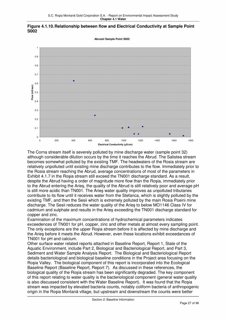
S.C. Roşia Montană Gold Corporation S.A. - Report on Environmental Impact Assessment Study Chapter 4.1 Water
Section 2: Baseline Information
Page 27 of 96
Figure 4.1.10. Relationship between flow and Electrical Conductivity at Sample Point S002
Abruzel Sample Point S002
0
0.1
0.2
0.3
0.4
0.5
0.6
0.7
0.8
0.9
1
0 200 400 600 800 1000 1200 1400 1600 1800
Electrical Conductivity (µS/cm)
Flo
w (
m3
/se
c)
The Corna stream itself is severely polluted by mine discharge water (sample point 32) although considerable dilution occurs by the time it reaches the Abrud. The Salistea stream becomes somewhat polluted by the existing TMF. The headwaters of the Rosia stream are relatively unpolluted until existing mine discharge contributes to the flow. Immediately prior to the Rosia stream reaching the Abrud, average concentrations of most of the parameters in Exhibit 4.1.7 in the Roşia stream still exceed the TN001 discharge standard. As a result, despite the Abrud having a order of magnitude more flow than the Roşia, immediately prior to the Abrud entering the Arieş, the quality of the Abrud is still relatively poor and average pH is still more acidic than TN001. The Arieş water quality improves as unpolluted tributaries contribute to its flow until it receives water from the Stefanca, which is slightly polluted by the existing TMF, and then the Sesii which is extremely polluted by the main Rosia Poeini mine discharge. The Sesii reduces the water quality of the Arieş to below MO1146 Class IV for cadmium and sulphate and results in the Arieş exceeding the TN001 discharge standard for copper and zinc. Examination of the maximum concentrations of hydrochemical parameters indicates exceedences of TN001 for pH, copper, zinc and other metals at almost every sampling point. The only exceptions are the upper Roşia stream before it is affected by mine discharge and the Arieş before it meets the Abrud. However, even these locations exhibit exceedances of TN001 for pH and calcium. Other surface water related reports attached in Baseline Report, Report 1, State of the Aquatic Environment, include Part 2, Biological and Bacteriological Report, and Part 3, Sediment and Water Sample Analysis Report. The Biological and Bacteriological Report details bacteriological and biological baseline conditions in the Project area focusing on the Roşia Valley. The biological component of this report is incorporated into the Ecological Baseline Report (Baseline Report, Report 7). As discussed in these references, the biological quality of the Roşia stream has been significantly degraded. The key component of this report relating to water quality is the bacteriological component (general water quality is also discussed consistent with the Water Baseline Report). It was found that the Roşia stream was impacted by elevated bacteria counts, notably coliform bacteria of anthropogenic origin in the Roşia Montană village, but upstream and downstream the counts were better

S.C. Roşia Montană Gold Corporation S.A. - Report on Environmental Impact Assessment Study Chapter 4.1 Water
Section 2: Baseline Information
Page 28 of 96
than the standards. A limited assessment of drinking water from groundwater wells was also conducted in the village, with some bacteriological contamination identified. Sediment and Water Sample Analysis Report (Baseline Report, Report 1, Part 3) presents the results of a study conducted by “fluvio” (Institute of Geographic and Earth Science, University of Wales, UK). The focus of this study was the baseline identification and environmental assessment of the Roşia Montană geochemical “footprint” on the Abrud and Arieş watersheds. The evaluation suggests that the current impacts from the existing and historic mining in Roşia Montană extend to 24 to 30 km downstream of the Roşia Stream – Abrud River confluence in the Arieş River. This analysis was based on water quality, sediment quality with “fingerprinting” techniques. 2.2.4 Lakes The lakes in the area were mainly built in the 19th century as water storage ponds for gold mining activities and are typically located in upland areas. The largest lakes are:
� Taul Mare near the head of the Roşia Valley (Area = 32,120 m2, Volume = 160,600 m3, Maximum Depth = 10m)
� Taul Tarinii on the north flank of the upper Roşia Valley (Area = 10,480 m2, Volume = 27,300 m3, Maximum Depth = 4.5m)
� Taul Brazilor on the south flank of the upper Roşia Valley (Area = 7,800 m2, Volume = 22,000 m3, Maximum Depth = 5.5m)
� Taul Anghel on the south flank of the upper Roşia Valley (Area = 4,250 m2, Volume = 8,500 m3, Maximum Depth = 4.5m)
� Taul Corna in the Corna Valley headwater (Area = 8,830 m2, Volume = 15,930 m3, Maximum Depth = 3.6m)
All of these lakes were sampled as part of the baseline characterisation described in the State of the Aquatic Environment Report (Baseline Report, Report 1). In addition, Taul Cartuş and Taul Gauri in the Corna Valley, and Taul Tapului in the Roşia Valley were sampled and evaluated. The locations of the lake are shown on Exhibit 4.1.3, Surface Water Catchment Map and are detailed in Baseline Report, Report 1, Part 1. These man-made lakes are reportedly spring-fed. No outflow has been observed and there is no reported substantial water withdrawal. For this reason, they do not play a significant role in the hydrology and it is assumed that all spring inflow is balanced by evaporation and seepage. As noted in Water Baseline Report (Baseline Report, Report 1, Part 1), the water quality in the lakes is good, generally not exceeding water quality standards, with the exception of mercury and selenium. Substantial concentrations of mercury have been detected in the lake water up to greater than 10 times the relevant standard. Mercury is not commonly detected in other waters associated with the Project area, including flows from the mine workings. However, mercury was commonly used in the early gold processing. It is therefore likely that because the lakes were associated with 19th century gold mining, the mercury originates with this activity. The elevated mercury concentrations in the water column probably reflect elevated concentrations of methyl mercury in the water and mercury and methyl mercury in the pond sediments.
2.3 Groundwater
An independent baseline study was conducted in 2000 and 2001 that included 140 hand-dug wells, 175 springs and mine adit flows in the mine area and the four adjacent watersheds (i.e. the Abruzel, Corna, Salistei and Roşia Valleys). The purpose of the inventory was to add to the hydrological knowledge base of the area with the objective of assessing baseline catchment water balances, underground permeability, conductivity, the effect of springs on project design, the availability of groundwater resources, and initial estimates of dewatering requirements. Additional details of the hydrogeology of the Project area are summarised in

S.C. Roşia Montană Gold Corporation S.A. - Report on Environmental Impact Assessment Study Chapter 4.1 Water
Section 2: Baseline Information
Page 29 of 96
the Hydrogeology Baseline Report (Baseline Reports, Report 3). As noted therein, additional geotechnical testing at the site in 2003 and 2004 further expanded RMGC knowledge of the subsurface conditions. 2.3.1 Hydrogeology Potentially water-bearing rocks in the Project area include Jurassic – Cretaceous sedimentary rocks, the volcanic sequences, and the superficial deposits of alluvium and colluvium. The Jurassic – Cretaceous rocks found in the Project area include discontinuous sandstone and conglomerate beds that do not yield significant amounts of groundwater. The majority of the Cretaceous sediments, including thick sequences of shale, are of very low permeability. The volcanic dacite, vent breccia and black breccia also have very low primary permeability. What permeability is present in the sedimentary and volcanic sequences is due to secondary structural features such as fractures and faults. The unconsolidated superficial deposits and near-surface weathered rock can have significant water bearing capacity in places but are too thin to be exploited for large to medium water resource purposes, and are most suited for small domestic water supplies. Late post-mineralization Neogene age andesitic flows and pyroclastics, dominated by agglomerates, occur to the immediate north of Jig and east of Cârnic as well as remnant scree in the Orlea area on the north side of the Rosia Valley. These andesitic volcanic units are weakly porous and allow for some flow of ground water within the agglomerate units and out along the contact zones with what is generally underlying non-permeable Cretaceous age sediments. A number of springs and small lakes occur along this contact in areas away from the project. A discussion of each of the three potentially water-bearing units at the site (sedimentary rocks, volcanic rocks, and superficial deposits) is presented below: 2.3.1.1 Sedimentary Rocks The late Jurassic – Cretaceous sedimentary rocks comprise predominantly black shale
flysch deposits of low permeability (less than 1 × 10⁻⁵ cm/s, approximately 1 × 10⁻² m/d - note that this is not a velocity even it has the same dimensions/units) The youngest strata of the Abruzel unit is Maestrichtian in age and consists of interbedded sandstone, conglomerate and shale (termed micaceous gritty flysch and coarse-grained sandstones on local geologic maps). Deep geotechnical holes in Salistei Valley encountered interbedded sandstones and shales. The thickness of the sandstone and conglomerate beds ranges from a few millimetres to approximately one metre. The highly disturbed nature of the geology means these beds are discontinuous and encapsulated in the lower permeability shales. Consequently these strata do not have any significant water bearing capacity and do not warrant further water resource investigation. What water bearing capacity the sedimentary rocks have is largely secondary due to structural deformation and the presence of brecciated rocks associated with shear zones. It has also been observed that the shallow bedrock has higher relative permeability compared to deeper rock. This permeability is associated with the weathered horizon of the rock, but the lower lithostatic pressure near the surface may also allow fractures to open up. Most groundwater flow appears to occur in the weathered horizon near the contact with the overlying soil and colluvium. 2.3.1.2 Volcanic Rocks The volcanic units are extremely heterogeneous and anisotropic, so their hydrogeologic properties vary substantially over small distances. It is possible that primary permeability contributes a minor amount to the unit’s water bearing capacity. Where substantial water yield occurs within the units it is due mainly to secondary permeability. It is also possible in mined areas that acid mine drainage has further resulted in dissolution and subsequent permeability enhancement of calcareous zones in the breccia. Calcite is found in the surrounding sedimentary rocks, which constitute the vent breccia along with neogene volcanics. In contrast, other areas have demonstrated the low permeability of the unit. The hydrogeology borehole drilled at the top of Abruzel Valley encountered vent breccia at depths of 10 to 14 m. The breccia appeared to be an impermeable base supporting a perched aquifer within the colluvial overburden. The dacite encountered had very little water

S.C. Roşia Montană Gold Corporation S.A. - Report on Environmental Impact Assessment Study Chapter 4.1 Water
Section 2: Baseline Information
Page 30 of 96
bearing capacity. Primary permeability is negligible and there is little evidence of natural secondary permeability. Drilling to assess the hydrogeology of the vent breccia was carried out at the head of Roşia Valley. The scarce groundwater encountered was shallow in nature. The deep hydrogeology borehole drilled in Roşia Valley encountered dacite from the surface down to 220 m depth. The bottom of the hole is at elevation 570 m ASL. No significant water was encountered despite the water level being at an elevation over 700 m ASL in observation boreholes in the mine gallery. There was no evidence of water in the dacite of the 714 m ASL gallery (otherwise know as the 714 Adit) during the pumping test. These findings indicate that there is no continuous phreatic surface (underground water level) at approximately 700 m ASL in the volcanic sequences; layers and structural conduits capable of transporting groundwater are rather limited. Post-mineralization Neogene age andesite flows and agglomerates of the Rosia Poieni and Rotunda andesites occur in the upper reaches of the Corna and Rosia Valleys capping predominantly Cretaceous sedimentary units with a small amount of on-lap onto the vent breccia units. The agglomerate units display some weak porosity but in general are thin, occur away from the project impacted area and overlie non-pervious Cretaceous sedimentary units as described above. 2.3.1.3 Superficial Deposits The superficial deposits consist of colluvium, alluvium and man-made deposits - fill and mine wastes. Evidence suggests that these deposits generally do not exceed much more than 10 m in thickness. They can have significant water bearing capacity but their small saturated thickness means that they do not hold a significant water resource. However, they do supply a large number of domestic hand-dug wells throughout the area. Colluvium is generally widely present, except where there are bedrock outcrops and where alluvium is the predominant surface material (e.g. within the valley bottoms/streams). The colluvium observed at the site is a combination of formal colluvium (i.e. soil and rock deposited by rainwash, sheetwash and/or downslope creep) and residual bedrock (i.e. bedrock completely weathered to a soil or clay-like material). The colluvium was observed to be between 3 and 10 m thick. The colluvium has very low water-bearing capacity with an
estimated hydraulic conductivity (permeability) 1 × 10⁻⁶ cm/s (approx. 1 × 10⁻³ m/d). The colluvium generally therefore provides a barrier to groundwater flow. This property will be used during the construction of the TMF, and during construction any bedrock outcrops or alluvium that are present within the limits of the TMF footprint will be levelled and covered with a layer of recompacted colluvium. Alluvium occurs along the valley bottoms within the extent of the current stream channels. These surface deposits of alluvium in the stream valleys are up to 12 m thick, and may act as local aquifers. The hydraulic conductivity of the alluvial deposits was estimated to be
relatively high within the range of 2 × 10⁻⁴ to 3 ×10⁻² cm/sec (0.2 to 26 m/d). 2.3.2 Piezometric Surface and Groundwater Dynamics A single, continuous piezometric surface is considered unlikely to represent a valid conceptual model in the subsurface mine area. In highly impermeable areas, the piezometric surface exists only for widely spaced fracture flows. However, at shallow depths, a fairly continuous water table likely exists, with water infiltrating and flowing in soils and the weathered near-surface bedrock. With so many dry galleries existing in the mined area of the Roşia Valley, the vertical profile of pore pressure at any one point is very complex. Although water depths in wells and boreholes were measured during the inventory, they were not analysed because the complexities in the area would render such analysis highly speculative. The shallow water table surface in the area of the future TMF, process plant site, and Cetate Water Catchment Dam have been evaluated (Exhibit 4.1.4). The majority of groundwater flow that occurs is contained in the narrow weathered bedrock horizon below the colluvial soils, which mirrors topography, and in the valley-bottom alluvium. The shallow piezometric surface closely reflects the area topography indicating shallow groundwater flows from the

S.C. Roşia Montană Gold Corporation S.A. - Report on Environmental Impact Assessment Study Chapter 4.1 Water
Section 2: Baseline Information
Page 31 of 96
high areas to the valley bottoms and the local streams. This flow pattern indicates that the stream is gaining groundwater flow along the length of the valley. This is supported by the downstream dilution of the existing acid rock drainage sources located at the head of the Corna Valley during all flow conditions as described in Baseline Reports, Report 3, Hydrogeology Baseline Report. These potentiometric conditions further indicate that inter-valley groundwater flow does not occur, with groundwater flow directed away from the ridges, as opposed to through the ridges. 2.3.3 Groundwater Quality Water quality data presented and summarised in this section are based on those provided in the State of the Aquatic Environment Report, Part 1 (Baseline Reports, Report 1). The full report provides a more extensive presentation of the data by sample location with graphical presentations. Sample location maps are also provided in the appendix of the Water Baseline Report for each type of water sampled. A general sample location map is also provided in Section 6, Exhibit 6.1. A variety of groundwater sampling points (including hand dug wells, underground flow through mine features, monitoring boreholes, and springs) were sampled over a 5-year period between 2001 and 2005. The data are summarised in Exhibit 4.1.10. Comparison is made with Romanian drinking water regulations (i.e. STAS 1342-91, exceedances coloured blue) and, since some of the locations are springs, with surface water standard MO1146 Class IV (exceedances coloured yellow). Because of the potential for the project to impact the groundwater system, the baseline condition is also compared with the NTPA 001/2005 (TN001) (industrial discharge regulations, exceedances coloured red). Because the latter is generally the least stringent standard and the former the most, each box in the table is coloured according to the least stringent standard exceeded. It should be noted that the hand-dug wells and the springs are generally for public consumption and that any exceedance by any parameter constitutes a potential health risk. In most instances, the averages given in Exhibit 4.1.10 are for 13 sampling occasions during 2000 to 2005. These occasions are reasonably spread over the annual hydrogeological cycle. Because regular, more frequent sampling was not conducted, maxima are also presented (Exhibit 4.1.11). More frequent sampling would have permitted the calculation of more reliable average concentrations of hydrochemical parameters. During mine operation and closure it is recommended that monthly sampling is carried out. Exhibit 4.1.10 presents the groundwater quality by catchment and the sampling points within each catchment are listed in order from up hydraulic gradient to down hydraulic gradient. The quality of groundwater is similar to that of surface water, which corroborates the conceptualisation of groundwater being principally a shallow extension of the surface water regime. In the Rosia and Corna valleys the groundwater is of good quality uphydraulic gradient of the mine workings but becomes polluted with respect to metals, pH, calcium and sulphate once in contact with the existing mine workings. Further down hydraulic gradient concentrations of parameters in the groundwater become reduced by dilution with fresher groundwater. Groundwater at the highest sampling location in the Abruzel valley (B058) is polluted with respect to some metals and sulphate, but improves further down hydraulic gradient. Salistei valley groundwater is relatively unpolluted although there are elevated concentrations of cadmium at most locations. Exhibit 4.1.11 indicates that concentrations of some parameters have been greater than the permitted standard at every sampling point on one or more occasions. Cadmium and acidity exceedances are particularly prevalent.
2.4 Existing Water Supply Sources
Water is supplied for the existing domestic drinking water use, as well as some livestock watering and industrial use. The industrial use is for the existing mining operation in the Project area. These supply systems are described in this section. Licensed abstractions

S.C. Roşia Montană Gold Corporation S.A. - Report on Environmental Impact Assessment Study Chapter 4.1 Water
Section 2: Baseline Information
Page 32 of 96
within the wider context of the Abrud and Arieş are discussed with reference to the proposed Project water supply in section 3. 2.4.1 Municipal Water Supplies The two main sources of existing (non-project related) water supplies within the Project concession consist of either communal water supplies provided through a municipally administered water distribution system, or private water supplies for individual homes, farms or businesses. Within the Project area, serviced water supply is provided only to the residents of Roşia Montană, as described below. Most water use was found to be from springs or shallow hand-dug wells. The units supplying water are assumed to be near surface alluvium or colluvium, since most wells are hand-dug. The springs are not defined with respect to origin, but are believed to be the result of permeability contrasts in the shallow deposits. However, the communal water supplies are based on a few high yield springs, which may have origin in deeper stratigraphic or weathered bedrock layers. Serviced potable water is currently supplied to the community of Roşia Montană through two separate networks, as summarised briefly below. System 1: System 1 supplies water for the Minvest mining offices and buildings and the central area of the community. The source is from 15 springs grouped into five collection systems with storage tanks. The maximum daily flow is 108 m3/hr (30 L/s) and the average daily flow is 43.2 m3/hr (12 L/s) for the network. System 2: System 2 taps four springs. Of these four springs, two are shared with System 1 (which are included in the count of 15 springs for System 1). This system supplies potable water to the lower Roşia Valley (down to Gura Rosiei), and to the existing Minvest processing plant. The most abundant spring of the two systems is that at Virtop, which supplies up to 18 m3/hr (5 L/s). It is thought that this spring receives water from two ancient mine galleries and is one of the two springs shared by the two systems. As described in the Water Baseline Report (Baseline Reports, Report 1, Part 1), five sources for the Serviced Water Supply were sampled during a single event. A number of parameters were detected, but the concentrations were all below drinking water standards. Therefore, based on the limited sampling, it appears that the water supply system is of adequate quality for drinking water and domestic uses. 2.4.2 Private Water Supplies Households not connected to a centralised water supply and distribution system obtain water from springs, bored or hand-dug wells. An extensive inventory of water users was undertaken in the Project area by two independent consulting companies between September 19 and October 27, 2000. The inventory included 330 water wells, springs and mine adit flows in the Project area. A brief summary of the groundwater use, as determined through the well survey, is presented below.
� Roşia Valley - A total of 80 users, of which 54 were tapped spring supplies and 26 were hand-dug wells.
� Abruzel Valley - A total of 56 users, of which 30 were tapped spring supplies, 24 were hand-dug, and two were bored wells.
� Corna Valley - A total of 160 users, of which 76 were tapped spring supplies and 84 were hand-dug wells.
� Salistei Valley - A total of 26 users, of which 21 were tapped spring supplies and five used hand-dug wells.
The presence of contaminants in the springs and hand-dug wells above the drinking water standard STAS 1342/91 is depicted in blue in Exhibits 4.1.10 and 4.1.11. It should be noted

S.C. Roşia Montană Gold Corporation S.A. - Report on Environmental Impact Assessment Study Chapter 4.1 Water
Section 2: Baseline Information
Page 33 of 96
that the drinking water standard for the European Union List I substance cadmium has been exceeded in one or more samples at every sampling location except two. Other occasional exceedances of STAS 1342/91 have been observed for pH, sulphate, calcium, iron, selenium, nickel and lead (Exhibit 4.1.11). Data are presented in Baseline Reports, Report 1, Part 2, Biological and Bacteriological Report, for a limited assessment of drinking water from groundwater wells in the Roşia Montană village. Some bacteriological contamination was identified in one of the two wells sampled. In conclusion, the question must be raised as to whether the presence of contaminants at the levels noted in the baseline condition of the public and private water supplies contributes to the acute and chronic cardiovascular, skin, musculoskeletal and genitourinary diseases that prevail in the area. 2.4.3 Ore Processing Water for the Existing Roşiamin Mine The processing plant for the existing Roşiamin mine is situated at the bottom of the Roşia Valley, close to the Abrud River. The water for the existing processing plant is abstracted from the Abrud River through an intake situated between the Salistei Stream and the Roşia Stream confluence with the Abrud River. The amount of water extracted for the processing operation is not accurately known. However, based upon the reported pump capacity multiplied by reported functioning hours, the extraction is likely in the order of 360 m3/hr (100 L/s). The authorised intake, licensed by the Romanian Water Authority, is an average flow of 400 m3/hr (111 L/s) with the maximum allowed of 432 m3/hr (120 L/s). Overflow from the reservoir is into Roşia Stream just downstream of the new Roşia Stream weir. Tailings water is discharged into the Salistei Tailings Dam and from there it evaporates, is retained as pore water in the tailings, flows from the impoundment into the Salistei Stream and/or seeps through the embankment or into underlying alluvial material.
2.5 Summary
2.5.1 Climate and Meteorology The climate of the region is classified as temperate continental with topographic influences.
Mean annual temperature is 5.4°C, with maximum and minimum monthly averages of 24.7
°C (summer) and – 8.2 °C (winter), respectively. The relative air humidity is approximately 77 percent for the entire period, with the most humid records in September 1996 (92%) and December 1988 (93%). The lowest relative air humidity was recorded in August (72%). The distribution of total nebulosity shows direct correlation to the air humidity. The multi-annual average frequencies of wind directions indicate southwest as the main direction (frequency 30.2%), followed by northeast and west. The approximate southwest-northeast orientation of Roşia Valley is of determinative importance in the creation of the predominant wind direction. The average wind speed per direction show values between 1.4 – 4.8 m/s. The peak rainfall typically occurs in summer, with the highest monthly average in June or July. For Rotunda and Abrud the highest monthly averages are 91.8 mm (July) and 106.4 mm (June) respectively. The maximum monthly rainfall figures for the three stations over the period of record are 230.9 mm (July 2005) at Rotunda, 168.1 mm (July 2005) at the Project station, and 232.4 mm (December 1981) at Abrud. Compared to the summer months, precipitation values in winter are lower, with averages generally of 30-50 mm (although Abrud averages nearly 80 mm for December). A significant portion of winter precipitation is in the form of snow, with snowfalls recorded from October to March. Typically, snow remains on ground from December to March, with the main thaw usually occurring in March.

S.C. Roşia Montană Gold Corporation S.A. - Report on Environmental Impact Assessment Study Chapter 4.1 Water
Section 2: Baseline Information
Page 34 of 96
2.5.2 Surface Water Mining has been carried out in the Roşia Montană district since Roman times. The streams in the Roşia Montană Project area are characterised by poor water quality as a result of water emanating from old mines, drainage from mine waste and tailings, and other discharges from farms, dwellings, and industrial operations. The historical record indicates that pollution of streams and rivers from the mines in the area has occurred since before medieval times. The Abrud river is affected by poor quality water before it reaches the Roşia Montana mining district. Some dilution occurs with an improvement along the Abrud between confluences with polluted tributaries, at which points the river quality again deteriorates. The Abruzel, Corna and particularly the Roşia streams bring considerable loadings of pollutants. Although the Roşia stream is relatively fresh in its upper reaches it becomes severely polluted by the 714 adit which drains the current mine workings and is still polluted relative to the standards when reaching the Abrud. The Abrud is classified as Class V for the whole of its length by MO1146. The Arieş is classified as Class II prior to the Abrud confluence, after which its quality deteriorates to Class III. The highly polluted waters of the Sesei and Sartasul entering the Arieş cause the water quality of the latter to fall below class IV for some parameters. Seasonal variations in concentrations of parameters in the surface waters were noted. These reflect changes in flow and indicate that the main mechanism causing the variation is dilution during periods of greater precipitation. Lakes in the Project area are man-made, and no large natural surface water bodies are located in the area. The overall water quality in the lakes is good, generally not exceeding standards, with the exception of mercury and selenium. Substantial concentrations of mercury have been detected in the lake water up to over 10 times the relevant standard. Mercury is not commonly detected in other waters associated with the Project area, including flows from the mine workings. However, mercury was commonly used in early gold processing, and it is therefore likely that because the lakes were associated with 19th century gold mining, the mercury originates with this activity. The baseline surface water quality within the local valleys, including the entire length of the Abrud River, is characterised by pollution to the point that they are not capable of supporting fish. In conclusion, it may be said that the surface waters of the area are in a severely degraded state, a situation caused by historic and current mining practices. The most serious consequence is a build up of potentially toxic heavy metals within the environment. 2.5.3 Groundwater A single, continuous piezometric surface is considered unlikely to represent a valid conceptual model in the subsurface mine area. The mine network should therefore probably be conceptualised as an underground extension to the surface water system rather than as a groundwater system. However, at shallow depths, a fairly continuous water table exists, where water infiltrates and flows in soils and the weathered near-surface bedrock. The shallow water table surface in the area of the TMF, Plant Site and Cetate Water Catchment Dam site closely reflects the area topography indicating shallow groundwater flows from the high areas to the valley bottoms and the local streams (see Exhibit 4.1.4). This flow pattern indicates that the stream should be gaining groundwater flow along the length of the valley. This conclusion is supported by the evidence of downstream dilution of the existing acid rock drainage sources located at the head of the Corna Valley during all flow conditions. These potentiometric conditions indicate that inter-valley groundwater flow does not occur, with groundwater flow direction being controlled by the catchment divides in the same way as surface water. In the Rosia and Corna valleys the groundwater is of good quality up hydraulic gradient of the mine workings but becomes polluted with respect to metals, pH, calcium and sulphate once in contact with the existing mine workings. Further down hydraulic gradient concentrations of parameters in the groundwater become reduced by dilution with fresher groundwater. Concentrations of some parameters have been greater than the permitted

S.C. Roşia Montană Gold Corporation S.A. - Report on Environmental Impact Assessment Study Chapter 4.1 Water
Section 2: Baseline Information
Page 35 of 96
standard at every sampling point on one or more occasions. Cadmium and acidity exceedances are particularly prevalent. 2.5.4 Existing Water Supply Sources Serviced potable water is supplied to the community of Roşia Montană through two separate networks. Five sources for the Serviced Water Supply were sampled during a single event. A number of chemical parameters were detected, but the concentrations were all below drinking water standards. Therefore, based on the limited sampling, it appears that the water supply system is of adequate quality for drinking water and domestic uses. Most water use was found to be from springs or shallow hand-dug wells. The units supplying water are assumed to be near surface alluvium or colluvium, since most wells are hand-dug. The springs are not defined with respect to origin, but are believed to be result of permeability contrasts in the shallow deposits. However, the communal water supplies are based on a few high yield springs, which may have origin in deeper stratigraphic layers, or possibly fracture flow systems. In general, exceedances of the drinking water standards are related to these sources rather than the sources for the Roşia Montană serviced water supply systems. In the sampling of springs or hand-dug wells, which can be used as domestic supplies,.the EU List I substance cadmium has been exceeded in one or more samples at every sampling location except two Other occasional exceedances of STAS 1342/91 in these sources have been observed for pH, sulphate, calcium, iron, selenium, nickel and lead. In conclusion, the question must be raised as to whether the presence of contaminants at the levels noted in the baseline condition of the public and private water supplies contributes to the health problems noted in the area.

S.C. Roşia Montană Gold Corporation S.A. - Report on Environmental Impact Assessment Study Chapter 4.1 Water
Section 3: Water Supply for the Proposed Development
Page 36 of 96
3 Water Supply for the Proposed Development The overall water supply requirements for the proposed development are presented in this section. Specific details are provided on the water demand and the water supply source. The associated pumping and piping infrastructure are described in Section 2.0. Much of the information presented in this section is based on the Roşia Montană Project Site Water Balance Report, which is described further in Section 2.3.6.4 and in engineering studies performed for the Project.
3.1 Water Balance Aspects
The components of the site-wide water balance that relate to the estimation of processing water demands and freshwater supply are described in this section. An objective of the project is to minimise use of fresh water supplies from the area. Therefore, maximisation of water re-use onsite was a key consideration in the evaluation of the water balance. Some fresh water supply will be required for those uses that require higher quality water and to make up for any deficit in on-site water availability. The components of the water balance that are presented and discussed here include both the process water and freshwater demands (other aspects of the water balance are discussed in Section 6). 3.1.1 Processing Water Demands The Roşia Montană processing plant will require a constant and reliable supply of water that will begin with the plant start-up through the end of ore processing during the operational phase of the Project. Most of the water required for the plant will come from recycled water from the TMF, but this will be supplemented with treated water from the Wastewater Treatment Plant, plant site runoff and fresh water extracted from the Arieş River. Some variability in the demand will occur due to variation in ore type, but the primary determinant of water supply requirement is processing rate (i.e. tonnes of ore processed per unit time). For life of mine average, the Project processing will require a supply rate of recycled, fresh and other water of 1,482 m3/hr (412 L/s), supplied as follows:
Table 4.1-10. Project process water demand – mine life average
Source Process
Requirements Non-Process Requirements
Recycled/Tailings Decant Water 1,184 m3/hr
Fresh Water 207 m3/hr 31 m
3/hr
Wastewater Treatment Plant 76 m3/hr
Plant Site Runoff Pond 15 m3/hr
Subtotals 1,482 m3/hr 31 m
3/hr
The water usage during a typical year may be higher overall than the life of mine average, which includes start-up and shutdown years when demand is reduced. For year 10 as an example, the Project process water demand is 1,502 m3/hr (417 L/s) as follows:
Table 4.1-11. Project process water demand – year 10
Source Process
Requirements Non-Process Requirements
Recycled/Tailings Decant Water 1.226 m3/hr
Fresh Water 210 m3/hr 29 m
3/hr
Wastewater Treatment Plant 51 m3/hr
Plant Site Runoff Pond 15 m3/hr
Subtotals 1.502 m3/hr 29 m
3/hr
In the water balance model, the processing of ore uses water reclaimed from the TMF, the fresh water supply, Wastewater Treatment Plants, and runoff water from the plant site (stored in the storm water pond) when available. Exhibit 4.1.1 presents the required Table 4.1.1 of Ministerial Order 863. The exhibit summarises the data regarding the water sourced
S.C. Roşia Montană Gold Corporation S.A. - Report on Environmental Impact Assessment Study Chapter 4.1 Water
Section 3: Water Supply for the Proposed Development
Page 37 of 96
by the Project and water reuse by the Project. A more detailed presentation is given in Exhibit 4.1.12, Water Balance Flowchart from which these data were drawn. The derivation of values in Exhibit 4.1.1 in relation to the water balance is contained in Appendix 4.1C. Column 5 of Exhibit 4.1.1, domestic consumption sums the flows at streams 5 and 2 from Exhibit 4.1.12. Column 4, total water drawn from sources sums the flows at streams 1, 17, 21, 23, 24, 29 and 30 (Arieş River, 714 adit and precipitation and runoff from within the site). The industrial use from these sources, column 7, is the total less the domestic use. Water reuse by the project, column 10, is taken as the sum of the transfers for reuse purposes between areas 1-9 shown on Exhibit 4.1.12. These comprise streams 10, 22, 27, 31, 32 and 34. The total water requirement for the operations area is calculated based on the annual tonnage of ore mined and assumes the plant will operate 24 hour per day, seven day per week (8,000 hour/year assuming an operating factor). Water from the operations will be directed either back to the Mill Solution Tank for reuse in the operations area or to the TMF as part of the tailings slurry. Excess water from the thickeners that is not required for processing will be directed to the TMF. Over the life of the mine, based on average climatic and operational conditions, it is estimated that approximately 80% of process water will be reclaimed from the TMF decant pond. Approximately 14% will come from the fresh water supply for uses that specifically require fresh water, 5% from the Wastewater Treatment Plant effluent, and 1% from runoff captured by the plant site pond. Water for dust suppression is taken from the output of the ARD waste water treatment plant (water balance stream 22). This averages 12.42 m3/hr (3.45 L/s) over the life of the mine and is based on the estimated supply to two water trucks as specified in the mine plan, discounting down-time due to wet periods. 3.1.2 Fresh Water Demands Fresh water totalling 238 m3/hr (66 L/s) is required for a number of Project uses. A small part of the fresh water (5.0 m3/hr, 1.4 L/s) will be treated and used as a potable water source for the process plant facilities, and for fire protection storage. In addition, some fresh water (18.0 m3/hr, 5 L/s) will be required for reagent mixing in the Wastewater Treatment Plant, and also for the camp (7.9 m3/hr, 2.2 L/s). The principal demand on fresh water is as a component of the process water demand as described above (207 m3/hr (57.5 L/s) on average, representing 14% of the total process water intake). During construction the primary demand will be for domestic and sanitary use, possibly some dust suppression and later fire protection. This demand is estimated to be no more than the operational requirement. During construction most water used for the Project will be from fresh water supply because reclaim water from the TMF and other Project facilities will not become available until late in the construction phase or early in the operational phase. During operations, fresh water demand will increase to 251 m3/hr (70 L/s) in Year 15 mainly due to the operation of the processing plant. Where possible, and where water quality requirements permit, the demand for fresh water in the operations and process plant will be met by discharge water from the Wastewater Treatment Plant in order to minimise the fresh water demand as well as pumping requirements. The fresh water demand for domestic and sanitary use, both within the site perimeter and a reserve allowance for other residential demands that may occur in the Roşia Valley, is subject to review in the context of conditions that may be imposed under the Water Management Endorsement or other planning agreement. The proposed water use quantities have taken account of Romanian standards for the estimation of water use for the industrial workforce (25 L/day per worker and 60 L/day for those workers taking a shower at shift changes), ensuring adequate capacity over maximum envisaged demand. Based on the water balance flowchart presented as Exhibit 4.1.12, Water Balance Flowchart, average and maximum fresh water demand over the Project life is estimated as 238 and 251 m3/hr, (66 and 70 L/s) respectively. Based on the maximum requirement of

S.C. Roşia Montană Gold Corporation S.A. - Report on Environmental Impact Assessment Study Chapter 4.1 Water
Section 3: Water Supply for the Proposed Development
Page 38 of 96
251 m3/hr, a design maximum of 350 m3/hr was used for the pumping station and pipeline for the supply of freshwater from the Arieş River. In closure, the freshwater demand will be significantly reduced. The demand will have to initially meet the needs for closure construction including potable water, sanitary and possibly some dust suppression, although Wastewater Treatment Plant water will also be available for this use. The freshwater demand will be similar to but less than the requirement for the Project construction and operational phases. The long-term demand will be dictated by the scope of the long-term water treatment requirements. There may be a very minor need for reagent mixing water, but the most likely long-term need will be for potable and sanitary supply for a few (likely less than 20) personnel involved with water treatment operations. This need may be reduced or eliminated if treated water is used for part or all of the freshwater demand. Currently, the initial freshwater demand during the closure phase is estimated to be less than 32 m3/hr dropping to as little as 0.1 m3/hr long term, once major closure construction is completed.
3.2 Fresh Water Supply
3.2.1 Source Several options for the raw (fresh) water supply were studied, including:
� Abstraction from the Abrud River
� Abstraction from the Arieş River
� Water supply from the Roşia Poieni operation
� Water supply from the existing municipal water supply network
� Groundwater
� Existing surface storage
� New surface water impoundment
The specific details of these options are presented in Chapter 5, along with the comparative evaluation and selection of the preferred options. The selected water supply source is from the Arieş River, via an intake located upstream of the confluence with the Abrud River. This option comprises:
� Water intake at the Arieş River, upstream of the Abrud confluence;
� A pumping station located on the eastern bank of the Arieş River, equipped with pumps capable of lifting the required flow rate to the elevation to a fresh water supply tank in the vicinity of the processing plant; and,
� A pipeline laid south along the bank of the Abrud River to Gura Rosiei, and then east along the former mine railway right-of-way and the new access road to the processing plant.
It is foreseeable that construction could potentially begin before completion of the freshwater abstraction and distribution system. In the interim period during the construction phase, the existing water supply to Gura Rosiei will be used to the extent possible, dependent upon other competing demands. Provision will be made to truck transport water from nearby towns, which will be stored in temporary facilities. The greatest freshwater demand will be during the operational phase, which is discussed below. During the closure phase the freshwater demand will decrease. Site ARD wastewater treatment will continue during and after closure and this water will be available for non-potable uses. Freshwater use to supplement process water will no longer be required so the primary freshwater use will be for domestic and sanitary use. The freshwater system may be left in place as a benefit to future development of the area and will be more than sufficient to supply the Project freshwater demand in the closure phase of the Project. The preferred option for closing the freshwater system will be transferring the system to a local authority for

S.C. Roşia Montană Gold Corporation S.A. - Report on Environmental Impact Assessment Study Chapter 4.1 Water
Section 3: Water Supply for the Proposed Development
Page 39 of 96
the beneficial use of the local community. However, if the supply system is abandoned, an alternative source for the minimal long-term requirement will need to be located. As discussed previously, during the operational phase the design freshwater requirement is 238 to 251 m3/hr. For comparison, a review of flow data for the Arieş River from 1975 to 2000 is summarised in Table 4.1-12, Arieş River Flows.
Table 4.1-12. Arieş River Flows
Minimum Daily Flow Recorded (m
3/hr)
Average Annual Daily Flow (m
3/hr)
Currently Licensed Abstraction (m
3/hr)
2,860 45,300 8,154
In order to confirm the availability of the water source, the plant water demand was compared to the recorded Arieş River flows during dry periods, combined with the existing licensed water abstraction at Câmpeni and Roşia Poieni. It should be noted that the actual maximum abstraction in the area of Cimpeni to Girde during 1995 to 2000 was only 1,340 m3/hr (372 L/s). This water was abstracted by Rosia Poieni Mine, Baia de Arieş Mine and GOTERM Cimpeni and is equivalent to only 16% of their licensed abstraction rate. The minimum required environmental flow in the Arieş River, as defined by “Apele Române” is 100 L/s or 360 m3/hr. Information regarding these and other abstractors obtained from the Romanian Waters National Administration, Târgu Mureş Water Directorate is presented in Exhibit 4.1.13. Data from the administration will continue to be updated and potential impacts of the other abstractors in conjunction with those of the Project on the Aries will continue to be assessed during project implementation. Table 4.1-13, Water Abstraction Scenarios, compares two water abstraction scenarios with the additional water abstraction for the Roşia Montană Project:
� Scenario 1, based on the licensed water abstraction by other users, recommended environmental residual flow of 360 m3/hr and the Project maximum water design capacity of 350 m3/hr, and
� Scenario 2, based on the maximum actual abstraction by other users.
Table 4.1-13. Arieş River Water Abstraction Scenarios
Water Requirement (m3/hr)
Water requirement for: Scenario 1 Scenario 2
Abstraction 8,154 1,339
Environmental flow 360 360
Roşia Montană demand 350 350
Total Demand 8,864 2,049
Probability of Flow Exceeding Total Demand 96% 100%
The table indicates that, with the maximum actual abstraction (Scenario 2) and using the minimum daily recorded flow, the Project would have a 100% reliable water supply, while at the same time allowing for an environmental flow three times higher than the minimum required by Apele Române. If the existing users were to abstract up to their maximum licensed amount (Scenario 1), the Arieş River would still meet all demands 96% of the time. The remaining 4% of the time represents periods of extreme low flow. Given that actual abstraction is only 16% of the licensed abstraction, it appears highly likely that sufficient flow would be available. However, if all licensed users utilised their full allotment, there may be a few days when withdrawals from the Arieş River may have to be reduced. The processing plant has a storage tank that would provide up to three days of water supply without the need for any withdrawals from the Arieş River.

S.C. Roşia Montană Gold Corporation S.A. - Report on Environmental Impact Assessment Study Chapter 4.1 Water
Section 3: Water Supply for the Proposed Development
Page 40 of 96
3.2.2 Pumping and Treatment Systems Freshwater pumping and treatment systems will be developed in order to supply the freshwater from the Arieş River. The water supply described here is expected to provide a reliable source of water to the Project, without impacting other water users in the area. A basic Project objective is to cause no interference with the municipal potable water supply systems. None is envisaged, however, this aspect will form part of the consenting criteria and will also be subject to ongoing review during Project implementation. The process plant freshwater will be supplied raw, but potable supply will require treatment. The proposed fresh water supply system intake and pump station will be located on the Arieş River, upstream of its confluence with the Abrud River (see Exhibit 5.4, option 6 in Chapter 5). The pump station will draw water out of the Arieş River and direct it to a pipeline installed along the Abrud River. The pipeline will continue south along the Abrud River to Gura Roşiei. The pipeline will then be routed in an easterly direction along the previous mining railway right-of-way in the Roşia Valley, and will pass south of Iacobeşti and Bălmoşeşti before reaching the processing plant site. The entire pipeline will be about 11.6 km long. Most of the pipeline will be buried. Inspection manholes will be included in the installation as well as isolation valves, vacuum breakers, and any required stream crossings. Additional discussion of the supply system is presented in Section 2.3.6. A potable water treatment plant will be constructed and operated at the Roşia Montană site. The objective of the plant is to supply potable water to plant facilities only. Although a certain reserve capacity will be designed into the system, no off-site distribution of treated potable water is anticipated. Details of the system are provided in Section 2.3.3. Table 4.1-14, Romanian Drinking Water Standards, presents the Romanian standards that the potable water treatment plant must meet and the associated analytical method for testing.

S.C. Roşia Montană Gold Corporation S.A. - Report on Environmental Impact Assessment Study Chapter 4.1 Water
Section 3: Water Supply for the Proposed Development
Page 41 of 96
Table 4.1-14. Romanian Drinking Water Standards (units as noted)
Parameter Admissible
Value Analytical Method
Microbiological Parameters
Escherichia coli (E. coli/250ml) 0 ISO 9308-1
Enterococi (Streptococi fecali/250 ml)
0 STAS 3001/1991; ISO 7899 -2
Pseudomonas aeruginosa / 250 ml 0 STAS 3001/1991; Pr EN ISO 12780 Chemical Parameters
Arsenic (ug/l) 10 STAS 7885/67; ISO 6595/97
Cadmium (ug/l) 5.0 STAS 11184/78; SR ISO 5961/93 Chromium (tot, ug/l) 50 STAS 7884/67; SR ISO 9174/98; SR ISO 11083/98 (Cr VI)
Copper (mg/l) 0.1 STAS 3224/69 Cyanide (total/free) ug/l 50/10 STAS 10847/77; SR ISO 6703/1-98 Fluoride (mg/l) 1.2 STAS 6673/62
Mercury (ug/l) 1.0 STAS 10267/89
Nickel (ug/l) 20 -
Nitrate (mg/l) 50 STAS 3048/1-77; SR ISO 7890/1-98 Nitrite (mg/l) 0.50 STAS 3048/2-96; SR ISO 6777/96 Lead (ug/l) 10 STAS 6362/85
Selenium (ug/l) 10 STAS 12663/88 Antimony 5.0 - Indicator Parameters
Aluminium (ug/l) 200 STAS 6326/90 Ammonia (mg/l) 0.50 STAS 6328/85
Chlorine residual(see note 1)
(mg/l) 0.501 STAS 6364/78
Conductivity (us/cm at 20°C) 2500 STAS 7722/84; SR EN 27888/97
Iron (ug/l) 200 STAS 3086/68; SR 13315/96; SR ISO 6332/96
Manganese (ug/l) 50 STAS 3264/81; SR 8662-1; 2/96; SR ISO 6333/96 pH (S.U.) 6.5 to 9.5 STAS 6325/75; SR ISO 10523/97
Sodium (mg/l) 200 - Sulphate (mg/l) 250 STAS 3069/87 Turbidity (NTU) <= 5 STAS 6323/88
Zinc (ug/l) 5000 STAS 6327/81 Gross alpha (Bq/L) 0.1 SR ISO 9696/1996
Gross beta (Bq/L) 1 SR ISO 9696/1996 Tritium (Bq/l) 100 SR ISO 9698/1996 1Note:
For residual chlorine, admissible value at entrance to network is 0.50 mg/L, at the terminal the admissible value is 0.25 mg/L.
The quality of Arieş River water at the proposed intake site is adequate for the industrial processes and limited potable water supply. As part of its water quality database, RMGC has collected data for the Arieş River just upstream of its confluence with the Abrud. One of the RMGC monitoring station locations (S013) corresponds to the location of the proposed water supply intake structure that will be installed to supply water to the Roşia Montană Project. The results of water quality tests from the Arieş River at this site are presented in Table 4.1-15, Comparison of Arieş River Water Quality (RMGC Station S013) to the Drinking Water Standards. In accordance with the Governmental Decision no. 100/2002, only Category A1 treatment (Simple physical treatment and disinfection, i.e. fast filtration and disinfection) is expected to be required by the treatment process. The Category A1 water quality requirements for raw water to be treated are also summarised in Table 4.1-15. A number of parameters have not been analysed, but will be analysed as needed in accordance with governing regulations prior to completing the final design of the potable water supply system.

S.C. Roşia Montană Gold Corporation S.A. - Report on Environmental Impact Assessment Study Chapter 4.1 Water
Section 3: Water Supply for the Proposed Development
Page 42 of 96
Table 4.1-15. Comparison of Arieş River Water Quality (RMGC Station S013) to the Drinking Water Standards for Potable Water Treatment
Category A1 Category A2 Category A3 No. Parameter Units
Sample S013 G I G I G I
1. pH pH units 7.5 5.5-8.5 5.5-8.5 5.5-8.5
2. Colour (after simple filtration)
mg/L NA 10 20 (O) 50 100 --- ---
3. Suspended matter mg/L 27.9 25 --- --- --- --- ---
4. Temperature 0C 11.0 22 25 (O) 22 25 (O) 22
25 (O)
5. Conductivity µs/cm
-1 at
200C
136 1000 --- 1000 --- 1000 ---
6. Colour (dilution factor at 25
0C)
NA 3 --- 10 --- 20 ---
7. Nitrates mg/L 2.72 25 50 (O) --- 50 (O) --- 50 (O)
8. Fluorides mg/L 0.1 0.7 to 1 1.5 0.7 to
1.7 ---
0.7 to 1.7
---
9.
Organic chlorine containing compounds, extractable, total
mg/L NA --- --- --- --- --- ---
10. Dissolved iron mg/L 0.14 0.1 0.3 1 2 1 --- 11. Manganese mg/L 0.18 0.05 --- 0.1 --- 1 ---
12. Copper mg/L 0.019 / 0.0059
0.02 0.05 (O)
0.05 --- 1 ---
13. Zinc mg/L 0.045 / 0.031
0.5 3 1 5 1 5
14. Boron mg/L NA 1 1 1 --- --- --- 15. Beryllium mg/L NA --- --- --- --- --- ---
16. Cobalt mg/L 0.0015 --- --- --- --- --- ---
17. Nickel mg/L 0.0021 / 0.0021
--- 0.05 --- 0.05 --- 0.1
18. Vanadium mg/L NA --- --- --- --- --- ---
19. Arsenic mg/L 0.001 /
0.00092 0.01 0.05 --- 0.05 0.05 0.1
20. Cadmium mg/L 0.0034 / 0.0026
0.001 0.005 0.001 0.005 0.001 0.005
21. Chromium total mg/L 0.0555 --- 0.05 --- 0.05 --- 0.05
22. Lead mg/L 0.0034 / 0.0009
--- 0.05 --- 0.05 --- 0.05
23. Selenium mg/L 0.001 --- 0.01 --- 0.01 --- 0.01 24. Mercury mg/L <0.0001 0.0005 0.001 0.0005 0.001 00005 0.001
25. Barium mg/L 0.031 --- 0.1 --- 1 --- 1
26. Cyanides mg/L ND --- 0.05 --- 0.05 --- 0.05
27. Sulphates mg/L 5.94 150 250 150 250 (O)
150 250 (O)
28. Chlorides mg/L 4.0 200 --- 200 --- 200 --- 29. Detergents mg/L NA 0.2 --- 0.2 --- 0.2 ---
30. Phosphates mg/L 2.22 0.4 --- 0.7 --- 0.7 ---
31. Phenols mg/L ND --- 0.001 0.001 0.005 0.01 0.1
32. Soluble or in emulsion hydrocarbons
mg/L NA --- 0.05 --- 0.2 0.5 1
33. PAH mg/L NA --- 0.0002 --- 0.0002 --- 0.001
34. Pesticides total mg/L NA --- 0.001 --- 0.0025 --- 0.005
35. COD mg/L 2.35 10 --- 20 --- 30 ---
36. Saturation level in dissolved oxygen
mg/L NA >70 --- >50 --- >30 ---
37. BOD mg/L 2.2 <3 --- <5 --- <7 ---
38. Kjeldahl nitrogen (without NO3
-)
mg/L NA 1 --- 2 --- 3 ---
39. Ammonium mg/L NA 0.05 --- 1 1.5 2 4 (O)
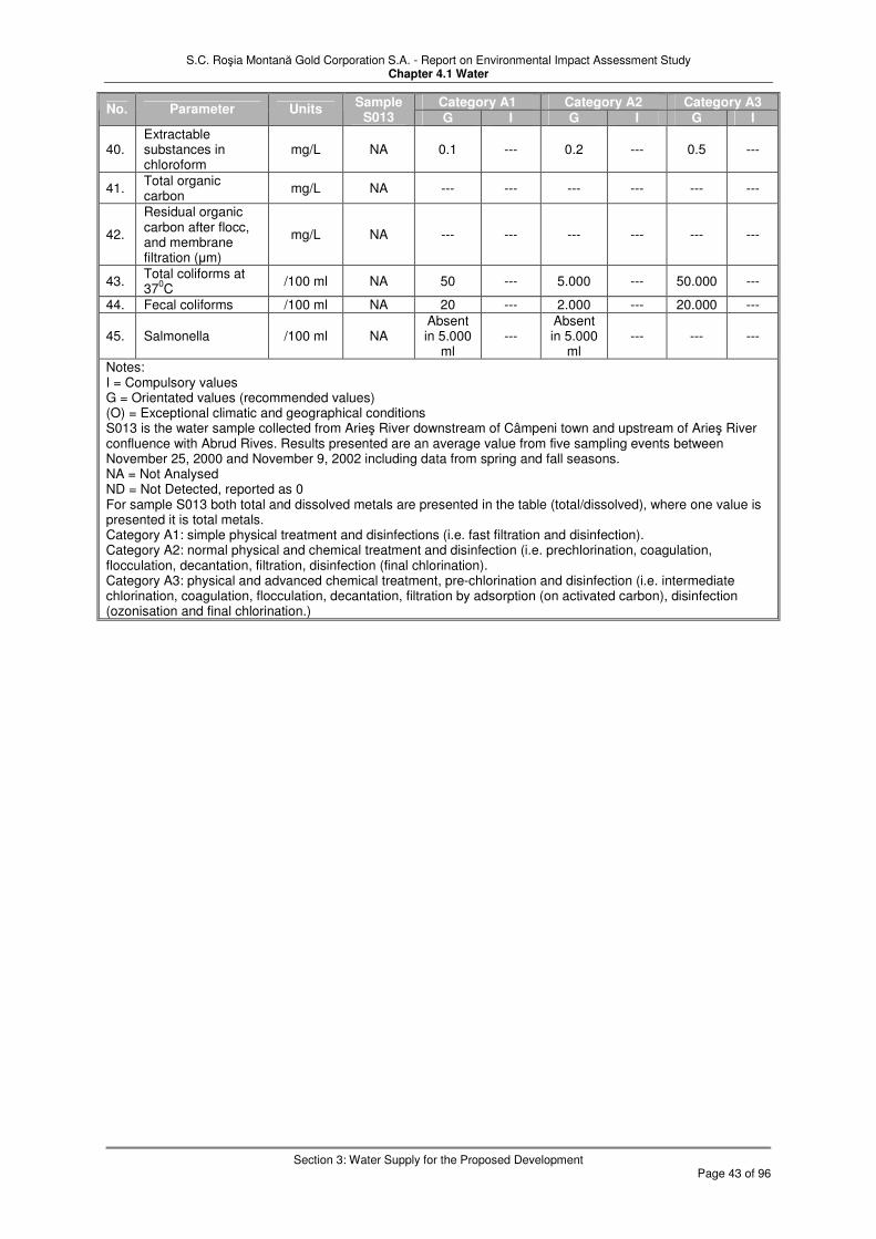
S.C. Roşia Montană Gold Corporation S.A. - Report on Environmental Impact Assessment Study Chapter 4.1 Water
Section 3: Water Supply for the Proposed Development
Page 43 of 96
Category A1 Category A2 Category A3 No. Parameter Units
Sample S013 G I G I G I
40. Extractable substances in chloroform
mg/L NA 0.1 --- 0.2 --- 0.5 ---
41. Total organic carbon
mg/L NA --- --- --- --- --- ---
42.
Residual organic carbon after flocc, and membrane filtration (µm)
mg/L NA --- --- --- --- --- ---
43. Total coliforms at 37
0C
/100 ml NA 50 --- 5.000 --- 50.000 ---
44. Fecal coliforms /100 ml NA 20 --- 2.000 --- 20.000 ---
45. Salmonella /100 ml NA Absent in 5.000
ml ---
Absent in 5.000
ml --- --- ---
Notes: I = Compulsory values G = Orientated values (recommended values) (O) = Exceptional climatic and geographical conditions S013 is the water sample collected from Arieş River downstream of Câmpeni town and upstream of Arieş River confluence with Abrud Rives. Results presented are an average value from five sampling events between November 25, 2000 and November 9, 2002 including data from spring and fall seasons. NA = Not Analysed ND = Not Detected, reported as 0 For sample S013 both total and dissolved metals are presented in the table (total/dissolved), where one value is presented it is total metals. Category A1: simple physical treatment and disinfections (i.e. fast filtration and disinfection). Category A2: normal physical and chemical treatment and disinfection (i.e. prechlorination, coagulation, flocculation, decantation, filtration, disinfection (final chlorination). Category A3: physical and advanced chemical treatment, pre-chlorination and disinfection (i.e. intermediate chlorination, coagulation, flocculation, decantation, filtration by adsorption (on activated carbon), disinfection (ozonisation and final chlorination.)

S.C. Roşia Montană Gold Corporation S.A. - Report on Environmental Impact Assessment Study Chapter 4.1 Water
Section 3: Water Supply for the Proposed Development
Page 44 of 96
3.3 Summary
� A major objective of the project is to minimise use of regional and local fresh water supplies. To that end, the project will maximise recycling and re-use of water onsite. However, some fresh water supply will be required. The estimation of fresh water and other water supply requirements is largely derived from the Project water balance.
� The Roşia Montană processing plant will require a constant and reliable water supply of water. On average 80% of the water required for the plant will come from recycled water from the TMF, which will be supplemented with recycled water from the Wastewater Treatment Plant (15%) and plant site runoff and fresh water abstracted from the Arieş River (5%).
� Under average climatic and typical operating conditions, the Project will require an estimated average supply rate of recycled, fresh and other water over the life of the mine of 1,482 m3/hr of which approximately 207 m3/hr will need to be freshwater.
� Fresh water is required for supply of potable water for domestic and sanitary use, fire protection and reagent mixing, and for make-up water for processing or maintaining baseflows in the Roşia or Corna streams on the rare occasions when process water supply from the TMF decant pond may be insufficient (19.3 m3/hr on average).
� Several options for the raw (fresh) water supply were studied. It is proposed that abstraction will be from the Arieş River, via an intake located upstream of the confluence with the Abrud River. The quality of Arieş River water at the proposed intake site is adequate for the industrial processes and limited potable water supply.
� Based on the minimum daily recorded flow in the Arieş River and the maximum actual abstraction rates by other users, the Project would have 100% reliable water supply, while at the same time allowing three times higher minimum environmental flow than required by Apele Române. If the existing users were to abstract up to their maximum licensed amount, the Arieş River would still meet all demands 96% of the time. The remaining 4% of the time represents periods of extreme low flow. Given that actual abstraction is only 16% of the licensed abstraction, it appears highly likely that sufficient flow would be available.
� The water supply is expected to provide a reliable source of water to the Project, without impacting other water users in the area. No interference with the municipal potable water supply system is envisaged.
� A potable water treatment plant will be constructed and operated at the Roşia Montană site. The objective of the plant is to supply potable water to plant facilities only. Although a certain reserve capacity will be designed into the system, no off-site distribution of treated potable water is anticipated. Based on an evaluation of the Arieş River upstream of Abrud confluence and the recommended Romanian treatment requirements, the only treatment components will be physical treatment and disinfection.

S.C. Roşia Montană Gold Corporation S.A. - Report on Environmental Impact Assessment Study Chapter 4.1 Water
Section 4: Wastewater Management
Page 45 of 96
4 Wastewater Management
4.1 Introduction
This section provides details on the wastewater management strategy for the construction, operational, closure and post-closure periods of the project. The situations of temporary cessation and storm events are also considered. Four major types of wastewater will be managed at the Roşia Montană site (Figure 4.1.11, Simplified Water Balance Schematic and Exhibit 4.1.12, Water Balance Flowchart). Figure 4.1.11 illustrates in general how fresh/treated water, detoxified tailings water, acid rock drainage (ARD) and domestic wastewater treatment effluent are managed within the overall facility. Note that the only wastewater discharges to the environment from the facility during normal conditions occur in respect of treated water from the (ARD) Wastewater Treatment Plant to the Roşia and Corna Streams, including provision of compensation flows where required; and during the latter stages of operation and post-closure from the Cârnic waste rock drainage pond (providing this is in compliance with NTPA 001/2005 (TN001)). More specific details of the Project wastewater discharges is contained in Section 4.3. and Exhibit 4.1.17. Discharge from the TMF via the secondary containment dam to the Corna valley is not part of normal operations, and would not take place in any event unless it was in compliance with NTPA 001/2005 (TN001). All other wastewater flows (detoxified tailings water, domestic wastewater treatment effluent) and managed internally within the facility and do not constitute sources of wastewater discharge to the environment. Exhibits 4.1.10, Fresh and Domestic Wastewater Flowchart, 4.1.11, Water Treatment Flowchart, and 4.1.12, Process Water Flowchart contain general flow diagrams showing how the wastewaters will be managed from the source. These wastewaters comprise:
� Process water
� Acid rock drainage
� Domestic wastewater
� Impacted storm water
Section 4.2 provides the following information for the four wastewater types:
� Description of Wastewater Management
� Sources
� Collection
� Treatment
� Reuse
� Flow quantities
� Sludge (or tailings)
Under normal operating conditions, the main discharge from the Project is from the Wastewater Treatment Plant which manages the acid rock drainage. Wastewater discharges from the Project are discussed in section 4.3 which includes the following information: Wastewater Discharges
� Quantity and temporal variation of discharge flow
� Quality pre-treatment
� Quality of discharged wastewater
� Quality of receiving water prior to discharge
� Quality of receiving water after discharge
� Comparison with water quality standards

S.C. Roşia Montană Gold Corporation S.A. - Report on Environmental Impact Assessment Study Chapter 4.1 Water
Section 4: Wastewater Management
Page 46 of 96
Exhibit 4.1.2 presents the required Table 4.1.1 of Ministerial Order 863. The exhibit summarises the data regarding the water sourced by the Project and water reuse by the Project. A more detailed presentation is given in Exhibit 4.1.12, Water Balance Flowchart. These data were derived from the Site Water Balance Report together with its subsequent revisions (which take account of recent rainfall data and a modified water management strategy adopted to ensure compliance with discharge standards) – see Appendix 4.1C for explanation of the derivation of values in Exhibit 4.1.2. These describe the calculation methodology and the detailed analysis. Column 6 of Exhibit 4.1.2, industrial wastewater discharge sums the flows at streams 35, 37 and 42 from Exhibit 4.1.12. [Stream 42 is 25 m3/day throughout the project life and stream 37 is expected to be 0 m3/day]. Column 8, the water discharged to the atmosphere by evaporation sums the flows at streams 18, 20, 25, 28 and 49. Water reuse by the project, column 10, is taken as the sum of the transfers for reuse purposes between areas 1-9 shown on Exhibit 4.1.12. These comprise streams 10, 22, 27, 31, 32 and 34. The total of wastewater produced, column 2, is the sum of columns 6, 8 and 10. A detailed description of the water management is given in the Water Management and Erosion Control Plan and is also presented in the context of the technological processes of the Project in Chapter 2 of the EIA. The site-wide water balance includes maximum, minimum, and average flows for each Project area. The process areas are grouped in the exhibits as follows:
� Area 1 – Processing Facilities / Operations (Exhibit 4.1.16)
� Area 2 – Cârnic Waste Rock Area (Exhibit 4.1.15)
� Area 3 – Cetate Drainage Collection Area (Includes all the pits, 714 Adit and Cetate waste rock disposal area) (Exhibit 4.1.15)
� Area 4 – Wastewater Treatment Area (Exhibit 4.1.15)
� Area 5 – Tailings Management Facility (Exhibit 4.1.16)
� Area 6 – Fresh Water Supply (Exhibit 4.1.14)
� Area 7 – Water Storage (Exhibit 4.1.14)
� Area 8 – Potable Water (Exhibit 4.1.14)
� Area 9 – Domestic Wastewater (Exhibit 4.1.14)

S.C. Roşia Montană Gold Corporation S.A. - Report on Environmental Impact Assessment Study Chapter 4.1 Water
Section 4: Wastewater Management
Page 47 of 96
Figure 4.1.11 Simplified water balance schematic
Project Boundary
TM
Process Plant Cyanide detox
TMF decant pond/process plant
ARD WWTP
Carnic waste drainage pond
Cetate Water Catchment Dam and Pond
Waste rock stockpiles Pits Low grade ore stockpile 714 Adit
Rosia stream
Corna stream
Freshwater supply from River Aries
DWTP
Domestic use
Compensation water
SCD
CTP*
TMF - Tailings management facility ARD WWTP - Acid rock drainage wastewater treatment plant DWTP - Domestic waste water treatment plant SCD - Secondary catchment dam CTP* - Contingency cyanide treatment plant - available but only used in operations if required to recover TMF storage after PMP event for example; in closure may be used when pumping decant pond water to Cetate pit lake. Semi-passive treatment lagoons may also be in place (see text). ARD/potential ARD water Detoxified tailings water
Treated domestic wastewater
Treated ARD water (to TN001 discharge standard) Fresh water
Pumpback
To TMF if treatment not needed

S.C. Roşia Montană Gold Corporation S.A. - Report on Environmental Impact Assessment Study Chapter 4.1 Water
Section 4: Wastewater Management
Page 48 of 96
4.2 Wastewater Arisings and Management
4.2.1 Process Wastewater Cyanide will be used in the Project for the carbon-in-leach (CIL) process in the extraction of gold. Most cyanide will be recovered in the plant as illustrated in Exhibit 4.1.15 and discussed in Section 2.3.3, however, a residual will remain in the tailings. The detoxified tailings comprise the only process wastewater source for the Project. Residual cyanide concentrations in the treated tailings slurry will be subject to compliance with the EU Mine Waste Directive which stipulates a maximum of 10 ppm WAD CN. Cyanide will be present as a potential pollutant at the site in (artificial) surface water only during the operational phase and the first year or two following closure. Modelling of the predicted concentrations in the TMF has shown that treated process plant tailings flow is expected to contain 2 to 7 mg/L total cyanide. Further degradation will reduce the concentrations to below applicable standards in surface water within 1-3 years of closure. A secondary effect of this treatment is also the reduction of many of the metals which may potentially occur in the process water stream. An assessment of the likely chemical makeup of the tailings leachate, based on testing, is summarised in Table 4.1-18 (section 4.3.). 4.2.1.1 Normal Operating Conditions The TMF is a closed system and no discharge to the environment of cyanide-containing process water in excess of the NTPA 001/2005 (TN001) standards will be allowed during the mine life even during extreme climatic conditions (the TMF can retain two successive Probable Maximum Floods (PMFs)). If discharge is necessary, for example in order to preserve extreme event storage capacity, and the residual cyanide is not sufficiently degraded and diluted, cyanide will be treated further to achieve compliance with TN001. This secondary treatment will be based on one of the following technologies: activated carbon adsorption, bone char adsorption, reverse osmosis or SO2/air. All four options will be trialled during the construction phase to determine the best method to use, and the preferred plant will be ready for construction at the beginning of operations. Other constituents in the tailings water that could preclude a direct discharge to the environment from the TMF include calcium, sulphate, total dissolved solids, and by-products from cyanide dissociation, particularly ammonia, nitrate and nitrite. The only water leaving the main tailings impoundment under normal operation will be dam seepage which is collected in the Secondary Containment Dam (SCD). However, this water will be captured and pumped back to the TMF. Discharge from the project will only be considered if, inter alia, the water is in compliance with NTPA 001/2005 (TN001) standards. The provision to pump this water back to the TMF and maintain a closed system will be maintained throughout the operational period. Runoff and seepage from the Cârnic Waste Rock dump will be allowed to flow into the TMF if the water quality is not significantly impacted by ARD. If impacted by ARD, the seepage and runoff will be captured and pumped to the Waste Water treatment plant. Compensation flow requirements to the Roşia and Corna streams will be met using treated water from the ARD treatment plant that meets the TN001 standards, and/or water from the freshwater system, as needed. A line of three to five boreholes will be installed downstream of the SCD to confirm by monitoring that the TMF water is being contained by the seepage collection system. If TMF hydrochemcial parameters are ever detected in the monitoring wells above regulatory standards, groundwater recovery will become a component of the seepage collection system. Seepage water from the recovery wells will be pumped back to the TMF reclaim pond for recycling in the process. During the operational period, the semi-passive treatment (wetland) facility downstream of the SCD (scheduled for implementation during post-closure, see below) will be constructed and tested. This facility will principally remove ammonia, sulphate and low concentrations of residual cyanide, and thereby contribute to the amelioration of effluent to concentrations at which it can be released in accordance with appropriate discharge standards. Any effluent

S.C. Roşia Montană Gold Corporation S.A. - Report on Environmental Impact Assessment Study Chapter 4.1 Water
Section 4: Wastewater Management
Page 49 of 96
from the constructed wetland that does not meet the discharge standards will be pumped back to the TMF. Test procedures will include optimisation of the size of the lagoons, the placement of organic substrate to enhance their bio-availability, and optimisation of the oxygen-consumption properties of the cover system on top of the anaerobic parts of the lagoon. 4.2.1.2 Extreme Event Conditions The Secondary Containment System would be operated at a sufficiently low level to allow for natural storm water dilution to within TN001 compliance for discharge. of the water still contained in it by storm water runoff to within TN001. Should the need arise to reduce the level of the TMF decant pond due to extreme precipitation conditions, that is, in the extremely unlikely event of more than two PMPs in succession, this will be carried out via Secondary Cyanide Treatment Plant if not appropriate for direct release in accordance with the appropriate discharge standard. Unimpacted runoff from the Cârnic waste rock stockpile will be allow to flow into the TMF. If impacted by ARD, the runoff will be pumped to and treated at the Waste Water Treatment plant. If the Cârnic storm water exceeds the capacity of the collection pond or ditches, it will flow into the TMF. This flow is accounted for in the PMF calculation. 4.2.1.3 Temporary Cessation Pumping of treated slurry from the Cyanide Detox plant and recycling of water from the TMF reclaim pond will stop. The reclaim pond volume will then increase due to a positive water balance. However, due to a large reserve storage capacity, there will be excess capacity in the reclaim pond above that required for extreme storm events. The amount of excess capacity will depend upon the stage of the Project and required storm capacity storage. Once the excess capacity is filled in the pond, water would have to be treated via the Secondary Cyanide Treatment Plant (and/or the Waste Water treatment system, depending on the non-TN001 compliant contaminants concerned) unless the quality was such as to enable direct discharge to occur within the appropriate discharge conditions. Seepage collected in the SCD pond will continue to be pumped to the reclaim pond. Seepage and runoff from the Cârnic waste rock stockpile will be allowed to flow to the TMF unless the water quality would impact restart of the process. In this case, the runoff and seepage would be pumped to the Waste Water treatment plant. 4.2.1.4 Closure During the closure phase, the TMF decant pond will be pumped to the Cetate pit lake as soon as levels are reduced to below 0.1 mg/L total cyanide, either naturally or with secondary treatment. Residual process water seepage that will pass through the TMF embankment to the Secondary Containment System may also contain trace concentrations of cyanide. However, natural degradation and attenuation processes will limit the amount of cyanide that is present in the seepage. Seepage water in the SCD pond will continue to be pumped to the TMF decant pond as long as it is present. Once the TMF decant pond is removed the seepage water will be pumped to the mine pits, via secondary cyanide treatment if necessary to reduce concentrations to 0.1 mg/L total CN. Alternatively, it may be treated in the semi-passive wetland treatment cells below the SCD and discharged to the Corna valley. Seepage from the Cârnic waste rock stockpile will be pumped to the Cetate pit lake if impacted by ARD, where it will be treated in-situ or through the Waste Water Treatment plant. Otherwise, the water will be discharged to the Corna Basin. 4.2.1.5 Post-Closure During post-closure the reclaim pond will no longer be present. Surface water runoff from the basin will be routed around or off the TMF and discharged into Corna Stream below the SCD. As during previous phases, the dilution in the secondary containment system would be sufficient to reduce concentrations of TMF constituents to below TN001 standards if a storm water discharge were to occur from the SCD. Seepage water in the SCD pond will be pumped to the pits via secondary treatment if not suitable for direct release. Alternatively, it

S.C. Roşia Montană Gold Corporation S.A. - Report on Environmental Impact Assessment Study Chapter 4.1 Water
Section 4: Wastewater Management
Page 50 of 96
may be treated in a series of semi-passive wetland treatment cells below the SCD and discharged to the Corna valley. The Cârnic waste rock stockpile will have been covered and runoff will be directed to Corna stream. Seepage will be greatly reduced. If present in a quantity and quality that requires additional management, this water will be pumped to the mine pits. 4.2.1.6 Process Wastewater Reuse There will be no process wastewater flows during the construction and closure phases of the Project. The primary use of the process wastewater is recycling in the process. On average 80% of the water required for the plant will come from recycled water from the TMF. The main flow quantities include an average reclaim flow from the TMF of 1,192 m3/hr, and 1,553 m3/hr detoxified process water flowing to the TMF. The difference between the quantity of water reused compared to the water flowing into the TMF is accounted for by the water that will be retained in the tailings mass, and evaporation losses. 4.2.1.7 Process Wastewater Discharge Quantities and Temporal Variation There will be no process wastewater discharge during any phase of the Project, unless it meets regulatory standards, including the extremely unlikely event of two PMPs occurring in succession. In such an event, natural dilution from stormwater runoff into the SCD would achieve TN001. 4.2.2 Acid Rock Drainage The main ARD sources are:
� Existing sources (waste rock piles, 714 Adit, historical mine workings)
� Project-related sources (Cetate and Cârnic waste rock piles, low grade ore stockpile)
4.2.2.1 Existing acid rock drainage Existing rock drainages will be collected behind the Cetate Water Catchment Dam, from where they will be pumped to the wastewater treatment plant. Existing flows from the 714 Adit alone are estimated to average 51 m3/hr with a maximum monthly flow of approximately 63 m3/hr. During the construction phase of the Project acid rock drainage derived from existing sources will be contained once the Cetate Water Catchment Dam and Pond and Wastewater Treatment Plant are constructed. Completion of the wastewater treatment plant will occur late in the construction phase or early in the operational phase of the Project. 4.2.2.2 Acid Rock Discharge Wastewater Treatment ARD waste water treatment is based on two principal treatment steps:
� Neutralisation with precipitation of dissolved metals, and clarification
� pH adjustment with CO2 and clarification
The process can also be optimised for advanced removal of calcium. In a third step, sulphate and TDS will be reduced below TN001 requirements. Treated water is used as process water or as flow compensation in the Roşia and Corna streams. The processes are described in Chapter 2. 4.2.2.3 Normal operating conditions Project related sources of acid rock drainage will not become significant until the operation phase of the Project. The sources of acid rock drainage will include the Cetate Waste Rock Disposal Site, the Cârnic Waste Rock Disposal Site, and the Low-grade Ore Stockpile. These sources will be present during operation. Acid rock drainage generation may also occur on the mine pit walls. This water will report to the 714 adit, either through direct flow or in-pit pumping. The 714 Adit flow is expected to increase slightly as the mine pits advance and more precipitation is captured and directed into the underground mine system. In effect, the 714 adit will act to drain the mine pits until the pits advance below the 714 m level. It is anticipated that additional acidic water may be generated from the waste rock and low-grade

S.C. Roşia Montană Gold Corporation S.A. - Report on Environmental Impact Assessment Study Chapter 4.1 Water
Section 4: Wastewater Management
Page 51 of 96
ore stockpiles that will be constructed as part of the mining operation. The probability of acid rock drainage generation from the low-grade ore stockpile is higher than from the waste rock, where acid rock drainage may not occur due to a bulk net-neutralising character (see Section 4.5, Subsoil Geology). 4.2.2.4 Storm conditions Water from most storm conditions will be contained and treated. The Cetate water catchment dam is designed to retain the rainfall and associated flood water from a 1:100 year 24-hr event. The Cetate water catchment pond levels will be operated at sufficiently low levels to allow storm water runoff to provide dilution to meet NTPA 001/2005 (TN001) standards, except with the possible exception of pH. As a mitigation measure, the spillway and Cetate dam face will be constructed with limestone. The ARD treatment plant will continue to operate and discharge as during normal operating conditions. This plant will be operated at a maximum rate to reduce storm water storage in the water management system. 4.2.2.5 Temporary cessation Management of wastewater in the Roşia Basin will be the same as during normal operating conditions. However, depending upon the stage of the project, addition water storage capacity may be available in the mine pits. This may allow for some additional flexibility in wastewater management. 4.2.2.6 Closure Both existing and Project-related sources of acid rock drainage will be substantially reduced in the closure phase. During the closure phase, acid rock drainage will be reduced through the removal and closure of facilities such as the ore stockpiles and the waste rock facilities, respectively. Closure activities will reduce the potential for water to contact acid rock generating materials and also reduce the process of oxidation and acid generation (ref to closure plan). In closure, all ARD water will report to the Cetate mine pit or directly to the ARD wastewater treatment plant. Water will be allowed to accumulate in the Cetate pit lake. In-pit water treatment will be conducted if needed and functional. The Cârnic, Jig and Orlea pits will be backfilled. Although ARD may still be generated on the pit slopes above the backfill, this will be collected in drainage channels at the base of the slopes and report to the Cetate water catchment dam. Other sources will be reclaimed with covers and vegetation to reduce or eliminate the generation of acid rock drainage if it is occurring. Some residual seepage from the waste rock facilities may require collection and treatment for a period of time if acid rock drainage is present. The low-grade ore stockpile will be removed through processing, so this potential source will not be present. Acid rock drainage seepage from the face of the TMF may also occur. However, the dam will be covered to reduce or eliminate the potential generation and seepage of acidic water, and a treatment system will be in place to manage this potential minor source. The Cetate water catchment pond levels will be operated at sufficiently low levels to allow storm water runoff to provide dilution to meet TN001 standards, except pH, as noted above. While the Cetate pit lake is filling, the requirement to discharge treated water will be reduced to that needed to supplement compensation flows in the Roşia and Corna streams. If the Cetate pit lake reaches an optimal operating level during the closure period, a discharge through the ARD wastewater treatment plant is likely to be needed. The treatment plant will then operate and discharge as during normal operating conditions. 4.2.2.7 Post-closure The Cetate water catchment pond will be present to collect seepage from the Cetate pit lake and seepage from the Cetate waste rock dump. This water will be pumped back to the Cetate pit lake or treated in the ARD waste water treatment plant and then discharged to the Roşia valley. The 714 Adit downstream of the bulkhead will act to intercept pit lake seepage and direct it to the Cetate water catchment pond. Cetate pond levels will be operated at

S.C. Roşia Montană Gold Corporation S.A. - Report on Environmental Impact Assessment Study Chapter 4.1 Water
Section 4: Wastewater Management
Page 52 of 96
sufficiently low levels to allow storm water runoff to provide dilution to meet TN001 standards, except pH. A continuing, but reduced level of wastewater treatment for acid rock drainage is likely to be required for several years following closure. This treatment will be similar to that used during the operational phase described in Section 2. The plant will be used to help treat the pit lake water and provide a means to discharge pit lake water to the Roşia valley, whilst meeting TN001 standards. In-pit treatment will be evaluated and implemented to improve pit lake water quality. This will include the liming from the ARD waste water treatment plant but may also include biological treatments. Biological treatment cells can replace the active ARD waste water treatment plant once water quality has sufficiently improved in the Cetate pit lake. Specifics of the system will be developed as the Project proceeds and as more hydrological and water quality data are developed to allow for a more accurate prediction of the water quality and associated treatment requirements. 4.2.2.8 Treated Wastewater Flow Quantities and Temporal Variation The main existing source of ARD is the 714 Adit with an approximate average of 51 m3/hr with a maximum monthly flow of approximately 63 m3/hr. Flow rates for the seeps from the existing waste rock piles have not been quantified because of their non-point source nature. Any acid rock drainage generated from excavations during the construction phase is expected to be minor and will be handled by Best Management Practices (BMPs). ARD generation is more likely to occur during later stages of the construction period due to the potential exposure of ARD generating materials during the course of construction and the lag time for ARD generation. However, by this time the wastewater treatment system will be available. Once the Cetate Water Catchment Pond and Waste Water Treatment Plant are operational uncontrolled discharge of existing acid rock drainage will cease and all acid waste water from the Project will either report to the Waste Water Treatment Plant or to the Cetate Water Catchment Pond (or in the case of the Cârnic waste drainage holding pond during storm events, to the TMF). In either case, discharges to the environment will be in compliance with NTPA 001/2005 (TN001), with possible exception of slight exceedances with respect to pH. During the operation phase, acid rock drainage will be collected from the existing sources. Flow from these sources will be reduced as existing waste rock areas are incorporated into the Project and the mine pits consume the underground mine workings. However, any flow from the 714 Adit associated with the underground mine workings will be replaced by increasing possible ARD flows from the mine pit walls. As illustrated in Exhibit 4.1.12, potential acid rock drainage flow in the Roşia Valley (including mine pits, waste rock and ore stockpiles) is expected to range from 231 to 349 m3/hr under average conditions, which will be routed to the Cetate Water Catchment Pond and the Wastewater Treatment Plant. Peak rates in Year 7 could be up to 600 m3/hr (170 L/s) with water from the Orlea and Jig pit areas. This will be added to by the Cârnic waste dump runoff and seepage in the Corna Valley. This flow is expected to range from approximately 44 to 50 m3/hr as shown on Exhibit 4.1.12. Acid rock drainage generation is also possible on the TMF downstream dam face in the Corna Valley. The material used in construction will be managed to reduce the potential for acid rock drainage generation, and an estimate of possible acid rock drainage flow has not been developed. However, this flow is accounted for and included in the flow that will be captured in the Secondary Containment System as mentioned in the section discussing Process Wastewater. Flow rates for the seepages from the existing waste rock piles have not been quantified because of their non-point source nature. These seepages will be present during all three phases of the Project but will be reduced over time as the Project consumes or relocates many of these existing mine waste areas to managed facilities. From a geochemical viewpoint it is not possible to accurately predict the amount of acid rock drainage from the pit walls and the residual seepage from waste rock facilities. However, because of the closure activities, the acid rock drainage flows are expected to be at least an order of magnitude less than the flows during the operational phase, but some longer-term

S.C. Roşia Montană Gold Corporation S.A. - Report on Environmental Impact Assessment Study Chapter 4.1 Water
Section 4: Wastewater Management
Page 53 of 96
water treatment is still likely to be required during the closure phase. The amount of this flow will be further defined in the operational phase as closure approaches and additional data are available. 4.2.2.9 Wastewater Reuse Wastewater from the wastewater treatment plant is reused in two ways. A component is supplied to the process water tank for reuse in the process, either directly or as water in the treatment plant sludge via the TMF reclaim pond. This quantity decreases from 159 m3/hr to zero through the project under average conditions, with a life-of-mine average of 76 m3/hr. Water contained in the treatment plant sludge (about 3 m3/hr) also reports to the TMF and possible recycle. 4.2.2.10 Wastewater Treatment Plant Discharge Treated wastewater from the Wastewater Treatment Plant will be directed to the Roşia and/or Corna Valley to meet required compensation flows when flow from the unimpacted surface water diversions is not sufficient. This discharge varies from 120 to 349 m3/hr under average conditions. Two pipelines will be installed and will discharge in the locations shown on Exhibit 2.9 in Chapter 2. The first pipeline will be routed from the Wastewater Treatment Plant to the Cetate Water Catchment Dam and Pond. The discharge point in Roşia Valley will be located just downstream of the Cetate Water Catchment Dam and Pond. The second pipeline will be routed from the Wastewater Treatment Plant to the TMF area. It will continue past the Secondary Containment Pond where the pipeline will discharge to Corna Valley. The system of discharges to Corna and Roşia Valleys from the Wastewater Treatment Plant will be maintained into the closure phase. However, the need to discharge treated water to the Corna Valley will be eliminated once the closure of the TMF is completed. This is because in the final design, the majority of the original catchment will again flow to the Corna Stream. Runoff from the covered TMF will be allowed to flow from the facility. The presence of the pit lake system in the Roşia Valley may still result in a flow deficit in the valley. A treated discharge may periodically be needed to maintain baseflow during pit lake filling as a result. Once the pit lake level reaches it optimal management level, a continual treated discharge to the Roşia Valley may be required until lake water quality is sufficient for a direct discharge or a discharge through a semi-passive wetland treatment system. 4.2.3 Domestic Wastewater 4.2.3.1 Domestic Waste Water Treatment Until the completion of the domestic wastewater collection and treatment system during the construction phase, temporary sewage collection and treatment will be provided to service the construction camp. This temporary system will meet regulatory discharge requirements for discharge to the Roşia stream. In addition, portable toilet facilities will be located in outlying areas for use by contractors during construction and operation. Once constructed, the Domestic Wastewater Treatment Plant (sewage treatment plant) will receive domestic wastewater collected from the mineral processing facility as illustrated in Exhibit 4.1.14. The treated water will be directed to the TMF for all but a period of less than a year during the construction period. Prior to the completion of the TMF starter dam, a temporary discharge from the site will be required that will comply with the applicable regulations. During the closure phase the domestic wastewater system will be left in place until closure construction is mostly complete. Depending upon the requirements of the final closure plan and the possibility of any future site development, it will be considered whether or not to dismantle the system or transfer it to a local municipal authority. Preference will be given to transferring the system to a local authority for the beneficial use of the local community. However, if the system is not needed and is dismantled, a smaller system or connection to another existing system will be provided to supply the requirements for any staffing associated with industrial wastewater treatment facilities that will remain longer-term.

S.C. Roşia Montană Gold Corporation S.A. - Report on Environmental Impact Assessment Study Chapter 4.1 Water
Section 4: Wastewater Management
Page 54 of 96
4.2.3.2 Treated Domestic Wastewater Flow Quantities and Temporal Variation During the construction phase, and based on the projected number of construction workers of approximately 1,200 and assuming a per capita demand similar to the operational phase, flow from this system is expected to be approximately 10 m3/hr or less. As indicated in Exhibit 4.1.14, the domestic wastewater generation during the operational period is expected to be approximately 5 m3/hr for 400 to 600 site workers. During the initial year of start up there will be up to 600 staff on site, and wastewater generation may be slightly greater than in following years when the staff will be nearer to 400. During the operational period, treated wastewater will be directed to the Tailings Storage Facility and reclaimed for ore processing. During the closure phase the wastewater generation will be reduced as the number of workers is reduced. A provision will be made for the small quantity of wastewater generated as the result of staffing any longer-term water treatment facilities. Such flow is expected to be less than 0.1 m3/hour. 4.2.3.3 Treated Domestic Wastewater Discharge The treated effluent from the Domestic Wastewater Treatment Plant will flow by pipeline to the process plant area and will be connected to the tailings delivery line immediately downstream of the cyanide detoxification process. There are no provisions for direct discharge of treated domestic wastewater to the receiving streams, except prior to (construction phase) and after (closure phase) the ability of the TMF to receive the effluent. During this short time period of construction the discharge will be to Roşia Valley. In closure, the treated discharge will also be to the Roşia Valley but long-term will be significantly less than during the other phases of the Project. 4.2.4 Impacted Storm Water 4.2.4.1 Management Storm water emanating from disturbed areas may contain elevated levels of total suspended solids, but also may contain elevated levels of total metals if mineralised areas are involved. Management of storm water using standard practices for construction sites and retention of storm water on site will control this source of potential pollutants. Beginning during the construction phase Best Management Practices (BMPs) will be utilised to control suspended solids as described in the Water Management Plan and Erosion Control Plan, and storm water will be discharged to the Roşia or Corna Streams. During the construction period new chemically impacted water is not expected to be significant. In the operational phase, site storm water will be captured in the TMF, plant storm water pond and the Cetate Water Catchment Dam. Off-site storm water will be directed around disturbed on-site areas and mine waste storage areas. Storm water impoundment on site will be directed to the wastewater management systems. Storm water from waste rock stockpile areas, ore stockpiles and the mine pit walls could transport acid rock drainage that may have been generated. This water will be directed to the wastewater treatment system. A key component of closure will be to reduce or eliminate most impacted storm water flows. This will be accomplished through the closure and reclamation of the facilities. In closure, the BMPs and stormwater collection systems will remain in place as needed. The revegetation of most of the site areas will substantially reduce the need to control storm water once the vegetation is established. In closure, the direct contact of storm water with potentially acid rock drainage generating materials will also be mostly eliminated. The exception will be the mine pit walls. This runoff will be managed as part of the mine pit closure design of foot slope drainage in the case of the backfilled pits (Jig, Orlea and Cârnic) and containment in the Cetate pit lake, where longer-term management and treatment will be required before discharge to the Roşia valley. In post-closure, the need for impacted storm water management will eventually be eliminated as the result of the closure reclamation activities.

S.C. Roşia Montană Gold Corporation S.A. - Report on Environmental Impact Assessment Study Chapter 4.1 Water
Section 4: Wastewater Management
Page 55 of 96
4.2.4.2 Impacted Storm Water Quantities The quantity of impacted storm water is directly related to intensity of storm events. During the construction phase, the area of disturbance will also be highly variable and therefore the quantities of impacted storm water will vary and it is difficult to provide an accurate representation. For the operational phase, the storm water flows from the various project facilities have been accounted for in the water balance. 4.2.4.3 Facility Specific Comments
� Cetate Dam Discharge
The water from the plant site storm water containment ponds will be directed to the Wastewater Treatment Plant. The Cetate Water Catchment Dam and Pond will collect current and potential future impacted runoff and seepage water from the Roşia Valley catchment. This water will originate from the surface facilities on the south flank of the Roşia Valley in the Project area, including the Low Grade ore stockpile, and from the area contained within the Northern Diversion perimeter on the north flank. The Cetate Water Catchment Dam and Pond will also collect drainage from underground historic mine workings through the 714 Adit. At the later stages of mine development, when mine pit bottoms are below the 714 Adit level, the adit will be sealed with a bulkhead so that water stored in the Cetate Water Catchment Dam and Pond will not backup into the mine pits. Pit water will be pumped to the Wastewater Treatment Plant through the Cetate Water Catchment Dam and Pond. The Cetate Water Catchment pond is designed to retain all floods up to the 1:100 yr 24-hour event with the pond at maximum operating level before the storm. In practice it can store events up to the 1:200 year 24-hour event at this level, and at normal operating levels up to at least the 1:1,000 year 24-hour event. For events greater than the 1:100 yr 24-hour event, the spillway will be designed to safely pass the design flow rate from the 1:1,000 yr 24-hour event.
� Cârnic Waste Rock Drainage Pond
The Cârnic Waste Rock Drainage Pond will be constructed upstream of the tailings impoundment, immediately downstream from the Cârnic Waste Rock Disposal Site. The facility will be designed to collect runoff that is possibly acidic from the waste rock and pump it to the Wastewater Treatment Plant. This will prevent the water from mixing with the tailings pond water and impacting the reclaim water required for processing. This dam will be constructed at the onset of impacted drainage from the disposal site, which could be up to two years after the start of operations. Runoff collection ditches will be constructed on the downstream side of the waste rock disposal site to collect seepage and runoff and route it into the drainage pond. A spillway will be constructed in the containment pond embankment that will control the flows from large storm events (over 1:25 year 24-hour event by design criterion, but 1:50 year 24-hour event in practice) that will be directed into the TMF Reclaim Pond. The effects of a flow from the Cârnic Waste Rock Disposal Site to the TMF during an extreme storm event have been accounted for in the evaluation of the TMF capacity.
� Plant Area
Once the processing plant is constructed, storm water from the processing plant will be directed to the plant storm water pond, which will also act as a secondary spill containment system. The storm water in this area could come in contact with the mineral processing facilities and may be impacted. Under normal operations, a pump station located at the pond will deliver the storm water to the Cetate Water Catchment Dam and Pond for subsequent treatment at the Wastewater Treatment Plant. Alternatively, the collected storm water can be pumped to the process water tank for use in the mineral processing. The storm water pond will be sized to handle a 1:25-year 24-hour storm event. The Plant Area storm water management system will be demolished when the plant site is decommissioned. Until the plant site is reclaimed or otherwise developed, storm water runoff will be managed per the RMGC Water Management and Erosion Control Plan.

S.C. Roşia Montană Gold Corporation S.A. - Report on Environmental Impact Assessment Study Chapter 4.1 Water
Section 4: Wastewater Management
Page 56 of 96
4.3 Discharges to the Environment by the Proposed Project
The project produces four types of wastewater; process, acid rock drainage, domestic and impacted storm water. A summary of the wastewaters that are discharged to the environment is presented in Exhibit 4.1.17 and in this section the following information is given regarding them:
� Location
� Quantity and Temporal Variation of Discharge Flow
� Quality pre Treatment
� Quality of Discharge Wastewater
In order to make comparison between the quality of the discharged water and the environment into which they are discharged, the following information is given for both discharge locations (Rosia and Corna).
� Quality of receiver upstream of the discharge point
� Quality of receiver downstream of the discharge point
Comparison is also made with relevant standards, that is, with the industrial discharge standard (TN001). 4.3.1 Discharges to the Rosia valley
� Discharge location, upstream and downstream monitoring points
The wastewater discharge location in the Rosia valley is at Grid Reference 353200E 535600N. The closest upstream surface water monitoring point is R085 at 353800E 535600N and the closest downstream monitoring point is S009 at 350600E 536000N.
� Itemisation of discharges to the Rosia valley, Quantity and Temporal Variation of Discharge Flow
The main discharge by the project to the Rosia valley is from the Acid Rock Drainage Wastewater Treatment Plant. (Discharge Items 4, 5, 6, 8, 13, 14 in Exhibit 4.1.17). This discharge is shared with discharge to the Corna valley. The discharge quantity either valley receives will depend on the biological flow supplement required and the site water balance surplus. The sum of discharges to both receivers is presented as Flow 35 on Exhibit 4.1.12. The ratio of biological flows in the Rosia / Corna streams is approximately 3:1. The only other discharge to the Rosia valley (Item 7, Exhibit 4.1.17) will be in the instance of a significant storm event (greater than 1 in 100 year 24-hour event), when the Cetate Dam will overspill. It is not possible to quantify this flow.
� Quality pre Treatment and Quality of Discharge Wastewater
Water quality before and after treatment by the ARD Waste Water Treatment Plant is shown in Table 4.1-16. The 714 adit water represents a more extreme plant input and the Rosia stream quality is anticipated to be more typical treatment plant input water quality. In either case, physical-chemical testing of the ARDWWTP system brings all parameters to within TN001. Extra treatment will also reduce calcium and sulphate (and, as a result, TDS) to within TN001. The quality of overspill from the Cetate Dam on the occurrence of a greater than 1 in 100 years 24 hr precipitation event will achieve TN001 by dilution, due to the reservoir being operated at minimum levels, for all parameters except pH. The limestone spillway will mitigate pH levels to some extent.

S.C. Roşia Montană Gold Corporation S.A. - Report on Environmental Impact Assessment Study Chapter 4.1 Water
Section 4: Wastewater Management
Page 57 of 96
Table 4.1-16. Discharge water quality achieved by Acid Rock Drainage Wastewater Treatment
Parameter Historic Roşia Stream Input
Quality (1)
Historic 714 Adit Input Quality (1)
ARDWWTP Discharge Quality
(2)
TN001/2002 Standards
pH (S.U.) 2.9 – 5.0 2.7 – 3.4 8.4 6.5 to 8.5 Aluminium (mg/L) No Data 291 <0.2 5.0
Arsenic D (mg/L) 0.006 – 0.047 0.079 – 1.74 <0.1 0.1 Cadmium D (mg/L) 0.014 – 0.038 0.097 – 0.351 <0.05 0.2 Calcium (mg/L) 86 – 152 104 - 400 730* 300
Chromium (mg/L) ND – 0.04 0.077 – 1.175 <0.1 1.0
Cobalt (mg/L) 0.011 – 0.188 0.240 – 0.947 <0.05 1.0
Copper D (mg/L) 0.263 – 0.933 0.341 – 3.16 <0.02 0.1 Iron D (mg/L) 3.41 – 57.2 225 - 578 <0.1 5.0 Magnesium (mg/L) 15 – 51 86.5 - 116 6.6 100
Manganese (mg/L) 16.1 – 62.5 19.5 - 475 0.30 1.0 Mercury (mg/L) <0.005 <0.005 ND 0.05
Molybdenum (mg/L) 0.0063 – 0.009 0.0004 – 0.03 <0.05 0.1 Nickel D (mg/L) 0.031 – 0.139 0.483 – 0.732 <0.05 0.5 Lead D (mg/L) ND – 0.0038 0.0032 – 0.246 <0.05 0.2
Zinc D (mg/L) 0.696 – 4.75 1.55 - 151 <0.02 0.5 Sulphate (mg/L) 422 – 673 1,736 – 2,638 2,070* 600
TDS(3) (mg/L) 526 – 1,007 2,763 – 3,872 >2,800* 2,000 Cyanide(4) (mg/L) <0.0025 <0.0025 – 0.0065 NA 0.1 (total) Notes: ND = Not Detected, concentration reported as zero. NA = Not Analysed <0.05 = Not Detected, concentration less than the detection limit shown. (1) = Data from monitoring station S010 (Roşia Stream) and R085 (714 Adit) for 2000 – 2002. (2) = Treatment case using 714 adit water (worst case) (3) = TDS is calculated based on total ion concentrations (4) = Cyanide-containing wastewater that may be pumped from the Corna valley for treatment is discussed in the Corna Valley section of the text. * Extra treatment for calcium and sulphate will reduce these parameters to within TN001, see section 5. Historic data is for total metals unless indicated with “D” indicating the dissolved fraction. 1.55 = Bold text indicates exceedance of the TN001 standard by some or all of the data for the station listed.
� Quality of receiver upstream and downstream of the discharge point
The surface water quality upstream of the project discharge in the Rosia valley (sample point R085) together with the downstream quality (sample point S009) with and without the project discharge is shown in Table 4.1-17. It should be noted that using sampling point S009 as representative of the surface water quality downstream of the Project discharge in Rosia valley is rather conservative. Considerable dilution of the impact of the existing mine workings on the Rosia stream has occurred before S009 is reached. The closest sampled surface water flow to the Project discharge point is R085. Even in comparison to S009, the improvement to surface water quality caused by the main Project discharge to the Rosia valley is apparent, with an improvement in quality of all measured parameters, particularly metals and pH. Extra treatment for calcium and sulphate (and, as a result, TDS) will reduce these parameters to within TN001. The only other discharge to the Rosia valley is in the instance that the Cetate Pond overspills. In maximising the storm water storage of the Cetate Pond by operating it at a minimum level, the overspill water quality will be to within TN001, that is, to a quality better than the upstream and downstream water qualities shown in Table 4.1-17. The only exception would be in the case of pH. This would be partially mitigated against by the limestone faced spillway on the Cetate Dam.
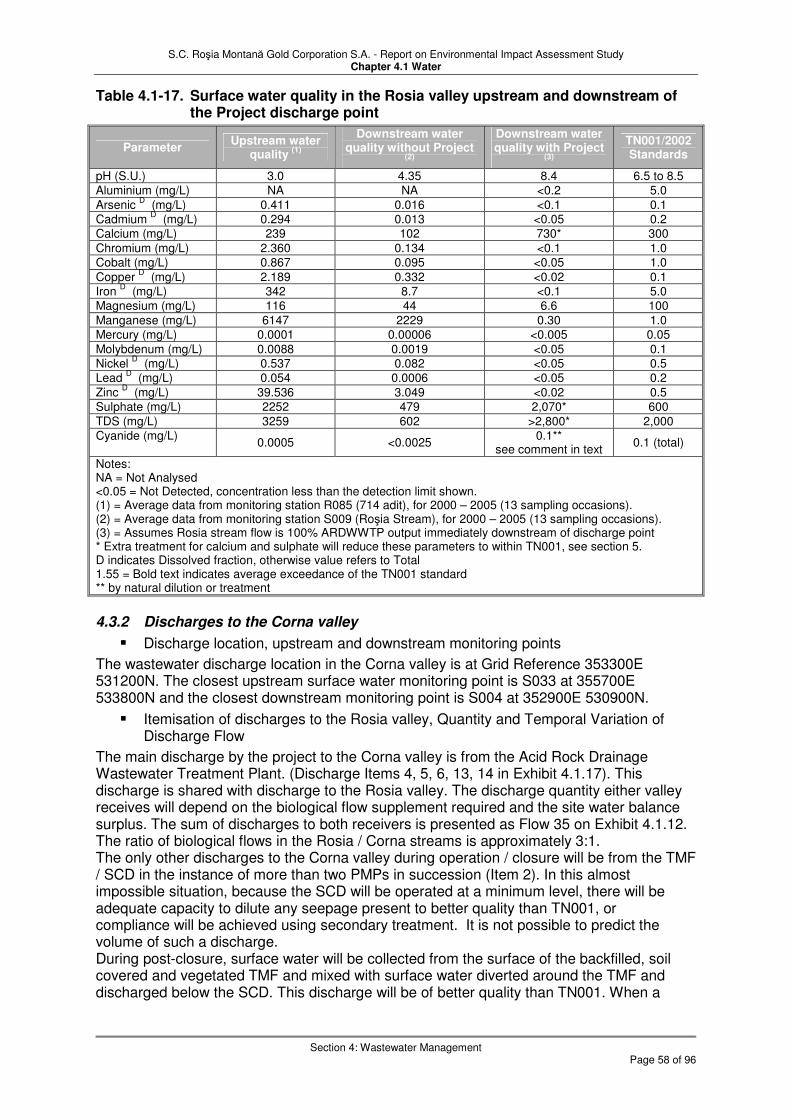
S.C. Roşia Montană Gold Corporation S.A. - Report on Environmental Impact Assessment Study Chapter 4.1 Water
Section 4: Wastewater Management
Page 58 of 96
Table 4.1-17. Surface water quality in the Rosia valley upstream and downstream of the Project discharge point
Parameter Upstream water
quality (1)
Downstream water quality without Project
(2)
Downstream water quality with Project
(3)
TN001/2002 Standards
pH (S.U.) 3.0 4.35 8.4 6.5 to 8.5 Aluminium (mg/L) NA NA <0.2 5.0
Arsenic D (mg/L) 0.411 0.016 <0.1 0.1
Cadmium D (mg/L) 0.294 0.013 <0.05 0.2
Calcium (mg/L) 239 102 730* 300
Chromium (mg/L) 2.360 0.134 <0.1 1.0
Cobalt (mg/L) 0.867 0.095 <0.05 1.0
Copper D (mg/L) 2.189 0.332 <0.02 0.1
Iron D (mg/L) 342 8.7 <0.1 5.0
Magnesium (mg/L) 116 44 6.6 100
Manganese (mg/L) 6147 2229 0.30 1.0 Mercury (mg/L) 0.0001 0.00006 <0.005 0.05
Molybdenum (mg/L) 0.0088 0.0019 <0.05 0.1 Nickel
D (mg/L) 0.537 0.082 <0.05 0.5
Lead D (mg/L) 0.054 0.0006 <0.05 0.2
Zinc D (mg/L) 39.536 3.049 <0.02 0.5
Sulphate (mg/L) 2252 479 2,070* 600
TDS (mg/L) 3259 602 >2,800* 2,000 Cyanide (mg/L)
0.0005 <0.0025 0.1**
see comment in text 0.1 (total)
Notes: NA = Not Analysed <0.05 = Not Detected, concentration less than the detection limit shown. (1) = Average data from monitoring station R085 (714 adit), for 2000 – 2005 (13 sampling occasions). (2) = Average data from monitoring station S009 (Roşia Stream), for 2000 – 2005 (13 sampling occasions). (3) = Assumes Rosia stream flow is 100% ARDWWTP output immediately downstream of discharge point * Extra treatment for calcium and sulphate will reduce these parameters to within TN001, see section 5. D indicates Dissolved fraction, otherwise value refers to Total 1.55 = Bold text indicates average exceedance of the TN001 standard ** by natural dilution or treatment
4.3.2 Discharges to the Corna valley
� Discharge location, upstream and downstream monitoring points
The wastewater discharge location in the Corna valley is at Grid Reference 353300E 531200N. The closest upstream surface water monitoring point is S033 at 355700E 533800N and the closest downstream monitoring point is S004 at 352900E 530900N.
� Itemisation of discharges to the Rosia valley, Quantity and Temporal Variation of Discharge Flow
The main discharge by the project to the Corna valley is from the Acid Rock Drainage Wastewater Treatment Plant. (Discharge Items 4, 5, 6, 13, 14 in Exhibit 4.1.17). This discharge is shared with discharge to the Rosia valley. The discharge quantity either valley receives will depend on the biological flow supplement required and the site water balance surplus. The sum of discharges to both receivers is presented as Flow 35 on Exhibit 4.1.12. The ratio of biological flows in the Rosia / Corna streams is approximately 3:1. The only other discharges to the Corna valley during operation / closure will be from the TMF / SCD in the instance of more than two PMPs in succession (Item 2). In this almost impossible situation, because the SCD will be operated at a minimum level, there will be adequate capacity to dilute any seepage present to better quality than TN001, or compliance will be achieved using secondary treatment. It is not possible to predict the volume of such a discharge. During post-closure, surface water will be collected from the surface of the backfilled, soil covered and vegetated TMF and mixed with surface water diverted around the TMF and discharged below the SCD. This discharge will be of better quality than TN001. When a

S.C. Roşia Montană Gold Corporation S.A. - Report on Environmental Impact Assessment Study Chapter 4.1 Water
Section 4: Wastewater Management
Page 59 of 96
storm occurs during post-closure, because the SCD will be operated at a minimum level, seepage collected in the SCD, should it overspill, will be diluted to better quality than TN001. Discharge of TMF seepage during post-closure will be via passive treatment cells which will remove contaminants, particularly cyanides, cyanide/sulphocyanate decompostion products ammonia, nitrates and nitrites. All quality parameters will be reduced to within TN001 except for calcium and sulphate. The relative significance of discharging these two parameters to the environment is discussed later in this section.
� Quality pre Treatment and Quality of Discharge Wastewater
The quality of treated Acid Rock Drainage wastewater discharge to the Corna valley has been discussed above. Water quality before and after treatment by the cyanide detox plant is shown in Table 4.1-18. The quality of water contained in the TMF will improve slightly relative to that shown in Table 4.1-18 as dilution with rainwater / runoff and degradation occurs within the TMF. An improvement to between approximately 30% and 70% (depending on the season) of the levels shown in Table 4.1-18 is expected. The cyanide detox process produces an increase in calcium and sulphate and a slight increase in molybdenum and arsenic. The only other substances found in concentrations above the TN001 standard in the TMF decant pond are cyanide and ammonia. Modelling indicates that seepage water of this composition would reach the SCD after around 10 years of operation. The only situations in which water from this source could be discharged to the Corna valley is during storm events of greater than two consecutive PMPs, in the event of which, dilution to within TN001 would occur, assisted if necessary by the secondary cyanide treatment plant.

S.C. Roşia Montană Gold Corporation S.A. - Report on Environmental Impact Assessment Study Chapter 4.1 Water
Section 4: Wastewater Management
Page 60 of 96
Table 4.1-18. Elemental scan of detoxification effluent from sample testing
(From: Tailings Management Facility Geochemistry and Water Quality Report Engineering Review Report Appendix F)
Pre-detox samples Post-detox samples Analyte
RM1 RM2 RM3 RM1 RM2 RM3 TN001
Standard
Total Cyanide 183 189 181 1.13 5.09 3.29 0.1 WAD Cyanide 182 187 177 0.37 0.77 0.22 ---
Thiocyanate 39 37 57 70 69 91 --- Cyanate 110 110 30 390 390 350 ---
Thiosalts 10 14 12 <2 <2 2.50 --- Ammonia - - - 6.6 7.3 25 2 Gold 0.0039 0.0045 0.003 0.0085 0.043 0.0165 ---
Silver 0.135 0.041 <0.02 <0.05 <0.05 <0.05 0.1 Aluminium 0.2 0.60 1.0 <0.2 0.20 0.20 5
Arsenic <0.1 <0.1 <0.05 0.30 <0.2 0.20 0.1 Boron <0.2 <0.2 <0.2 0.20 0.20 0.40 ---
Barium <0.01 0.08 0.05 <0.05 <0.05 <0.05 --- Beryllium <0.001 <0.001 <0.01 <0.02 <0.05 <0.02 --- Bismuth <0.001 <0.001 <0.01 <0.02 <0.02 <0.02 ---
Calcium 120 416 484 401 675 707 300
Cadmium <0.01 0.01 <0.05 <0.5 <0.1 <0.5 0.2
Cobalt 0.20 0.30 0.80 0.40 0.40 0.80 1 Chromium <0.2 <0.2 <0.2 <0.2 <0.2 <0.2 1 Copper 40.3 20.9 21.9 0.10 0.10 0.10 0.1
Iron 1.40 0.60 1.20 0.20 1.4 1.0 5 Mercury <0.001 2 <0.01 <0.01 <0.01 <0.01 0.05
Potassium 110 102 96 142 136 132 --- Magnesium 7.00 2.00 3.6 5.4 14.4 8.2 100
Manganese <0.1 <0.1 <0.1 0.30 0.80 <0.1 1
Molybdenum 0.26 0.19 0.3 0.4 0.3 0.4 0.1
Sodium 413 383 390 725 900 705 ---
Nickel 0.60 <0.2 0.4 0.20 0.40 0.20 0.5
Phosphorus <5 <5 <5 <1 <0.5 <1 ---
Lead <0.05 <0.05 <0.5 <1 <1 <1 0.2
Rubidium 0.286 0.367 .04 0.35 0.35 0.50 --- Sulphur 210 460 490 660 1030 962 ---
Sulphate(1)
630 1380 1470 1980 3090 2886 600 Antimony 0.24 0.190 0.02 0.00 0.28 0.06 ---
Selenium <0.1 <0.1 <0.5 <5 <5 <5 0.1 Silicon 6.00 4 2 8 6 8 --- Tin <0.02 <0.02 <0.1 <0.2 <0.2 <0.2 ---
Strontium 0.96 2.46 2.2 1.4 2.1 2.1 ---
Zinc 6.00 5.8 11.4 <0.2 <0.1 <0.2 0.5
Notes: All units in mg/L Bold = exceedance of TN001 Italics = detection limit > TN001 (1) = calculated assuming all sulphur as sulphate Many of the rarer elements were also analysed with the above suite, but all were below detection limit before and after the detoxification process
Samples RM1-RM3 are from pilot scale testwork – with respect to WAD cyanide, at an industrial scale these post-detox figures may not be achieved. The Project assumes conservatively only that the EU Mine Waste Directive limit of 10 mg/L WAD CN will be met, although actual performance may be better in practice. Leaching of tailings representative of those in the TMF indicated that there was very little potential to generate ARD. ARD generated by the TMF dam face (Item 6) will be pumped to the ARD Waste Water Treatment Plant as described in the previous section.

S.C. Roşia Montană Gold Corporation S.A. - Report on Environmental Impact Assessment Study Chapter 4.1 Water
Section 4: Wastewater Management
Page 61 of 96
� Quality of receiver upstream and downstream of the discharge point
The surface water quality upstream of the project discharge in the Corna valley (sample point S033) together with the downstream quality (sample point S004) with and without the project discharge is shown in Table 4.1-19. It should be noted that using sampling point S004 as representative of the surface water quality downstream of the Project discharge in Corna valley is rather conservative. Considerable dilution of the Corna stream has occurred before S004 is reached. Even so, the improvement to surface water quality caused by the main Project discharge to the Corna valley is apparent, with a general reduction in the level of all parameters to below TN001. Calcium and sulphate (and, as a result, TDS) and the slight exceedances for molybdenum and arsenic will be dealt with by secondary treatment by pumping from the SCD to the ARD Waste Water Treatment Plant. In the event of more than two PMPs occuring in succession, concentrations of these parameters would be reduced to within TN001, by dilution or secondary treatment.
Table 4.1-19. Surface water quality in the Corna valley upstream and downstream of the Project discharge point
Parameter Upstream water
quality (1)
Downstream water quality without
Project (2)
Downstream water quality with
Project post-ARDWWTP
(3)
Downstream water quality with Project post-detox
plant(4)
pH (S.U.) 2.79 7.06 8.4 see text on pH Aluminium (mg/L) - - <0.2 0.2
Arsenic D (mg/L) 0.068 0.00977 <0.1 0.25(T)
Cadmium D (mg/L) 0.048 0.00291 <0.05 <0.1
Calcium (mg/L) 272 72.4 730* 594*
Chromium (mg/L) 0.279 0.0013 <0.1 <0.2
Cobalt (mg/L) 0.027 0.0045 <0.05 0.53
Copper D (mg/L) 0.624 0.082 <0.02 0.1(T)
Iron D (mg/L) 60 1.31 <0.1 0.87(T)
Magnesium (mg/L) 32 12.9 6.6 9.33 Manganese (mg/L) 5399 116 0.30 0.55 Mercury (mg/L) 0.00007 <0.00001 <0.005 <0.01
Molybdenum (mg/L) 0.002 0.0003 <0.05 0.37
Nickel D (mg/L) 0.036 0.0048 <0.05 0.26(T)
Lead D (mg/L) 0.006 0.0024 <0.05 <1(T)
Zinc D (mg/L) 1.263 0.0081 <0.02 <0.15(T)
Sulphate (mg/L) 1057 133 2,070* 2652*
TDS (mg/L) 1586 317 >2,800* - Cyanide (mg/L)
<0.0025 <0.0025 0.1
see text on CN 3.17 **
Notes: NA = Not Analysed <0.05 = Not Detected, concentration less than the detection limit shown. (1) = Average data from monitoring station S033 for 2000 – 2005 (13 sampling occasions). (2) = Average data from monitoring station S004 (Corna Stream), for 2000 – 2005 (13 sampling occasions). (3) = Assumes Corna stream flow is 100% ARDWWTP output immediately downstream of discharge point (4) = Assumes Corna stream flow is 100% detox plant output (average of samples RM1-3) immediately downstream of discharge point * Extra treatment for calcium and sulphate will reduce these parameters to within TN001, see text D indicates Dissolved fraction, otherwise value refers to Total Bold = average exceedance of the TN001 standard. Italics = detection limit > TN001 ** in industrial-scale conditions the maximum CNt concentration can be 15 mg/L; by degradation/attenuation the concentration can be reduced by 50%.

S.C. Roşia Montană Gold Corporation S.A. - Report on Environmental Impact Assessment Study Chapter 4.1 Water
Section 4: Wastewater Management
Page 62 of 96
4.3.3 Groundwater No extra comment regarding groundwater is included because of the lack of significant aquifers in the area except for the thin strips of alluvium that are in hydraulic continuity with the surface water. It is considered that all groundwater in the Rosia and Corna catchments reports to the surface streams, even if via adits. Groundwater discharge from via seepage from the Cetate Pond, Flow 42, Exhibit 4.1.12 is expected to be nil. The seepage from the Cirnic Waste Holding Pond will report to the TMF. 4.3.4 Monitoring Apart from daily monitoring of the effluent at the treatment plant, TMF and Cetate pond described in Section 8 (and Chapter 6) it is suggested that sampling and analysis is carried out in the Rosia and Corna valleys:
� In the discharge line immediately prior to discharge,
� In the stream immediately above the discharge and
� In the stream immediately downstream of the discharge
on a monthly basis for the parameters listed in Table 4.1-19. Flows should also be measured and reported. Monthly monitoring for the same parameters at R085, S009, S033 and S004 is also recommended, and that a monthly factual report comparing the findings with the standards be submitted to the appropriate authorities. 4.3.5 Summary
� Wastewater Management
Four types of water; process water, acid rock drainage wastewater, storm water runoff impacted by past and project mining activites and domestic wastewater. Three treatment process handle these waters; cyanide detoxification for the process water with post-TMF contingency cyanide treatment if necessary, ARD wastewater treatment including treatment for calcium and sulphate, and domestic wastewater treatment. Two discharge points receive the final discharges from the Project, located in the Rosia valley downstream of the Cetate Dam and in the Corna valley downstream of the Secondary Containment Dam. The TMF is a closed system and permits no discharge to the environment up to two consecutive PMP’s. There are no process water flows during the construction and closure phases of the Project. 80% of the water entering the TMF will be reused. Acid Rock Drainage includes existing ARD which will be stored behind the Cetate Dam with Project generated ARD and treated. Wastewater from the ARD treatment will also be used. Quantities are given in Exhibit 4.1.12. The Domestic Wastewater Treatment Plant will receive and treat domestic wastewater collected from the staff facilities in the plant area. Mining impacted storm water will be captured in the TMF, the plant storm water pond and in the Cetate Dam. Unimpacted storm water will be diverted around the containment structures to the Rosia and Corna streams via storm water diversion channels.
� Discharge to the Environment
The main discharge by the project to the Rosia Valley is from the Acid Rock Drainage Wastewater Treatment Plant. The only other discharge will be the in the instance of a storm of greater than 1 in 100 year 24-hour event in the Rosia catchment. There will be a significant improvement to surface water quality caused by the main Project discharge to the Rosia valley, with an improvement of water quality for all measured parameters, particularly metals and pH. All discharges will thus be to within TN001 standard with the possible exception of a slight exceedance with respect to pH during a 24 hour storm greater than 1 in 100 year. The main discharge by the project to the Corna Valley is from the Acid Rock Drainage Wastewater Treatment Plant. The only other discharges to the Corna valley during operation / closure will be from the TMF / SCD in the instance of more than two PMP’s in succession.

S.C. Roşia Montană Gold Corporation S.A. - Report on Environmental Impact Assessment Study Chapter 4.1 Water
Section 4: Wastewater Management
Page 63 of 96
The cyanide detox process produces an increase in calcium and sulphate and a slight increase in molybdenum and arsenic. The only other substances found in concentrations above the TN001 standard in the TMF decant pond are cyanide and ammonia. In the event of more than two PMP’s occuring in succession, concentrations of these parameters would be reduced to within TN001 by natural dilution or treatment in contingency cyanide treatment plant. There will be a significant improvement to surface water quality caused by the main Project discharge to the Corna valley with a reduction in the level of all parameters to below TN001.

S.C. Roşia Montană Gold Corporation S.A. - Report on Environmental Impact Assessment Study Chapter 4.1 Water
Section 5: Potential Project Impacts
Page 64 of 96
5 Potential Project Impacts
5.1 Introduction
This section describes the sources of potential negative environmental impact that are present due to the nature of a gold mining facility. Just because they exist, these sources are not necessarily realised – in general they are mitigated by a range of measures described in the following section 6. Residual impacts remaining in respect of these sources following these mitigation measures are described in section 7. Summary mitigation measures are also included in the impact/mitigation table in section 6.6. In the absence of mitigation measures by the project, the following project impacts could occur:
5.2 Physical Impacts
As a result of Project implementation, the following physical impacts on the aquatic environment are potentially possible: 5.2.1 Release of impacted sediments and suspended solids The level of land disturbance as a result of Project implementation has the potential to increase the sediment loading, especially during storm events, and thereby increase the total suspended solids concentrations in receiving streams. This potential is particularly relevant during the construction phase, but will continue through operation and into closure. 5.2.2 Reduced surface water flows Impacts to surface water flows will occur due to direct interception and containment of contaminated and uncontaminated surface water flows by structures constructed during the implementation of the Project. These structures include the Cetate Water Catchment Dam and the mine pits, with their associated diversion channels in the Rosia Valley; and the TMF and SCD with their associated diversion channels in the Corna Valley. Further drainage will be diverted from waste rock dumps in both valleys, from the old mine wastes and low grade ore stockpile and the 714 adit in the Rosia Valley from the operations area. The net result will be the potential to impact the flows in the Rosia and Corna streams and therefore also the Abrud and ultimately the Aries rivers. Wherever possible, clean water will be diverted around the facilities to the respective catchments downstream of the Project area, without loss of flow – and so any residual impact on surface water flows in the downstream system will be mainly in respect of loss of contaminated water only. 5.2.3 Pit dewatering During mining groundwater is expected to be encountered at an elevation of around 714 m ASL (714 adit). When the pit bottoms are excavated below this level, groundwater is expected to start draining into the pits, including possibly some reverse drainage from the current mine adits. Prolonged pit dewatering operations may result in groundwater drawdown leading to reduced groundwater contributions to surface water flows in the Roşia Valley where the pits are located. 5.2.4 Water abstraction The proposed Project is planning to use the raw water from the Arieş River as a main water supply source. This will reduce flows in the Arieş River. The area between the proposed Project intake and the Abrud confluence will potentially be the most impacted.

S.C. Roşia Montană Gold Corporation S.A. - Report on Environmental Impact Assessment Study Chapter 4.1 Water
Section 5: Potential Project Impacts
Page 65 of 96
5.3 Chemical Impacts
As a result of Project implementation, the following chemical impacts on the aquatic environment are potentially possible: 5.3.1 Cyanide Cyanide will be introduced to the Project area for use in the gold extraction process. It will be present as cyanide brickettes in the process area prior to gold extraction and at around 180 to 190 mg/L total cyanide in the tailings prior to detoxification (Table 4.1-18). Although cyanide concentrations are reduced by the mitigating measure of detoxification (see Section 6) cyanide will continue to be present in the TMF and the tailings pipeline at 1 to 5 mg/L total cyanide (0.22 to 0.77 mg/L WAD cyanide, Table 4.1-18), but lower than the EU Mine Waste Directive limit of 10 mg/L WAD CN. Failure of the detoxification process would result in untreated concentrations, that is baseline concentrations, entering the TMF (but not the water environment), although in the event of process failure pumping to the TMF would be halted. 5.3.2 Cyanide detoxification byproducts The cyanide detox process produces an increase in calcium in the process water to between 400 and 700 mg/L and and in sulphate between 2000 and 3000 mg/L (Table 4.1-18). There is also a slight increase in molybdenum to concentrations of 0.3 to 0.4 mg/L and of arsenic to concentrations of 0.2 to 0.3 mg/L. Failure of the TMF could potentially result in these substances entering the aquatic environment at these concentrations. The only other substance likely to occur in concentrations above the TN001 standard in the tailings (and thereby constraining the ability to discharge without further mitigation) is ammonia produced by the dissociation of cyanide. Concentrations of 6.6 to 25 mg/L ammonia are predicted (Table 4.1-18). 5.3.3 Acid Rock Drainage In the Corna valley and particularly the Rosia valley, the impact on the aquatic environment of an unintentional discharge of ARD due to failure of any of the structures or the wastewater treatment would result in a return to the baseline (or similar) concentrations of hydrochemical parameters (Table 4.1-17). An accidental release of this water without treatment is therefore not considered to be a negative Project impact, rather a reduction in the positive Project impact resulting from the wastewater treatment. 5.3.4 Domestic wastewater There is a potential impact by the Project on the aquatic environment by the release of domestic wastewater. This could occur during the construction phase from the construction camp or the portable facilities in outlying areas or during the operation phase should failure of the mitigating treatment occur.
5.4 Positive Impacts
The main Project influence on the water environment is a positive one, in that the extensive water treatment measures incorporated in the design of the Project, which include interception and treatment of ARD-contaminated waters that are already present, will result in an improvement to water quality downstream in the Roşia, Corna, Abrud and Arieş valleys. Releases from the Project, rather than the currently uncontrolled contaminated surface drainages, will only occur in compliance with the NTPA 2005/001 discharge standards. In the absence of the Project (the zero alternative), the current situation will continue. Furthermore, the physical water management of the Project will also improve ecological conditions by
� Reducing levels of suspended solids in the river systems; and

S.C. Roşia Montană Gold Corporation S.A. - Report on Environmental Impact Assessment Study Chapter 4.1 Water
Section 5: Potential Project Impacts
Page 66 of 96
� Maintaining minimum biological flows in the Roşia and Corna valleys, especially important during periods of drought.
Residual impacts (including positive impacts) are described further in Section 7.

S.C. Roşia Montană Gold Corporation S.A. - Report on Environmental Impact Assessment Study Chapter 4.1 Water
Section 6: Mitigation
Page 67 of 96
6 Mitigation
6.1 Introduction
Previous sections in Chapter 4.1 have addressed the hydrological baseline condition for the Project (Section 2), the issues of water supply (Section 3) and wastewater discharge (Section 4) in accordance with the Romanian terms of reference, and the sources of potential water-related impact arising from the Project Section 5). This Section (Section 6) describes and assesses the mitigation measures developed by the Project to address the impacts identified in Section 5, either as part of its fundamental design or in order to minimise or eliminate negative impacts. In essence these mitigation measures comprise physical water management combined with water treatment, and result in an operation which:
� Minimises consumption of natural water resources;
� Allows releases to the outside water environment only under controlled conditions in order to ensure regulatory compliance and minimise negative impacts; and
� Incorporates existing contaminating discharges in Roşia Montana into the water management and treatment regime so that the actual impact on the outside water environment is positive (i.e. an improvement) compared to the zero alternative of the Project not taking place at all.
The following subsections in Section 6 consider:
� The overall water management strategy;
� The site water balance model developed to confirm that the water management strategy can be realised under a range of normal operating conditions (extreme events are considered outside of the model, taking consideration of event magnitudes and water management infrastructure design criteria);
� Wastewater treatment measures (in summary only – details are contained in Chapter 2);
� Analysis of emergencies and risk of catastrophic events (such as dam failure) together with associated procedures (in summary only – details are contained in Chapter 8.
Section 6 concludes with presentation of a summary water impact and mitigation table. In Section 7 (Residual impacts) data are presented describing the projected changes in condition of the receiving water environment over time which would result from the Project and its mitigation measures. These mitigation measures address not only its own impacts but those historical impacts which would otherwise remain and continue to contaminate the downstream water environment.
6.2 Water Management Strategy
6.2.1 Introduction The water management strategy defines the means by which the Project consumes, uses and discharges water in a manner that minimises environmental impact and enables Project operations to proceed as efficiently as possible. The key objectives for the water management strategy are to meet all relevant Romanian and EU regulations and to comply with other international (e.g. World Bank) guidelines. In addition, the strategy needs to consider the following:
� Providing sufficient water for process operations, while at the same time minimising fresh water requirements;
� Maintaining biological baseflows in Corna and Roşia streams;

S.C. Roşia Montană Gold Corporation S.A. - Report on Environmental Impact Assessment Study Chapter 4.1 Water
Section 6: Mitigation
Page 68 of 96
� Keeping clean water and contact water separate as far as possible;
� Ensuring water meets appropriate standards prior to any release;
� Providing storage for two PMF probable maximum flood (PMF) events in the tailings management facility (TMF); and
� Providing options for treatment of low concentrations of cyanide during temporary cessation and closure, including water transferred from the Corna Valley to the mine pit system, and for any period when water discharge may be needed to correct a surplus in the water balance.
During the evolution of the Project a number of water management strategies were considered and evaluated. Whilst they all met the requirement for efficient Project operation, and at a range of costs, in many cases this came at the expense of complete environmental compliance. These strategies were therefore eliminated from consideration, but are summarised in Chapter 5 (Alternatives) to illustrate the range of options considered by the Project. The preferred option is described below. Fuller details of the management of each aspect of the water management infrastructure are contained in the Water Management and Erosion Control Plan and, with respect to closure (including temporary cessation) and post-closure, in the Mine Rehabilitation and Closure Management Plan. 6.2.2 Drainage diversion The primary receiving streams for unimpacted water will be the Roşia Stream and Corna Stream. The North and South Storm Water Diversions at the TMF will both discharge into Corna Valley immediately downstream of the Secondary Containment System. The Northern Roşia Valley Diversion Channel extending from the northern flank of the valley will discharge into Roşia Stream immediately downstream of the Cetate Water Catchment Dam and Pond. The diversion channels will be constructed during the construction phase to minimise the volume of clean surface water entering disturbed areas of the site. These diversion channels will be intended to convey water that is not impacted by historical or proposed mining activities. The diversions will reduce the volume of clean water and storm water mixing with possibly site-impacted waters requiring treatment in the mine area, thus reducing the overall treatment requirements and helping to provide for the biological baseflows in downstream streams. An additional objective of the diversions includes protecting structures, stockpiles and active areas from flood flows. The primary diversion structure in the Roşia Valley will be constructed on the northern flank of the valley (Figure 4.1.12). The unimpacted water carried in the diversion will bypass around the Cetate Water Catchment Dam and Pond, and it will provide both the baseflow in the Roşia Valley downstream of the Cetate Water Catchment dam and reduce the acid rock drainage treatment requirements. The Northern Diversion channel will start at the intake weir and will discharge at the Cetate dam spillway downstream of the spillway sill. The northern diversion channel is designed as a permanent concrete-lined structure with a number of lateral spillways that will allow a controlled overflow of water into the Cetate Water Catchment Dam and Pond during events that exceed the channel design capacity. The other diversion channels are temporary features. Their location during various phases of development is shown on Exhibits 2.3 to 2.9 in Chapter 2, Technological Processes. Based on the optimisation of the channel capacity compared to the Cetate dam height, the northern diversion channel is designed preliminarily for a flow capacity of 18,000 and 28,800 m3/hr at the channel intake and the channel discharge outlet, respectively. The flows in excess of the channel capacity will overflow into the Cetate Water Catchment Dam and Pond during the operational period. This is achieved by limiting the channel inflow at the weir intake and providing lateral spillways along the channel. In order to minimise erosion, the channel lateral spillways will be located at the existing Roşia Valley right-bank tributaries and gullies. An important modification to the Northern Diversion Channel will occur in Year 7 of the operation. The channel will be extended to include the Orlea and Jig pit areas. This extension will impact the amount of water entering the Cetate Water Catchment Pond and

S.C. Roşia Montană Gold Corporation S.A. - Report on Environmental Impact Assessment Study Chapter 4.1 Water
Section 6: Mitigation
Page 69 of 96
acid rock drainage treatment needs will increase. In the closure phase, the diversion will remain in place with possible modification. This is needed to route clean water away from the Orlea and Jig mine pits. In the Corna Valley, diversion works will be constructed to minimise the volume of clean water that would enter the TMF and occupy capacity that will otherwise be reserved for tailing storage. The North and the South Diversion Channels will be constructed to collect and route unimpacted water from the hillsides around the TMF and Secondary Containment System. The diversion channel located northwest of the TMF is designed to capture flow from higher areas and convey these flows to the Corna Valley downstream of the Secondary Containment System. The southeastern diversion channel will be constructed to collect unimpacted storm water from hillsides southeast of the TMF and the Secondary Containment System and route these flows to Corna Valley as well. The location of these channels during various phases of development is shown on Exhibits 2.3 to 2.9 in Chapter 2. Technological Processes. Other than the Northern Diversion channel in the Roşia Valley, the diversion channels will not be 100% efficient in routing storm water since the channels will be of earthen construction. The engineering design criteria assume that two-thirds of the flow reaching the channels will be collected in them and diverted. Storm water downstream (down-slope) of the channels is not intercepted and, in the case of the diversion channels located near the TMF, will mix with water stored in the TMF. In post-closure, all excess rainfall on the closed and covered TMF will be collected at the lowest point of the reprofiled run off and directed via a reprofiled drainage diversion system to a point below the TMF dam. 6.2.3 Water management strategy outline Exhibit 4.1.18 illustrates graphically the elements which form the basis of the water management strategy. A key component of the strategy is the additional treatment of Project wastewater to enable water discharged from the Waste Water Treatment (ARD) Plant to also meet the requirements of NTPA 001/2005 (TN001) standards. This requires an additional treatment step to be added to the ARD treatment process (summarised in sub-section 6.5 and described in detail in Chapter 2). Water supply and waste water discharge have already been described and discussed in Sections 3 and 4 respectively. The following water management conditions for the Corna and Roşia Drainage Basins were considered:
� Normal operating conditions (NOC);
� Extreme events (up to and including Probable Maximum Precipitation [PMP]);
� Temporary cessation;
� Closure; and
� Post-closure.
Each of these conditions is summarised below for the Corna and Roşia drainage basins. 6.2.3.1 Normal Operating Conditions The normal operating conditions will include all periods where the mining and processing operations are active and excluding storm event conditions. The NOC period will transition into the closure period over a number of years due to the concurrent/early closure of some facilities, and may be interrupted by one or more periods of temporary cessation. The Normal Operating Conditions are illustrated graphically in Exhibit 4.1.19. a) Corna Basin
� Seepage from the Tailings Management Facility (TMF) will be collected by the seepage collection system, which at its downstream point includes the Secondary Containment Dam (SCD) pond. This pond is actually a sump that will be used to depress the groundwater table and will act as a hydraulic sink.

S.C. Roşia Montană Gold Corporation S.A. - Report on Environmental Impact Assessment Study Chapter 4.1 Water
Section 6: Mitigation
Page 70 of 96
� A line of three to five monitoring wells will be installed downstream of the SCD to confirm by monitoring that the TMF water is being contained by the seepage collection system. If TMF components are ever detected in the monitoring wells, groundwater recovery using wells will become a component of the seepage collection system.
� Seepage water from the SCD pond (and/or recovery wells) will be pumped back to the reclaim pond for recycling in the process.
� The process plant tailings discharge is expected to contain less than 10 mg/L WAD cyanide, in accordance with the EU Mine Waste Directive. Natural degradation of cyanide will occur in the TMF further reducing the concentration in the reclaim/decant pond and to a lesser degree in the pore spaces of the tailings mass.
� Runoff and seepage from the Cirnic Waste Rock dump will be allow to flow into the TMF if the water quality is not significantly impacted by Acid Rock Drainage (ARD). If impacted by ARD, the seepage and runoff will be captured and pumped the ARD treatment plant.
� Biological baseflow requirements will be maintained using treated water from the ARD treatment plant that meets the TN001 standards, and/or water from the freshwater system, as needed.
� A contingency treatment system will be constructed during the operational period to treat any water containing low concentrations of cyanide in order to meet existing TN001 cyanide standards (0.1 mg/L total cyanide). This system will be in place so that a surplus of cyanide-containing water in the water balance could be treated and discharged. Such a discharge would likely also have to treated for sulphate and total dissolved solids (TDS) and would therefore need to be commingled with the Rosia ARD treatment plant inflow.
b) Rosia Basin
� The ARD treatment system will include secondary treatment (see Section 4.2.2.2 and Chapter 2) to reduce concentrations of sulphate and TDS below TN001 requirements for these parameters.
� Calcium has also been identified as a potential water quality concern for discharge from the ARD treatment plant. However, this concern can be addressed by optimization of the ARD treatment process to facilitate precipitation of excess calcium in the process. This is effectively implemented in many ARD treatment plants.
� All runoff water from the waste rock, open pits, low-grade ore stockpile, or the 714 Adit will be collected behind the Cetate dam and pumped to ARD treatment plant.
� No cyanide-containing wastewater will normally be managed in the Rosia Basin. During or after extreme precipitation events the reclaim pond may need to be reduced in size. In this case, cyanide-containing water may be treated to TN001 standards in the secondary cyamnide waste water treatment plant and discharged.
� Discharge to Rosia Stream will be in compliance with TN001. This discharge will be used to help maintain the project water balance and to supplement the biological baseflow in Rosia Stream when needed.
c) Waste rock seepage � The main conclusion relevant to the waste rock seepage quality predictions drawn
from the geochemical testing program is that it is likely to have the characteristics of a neutralised ARD, with neutral pH, low concentrations of heavy metals but elevated contents of Sulphate, Calcium, Magnesium and TDS. It is expected to be similar to the Cetate waste dump seepage.

S.C. Roşia Montană Gold Corporation S.A. - Report on Environmental Impact Assessment Study Chapter 4.1 Water
Section 6: Mitigation
Page 71 of 96
� In the operations phase, when more statistically relevant waste rock samples become available, the predictions for the chemical composition of the waste rock seepage will be continuously updated.
d) TMF dam seepage It is assumed that the TMF dam seepage water collected at the Secondary Containment Dam in the Corna valley will have the same compositions as the decant water. This assumption is very conservative having regard to the following considerations:
� Heavy metals and metalloids such as arsenic are very likely to be retarded (mainly by adsorption on the tailings and soil particles in the dam and underground); and,
� Cyanide will naturally degrade (by 30 – 70% depending on season), given the long migration time through the tailings body.
6.2.3.2 Extreme Event Conditions Storm events are defined in Table 4.1-3 and individual design criteria for water management infrastructure components are contained in the Water Management and Erosion Control Plan. Water from most storm conditions will be contained and treated. However, certain extreme events that have a very low probability of occurring during the project life may result in discharges to the Corna and Rosia basins. These conditions are discussed below. a) Corna Basin
� The SCD pond/sump will be operated a very low levels due to the necessity of maintaining a hydraulic sink.
� During a storm event there will be sufficient dilution in the SCD Pond for cyanide and other TMF constituents to allow a spillway discharge to the Corna stream and while meeting the TN001 standards. This calculation has been done using a conservative assumption that the seepage will resemble the TMF decant pond quality. Actually, seepage attenuation will likely result in lower concentrations in the SCD pond.
� The TMF dam will provide containment of runoff from the entire drainage basin for two Probable Maximum Floods (PMFs) (2.7M m3). In the unlikely event that this should occur, drainage of the excess water will take place via the secondary cyanide waste water treatment plant.
� Unimpacted runoff from the Cirnic waste rock stockpile will be allowed to flow into the TMF. If impacted by ARD, the runoff will be pumped to and treated at the ARD plant. If the Cirnic storm water exceeds the capacity of the collection pond or ditches, it will flow into the TMF. This flow is accounted for in the PMF calculation.
b) Rosia Basin
� Cetate pond levels will be operated at sufficiently low levels to allow storm water runoff to provide dilution to meet TN001 standards, except with the possible exception of pH. As a mitigation measure, the spillway and Cetate dam face will be constructed with limestone.
� The ARD treatment plant will continue to operate and discharge as during normal operating conditions (NOC). It is presumed that this plant will be operated at a maximum rate to reduce storm water storage in the water management system. This may necessitate utilisation of the secondary cyanide treatment to reduce the volume of process water in the system.
6.2.3.3 Temporary Cessation Temporary cessation could potentially occur if for any reason the project ceases operation and moves to a care and maintenance state with the anticipation of restarting. The care and maintenance state could last for a few months to several years. The Temporary Cessation Conditions are illustrated graphically in Exhibit 4.1.20.
S.C. Roşia Montană Gold Corporation S.A. - Report on Environmental Impact Assessment Study Chapter 4.1 Water
Section 6: Mitigation
Page 72 of 96
a) Corna Basin
� Recycling of water from the reclaim pond will stop. The reclaim pond will then grow due to a positive water balance. However, due to a large reserve storage capacity, there will be excess capacity in the reclaim pond above that required for extreme storm events. The amount of excess capacity will depend upon the stage of the Project and required storm capacity storage.
� Once the excess capacity is filled in the pond, water would have to be treated to TN001 standards in the secondary cynaide waster water treatment plant and discharged.
� Seepage collected in the SCD pond will continue to be pumped to the reclaim pond.
� The ARD treatment plant will be available to correct the water balance, if needed.
� Seepage and runoff from the Cirnic waste rock stockpile will be allowed to flow to the TMF unless the water quality would impact restart of the process. In this case, the runoff and seepage would be pumped to the ARD treatment plant.
b) Rosia Basin
� Management of water in the Rosia Basin will be the same as NOC. However, depending upon the stage of the project additional water storage capacity may be available in the mine pits. This may allow for some additional flexibility in water management.
6.2.3.4 Closure The closure phase will occur progressively during the final years of operation to several years after all mineral processing has stopped. Active mining in the Rosia Basin will end three years before the cessation of processing and tailings deposition in the Corna Basin. The Closure Conditions are illustrated graphically in Exhibit 4.1.21. a) Corna Basin
� Immediately after processing ends, the cyanide concentrations in the reclaim pond will drop due to natural degradation. Once levels are reduced to below 0.1 mg/L total cyanide, either by natural degradation or by treatment in the secondary cyanide waste water treatment plant, the water can be pumped to the pits to facilitate pit lake formation. However, this needs to be balanced by the need to maintain storm water capacity in the TMF.
� Seepage water in the SCD pond will continue to be pumped to the decant pond as long as it is present. Once the TMF decant pond is removed the seepage water will be pumped to the mine pits. If necessary, the water will be treated in the secondary cyanide waste water treatment plant prior to discharge to the pits. Alternatively, it may be treated in a series of treatment cells below the SCD and discharged to Corna Stream (see under post-closure below).
� Seepage from the Cirnic waste rock stockpile will be pumped to the pit lake system if impacted by ARD where it will be treated in-situ or through the ARD plant. Otherwise, the water will be allow to discharge to the Corna Basin.
b) Rosia Basin
� It is expected that the pit lake system will collect ARD from pit walls.
� Water will be allowed to accumulate in the pit lake system. In-pit water treatment will be conducted if needed and functional. All ARD water will be directed to the pit lake system or directly to the ARD treatment plant.
� Cetate pond levels will be operated at sufficiently low levels to allow storm water runoff to provide dilution to meet TN001 standards, except pH. The slight pH
S.C. Roşia Montană Gold Corporation S.A. - Report on Environmental Impact Assessment Study Chapter 4.1 Water
Section 6: Mitigation
Page 73 of 96
exceedances will be mitigated by construction of the spillway and Cetate dam face with limestone.
� While the pit lake system is filling, the requirement to discharge treated water will be reduced to that needed to supplement biological baseflow.
� If the pit lake system reaches an optimal operating level during the closure period, a discharge through the ARD plant will likely be needed. The ARD treatment plant will then operate and discharge similar to NOC.
c) Cetate Pit Lake formation
� Pit lake filling is affected by the amount of pit wall runoff that must be captured and the volume used for TMF decant water. Filling of the pit lake is expected to be rapid, which is ideal for reducing ARD generation from the pit walls. The addition of the TMF water will increase the level above the 714 adit, at which point seepage is expected to begin. This seepage will be collected by the 714 adit, downstream of the bulkhead, and be directed to the Cetate Water Catchment Pond.
� It is presumed that the 714 Adit will be bulkhead midway between the portal and its intersection with the mine pits. The downstream end of the adit will function as a vertical dewatering tunnel and collect this seepage and direct it to the mine water collection system (i.e., the Cetate Water Catchment Pond). However, it may be necessary to draw water from the 714 Adit, or by pumping the Cetate pit lake, to maintain a lower lake level and manage the seepage as long as pit lake water quality requires management.
� The exact composition of the pit lake water cannot be known at this stage; it strongly depends on the ratio between sulphidic and neutralizing minerals in the pit walls and it is likely that the pit water will need treatment when flooded.
� The water in the pit lake can be neutralized with suitable methods such as liming. This method will generate sustainable improvements in water quality if the sulphidic parts of the pit walls are sealed.
� A more detailed prediction of the pit lake quality will be possible only during the operations phase, when more statistically relevant mineralogical samples become available. This Mine Closure and Rehabilitation Management Plan and other Management Plans within the Project's ESMP will be continuously updated accordingly. However, this does not invalidate the general pit closure strategy.
6.2.3.5 Post Closure The post closure period begins once all closure construction is completed. The Post-Closure Conditions are illustrated graphically in Exhibit 4.1.22. a) Corna Basin
� The reclaim pond will no longer be present during the post-closure period.
� Surface water runoff from the basin will be routed around or off the TMF and discharged into Corna Stream below the SCD.
� Similar to other periods, the dilution would be sufficient to reduce concentrations of TMF constituents to below TN001 standards if a storm water discharge were to occur from the SCD. If residual cyanide is in excess of 0.1 mg/L total CN, this discharge will be passed through the secondary cyanide treatment plant prior to release.
� Seepage water in the SCD pond will be pumped to the pits. Alternatively, it may be treated in a series of semi-passive treatment cells below the SCD and discharged to Corna Stream.

S.C. Roşia Montană Gold Corporation S.A. - Report on Environmental Impact Assessment Study Chapter 4.1 Water
Section 6: Mitigation
Page 74 of 96
� The Cirnic waste rock stockpile will have been covered and runoff will be directed to Corna Stream. Seepage will be greatly reduced. If present in a quantity and quality that requires additional management, this water will be pumped to the mine pits.
b) Rosia Basin
� The Cetate pond will be present to collect seepage from the pit lake system and seepage from the Cetate waste rock dump. This water will be pumped back to the pit lake system or treated in the ARD treatment plant and discharged to Rosia Stream.
� The 714 Adit downstream of the bulkhead will act to intercept pit lake seepage and direct it to the Cetate pond.
� Cetate pond levels will be operated at sufficiently low levels to allow storm water runoff to provide dilution to meet TN001 standards, except pH. The slight pH exceedances will be mitigated by construction of the spillway and Cetate dam face with limestone.
� ARD treatment plant will continue to operate and discharge similar to NOC. The plant will be used to help treat the pit lake water in-situ, and when needed, provide a means to discharge pit lake water to Rosia Stream while meeting TN001 standards.
� In pit treatment will be evaluated and implemented to improve pit lake water in-situ. This will include the liming from the ARD plant but may also include biological treatments.
� Biological treatment cells can replace active the ARD plant once water quality has sufficiently improved in the pit lake system.
c) Semi-passive treatment cells These cells will be located in the Corna Valley below the SCD facility (Exhibits 4.1.14 and 4.1.18). They will be trialled during the operations phase with a view to commissioning during the closure phase for operation in post-closure (for more details see the Mine Rehabilitation and Closure Plan). The semi-passive treatment systems will be developed based on the guidelines developed by the PIRAMID Consortium, which was funded by the European Commission.
� Semi-passive systems are attractive for post-closure, as they require only a low level of maintenance and consumables (if at all). Recent research and practical experience from numerous semi-passive treatment systems for mine effluents in the EU and worldwide show that semi-passive water treatment techniques are becoming more and more an established and proven option.
� A series of two cells and one pond will be constructed to form the entire semi-passive treatment system. The cells and pond will be operated in series with an anaerobic cell used for initial treatment, followed by an aerobic cell, and then a mixing pond. The mixing pond will be used to provide a single discharge point where “clean” site runoff and Wastewater Treatment Plant (treated ARD) water can be co-mingled and discharged to the environment. The aerobic-anaerobic system can act upon residual cyanide concentrations and degraded cyanide/sulphcyanate compounds, (nitrites, nitrates and ammonia).
� The anaerobic cell will function to consume acidity (if present), generate alkalinity, and remove metal contaminants. Anaerobic conditions are achieved using organic matter that produces a strong reducing environment and promotes certain bacteria that result in chemical transformation of metals and sulphate. Water is allowed to permeate through a layer of organic compost into an underlying limestone gravel layer and then is discharged from the system. The organic layer acts as the reducing environment and the limestone gravel increases alkalinity, if ARD is present. Nitrogen compounds, such as nitrate, will also likely be present in the seepage due to the degradation of cyanide. De-nitrification will also reduce the concentration of these compounds and produce nitrogen gas.

S.C. Roşia Montană Gold Corporation S.A. - Report on Environmental Impact Assessment Study Chapter 4.1 Water
Section 6: Mitigation
Page 75 of 96
� The aerobic lagoon will polish the water by removing additional metal constituents and oxygenating the water prior to discharge into the mixing pond. The aerobic wetland will remove additional metals by sedimentation of suspended flocs, filtration of flocs by plant stems, adsorption of aqueous metal species, precipitation of hydroxides on plant stems and by direct plant uptake. Common reed species such as Typha latifolia and Phragmites australis are commonly used in aerobic cells. Any remaining nitrogen compounds will act as fertilizer for the plant growth and will be consumed.
� The mixing pond is used to mix water coming from the aerobic lagoon and water from Corna stream and act as a final sedimentation pond. After mixing of the two water types in the pond, the resulting water will be discharged back into the Corna drainage.
� The design criteria for the passive water treatment system will be established more precisely during the test period.
6.3 Project Water Balance
6.3.1 General configuration The Project water balance is based on the water management strategy illustrated in Exhibit 4.1.18 but with considerably more detail on flow and storage elements within the system as shown in Exhibits 4.1.8, 4.1.10, 4.1.11 and 4.1.12. For the purposes of the water balance model the Project systems are organised into nine groups:
� Processing facilities
� Cârnic waste rock area
� Cetate waste rock dump, low grade ore stockpile and pits (also including the mine drainages to the 714 adit and the Cetate water catchment pond)
� ARD waste water treatment plant
� Tailings management facility
� Fresh water supply
� Water storage
� Potable water
� Domestic waste water
The design, operation and results of the water balance model are described in the Project Water Balance Report, and updated by the Technical Memorandum of 7 March 2006 concerning the most recent revisions to the model. These revisions incorporate a revised rainfall input data set (described below) and water management strategy as described in sub-section 6.2 Years 18-20 are also now included to evaluate the changes in the TMF decant pond in the early years of closure and its relation to Cetate pit water filling. The water balance model is a dynamic entity and is subject to continual review and updating as details of the water management, mine plan and input data sets evolve. 6.3.2 Input data Baseline precipitation data for the Roşia Montana area is described and discussed in subsection Meteorology. For the purposes of the water balance model, a combined data set was used, integrating the last five years of data from the RMGC Project meteorological station with the longer data record (from 1983) available from the INMH Rotunda station. This data set is attached as Appendix 4.1D. Average, wet and dry years were selected from this data set for the water balance model. The average year for the model combines the average monthly values and totals 722.8 mm.

S.C. Roşia Montană Gold Corporation S.A. - Report on Environmental Impact Assessment Study Chapter 4.1 Water
Section 6: Mitigation
Page 76 of 96
For the wet year, this was based on the record wet year from the INMH Rotunda station (2001, 1056.9 mm) but augmented with RMGC data for July and August 2005 to take consideration of the very wet summer of that year (July was a monthly record). The model wet year totals 1190.7 mm. For the dry year (1992, 563.7 mm) this happened to include the wettest October in the available record, so this was substituted by the average value for October in the model giving a model total of 496.1 mm. The model annual precipitation totals are shown in Figure 4.1.13 alongside the Rotunda rainfall record (which has higher and lower extremes than either Abrud or the RMGC station – see Figure 4.1.7). The model extremes are significantly outside the record range.
S.C. Roşia Montană Gold Corporation S.A. - Report on Environmental Impact Assessment Study Chapter 4.1 Water
Section 6: Mitigation
Page 77 of 96
Figure 4.1.12. Northern Diversion Channel Route
Figure 4.1.13. Comparison between model and actual annual precipitation
0
200
400
600
800
1000
1200
1978 1979 1980 1981 1982 1983 1984 1985 1986 1987 1988 1989 1990 1991 1992 1993 1994 1995 1996 1997 1998 1999 2000 2001 2002 2003 2004 2005
Pre
cip
itati
on
, m
m
annual record mean water balance wet
water balance average water balance dry
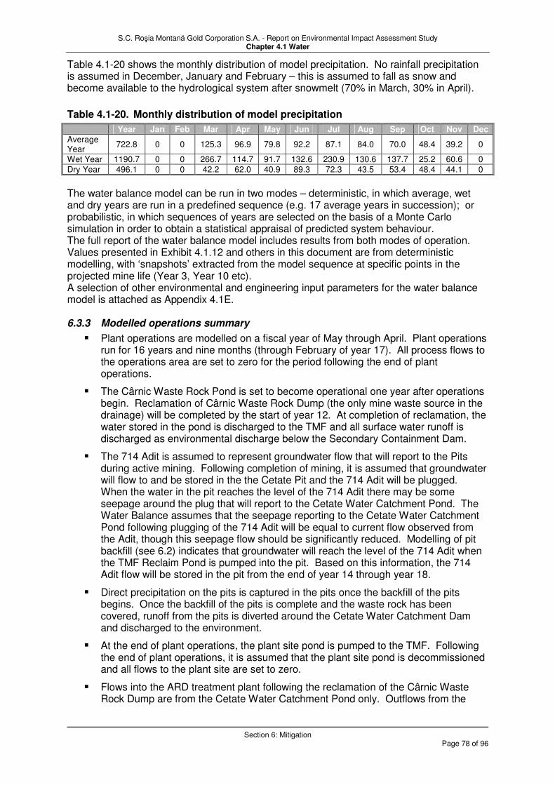
S.C. Roşia Montană Gold Corporation S.A. - Report on Environmental Impact Assessment Study Chapter 4.1 Water
Section 6: Mitigation
Page 78 of 96
Table 4.1-20 shows the monthly distribution of model precipitation. No rainfall precipitation is assumed in December, January and February – this is assumed to fall as snow and become available to the hydrological system after snowmelt (70% in March, 30% in April).
Table 4.1-20. Monthly distribution of model precipitation
Year Jan Feb Mar Apr May Jun Jul Aug Sep Oct Nov Dec Average Year
722.8 0 0 125.3 96.9 79.8 92.2 87.1 84.0 70.0 48.4 39.2 0
Wet Year 1190.7 0 0 266.7 114.7 91.7 132.6 230.9 130.6 137.7 25.2 60.6 0
Dry Year 496.1 0 0 42.2 62.0 40.9 89.3 72.3 43.5 53.4 48.4 44.1 0
The water balance model can be run in two modes – deterministic, in which average, wet and dry years are run in a predefined sequence (e.g. 17 average years in succession); or probabilistic, in which sequences of years are selected on the basis of a Monte Carlo simulation in order to obtain a statistical appraisal of predicted system behaviour. The full report of the water balance model includes results from both modes of operation. Values presented in Exhibit 4.1.12 and others in this document are from deterministic modelling, with ‘snapshots’ extracted from the model sequence at specific points in the projected mine life (Year 3, Year 10 etc). A selection of other environmental and engineering input parameters for the water balance model is attached as Appendix 4.1E. 6.3.3 Modelled operations summary
� Plant operations are modelled on a fiscal year of May through April. Plant operations run for 16 years and nine months (through February of year 17). All process flows to the operations area are set to zero for the period following the end of plant operations.
� The Cârnic Waste Rock Pond is set to become operational one year after operations begin. Reclamation of Cârnic Waste Rock Dump (the only mine waste source in the drainage) will be completed by the start of year 12. At completion of reclamation, the water stored in the pond is discharged to the TMF and all surface water runoff is discharged as environmental discharge below the Secondary Containment Dam.
� The 714 Adit is assumed to represent groundwater flow that will report to the Pits during active mining. Following completion of mining, it is assumed that groundwater will flow to and be stored in the the Cetate Pit and the 714 Adit will be plugged. When the water in the pit reaches the level of the 714 Adit there may be some seepage around the plug that will report to the Cetate Water Catchment Pond. The Water Balance assumes that the seepage reporting to the Cetate Water Catchment Pond following plugging of the 714 Adit will be equal to current flow observed from the Adit, though this seepage flow should be significantly reduced. Modelling of pit backfill (see 6.2) indicates that groundwater will reach the level of the 714 Adit when the TMF Reclaim Pond is pumped into the pit. Based on this information, the 714 Adit flow will be stored in the pit from the end of year 14 through year 18.
� Direct precipitation on the pits is captured in the pits once the backfill of the pits begins. Once the backfill of the pits is complete and the waste rock has been covered, runoff from the pits is diverted around the Cetate Water Catchment Dam and discharged to the environment.
� At the end of plant operations, the plant site pond is pumped to the TMF. Following the end of plant operations, it is assumed that the plant site pond is decommissioned and all flows to the plant site are set to zero.
� Flows into the ARD treatment plant following the reclamation of the Cârnic Waste Rock Dump are from the Cetate Water Catchment Pond only. Outflows from the

S.C. Roşia Montană Gold Corporation S.A. - Report on Environmental Impact Assessment Study Chapter 4.1 Water
Section 6: Mitigation
Page 79 of 96
ARD treatment plant go to environmental discharge only. Underflow solids will be deposited in the TMF while it exists. After that, it is deposited in Cetate pit lake.
� Evaporation from the TMF reclaim pond is calculated from the stage, volume and area data. The volume of the pond at the beginning of the month is used to calculate the area of the pond using linear interpolation. The area of the reclaim pond at a volume of 2,500,000 m3 is used to determine the area of the tailings beach.
� At the end of plant operations, flows continue to accumulate in the TMF and reclaim from the pond for plant operations ceases.
6.3.4 Water balance results Full details for the model results are contained in the Site Water Balance Report and associated spreadsheets and technical memorandum updates. The nominal (average condition) flows for 43 points on the overall water management system for the Project operation are shown on Exhibits 4.1.8, 4.1.10, 4.1.11 and 4.1.12. This includes ‘snapshot’ deterministic results for Years 3, 10 and 15 of the Project operating life, together with a ‘life of mine’ (LOM) average over the 17 years of operation. Exhibit 4.1.23 tabulates the flows for Years 3, 10, 15 and LOM as shown in Exhibit 4.1.12, and also includes results from the deterministic modelling using wet conditions and dry conditions. The precipitation definitions for these conditions are shown above in Table 4.1-20 and Figure 4.1.13. It is reiterated that the wet and dry scenarios in the model represent rainfall conditions outside of anything experienced in Roşia Montana over the past 22 years (Figure 4.1.13). Exhibit 4.1.24 summarises the water balance model flows for Areas 1-5, i.e. the main mine operation areas but excluding the fresh and potable water supply, domestic waste water and water storage groups. This exhibit differs from Exhibit 4.1.23 in that the individual water balance streams are organised into inputs, outputs and net balances for each principal mine operation. For Area 4 (ARD waste water treatment plant) the net balance is zero throughout, for the other areas the net balance represents a net change in storage within the area concerned, for example in the TMF decant pond, Cetate Water Catchment Dam or Cârnic Waste Rock Drainage Pond. These net changes are shown as absolute values (m3/hr) and also as percentages of the total inflows. For the purposes of the EIA, most of the values in the water balance are of little direct relevance, because they relate to flows which are essentially internal to the mining facility. The values which are most relevant to the EIA are those which relate to discharges from the facility to the environment – these are highlighted in blue in Exhibit 4.1.24, and comprise the environmental discharges of treated water from the Cârnic Waste Rock Drainage Pond to the Corna Valley (when the quality allows) and the compensation flows to the Roşia and Corna Valleys from the ARD Waste Water Treatment Plant.
6.4 Sediment and Erosion Control
During the construction phase, sediment loading from storm events will be controlled using international BMPs, including small catchment dams and silt fences. These procedures are described in greater detail in the Water Management and Erosion Control Plan. As a result, sediment loads from new and historically disturbed areas within the Project boundary will be controlled. A net improvement in storm event total suspended solids concentrations in Roşia and Corna Streams should occur compared to existing conditions and runoff from any newly disturbed areas will be properly controlled using BMPs. During operation and early in closure, sediments will be controlled with permanent facilities, in addition to the use of BMPs at facility-specific disturbed areas. In Roşia Valley, the Cetate Water Catchment Pond will act as the downstream sediment collection facility and mitigate this potential impact. Releases will occur from this pond only during extreme precipitation events (that is, greater than a 1 in 100-year 24-hour event). A short-term increase in sediment load may be observed in the Roşia Stream downstream of the site in this condition.
S.C. Roşia Montană Gold Corporation S.A. - Report on Environmental Impact Assessment Study Chapter 4.1 Water
Section 6: Mitigation
Page 80 of 96
However, during such a large event, the Cetate Water Catchment Dam will still capture a large quantity of the sediment. In the Corna Valley, the TMF will act as the primary sediment control basin. Uncontrolled releases from this facility will not occur unless two successive PMP events occur followed by a 1:10 year 24-hour storm event. In closure, reclamation with revegetation will substantially reduce the sediment load from the Project areas. Stable landforms will be an objective as presented in the Mine Rehabilitation and Closure Management Plan. The site sediment control features will be maintained and sediment loads monitored until the site is erosionally stable.
6.5 Waste Water Treatment
Mitigation measures to prevent chemical substances that could enter the aquatic environment from the Project exceeding concentrations stipulated in TN001 comprise treatment of wastewaters generated by the Project. Four main types of wastewater are generated; process water, acid rock drainage, domestic and impacted storm water. These wastewaters and the mitigation of their potential impact by treatment are described in sub-section 4.2. The treatment technology and infrastructure is described in detail in Chapter 2. In summary, wastewater treatment achieves the following mitigation:
� Cyanide detoxification
Cyanide is used in the extraction of gold from the ore. Detoxification reduces the cyanide content of the tailings from 180 to 190 mg/L, down to less than 10 mg/L WAD CN in accordance with the EU Mine Waste Directive on discharge to the TMF. Dilution by precipitation and runoff to the TMF will produce a further reduction to 95 to 75% of these levels, and natural degradation will result in up to a further 50% reduction. The passive wetlands below the SCD are designed to reduce cyanide levels to within TN001 (0.1 mg/l) as well as reducing the levels of nitrites, nitrates and ammonia, dissociation byproducts of cyanide, and sulphocyanate, to within TN001. Alternatively low cyanide concentrations will be treated in the secondary cyanide waste water treatment plant.
� ARD
The cyanide detox process will produce an increase in calcium, sulphate, molybdenum and arsenic (sub-section 4.3., Table 4.1-18). These substances will be reduced to within TN001 by the ARD wastewater treatment plant after pumping from the SCD. ARD generated by Project activities will also be treated by the ARD wastewater treatment to reduce metal concentrations and bring pH to within TN001 (Table 4.1-16). Calcium and sulphate, and hence TDS, will be reduced to within TN001 by the additional treatment incorporated into the ARD wastewater treatment plant specifically designed to deal with these parameters.
� Domestic wastewater
Prior to construction of the domestic wastewater treatment plant, domestic wastewater from the construction camp will be treated to within TN001 by a temporary facility. Durng this period portable facilities will be provided in outlying areas. During the operational period the domestic wastewater treatment plant will reduce all parameters to within TN001 before disposal to the TMF.
6.6 Parameter specific comments
� Calcium, sulphate and TDS
Because lime is the major reagent added in the Acid Rock Drainage treatment process to effect the removal of the metals through adjustment of pH, the calcium load would increase in Roşia Stream. This would also result in an increase in concentration in the Roşia Stream. The ARDWWTP process will also commonly reduce the sulphate load associated with most acid rock drainage influents. However, this reduction in sulphate load may be negated by the treatment of increased quantities of acid rock drainage, with a resulting increase the actual total load.

S.C. Roşia Montană Gold Corporation S.A. - Report on Environmental Impact Assessment Study Chapter 4.1 Water
Section 6: Mitigation
Page 81 of 96
The reduction in concentration is because the addition of calcium results in the precipitation of calcium sulphate. However, the solubility of calcium sulphate (gypsum) is above typical standards. Therefore, although the load may be reduced by the treatment, the concentration of sulphate may still be above the standard (even though sulphate is relatively benign compared to the relative benefits of removing the metals). Because levels of both calcium and sulphate are elevated, this results in elevated levels of total dissolved solids (TDS). The ARD Waste Water Treatment Plant will be optimised for calcium removal, and secondary treatment for SO4 included (see Chapter 2).
� Cyanide
As discussed above, cyanide concentrations are reduced to within 10 mg/L in the tailings after the detoxification treatment process. This is within the EU Extractive Waste Directive level of 10 mg/L WAD CN appropriate for tailings impoundments. For discharge, the TN001 level is 0.1 mg/l total cyanide. In order to reach this standard any water seeping through the TMF (anticipated by modelling to occur around year 10 of operation) which exceeds these standards will be returned to the decant pond from the SCD pond, or otherwise will need to be treated to within TN001 before discharge to the environment.
� pH
The only situation in which wastewater of pH lower than the TN001 standard (6.5) could be discharged to the environment is during a 24-hour storm of greater than 1 in 100 year return period in the Rosia Valley from the Cetate Dam. This is mitigated against to some extent by the provision of a limestone spillway and the dilution that would occur during the storm. However, it is still possible that pH would still be less than 6.5. In the consideration of permitting such a discharge by the Project, it should be pointed out that the pH of natural rainfall itself is often acidic. Without the project the average pH is 3.5 in the Rosia stream at sample point at S010 and is 6.3 in the River Abrud at S012.
6.7 Emergencies
The water management strategy and water treatment measures effectively mitigate against negative impacts to the water environment under normal and extreme event conditions. However, it is necessary to consider some other emergency circumstances which could conceivably impact the Project and the water environment. 6.7.1 Cyanide spillage Normally, cyanide at hazardous concentrations is handled within the controlled and isolated conditions of the Project plant area. Discharges of cyanide from the plant area to the TMF only occur following detoxification to within EU limits of 10 mg/l WAD CN, and can only occur from the TMF to the environment if total cyanide has degraded to within a concentration of 0.1 mg/l total CN (the TN001 standard). Any other accidents involving cyanide are managed in accordance with the Cyanide Management Plan. 6.7.2 TMF dam break analysis The loss of cyanide in the (extremely unlikely) circumstances of a TMF dam failure have been considered by a screening level analysis (MWH memo 1 March). This scenario is discussed in Chapter 7 (Risk).
6.8 Impacts and Mitigation Summary
The hydrological impact and mitigation aspects of the Project are summarised in the following Table 4.1-21. Residual impacts are further discussed in section 7.

S.C. Roşia Montană Gold Corporation S.A. - Report on Environmental Impact Assessment Study Chapter 4.1 Water
Section 6: Mitigation
Page 82 of 96
Table 4.1-21. Summary of Potential Water-Related Impacts
Potential Impact Mitigation Measures Applicable Management
Plans
All Project Phases (Construction, Operations and Closure)
Trash and other municipal waste littering nearby watercourses
Systematic, controlled accumulation, storage, and/or disposal of inert, municipal, and hazardous waste. Elimination of current uncontrolled waste disposal practices on the Project site.
Waste Management Plan Environmental and Social Monitoring Plan
Construction Phase
Potential releases of impacted sediments to receiving streams, especially due to storm events
International Best Management Practices during construction, including small catchment dams and silt fences. Water Management and Erosion Control Plan
Temporary discharge of domestic wastewater to Roşia Stream
Construction of temporary treatment facility for process plant site. Portable facilities in outlying areas.
Water Management and Erosion Control Plan
Operations Phase
Potential releases of impacted sediments to receiving streams, especially due to storm events
Construction of TMF and Cetate Water Catchment Dam and Pond will collect and contain sediment loading from existing and future mine-related disturbances. Use of BMPs at facility-specific disturbed areas.
Water Management and Erosion Control Plan Tailings Facility Management Plan
Impacts to hydrological and hydrogeological conditions
Supplementation of flows in Roşia and Corna Streams to maintain biological baseflow conditions, as needed. Provisions for temporary diversion of flows around the construction areas for the construction of the dams in both Corna and Roşia Valleys. Flows will be routed through the diversion works so that there is no interruption of flow during construction. During operations, unimpacted stormwater and upstream baseflows will be diverted around the Project areas and released downstream of the water management dams.
Environmental and Social Monitoring Plan
Water withdrawal from the Arieş River impact on flow and area water supply systems
Maintenance of biological baseflow in the Roşia and Corna streams, restriction on abstraction from Arieş River during extreme low flows, as needed to avoid derogation of other licensed abstractions.
Environmental and Social Monitoring Plan
Reduced groundwater recharge to surface water from pit dewatering
Augmentation of flows in Roşia Stream to maintain biological baseflow conditions, as needed. Impacts to the groundwater system outside of the immediate pit area will be mitigated by the collection and treatment of the extracted groundwater and discharged directly into Roşia Stream.
Environmental and Social Monitoring Plan
Contamination of surface water and groundwater from acidic runoff of mine waste materials
Low permeability hydraulic barriers (natural and engineered) below all storage facilities that contain potentially acid generating materials or (at the TMF) tailings containing trace quantities of cyanide. Diversion of surface water runoff around all storage areas containing potentially acid generating materials. Collection of any seepage and/or runoff from storage of any potentially acid generating materials. Treatment and discharge of all impacted water within the Roşia and Corna Valleys.
Tailings Facility Management Plan Water Management and Erosion Control Plan

S.C. Roşia Montană Gold Corporation S.A. - Report on Environmental Impact Assessment Study Chapter 4.1 Water
Section 6: Mitigation
Page 83 of 96
Potential Impact Mitigation Measures Applicable Management
Plans
Contamination of surface water and groundwater with cyanide-bearing process water (continued on next page)
Prevention of accidental releases at the process plant through pre-commissioning integrity testing of all tankage, secondary containment, pumps, and piping systems, and the establishment and regular testing of operational set points and redundant process alarms. Management of accidental release of cyanide in the process systems or from tailings pipeline through establishment of standard emergency response practices, workforce training programmes, and regular practices and drills. Engineered secondary containment bunds and systems installed for all storage tanks and transfer pumps and pipelines Provisions in the process plant design for the capture and return of any contained cyanide-bearing spill materials or fluids back to the process. Substantial reduction of cyanide levels in water discharged to the TMF through implementation of the cyanide detoxification process. Enabling of the additional reduction of low residual cyanide concentrations in the TMF from natural attenuation processes. Closed loop process design, with no discharge other than detoxified tailings and recycling of TMF decant water back to the process plant makeup water system. Low permeability hydraulic barriers (natural and engineered) below all storage facilities that containing cyanide-bearing fluids and materials.
Emergency Preparedness and Spill Contingency Plan Water Management and Erosion Control Plan Cyanide Management Plan Tailings Facility Management Plan Mine Reclamation and Closure Plan
Contamination of surface water and groundwater with cyanide containing process water (continued from previous page)
Establishment of drains and a collection system to capture TMF seepage that may contain trace levels of cyanide, and return it to the TMF decant pond and thence the process water makeup system. Minimisation of TMF seepage and enhancement of collection systems from favorable hydrogeologic conditions. Development of a contingency seepage treatment cell system, which will be tested and permitted during the operational period and may be used to treat and discharge seepage in closure. Secondary cyanide waste water treatment if required Design of the TMF with a capacity to store in excess of two PMP storm events. Installation of a secondary groundwater monitoring system below the TMF that is convertible to a tertiary recovery system.
Emergency Preparedness and Spill Contingency Plan Water Management and Erosion Control Plan Cyanide Management Plan Tailings Facility Management Plan Mine Reclamation and Closure Plan
Impacts from discharge of domestic wastewater from an increased population of site workers
Construction and use of a domestic wastewater collection and treatment system. Wastewater will not be discharged to environment, but to the process water system. Therefore, an impact is not anticipated.
Water Management and Erosion Control Plan
Closure and Post-closure Phase
Potential releases of impacted sediments to receiving streams due to storm events
Revegetation The site sediment control features will be maintained and sediment loads monitored until the site is erosionally stable.
Mine Rehabilitation and Closure Management Plan
Reduced groundwater recharge to surface water
A pit lake treatment system to address pit lake water that would discharge to the Roşia Valley. ARD waste water treatment plant will continue to operate as necessary. If flows drop below the biological baseflow in Roşia Valley, the flow will be made up from a discharge from the pit water treatment plant or pumping to the semi-passive pit water treatment system.
Mine Rehabilitation and Closure Management Plan

S.C. Roşia Montană Gold Corporation S.A. - Report on Environmental Impact Assessment Study Chapter 4.1 Water
Section 7: Residual Impacts
Page 84 of 96
7 Residual Impacts
7.1 Water Quality Analysis
7.1.1 Introduction In order to evaluate the residual impacts of the project on surface water quality, two modelling studies were undertaken. The first was an assessment of the ARD wastewater treatment plant discharge on general downstream watercourse quality, particularly metal concentrations and pH. The second examined the likely concentration of the major substances introduced by the project in the watercourses, that is, calcium, sulphate and cyanide, since treatment for these substances by the project had been introduced into the project design after the first round of modelling. 7.1.1.1 Model 1 – general surface water quality estimate The results of the first model were presented in Table 4.1-16. Reduction of ARD wastewater to within TN001 for all parameters except calcium and sulphate (and hence TDS) is apparent. 7.1.1.2 Model 2 – calcium and sulphate The lime treatment process is the most common method for treating Acid Rock Drainage from mine sites and is recognised as a Best Available Technology. However, while removing toxic metals and elevating pH, it does have the limitation of often not being able to meet calcium, sulphate and TDS standards. This is a limitation, but the net benefit of this proven and widely used treatment method results in it being the commonly accepted as a standard technology for treating effluents from mine sites with Acid Rock Drainage. In order to bring calcium and sulphate to within TN001, further treatment for these parameters was included within the project design. The second model is a check on the likely residual concentrations of calcium and sulphate that are expected in the watercourses downstream of the project discharges. The modelling results are shown in Exhibits 4.1.25 and 4.1.26. The water quality points of interest were evaluated for dry, wet and normal conditions for Years 3, 10, 15 and Closure. Closure water quality is generally assumed at the end of mining in Years 17 or 18. The Probable Maximum Precipitation (PMP) event was also to be considered. However, only limited analysis was completed for this event because there was no basis for predicting flows in the water catchments downstream of the project. Two groups of points were evaluated. One group consisted of water quality locations on streams and rivers in the area. The water quality evaluations for these points largely used mass balance calculations that considered mass loading rates from the various streams and sources. Baseline water quality data were readily available to assist in this analysis. However, only sparse flow data were available (i.e., Stations CW01, AW01, SW01, RW01 and Aries at Campeni). The more significant assumptions used for the analysis were therefore associated with flow estimations. The second group of points were more static locations such as the Tailings Management Facility (TMF) decant pond and the Cetate pit lake. These data were generally derived from previous analyses and are summarized in the analysis presentation. It is difficult to provide a representative prediction of the water quality at the 714 Adit through the life of the project, and given that this water will be routed directly through the Wastewater Treatment Plant, specific water quality estimations were not made. 7.1.1.3 Model 3 – cyanide The fate of cyanide was also modelled, Exhibit 4.1.26. Of the parameters analysed, cyanide presented the most difficult analysis. Baseline cyanide concentrations for area streams and rivers are generally not available. In addition, discharges exceeding the TN001 standard of 0.1 mg/L total cyanide are not expected. Therefore, most water quality points were reported as less than 0.1 mg/L and are not shown

S.C. Roşia Montană Gold Corporation S.A. - Report on Environmental Impact Assessment Study Chapter 4.1 Water
Section 7: Residual Impacts
Page 85 of 96
on Exhibit 4.1.26. The exceptions are the TMF decant pond and the Secondary Containment Dam (SCD) pond and sump. The overall accuracy of the analysis of the fate of calcium, sulphate and cyanide is considered limited by the available flow data, and the general difficulty in predicting chemical responses to changes in flow given the currently available data. However, the analysis should provide a general indication of the water quality as the result of residual project impact. 7.1.2 Residual Impacts Calcium does not exceed TN001 at any stage of the project. Sulphate concentrations are also within TN001 in the Rosia valley, but slightly above MO1146 Class IV, even so, they are less than the baseline condition. Due to elevated sulphate levels in the Abrud upstream of the Rosia confluence, downstream of the confluence the levels continue to be elevated under dry conditions. Although elevated levels of sulphate and cyanide occur in the TMF and in the SCD, through project mitigation, no exceedances of TN001 or MO1146 Class IV occur downstream of these structures. Thus the only residual impact by the project on surface water quality occurs in the instance of overspill of the Cetate dam during a 24 hour storm of greater than 1:100yr magnitude. During such an event the pH of the overspill waters are likely to be slightly below TN001 (pH 6.5, see sub-section 4.3.). The limestone spillway is designed as a partial mitigation against such an occurrence.
7.2 Surface Water Flows
There are two aspects of the Project that result in impacts on surface water flow rates in the Arieş system and its tributaries. These are:
� Impact on the flows in the Roşia and Corna streams as a result of interception of water from higher in the catchments by the Cetate Water Catchment Pond and TMF respectively; and
� Impact on the Arieş River due to abstractiion of fresh water for the Project.
7.2.1 Impact on the Roşia and Corna streams The baseline condition of the Roşia and Corna streams is described in sub-section 2. Table 4.1-5 summarises the flows in the streams from measurements made at the wiers installed for the baseline monitoring. These show average daily flows in the Rosia stream of 625.2 m3/hr (174 L/s), with a minimum of 41.3 m3/hr (11.5 L/s) and maximum of 7862.9 m3/hr (2184 L/s). For the Corna stream the average flows are 487.4 m3/hr (135.3 L/s), with minimum of 59.5 m3/hr (16.5 L/s) and maximum of 5909.7 m3/hr (1642 L/s). Recent observations of the 714 Adit outflow in the Roşia Valley indicate that the flow varies from approximately 39.6 to 63.0 m3/hr (11.0 – 17.5 L/s) on a monthly average basis. Based on this, the estimated average annual flow rate is 51.1 m3/hr (14.2 L/s). About 8 % of the total average Roşia Valley flow is from the 714 adit. The Corna valley also has significant mine outflow (16.2 m3/hr, 4.5 L/s) representing about 3% of the average stream flow. The drainage system is shown schematically in Exhibit 4.1.6, Surface Water Flows with average, maximum and minimum daily flows at the measuring locations. Although monitoring is not for the same period, a rough comparison of average daily flows is possible. As a percentage of the Arieş flow at Câmpeni, the stream flows are as follows; Abrud at Abrud (11.4%), Rosia (1.4%), Salistei (0.9%), Corna (1.1%) and Abruzel (1.1%). It can be seen from Exhibit 4.1.6 that the Corna contributes about 9% of the flow in the Abrud River on average, and the Roşia another 11% by its confluence with the Abrud. (sub-section 2. also describes the chemical impact these contaminated streams have on the Abrud).

S.C. Roşia Montană Gold Corporation S.A. - Report on Environmental Impact Assessment Study Chapter 4.1 Water
Section 7: Residual Impacts
Page 86 of 96
The Project intercepts contaminated water from the Roşia and Corna catchments while diverting as much clean surface water as possible for return to the streams. Nevertheless, some of the treated water from the ARD waste water treatment plant is discharged back to the streams as compensation flow. This amount averages 237.42 m3/hr (66 L/s) over the operational life of the mine (Exhibit 4.1.12, stream 35). This is less than the average baseline flows which total 309.3 m3/hr (85.9 L/s), although it does not include diverted clean water flows. The apparent reduction in flow in the two streams (71.9 m3/hr, 20 L/s) is accounted for almost exactly by the intercepted mine water flows which together total 67.3 m3/hr (18.7 L/s) – so the 23% (maximum) reduction in flow is offset by the removal of the most contaminated component. The impact on the River Abrud of the 71.9 m3/hr (20 l/s) reduction is negligible – about 1.4% of its total average flow. Moreover, the Project is committed to maintaining minimum flows in the Roşia and Corna streams of 72 m3/hr (20 L/s) and 25.2 m3/hr (7 L/s) respectively. These are the estimated biological compensation baseflows which will be conducive to ecological sustainability when the streams have recovered sufficiently in quality terms to support aquatic fauna and flora. In the case of the Roşia stream lower flows than this minimum flow have already been recorded in the baseline data between 2000 and 2005. 7.2.2 Abstraction impact on the Arieş River Fresh water totalling 238 m3/hr (66 L/s) is required for a number of Project uses. The principal demand on fresh water is as a component of the process water demand - 207 m3/hr (57.5 L/s) on average, representing 14% of the total process water intake. From the water balance flowchart presented as Exhibit 4.1.12, Water Balance Flowchart, maximum fresh water demand over the Project life is estimated as 251 m3/hr, (70 L/s). Based on the maximum requirement, a design maximum of 350 m3/hr was used for the pumping station and pipeline for the supply of freshwater from the Arieş River, via an intake located upstream of the confluence with the Abrud River. For comparison, a review of flow data for the Arieş River from 1975 to 2000 is presented in Table 4.1-12 and gives an average annual daily flow of 45,300 m3/hr (12,580 L/s), with a minimum daily flow recorded of 2,860 m3/hr (794 L/s). Currently licensed abstractions amount to 8,154 m3/hr (2265 L/s). The design maximum uptake for the Project represents less than 1% of the average flow in the Arieş River, and 12% of the minimum recorded flow. In order to confirm the availability of the water source, the plant water demand was compared to the recorded Arieş River flows during dry periods, combined with the existing licensed water abstraction at Câmpeni and Roşia Poieni. It should be noted that the actual maximum abstraction in the area of Cimpeni to Girde during 1995 to 2000 was only 1,340 m3/hr (372 L/s), equivalent to only 16% of the licensed abstraction rate. The minimum required environmental flow in the Arieş River, as defined by “Apele Române” is 100 L/s or 360 m3/hr. Evaluation (sub-section 3.2) indicates that, with the maximum actual abstraction and using the minimum daily recorded flow, the Project would have a 100% reliable water supply, while at the same time allowing for an environmental flow three times higher than the minimum required by Apele Române. If the existing users were to abstract up to their maximum licensed amount, the Arieş River would still meet all demands 96% of the time. The remaining 4% of the time represents periods of extreme low flow. Given that actual abstraction is only 16% of the licensed abstraction, it appears unlikely that sufficient flow would be not be available. However, if all licensed users utilised their full allotment, there may be a few days when withdrawals from the Arieş River may have to be reduced, with water supply to the Project being made up from storage and temporary reallocations in the water balance.

S.C. Roşia Montană Gold Corporation S.A. - Report on Environmental Impact Assessment Study Chapter 4.1 Water
Section 7: Residual Impacts
Page 87 of 96
7.3 Positive Impacts
7.3.1 Surface Water Quality The current status of water quality in Roşia Valley, Corna Valley and the Abrud River are presented in the State of the Aquatic Environment Report in Baseline Reports, Report 1. Exhibit 4.1.9 provides a summary of the levels of some key indicators of environmental surface water pollution. More detail is provided in Exhibits 4.1.10 and 4.1.11. The degradation of surface water quality is primarily a result of surface water runoff from uncontrolled disposal of waste materials from the current and historic mining operations. Another aspect associated with the uncontrolled surface water runoff is the transport and deposition of contaminated sediments in the downstream watercourse. The Project is designed to remove or control these sources, and without the Project, such uncontrolled releases to surface water will continue. 7.3.1.1 Collection and treatment of existing acidic runoff from uncontrolled historical
workings and waste rock stockpiles: As part of Project development, surface water diversions will be constructed around all waste rock stockpiles, and collection and containment systems will be constructed for impacted runoff water. Wastewater treatment systems will be constructed to treat all impacted waters before release to the environment. Discharge from the 714 Adit in the Roşia Valley has been identified as one of the primary sources for toxic metals loading to Roşia Valley and the Abrud River. This is supported by data presented in the State of the Aquatic Environment Report. The Project will be designed to collect, contain and treat this specific flow; without the Project, the uncontrolled and untreated release of 714 Adit water will continue. The water quality improvements obtained in Roşia and Corna Valleys will be translated to a net reduction in chemical loadings and improvements in downstream water quality in the Abrud and Arieş Rivers. The most notable positive impact of the Project will be in the reduction of toxic metals. The scale of this positive impact is summarised in Table 4.1-16. The improvement to surface water quality caused by the main Project discharge to the Rosia and Corna valleys is apparent, with a reduction in the level of all measured parameters, particularly metals and pH. 7.3.1.2 Long-term water quality improvements due to the elimination or closure of
mine wastes and acid rock drainage sources in the Project area: The water quality improvements realised will extend beyond the life of the Project. The Project has committed to closing the site such that water pollution sources are reduced or eliminated, and any residual polluted flows treated. In contrast to current conditions, which are significantly degraded, in closure, water discharging from the site will meet and continue to meet TN001. Current pre-Project sources such as waste rock and mine adit flows are included by default in this closure program. During the course of mining most of the current waste rock piles and mine workings that contribute to impacted discharges will be removed. The water quality improvement associated with these actions will be permanent. The remaining potential sources will largely be associated with the Project. These sources will be closed using source controls to reduce environmental discharges with any residual flow treated to meet water quality standards. Closure will be implemented in such a way that treatment requirements will decrease in the years following the project. The closure process is described in detail in the Mine Rehabilitation and Closure Plan (ESMS Plans, Plan J). 7.3.2 Sediments and Suspended Solids Under baseline conditions, sediment loading is uncontrolled from the current mining features and associated roads and baseline conditions are degraded. During the construction phase, sediment loading from storm events will be controlled using international BMPs, including small catchment dams and silt fences. These procedures are described in greater detail in the Water Management and Erosion Control Plan (ESMS Plans, Plan C). As a result, sediment loads from new and historically disturbed areas within the Project boundary will be controlled. A net improvement in storm event total suspended solids concentrations in Roşia

S.C. Roşia Montană Gold Corporation S.A. - Report on Environmental Impact Assessment Study Chapter 4.1 Water
Section 7: Residual Impacts
Page 88 of 96
and Corna Streams should occur compared to existing conditions and runoff from any newly disturbed areas will be properly controlled using BMPs.

S.C. Roşia Montană Gold Corporation S.A. - Report on Environmental Impact Assessment Study Chapter 4.1 Water
Section 8: Monitoring
Page 89 of 96
8 Monitoring
8.1 Introduction
The management and mitigation of surface water and groundwater quality impacts, from historical sources as well as anticipated Project operations is among the most predominant environmental issues that must be addressed over the life of the Project. Towards that end, RMGC commissioned several studies of background conditions (see the “State of the Aquatic Environment Report and the other companion reports in the Roşia Montană Project Baseline Reports). RMGC also established a robust surface water and groundwater monitoring programme in the feasibility stage of the Project in order to further characterise the nature and extent of the historical contamination upstream and downstream from potential sources of contamination on the Project site, as well as background conditions in adjacent watersheds that will not be directly impacted by Project operations. The RMGC Environmental Database was originally developed to support surface and groundwater monitoring activities in the pre-construction phase, but, as discussed in Chapter 6, Monitoring, Section 6.1.1, the database will be adapted and expanded to serve the full set of environmental and social monitoring needs set out in the Environmental and Social Monitoring Plan (ESMS Plans, Plan P). This section identifies the water-related parameters which will be monitored during the life of the mine in order to:
� Extend the baseline record and identify any trends in the background environment;
� Monitor the environmental performance of the Project;
� Verify the mitigation measures implemented to minimise negative impacts; and
� Provide the basis for continuing review and improvement of environmental management systems.
The surface water and groundwater monitoring locations currently established for the preconstruction/construction phase of the Project are as shown in the map provided as Exhibit 6.1. These locations include permanently installed weirs, monitoring wells, and water supply wells, as well as sampling points in various springs and streams. Sampling locations were selected in order to properly characterise the existing water quality associated with historical mining sites in the Roşia Montană, Corna, and Abruzel valley drainages, as well as other specific locations in or near the Aries and Abrud River watercourses. Management aspects of water-related monitoring are specified in Section 5.3 of the Water Management and Erosion Control Plan. These include quality control, regulatory compliance and reporting procedures.
8.2 Water Quality Monitoring
8.2.1 Parameters and methods The monitoring parameters and analytical methods currently established for the chemical and physical analysis of surface and groundwater monitoring programme samples are presented in Table 4.1-22.

S.C. Roşia Montană Gold Corporation S.A. - Report on Environmental Impact Assessment Study Chapter 4.1 Water
Section 8: Monitoring
Page 90 of 96
Table 4.1-22. Analytical parameters/methods for physical and chemical analysis
No. Analytical Parameter Analytical Method MDLs
Field Parameters
1 Redox potential Information acquired via CONSORT P601 per manufacturer’s instructions
N/A
2 Conductivity Information acquired via HACH SENSION 156 per manufacturer’s instructions
N/A
3 pH Information acquired via HACH SENSION 156 per manufacturer’s instructions
N/A
4 Turbidity Information acquired via SPEKOL spectrophotometer per manufacturer’s instructions
0.1 NTU
5 Temperature Information acquired via HACH SENSION 156 per manufacturer’s instructions
N/A
Laboratory Parameters
6 Suspended particles STAS 6953/81 0.5 mg/l
7 Sodium STAS 3223 – 1/91 5 µg/l 8 Potassium STAS 3223 – 2/91 15 µg/l
9 Calcium STAS 3662/90 3 µg/l 10 Barium APHA Standard Methods (1992), method 3113.B 1 µg/l
11 Magnesium SR ISO 7980/86 10 µg/l 12 Antimony APHA Standard Methods (1992), method 3114.B 0.05 µg/l 13 Arsenic (total) APHA Standard Methods (1992), method 3114.B 0.05 µg/l
14 Arsenic (dissolved) APHA Standard Methods (1992), method 3114.B 0.05 µg/l 15 Chloride STAS 3049/88 0.40 µg/l
16 Sulphate STAS 3069/87 0.40 µg/l 17 Iron (total) SR 13315/96 25 µg/l 18 Iron (as Fe
2+) SR ISO6332/96 10 µg/l
19 Manganese APHA Standard Methods (1992), method 3113.B 1 µg/l 20 Lead (total) APHA Standard Methods (1992), method 3113.B 1 µg/l
21 Lead (dissolved) APHA Standard Methods (1992), method 3113.B 1 µg/l 22 Copper Total) APHA Standard Methods (1992), method 3113.B 1 µg/l
23 Copper (dissolved) APHA Standard Methods (1992), method 3113.B 1 µg/l
24 Cadmium (total) APHA Standard Methods (1992), method 3113.B 1 µg/l
25 Cadmium (dissolved) APHA Standard Methods (1992), method 3113.B 1 µg/l
26 Zinc (total) APHA Standard Methods (1992), method 3113.B 1 µg/l
27 Zinc (dissolved) APHA Standard Methods (1992), method 3113.B 1 µg/l 28 Nickel (total) APHA Standard Methods (1992), method 3113.B 1 µg/l
29 Nickel (dissolved) APHA Standard Methods (1992), method 3113.B 1 µg/l 30 HCO3/CO3 SR ISO 9963 – 1 N/A
31 Nitrate STAS 3048 – 1/77 20 µg/l
32 Fluoride STAS 3048 – 2/77 50 µg/l
33 Selenium APHA Standard Methods (1992), method 3114.B 0.05 µg/l 34 Cobalt APHA Standard Methods (1992), method 3113.B 1 µg/l
35 Cyanide (total) STAS 10847/77 2.5 µg/l
36 Mercury STAS 8045-79 0.1 µg/l 37 Molybdenum APHA Standard Methods (1992), method 3113.B 1 µg/l
38 Chromium (total) SR ISO 9174 1 µg/l 39 Chromium (hexavalent) STAS 7884/91 10 µg/l 40 Phenols STAS R 7167/92 10 µg/l
41 Phosphate SR ISO 10304/99 10 µg/l
42 Biological Oxygen Demand STAS 6560/82 N/A
43 Chemical Oxygen Demand SR ISO 6060/96 N/A 44 Silicon Oxide STAS 9375/75 N/A 45 Residue (dissolved salts) at
105°C
STAS 6953/81 0.5 µg/l
These parameters and methods will be periodically evaluated, and adjusted or updated as appropriate, in conjunction with periodic evaluations and updates of the Environmental and Social Monitoring Plan. Analytical data are entered into the RMGC Environmental Database in a manner that permits identification and resolution of any transcriptions or other data reporting errors, as well as analyses of trends at any given sampling point or sets of sampling points.
S.C. Roşia Montană Gold Corporation S.A. - Report on Environmental Impact Assessment Study Chapter 4.1 Water
Section 8: Monitoring
Page 91 of 96
In the case of mitigation and impact monitoring, exceedance of pre-set levels at crucial monitoring points will trigger a series of responses to identify the causes, nature and reaction required. These levels will be defined in the appropriate monitoring plans and will be subject to periodic review as required. 8.2.2 Monitoring programme rationale The monitoring network comprises a combination of:
� Continued monitoring at locations of environmental significance to the project; and
� Monitoring at new locations related to the Project processes.
Water quality monitoring is required for various parameters depending on the water source. Parameter suites will be defined in the appropriate monitoring plans, and a provisional schedule is shown in Table 4.1-23.

S.C. Roşia Montană Gold Corporation S.A. - Report on Environmental Impact Assessment Study Chapter 4.1 Water
Section 8: Monitoring
Page 92 of 96
Table 4.1-23. Parameter suites for water quality monitoring
Parameter Baseline Process ARD Domestic in Domestic
out
Bacteria* x x x Temperature x
pH x x x
Electrical Conductivity x x x x
Total Dissolved Solids x x Eh (Redox) x
Dissolved Oxygen x Biochemical Oxygen Demand x x Chemical Oxygen Demand x x
Turbidity x x x Suspended Solids x x x
Alkalinity x
Ca x x x Mg x x x
Na x x K x
F x x Cl x x Cl2 (chlorine) x
SO4 x x x x
HCO3 x
CO3 x NO3 x x NO2 x
NH4 - N x x x PO4 x x
Ag (dissolved) x Al (dissolved) x x x x
As (dissolved) x x x Cd (dissolved) x x x x
Cu (dissolved) x x x x
Fe (total) x x x x
Fe (dissolved) x x x x
Ni (total) x x x x
Ni (dissolved) x x x Pb (dissolved) x x x x
Zn (total) x x x Zn (dissolved) x x x x
Sb x B x Cr (total) x x x
Cr (hexavalent) x x Mn (total) x x x x
Mn (dissolved) x x x x Co x x Hg x x x x
Mo x x x Se x x
Phenols x x Detergents x x
Pesticides x x Polycyclic Aromatic Hydrocarbons (PAHs) x x CN (Total) x x x
CN (Free) x x CN (Weak Acid Dissoluble - WAD) x x
*Escherichia coli, Enterococi(Streptococi fecali), Pseudomonas aeruginosa
S.C. Roşia Montană Gold Corporation S.A. - Report on Environmental Impact Assessment Study Chapter 4.1 Water
Section 8: Monitoring
Page 93 of 96
For monitoring of the quality of Project generated waters, parameter suites appropriate to the sources are recommended. Sampling locations and suites are as follows (and in Table 4.1-24): 1) Treated Process Water – weekly monitoring of the process suite at:
� The discharge point to the TMF
� The decant pond
� The secondary containment pond
� The inflow to the passive treatment cells
� The outflow from the passive treatment cells
2) Treated Acid Rock Drainage - weekly monitoring of the ARD suite at:
� The point of discharge to Rosia Valley
� The point of discharge to Corna Valley
� The Cetate water catchment pond
� The Cetate mine pit
3) Domestic Water Supply – weekly monitoring of the ‘domestic in’ suite at:
� The treated domestic use water inlet
4) Domestic Wastewater Final Treated Effluent – monthly monitoring of the ‘domestic out’ suite at:
� The final treated domestic wastewater outlet
8.2.3 Groundwater monitoring A line of three to five boreholes will be installed downstream of the SCD to confirm by monitoring that the TMF water is being contained by the seepage collection system. If TMF hydrochemcial parameters are ever detected in the monitoring wells above regulatory standards, groundwater recovery will become a component of the seepage collection system and seepage water from the recovery wells will be pumped back to the TMF reclaim pond for recycling in the process. Water from the boreholes should be sampled and analysed for the ‘process suite’ and groundwater levels taken on a monthly basis. Monitoring locations, parameter suites and monitoring frequency for the different project phases are summarised in Table 4.1-24.

S.C. Roşia Montană Gold Corporation S.A. - Report on Environmental Impact Assessment Study Chapter 4.1 Water
Section 8: Monitoring
Page 94 of 96
Table 4.1-24. Summary of monitoring locations, parameter suites and monitoring frequency
Location Suite Project Phase Frequency Surface Water Flow Monitoring Points
Aries – Campeni All 1 Abrud - Abrud All 1 AW01 All Hourly
R085 All Daily
RW01 All Hourly
CW01 All Hourly Water Balance Node Positions Whilst
operational Daily Total Flows
Surface Water Quality Monitoring Points
S003 Baseline All Monthly
S004 Baseline All Monthly S008 Baseline All Monthly S009 Baseline All Monthly
S012 Baseline All Monthly
S013 Baseline All Monthly
S014 Baseline All Monthly R085 Baseline All 2 Monthly Groundwater Monitoring Points
Monitoring Boreholes Downstream of SCD Process and Levels
3 Monthly
Process Water Monitoring Points
Discharge Point to TMF Process Whilst operational
Weekly
Decant Pond Process Construction to Closure
Weekly
SCD Pond Process Construction to Post-Closure
Weekly
Treatment Cells Inflow Process Testing to Post-Closure
Weekly
Treatment Cells Outflow Process Testing to Post-Closure
Weekly
Treated Acid Rock Drainage Monitoring Points
Point of Discharge to Rosia Valley ARD Whilst operational
Weekly
Point of Discharge to Corna Valley ARD Whilst operational
Weekly
Cetate Water Catchment Pond ARD All Weekly Cetate Mine Pit ARD Late operational
to Post-Closure Weekly
Domestic Water Monitoring Points
Treated Domestic Water Inflow Point Domestic in Whilst operational
Weekly
Final Treated Effluent Monitoring Point Domestic out Whilst operational
Monthly
1 Frequency as per government recordings 2 Until flooded by Cetate Pond 3 After detection of TMF substances in SCD
For water quality monitoring in conjunction with surface water flows (see below), the baseline suite is recommended for monthly sampling and analysis. Sampling locations are at:
� The Aries intake to determine the intake quality and to monitor the Aries upstream of the Abrud (S013)
� The Aries downstream of the Abrud confluence (S014). This sampling point could be moved closer to the Abrud confluence to give a better indication of the impact of the Abrud on the Aries and to be related more closely to the flow measurements at Campeni.

S.C. Roşia Montană Gold Corporation S.A. - Report on Environmental Impact Assessment Study Chapter 4.1 Water
Section 8: Monitoring
Page 95 of 96
� The Rosia quality upstream (R085) and downstream (S009) of the discharge point. R085 can only be monitored until the Cetate Pond reaches the 714 adit.
� The Corna quality downstream of the discharge point (S004)
� The Abrud quality upstream of the Corna stream (S003) and the quality between Corna and Rosia streams (S008) and between Rosia stream and the River Aries (S012)
8.3 Meteorology and Surface Water Flows Monitoring
Surface water volumes and meteorological conditions are monitored, respectively, via the processes described in the RMGC Stream Flow Measurement Process Operation Manual and Project Meteorological Station Operation Manual, as noted in Section 5.1 of the Roşia Montană Project Environmental and Social Management Plan (ESMS Plans, Plan A). Results are maintained in the RMGC Environmental Database. Surface water monitoring points are the main existing locations for which continued monitoring is required. In particular monitoring is required for flows and water quality. Flow monitoring is required as shown in Table 4.1-25.
Table 4.1-25. Surface water flow monitoring locations
Item Monitoring Comment Aries Continued access to daily
government monitoring data from Campeni
To assess impact of abstraction
Abrud Continued access to daily government monitoring data from Abrud
Abrud – upper catchment AW01 – hourly
Rosia – upstream of project R085 – daily Rosia – downstream of project RW01 – hourly
Corna – downstream of project CW01 – hourly
Water Balance Node Positions Daily total flows Check process / water balance
To account for climate change (see sub-section Meteorology and Appendix 4.1B) and improvements in knowledge and predictive ability as data availability and modelling techniques improve, the project Water Management Plan will include a provision for continual review of climate change knowledge status so that any design or management implications can be identified as soon as possible and acted upon in a timely manner.

S.C. Roşia Montană Gold Corporation S.A. - Report on Environmental Impact Assessment Study Chapter 4.1 Water
Section 9: Appendices
Page 96 of 96
Appendices