CHAPTER 21.06: DIMENSIONAL STANDARDS AND MEASUREMENTS 21 12313... · Chapter 21.06: Dimensional...
32
Title 21: Land Use Planning December 3, 2013 Anchorage, Alaska Page 6-1 CHAPTER 21.06: DIMENSIONAL STANDARDS AND MEASUREMENTS 21.06.010 PURPOSE........................................................................................................................ 6-2 A. Purpose ............................................................................................................................ 6-2 B. Applicability ...................................................................................................................... 6-2 21.06.020 DIMENSIONAL STANDARDS TABLES .......................................................................... 6-2 A. Table of Dimensional Standards: Residential Districts .................................................... 6-3 B. Table of Dimensional Standards: Commercial and Industrial Districts ............................ 6-8 C. Table of Dimensional Standards: Other Districts ........................................................... 6-11 21.06.030 MEASUREMENTS AND EXCEPTIONS ........................................................................ 6-12 A. Lot Area, Width, and Depth ............................................................................................ 6-12 B. Lot Coverage.................................................................................................................. 6-12 C. Setbacks ........................................................................................................................ 6-12 D. Height .......................................................................................................................... 6-20 E. Floor Area Ratio (FAR) .................................................................................................. 6-25
Transcript of CHAPTER 21.06: DIMENSIONAL STANDARDS AND MEASUREMENTS 21 12313... · Chapter 21.06: Dimensional...
Title 21: Land Use Planning December 3, 2013 Anchorage, Alaska Page 6-1
CHAPTER 21.06: DIMENSIONAL STANDARDS AND MEASUREMENTS
21.06.010 PURPOSE ........................................................................................................................ 6-2 A. Purpose ............................................................................................................................ 6-2 B. Applicability ...................................................................................................................... 6-2
21.06.020 DIMENSIONAL STANDARDS TABLES .......................................................................... 6-2
A. Table of Dimensional Standards: Residential Districts .................................................... 6-3 B. Table of Dimensional Standards: Commercial and Industrial Districts ............................ 6-8 C. Table of Dimensional Standards: Other Districts ........................................................... 6-11
21.06.030 MEASUREMENTS AND EXCEPTIONS ........................................................................ 6-12
A. Lot Area, Width, and Depth ............................................................................................ 6-12 B. Lot Coverage .................................................................................................................. 6-12 C. Setbacks ........................................................................................................................ 6-12 D. Height .......................................................................................................................... 6-20 E. Floor Area Ratio (FAR) .................................................................................................. 6-25
Title 21: Land Use Planning Provisionally Adopted with Staff Edits – 12/12/11 Anchorage, Alaska Page 2
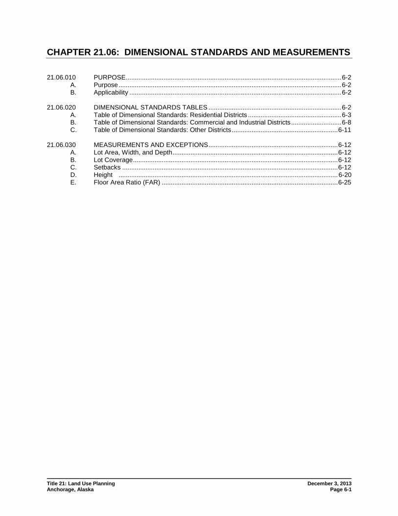
CHAPTER 21.06: DIMENSIONAL STANDARDS AND MEASUREMENTS 21.06.010 PURPOSE
A. Purpose
Specific purposes of this chapter include:
1. Preserving light and air, and avoiding congestion in residential zoning districts;
2. Promoting fire protection through appropriate separation of structures;
3. Ensuring setbacks which promote a reasonable relationship between residences and a consistent residential streetscape;
4. Promoting streetscapes that are consistent with the intended character of different commercial and mixed-use zones;
5. Promoting buildings close to the sidewalk in mixed-use districts, to reinforce a pedestrian oriented streetscape;
6. Controlling the overall building bulk and lot coverage to help define the character of different zones;
7. Promoting a reasonable building scale that is consistent with the function of local commercial areas and the character of surrounding neighborhoods; and
8. Promoting the efficient use of service capacity in areas with the highest levels of public services and intended development.
B. Applicability
This chapter applies to all development within the municipality.
(AO 2012-124(S), 2-26-13)
21.06.020 DIMENSIONAL STANDARDS TABLES
A. This section contains tables that list the requirements for lot dimensions, building bulk, density, location, and height for all types of development. All primary and accessory structures are subject to the dimensional standards set forth in the following tables. Superscript numbers refer to notes at the bottom of each table. General rules for measurement and exceptions are set forth in section 21.06.030. Dimensional standards for Girdwood and Chugiak-Eagle River zoning districts are set forth in chapters 21.09 and 21.10, respectively. General rules for measurements and exceptions apply in those areas, even if not specifically referenced, unless specifically exempted by those chapters.
B. These general standards may be further limited or modified by other applicable sections of this title. In particular, some uses have use-specific standards in chapter 21.05 that impose stricter requirements than set forth in these tables.
Chapter 21.06: Dimensional Standards and Measurements Sec.21.06.020 Dimensional Standards Tables
Title 21: Land Use Planning December 3, 2013 Anchorage, Alaska Page 6-3
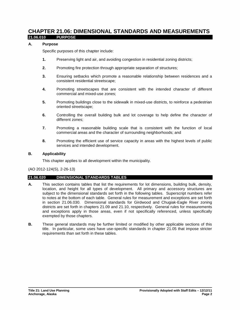
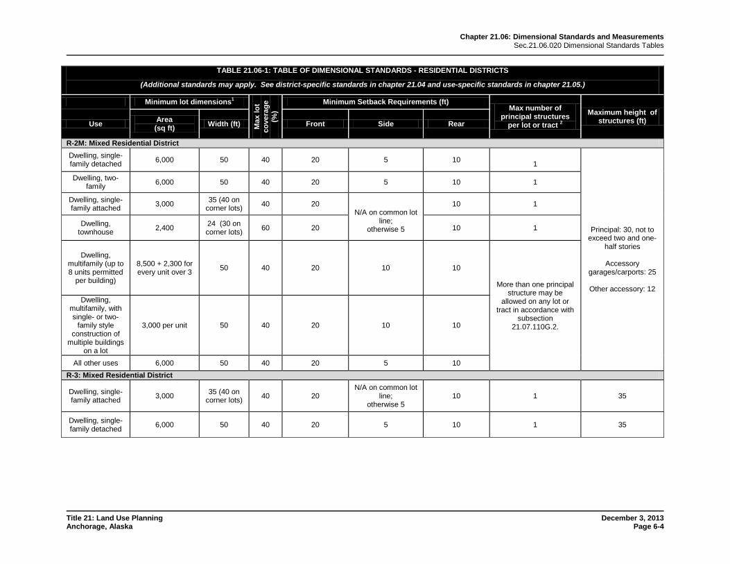
A. Table of Dimensional Standards: Residential Districts TABLE 21.06-1: TABLE OF DIMENSIONAL STANDARDS - RESIDENTIAL DISTRICTS
(Additional standards may apply. See district-specific standards in chapter 21.04 and use-specific standards in chapter 21.05.)
Minimum lot dimensions1
Max
lot
cove
rage
(%
)
Minimum Setback Requirements (ft) Max number of
principal structures per lot or tract 2
Maximum height of structures (ft) Use Area
(sq ft) Width (ft) Front Side Rear
R-1: Single-Family Residential District
Residential uses 6,000 50 303 20 5 10 1 Principal: 30 Accessory
garages/carports: 20 Other accessory: 12
All other uses 6,000 50 30 20 5 10 N/A
R-1A: Single-Family Residential District (larger lot)
Residential uses 8,400 70 303 20 5 10 1 Principal: 30
Accessory garages/carports: 20
Other accessory: 12
All other uses 8,400 70 30 20 5 10 N/A
R-2A: Two-Family Residential District (larger lot) Dwelling, single-family detached 7,200 60 40 20 5 10 1
Principal: 30, not to exceed two and one-
half stories
Accessory garages/carports: 25
Other accessory: 12
Dwelling, two-family 8,400 70 40 20 5 10 1
Dwelling, single-family attached 3,500 35 (40 on
corner lots) 40 20 N/A on common lot
line; otherwise 5
10 1
All other uses 7,200 60 40 20 5 10 N/A
R-2D: Two-Family Residential District
Dwelling, single-family detached 6,000 50 40 20 5 10 1 Principal: 30, not to
exceed two and one-half stories
Accessory
garages/carports: 25
Other accessory: 12
Dwelling, two-family 6,000 50 40 20 5 10 1
Dwelling, single-family attached 3,500 35 (40 on
corner lots) 40 20 N/A on common lot
line; otherwise 5
10 1
All other uses 6,000 50 40 20 5 10 N/A
Chapter 21.06: Dimensional Standards and Measurements Sec.21.06.020 Dimensional Standards Tables
Title 21: Land Use Planning December 3, 2013 Anchorage, Alaska Page 6-4
TABLE 21.06-1: TABLE OF DIMENSIONAL STANDARDS - RESIDENTIAL DISTRICTS
(Additional standards may apply. See district-specific standards in chapter 21.04 and use-specific standards in chapter 21.05.)
Minimum lot dimensions1
Max
lot
cove
rage
(%
)
Minimum Setback Requirements (ft) Max number of
principal structures per lot or tract 2
Maximum height of structures (ft) Use Area
(sq ft) Width (ft) Front Side Rear
R-2M: Mixed Residential District Dwelling, single-family detached 6,000 50 40 20 5 10
1
Principal: 30, not to exceed two and one-
half stories
Accessory garages/carports: 25
Other accessory: 12
Dwelling, two-family 6,000 50 40 20 5 10 1
Dwelling, single-family attached 3,000 35 (40 on
corner lots) 40 20 N/A on common lot
line; otherwise 5
10 1
Dwelling, townhouse 2,400 24 (30 on
corner lots) 60 20 10 1
Dwelling, multifamily (up to 8 units permitted
per building)
8,500 + 2,300 for every unit over 3 50 40 20 10 10
More than one principal structure may be
allowed on any lot or tract in accordance with
subsection 21.07.110G.2.
Dwelling, multifamily, with single- or two-
family style construction of
multiple buildings on a lot
3,000 per unit 50 40 20 10 10
All other uses 6,000 50 40 20 5 10 R-3: Mixed Residential District
Dwelling, single-family attached 3,000 35 (40 on
corner lots) 40 20 N/A on common lot
line; otherwise 5
10 1 35
Dwelling, single-family detached 6,000 50 40 20 5 10 1 35
Chapter 21.06: Dimensional Standards and Measurements Sec.21.06.020 Dimensional Standards Tables
Title 21: Land Use Planning December 3, 2013 Anchorage, Alaska Page 6-5
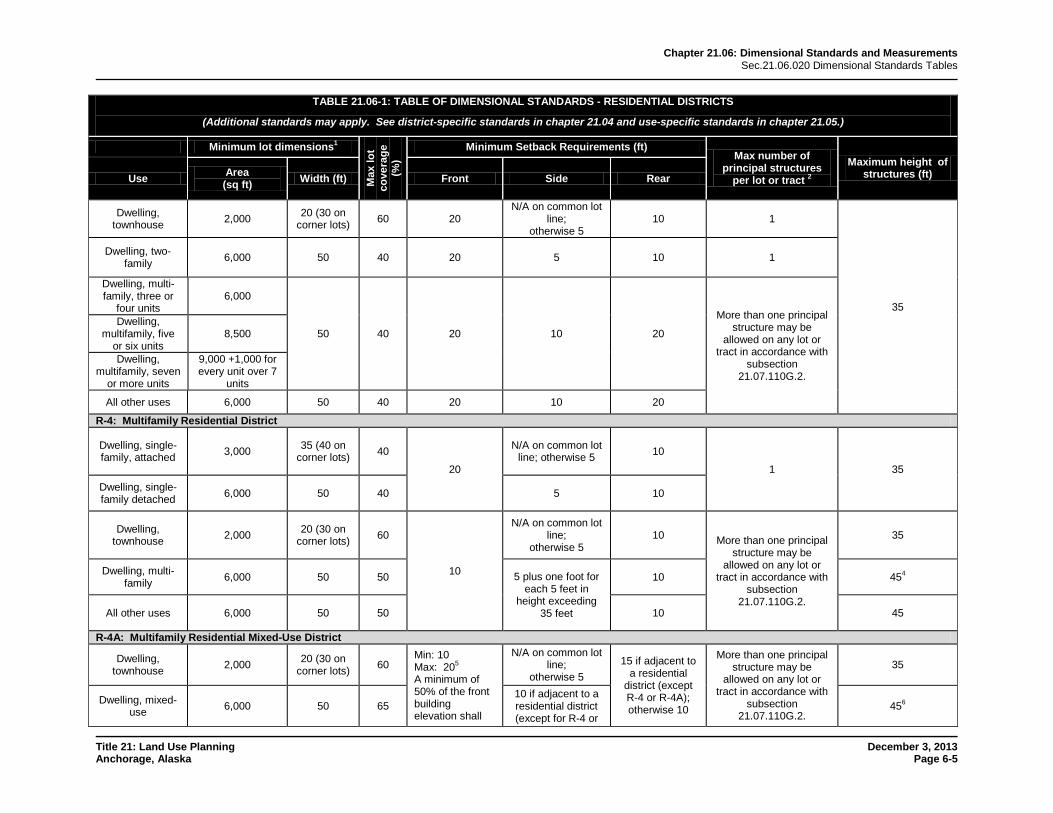
TABLE 21.06-1: TABLE OF DIMENSIONAL STANDARDS - RESIDENTIAL DISTRICTS
(Additional standards may apply. See district-specific standards in chapter 21.04 and use-specific standards in chapter 21.05.)
Minimum lot dimensions1
Max
lot
cove
rage
(%
)
Minimum Setback Requirements (ft) Max number of
principal structures per lot or tract 2
Maximum height of structures (ft) Use Area
(sq ft) Width (ft) Front Side Rear
Dwelling, townhouse 2,000 20 (30 on
corner lots) 60 20 N/A on common lot
line; otherwise 5
10 1
35
Dwelling, two-family 6,000 50 40 20 5 10 1
Dwelling, multi-family, three or
four units 6,000
50 40 20 10 20
More than one principal structure may be
allowed on any lot or tract in accordance with
subsection 21.07.110G.2.
Dwelling, multifamily, five
or six units 8,500
Dwelling, multifamily, seven
or more units
9,000 +1,000 for every unit over 7
units
All other uses 6,000 50 40 20 10 20
R-4: Multifamily Residential District
Dwelling, single-family, attached 3,000 35 (40 on
corner lots) 40
20
N/A on common lot line; otherwise 5 10
1 35 Dwelling, single-family detached 6,000 50 40 5 10
Dwelling, townhouse 2,000 20 (30 on
corner lots) 60
10
N/A on common lot line;
otherwise 5 10 More than one principal
structure may be allowed on any lot or
tract in accordance with subsection
21.07.110G.2.
35
Dwelling, multi-family 6,000 50 50 5 plus one foot for
each 5 feet in height exceeding
35 feet
10 454
All other uses 6,000 50 50 10 45
R-4A: Multifamily Residential Mixed-Use District
Dwelling, townhouse 2,000 20 (30 on
corner lots) 60 Min: 10 Max: 205 A minimum of 50% of the front building elevation shall
N/A on common lot line;
otherwise 5 15 if adjacent to
a residential district (except R-4 or R-4A); otherwise 10
More than one principal structure may be
allowed on any lot or tract in accordance with
subsection 21.07.110G.2.
35
Dwelling, mixed-use 6,000 50 65
10 if adjacent to a residential district (except for R-4 or
456
Chapter 21.06: Dimensional Standards and Measurements Sec.21.06.020 Dimensional Standards Tables
Title 21: Land Use Planning December 3, 2013 Anchorage, Alaska Page 6-6
TABLE 21.06-1: TABLE OF DIMENSIONAL STANDARDS - RESIDENTIAL DISTRICTS
(Additional standards may apply. See district-specific standards in chapter 21.04 and use-specific standards in chapter 21.05.)
Minimum lot dimensions1
Max
lot
cove
rage
(%
)
Minimum Setback Requirements (ft) Max number of
principal structures per lot or tract 2
Maximum height of structures (ft) Use Area
(sq ft) Width (ft) Front Side Rear
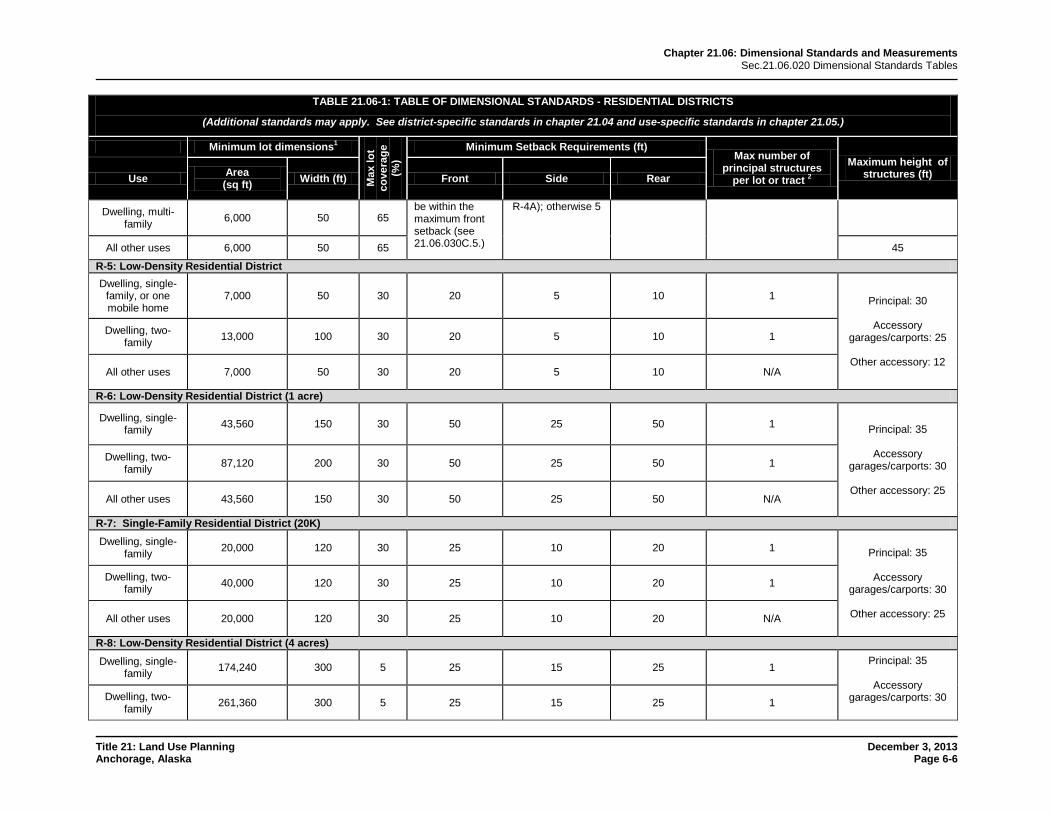
Dwelling, multi-family 6,000 50 65
be within the maximum front setback (see 21.06.030C.5.)
R-4A); otherwise 5
All other uses 6,000 50 65 45
R-5: Low-Density Residential District Dwelling, single-
family, or one mobile home
7,000 50 30 20 5 10 1 Principal: 30
Accessory garages/carports: 25
Other accessory: 12
Dwelling, two-family 13,000 100 30 20 5 10 1
All other uses 7,000 50 30 20 5 10 N/A
R-6: Low-Density Residential District (1 acre)
Dwelling, single-family 43,560 150 30 50 25 50 1 Principal: 35
Accessory
garages/carports: 30
Other accessory: 25
Dwelling, two-family 87,120 200 30 50 25 50 1
All other uses 43,560 150 30 50 25 50 N/A
R-7: Single-Family Residential District (20K) Dwelling, single-
family 20,000 120 30 25 10 20 1 Principal: 35
Accessory garages/carports: 30
Other accessory: 25
Dwelling, two-family 40,000 120 30 25 10 20 1
All other uses 20,000 120 30 25 10 20 N/A
R-8: Low-Density Residential District (4 acres) Dwelling, single-
family 174,240 300 5 25 15 25 1 Principal: 35
Accessory garages/carports: 30
Dwelling, two-
family 261,360 300 5 25 15 25 1
Chapter 21.06: Dimensional Standards and Measurements Sec.21.06.020 Dimensional Standards Tables
Title 21: Land Use Planning December 3, 2013 Anchorage, Alaska Page 6-7
TABLE 21.06-1: TABLE OF DIMENSIONAL STANDARDS - RESIDENTIAL DISTRICTS
(Additional standards may apply. See district-specific standards in chapter 21.04 and use-specific standards in chapter 21.05.)
Minimum lot dimensions1
Max
lot
cove
rage
(%
)
Minimum Setback Requirements (ft) Max number of
principal structures per lot or tract 2
Maximum height of structures (ft) Use Area
(sq ft) Width (ft) Front Side Rear
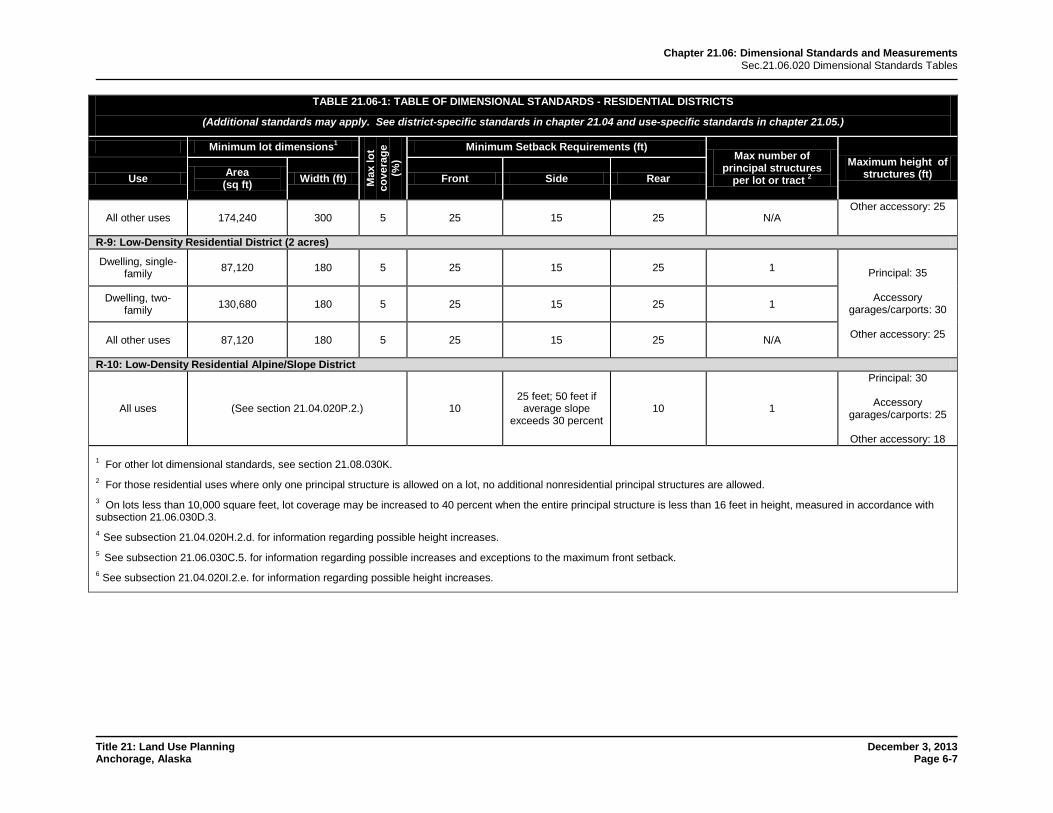
All other uses 174,240 300 5 25 15 25 N/A Other accessory: 25
R-9: Low-Density Residential District (2 acres)
Dwelling, single-family 87,120 180 5 25 15 25 1 Principal: 35
Accessory
garages/carports: 30
Other accessory: 25
Dwelling, two-family 130,680 180 5 25 15 25 1
All other uses 87,120 180 5 25 15 25 N/A
R-10: Low-Density Residential Alpine/Slope District
All uses (See section 21.04.020P.2.) 10 25 feet; 50 feet if
average slope exceeds 30 percent
10 1
Principal: 30
Accessory garages/carports: 25
Other accessory: 18
1 For other lot dimensional standards, see section 21.08.030K. 2 For those residential uses where only one principal structure is allowed on a lot, no additional nonresidential principal structures are allowed. 3 On lots less than 10,000 square feet, lot coverage may be increased to 40 percent when the entire principal structure is less than 16 feet in height, measured in accordance with subsection 21.06.030D.3. 4 See subsection 21.04.020H.2.d. for information regarding possible height increases. 5 See subsection 21.06.030C.5. for information regarding possible increases and exceptions to the maximum front setback. 6 See subsection 21.04.020I.2.e. for information regarding possible height increases.
Chapter 21.06: Dimensional Standards and Measurements Sec.21.06.020 Dimensional Standards Tables
Title 21: Land Use Planning December 3, 2013 Anchorage, Alaska Page 6-8
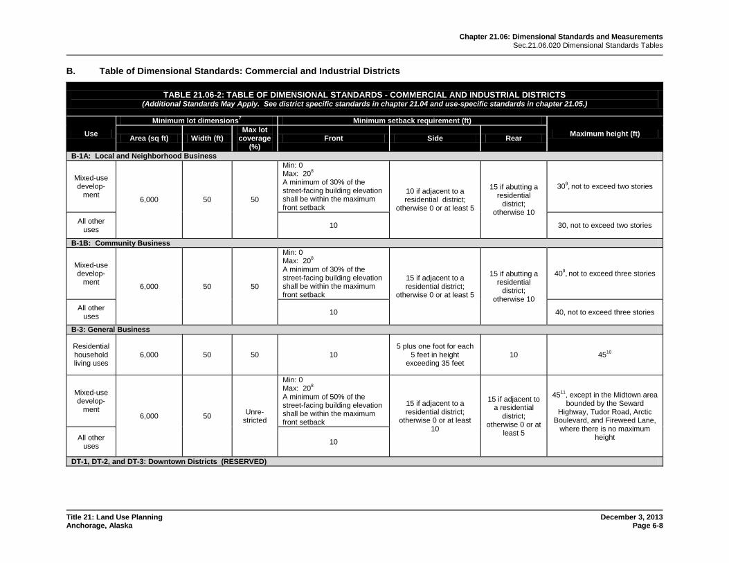
B. Table of Dimensional Standards: Commercial and Industrial Districts
TABLE 21.06-2: TABLE OF DIMENSIONAL STANDARDS - COMMERCIAL AND INDUSTRIAL DISTRICTS (Additional Standards May Apply. See district specific standards in chapter 21.04 and use-specific standards in chapter 21.05.)
Use
Minimum lot dimensions7 Minimum setback requirement (ft)
Maximum height (ft) Area (sq ft) Width (ft) Max lot
coverage (%)
Front Side Rear
B-1A: Local and Neighborhood Business
Mixed-use develop-
ment 6,000 50 50
Min: 0 Max: 208 A minimum of 30% of the street-facing building elevation shall be within the maximum front setback
10 if adjacent to a residential district;
otherwise 0 or at least 5
15 if abutting a residential
district; otherwise 10
309, not to exceed two stories
All other uses 10 30, not to exceed two stories
B-1B: Community Business
Mixed-use develop-
ment 6,000 50 50
Min: 0 Max: 208 A minimum of 30% of the street-facing building elevation shall be within the maximum front setback
15 if adjacent to a residential district;
otherwise 0 or at least 5
15 if abutting a residential
district; otherwise 10
409, not to exceed three stories
All other uses 10 40, not to exceed three stories
B-3: General Business
Residential household living uses
6,000 50 50 10 5 plus one foot for each
5 feet in height exceeding 35 feet
10 4510
Mixed-use develop-
ment 6,000 50 Unre-
stricted
Min: 0 Max: 208 A minimum of 50% of the street-facing building elevation shall be within the maximum front setback
15 if adjacent to a residential district;
otherwise 0 or at least 10
15 if adjacent to a residential
district; otherwise 0 or at
least 5
4511, except in the Midtown area bounded by the Seward
Highway, Tudor Road, Arctic Boulevard, and Fireweed Lane,
where there is no maximum height All other
uses 10
DT-1, DT-2, and DT-3: Downtown Districts (RESERVED)
Chapter 21.06: Dimensional Standards and Measurements Sec.21.06.020 Dimensional Standards Tables
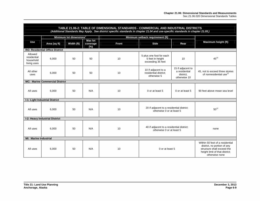
Title 21: Land Use Planning December 3, 2013 Anchorage, Alaska Page 6-9
TABLE 21.06-2: TABLE OF DIMENSIONAL STANDARDS - COMMERCIAL AND INDUSTRIAL DISTRICTS (Additional Standards May Apply. See district specific standards in chapter 21.04 and use-specific standards in chapter 21.05.)
Use
Minimum lot dimensions7 Minimum setback requirement (ft)
Maximum height (ft) Area (sq ft) Width (ft) Max lot
coverage (%)
Front Side Rear
RO: Residential Office District Allowed
residential household living uses
6,000 50 50 10 5 plus one foot for each
5 feet in height exceeding 35 feet
10 4510
All other uses 6,000 50 50 10
10 if adjacent to a residential district;
otherwise 5
15 if adjacent to a residential
district, otherwise 10
45, not to exceed three stories of nonresidential use12
MC: Marine Commercial District
All uses 6,000 50 N/A 10 0 or at least 5 0 or at least 5 90 feet above mean sea level
I-1: Light Industrial District
All uses 6,000 50 N/A 10 20 if adjacent to a residential district; otherwise 0 or at least 5 5013
I-2: Heavy Industrial District
All uses 6,000 50 N/A 10 40 if adjacent to a residential district; otherwise 0 or at least 5 none
MI: Marine Industrial
All uses 6,000 50 N/A 10 0 or at least 5
Within 50 feet of a residential district, no portion of any structure shall exceed the height limit of that district;
otherwise none
Chapter 21.06: Dimensional Standards and Measurements Sec.21.06.020 Dimensional Standards Tables
Title 21: Land Use Planning December 3, 2013 Anchorage, Alaska Page 6-10
TABLE 21.06-2: TABLE OF DIMENSIONAL STANDARDS - COMMERCIAL AND INDUSTRIAL DISTRICTS (Additional Standards May Apply. See district specific standards in chapter 21.04 and use-specific standards in chapter 21.05.)
Use
Minimum lot dimensions7 Minimum setback requirement (ft)
Maximum height (ft) Area (sq ft) Width (ft) Max lot
coverage (%)
Front Side Rear
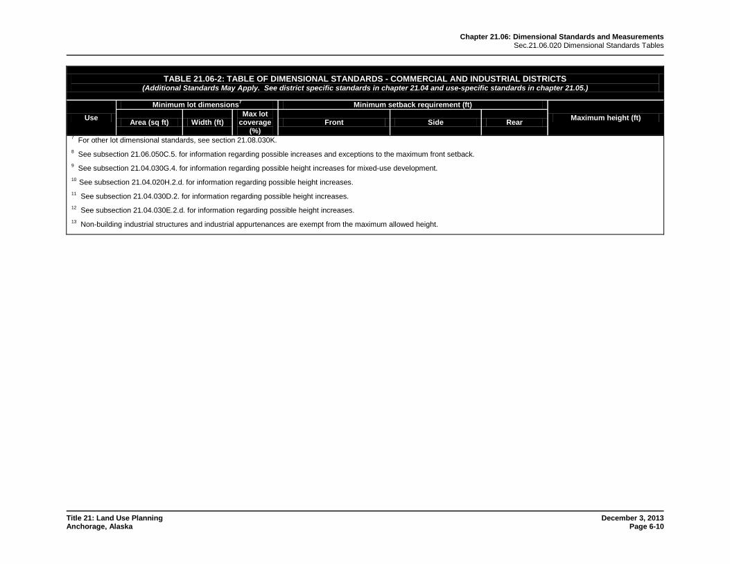
7 For other lot dimensional standards, see section 21.08.030K. 8 See subsection 21.06.050C.5. for information regarding possible increases and exceptions to the maximum front setback. 9 See subsection 21.04.030G.4. for information regarding possible height increases for mixed-use development. 10 See subsection 21.04.020H.2.d. for information regarding possible height increases. 11 See subsection 21.04.030D.2. for information regarding possible height increases. 12 See subsection 21.04.030E.2.d. for information regarding possible height increases. 13 Non-building industrial structures and industrial appurtenances are exempt from the maximum allowed height.
Chapter 21.06: Dimensional Standards and Measurements Sec.21.06.020 Dimensional Standards Tables
Title 21: Land Use Planning December 3, 2013 Anchorage, Alaska Page 6-11
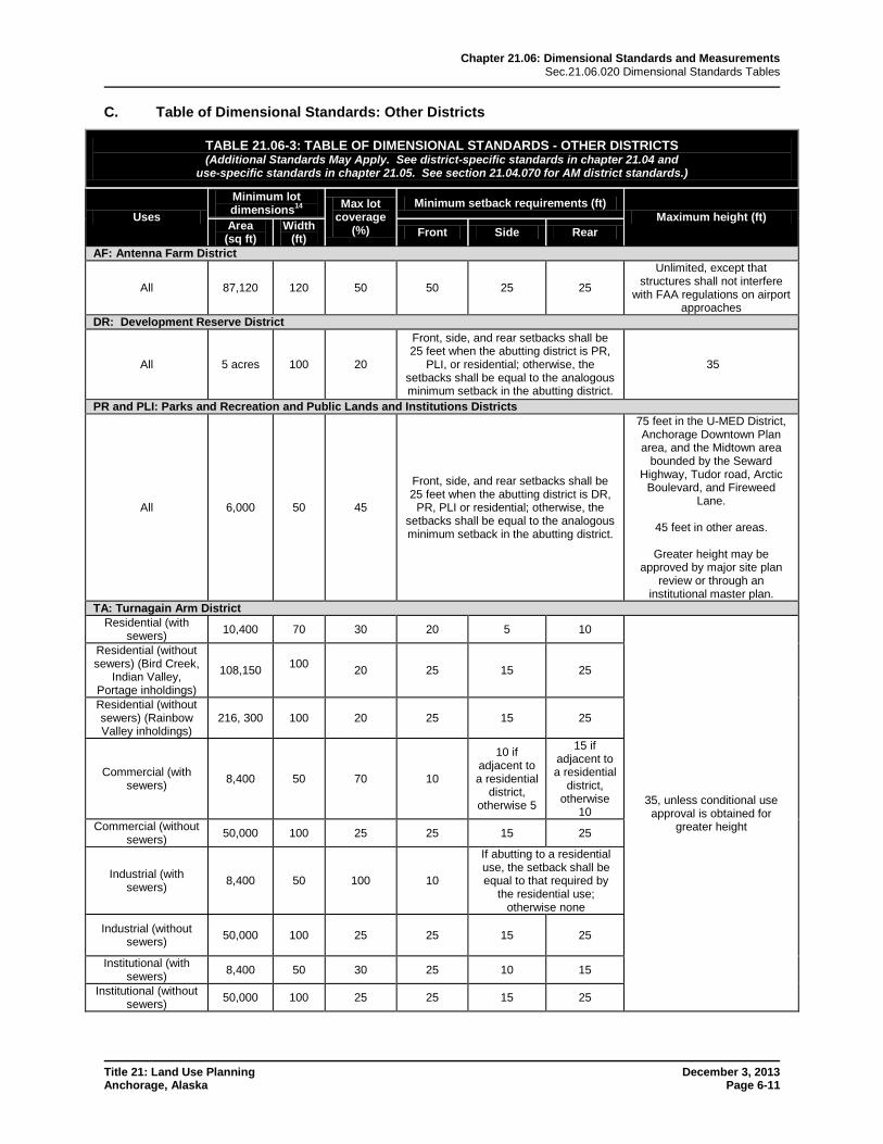
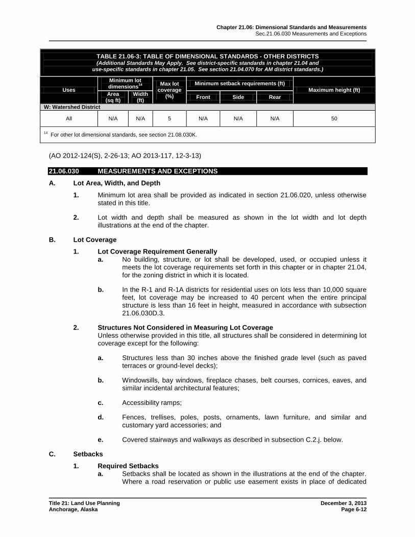
C. Table of Dimensional Standards: Other Districts
TABLE 21.06-3: TABLE OF DIMENSIONAL STANDARDS - OTHER DISTRICTS (Additional Standards May Apply. See district-specific standards in chapter 21.04 and
use-specific standards in chapter 21.05. See section 21.04.070 for AM district standards.)
Uses
Minimum lot dimensions14 Max lot
coverage (%)
Minimum setback requirements (ft) Maximum height (ft)
Area (sq ft)
Width (ft) Front Side Rear
AF: Antenna Farm District
All 87,120 120 50 50 25 25
Unlimited, except that structures shall not interfere
with FAA regulations on airport approaches
DR: Development Reserve District
All 5 acres 100 20
Front, side, and rear setbacks shall be 25 feet when the abutting district is PR,
PLI, or residential; otherwise, the setbacks shall be equal to the analogous minimum setback in the abutting district.
35
PR and PLI: Parks and Recreation and Public Lands and Institutions Districts
All 6,000 50 45
Front, side, and rear setbacks shall be 25 feet when the abutting district is DR,
PR, PLI or residential; otherwise, the setbacks shall be equal to the analogous minimum setback in the abutting district.
75 feet in the U-MED District, Anchorage Downtown Plan area, and the Midtown area
bounded by the Seward Highway, Tudor road, Arctic
Boulevard, and Fireweed Lane.
45 feet in other areas.
Greater height may be
approved by major site plan review or through an
institutional master plan. TA: Turnagain Arm District
Residential (with sewers) 10,400 70 30 20 5 10
35, unless conditional use approval is obtained for
greater height
Residential (without sewers) (Bird Creek,
Indian Valley, Portage inholdings)
108,150 100 20 25 15 25
Residential (without sewers) (Rainbow Valley inholdings)
216, 300 100 20 25 15 25
Commercial (with sewers) 8,400 50 70 10
10 if adjacent to a residential
district, otherwise 5
15 if adjacent to a residential
district, otherwise
10 Commercial (without
sewers) 50,000 100 25 25 15 25
Industrial (with sewers) 8,400 50 100 10
If abutting to a residential use, the setback shall be equal to that required by
the residential use; otherwise none
Industrial (without sewers) 50,000 100 25 25 15 25
Institutional (with sewers) 8,400 50 30 25 10 15
Institutional (without sewers) 50,000 100 25 25 15 25
Chapter 21.06: Dimensional Standards and Measurements Sec.21.06.030 Measurements and Exceptions
Title 21: Land Use Planning December 3, 2013 Anchorage, Alaska Page 6-12
TABLE 21.06-3: TABLE OF DIMENSIONAL STANDARDS - OTHER DISTRICTS (Additional Standards May Apply. See district-specific standards in chapter 21.04 and
use-specific standards in chapter 21.05. See section 21.04.070 for AM district standards.)
Uses
Minimum lot dimensions14 Max lot
coverage (%)
Minimum setback requirements (ft) Maximum height (ft)
Area (sq ft)
Width (ft) Front Side Rear
W: Watershed District
All N/A N/A 5 N/A N/A N/A 50
14 For other lot dimensional standards, see section 21.08.030K.
(AO 2012-124(S), 2-26-13; AO 2013-117, 12-3-13) 21.06.030 MEASUREMENTS AND EXCEPTIONS
A. Lot Area, Width, and Depth
1. Minimum lot area shall be provided as indicated in section 21.06.020, unless otherwise stated in this title.
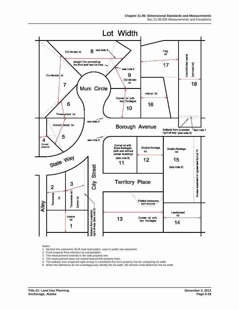
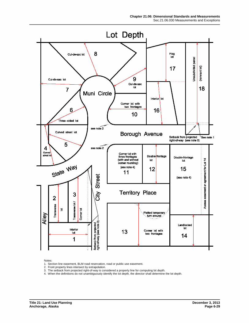
2. Lot width and depth shall be measured as shown in the lot width and lot depth illustrations at the end of the chapter.
B. Lot Coverage
1. Lot Coverage Requirement Generally a. No building, structure, or lot shall be developed, used, or occupied unless it
meets the lot coverage requirements set forth in this chapter or in chapter 21.04, for the zoning district in which it is located.
b. In the R-1 and R-1A districts for residential uses on lots less than 10,000 square feet, lot coverage may be increased to 40 percent when the entire principal structure is less than 16 feet in height, measured in accordance with subsection 21.06.030D.3.
2. Structures Not Considered in Measuring Lot Coverage Unless otherwise provided in this title, all structures shall be considered in determining lot coverage except for the following:
a. Structures less than 30 inches above the finished grade level (such as paved terraces or ground-level decks);
b. Windowsills, bay windows, fireplace chases, belt courses, cornices, eaves, and similar incidental architectural features;
c. Accessibility ramps;
d. Fences, trellises, poles, posts, ornaments, lawn furniture, and similar and customary yard accessories; and
e. Covered stairways and walkways as described in subsection C.2.j. below.
C. Setbacks
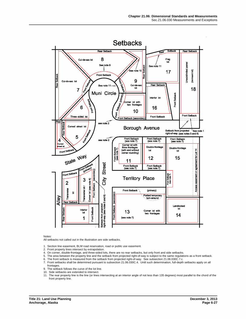
1. Required Setbacks a. Setbacks shall be located as shown in the illustrations at the end of the chapter.
Where a road reservation or public use easement exists in place of dedicated
Chapter 21.06: Dimensional Standards and Measurements Sec.21.06.030 Measurements and Exceptions
Title 21: Land Use Planning December 3, 2013 Anchorage, Alaska Page 6-13
street, the setback required by table 21.06-1 shall start at the edge of the setback from projected right-of-way required in subsection 21.06.030C.7. below.
b. A building, structure, or lot shall not be developed, used, or occupied unless it meets the setback requirements set forth in section 21.06.020 for the zoning district in which it is located, except as otherwise established in this title for particular uses, or unless a variance or minor modification has been granted.
c. Setbacks shall be unoccupied and unobstructed by any structure, except as provided in subsection C.2. below, and except that fences, walls, trellises, poles, posts, ornaments, furniture, and other customary yard accessories may be permitted in any setback subject to height limitations and requirements limiting obstruction of visibility.
d. A setback required by this title shall not be included as part of a setback required by this title for another building or structure or lot.
e. The entire “pole” portion of a flag lot shall be considered a front setback.
f. Where a setback is allowed to be zero feet, the setback shall be any inelastic response displacement distance required by title 23 to accommodate seismic deflection. A parapet cap, trim, or other similar cover shall cover any gap between buildings, in accordance with title 23.
2. Projections into Required Setbacks The following structures or features may project into required front, side, or rear setbacks as specified in this subsection:
a. Paved Terraces Paved terraces may project into any required setback, provided that no structures placed there shall violate other requirements of this title.
b. Unroofed Landings, Decks, and Stairs Except as provided in subsection 2.c. below, unroofed landings, decks, and stairs may project into required front and rear setbacks only, provided that no portion other than a handrail shall extend higher than 30 inches above the finished grade level.
c. Roofs Over Porches and Other Exterior Approaches Roofs over porches, stairways, landings, terraces, or other exterior approaches to pedestrian doorways may encroach up to five feet into a front setback, provided that, where such roof projections encroach within the setback, the roof projections shall comprise no more than 50 percent of the total length of a building’s front elevation. The covered porch or entrance area encroaching into the setback shall remain exterior to the building, and unenclosed or only partly enclosed, as by a handrail.
d. Incidental Architectural Features Windowsills, fireplace chases, belt courses, cornices, eaves, and similar incidental architectural features may project up to two feet into any required setback.
e. Bay Windows Bay windows, measuring no more than eight feet in width where the projection breaks the plane of the wall may project up to two feet into any required setback, so long as there is a minimum of eight feet between the bay window and any opposing encroachment on an adjacent lot.
Chapter 21.06: Dimensional Standards and Measurements Sec.21.06.030 Measurements and Exceptions
Title 21: Land Use Planning December 3, 2013 Anchorage, Alaska Page 6-14
f. Private Garage or Carport A private garage or carport may project into a required side or rear setback abutting an alley.
g. Accessory Structures Accessory structures may encroach into a required setback as allowed in subsection 21.05.070B.3.b. Refuse collection receptacles and their enclosures that are less than 150 square feet may encroach in any side or rear setback.
h. Accessibility Ramps The director may allow the installation of accessibility ramps with handrails in any required setback if they meet the following criteria:
i. There are no switchbacks over 30 inches in height; and
ii. The width of the ramp does not exceed 48 inches.
i. Fire Exits For buildings existing on January 1, 2014, open fire exits may project not more than four feet six inches into any required setback.
j. Covered Stairways and Walkways Stairways and walkways that are roofed but not fully enclosed, and are installed to provide public access between grade-separated areas, but are not intended to provide access to the entrance of any particular structure, may encroach into required setbacks.
3. Construction on Adjoining Lots In determining minimum setback requirements, each lot shall be determined individually and minimum setback requirements may not be calculated on the basis of two or more combined lots. In all instances where a building may be constructed immediately adjacent to a lot line, the building may be constructed upon or over such lot line, provided that the portion of the building on each individual lot is otherwise permitted on each lot.
4. Corner Lots with Two or More Frontages and Double-Frontage Lots a. In the case of corner lots with two or more frontages and double-frontage lots,
the director shall determine the setback requirements (except as provided in 4.b. below) subject to the following limitations:
i. At least one front setback shall be provided having the full depth required generally in the district.
ii. No other front setback on such lot shall have less than half the depth required generally for front setbacks in the district.
iii. For residential lots of less than one acre in area and for non-residential lots, setbacks shall be consistent with surrounding properties, with more weight given to abutting properties oriented in the same pattern.
b. For residential lots of one acre or greater in area, the property owner, with the concurrence of the traffic engineer, has discretion over which frontage shall be the primary front setback.
5. Maximum Setbacks Maximum setbacks are intended to help create an environment that is inviting to pedestrians and transit users, and a more active streetscape. Maximum setbacks promote buildings closer to the sidewalk and a stronger interface between buildings and adjoining streets, improving connectivity and making walking more convenient. The
Chapter 21.06: Dimensional Standards and Measurements Sec.21.06.030 Measurements and Exceptions
Title 21: Land Use Planning December 3, 2013 Anchorage, Alaska Page 6-15
requirements of this subsection provide for flexibility and creativity, and allow improvements to existing developments that do not meet the standard.
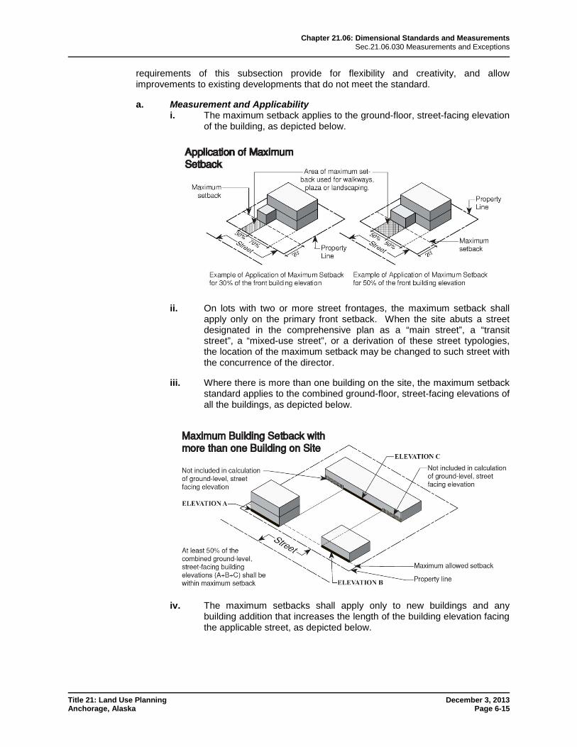
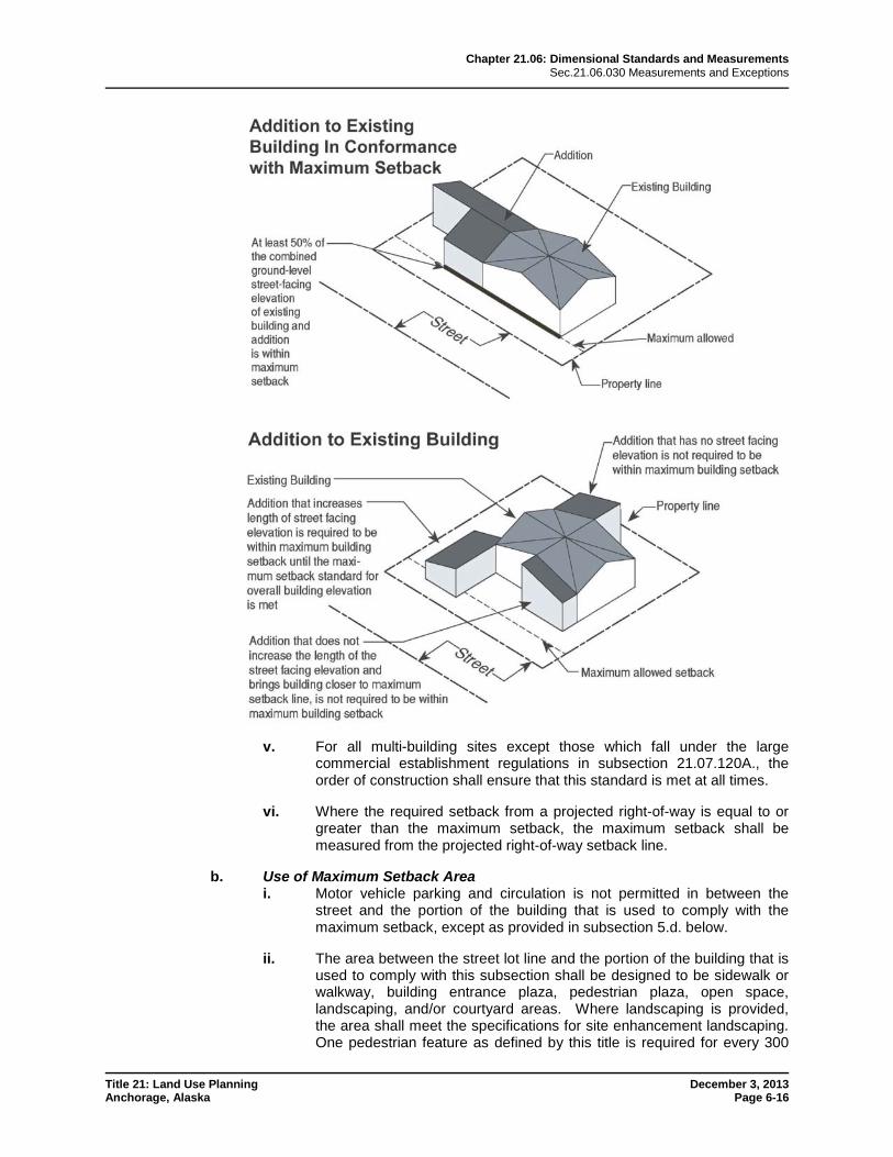
a. Measurement and Applicability i. The maximum setback applies to the ground-floor, street-facing elevation
of the building, as depicted below.
ii. On lots with two or more street frontages, the maximum setback shall apply only on the primary front setback. When the site abuts a street designated in the comprehensive plan as a “main street”, a “transit street”, a “mixed-use street”, or a derivation of these street typologies, the location of the maximum setback may be changed to such street with the concurrence of the director.
iii. Where there is more than one building on the site, the maximum setback standard applies to the combined ground-floor, street-facing elevations of all the buildings, as depicted below.
iv. The maximum setbacks shall apply only to new buildings and any building addition that increases the length of the building elevation facing the applicable street, as depicted below.
Chapter 21.06: Dimensional Standards and Measurements Sec.21.06.030 Measurements and Exceptions
Title 21: Land Use Planning December 3, 2013 Anchorage, Alaska Page 6-16
v. For all multi-building sites except those which fall under the large commercial establishment regulations in subsection 21.07.120A., the order of construction shall ensure that this standard is met at all times.
vi. Where the required setback from a projected right-of-way is equal to or greater than the maximum setback, the maximum setback shall be measured from the projected right-of-way setback line.
b. Use of Maximum Setback Area i. Motor vehicle parking and circulation is not permitted in between the
street and the portion of the building that is used to comply with the maximum setback, except as provided in subsection 5.d. below.
ii. The area between the street lot line and the portion of the building that is used to comply with this subsection shall be designed to be sidewalk or walkway, building entrance plaza, pedestrian plaza, open space, landscaping, and/or courtyard areas. Where landscaping is provided, the area shall meet the specifications for site enhancement landscaping. One pedestrian feature as defined by this title is required for every 300
Chapter 21.06: Dimensional Standards and Measurements Sec.21.06.030 Measurements and Exceptions
Title 21: Land Use Planning December 3, 2013 Anchorage, Alaska Page 6-17
square feet of maximum setback area. Parking facilities allowed under subsection 5.d. below are exempted.
c. General Exceptions to Maximum Setback i. The maximum front setback may be exceeded by up to 20 additional feet
(or more through administrative site plan review) if the additional area between the building and the property line is used to provide common open space that conforms to the standards of section 21.07.030, contains site enhancement landscaping, and/or contains pedestrian amenities as described in subsection 21.07.060F. The additional area shall not be developed for motor vehicle parking or driveways, loading or refuse collection, or ground-mounted utilities.
ii. For buildings where all the floor area is in residential use, the street-facing façade of a covered porch qualifies for meeting this standard. The porch shall have at least one entrance accessible from the street.
d. Specific Exceptions to Maximum Setback—Midrise and High-Rise Buildings For buildings in Midtown that exceed 60 feet in height and include five or more floors, the maximum front setback may be increased to a total distance of 90 feet and incorporate up to one vehicle circulation aisle and/or parking bay between the building and the street, subject to the following requirements and limitations, in order to reduce shadowing and allow for light, air, and views along urban corridors while also retaining pedestrian connections:
i. Development requesting the maximum setback increase shall be subject to administrative site plan review, unless a higher level of review is already required.
ii. Where an area or street has been designated for more restrictive setbacks in the comprehensive plan, such as in the Anchorage Downtown Comprehensive Plan, the more restrictive policies or standards shall govern.
iii. The building shall provide at least one primary entrance within 90 feet of the street or right-of-way, and connected to the street by a walkway that meets subsection 21.07.060F.4., Primary Pedestrian Walkway.
iv. A walkway or pedestrian areas shall be provided along the length of the street-facing building elevation fronting the parking and vehicle circulation area. Perimeter landscaping and sidewalk facilities meeting the requirements of this title shall be provided along the length of the street frontage between the street and the parking lot.
e. Exemptions The following uses are exempt from the maximum setback requirement:
i. Food and beverage kiosks;
ii. Fueling stations; and
iii. Vehicle service and repair, major or minor.
6. Setback from Planned Utility Transmission Facilities a. No new structural or land development activity requiring a building or land use
permit shall be permitted within the minimum area stated in the Utility Corridor Plan for planned electrical or telecommunication transmission facilities for which
Chapter 21.06: Dimensional Standards and Measurements Sec.21.06.030 Measurements and Exceptions
Title 21: Land Use Planning December 3, 2013 Anchorage, Alaska Page 6-18
there is a projected easement or right-of-way, except as allowed under 6.b., below.
b. The following uses and activities are permitted, with written acknowledgement of coordination with the affected utilities, within the setbacks described in 6.a., above:
i. Sidewalks, walkways, pathways, and trails;
ii. Bus shelters and bus turnouts;
iii. Kiosks and seating units;
iv. Utilities, utility easements and utility-related structures;
v. Landscaping required by section 21.07.080, Landscaping, Screening, and Fences, and consisting of ground cover, shrubs and understory trees whose maximum height does not exceed 30 feet;
vi. Surface parking required by section 21.07.090, Off-Street Parking and Loading;
vii. Temporary parking as described in section 21.05.080;
viii. Additional parking to that required by this title;
ix. Open space;
x. Fences and signs;
xi. Retaining walls;
xii. Remodeling of or addition to structures existing as of February 27, 1990, so long as it does not further intrude within the setback area after that date; and
xiii. Driveways and vehicular access points.
c. Applicable setback requirements stated elsewhere in this title may include the area of setback for electrical transmission facilities.
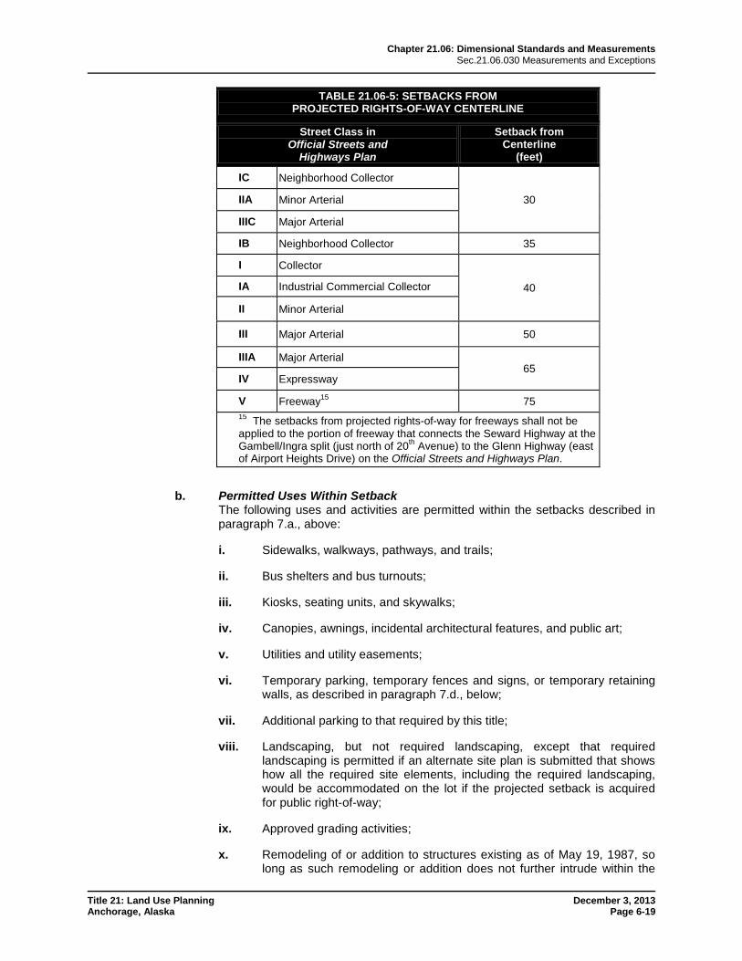
7. Setbacks from Projected Rights-of-Way a. Minimum Setback
Except as allowed under subsection 7.b. below, no new structural or land development activity requiring a building or land use permit shall be permitted within the minimum setback set forth in the table below from the existing or projected centerline of a street designated on the Official Streets and Highways Plan (OSHP), or within 30 feet (25 feet in class B districts) from the centerline of a road reservation or public use easement not so designated on the OSHP.
Chapter 21.06: Dimensional Standards and Measurements Sec.21.06.030 Measurements and Exceptions
Title 21: Land Use Planning December 3, 2013 Anchorage, Alaska Page 6-19
TABLE 21.06-5: SETBACKS FROM PROJECTED RIGHTS-OF-WAY CENTERLINE
Street Class in Official Streets and
Highways Plan
Setback from Centerline
(feet)
IC Neighborhood Collector
30 IIA Minor Arterial
IIIC Major Arterial
IB Neighborhood Collector 35
I Collector
40 IA Industrial Commercial Collector
II Minor Arterial
III Major Arterial 50
IIIA Major Arterial 65
IV Expressway
V Freeway15 75 15 The setbacks from projected rights-of-way for freeways shall not be applied to the portion of freeway that connects the Seward Highway at the Gambell/Ingra split (just north of 20th Avenue) to the Glenn Highway (east of Airport Heights Drive) on the Official Streets and Highways Plan.
b. Permitted Uses Within Setback The following uses and activities are permitted within the setbacks described in paragraph 7.a., above:
i. Sidewalks, walkways, pathways, and trails;
ii. Bus shelters and bus turnouts;
iii. Kiosks, seating units, and skywalks;
iv. Canopies, awnings, incidental architectural features, and public art;
v. Utilities and utility easements;
vi. Temporary parking, temporary fences and signs, or temporary retaining walls, as described in paragraph 7.d., below;
vii. Additional parking to that required by this title;
viii. Landscaping, but not required landscaping, except that required landscaping is permitted if an alternate site plan is submitted that shows how all the required site elements, including the required landscaping, would be accommodated on the lot if the projected setback is acquired for public right-of-way;
ix. Approved grading activities;
x. Remodeling of or addition to structures existing as of May 19, 1987, so long as such remodeling or addition does not further intrude within the
Chapter 21.06: Dimensional Standards and Measurements Sec.21.06.030 Measurements and Exceptions
Title 21: Land Use Planning December 3, 2013 Anchorage, Alaska Page 6-20
setback area or increase the floor area of the structure within the setback area; and
xi. Driveways and vehicular access.
c. Additional Setback Requirements Applicable setback requirements stated elsewhere in this chapter shall be in addition to those stated in this subsection 21.06.030C.7.
d. Temporary Features As used in this subsection 21.06.030C.7.d., the term "temporary" or "temporarily" means that period of time between the issuance of a building or land use permit and the right of entry conveyed to the municipality or other government entity for a road project that affects the setback area required by this subsection 21.06.030C.7.d. Parking, fences and signs, and retaining walls required by this title may be provided temporarily within a setback area described in this subsection 21.06.030C.7.d. only if the director and the traffic engineer first find that:
i. The temporary features to be used on the lot conform to all other applicable requirements of this title;
ii. An alternate site plan has been submitted with an application for a building or land use permit for permanent required features on the lot, excluding all setback areas thereon, in conformance with all applicable requirements of this title; and
iii. An agreement between the owner of the lot and the municipality has been executed and recorded so as to give notice of the temporary requirements to be applied to the lot and of the date or event by which the temporary features shall be abandoned in favor of the permanent configuration stated in the alternate site plan.
8. Sight Distance Triangles Sight distance triangles shall be unobstructed as required by the traffic engineer.
D. Height
1. Allowable Height The maximum allowable height for buildings and structures in each district shall be as provided in section 21.06.020, Dimensional Standards Tables, except where specifically modified by this subsection D. and/or other provisions of this title.
2. Airport Height Regulations Nothing in this section allows a building, structure, or appurtenance to exceed the height limitations of the airport height regulations (21.06.030D.9.).
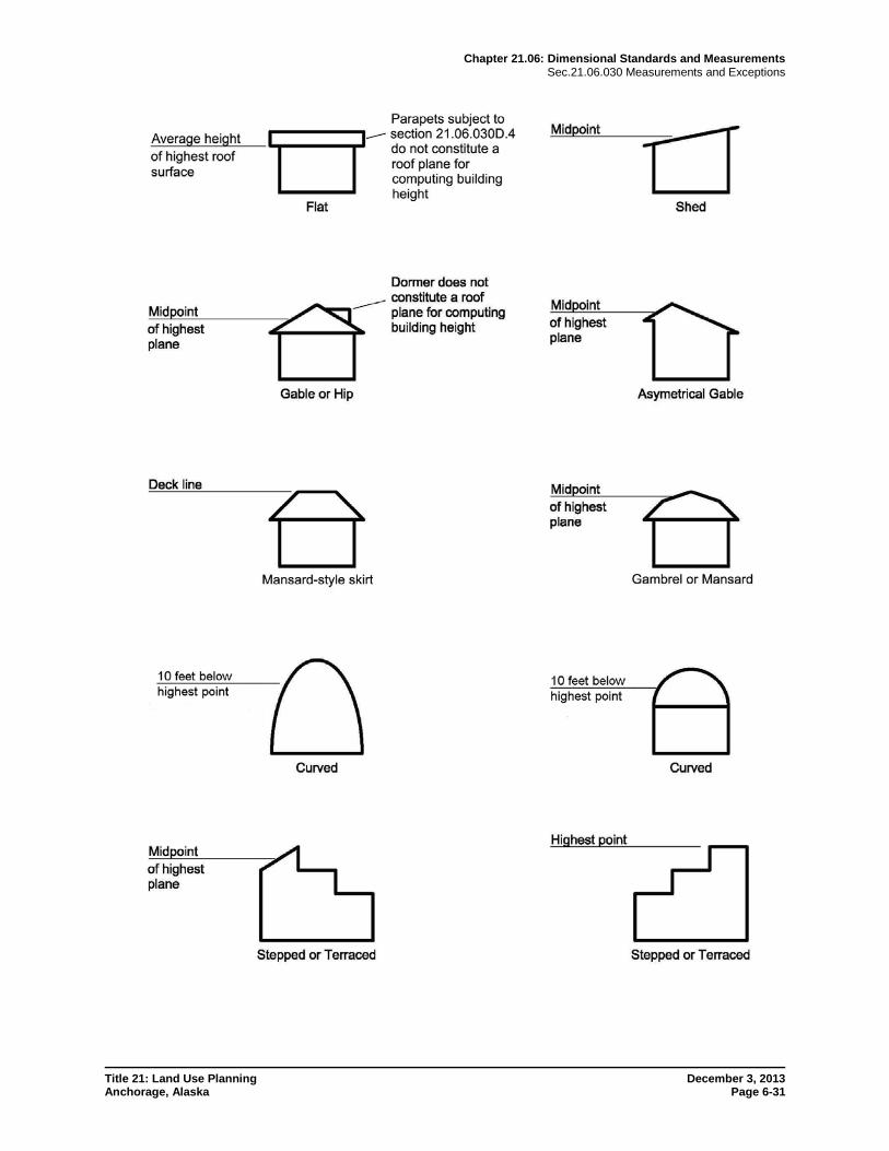
3. Rules for Measuring Height a. Building height for most building types shall be measured as the vertical distance
from grade plane to the midpoint (median height) of the highest roof surface, as shown in the illustration at the end of the chapter, subject to D.4. and D.5. below. Exceptions for curved roof surfaces are illustrated at the end of the chapter.
b. Structures that are not buildings shall be measured as the vertical distance from grade plane to the highest point of the structure. Fences on top of retaining walls shall be measured from grade plane on the highest side of the retaining wall.
Chapter 21.06: Dimensional Standards and Measurements Sec.21.06.030 Measurements and Exceptions
Title 21: Land Use Planning December 3, 2013 Anchorage, Alaska Page 6-21
c. Where tables 21.06-1 and 21.06-2 measure maximum height in terms of stories, any story below grade plane shall be excluded from calculation of the number of stories for determining building height.
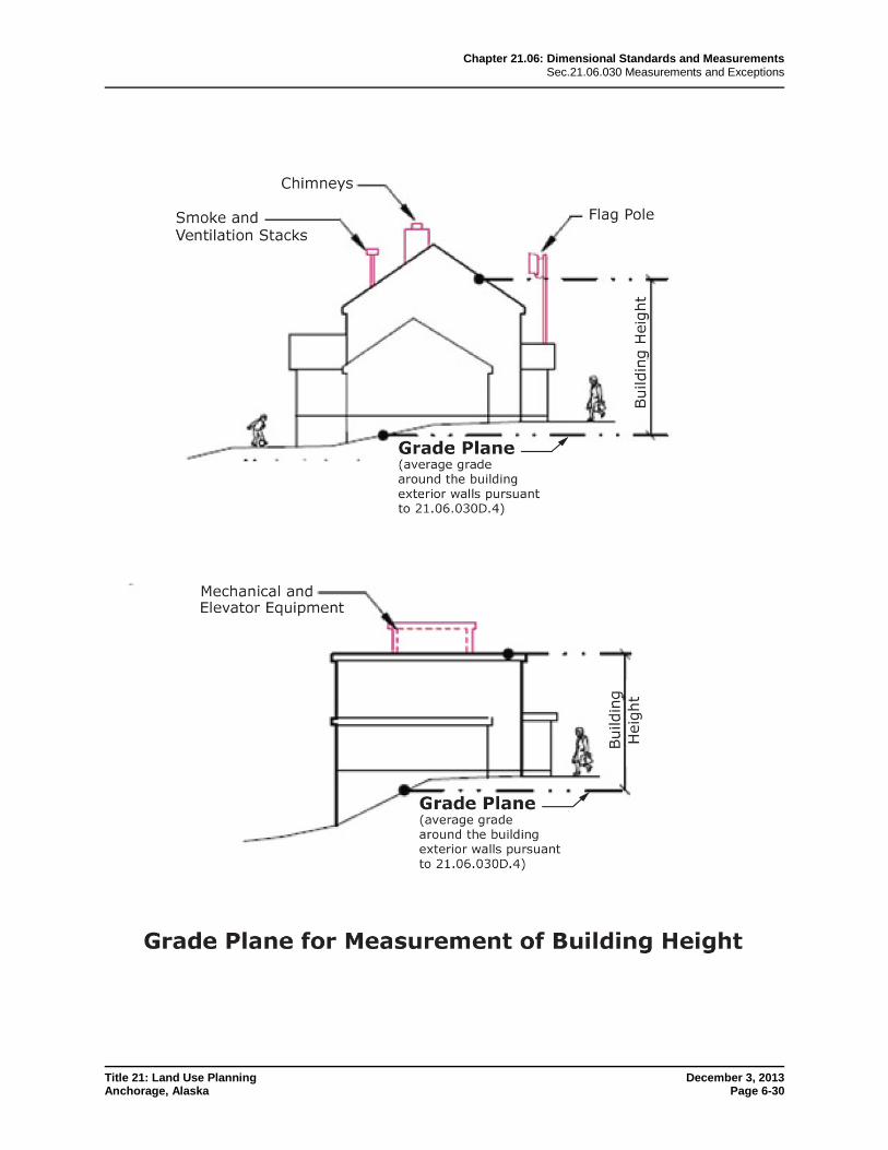
4. Grade Plane The grade plane for determination of structure height shall be the average of existing or finished grade, whichever is lower, abutting the structure at exterior walls. Where the grade slopes away from the exterior walls, the grade plane shall be established by the lowest points within the area between the building and the lot line, or, where the lot line is more than six feet from the building, between the building and a point six feet from the building.
5. Establishment of Grade The grade plane shall be calculated using the more restrictive of either the existing grade or the finished grade.
a. Existing Grade In no case shall the existing grade be altered by grading, such as an artificial embankment or where the ground has been built up to increase the grade around the building, to obtain a higher structure than is otherwise permitted in the district.
b. Adjustments to Establishment of Grade In a case where existing grade or finished grade is, in the judgment of the director, inappropriate or unworkable for the purpose of measuring height, the director shall establish grade in such a way as to be consistent with this section. The proposed grade being requested by the applicant shall be, in the judgment of the director, reasonable and comparable with the grades of surrounding properties and streets; not detrimental to the general health, safety, and welfare; not result in the loss of any public views; consistent with the existing character of the neighborhood; and necessary for the preservation and enjoyment of substantial property rights of the applicant.
6. Height Exceptions a. Free-standing flag poles shall conform to the height restrictions of the principal
structure, rather than an accessory structure.
b. Window wells, light wells, cellar or basement access walkways serving a dwelling unit, and similar appurtenances installed below grade with an inside dimension of 120 square feet or less (including stairs) and that do not exceed in length 25 percent of the building elevation wall shall be excluded from calculation of grade plane for determining building height.
c. Except as specifically provided elsewhere in this title, the height limitations contained in this chapter do not apply to appurtenances on buildings, such as spires and similar religious appurtenances, belfries, cupolas, flagpoles, chimneys, antennas, rooftop mechanical equipment and its screening, stairwell towers, elevator penthouses, parapets, firewalls, open or transparent railings, solar reflectors, photovoltaic panels, skylights, or similar appurtenances; provided, however, the following:
i. The appurtenance does not interfere with Federal Aviation Regulations, Part 77, Objects Affecting Navigable Airspace;
ii. The appurtenances cumulatively cover no more than one-third of the roof area of the building, except that when it has been demonstrated to the director and the building official that building HVAC requirements necessitate a larger mechanical penthouse, the appurtenances may cumulatively cover up to one-half of the roof area;
Chapter 21.06: Dimensional Standards and Measurements Sec.21.06.030 Measurements and Exceptions
Title 21: Land Use Planning December 3, 2013 Anchorage, Alaska Page 6-22
iii. The appurtenance is not constructed for the purpose of providing additional floor area, usable space, or storage room for the building, except that a storage room of 60 square feet or less, combined with a stairwell tower or elevator housing, and directly related to a rooftop use (such as tool storage for a rooftop garden), is allowed; and
iv. The appurtenance does not exceed the height limit of the district by more than 15 feet, with the following exceptions:
(A) The allowed height of high voltage transmission towers is addressed in subsection 21.05.040J.1.
(B) The allowed height of antennas and other telecommunications infrastructure is addressed in subsection 21.05.040K.;
(C) Flagpoles and spires and similar religious appurtenances may exceed up to 30 feet in residential districts and up to 50 feet in nonresidential districts;
(D) Elevator penthouses may exceed up to 25 feet;
(E) Parapets, firewalls, and skylights may exceed up to four feet.
7. Height Adjustments Commercial buildings sometimes feature a greater ceiling height on the first floor to enhance the building’s aesthetic appeal and openness of ground-floor retail spaces. Building height shall be allowed to be increased by up to five feet above the height limit for the district, provided that the increase is only to allow a greater first story height for ground level commercial use, and the increase in height does not result in a greater number of stories than would otherwise be constructed.
8. Height Transitions for Neighborhood Compatibility a. Purpose
The objective of the height transition standard is to help ensure compatibility between higher intensity development and adjacent lower density residential districts, in terms of building bulk and scale, a degree of sunlight access and ambient daylighting, and the potential for privacy and visual buffering. The standard is not designed to reduce the gross floor area development potential of a subject lot; instead, it is intended to encourage thoughtful positioning of building massing and height on the subject lot with respect to adjacent neighborhoods.
b. Applicability This standard shall apply to structures located in any non-residential district (except for the DT districts), the R-4 district, or the R-4A district, that is within 200 feet of any lot zoned R-1, R-1A, R-2A, R-2D, R-2M, R-3, R-5, R-6, R-7, R-8, R-9, or R-10.
c. Standard Structures on the subject lot shall not penetrate a daylight plane that rises inward over the subject lot at an angle of five feet of run for every three feet of rise, and starting from a height of 15 feet above existing grade at the nearest lot line of the residential (protected) lot. The standard may be met using one or more of the following options:
i. Compatible placement of a tall building on the subject lot with respect to the residential neighborhood, by shifting the location of the building to be further away from the adjacent residential property, and providing space for parking facilities or other site elements in the space in-between;
Chapter 21.06: Dimensional Standards and Measurements Sec.21.06.030 Measurements and Exceptions
Title 21: Land Use Planning December 3, 2013 Anchorage, Alaska Page 6-23
ii. Compatible massing of a tall building, such as a step-back in building form, by arranging the building mass so that the lower part is closer and the taller part is further away from the adjacent residential property; and/or
iii. Compatible height transition that meets the intent of the section through an alternative design and/or placement, using the procedure and criteria of section 21.07.010D., Alternative Equivalent Compliance.
d. Exceptions i. Height exceptions in subsection D.6. above that have a width of 20 feet
or less facing the residential lot are not subject to the height transitions standard.
ii. The director may exempt any portion of a proposed development which, being already completely blocked from the protected property by existing permanent structures or topography, will have no additional impact.
iii. The director may exempt a proposed development if, because of topography or lot dimensions or configuration, the height transitions provisions would unduly restrict permissible development, and reasonable use cannot otherwise be made of the site of the proposed development.
iv. Exceptions shall be the minimal action that would afford relief and shall cause the least interference possible with the intended protections for the residential lots.
9. Airport Height Regulations a. Purpose
The purpose of the airport height overlay district is to regulate the height of buildings and structures to prevent interference between land uses and air traffic. It is intended to be in accordance with the Federal Aviation Regulations (FAR).
b. Specific Airport Height Maps Adopted The following airport height zone maps are adopted and thus the referenced areas are located within the airport height overlay district:
i. The airport height zoning map prepared for the Birchwood Airport in the municipality (most recently adopted version).
ii. The airport height zoning map prepared for the Girdwood Airport in the municipality (most recently adopted version).
iii. The airport height zoning map prepared for the Ted Stevens Anchorage International Airport in the municipality (most recently adopted version).
iv. The Airport Height Zoning Map prepared for the Merrill Field Airport in the municipality (most recently adopted version).
c. Establishment or Modification In addition to the standard submittals required to initiate an overlay map amendment pursuant to section 21.03.160H., establishment of an airport height overlay district also shall require preparation of an airport height map as set forth in this section:
i. The owner or manager of any airport may prepare an airport height map in accordance with the provisions of this subsection and the stipulations
Chapter 21.06: Dimensional Standards and Measurements Sec.21.06.030 Measurements and Exceptions
Title 21: Land Use Planning December 3, 2013 Anchorage, Alaska Page 6-24
of FAR part 77, subpart C, paragraph 77.23(A)(2), 77.23(A)(3) or 77.25. The owner or manager of a governmentally operated airport shall prepare and maintain an airport height map in accordance with FAR part 77, subpart C, paragraph 77.25. The map shall be filed with the department.
ii. The map shall be to scale and shall accurately reference the following:
(A) Existing subdivisions.
(B) Current zoning districts.
(C) Major reference points in the vicinity of the airstrip or airport.
(D) Existing topography, if available.
(E) The airport elevation that shall be the official elevation of the airport or airstrip upon approval of the map.
iii. The map required by paragraph a. above, shall accurately depict airspace zones as provided in FAR part 77, subpart C, paragraph 77.25, in ten-foot conical increments. Before submission to the Department the map shall be certified by the Federal Aviation Administration that it depicts the requirements of FAR part 77, subpart C, paragraph 77.25. If, for safety reasons, zone surfaces deviate in any way from the requirements of the FAR, each such deviation shall be indicated in writing on the map and shall be accompanied by a letter of nonobjection by the Federal Aviation Administration. Any such deviation is subject to approval of the department.
iv. Before submission to the department any optional map depicting airspace zones provided in FAR part 77, subpart C, paragraph 77.23(A)(2) or 77.23(A)(3), must be certified by the Federal Aviation Administration indicating that it accurately depicts the requirements of FAR part 77, subpart C, subsection 77.23(A)(2) or 77.23(A)(3).
d. Additional Height Limitations in Airport Height Overlay District Notwithstanding the height limitations in section 21.06.020, Dimensional Standards Tables, in subsection 21.09.060B., Dimensional Standards Tables (Girdwood), and in subsection 21.10.060C., Dimensional Standards Tables (Chugiak-Eagle River), all development within the airport height overlay district shall comply with the following height limitations:
i. No structure shall be constructed or maintained so that it exceeds the greater of:
(A) Thirty-five feet above ground elevation; or
(B) The maximum height permitted under FAR part 77, subpart C, as depicted on any airport height zone map adopted under section 21.04.080.C., Airport Height Overlay District.
ii. Any structure within three nautical miles of an airport reference point established by federal regulation, the height of which exceeds the level of that reference point by more than 200 feet, shall present to the building official the results of an airspace determination conducted by the Federal Aviation Administration pursuant to its regulations.
Chapter 21.06: Dimensional Standards and Measurements Sec.21.06.030 Measurements and Exceptions
Title 21: Land Use Planning December 3, 2013 Anchorage, Alaska Page 6-25
iii. The height restrictions of this district do not apply to buildings for which building or land use permits were issued prior to June 17, 1986.
iv. Vegetation shall not be affected by the height limitation of this section.
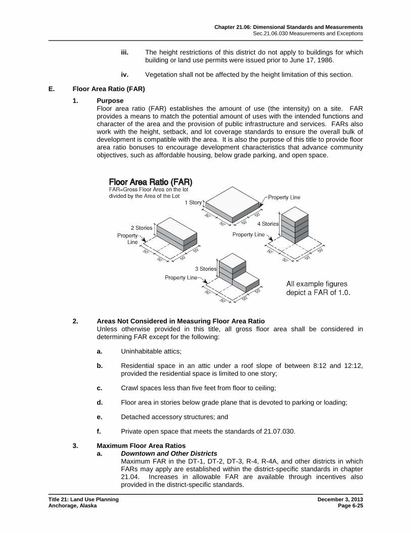
E. Floor Area Ratio (FAR)
1. Purpose Floor area ratio (FAR) establishes the amount of use (the intensity) on a site. FAR provides a means to match the potential amount of uses with the intended functions and character of the area and the provision of public infrastructure and services. FARs also work with the height, setback, and lot coverage standards to ensure the overall bulk of development is compatible with the area. It is also the purpose of this title to provide floor area ratio bonuses to encourage development characteristics that advance community objectives, such as affordable housing, below grade parking, and open space.
2. Areas Not Considered in Measuring Floor Area Ratio Unless otherwise provided in this title, all gross floor area shall be considered in determining FAR except for the following:
a. Uninhabitable attics;
b. Residential space in an attic under a roof slope of between 8:12 and 12:12, provided the residential space is limited to one story;
c. Crawl spaces less than five feet from floor to ceiling;
d. Floor area in stories below grade plane that is devoted to parking or loading;
e. Detached accessory structures; and
f. Private open space that meets the standards of 21.07.030.
3. Maximum Floor Area Ratios a. Downtown and Other Districts
Maximum FAR in the DT-1, DT-2, DT-3, R-4, R-4A, and other districts in which FARs may apply are established within the district-specific standards in chapter 21.04. Increases in allowable FAR are available through incentives also provided in the district-specific standards.
Chapter 21.06: Dimensional Standards and Measurements Sec.21.06.030 Measurements and Exceptions
Title 21: Land Use Planning December 3, 2013 Anchorage, Alaska Page 6-26
b. FAR Bonus Review An administrative site plan review shall be conducted on all developments proposed for a floor area ratio bonus, unless exempted in writing by the director or a higher level of review is required.
c. FAR Bonus Agreement Where a special feature is to be provided in order to receive an FAR bonus, the owner shall enter into a written agreement with the municipality ensuring the continued provision of the special feature for as long as the development uses the FAR bonus. The municipality shall record the agreement at the district recorder’s office as a covenant running with the land, binding upon the owner and all successors and assigns, and enforceable by the municipality. Recordation of the agreement shall take place prior to the issuance of any entitlement for the development.
(AO 2012-124(S), 2-26-13; AO 2013-117, 12-3-13)
Chapter 21.06: Dimensional Standards and Measurements Sec.21.06.030 Measurements and Exceptions
Title 21: Land Use Planning December 3, 2013 Anchorage, Alaska Page 6-27
Notes: All setbacks not called out in the illustration are side setbacks. 1. Section line easement, BLM road reservation, road or public use easement. 2. Front property lines intersect by extrapolation. 4. On corner, double-frontage, and three-sided lots, there are no rear setbacks, but only front and side setbacks. 5. The area between the property line and the setback from projected right-of-way is subject to the same regulations as a front setback. 6. The front setback is measured from the setback from projected right-of-way. See subsection 21.06.030C.7.c. 7. Front setbacks shall be determined pursuant to subsection 21.06.030C.4. Until such determination, full-depth setbacks apply on all frontages. 9. The setback follows the curve of the lot line. 10. Side setbacks are extended to intersect. 11. The rear property line is the line (or lines intersecting at an interior angle of not less than 135 degrees) most parallel to the chord of the front property line.
Chapter 21.06: Dimensional Standards and Measurements Sec.21.06.030 Measurements and Exceptions
Title 21: Land Use Planning December 3, 2013 Anchorage, Alaska Page 6-28
Notes: 1. Section line easement, BLM road reservation, road or public use easement. 2. Front property lines intersect by extrapolation. 3. The measurement extends to the side property line. 4. The measurement does not extend beyond the property lines. 5. The setback from projected right-of-way is considered the front property line for computing lot width. 6. When the definitions do not unambiguously identify the lot width, the director shall determine the lot width.
Chapter 21.06: Dimensional Standards and Measurements Sec.21.06.030 Measurements and Exceptions
Title 21: Land Use Planning December 3, 2013 Anchorage, Alaska Page 6-29
Notes: 1. Section line easement, BLM road reservation, road or public use easement. 2. Front property lines intersect by extrapolation. 3. The setback from projected right-of-way is considered a property line for computing lot depth. 4. When the definitions do not unambiguously identify the lot depth, the director shall determine the lot depth.
Chapter 21.06: Dimensional Standards and Measurements Sec.21.06.030 Measurements and Exceptions
Title 21: Land Use Planning December 3, 2013 Anchorage, Alaska Page 6-30
Chapter 21.06: Dimensional Standards and Measurements Sec.21.06.030 Measurements and Exceptions
Title 21: Land Use Planning December 3, 2013 Anchorage, Alaska Page 6-31