Chapter 2 – Geophysical Operations book/Chapt 2 - Geophysical.pdf · Surface Operating Standards...
2
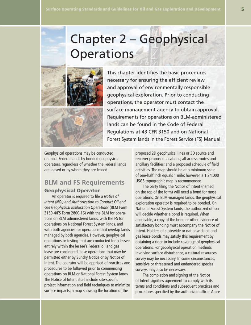
Surface Operating Standards and Guidelines for Oil and Gas Exploration and Development Chapter 2 – Geophysical Operations This chapter identifies the basic procedures necessary for ensuring the efficient review and approval of environmentally responsible geophysical exploration. Prior to conducting operations, the operator must contact the surface management agency to obtain approval. Requirements for operations on BLM-administered lands can be found in the Code of Federal Regulations at 43 CFR 3150 and on National Forest System lands in the Forest Service (FS) Manual. Geophysical operations may be conducted on most Federal lands by bonded geophysical operators, regardless of whether the Federal lands are leased or by whom they are leased. BLM and FS Requirements Geophysical Operator An operator is required to file a Notice of Intent (NOI) and Authorization to Conduct Oil and Gas Geophysical Exploration Operations (BLM Form 3150-4/FS Form 2800-16) with the BLM for opera- tions on BLM administered lands, with the FS for operations on National Forest System lands, and with both agencies for operations that overlap lands managed by both agencies. However, geophysical operations or testing that are conducted for a lessee entirely within the lessee’s Federal oil and gas lease are considered lease operations that may be permitted either by Sundry Notice or by Notice of Intent. The operator will be apprised of practices and procedures to be followed prior to commencing operations on BLM or National Forest System lands. The Notice of Intent shall include site-specific project information and field techniques to minimize surface impacts; a map showing the location of the proposed 2D geophysical lines or 3D source and receiver proposed locations; all access routes and ancillary facilities; and a proposed schedule of field activities. The map should be at a minimum scale of one-half inch equals 1 mile; however, a 1:24,000 USGS topographic map is recommended. The party filing the Notice of Intent (named on the top of the form) will need a bond for most operations. On BLM-managed lands, the geophysical exploration operator is required to be bonded. On National Forest System lands, the authorized officer will decide whether a bond is required. When applicable, a copy of the bond or other evidence of satisfactory bonding must accompany the Notice of Intent. Holders of statewide or nationwide oil and gas lease bonds may satisfy this requirement by obtaining a rider to include coverage of geophysical operations. For geophysical operation methods involving surface disturbance, a cultural resources survey may be necessary. In some circumstances, sensitive or threatened and endangered species surveys may also be necessary. The completion and signing of the Notice of Intent signifies agreement to comply with its terms and conditions and subsequent practices and procedures specified by the authorized officer. A pre-
Transcript of Chapter 2 – Geophysical Operations book/Chapt 2 - Geophysical.pdf · Surface Operating Standards...
Surface Operating Standards and Guidelines for Oil and Gas Exploration and Development �
Chapter 2 – Geophysical Operations
This chapter identifies the basic procedures
necessary for ensuring the efficient review
and approval of environmentally responsible
geophysical exploration. Prior to conducting
operations, the operator must contact the
surface management agency to obtain approval.
Requirements for operations on BLM-administered
lands can be found in the Code of Federal
Regulations at 43 CFR 3150 and on National
Forest System lands in the Forest Service (FS) Manual.
Geophysical operations may be conducted on most Federal lands by bonded geophysical operators, regardless of whether the Federal lands are leased or by whom they are leased.
BLM and FS RequirementsGeophysical Operator
An operator is required to file a Notice of Intent (NOI) and Authorization to Conduct Oil and Gas Geophysical Exploration Operations (BLM Form 3150-4/FS Form 2800-16) with the BLM for opera-tions on BLM administered lands, with the FS for operations on National Forest System lands, and with both agencies for operations that overlap lands managed by both agencies. However, geophysical operations or testing that are conducted for a lessee entirely within the lessee’s Federal oil and gas lease are considered lease operations that may be permitted either by Sundry Notice or by Notice of Intent. The operator will be apprised of practices and procedures to be followed prior to commencing operations on BLM or National Forest System lands. The Notice of Intent shall include site-specific project information and field techniques to minimize surface impacts; a map showing the location of the
proposed 2D geophysical lines or 3D source and receiver proposed locations; all access routes and ancillary facilities; and a proposed schedule of field activities. The map should be at a minimum scale of one-half inch equals 1 mile; however, a 1:24,000 USGS topographic map is recommended.
The party filing the Notice of Intent (named on the top of the form) will need a bond for most operations. On BLM-managed lands, the geophysical exploration operator is required to be bonded. On National Forest System lands, the authorized officer will decide whether a bond is required. When applicable, a copy of the bond or other evidence of satisfactory bonding must accompany the Notice of Intent. Holders of statewide or nationwide oil and gas lease bonds may satisfy this requirement by obtaining a rider to include coverage of geophysical operations. For geophysical operation methods involving surface disturbance, a cultural resources survey may be necessary. In some circumstances, sensitive or threatened and endangered species surveys may also be necessary.
The completion and signing of the Notice of Intent signifies agreement to comply with its terms and conditions and subsequent practices and procedures specified by the authorized officer. A pre-

Surface Operating Standards and Guidelines for Oil and Gas Exploration and Development�
work field conference is recommended and may be conducted by the surface management agency. Earth moving equipment shall not be used without prior approval. Upon completion of operations, including
Authorized OfficerThe authorized officer will contact the operator
after the Notice of Intent (BLM Form 3150-4/FS Form 2800-16) is filed and inform the operator of the practices and procedures to be followed and the estimated time frame for approval. On National Forest System lands, a user fee will be assessed for operations on Federal lands that are not under lease by the operator.
The authorized officer will complete a final post-work inspection of the site and notify the operator that the terms and conditions of the Notice of Intent have been met or that additional action is required by the operator. Consent to release the
Articulated vibroseis trucks are one of many geophysical exploration methods.
bond or terminate liability will not be granted by the surface management agency until the operator has met the terms and conditions of the Notice of Intent.
Split Estate Minerals Administered by the BLM
Where the minerals are federally owned and the surface is privately or State owned, no authorization is necessary from the Federal Government to con-duct geophysical operations. Operators must work with the surface owner to obtain access to private lands and the State permitting agency for authoriza-tion of operations proposed on State lands.
any required reclamation, the operator is required to file a Notice of Completion (NOC) of Oil and Gas Geophysical Exploration Operations (BLM Form 3150-5/FS Form 2800-16a).