Chapter 11: Lighting, Thunder, and Tornadoesyu/class/ess5/Chapter.11.lighting.all.pdf · Tornadoes...
37
Chapter 11: Lighting, Thunder, and Tornadoes Chapter 11: Lighting, Thunder, and Tornadoes Lighting Thunder Tornadoes
Transcript of Chapter 11: Lighting, Thunder, and Tornadoesyu/class/ess5/Chapter.11.lighting.all.pdf · Tornadoes...

ESS5Prof. Jin-Yi Yu
Chapter 11: Lighting, Thunder, and TornadoesChapter 11: Lighting, Thunder, and Tornadoes
LightingThunderTornadoes

ESS5Prof. Jin-Yi Yu
LightingLighting
Cloud-to-Cloud Lighting80% of all lightingElectricity discharge happens within cloudsCauses the sky to light up uniformly (sheet lighting)
Cloud-to-Ground Lighting20% of all lightingElectricity discharge happens between cloud base and ground
ESS5Prof. Jin-Yi Yu
Major Sequence for LightingMajor Sequence for Lighting
Electrification of a cloud: Charge Separation
Development of a path through which the electrons can flow
Discharge: Lighting

ESS5Prof. Jin-Yi Yu
Charge Separation in CloudsCharge Separation in Clouds
Positive charges in the upper portions of the cloud; Negatively charges in lower portions; Small packet of positive charges in the cloud base.Lighting occurs in only in clouds that extend above the freezing level charge separation is related to ice crystals.Lighter crystals collide with heavy hailstones in the cloud.The lighter crystals are positively charged and move to upper portions of the cloud.The heavy hail stones are negatively charged and move to the lower portion of the cloud.

ESS5Prof. Jin-Yi Yu
Positively Charged GroundPositively Charged Ground
The negative charge at the bottom of the cloud causes a region of the ground beneath it to become negatively charged.
The positive charge is most dense on protruding objects, such as trees, poles, and buildings.

ESS5Prof. Jin-Yi Yu
Step LeadersStep LeadersThe dry air is a good electrical insulator, so a flow of current can not occur.
For cloud-to-ground lightning to occur, a stepped-leader must emanate from the cloud base.
The leader is essentially an ionized particle chamber about 10 cm (4 in) in diameter which forks repeatedly from a main channel.
Each section travels about 50 m in a microsecond.
The sections continue until contact is made with an unlike charged area (the ground).

ESS5Prof. Jin-Yi Yu
Return StrokesReturn Strokes
Upon connection, electrons flow resulting in an illuminated return stroke.
Although the electrical current is from the cloud to the ground (moves downward), the return stroke is in the opposite direction (move upward).
The upward return stroke happens so fast, our eyes can not resolve its upward direction.
ESS5Prof. Jin-Yi Yu
FlashesFlashesUsually more than one stroke is needed to neutralize all negative ions.
Another leader, or dart leader, is initiated and a return stroke follows.
Dart leader moves downward faster than step leader.
The process is repeated about 4-5 times on average.
Individual strokes are almost impossible to detect.
We call a combination of all strokes a lightning flash.

ESS5Prof. Jin-Yi Yu
Negative and Positive Lighting StrokesNegative and Positive Lighting StrokesMost of the lighting are negatively charged cloud-to-positively charged ground (negative lighting).
But there are also positively charged cloud-to-negatively charged ground (positive lighting).
When high-level winds are strong, thunderstorm clouds become tilted and produce the positive lighting.
The positive lighting can be twice as strong as the negative lighting.

ESS5Prof. Jin-Yi Yu
Development of LightningDevelopment of Lightning

ESS5Prof. Jin-Yi Yu
ThunderThunderThe lighting stroke can heat the air through
which it travels to 30,000C (54,000F), which is 5 times hotter than the surface of sun.
This extreme heating causes the air to expand explosively, thus initiating a shock wave that become a booming sound wave (thunder) to travel outward.
It takes 3 seconds for thunder to travel 1 km (5 seconds to travel 1 mile).
ESS5Prof. Jin-Yi Yu
ThunderstormsThunderstorms
A thunderstorm is a storm containing lighting and thunder, and sometime produces gust winds with heavy precipitation and hail.
The storm may be a single cumulonimbus cloud, or several thunderstorm may form into a cluster.
Two types of thunderstorm: (1) air mass thunderstorm (self-extinguishing) and (2) sever thunderstorm (self-propagating).
ESS5Prof. Jin-Yi Yu
Air Mass ThunderstormsAir Mass Thunderstorms
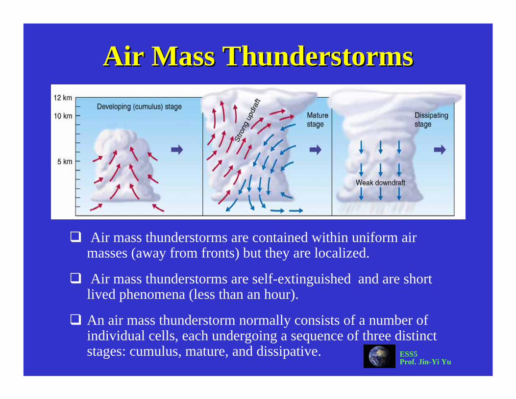
Air mass thunderstorms are contained within uniform air masses (away from fronts) but they are localized.
Air mass thunderstorms are self-extinguished and are short lived phenomena (less than an hour).
An air mass thunderstorm normally consists of a number of individual cells, each undergoing a sequence of three distinct stages: cumulus, mature, and dissipative.

ESS5Prof. Jin-Yi Yu
Cumulus (Developing) StageCumulus (Developing) StageThis begins with unstable air rises often as some surfaces undergo more rapid heating than others.
Only updrafts are present as air rises and adiabatically cools.
At first, the cumulus clouds grow upward only for a short distance, then they dissipate (because of re-evaporation)
Eventually, enough water vapor will be present to sustain vertical cloud development which occurs between 5-20 m/sec (10-45 mph)
When precipitation begins to fall, the storm enters its next stage.
ESS5Prof. Jin-Yi Yu
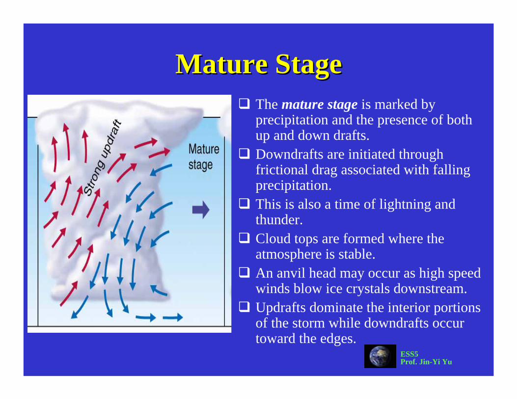
Mature StageMature StageThe mature stage is marked by precipitation and the presence of both up and down drafts.Downdrafts are initiated through frictional drag associated with falling precipitation.This is also a time of lightning and thunder.Cloud tops are formed where the atmosphere is stable.An anvil head may occur as high speed winds blow ice crystals downstream.Updrafts dominate the interior portions of the storm while downdrafts occur toward the edges.
ESS5Prof. Jin-Yi Yu
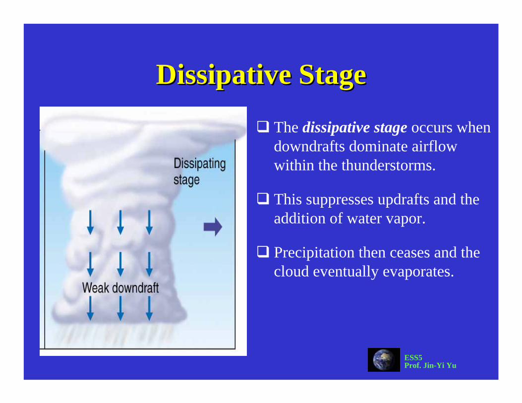
Dissipative StageDissipative Stage
The dissipative stage occurs when downdrafts dominate airflow within the thunderstorms.
This suppresses updrafts and the addition of water vapor.
Precipitation then ceases and the cloud eventually evaporates.

ESS5Prof. Jin-Yi Yu
Severe ThunderstormsSevere ThunderstormsOccur when winds exceed 93 km/hr (58 mph), have large hailstones (1.9 cm; 0.75 in) or produce tornadoes.
These systems differ from air mass thunderstorms in that the up and downdrafts support each other to intensify the storm.
Particular atmospheric conditions must persist across the mesoscale(10-1000 km) for severe thunderstorms to develop.Atmospheric conditions
supporting severe thunderstorms include wind shear, high water vapor content in lower portions of the troposphere.

ESS5Prof. Jin-Yi Yu
Mesoscale Mesoscale Convective SystemsConvective SystemsClusters of severe thunderstorms are called mesoscaleconvective systems (MCSs).
MCSs occur as squall lines, or as circular clusters called mesoscale convective complex’s (MCCs).
Individual storms develop in concert in a situation which propagates additional thunderstorms.
Many MCSs have life spans from up to 12 hrs to several days.
Severe thunderstorms may also form from individual supercells which contain only one updraft (supercells may also be a part of an MCS).

ESS5Prof. Jin-Yi Yu
Mesoscale Mesoscale Convective ComplexConvective ComplexMCCs account for the greatest amount of severe weather in the U.S. and Canada.
Circular clusters of thunderstorms which are self propagating in that individual cells create downdrafts which interact to form new cells.
Colder, denser downdrafts spread across the surface and help force warm, moist surface air aloft.
This outflow boundary initiates a new cell.
The entire system typically propagates eastward.

ESS5Prof. Jin-Yi Yu
Mesoscale Mesoscale Convective ComplexConvective Complex

ESS5Prof. Jin-Yi Yu
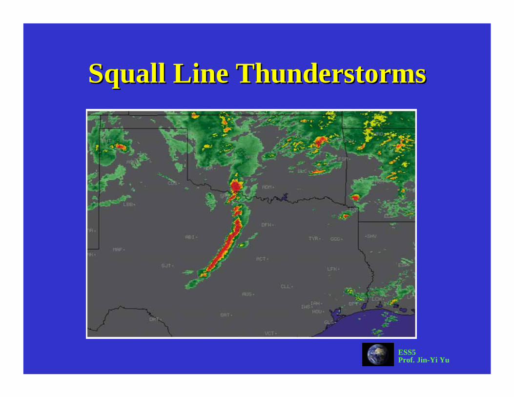
Squall Line ThunderstormsSquall Line ThunderstormsBands may be as long as 500 km (300 mi) usually about 300-500 km (180-300 mi) in advance of cold fronts.
Strong vertical wind shear is essential to the development of these prefrontal waves as it ensures that updrafts will be positioned ahead of the downdrafts.
This feeds moisture into the system which is also aided by gust front propagation ahead of the situation.
ESS5Prof. Jin-Yi Yu
Squall Line ThunderstormsSquall Line Thunderstorms
ESS5Prof. Jin-Yi Yu
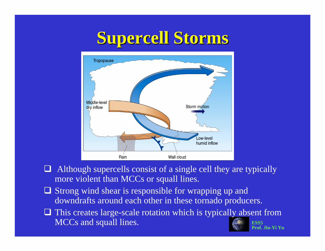
Supercell Supercell StormsStorms
Although supercells consist of a single cell they are typically more violent than MCCs or squall lines.Strong wind shear is responsible for wrapping up and downdrafts around each other in these tornado producers.This creates large-scale rotation which is typically absent from MCCs and squall lines.

ESS5Prof. Jin-Yi Yu
Downbursts and Downbursts and MicroburstsMicrobursts
Strong downdrafts can create deadly gusts of winds, called downbursts.Downbursts can be mistakenly considered
as tornadoes.When downbursts have diameters of less
than 4 km, they are called microbursts.Microbursts are dangerous to airplanes.
ESS5Prof. Jin-Yi Yu
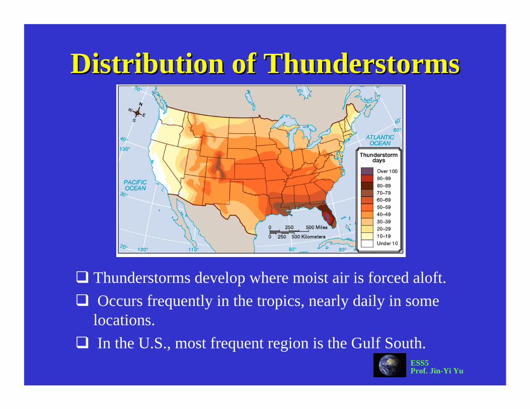
Distribution of ThunderstormsDistribution of Thunderstorms
Thunderstorms develop where moist air is forced aloft.Occurs frequently in the tropics, nearly daily in some locations.In the U.S., most frequent region is the Gulf South.

ESS5Prof. Jin-Yi Yu
TornadoesTornadoes
Tornadoes are zones of extremely rapid, rotating winds beneath the base of cumulonimbus clouds.Strong counterclockwise (in N.H.) winds originate in relation
to large pressure gradients over small spatial scales.Pressure differences may be as much as 100 mb over a few
tenths of km.

ESS5Prof. Jin-Yi Yu
Tornado CharacteristicsTornado CharacteristicsTypically have diameters of about 100 yards but may be much larger.
Usually a short lived phenomena lasting only a few minutes, but some have lasted for hours.
Movement is generally about 50km/hr (30 mph) over an areas about 3-4 km (2-2.5 mi) long.
Winds may be as low as 65 km/hr (40 mph) or as high as 450 km/hr (280 mph).
Come in wide range of shape and size.

ESS5Prof. Jin-Yi Yu
Tornado FormationTornado Formation
Common to frontal boundaries, squall lines, MCCs, supercells and tropical cyclones.
Most violent tornadoes are associated with supercells

ESS5Prof. Jin-Yi Yu
Supercell Supercell Tornado DevelopmentTornado Development
Vertical wind shear creates a horizontal vortex.
The vortex is tilted vertically by strong updrafts and forms a mesocyclone.
The vortex stretches downward when the mesocyclone intensified.
A wall cloud id formed under the cloud base, which then develops into a tornadoes.
Only about 1/2 of all mesocyclonesactually spawn a tornado
ESS5Prof. Jin-Yi Yu

ESS5Prof. Jin-Yi Yu
NonsupercellNonsupercell Tornado Development ITornado Development I
thunderstorm
thunderstorm
tornadoes

ESS5Prof. Jin-Yi Yu
NonsupercellNonsupercell Tornado Development IITornado Development II

ESS5Prof. Jin-Yi Yu
Location and Timing of TornadoesLocation and Timing of Tornadoes
The U.S. is the world leader in tornado production.This results from the regular interaction between the air mass from the Gulf of Mexico and the air mass from the polar continent.The absence of topographic barriers ensures regular mixing and the production of violent storm systems.

ESS5Prof. Jin-Yi Yu
Tornado AlleyTornado Alley
The vast majority occur in Tornado Alley, a region from the southern Plains to the lower Great Lakes.Texas has the highest tornado frequency of any state.

ESS5Prof. Jin-Yi Yu
Tornado SeasonTornado Season
May is the month of highest frequency while June is a close second.
Many states show tornado peaks during different months, however, late spring is the time of greatest overall activity.
It is the season when air mass contrasts are especially strong.

ESS5Prof. Jin-Yi Yu
Tornado DamageTornado DamageWinds, not pressure change, cause the greatest amount of damage.
Flying debris causes the greatest amount of injuries.
Some tornadoes have multiple suction vortices which may account for rather selective damage patterns.
Tornadoes are classified using the Fujita scale which ranks tornadoes based on damage.

ESS5Prof. Jin-Yi Yu
Fujita Intensity ScaleFujita Intensity Scale
weakweak
strongstrong
violentviolent