Chapter 1: South Bents to Shields Ferry - gov.uk · Chapter 1: South Bents to Shields Ferry England...
14
England Coast Path | South Bents to Amble | Natural England’s Proposals www.gov.uk/natural-england Chapter 1: South Bents to Shields Ferry England Coast Path: South Bents to Amble - Natural England’s Proposals Part 1.1: Introduction Start Point: South Bents (grid reference: NZ 4074 6122) End Point: Shields Ferry (grid reference: NZ 3591 6709) Relevant Maps: 1a to 1h Understanding the proposals and accompanying maps: The Trail: 1.1.1 Generally follows existing walked routes, including public rights of way, along most of this length. 1.1.2 Mainly follows the coastline quite closely and maintains good views of the sea. 1.1.3 Along section SBA-1-S005 the proposed route follows an existing public footpath. At ‘Souter Point’ the definitive line is still shown on the map, but due to erosion this is no longer a viable route. The proposed route follows the walked line, which is being managed as the public footpath. 1.1.4 From sections SBA-1-S025 to SBA-1-S028 an inland diversion, which offers good views of the coast and River Tyne, is necessary to take the trail past an area of light industry, which offers no coastal views. 1.1.5 This part of the coast includes the following sites, designated for nature conservation or heritage preservation (See map C of the Overview): Durham Coast Special Area of Conservation (SAC) Northumbria Coast Ramsar site Durham Coast Site of Special Scientific Interest (SSSI) for its geological /wildlife interest We have assessed the potential impacts of access along the proposed route (and over the associated spreading room described below) on the features for which the affected land is designated and on any which are protected in their own right.
Transcript of Chapter 1: South Bents to Shields Ferry - gov.uk · Chapter 1: South Bents to Shields Ferry England...
England Coast Path | South Bents to Amble | Natural England’s Proposals
www.gov.uk/natural-england
Chapter 1:
South Bents to Shields Ferry England Coast Path: South Bents to Amble - Natural England’s Proposals
Part 1.1: Introduction
Start Point: South Bents (grid reference: NZ 4074 6122)
End Point: Shields Ferry (grid reference: NZ 3591 6709)
Relevant Maps: 1a to 1h
Understanding the proposals and accompanying maps:
The Trail:
1.1.1 Generally follows existing walked routes, including public rights of way, along most of this length.
1.1.2 Mainly follows the coastline quite closely and maintains good views of the sea.
1.1.3 Along section SBA-1-S005 the proposed route follows an existing public footpath. At ‘Souter Point’ the definitive line is still shown on the map, but due to erosion this is no longer a viable route. The proposed route follows the walked line, which is being managed as the public footpath.
1.1.4 From sections SBA-1-S025 to SBA-1-S028 an inland diversion, which offers good views of the coast and River Tyne, is necessary to take the trail past an area of light industry, which offers no coastal views.
1.1.5 This part of the coast includes the following sites, designated for nature conservation or heritage preservation (See map C of the Overview):
Durham Coast Special Area of Conservation (SAC)
Northumbria Coast Ramsar site
Durham Coast Site of Special Scientific Interest (SSSI) for its geological /wildlife interest
We have assessed the potential impacts of access along the proposed route (and over the associated spreading room described below) on the features for which the affected land is designated and on any which are protected in their own right.
England Coast Path | South Bents to Amble | Natural England’s Proposals
1.1.6 The levels and patterns of public access along this length of coast would be unlikely to change significantly as a result of our proposals and we have therefore concluded that our proposals would not be likely to have any significant impact on these features.
In relation to those nature conservation sites listed above, refer to our published Access and Sensitive Features Appraisal for more information.
See part 5b of the Overview - ‘Natural environment’ - for more information.
Accessibility:
1.1.7 Generally, there are few artificial barriers to accessibility on the proposed route, which makes use of existing surface paths wherever these meet the criteria in the Coastal Access Scheme.
However, there are places where it may not be entirely suitable for people with reduced mobility because:
The trail would follow an uneven grass or bare soil path along the cliff top;
There are steps in places where it would be necessary to ascend/descend between sections SBA-1-S027 to SBA-1-S030.
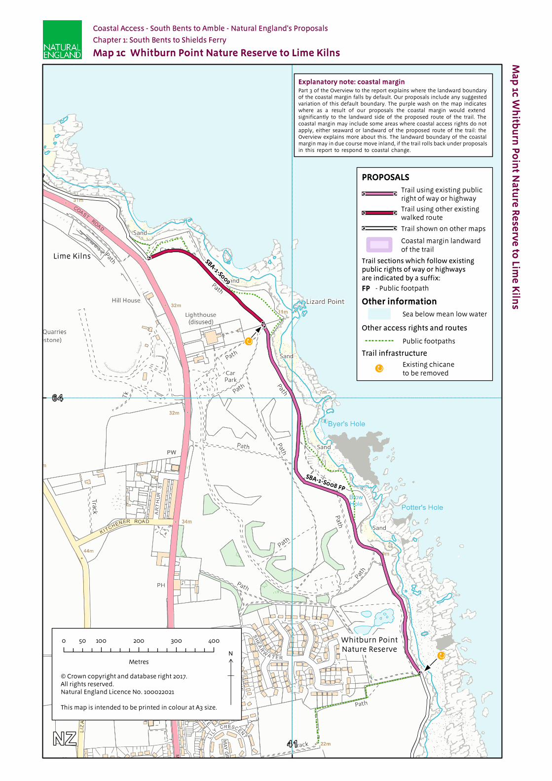
1.1.8 At the intersections of SBA-1-S007 FP, SBA-1-S008 FP and SBA-1-S009 the existing chicanes will be removed, as they are rusty and in poor condition. We envisage this work happening before the new access rights come into force as part of the physical establishment work described in part 6 of the Overview.
See part 5a of the Overview - ‘Recreational issues’ - for more information.
Where we have proposed exercising our discretion:
The discretions referred to below are explained in more detail in part 10 of the Overview.
1.1.9 Estuary: This report proposes that the trail should include a route around the estuary of the River Tyne, extending upstream from the open coast as far as the Shields ferry crossing. See part 10a of the Overview. The trail covered by this chapter includes part of this estuary route.
1.1.10 Landward boundary of the coastal margin: We have used our discretion on some sections of the route to map the landward extent of the coastal margin to an adjacent physical boundary such as a fence line, pavement or track to make the extent of the new access rights clearer. See Table 1.2.1 below.
See also part 3 of the Overview - ‘Understanding the proposals and accompanying maps’, for an explanation of the default extent of the coastal margin and how we may use our discretion to adjust the margin, either to add land or to provide clarity. See also Annex C of the Overview - ‘Excepted land categories’.
1.1.11 Restrictions and/or exclusions: Access rights to the spreading room would be subject to the national restrictions on coastal access rights listed in Annex D of the Overview. These restrictions would not apply to public rights of way.
England Coast Path | South Bents to Amble | Natural England’s Proposals
See part 9 of the Overview - ‘Restrictions and exclusions’ - for details.
1.1.12 Establishment: Some physical establishment of the trail would be necessary, in accordance with the general approach described in part 6 the Overview.
At the intersections of SBA-1-S007 FP, SBA-1-S008 FP and SBA-1-S009 the existing chicanes will be removed, as they are rusty and in poor condition.
1.1.13 Ongoing management: Ongoing management and maintenance would be necessary in accordance with the general approach described in part 7 of the Overview.
See parts 6 - ‘Physical establishment of the trail’ and 7 - ‘Maintenance of the trail’ of the Overview for more information.
Future Change:
1.1.14 Part of the route of the trail on this length of coast would be able to change, without further approval, from the Secretary of State in response to coastal erosion or other geomorphological processes, or encroachment by the sea. This would happen in accordance with the criteria and procedures for ‘roll back’ set out in part 8 of the Overview. See table 1.2.1 below for details of the sections likely to be affected in the foreseeable future.
1.1.15 At the time of preparing the report, we do not foresee any other need for future changes to the access provisions proposed for the length of coast described in this chapter.
See parts 5e - ‘Coastal processes’ and 8 - ‘Future changes’ of the Overview for more information.

England Coast Path | South Bents to Amble | Natural England’s Proposals
Part 1.2: Commentary on Maps
See Part 3 of Overview for guidance on reading and understanding the tables below
1.2.1 Section Details – Maps 1a to 1h: South Bents to Shields Ferry
Notes on table:
Column 2 – an asterisk (*) against the route section number means see also table 1.2.2: Other options considered.
Column 5 – ‘Yes – normal’ means roll-back approach is likely to follow the current feature (e.g. cliff edge/beach) for the foreseeable future.
1 2 3 4 5 6a 6b 7Map(s) Route section
number(s) Current status of this section
Current surface of this section
Roll-back proposed? (See Part 8 of Overview)
Landward boundary of margin (See maps)
Reason for landward boundary discretion
Proposed exclusions or restrictions(see Part 9 of Overview)
1a SBA-1-S001 FW Public footway (pavement)
Tarmac Yes: Normal Pavement edge
Clarity and cohesion
None
SBA-1-S002 FW Public footway (pavement)
Tarmac Yes: Normal Pavement edge
Clarity and cohesion
None
SBA-1-S003 FP Public footpath
Gravel Yes: Normal Landward edge of trail
Not used None
1b SBA-1-S004 FP Public footpath
Gravel Yes: Normal Fence line Clarity and cohesion
None
SBA-1-S005 Other existing walked route
Gravel Yes: Normal Fence line Clarity and cohesion
None
SBA-1-S006 FP Public footpath
Gravel Yes: Normal Fence line Clarity and cohesion
None
SBA-1-S007 FP Public footpath
Gravel Yes: Normal Fence line Clarity and cohesion
None
1c SBA-1-S008 FP Public footpath
Gravel Yes: Normal Various Clarity and cohesion
None
SBA-1-S009 Other existing walked route
Grass Yes: Normal Landward edge of trail
Not used None
1d SBA-1-S010 Other existing walked route
Grass Yes: Normal Landward edge of trail
Not used None
SBA-1-S011 Other existing walked route
Grass Yes: Normal Landward edge of trail
Not used None
SBA-1-S012 Other existing walked route
Grass Yes: Normal Landward edge of trail
Not used None
SBA-1-S013 FP Public footpath
Grass Yes: Normal Landward edge of trail
Not used None
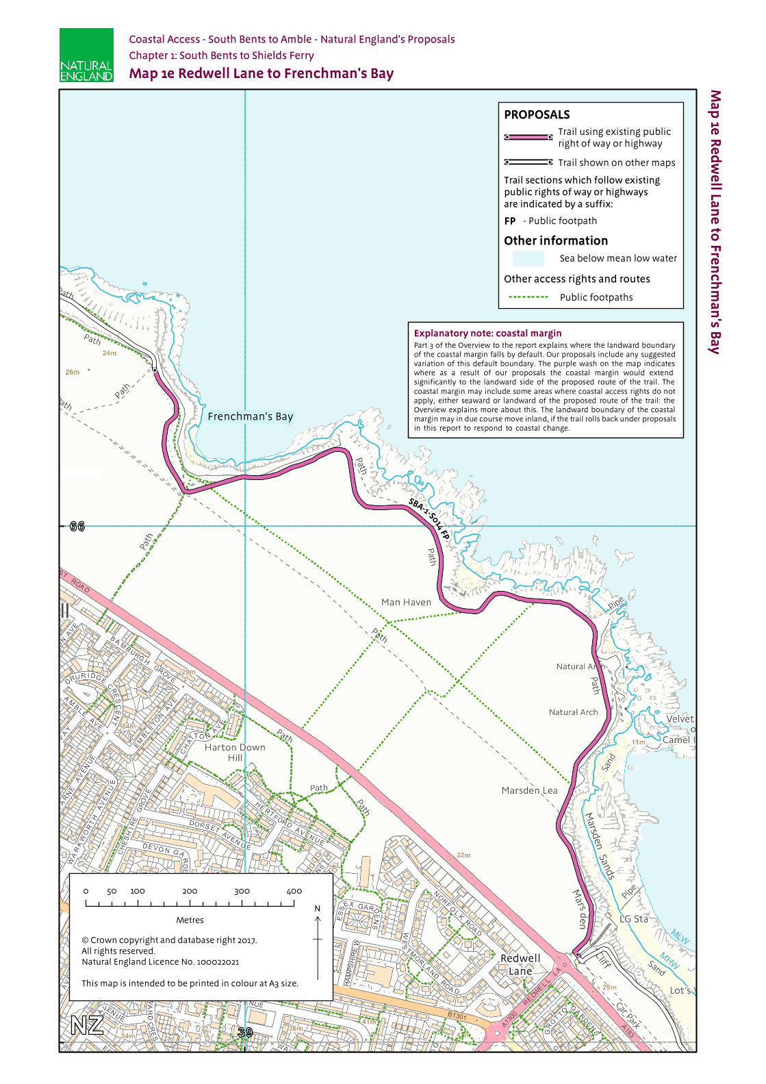
1e SBA-1-S014 FP Public footpath
Gravel Yes: Normal Landward edge of trail
Not used None
1f SBA-1-S015 FP Public footpath
Tarmac Yes: Normal Landward edge of trail
Not used None
SBA-1-S016 FP Public footpath
Gravel Yes: Normal Landward edge of trail
Not used None
SBA-1-S017 Other existing walked route
Tarmac Yes: Normal Landward edge of track
Clarity and cohesion
None
1g SBA-1-S018 Other existing walked route
Tarmac No Pavement edge
Clarity and cohesion
None
SBA-1-S019 Other existing walked route
Block paving No Promenade edge
Clarity and cohesion
None
England Coast Path | South Bents to Amble | Natural England’s Proposals
1 2 3 4 5 6a 6b 7Map(s) Route section
number(s) Current status of this section
Current surface of this section
Roll-back proposed? (See Part 8 of Overview)
Landward boundary of margin (See maps)
Reason for landward boundary discretion
Proposed exclusions or restrictions(see Part 9 of Overview)
1g SBA-1-S020 Other existing walked route
Block paving No Promenade edge
Clarity and cohesion
None
SBA-1-S021 Other existing walked route
Concrete No Pavement edge
Clarity and cohesion
None
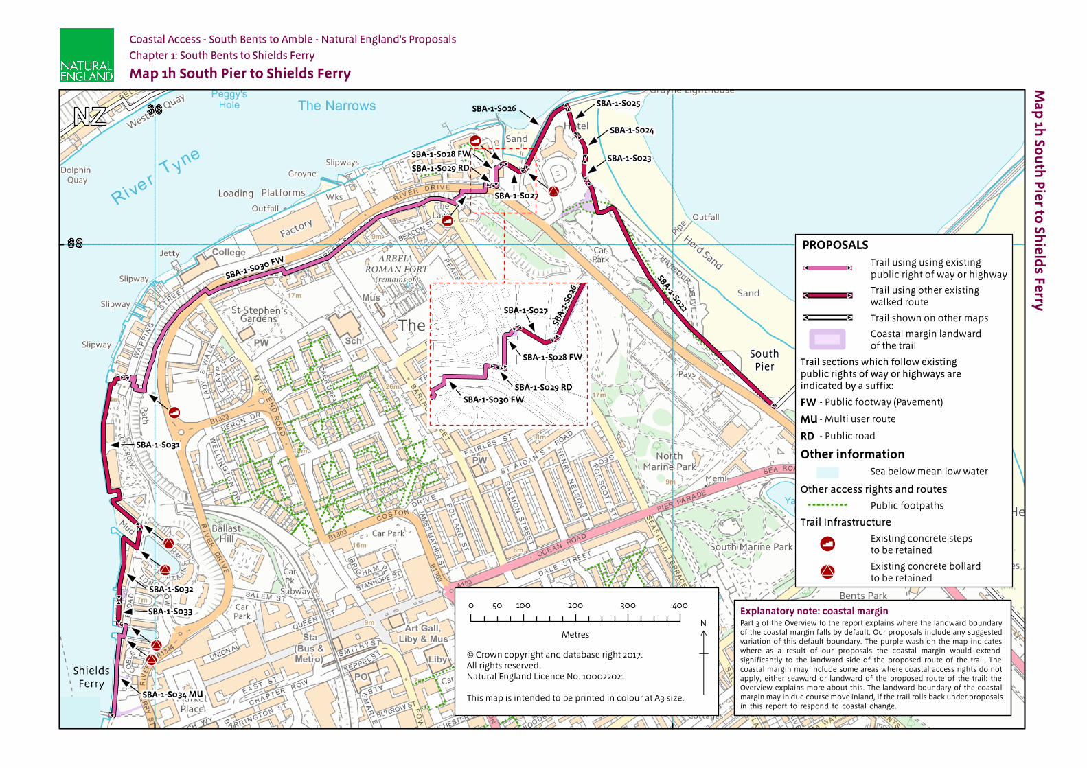
1h SBA-1-S022 Other existing walked route
Block paving No Promenade edge
Clarity and cohesion
None
SBA-1-S023 Other existing walked route
Block paving No Pavement edge
Clarity and cohesion
None
SBA-1-S024 Other existing walked route
Block paving No Pavement edge
Clarity and cohesion
None
SBA-1-S025 Other existing walked route
Block paving No Wall Clarity and cohesion
None
SBA-1-S026 Other existing walked route
Gravel No Wall Clarity and cohesion
None
SBA-1-S027 Other existing walked route
Concrete No Landward edge of trail
Not used None
SBA-1-S028 FW Public footway (pavement)
Tarmac No Pavement edge
Clarity and cohesion
None
SBA-1-S029 RD Public highway
Tarmac No Landward edge of trail
Not used None
SBA-1-S030 FW* Public footway (pavement)
Tarmac No Pavement edge
Clarity and cohesion
None
SBA-1-S031 Other existing walked route
Block paving No Pavement edge
Clarity and cohesion
None
SBA-1-S032 Other existing walked route
Block paving No Pavement edge
Clarity and cohesion
None
SBA-1-S033 Other existing walked route
Boardwalk or raised walkway
No Landward edge of trail
Not used None
SBA-1-S034 MU Multi-use route
Block paving No Pavement edge
Clarity and cohesion
None
1.2.2 Other options considered: Map 1h: South Pier to Shields Ferry
Map(s) Section number(s)
Option(s) considered Reasons for not proposing this option as the route
1h SBA-1-S030 FW
We considered aligning the trail along River Drive and Wapping Street.
We opted for the proposed route because:■ The proposed route is more pleasant and affords
good views of the River Tyne and Tynemouth.■ Our proposal met with approval from the Local
Access Authority. ■ Under our proposals, the public footpath would
remain available for people to use as part of the spreading room, but would not form part of the designated trail.

England Coast Path | South Bents to Amble | Natural England’s Proposals
Part 1.3: Chapter 1 - Formal Proposals Below are our formal proposals to the Secretary of State for the length of coast shown on maps 1a to 1h.
They should be read in conjunction with the relevant maps.
The commentary above explains the practical effect of these proposals.
Formal Proposals – South Bents to Shields Ferry
Discretion to include an estuary
1.3.1 Natural England proposes to exercise its functions as if the sea included the estuarial waters of the River Tyne as far as the Shields Ferry, as indicated by the extent of the trail shown on map 1h.
Proposed route of the trail
1.3.2 In relation to route sections SBA-1-S001 FW to SBA-1-S017, the route is to be at the centre of the line shown on maps 1a to 1f as the proposed route of the trail.
1.3.3 If at any time any part of a route section listed in the previous paragraph needs, in Natural England’s view, to change as a result of coastal erosion or other geomorphological processes or encroachment by the sea, in order for the overall route to remain viable, the new route for the part in question will be determined by Natural England without further reference to the Secretary of State. This will be done in accordance with the criteria and procedures described under the title ‘Roll-back’ in part 8 of the Overview and section 4.10 of the Coastal Access Scheme. If this happens, the new route will become the approved route for that section for the purposes of the Order which determines where coastal access rights apply.
Landward boundary of coastal margin
1.3.4 Adjacent to route sections; SBA-1-S004 FP and SBA-1-S007 FP, the landward boundary of the coastal margin is to coincide with the existing boundary fence which, at the time of writing this report, is landward of the trail on map 1b.
Adjacent to route sections; SBA-1-S025 and SBA-1-S026 the landward boundary of the coastal margin is to coincide with the existing boundary wall which, at the time of writing this report, is landward of the trail on map 1h.
1.3.5 Adjacent to route sections: SBA-1-S001 and SBA-1-S002, SBA-1-S018, SBA-1-S021, SBA-1-S023, SBA-1-S024, SBA-1-S028 FW, SBA-1-S030 FW, SBA-1-S031, SBA-1-S032 and SBA-1-S034 MU the landward boundary of the coastal margin is to coincide with landward edge of the pavement shown as the trail on maps 1a, 1g and 1h.
Adjacent to route sections: SBA-1-S019 and SBA-1-S020, SBA-1-S022 the landward boundary of the coastal margin is to coincide with landward edge of the promenade shown as the trail on maps 1g and 1h.
Adjacent to route sections: SBA-1-S017 the landward boundary of the coastal margin is to coincide with landward edge of the track shown as the trail on map 1f.
Adjacent to route sections: SBA-1-S008 FP landward boundary of the coastal margin is to coincide with landward edge of the wall and track (various) shown as the trail on map 1c.
Local restrictions and exclusions
1.3.6 At the time of writing this report, there are no proposals for local restrictions or exclusions in relation to this length of coast.
Alternative Routes
1.3.7 There are no proposals for alternative routes in relation to this length of coast.

SBA-1-S001 FW
SBA-1-S002 FW
SBA-1-S
003
FP
Ma
p 1a
So
uth
Be
nts to
Ra
ck
ly W
ay
Go
it
Explanatory note: coastal marginPart 3 of the Overview to the report explains where the landward boundary of the coastal margin falls by default. Our proposals include any suggested variation of this default boundary. The purple wash on the map indicates where as a result of our proposals the coastal margin would extend significantly to the landward side of the proposed route of the trail. The coastal margin may include some areas where coastal access rights do not apply, either seaward or landward of the proposed route of the trail: the Overview explains more about this. The landward boundary of the coastal margin may in due course move inland, if the trail rolls back under proposals in this report to respond to coastal change.
Map 1a South Bents to Rackly Way Goit
Coastal Access - South Bents to Amble - Natural England's Proposals
Chapter 1: South Bents to Shields Ferry
South Bents
RacklyWay Goit
Trail sections which follow existingpublic rights of way or highwaysare indicated by a suffix:
- Public footpathFP
- Public footway (Pavement)FW
Other access rights and routes
Public footpaths
PROPOSALSTrail using existing publicright of way or highway
Trail shown on other maps
North Gare to South Bentsapproved route
Trail infrastructure
Existing kissing gateto be retained
Other information
Sea below mean low water
© Crown copyright and database right 2017. All rights reserved.Natural England Licence No. 100022021
This map is intended to be printed in colour at A3 size.
N0 100 200 300 40050
Metres

SBA-1
-S0
04 FP
SBA-1-S005
SBA
-1-S
00
7 FP
SBA
-1-S00
6 FP
Ma
p 1b
Ra
ck
ly W
ay
Go
it to W
hitb
urn
Po
int N
atu
re R
ese
rve
Explanatory note: coastal marginPart 3 of the Overview to the report explains where the landward boundary of the coastal margin falls by default. Our proposals include any suggested variation of this default boundary. The purple wash on the map indicates where as a result of our proposals the coastal margin would extend significantly to the landward side of the proposed route of the trail. The coastal margin may include some areas where coastal access rights do not apply, either seaward or landward of the proposed route of the trail: the Overview explains more about this. The landward boundary of the coastal margin may in due course move inland, if the trail rolls back under proposals in this report to respond to coastal change.
Map 1b Rackly Way Goit to Whitburn Point Nature Reserve
Coastal Access - South Bents to Amble - Natural England's Proposals
Chapter 1: South Bents to Shields Ferry
Whitburn PointNature Reserve
RacklyWay Goit
Trail sections which follow existingpublic rights of way or highwaysare indicated by a suffix:
- Public footpathFP
Other information
PROPOSALS
Other access rights and routes
© Crown copyright and database right 2017. All rights reserved.Natural England Licence No. 100022021
This map is intended to be printed in colour at A3 size.
N0 100 200 300 40050
Metres
Trail using other existingwalked route
Trail using existing publicright of way or highway
Trail shown on other maps
Coastal margin landwardof the trail
Sea below mean low water
Public footpaths
SBA-1-008
SBA-1-S009
SBA-1-S008 FP
Ma
p 1c
Wh
itbu
rn P
oin
t Na
ture
Re
serv
e to
Lime
Kiln
s
Explanatory note: coastal marginPart 3 of the Overview to the report explains where the landward boundary of the coastal margin falls by default. Our proposals include any suggested variation of this default boundary. The purple wash on the map indicates where as a result of our proposals the coastal margin would extend significantly to the landward side of the proposed route of the trail. The coastal margin may include some areas where coastal access rights do not apply, either seaward or landward of the proposed route of the trail: the Overview explains more about this. The landward boundary of the coastal margin may in due course move inland, if the trail rolls back under proposals in this report to respond to coastal change.
Map 1c Whitburn Point Nature Reserve to Lime Kilns
Coastal Access - South Bents to Amble - Natural England's Proposals
Chapter 1: South Bents to Shields Ferry
Lime Kilns
Whitburn PointNature Reserve
Trail sections which follow existingpublic rights of way or highwaysare indicated by a suffix:
- Public footpathFP
Other access rights and routes
Trail infrastructure
Public footpaths
Other information
Sea below mean low water
PROPOSALS
Trail using existing publicright of way or highway
Trail using other existingwalked route
Trail shown on other maps
Coastal margin landwardof the trail
© Crown copyright and database right 2017. All rights reserved.Natural England Licence No. 100022021
This map is intended to be printed in colour at A3 size.
N0 100 200 300 40050
Metres
Existing chicaneto be removed

SBA-1-S013
FP
SBA-1-S011SBA-1-S012
SBA-1-S010
Ma
p 1d
Lime
Kiln
s to R
ed
we
ll Lan
e
Explanatory note: coastal marginPart 3 of the Overview to the report explains where the landward boundary of the coastal margin falls by default. Our proposals include any suggested variation of this default boundary. The purple wash on the map indicates where as a result of our proposals the coastal margin would extend significantly to the landward side of the proposed route of the trail. The coastal margin may include some areas where coastal access rights do not apply, either seaward or landward of the proposed route of the trail: the Overview explains more about this. The landward boundary of the coastal margin may in due course move inland, if the trail rolls back under proposals in this report to respond to coastal change.
Map 1d Lime Kilns to Redwell Lane
Coastal Access - South Bents to Amble - Natural England's Proposals
Chapter 1: South Bents to Shields Ferry
RedwellLane
Lime Kilns
SBA-1-S0
13 FP
SBA-1-S011
SBA-1
-S012
Other access rights and routes
Other information
PROPOSALS
Trail infrastructure
© Crown copyright and database right 2017. All rights reserved.Natural England Licence No. 100022021
This map is intended to be printed in colour at A3 size.
N0 100 200 300 40050
Metres
Trail using existing publicright of way or highway
Trail using other existingwalked route
Trail shown on other maps
Sea below mean low water
Public footpaths
Trail sections which follow existingpublic rights of way or highwaysare indicated by a suffix:
- Public footpathFP
Existing bollard to be retained
Public bridleways
SBA-1-S014FP
Ma
p 1e
Re
dw
ell La
ne
to F
ren
ch
ma
n's B
ay
Explanatory note: coastal marginPart 3 of the Overview to the report explains where the landward boundary of the coastal margin falls by default. Our proposals include any suggested variation of this default boundary. The purple wash on the map indicates where as a result of our proposals the coastal margin would extend significantly to the landward side of the proposed route of the trail. The coastal margin may include some areas where coastal access rights do not apply, either seaward or landward of the proposed route of the trail: the Overview explains more about this. The landward boundary of the coastal margin may in due course move inland, if the trail rolls back under proposals in this report to respond to coastal change.
Map 1e Redwell Lane to Frenchman's Bay
Coastal Access - South Bents to Amble - Natural England's Proposals
Chapter 1: South Bents to Shields Ferry
Frenchman's Bay
RedwellLane
Trail sections which follow existingpublic rights of way or highwaysare indicated by a suffix:
- Public footpathFP
Other access rights and routes
PROPOSALS
Other information
© Crown copyright and database right 2017. All rights reserved.Natural England Licence No. 100022021
This map is intended to be printed in colour at A3 size.
N0 100 200 300 40050
Metres
Trail shown on other maps
Trail using existing publicright of way or highway
Sea below mean low water
Public footpaths
SBA-1-S015 FP
SBA-1-S01 6 FP
SBA-1-S017
Ma
p 1f F
ren
ch
ma
n's B
ay
to G
yp
sies G
ree
n S
po
rts Gro
un
d
Explanatory note: coastal marginPart 3 of the Overview to the report explains where the landward boundary of the coastal margin falls by default. Our proposals include any suggested variation of this default boundary. The purple wash on the map indicates where as a result of our proposals the coastal margin would extend significantly to the landward side of the proposed route of the trail. The coastal margin may include some areas where coastal access rights do not apply, either seaward or landward of the proposed route of the trail: the Overview explains more about this. The landward boundary of the coastal margin may in due course move inland, if the trail rolls back under proposals in this report to respond to coastal change.
Map 1f Frenchman's Bay to Gypsies Green Sports Ground
Coastal Access - South Bents to Amble - Natural England's Proposals
Chapter 1: South Bents to Shields Ferry
Gypsies GreenSports Ground
Frenchman'sBay
Other access rights and routes
Trail sections which follow existingpublic rights of way or highwaysare indicated by a suffix:
- Public footpathFP
PROPOSALS
Other information
Public footpaths
Trail using existing publicright of way or highway
Trail shown on other maps
Trail using other existingwalked route
Sea below mean low water
© Crown copyright and database right 2017. All rights reserved.Natural England Licence No. 100022021
This map is intended to be printed in colour at A3 size.
N0 100 200 300 40050
Metres
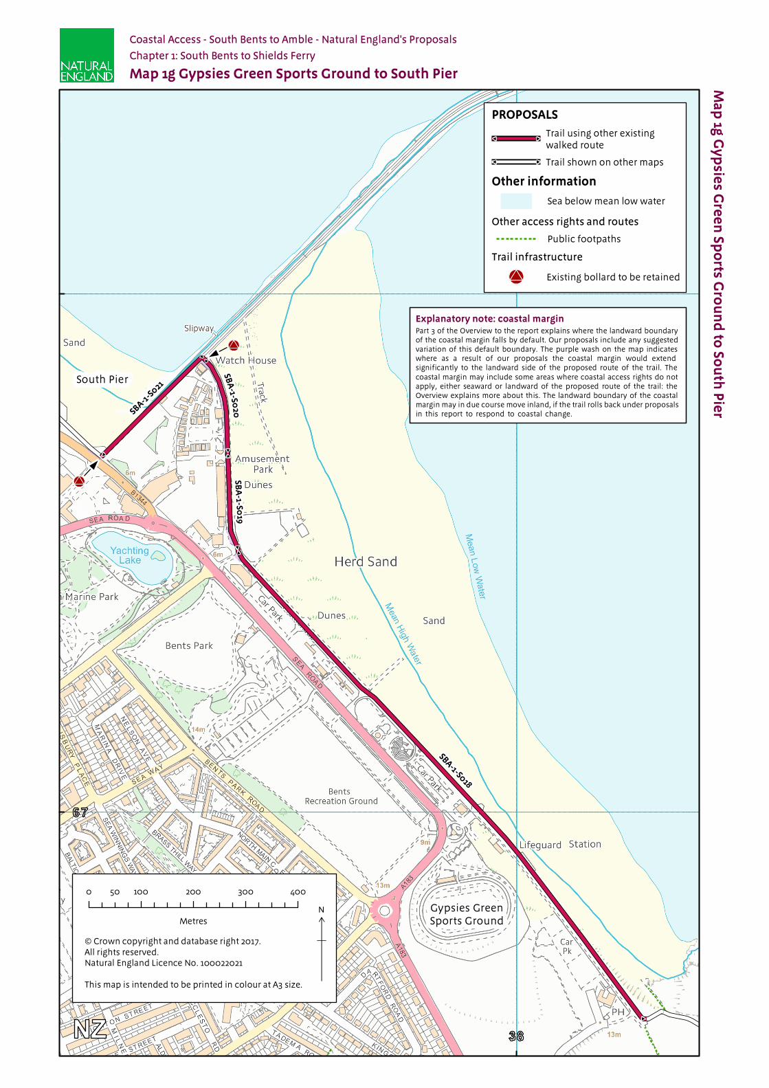
SBA
-1-S020
SBA
-1-S019
SBA-1-S
021
SBA-1-S018
Ma
p 1g
Gy
psie
s Gre
en
Sp
orts G
rou
nd
to S
ou
th P
ier
Explanatory note: coastal marginPart 3 of the Overview to the report explains where the landward boundary of the coastal margin falls by default. Our proposals include any suggested variation of this default boundary. The purple wash on the map indicates where as a result of our proposals the coastal margin would extend significantly to the landward side of the proposed route of the trail. The coastal margin may include some areas where coastal access rights do not apply, either seaward or landward of the proposed route of the trail: the Overview explains more about this. The landward boundary of the coastal margin may in due course move inland, if the trail rolls back under proposals in this report to respond to coastal change.
Map 1g Gypsies Green Sports Ground to South Pier
Coastal Access - South Bents to Amble - Natural England's Proposals
Chapter 1: South Bents to Shields Ferry
Gypsies GreenSports Ground
South Pier
PROPOSALS
Other access rights and routes
Trail infrastructure
Other information
© Crown copyright and database right 2017. All rights reserved.Natural England Licence No. 100022021
This map is intended to be printed in colour at A3 size.
N0 100 200 300 40050
Metres
Trail using other existingwalked route
Trail shown on other maps
Sea below mean low water
Public footpaths
Existing bollard to be retained
SBA-1-S024
SBA-1-S025SBA-1-S026
SBA-1-S027
SBA-1-S028 FW
SBA-1-S033
SBA-1-S034 MU
SBA-1-S031
SBA-1-S029 RDSBA-1-S023
SBA-1-S032
SBA-1-S022
SBA-1-S030 FW
Ma
p 1h
Sou
th P
ier to
Shie
lds F
erry
Explanatory note: coastal marginPart 3 of the Overview to the report explains where the landward boundary of the coastal margin falls by default. Our proposals include any suggested variation of this default boundary. The purple wash on the map indicates where as a result of our proposals the coastal margin would extend significantly to the landward side of the proposed route of the trail. The coastal margin may include some areas where coastal access rights do not apply, either seaward or landward of the proposed route of the trail: the Overview explains more about this. The landward boundary of the coastal margin may in due course move inland, if the trail rolls back under proposals in this report to respond to coastal change.
Map 1h South Pier to Shields Ferry
Coastal Access - South Bents to Amble - Natural England's Proposals
ShieldsFerry
SouthPier
Chapter 1: South Bents to Shields Ferry
SBA
-1-S
026
SBA-1-S028 FW
SBA-1-S030 FW
SBA-1-S027
SBA-1-S029 RD
Other access rights and routes
Trail Infrastructure
PROPOSALS
Other information
© Crown copyright and database right 2017. All rights reserved.Natural England Licence No. 100022021
This map is intended to be printed in colour at A3 size.
N0 100 200 300 40050
Metres
Trail using using existingpublic right of way or highway
Trail using other existingwalked route
Trail shown on other maps
Coastal margin landwardof the trail
Trail sections which follow existingpublic rights of way or highways areindicated by a suffix:
- Public footway (Pavement)FW
- Public roadRD
- Multi user routeMU
Sea below mean low water
Public footpaths
Existing concrete stepsto be retained
Existing concrete bollardto be retained