Chalmers University of Technology Welcome to the RNN ...
38
Department of Space, Earth and Environment 1 Onsala Space Observatory Chalmers University of Technology Welcome to the RNN- seminar on: New GNSS signals - opportunities for new PNT applications and improved robustness 2018-11-29
Transcript of Chalmers University of Technology Welcome to the RNN ...

Department of Space, Earth and Environment 1 Onsala Space Observatory
Chalmers University of Technology
Welcome to the RNN-
seminar on:
New GNSS signals -
opportunities for new
PNT applications and
improved robustness
2018-11-29

Department of Space, Earth and Environment 2 Onsala Space Observatory
Chalmers University of Technology
New GNSS Signals – applications & robustness
Jan Johansson
Chalmers University of Technology
Department of Space, Earth and Environment,
Onsala Space Observatory, SE-439 42 Onsala, Sweden
RNN Seminar, 29 November 2018

Department of Space, Earth and Environment 3 Onsala Space Observatory
Chalmers University of Technology3
10 navigation signals are transmitted
OS : Open Service
CS: Commercial service
PRS: Public Regulated Service
SoL: Safety of Life
Signal Modulation
Carrier
frequency
(MHz)
Data
/Pilot OS SoL CS PRS
E5a-I BPSK(10) 1176.45 Data
E5a-Q BPSK(10) 1176.45 Pilot
E5b-I BPSK(10) 1207.14 Data
E5b-Q BPSK(10) 1207.14 Pilot
E6-A BOC(10,5) 1278.75 Classified
E6-B BPSK(5) 1278.75 Data
E6-C BPSK(5) 1278.75 Pilot
L1-A BOC(15,2.5) 1575.42 Classified
L1-B BOC(1,1) 1575.42 Data
L1-C BOC(1,1) 1575.42 Pilot
Descoped
Galileo Signals
Department of Space, Earth and Environment 4 Onsala Space Observatory
Chalmers University of Technology
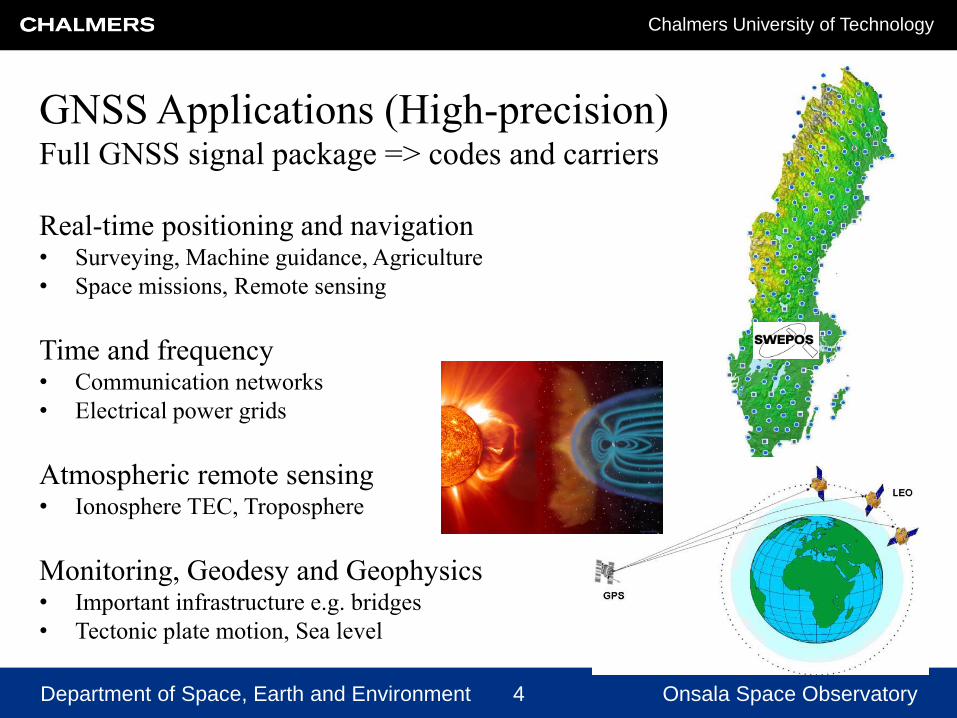
GNSS Applications (High-precision)Full GNSS signal package => codes and carriers
Real-time positioning and navigation• Surveying, Machine guidance, Agriculture
• Space missions, Remote sensing
Time and frequency• Communication networks
• Electrical power grids
Atmospheric remote sensing• Ionosphere TEC, Troposphere
Monitoring, Geodesy and Geophysics• Important infrastructure e.g. bridges
• Tectonic plate motion, Sea level

Department of Space, Earth and Environment 5 Onsala Space Observatory
Chalmers University of Technology
Satellite-based navigation
IonosphereTroposphere
Satellite orbits
& clocks
Geometry
Antennas and hardware
Signal
5
Received power (minimum):
PR = 10 -16 W = - 130 dBm = - 160 dBW
Satellite power: PT = 27 W
Antenna Gain: GT ~ 10 dBi
Transmitted power ~ 250 W
Distance > 20 000 km

Department of Space, Earth and Environment 6 Onsala Space Observatory
Chalmers University of Technology

Department of Space, Earth and Environment 7 Onsala Space Observatory
Chalmers University of Technology
Good
Bad
Multipath and Blockage
Other possible interference problems …
• Atmosphere
• Intentional interference
• Seagulls

Department of Space, Earth and Environment 8 Onsala Space Observatory
Chalmers University of Technology
A “scientific” view on GNSS development:
• Always expect new systems, satellites and signals to become available
• Trusts that all signals eventually will be possible to use => new applications
• Research on new ideas for signal generation (code and carrier)
A “conventional” GNSS user (positioning and navigation) require:
• Reliability, Robustness and achieving declared Precision
• Augmentation possibilities, Interoperability, Sensor fusion
• Often have access to other techniques for redundancy
The GNSS Time and frequency community:
• GNSS used in communication networks (e.g. Internet, Cellular phone networks)
• Permanently installed GNSS equipment in critical infrastructure for society
• Often without redundancy - Identified as a risk e.g. by authorities in Sweden
Signal requirements and robustness

Department of Space, Earth and Environment 9 Onsala Space Observatory
Chalmers University of Technology
A “scientific” view on GNSS development:
• Always expect new systems, satellites and signals to become available
• Trusts that all signals eventually will be possible to use => new applications
• Research on new ideas for signal generation (code and carrier)
A “conventional” GNSS user (positioning and navigation) require:
• Reliability, Robustness and achieving declared Precision
• Augmentation possibilities, Interoperability, Sensor fusion
• Often have access to other techniques for redundancy
The GNSS Time and frequency community:
• GNSS used in communication networks (e.g. Internet, Cellular phone networks)
• Permanently installed GNSS equipment in critical infrastructure for society
• Often without redundancy - Identified as a risk e.g. by authorities in Sweden
Signal requirements and robustness
Department of Space, Earth and Environment 10 Onsala Space Observatory
Chalmers University of Technology
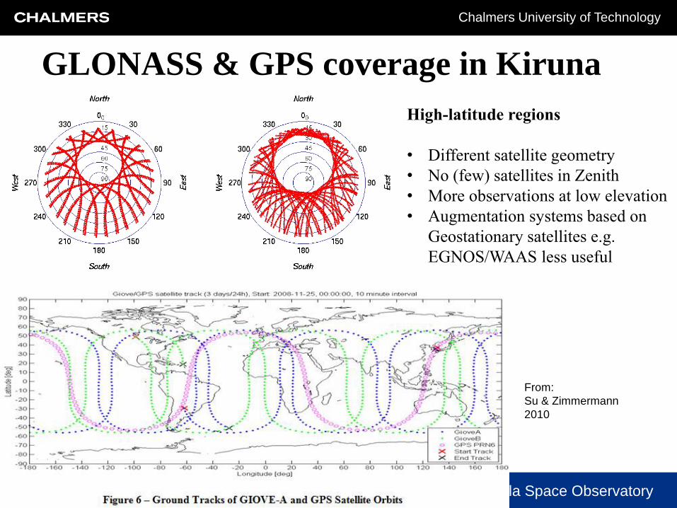
GLONASS & GPS coverage in Kiruna
High-latitude regions
• Different satellite geometry
• No (few) satellites in Zenith
• More observations at low elevation
• Augmentation systems based on
Geostationary satellites e.g.
EGNOS/WAAS less useful
From:
Su & Zimmermann
2010

Department of Space, Earth and Environment 11 Onsala Space Observatory
Chalmers University of Technology
SWEPOS – GNSS Augmentation and Monitoring
National network of 400 permanent reference stations:
• Providing real-time corrections for DGPS and RTK using
RTCM-format
• GPS/GLONASS-receivers (soon also Galileo/Beidou)
v = 4 km/s
Orbit and time errors
Ionosphere
Troposphere
20200 km
1000 km
50km
10 km
Data transmission
VRS
NMEA
RTCM

Department of Space, Earth and Environment 12 Onsala Space Observatory
Chalmers University of Technology
Satellite clocks
Department of Space, Earth and Environment 13 Onsala Space Observatory
Chalmers University of Technology
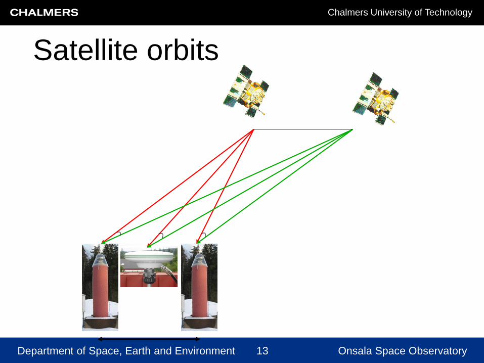
Satellite orbits

Department of Space, Earth and Environment 14 Onsala Space Observatory
Chalmers University of Technology
10 km
NRTK tropospheric error
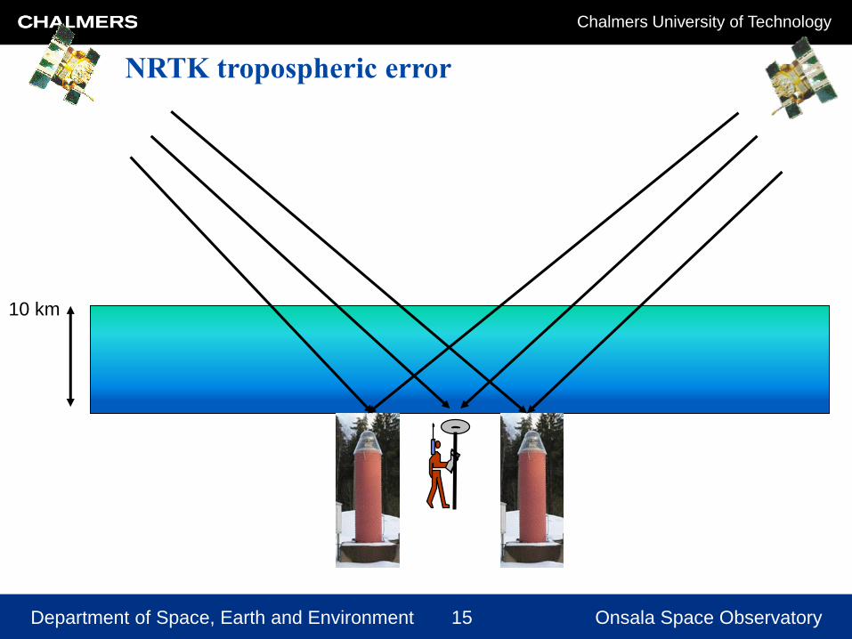
Department of Space, Earth and Environment 15 Onsala Space Observatory
Chalmers University of Technology
10 km
NRTK tropospheric error

Department of Space, Earth and Environment 16 Onsala Space Observatory
Chalmers University of Technology
NRTK tropospheric error
10 km

Department of Space, Earth and Environment 17 Onsala Space Observatory
Chalmers University of Technology
CLOSE-RTK 2
Ionosphere and the Solar cycle
Department of Space, Earth and Environment 18 Onsala Space Observatory
Chalmers University of Technology
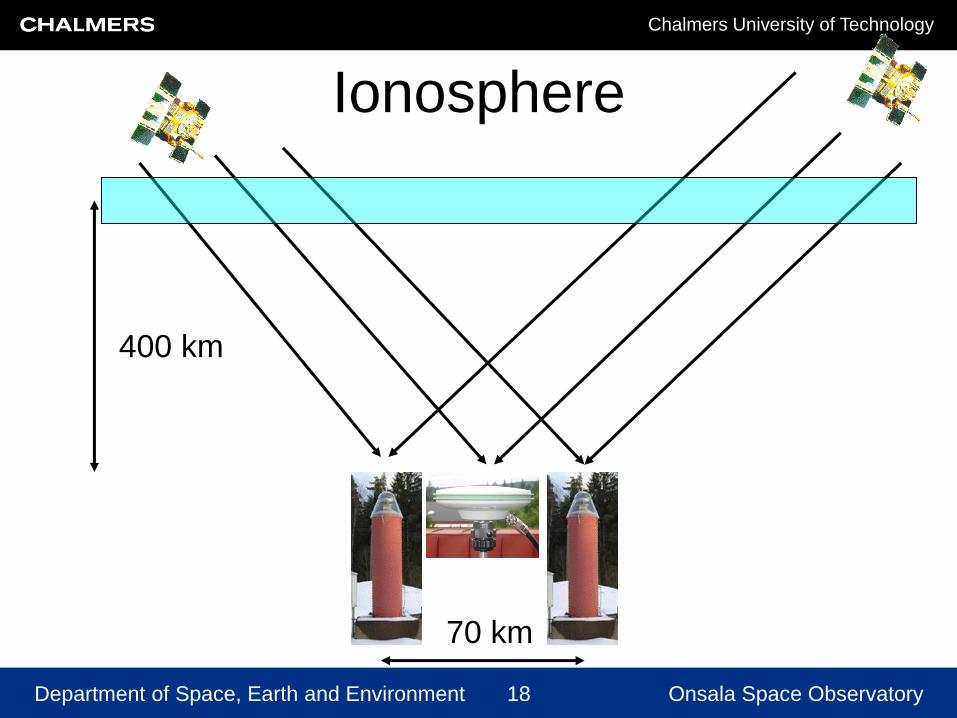
70 km
400 km
Ionosphere
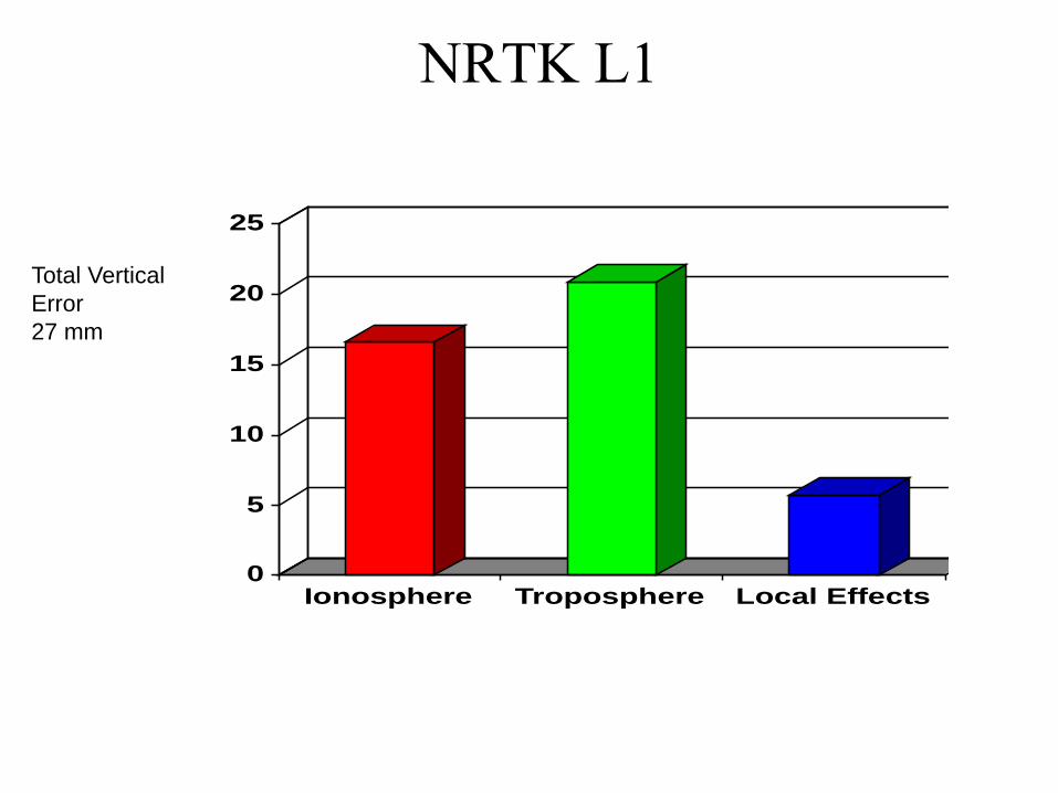
NRTK L1
0
5
10
15
20
25
Ionosphere Troposphere Local Effects
Ionosphere
Troposphere
Local Effects
Total Vertical
Error
27 mm

NRTK L3(L1+L2)
0
5
10
15
20
25
Ionosphere Troposphere Local Effects
Ionosphere
Troposphere
Local Effects
Total Vertical
Error
28 mm
L3=2.546*L1 – 1.546*L2

NRTK L1+L2+L5
0
5
10
15
20
25
Ionosphere Troposphere Local Effects
Ionosphere
Troposphere
Local Effects
Total Vertical
Error
?? mm
Future 3-frequency systems => new linear combinations

Department of Space, Earth and Environment 22 Onsala Space Observatory
Chalmers University of Technology
NRTK: Robustness
Not correct
fixL1,L2

Department of Space, Earth and Environment 23 Onsala Space Observatory
Chalmers University of Technology
NRTK: Robustness
L1,L2,L5

Department of Space, Earth and Environment 24 Onsala Space Observatory
Chalmers University of Technology
24
Interoperability with other GNSS
• Global Navigation Satellite Systems (GNSS)
GPSUnited
StatesCDMA 20 200km, 12.0h ≥ 27 operational, 2014: 32 sat
GLONASS Russia FDMA 19 100km, 11.3h 24 operational, 2014: 29 sat
Galileo Europe CDMA 23 222km, 14.1h ≥ 27 in preparation, 2014: 6 sat
Compass/Beidou China CDMA
GEO (5) +
IGSO (3) +
MEO (27)
35in preparation, 2014: 14 sat
System Country FrequencyOrbital height &
period
Number
of
satellites
Status
QZSS Japan L1, L2, and L5 HEO 4 in preparation, 2014: 1 sat
IRNSS India L5 and S-bandGEO (3) +
IGSO (4) 7 in preparation, 2014: 1 sat
● Regional Satellite Navigation Systems
● Regional Satellite Based Augmentation Systems (SBAS):
▬ WAAS(US), EGNOS (EU), MSAS (Japan) and GAGAN (India).
GEO: Geostationary Earth Orbit
IGSO: Inclined Geo-Synchronous Orbit
MEO. Medium Earth Orbit
IGSO ground track
Beidou orbits
GEO
IGSO
MEO

Department of Space, Earth and Environment 25 Onsala Space Observatory
Chalmers University of Technology
Sensor fusion - Interoperability with other sensors
• Increased update frequency
• Navigation in difficult
environments such as indoors
and tunnels
• Increased robustness
Camera
MapData
Inertial Data
GNSS
Laser Scanner Radar
Road studs
Example of multi-sensors in a “standard” car
• GNSS provides position, velocity, acceleration and time
• Accelerometer provides acceleration, Gyro provides angles
• CAN bus provides speed
• Radar, Laser, Cameras, Maps etc
• Measurements are combined through sensor fusion in a Kalman filter

Department of Space, Earth and Environment 26 Onsala Space Observatory
Chalmers University of Technology
~
hr qExcess path = height of the antenna
above the reflector x sin (elevation)
excess
path due
to MP
Ground-based GNSS-R – measurement principles

Department of Space, Earth and Environment 27 Onsala Space Observatory
Chalmers University of Technology
SNR
Ground-based GNSS-R – measurement principles

Department of Space, Earth and Environment 28 Onsala Space Observatory
Chalmers University of Technology
Ground-based GNSS-R – results
Better precision through inverse modeling (Strandberg et
al., 2016)
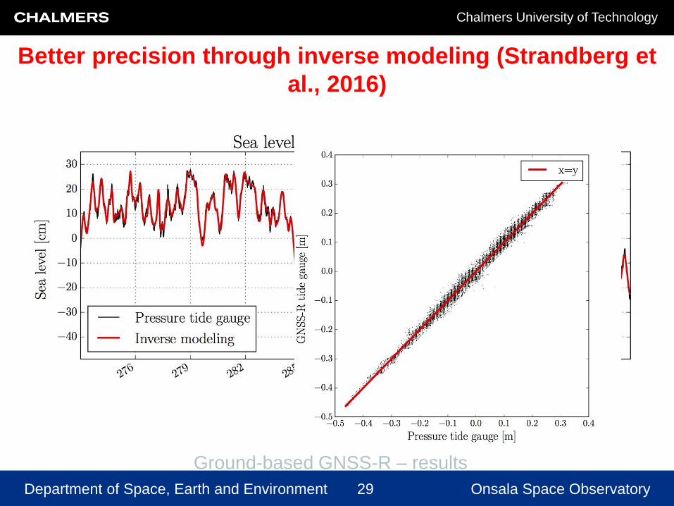
Department of Space, Earth and Environment 29 Onsala Space Observatory
Chalmers University of Technology
Ground-based GNSS-R – results
Better precision through inverse modeling (Strandberg et
al., 2016)

Department of Space, Earth and Environment 30 Onsala Space Observatory
Chalmers University of Technology
GPS

Department of Space, Earth and Environment 31 Onsala Space Observatory
Chalmers University of Technology
GPS and Galileo

Department of Space, Earth and Environment 32 Onsala Space Observatory
Chalmers University of Technology
GNSS-R - Results for different
GNSS combination

Department of Space, Earth and Environment 33 Onsala Space Observatory
Chalmers University of Technology
Increased robustness• Improving the signal (backward-compatible?)
– Increased signal power; Improved frequency standards;
– New and more signals (carrier frequencies)
– New coding and increased bandwidth
– Multi-constellation GNSS
• Augmentation, integrity, monitoring
– Atmospheric corrections, Resistance/warning against interference
– High-latitudes solutions
• Receiver systems
– Multipath and interference resistance
– GNSS Interoperability, Multi-constellation GNSS
– Sensor fusion

Department of Space, Earth and Environment 34 Onsala Space Observatory
Chalmers University of Technology
Expectations for the future• GNSS is used in many more applications
– Scientific, Commercial, Personal
– Positioning, Navigation and Time (PNT)
• GNSS weaknesses mitigated
– Augmentation e.g. PNT at high-latitudes
– Modelling Troposphere and Ionosphere
– Resistance/warning against interference
• Additional technical achievements
– GNSS Interoperability and Sensor Fusion
– Augmentation (Galileo OS/CS) from satellite or ground
– Additional signals => robustness and redundancy
Department of Space, Earth and Environment 35 Onsala Space Observatory
Chalmers University of Technology
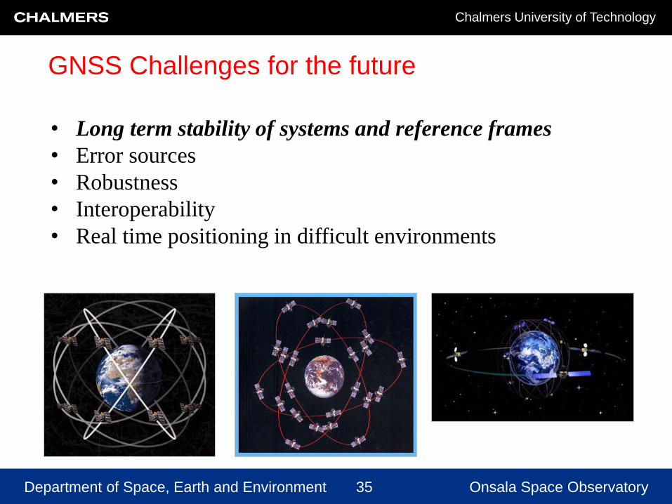
GNSS Challenges for the future
• Long term stability of systems and reference frames
• Error sources
• Robustness
• Interoperability
• Real time positioning in difficult environments
Department of Space, Earth and Environment 36 Onsala Space Observatory
Chalmers University of Technology
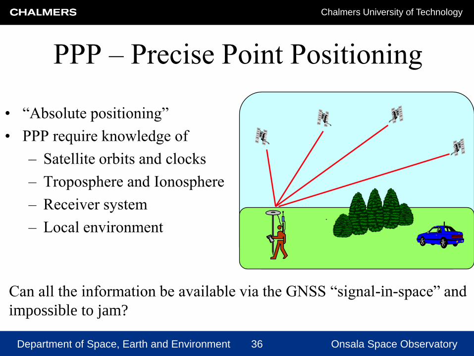
PPP – Precise Point Positioning
Can all the information be available via the GNSS “signal-in-space” and
impossible to jam?
• “Absolute positioning”
• PPP require knowledge of
– Satellite orbits and clocks
– Troposphere and Ionosphere
– Receiver system
– Local environment
Department of Space, Earth and Environment 37 Onsala Space Observatory
Chalmers University of Technology
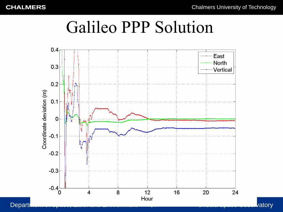
Galileo PPP Solution

Department of Space, Earth and Environment 38 Onsala Space Observatory
Chalmers University of Technology
Comparison of PPP solutions:
GPS vs Galileo