Central Coalfields Limited
58
A Mini Ratna Company Addendum EIA & EMP For One Time Capacity Enhancement of Existing Karo OCP (Quarry-I) Application for one time increase in capacity under clause 7(ii) of EIA Notification. Project Area (Ha) Mine Capacity (MTPA) Existing Proposed Existing Proposed 226.33 226.33 1.50 2.50 (Bokaro & Kargali Area) Central Coalfields Limited (January, 2016) Prepared at Regional Institute- III Central Mine Planning & Design Institute Ltd. (A Subsidiary of Coal India Ltd.) Gondwana Place, Kanke Road Ranchi-834008, Jharkhand
Transcript of Central Coalfields Limited

A Mini Ratna Company
Addendum EIA & EMP For One Time Capacity Enhancement
of Existing Karo OCP (Quarry-I)
Application for one time increase in capacity under clause 7(ii) of EIA Notification.
Project Area (Ha) Mine Capacity (MTPA)
Existing Proposed Existing Proposed
226.33 226.33 1.50 2.50
(Bokaro & Kargali Area)
Central Coalfields Limited
(January, 2016)
Prepared at
Regional Institute- III
Central Mine Planning & Design Institute Ltd. (A Subsidiary of Coal India Ltd.) Gondwana Place, Kanke Road
Ranchi-834008, Jharkhand

CONTENTS
Particulars Plate/ Annexure No.
Page No.
Form-I
Addendum EIA & EMP Plate Name Plate No. After Page No.
Location Plan I
Toposheet of Buffer zone II
Land Use Plan III
Geological Plan IV
Final Stage Quarry Plan V
Final Stage Dump Plan VI
Location of Sampling Stations VII
Isopleth of PM10 Without Control Measures VIII
Isopleth of PM10 With Control Measures IX
Post Mining Land Use Plan X
Annexure Name Annexure No. After Page No.
Approval of Karo OCP by CCL Board I
Half Yearly Compliance Report II
MoEF Guidelines for Expansion Project III
Forestry Clearance Letter IV
V

1
Addendum EIA & EMP For One Time Capacity Enhancement of Existing Karo OCP (Quarry-I)
(Proposed Capacity 2.50 MTPA)
1 Introduction
Karo OCP (Quarry-I) is located in Bokaro district of Jharkhand and lies in the B&K Area of CCL.
The PR of Karo OCP was approved by CIL Board for a rated capacity of 3.5 MTY in August, 2006 with an initial capital of 96.53 Crs. Keeping in view the huge demand of coking and non-coking coal, it became necessary to produce maximum possible coal from the mine. As per approved PR, two opencast mines were planned separately in the name of Quarry-I (1.5 MTPA) and Quarry-II (2.00 MTPA).
The EC for this project was granted for 1.50 MTPA capacity in Quarry-I only (limited to part area having released forest land and non-forest land only) vide letter number J-11015/544/2009-IA. II(M) dated 24.12.2014 within lease area of 226.33 Ha (instead of original area of 570.26 Ha). Refer Annexure-II for a copy of half-yearly compliance report.
This opencast mine (Quarry-I) is presently being worked by Shovel Dumper combination. The performance of mine for the last three years is given below.
Year Coal (MT) OBR(Mcum) SR(Cum/T)
2012-2013 0.62 0.33 0.53
2013-2014 0.77 0.39 0.51
2014-2015 1.63 0.68 0.42
Present Proposal
The Project Report of Karo Expansion OCP (11/15 MTPA) with integrated washery was in principally approved on 21.05.2013 by CCL Board. As the forest land in remaining part of the project is awaiting stage-I clearance from MoEF&CC, it is necessary to increase the EC capacity of existing Quarry-I to meet demand of coal in the intervening period. The Public Hearing of Karo Expansion OCP (11/15 MTPA) with integrated washery was held on 05.01.2016, and final EIA & EMP is under preparation.
The present proposal envisages opencast mining upto seam VI/VII/VIII combined in Quarry-I only at an enhanced capacity @ 2.50 MTPA with one time increase in capacity as per MoEF&CC guidelines issued vide office memorandum dated 19.12.2012 & subsequent amendment vide memorandum dated 07.01.2014.
Salient Features of MoEF&CC Guidelines
MoEF&CC issued guidelines for granting environmental clearance for expansion of coal mining projects involving one time production capacity expansion of upto 25% in the existing operation. The guidelines have been issued vide office memorandum

2
No.J-11015/30/2004- IA.II(M) dated 19.12.2012 & subsequent amendment vide memorandum dated 07.01.2014. Amendment vide memorandum dated 07.01.2014 states that:- “for expansion proposals of existing coal mining projects having production capacity upto 8.0 MTPA as per the EC letter, the limit of capacity expansion may be considered as 50% or incremental production of 1.00 MTPA, whichever is more, in the existing mining operation, within the existing mine lease area”. All other stipulations stated in earlier O.M. dated 19.12.2012 will continue to apply in such cases. The Addendum EIA & EMP with necessary enclosures are being submitted for EC of Karo OCP Quarry I (2.50 MTPA capacity proposed as per the new guidelines).
The salient features of the guidelines: Expansion projects for coal mining fall into two categories (i) projects that have obtained EC under the EIA notification 1994 and (ii) projects that have obtained EC under the EIA Notification,2006. The EAC may consider exempting Public Hearing for the capacity expansion proposals of existing coal mining projects, which have obtained EC under any one of these Notifications, which are for one time capacity expansion of up to 25% in the existing mining operation, within the existing mine lease area, under clause 7(ii) of the EIA Notification 2006 subject to the following conditions:-
Para Conditions Actual Status
1 Such an exemption would be considered for those expansion projects which have obtained prior EC and have undergone Public Hearing during the process of obtaining EC.
Public Hearing was held on 24.05.2007 during the process of obtaining EC under EIA Notification, 2006.
2 The proposal is for one time capacity expansion of up to 25% in the existing coal mining operation.
This proposal is for one time capacity expansion of 1.00 MTPA in the existing coal mining operation.
3 There is no additional mine lease area involved.
There is no increase in existing lease area of 226.33 Ha.
4 There is no change in mining method (underground to opencast).
There is no change in mining method.
5 Application for the expansion project shall include a certified report of the Regional Office of the MoEF on the issue of compliance of EC conditions stipulated for the existing project for which EC for the expansion is being sought and necessary action taken there upon by the EAC, in terms of the MoEF Circular No.J-11011/618/2010-IA.II (1) dated 30.5.2012.
Inspection by Director MoEF&CC, Regional Office, Ranchi was done on 22.01.2016.
6 Details of the court cases, if any, pending in any Court of Law against
There is no court case pending in any Court of Law against the

3
the project as well as directions passed by any Court relating to the project shall be furnished by the proponent directly to the Environment Appraisal Committee (EAC). The EAC will deliberate upon the same and the gist of the discussion will be reflected in the minutes of the EAC meetings.
project.
7 Details of notices, if any, issued to the project under the Section 5 of the Environment (Protection) Act, 1986 will be reported by the proponent directly to the EAC. The EAC will deliberate upon the same and the gist of the discussion will be reflected in the minutes of the EAC meeting.
No notice has been issued to the project under the Section 5 of the Environment (Protection) Act, 1986
8 If the project falls in a Critically Polluted Area (CPA) wherein the moratorium has been lifted, the EAC shall examine the measures required to be implemented by the project proponent under the Environment Action Plan prepared by the State Pollution Control Board concerned and status of their Implementation. In such cases, the EAC shall also examine the monitoring data furnished by the project proponent of the environmental quality of the study area /CPA in which the project falls and after due diligence, decide if any additional mitigative measures are required for the expansion.
The project does not fall in a Critically Polluted Area (CPA).
9 25% expansion in production capacity is subject to a ceiling of 2 MTPA of additional production where the transportation of the additional production is proposed by road and of 5 MTPA of additional production if such transportation is proposed by means of a conveyor and /or rail transport.
The coal dispatch is done l through Kargali Washery Railway Siding at about 4.0 km from the mine. The transport upto Kargali Washery/Railway Siding is done by CCL road.
Amendment vide memorandum dated 07.01.2014
10 For expansion proposals of existing coal mining projects having production capacity upto 8.0 MTPA as per the EC letter, the limit of capacity expansion may be considered as 50% or incremental production of 1.00 MTPA, whichever is more, in the existing mining operation, within the existing
The proposed increase in capacity is from 1.50 MTPA to 2.50 MTPA.

4
mine lease area”. All other stipulations stated in earlier O.M. dated 19.12.2012 will continue to apply in such cases.
The one time production capacity expansion of Karo OCP Quarry I (2.50 MTPA capacity), B&K Area, Central Coalfields is a fit case under the guidelines issued vide office memorandum No.J-11015/30/2004-IA.II(M) dated 19.12.2012 and subsequent amendment.
This Addendum EIA & EMP for Karo OCP Quarry I (2.50 MTPA capacity) without increase in lease area and coal dispatch through Kargali Washery/Railway Siding is put up for kind approval of Expert Appraisal Committee (T&C) of MOEF.
Identification of project & project proponent
The project under consideration, i.e. Karo OCP Quarry I (2.50 MTPA capacity) is administratively under B&K Area of CCL headed by General Manager, B&K Area. Geologically, it falls in East Bokaro Coalfield in Bokaro District of Jharkhand. The mailing address of the Project Officer is given below: Karo OCP, B&K Area, Central Coalfields Limited. PO- Bermo Dist- Bokaro, Pin – 829104 Location & Communication
The project is located in the north-eastern part of East Bokaro Coalfield. This OCP lies to the north of Bokaro Colliery and Bermo Quarry of DVC, to the west of Amlo Project and to the east of Konar Project. The block is located between the latitude (N) – 23047’02” – 23048’38” and longitude (E) – 85057’27” – 85058’38”. It is shown in Plate No.-II (Topo sheet scale 1:50000). East Bokaro Coalfield lies in the Gomo-Barkakana-Dehri-On-Sone loop line of Eastern Railway. Nearest railway station is Bermo railway station on this line, which is located at a distance of about 5 Km. from the proposed Karo OCP Quarry I (2.50 MTPA capacity). The east-west running Gomia- Jarangdih- Phusro- Jaina More road, which meets the Bisnugarh-Petarbar road and Dhanbad-Ramgarh road, connects the coalfield with Hazaribagh, Dhanbad and Ranchi. This road is located to the south of Kaveri (Karo-II) block. The block is also connected Bokaro Thermal Power Station in the west and Phusro in the southeast by metal road. The nearest township is Phusro, which is situated at a distance of about 7 Km. Phusro is connected to the G.T. Road by Phusro and Dumri road. The nearest Air Port is Ranchi. However, there is a small airstrip located near Sawang colliery. Refer Location plan at Plate-I.
5
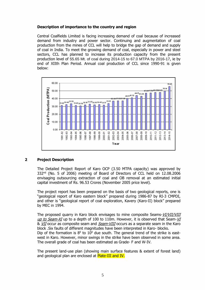
Description of importance to the country and region
Central Coalfields Limited is facing increasing demand of coal because of increased demand from industry and power sector. Continuing and augmentation of coal production from the mines of CCL will help to bridge the gap of demand and supply of coal in India. To meet the growing demand of coal, especially in power and steel sectors, CCL has planned to increase its production capacity from the present production level of 55.65 Mt. of coal during 2014-15 to 67.0 MTPA by 2016-17, ie by end of XIIth Plan Period. Annual coal production of CCL since 1990-91 is given below:
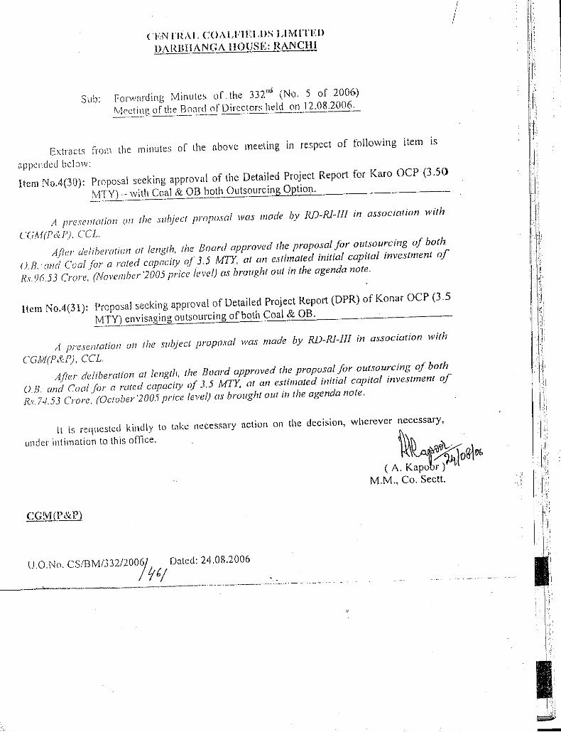
2 Project Description The Detailed Project Report of Karo OCP (3.50 MTPA capacity) was approved by 332nd (No. 5 of 2006) meeting of Board of Directors of CCL held on 12.08.2006 envisaging outsourcing extraction of coal and OB removal at an estimated initial capital investment of Rs. 96.53 Crores (November 2005 price level). The project report has been prepared on the basis of two geological reports, one is “geological report of Karo eastern block” prepared during 1986-87 by RI-3 CMPDI, and other is “geological report of coal exploration, Kavery (Karo-II) block” prepared by MEC in 1994.
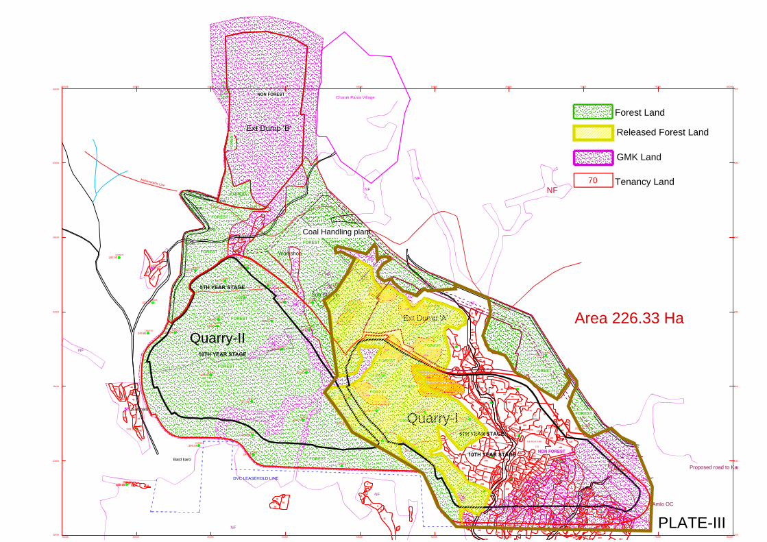
The proposed quarry in Karo block envisages to mine composite Seams-VI/VII/VIII up to Seam-XI up to a depth of 100 to 110m. However, it is observed that Seam-VI & VII occur as composite seam and Seam-VIII occurs as a separate seam in the Karo block .Six faults of different magnitudes have been interpreted in Karo- blocks. Dip of the formation is 80 to 100 due south. The general trend of the strike is east-west in Karo. However, minor swings in the strike have been observed in some area. The overall grade of coal has been estimated as Grade- F and W-IV. The present land-use plan (showing main surface features & extent of forest land) and geological plan are enclosed at Plate-III and IV.

6
Mining System The mining and geological conditions of the mine are as follows: - (a) Multiple seams to be worked (b) Steep gradient of 8-10 degree of the coal seams. (c) Variable thickness of OB/Partings. Considering the above mining and geological conditions, shovel-dumper mining system with horizontal slicing has been envisaged for working this OC mine. O.B. Removal The total balance volume of OB to be removed from Quarry-I is estimated as 28.64 Mcum. It is envisaged to dump 6.0 Mcum externally and balance 22.64 Mcum internally. The external dumping would be undertaken during the initial years. Approach road to project has been designed at a distance of 20 m to the north side from toe of external dump. Proposed route of Karo nala diversion has been kept further 80 m from approach road. Dumpers of 35 T capacity have been proposed for OB transportation. Garland drain and retention wall where ever required around external dump have been provided from safety point of view.
The project envisages following dumping option for Quarry-I
I. External Dump I: Area – 37.07 Ha, Highest dump level- +340m (about 30 m above adjoining ground level) and Capacity- 6.0 Mcum.
II. Internal Dump: Area – 84.30 Ha, Highest dump level- +280m (about 20-25 m above adjoining ground level) and Capacity- 22.64 Mcum .
Drilling and Blasting 160mm diameter RBH Electric drills are envisaged for drilling in Top OB and coal benches. One wagon drill of 100-120 mm diameter is envisaged for drilling in thin partings and dirt bands. Mine Boundary for Quarry-1 Northern Boundary Along the incrop of Seam-VI/VII/VIII combined. The present extent of mining has also been considered while defining this boundary. Western Boundary Along faults F3, which is the common floor boundary with Quarry-II. Southern Boundary At a distance of about 30m from the DVC lease line. Eastern Boundary Along the fault F1b that acts as the common floor boundary of this quarry with Amlo (Dhori West) OCP in the east of Quarry-I. Amlo has already worked upto the upthrow side of the fault and the area is free from any OB Dump.

7
Mining & Geological Characteristics of the Quarry
Parameters Unit Min Max
Mineable reserves (MT) 39.04
Total OB (MCum) 28.64
Average Stripping Ratio (Cum/T) 0.73
Capacity (MTY) 2.5
Length along strike at floor Km 0.56 1.09
Length along strike at surface Km 0.75 1.19
Width along dip at floor Km 0.98 1.2
Width along dip at surface Km 1.39 1.90
Depth of quarry m 125
Area of Excavation at floor Sqkm 1.07
Area of Excavation at surface Sqkm 1.48
Minable Reserve & Life of Mine Balance mineable reserves for Quarry-I (as on 31-03-2015) are estimated as 39.04 M.tes with a corresponding volume of OBR of 28.64 Mm3 at an average stripping ratio of 0.73 m3/te. Balance life of mine is 17 years in present proposal. The break-up of the seam wise coal reserves and total volume of OB/partings are given below. Calendar Program
Year Coal (MTPA) TOTAL OB (MCUM) S.R Cum / Te
1 2.5 1.9 0.77
2 2.5 1.92 0.77
3 2.5 1.92 0.77
4 2.5 1.92 0.77
5 2.5 1.92 0.77
6 2.5 1.83 0.73
7 2.5 1.83 0.73
8 2.5 1.83 0.73
9 2.5 1.83 0.73
10 2.5 1.83 0.73
11 2.5 1.83 0.73
12 2.5 1.78 0.71
13 2.5 1.78 0.71
14 2.5 1.78 0.71
15 2.5 1.78 0.71
16 0.89 0.50 0.56
17 0.66 0.46 0.70
Total 39.04 28.64 0.73

8
Water Demand
Total estimated water demand is 750 m3/day. This is proposed to be met from mine water pumping.
Topography & Drainage
The entire topography of the block is rugged and pronounced with hills and valleys. The ground elevation varies from a maximum of 335m in north to a minimum of 236m in the south of the block. The general slop is towards south. The drainage of the block is controlled by Karo nallah which cross the area and flow towards south and ultimately flow into Damodar river between DVC Bermo OCP and Kargali Colliery. The block also has ponds in the south-eastern part. Source of Electrical Power Supply (As per PR):
The estimated connected loads, maximum demand and energy consumption at optimum production level for Karo opencast project are as summarized below-
(A) Connected load : 10987 KW (B) Load In operation : 8499 KW (C) Maximum power demand : 5336 KVA (D) Annual energy consumption : 23.69 MKWh (E) Energy consumption per tonne of coal : 6.77 KWh
The existing system of incoming line of 3.3 KV feeder of regional sub station at Kargali have already been touched optimum level. Hence further loading in this sub station with the existing incoming arrangement cannot be done. Considering the above constraints of regional sub station, it is proposed that the in coming power at 33KV would be drawn from DVC & BTPS through an independent 33KV single circuit over head transmission line with ACSR ‘DOG’ conductor. The feeder length would be 17 Km. approximately. The project would establish 2 nos. sub station of 2x5MVA 33/6.6 KV each. Coal Handling & Dispatch System
Crushed coal (-100 mm size) produced from the mine will be sent by tipping trucks to nearby Kargali washery/ Kargali railway siding or any other siding for rail dispatch.
Land Use Details
SN Particular
Land Requirement of Quarry-I (Ha)
Released
Forest Non-forest Total
1 Quarry 46.69 98.70 145.39
2 External OB dump 21.63 15.44 37.07
3 Haul road 0.00 0.00 0.00
4 CHP 0.00 1.50 1.50
5 Infrastructure 3.93 0.13 4.06
6 Safety zone 5.18 15.72 20.90

9
7 Colony 0.00 14.41 14.41
8 Land for nala diversion
& Road outside lease 0.00 3.00 3.00
Total 77.43 148.90 226.33
Stage-II FC granted for diversion of total 77.43 ha forest land falling in core zone vide letter number: F.No.8-22/2003-FC Dated 31st March 2004. Refer Annexure-IV for reference.
3 Description of the Environment
Ambient Air Quality Ambient air quality study was done in core & buffer zone of Karo OCP during Post-monsoon season of 2004-05 at the following stations. The location of sampling stations is shown on Plate-VII.
Sl. No.
Location Name Location
Code Direction from Site
Distance (km)
Height of the sampling point (m)
1 Core Zone SA - 1 -- -- 3.5
2 Makoli village Sa – 2 SE 3.5 3.5
3 Pusro village SA - 3 S 4.0 3.5
4 Baid Karo village SA - 4 W 2.0 3.0
5 Baridih village SA - 5 N 5.0 3.5
6 Birni village SA - 6 NE 6.0 3.5
RATIONALE BEHIND SAMPLING
CORE ZONE (SA-1) This location is situated in the proposed mining area. It is selected to assess the immediate effects in the mining area and the present data will help to know the increase in pollution levels due to mining operation activities. MAKOLI VILLAGE (SA-2) This location is situated at 3.5 km towards East-South direction and it is selected for Air Quality Monitoring to assess the effects of pollutants in the populated area. PUSRO VILLAGE (SA-3) This location is situated at 4.0 km distance towards south direction from the proposed mine area. Phusro is a small town and thickly populated with high traffic of light and heavy vehicles. It is selected to assess the effect of pollutants in the populated area. BAID KARO VILLAGE (SA-4) This location is situated at a distance of 2,0 Km towards west direction from the proposed mine area. It is selected to assess the effect of pollutants in the populated area. BARIDIH VILLAGE (SA-5)

10
This location is situated at 5 Km distance from site towards north direction and it is selected to assess the effect of pollutants in the populated area. BIRNI VILLAGE (SA-6) This location is situated at a distance of 6 Km from the proposed mine area towards North East direction and it is selected to assess the effect of pollutants in the populated area due to upwards and downwards wind.
OBSERVATION
The observations made during the post monsoon season of air quality data generated at Core Zone, Karo OCP have been presented in the Tabular form. The 24 hourly concentration of SPM, RPM, SO2 and Nox and have been presented for all the six sampling stations in the study area of Karo OCP in Table below:
Sl. No.
Pollutant Location
Code Min.
98th percentile
Max. Average value
1 SPM
SA - 1 67.0 198.79 198.79 156.32
SA - 2 106.18 192.31 192.31 151.70
SA - 3 117.84 195.59 195.59 155.84
SA - 4 103.79 198.54 198.54 139.29
SA - 5 101.87 198.16 198.16 155.52
SA - 6 103.01 185.42 188.60 135.33
2 RPM
SA - 1 16.31 47.70 47.70 37.50
SA - 2 24.42 43.70 43.70 34.87
SA - 3 25.92 43.02 43.02 34.30
SA - 4 25.94 49.63 49.63 36.05
SA - 5 26.48 50.48 50.48 41.42
SA - 6 24.72 44.49 45.26 32.20
3 SO2
SA - 1 4.8 17.5 17.51 12.08
SA - 2 3.2 17.90 17.90 9.4
SA - 3 7.9 26.40 26.40 16.04
SA - 4 1.6 18.90 18.90 7.41
SA - 5 2.4 13.10 13.10 6.55
SA - 6 3.6 15.25 17.20 8.41
4 NOX
SA - 1 6.46 20.60 20.60 14.41
SA - 2 10.4 25.50 25.50 18.23
SA - 3 10.6 20.90 20.90 15.76
SA - 4 2.3 15.60 15.60 18.87
SA - 5 2.34 15.40 15.40 8.62
SA - 6 7.3 19.50 20.60 13.81
Ambient Noise Level Observations
Stn. No.
Location Name
Zone Type Leq Noise Level, dB(A)
Day time
Night time
CPCB LIMITS
Day time Night time
SN1 Kaveri ProjectKaro OCP Karo OCP Core zone (Industrial)
43.67 39.10 75 70
SN2 Sarubera village Buffer zone (Residential)
42.53 38.47 55 45
SN3 Makoli village 45.00 41.33
SN4 Kargali village 42.73 39.57

11
SN5 Barkikuri village 43.57 39.97
Water quality status For assessing the water quality, 4 location water-sampling locations were selected as per detail given below and samples were collected for analysis on 11-10-2004.
Stn No.
Name of sampling station Location of sampling station and its description
Type of sample
W1 Barki Jora Nalla at Upstream
Upstream of Karo Expansion OCP Surface water
W2 Barki Jora Nalla at Downstream
Downstream of Karo Expansion OCP -do-
W3 Damodar River, after confluence of Barkijora Nala
Downstream of Karo Expansion OCP do-
W4 Well Water, Karo-I Project
Drinking water source Ground water
Observations
WATER QUALITY DATA Project : Karo-OCP Season : Post Monsoon Location : Barkijora Nalla U/S (W1)
Sl. No.
Parameter Unit Result IS:2296-1982
Norms
1 PH - 6.98 6.5 – 8.5
2 Colour Hazen Units 10 10
3 Temperature oC 23.5 -
4 Turbidity NTU 118 -
5 Total suspended solids mg/l 106 -
6 Total dissolved solids mg/l 403 500
7 Total volatile solids mg/l 28 -
8 Dissolved Oxygen mg/l 5.4 4.0
9 BOD - 5 days, 20oC mg/l 2.0 2.0
10 COD mg/l 22 -
11 Oil & grease mg/l Nil -
12 Residual chlorine mg/l Nil -
13 Chloride (as CI) mg/l 51 250
14 Flouride (as F) mg/l 0.18 1.5
15 Sulphate (as SO4) mg/l 9 400
16 Sulphide (as S) mg/l Nil -
17 Cyanide (as CN) mg/l Nil 0.05
18 Insecticides/pesticides mg/l Nil Absent
19 Phenols (as C6H5OH) mg/l <0.001 0.002
20 Alkalinity to phenolphthalein mg/l Nil -
21 Alkalinity to methyl orange mg/l 99 -
22 Chromium (as Cr) mg/l <0.01 -
23 Copper (as Cu) mg/l <0.01 1.5

12
24 Selenium (as Se) mg/l <0.01 0.01
25 Arsenic (as As) mg/l <0.01 0.5
26 Barium (as Ba) mg/l <0.01 -
27 Cadmium mg/l <0.01 0.01
28 Nickel (as Ni) mg/l <0.01 -
29 Boron (as B) mg/l <0.01 -
30 Mercury (as Hg) mg/l <0.001 -
31 Silver (as Ag) mg/l <0.01 -
32 Lead (as Pb) mg/l <0.01 0.1
33 Zinc (as Pb) mg/l <0.01 15
34 Iron (as Fe) mg/l 1.76 0.3
35 Calcium (as Ca) mg/l 22 -
36 Magnesium (as Mg) mg/l 4 -
37 Total Nitrogen (as N) mg/l 0.10 -
38 Percent sodium % 23.2 -
39 Coliform organisms MPN/100ml >1100 -
Project : Karo- OCP Season :Post Monsoon Location : Barkijora Nalla D/S (W2)
Sl. No.
Parameter Unit Result IS:2296-1982
Norms
1 PH - 7.16 6.5 – 8.5
2 Colour Hazen Units 10 10
3 Temperature oC 23.0 -
4 Turbidity NTU 124 -
5 Total suspended solids mg/l 113 -
6 Total dissolved solids mg/l 504 500
7 Total volatile solids mg/l 31 -
8 Dissolved Oxygen mg/l 5.6 4.0
9 BOD - 5 days, 20oC mg/l 2.0 2.0
10 COD mg/l 25 -
11 Oil & grease mg/l Nil -
12 Residual chlorine mg/l Nil -
13 Chloride (as CI) mg/l 46 250
14 Flouride (as F) mg/l 0.20 1.5
15 Sulphate (as SO4) mg/l 10 400
16 Sulphide (as S) mg/l Nil -
17 Cyanide (as CN) mg/l Nil 0.05
18 Insecticides/pesticides mg/l Nil Absent
19 Phenols (as C6H5OH) mg/l <0.001 0.002
20 Alkalinity to phenolphthalein mg/l Nil -
21 Alkalinity to methyl orange mg/l 136 -
22 Chromium (as Cr) mg/l <0.01 -
23 Copper (as Cu) mg/l <0.01 1.5
24 Selenium (as Se) mg/l <0.01 0.01
25 Arsenic (as As) mg/l <0.01 0.5
26 Barium (as Ba) mg/l <0.01 -
27 Cadmium mg/l <0.01 0.01

13
28 Nickel (as Ni) mg/l <0.01 -
29 Boron (as B) mg/l <0.01 -
30 Mercury (as Hg) mg/l <0.001 -
31 Silver (as Ag) mg/l <0.01 -
32 Lead (as Pb) mg/l <0.01 0.1
33 Zinc (as Pb) mg/l <0.01 15
34 Iron (as Fe) mg/l 1.82 0.3
35 Calcium (as Ca) mg/l 24 -
36 Magnesium (as Mg) mg/l 5 -
37 Total Nitrogen (as N) mg/l 0.12 -
38 Percent sodium % 23.6 -
39 Coliform organisms MPN/100ml >1100 -
Project : Karo- OCP Season : Post Monsoon
Location Confluence point of Barkijora River and Damodar River (W3)
Sl. No.
Parameter Unit Result IS:2296-1982
Norms
1 PH - 7.28 6.5 – 8.5
2 Colour Hazen Units 15 10
3 Temperature oC 23.6 -
4 Turbidity NTU 138 -
5 Total suspended solids mg/l 117 -
6 Total dissolved solids mg/l 343 500
7 Total volatile solids mg/l 37 -
8 Dissolved Oxygen mg/l 5.8 4.0
9 BOD - 5 days, 20oC mg/l 2.0 2.0
10 COD mg/l 29 -
11 Oil & grease mg/l Nil -
12 Residual chlorine mg/l Nil -
13 Chloride (as CI) mg/l 26 250
14 Flouride (as F) mg/l 0.22 1.5
15 Sulphate (as SO4) mg/l 14 400
16 Sulphide (as S) mg/l Nil -
17 Cyanide (as CN) mg/l Nil 0.05
18 Insecticides/pesticides mg/l Nil Absent
19 Phenols (as C6H5OH) mg/l <0.001 0.002
20 Alkalinity to phenolphthalein mg/l Nil -
21 Alkalinity to methyl orange mg/l 111 -
22 Chromium (as Cr) mg/l <0.01 -
23 Copper (as Cu) mg/l <0.01 1.5
24 Selenium (as Se) mg/l <0.01 0.01
25 Arsenic (as As) mg/l <0.01 0.5
26 Barium (as Ba) mg/l <0.01 -
27 Cadmium mg/l <0.01 0.01
28 Nickel (as Ni) mg/l <0.01 -
29 Boron (as B) mg/l <0.01 -
30 Mercury (as Hg) mg/l <0.001 -
31 Silver (as Ag) mg/l <0.01 -
32 Lead (as Pb) mg/l <0.01 0.1
33 Zinc (as Pb) mg/l <0.01 15
34 Iron (as Fe) mg/l 1.90 0.3
35 Calcium (as Ca) mg/l 26 -
36 Magnesium (as Mg) mg/l 10 -

14
37 Total Nitrogen (as N) mg/l 0.16 -
38 Percent sodium % 26.7 -
39 Coliform organisms MPN/100ml >1100 -
Project : Karo- OCP Season : Post Monsoon Location Well Water, Kaveri Project (W4) :
Sl. No.
Parameter Unit Result IS: 10500-1991
Norms
1 PH - 6.94 6.5 - 8.5
2 Colour Hazen Units < 5.0 10
3 Temperature oC 22.3 -
4 Turbidity NTU 8 10
5 Total suspended solids mg/l 18 -
6 Total dissolved solids mg/l 823 -
7 Total volatile solids mg/l 10 -
8 Dissolved Oxygen mg/l 5.2 -
9 BOD - 5 days, 20oC mg/l 2.0 -
10 COD mg/l 24 -
11 Oil & grease mg/l Nil -
12 Residual chlorine mg/l Nil 0.2
13 Chloride (as CI) mg/l 128 250
14 Flouride (as F) mg/l 1.26 1.5
15 Sulphate (as SO4) mg/l 59 250
16 Sulphide (as S) mg/l Nil -
17 Cyanide (as CN) mg/l Nil 0.05
18 Insecticides/pesticides mg/l Nil Absent
19 Phenols (as C6H5OH) mg/l Nil 0.001
20 Alkalinity to phenolphtahline
mg/l Nil -
21 Alkalinity to methyl orange
mg/l 296
-
22 Chromium (as Cr) mg/l <0.01 0.05
23 Copper (as Cu) mg/l <0.01 0.05
24 Selenium (as Se) mg/l <0.01 0.01
25 Arsenic (as As) mg/l <0.01 0.05
26 Barium (as Ba) mg/l <0.01 -
27 Cadmium mg/l <0.01 0.01
28 Nickel (as Ni) mg/l <0.01 -
29 Boron (as B) mg/l <0.01 -
30 Mercury (as Hg) mg/l <0.001 0.001
31 Silver (as Ag) mg/l <0.01 -
32 Lead (as Pb) mg/l <0.01 0.1
33 Zinc (as Pb) mg/l <0.01 5
34 Iron (as Fe) mg/l 0.78 0.3
35 Calcium (as Ca) mg/l 62 75
36 Magnesium (as Mg) mg/l 31 30
37 Total Nitrogen (as N) mg/l 0.32 -
38 Percent sodium % 22.8 -
39 Coliform organisms MPN/100ml 93 Absent
Comparison of Previous Water Quality Status vis-à-vis Present Status

15
NOTE: The concentration of all parameters except pH is in mg/l.
Conclusion: It is observed that the TSS which was found to be quiet high during baseline study may have been due to surface runoff from previous rains. However, during routine monitoring the TSS value has ranged from 28-40 mg/l. this has been primarily due to sedimentation in mine sump / pond , O&G trap at workshop and garland drains. All other parameters as given above are also well within the limit.
4 Detail of Anticipated Environmental impacts & Mitigation Measures
Air Pollution Control
Sources of air pollution The main sources of air pollution are identified as- 1) Drilling & blasting in coal & OB benches. 2) Coal & OB transportation inside the mine. 3) Coal crushing & transportation from mine to Railway Siding. 4) Wind erosion from OB Dump.
Predicted Concentrations of SPM & PM10 For 2.50 MTPA Peak Coal Production
Estimation of dust (TSP) generation at Karo Expansion OCP
The coal production from Karo OCP at the time of data generation (2004-05) for EIA & EMP study was 1.07. This air quality modelling has been done for a peak coal production level of 2.50 MTPA. Micrometeorological and microclimatic parameters were recorded by M/S PDIL, Sindri, Dhanbad by installing one meteorology station in core zone of Karo OCP.
During the study period from 6th October, 2004 to 31st December, 2004, hourly reading of wind velocity, wind direction, temperature, relative humidity, cloud cover and rainfall data were recorded. The model was run on 24 hours input meteorological file based on the readings taken on 01-12-2004 which represents typical meteorological condition found during the study period.
The incremental coal production is expected to reach a level of 4333 TPD at the peak coal production target of 2.50 MTPA. This coal is proposed to be transported to
Parameters Status as per routine monitoring study (mg/l) MoEF Limit (Schedule-
VI) Sept’ 2014
Dec’ 2014
Mar’ 2015
June’ 2015
Sept’ 2015
pH 7.40 6.94 7.10 7.10 7.44 5.5-9.0
TSS 28 40 32 28 31 100
COD 36 44 36 40 38 250
BOD 2.00 2.00 2.00 2.00 2.00 30
Oil & Grease <2.0 <2.0 <2.0 <2.0 <2.0 10
Nitrate as N 2.2 2.2 2.2 1.3 1.4 10
Iron as Fe <0.06 <0.06 <0.06 <0.06 <0.06 3

16
Kargali Railway Siding by tipping trucks. The increase in activities like coal production, loading, transportation, unloading and storage @ 4333 Tonnes per day will cause adverse impact on the AAQ status. The future anticipated impact on AAQ due to dust emission from various activities related to the proposed coal production has been calculated as per the following table for the future scenario-
Input Data for AQIP
Annual Peak increamental coal production (MTPA) 1.43
Stripping Ratio 0.70
Annual Peak increamental OB generation (Mcum/yr) 1.00
No. of operation days per annum 330.00
Specific gravity of coal (Tonne/m3) 1.60
Density of OB (t/m3) 2.40
Drill hole to hole distance (m) Length Width Depth (D) No. of drill holes
Coal Bench 3.5 3.5 10 32
OB Bench 3.5 3.5 10 36
Capacity of Dumper for OB (Tonne) 35
Avg distance traveled per trip for OB dumping (km) 2.0
Active OB dump Area (Ha) 12.36
Capacity of Dumper for coal (Tonne) 35.00
Avg distance traveled per trip for coal (km) 2.0
Moisture content for OB (M), (%) 4.00
Moisture content for coal (M), (%) 7.00
Sources of Emission
Area of Mine (including external OB dump) (Ha) 182.36
Area of CHP (Ha) 1.5
Length of Metaled road from mine to Kargali washery (km) 1
Assumptions
Quantity of Topsoil (TPD) = 10% of Quantity of OB (TPD)
Maximum not reclaimed OB dump Area at a time = Total OB Dump Area/3
Particulars Formula used Calculated
Vaue
Daily incremental coal production
(TPD)
Annual Peak incremental coal production (MTPA)
x No. of operation days per annum 4333.33
Daily incremental OB generation (m3/d)
Annual Peak incremental OB generation (Mcum/yr) x No. of operation days per annum
3033.33
Volume of coal (m3/d) Daily incremental coal production (TPD) / Specific
gravity of coal (Tonne/m3) 2708.33
Quantity of OB (TPD) Daily incremental OB generation (m3/d) x Density
of OB (t/m3) 7280.00

17
Quantity of Topsoil (TPD) 10% of Quantity of OB (TPD) 728.00
OB Removal
Area of OB benches being blasted in a day (A), (m2)
Daily incremental OB generation (m3/d) / Depth of OB bench (m)
303.33
No. of trips for transportation of OB
per day
Daily incremental OB generation (m3/d) /
Capacity of Dumper for OB (Tonne) 208
Total vehicle km traveled for OB (VKT)
No. of trips for transportation of OB per day x
Avg distance traveled per trip for OB dumping
(km)
416.00
Coal Extraction
Area of coal benches being blasted in a day (m2)
Daily incremental coal production (TPD) / Capacity of Dumper for coal (Tonne)
270.83
No. of trips for transportation of coal per day
Daily incremental coal production (TPD) x Avg distance traveled per trip for coal (km)
123.81
Total vehicle km traveled (VKT) No. of trips for transportation of coal per day x
Avg distance traveled per trip for coal (km) 247.619048
Incremental Emissions (SPM) generation from various activities
SN Activity Incremental Emission Generation (Kg/day)
without control measures
1 Top Soil Removal Quantity of Topsoil (TPD) x Emission Factor for Topsoil
Removal (kg/t)
2 OB Removal
a Drilling No. of drill holes for OB per day x Emission Factor for
drilling in OB
b Blasting 344(Area)0.8 / (Moisture)1.9(Depth)1.8
c Dumper loading by shovel Quantity of OB (TPD) x Emission Factor for OB loading
(kg/t)
d Transportation of OB Total vehicle km traveled for OB (VKT) x Emission Factor
for OB transportation (kg/VKT)
e Unloading of OB Quantity of OB (TPD) x Emission Factor for OB unloading
(kg/t)
f Wind erosion of OB Maximum not reclaimed OB dump Area at a time(ha) x Emission Factor for Wind erosion of OB (kg/ha/hr) x 24
3 Coal Extraction
a Drilling No. of drill holes for coal per day x Emission Factor for
drilling in coal
b Blasting 344(Area)0.8 / (Moisture)1.9(Depth)1.8

18
c Dumper loading by shovel Quantity of coal (TPD) x Emission Factor for coal loading
(kg/t)
d Transportation of Coal on haul
road Total vehicle km traveled for coal (VKT) x Emission Factor
for coal transportation on haul road (kg/VKT)
Incremental Emission factor for
mine (gm/m2/s) Incremental Emission generation from mine (kg/day) x 1000
/ (Area of mine (Ha) x 10000x24x60x60)
4 CHP
a Unloading of coal Quantity of coal (TPD) x Emission Factor for coal unloading
(kg/t)
b Primary Crusher Quantity of coal (TPD) x Emission Factor for Primary
crusher (kg/t)
c Secondary Crusher Quantity of coal (TPD) x Emission Factor for Secondary
crusher (kg/t)
d Loading of coal Quantity of coal (TPD) x Emission Factor for coal loading
(kg/t)
Incremental Emission factor for
CHP (gm/m2/s) Incremental Emission generation from CHP (kg/day) x 1000
/ (Area of CHP (Ha) x 10000x24x60x60)
5 Road from mine to Kargali
washery/Siding
a Transportation of Coal on metaled
road Total vehicle km traveled for coal (VKT) x Emission Factor
for coal transportation on metaled road (kg/VKT)
Incremental Emission factor for
metaled road (gm/m/s) Incremental Emission generation from metaled road
(kg/day) x 1000 / (Length of siding (km) x 1000x24x60x60)
Incremental Emission Generation without control measures (Kg/day) = Incremental Emission
Generation without control measures (Kg/day) x Control Factor (%)
Emissions (SPM) generated from various activities
SN Activity Emission (Kg/day)
Remarks
without control
measures
with control
measures
1 Top Soil Removal 21.11 10.56
Sub-total (1) 21.11 10.56
2 OB Removal
a Drilling 39.24 11.77 50% Pit retention b Blasting 18.93 18.93

19
c Dumper loading by shovel 2.80 2.80
d Transportation of OB 532.48 266.24
e Unloading of OB 21.84 21.84
f Wind erosion of OB 118.62 59.31
Sub-total (2) 733.92 380.90
3 Coal Extraction
a Drilling 13.28 3.98
50% Pit retention
b Blasting 5.97 5.97
c Dumper loading by shovel 15.38 15.38
d Transportation of Coal on haul road 316.95 158.48
Sub-total (3) 351.59 183.81
Total (1+2+3) 1106.61 575.27
Incremental Emission factor for
mine (gm/m2/s) 7.01964E-06 3.64912E-06
4 CHP
a Unloading of coal 30.77 30.77
b Primary Crusher 1213.33 12.13
c Secondary Crusher 2773.33 27.73
d Loading of coal 30.77 30.77
Total (4) 4048.20 101.40
Incremental Emission factor for
CHP (gm/m2/s) 3.124E-03 7.82407E-05
5 Road from mine to Kargali
washery/ Siding
a Transportation of Coal by road 55.71 27.86
Incremental Emission factor for
metaled road (gm/m/s) 6.448E-04 3.224E-04
Control measures given:
1) Making Topsoil wet during removal. 2) Water sprays for drilling in OB bench & coal bench. 3) Water sprinkling of haul & metaled road. 4) Enclosure with dust extraction system at Primary & secondary Crusher. 5) Dust extraction system in drills

20
Air Quality Model A model namely, FDM Version 90121 has been used to predict the impact on the ambient air quality of the core and buffer zone of the study area due to mining operations in Karo Expansion OCP with 1.43 MTPA incremental peak capacity. The dust emission levels from mining operations are based on USEPA publications and an S&T study titled, “Development of emission factors for various mining machineries & operations in opencast coal mines (EE-27)”, which was carried out by CMPDI(HQ) during 2002 to 2008..
Predicted Concentrations of SPM
Zone Category
24 Hours average SPM concentration (µ g/ m3)
Incremental Concentration
without control
measures (BAU)
Incremental Concentration with control measures
Background/ Baseline
concentration
Total predicted
concentration without control
measures (BAU)
Total predicted
concentration with control measures
Permissible limit
A1 53.19 30.13 156.32 209.51 186.45 600
A2 0.00 0.00 151.7 151.70 151.70
A3 0.09 0.05 155.84 155.93 155.89 200 A4 0.00 0.00 139.29 139.29 139.29
A5 0.20 0.11 155.52 155.72 155.63
A6 0.28 0.16 135.33 135.61 135.49
Predicted Concentrations of PM10
Zone Category
24 Hours average PM10 concentration (µ g/ m3)
Incremental Concentration
without control
measures (BAU)
Incremental Concentration with control measures
Background/ Baseline
concentration
Total predicted
concentration without control
measures (BAU)
Total predicted
concentration with control measures
Permissible limit
A1 31.91 18.08 37.5 69.41 55.58 300
A2 0.00 0.00 34.87 34.87 34.87
A3 0.05 0.03 34.3 34.35 34.33 100 A4 0.00 0.00 36.05 36.05 36.05
A5 0.12 0.06 41.42 41.54 41.48
A6 0.17 0.09 32.2 32.37 32.29

21
Refer Plate-VIII & IX for Isopleth of PM10 without & with control measures respectively.
Historical Trend of Ambient Air Quality Parameters in Core Zone Based on Routine Monitoring Data Submitted With Half-yearly Compliance Report
Quarter Ending 24 hrs average concentration (µg/m3)
SPM PM10 SO2 NOX
Sep. 2014 158.50 95.25 <25 22
Dec. 2014 416.50 188.50 <25 20.5
Mar. 2015 375.50 183.50 <25 20
Jun. 2015 457.75 221.25 <25 21
Sept. 2015 194.00 98.00 <25 19
Five quarter average 320.45 157.30 <25 20.5
Coal Mining Standard 600 300 120 120
Conclusion on Historical Trend of Ambient Air Quality Parameters
As per prediction for 2.50 MTPA peak coal production, the predicted concentration of PM10 in core zone is 34.87 – 63.20 µg/ m3 and in the buffer zone is 32.24 - 41.51 µ g/ m3. The increment in core zone is predicted to be 18.08 µg/ m3 for PM10. It is observed that 24 Hours average concentration of PM10 based on last 5 quarters is 157.30 µ g/ m3. Even after adding the predicted increment of 18.08 µg/ m3, the resultant concentration in core zone comes to 175.38 µg/ m3 which is well within NAAQS value of 300 µg/ m3.
Ambient Air Quality Control Measures
Air pollution control measures
Mineral (Coal) is transported from mine to Kargali washery & Railway Siding by internal CCL road ( about 4.0 Km). Green belt, 10 m wide all along the transportation road will be developed and maintained by afforestation.
28 kl mobile water Sprinkler is under operation.
Drills fitted with dust extraction system are used at Karo OCP.
The density of plantations under taken is 2500 plants per ha. So far 8.0 ha. plantation has already been done in nearby areas. Plantations, as stipulated, will be under taken from time to time. Total proposed plantation is 151.25 Ha. Species of plants are sisam, gambhar, Bakain, Mahua, Bambu, Karange, Sal, Kathal, Mango etc. However after post mining stage afforestation shall be done on backfilled areas, ext. OB dump etc.
Vehicular emission is under control and regularly monitored. No vehicles are used for transportation of the mineral without cover of tarpaulins and vehicles are optimally loaded.
Dust masks have been issued to exposed workmen. Occupational

22
health monitoring is done by initial Medical Examination and periodic medical examination through our trained Doctors in our hospitals/dispensaries.
Water Pollution Control Measures
Water pollution control measures
Sumps are created to take care of entire catchments area. The sump capacity is 1.05 lakh m3. Adequate time is given for settlement of silt. Every year sump is being shifted as quarry progresses. Sump dimension: 210m x 50m x 10m
The collected water is being utilized for watering the mine area, roads, green belt development.
Garland drains in appropriate dimensions are being maintained for compliance. Sump capacity is adequate for proper settling of silt materials. Length of garland drains = 300 mtrs.
Retaining wall will be constructed in the toe of the OB dump. At present only internal dumping is being done. Stone pitching will be done to check run-off and siltation.
At colony sewages are treated by septic tank and soak-pit method. An adequate treatment is being done at workshop for which ETP/Oil grease traps is functioning and clear water is recirculating for washing.
Ground Water Conservation
No ground water (bore well) is used for mining operations.
Noise Level Management:
The mining operation may cause noise nuisance if adequate precautions are not taken to keep the noise level within limits. Environment standards for coal mines stipulates that noise level in operational/ working zone shall not exceed 85 dB(A) Leq. The following measures therefore, have been envisaged to reduce the noise level to protect the workers from noise hazard and to adhere to the Environmental standards in respect of noise.
Use of equipment with arrangement for absorbing the operational noise. Foundations of vibrating equipment to be designed with isolators to prevent
vibration so that the noise level does not exceed 85 dB(A) Leq. Control blasting is under taken under supervision of the blasting officer,
proper blast design is prepared to control ground vibration and arrest fly rocks and boulders. Blasting is done with the use of SHOCK TUBES.
Adequate measures have been taken, noise levels are regularly monitored and kept below 85 dBA within work environment. Ear plugs / muffs are provided to mine workers for regular use. Use of insulated cabins for operators.
Use of rubber/ polymer liners in chutes and hoppers. Plantation of trees around the plant area. Routine maintenance of HEMM with prompt replacement of worn-out parts.

23
Land Use as per previous EC
As per earlier approved EIA & EMP of Karo OCP Quarry-I (1.50 MTPA capacity), the lease area is 226.33 Ha, no increase in land requirement is proposed for increase in coal production. The land status is given below:
SN Particular Land Requirement of Quarry-I (Ha)
Released Forest Non-forest Total
1 Quarry 46.69 98.70 145.39
2 External OB dump 21.63 15.44 37.07
3 Haul road 0.00 0.00 0.00
4 CHP 0.00 1.50 1.50
5 Infrastructure 3.93 0.13 4.06
6 Safety zone 5.18 15.72 20.90
7 Colony 0.00 14.41 14.41
8 Land for nala diversion & approach road
(outside core zone)
0.00 3.00 3.00
Total 77.43 148.90 226.33
FC granted for diversion of total 77.43 ha forest land falling in core zone vide letter number: F.No.8-22/2003-FC Dated 31st March 2004. Solid Waste Management & Land Reclamation (Quarry-I)
Dump Type Volume (MCum)
Area (Ha) Top RL (m) Average height (m)
Quarry -I External 6.00 37.07 +340 30
Internal 22.38 84.30 +280 20-25
Total 28.64 121.37 - -
Required land area for External OB dump is 37.07 Ha., including 21.63 ha forest land and 15.44 ha non- forest land. About 21 % of total O.B. will be dumped externally. Strategy For Rehandling Of External OB Dump & Land Reclamation Provision of internal OB dumping has reduced requirement of land for external OB dumping significantly. In addition to this it will also reduce the size of mine void. Only 5.56 Ha of mine void will be left after mine closure with maximum depth of 60-70m, which will be converted into water body. Fund Provision For Rehandling Of External OB Dump & Land Reclamation
SN HEMM for Reclamation --- Amount (Rs Lakh)
1 2. No. Dozer 410 HP 336.72
2 2. No. Loader 5-6 CuM 209.71

24
3 Other (spare engines, contingency and reclamation study) 81.84
4 Biological reclamation of over burden dump @ Rs 60,000/-per Ha for 206.01 Ha (as per approved PR).
123.61
TOTAL 751.88
Source: Appendix-F (Variant-II of PR i.e. Both coal & OB outsourced) of Project Report of Karo OCP (3.5 MTPA) prepared in Nov’ 2005
Other than above, provision of Rs 8637.40 Lakhs has been done in Mine Closure corpus for the purpose of OB dump rehandling.
Time Frame for Land Reclamation It is proposed that the rehandling of internal OB dump would be done in 18th year. This would be followed by plantation on internal dump from 19th year onwards upto 22nd year. So far 8.0 Ha of area has already been planted.
Environmental Impacts
Land: Stage-wise land-use and reclamation area (Ha)
Laduse upto 17th Year Post-reclamation Status after 22nd Year
Particulars Area (Ha) Particulars Area (Ha)
Quarry
145.39
Water body 5.56
Plantation 114.18
Quarry batter 25.65
External OB dump 37.07 Plantation 37.07
Colony 14.41 Public use 14.41
Infrastructure 5.56 CCL use 5.56
Safety zone 20.90 Undisturbed/ vacant 15.34
Plantation 5.56
Land for nala diversion outside
lease
3.00 Water body 3.00
Total 226.33 Total 226.33
Post-mining landuse
SN Particulars Area (Ha)
1 Reclaimed area 151.25
Quarry batter for shrubs 25.65
2 Colony & public utility 14.41
CCL future use 5.56
3 Green belt 5.56
4 Safety zone 15.34
5 Water body 8.56
Total 226.33

25
Refer Plate-X for post-mining land use of lease area.
Mine Closure At Karo OCP The financial assurance for mine closure at Karo OCP (570.26 Ha) has been approved at Rs 9742.16 during 385th meeting of Board of Directors held on 24.02.2012 (No. 2 of 2012) Detail of Escrow Fund For Mine Closure
As per MOC guidelines, a corpus escrow account @ Rs. 6.0 lakhs per Ha of the property leasehold shall be opened with the coal controller organization to meet the expenses of final mine closure. Thus the total expenditure on his front may be calculated in following manner: The cost expenditure after closure of mine will be met from the corpus escrow account deposited by the mine operator. However, the additional amount beyond the escrow account will be provided by the mine operator after estimating the final mine closure cost five years prior to mine closure (as per the mine closure guideline). The progressive mine closure will deal the land reclamation as per the calendar plan of project report. The cost of progressive land reclamation is already part of the project cost. Therefore, the escrow account for mine closure will deal only the final mine closure.
Basis of Calculation
The total mine lease area is 570.26 Ha, so the corpus based on August, 2009 rate is Rs. 3421.56 Lakh @ Rs. 6.0 Lakh/Ha of lease area. The wholesale price index in August, 2009 and April, 2011 is 129.60 and 152.10 respectively. So the current value of corpus is Rs 3421.56x152.10/129.60 Lakh, which comes to Rs. 4015.58 lakh. Since this is an operating/existing mine, this corpus is to be divided by balance life of mine. The balance life of the mine is 33 years. So, by dividing by 33 years, the annual corpus comes to Rs. 120.48 Lakh. This amount is to be deposited in escrow account every year with 5% escalation.
Year Amount in Lakh (Rs.)
1 121.68
2 127.76
3 134.15
4 140.86
5 147.90
6 155.30
7 163.06
8 171.22

26
Year Amount in Lakh (Rs.)
9 179.78
10 188.77
11 198.20
12 208.11
13 218.52
14 229.45
15 240.92
16 252.96
17 265.61
18 278.89
19 292.84
20 307.48
21 322.85
22 339.00
23 355.95
24 373.74
25 392.43
26 412.05
27 432.65
28 454.29
29 477.00
30 500.85
31 525.89
32 552.19
33 579.80
Total 9742.16
As per above an amount will be deposited every year up to the last year of mine life. The amount calculated by the above formula shall be deposited every year by CCL in the Escrow amount opened with the Coal Controller organization in a scheduled Bank. An agreement, outlining detailed terms and conditions of operating the said Escrow Account shall be executed amongst CCL, the Coal Controller and the commercial Bank. However the additional amount beyond the escrow account, if any estimated later on, will be provided by the mine operator after estimating the final mine closure cost five years prior to mine closure (as per the mine closure guideline).
The break-up of Mine Closure Cost as per CMPDI Norms The above escrow account will meet the cost of different activities of Mine Closure cost which is given in the table below:

27
SL.
NO. ACTIVITY
% OF TOTAL
MINE CLOSURE COST
AMOUNT IN
LAKH (RS.)
A Dismantling of Structures
Service Buildings 0.20 19.48
Residential Buildings 2.67 260.12
Industrial structures like CHP, Workshop,
field sub-station etc.
0.30 29.23
B Permanent Fencing of mine void and other dangerous area
Random rubble masonry of height 1.2 metre
including levelling up in cement concrete
1:6:12 in mud mortar
1.50 146.13
C Grading of highwall slopes
Levelling and grading of highwall slopes 1.77 172.44
D OB Dump Reclamation
Handling/ Dozing of external OB Dump in to mine void
88.66 8637.40
Bio-reclamation including soil spreading,
plantation and maintenance
0.40 38.97
E Landscaping
Landscaping of the clear land for improving
its esthetic
0.30 29.23
F Plantation
Plantation over area obtained after
dismantling
0.50 48.71
Plantation around the fencing 0.20 19.48
Plantation over the cleared off external OB
Dump
0.02 1.95
G Monitoring/ Testing of paramaters for three years
Air Quality 0.22 21.43
Water Quality 0.20 19.48
H Enterpreneurship Development
(Vocational/ skill development training
for sustainable income of affected people
0.26 25.33
I Miscellaneous and other mitigative measures
2.00 194.84
J Manpower cost for supervision 0.80 77.94
TOTAL 100.00 9742.16
Socio-Economic Issues:
The project has given a boost to the economy of the area by providing primary and secondary employment to local people. The infra-structural facilities provided by the project is benefitting local villagers also. The mine closure activity is likely to significantly reduce the impact of industrial activity on the land apart from increasing the green cover and surface water availability. The standard of living of the local inhabitants has improved significantly due to indirect employment and service opportunities.

28
Resettlement & Rehabilitation of PAPs Detail of Project Affected Families (PAFs) to be shifted
SN Name of the Village No. of PAFs
Type of dwellings
Kutcha Mixed Pucca
1 Amlo Village 108
Amlo Basti 84 32 36 16
Muslim Tola 24 9 10 5
2 Karo Village 52
Karo Basti 26 10 11 5
Karo Purana Colony 26 10 11 5
160 61 68 31
Proposed Time Frame of Shifting of PAFs
SN Name of the
Village No. of PAFs
Number of families with year of shifting
2016-17 2017-18 2018-19 2019-20 Total
1 Amlo Village 108
Amlo Basti 84 20 20 20 24 84
Muslim Tola 24 12 12 0 0 24
2 Karo Village 52
Karo Basti 26 10 16 0 0 26
Karo Purana Colony
26 10 16 0 0 26
Total 160 52 64 20 24 160
Proposed rehabilitation site is situated near Hindustan Bridge, south of Hathia Pathar & Damodar river. Area of site is 51.53 Acre, at a distance of about 8-9 km from project.
Proposed Employment to Land Losers
SN Name of Village No. of
families Estimated employment to
land losers
1 Amlo Village 108 178.70 Acre
Amlo Basti 84 89 jobs to be given to land
losers Muslim Tola 24
2 Karo Village 52 86.04 Acre
Karo Basti 26 43 jobs to be given to land
losers Karo Purana Colony 26
Total 160 132
jobs to be given to land losers

29
Till date, 113 land losers have already been provided employment against tenancy land apart from cash compensation of Rs 58.85 Lakh.
Corporate Social Responsibility
Corporate Social Responsibility (CSR) is taken up at Karo OCP together with other projects at B&K Area level. Different villages falling in core zone and adjoining areas are benefited through CSR activities run at Area level. The nature of benefits include maintenance of ponds and community buildings, well digging and renovation, road repair, renovation of schools and construction of boundary wall, medical camps, water supply, skill development for employment generation etc. The current financial outgo on this head is Rs 123.12 Lakh per annum for 2014-15. The expenditure on CSR activities in B&K Area in last few years is given below:
Activity-wise CSR Expenditure in B&K Area
Particulars Amount (Rs Lakh)
2013-14 2014-15 2015-16*
Infrastructure/ sanitation 120.46 19.87 87.50
Education & skill development 55.12 45.41 24.00
Drinking Water 8.16 15.80 65.40
Health 5.52 6.60 7.00
Sanitation - - -
Environment - - 16.00
Sports 6.57 14.80 -
Others - 20.64 -
Total 195.83 123.12 199.90
Note: *Approved for 2015-16
Coal India Limited amended its CSR Policy in 2014 as per new Companies Act, 2013. As per new CSR Policy of CIL, the fund for community development activities should be allocated based on 2% of the average net profit of the company for the three immediate preceding financial years or Rs 2.0 per Tonne of coal production of previous year whichever is higher. Out of this 80% of the budgeted amount would be spent within the radius of 25 km of the project and 20% of the budget would be spent in other parts of Jharkhand.
Detail of Last Public Hearing The details are as given below.
A Date of Advertisement 21.04.2007
B Newspapers in which the advertisement appeared
Hindustan & Dainik Jagran
C Date of public hearing (DD/MM/YYYY)
24.05.2007
D Public Hearing Panel chaired by & Additional Collector, Bokaro District

30
members present Sr Environment Engineer, JSPCB, RANCHI
E No. of people attended the public hearing meeting and number of people from the lease area.
Approximately 100
F Summary/details of public hearing in tabular form
Given below
SN Name and Address
Queries/ Suggestions/Issues Reply of Project Proponent
1
Sri Keshav Mahto,
Village:Karo, Bokaro.
Mines have affected the environment. Air & Water are affected. There is scarcity of
drinking water. What action is being taken for this by management? Common
people should get facility. Mines should come up. Local
people should get employment.
Sri R.N.Sahu, the Acting General Manager, Bokaro &
Kargali Area from CCL management side replied the issues raised by members:
1. Arrangement shall be made to check pollution according to provisions of Environment Management Plan. Attention
shall be given to the problems of water & dust. Attention
shall be given so that people may not face much problem.
2. Employment shall be given
to displaced as per rules. Provision of Rs.38 crores has
been met for this in the project report. Action as per
the Environment Management plan shall be ensured.
2
Sri Meghnad Singh, Village :Karo, Distt:
Bokaro
Villages should be developed and not to be destroyed.
Environmental care should be more emphasized.
3
Sri Baketu Mahto,Village :Karo, Distt:
Bokaro
There is no proper arrangement to check
pollution. Employment should be arranged .People should get facility .There should be no ill-effect of mines on local
habitat.
4
Sri Nandfeesh KumarVillage :Karo, Distt:
Bokaro
There is scarcity of water Attention should be given to local people against ailment.
There should be proper arrangement to check
pollution.
5
Sri B.N.Singh, Village: Bermo
Basti, Distt: Bokaro
Production should go on & .mines should be opened
.Attention should be given to avoid any loss to the persons residing for years. Permission should not be given to throw fly-ash nearer to any habitat place to prevent air pollution.
3. Displaced shall be properly rehabilitated where
all basic amenities like water ,school, medical facilities are available.
Water sprinkling arrangement shall be made on Coal Transport Roads.
4.Proper training for self
supporting business to the displaced shall be given to
6
Sri Arjun Ram, Village: Bermo
Basti, Distt: Bokaro
Mines should come up. Proper attention should be given on the environment. Area should
be developed.

31
7
Narayan, Mahto Village :Bermo
Basti, Distt: Bokaro
Sri Debnath, Mahto Village :Bermo Basti, Distt: Bokaro
Sufficient water is not available for drinking & irrigation
.Arrangement should be made for this.
start their own business. Tankers shall be provided in
case of scarcity of water.
5 Medical camps shall be organized for medical
check-up and necessary medicines shall be provided. 6. Community Development works are being taken up
by CCL Management, which will be enhanced further.
8
Sri Debnath, Mahto Village :Bermo Basti, Distt: Bokaro
We are displaced from Karo mines .Our land has been taken for the mines and pollution has increased.
Attention should be given on pollution. We should get
proper compensation otherwise we will not allow to
continue the mine.
5 Analysis of Alternatives Not applicable, as this is one time capacity expansion of existing project within existing area.
6 Environmental Monitoring Program
For effective implementation, a time bound action plan for environmental management including all aspects isl being followed by the project. Samples for study of air quality, water quality, ground water level and noise level are collected and tested quarterly at strategic places representing all the categories of location. The same is submitted regularly on half-yearly basis to Eastern Regional Office of MOEF at Bhubaseswar and on annual basis to Jharkhand State Pollution Control Board.
7 Project Benefits
Development of Karo Expansion OCP has considerably improved the socio-economic status of the adjoining areas. This has resulted in following benefits:
Improvements in Physical Infrastructure Improvements in Social Infrastructure Increase in Employment Potential Contribution to the Exchequer Meet energy requirement Post-mining Enhancement of Green Cover
8 Environmental Management Plan
Central Coalfields Limited, the owner of this project has already set-up an Environmental Cell headed by Deputy General Manager at its HQs. The cell provides

32
necessary support that is required for Environmental Management of various projects
and mines under the jurisdiction of the company. 9 Disclosure of Consultants
Environmental baseline data generation was done from 6th October, 2004 to 31st December, 2004. The detail of consultants employed for different studies is given below.
SN
Nature of Study Name of the Agency
1 Geological Report CMPDI, a subsidiary of Coal India Ltd., is a premier consultancy organization engaged in mineral exploration, land resource management through remote sensing survey, coal petrography, mine planning, coal preparation & utilization, design of coal handling plants, environmental management of coal projects etc. The environmental laboratory of CMPDI is recognised by Central Pollution Control Board, Ministry of Environment & Forests, Government of India and accredited with ISO-9001 certification. It undertakes baseline environmental data generation, EIA, EMP and monitoring various factors related environment.
2 Project report
3 Land-use study
4 Hydro-geological Study
5 Seasonal Ambient Air Quality Study
PDIL, Sindri, Dhanbad
6 Ambient Noise Level Study
7 Soil Quality study
8 Water Quality study
9 Flora & Fauna study ST. Xavier’s College, Ranchi
10 Socio- Economic Study
10 Capital Expenditure on Environmental Control Measures As Per PR
SN Particulars Amount (Rs Lakh)
Pollution Control
1 Anti-pollution measures in mine & Industrial area 1325.64
2 Anti-pollution measures in township 121.12
Sub Total (1) 1446.76
Other Mitigation Measures
3 Cost of rehabilitation 566.40
4 Cost of compensatory afforestation 1108.10
5 Cost of restoration 751.88
6 Other provisions 27.00
7 Compensation for tenancy land 429.65
Sub Total (2) 2883.03
Grand Total (1+2) 4329.79

33
Source: Appendix-F (Variant-II of PR i.e. Both coal & OB outsourced) of Project Report of Karo OCP (3.5 MTPA) prepared in Nov’ 2005. Cost of rehabilitation of 160 PAFs taken from approved PR of 11 MTPA Karo Exp OCP.
Mine closure corpus of Rs 9742.16 Lakhs was approved during 385th meeting of Board Of Directors held on 24.02.2012 (No. 2 of 2012).
Revenue Expenditure on Environmental Control Measures Rs 8.16 per tonne (approx) of coal produced (Appendix-E of PR of 3.50) prepared in Nov’ 2005.


Karo OCP
1. Ranchi -130 km2. Bokaro -30 km3. Nearest Rly. Stn.-Bermo at 4 km4. Airport – At Ranchi
PLATE-I
LOCATION MAP

KARO OCP
M
e
ta
m
o
rp
h
ic
L
in
e
Charak Pania Village
DVC LEASEHOLD LINE
2
40
296.50
CCK5
246.34
CMEK10
272.26
CMEK11
264.91
CMEK12
313.92
CMEK13
247.28
CMEK14
CMEK15
330.34
CMEK16
290.34
CMEK17
312.10
CMEK18
322.91
CMEK19
249.85
CMEK20
268.57
CMEK21
290.33
CMEK22
331.97
CMEK23
289.26
CMEK24
343.87
CMEK25
235.20
CMEK27
238.07
DGK1
242.44
DGK2
250.50
DGK3
332.07
DGK4
327.81
DGK5
242.08
MBK1
265.84
MBK10
MBK11
283.33
MBK12
282.34
MBK13
257.63
MBK14
240.34
MBK15
236.76
MBK2
250.34
MBK3
242.06
MBK4
246.71
MBK5
312.41
MBK6
244.11
MBK7
243.86
MBK8
250.17
MBK9
228.55
NCBK27
266.60
NCBK39
282.54
NCBK40
251.72
NCBK41
319.00
NCBK42
276.09
NCBK43
244.88
NCBK45
262.26
NCBK46
250.19
NCBK47
313.46
NCBK48
305.04
NCBK49
243.10
NCBK51
336.73
NCBK52
271.27
NCBK55
337.84
NCBK56
300.67
NCBK58
284.23
NCBK73
297.95
NCBK75
298.47
NCBK78
3500E
3500E
4000E
4000E
4500E
4500E
5000E
5000E
5500E
5500E
6000E
6000E
6500E
6500E
7000E
7000E
7500E
7500E
8000E
8000E
1500N 1500N
2000N 2000N
2500N 2500N
3000N 3000N
3500N 3500N
4000N 4000N
4500N
4500N
NF
NF
NF
NF
NF
NF
NF
NF
NF
NF
NF
NF
NF
NF
Amlo OC
NF
Workshop
Sub Station
NF
35
363
44
42
54
56
53
55
48
47
46
45
3940
49
41
1
2
7
1
1
2
7
2
1
2
7
3
1
2
7
4
1
2
7
0
60
62
291
292
287
273
270
268
267
265
264
303
22524
223
31615
18
313
231
247
248
249
230
229
250
252
253255
56
276
257
259
61
60
63
62
37
234
235
36
238
233
232
40
243
244
245
44
242
278
270
250
257
258
376
377
251
402
370
380
384
365
371
382
381
383
385
373
372
368
367
363
362
360
361
328
325
58
375
260
379
378
333
332
334
338
339
359
337335
336
140
341
342
158
159
1
6
0
1
6
1
162
155
157
345
340
343
154
153
163
164
165
166
313
314
315
316
330
323
326282
238
281
267
266
261
262
264
265
249
248
246
245
245
247
243
242
240
239
202
204
213
214
205
210
211
212
207
208
209
222
219
218
215
216
217
199
221
195
194
232
268
292
190
291
303
191
289
290
189
172
170
171
95
297
300
311
318
310
93
280
235
269
270
271
272
278
275
274
312
2
3
7
2
3
6
305
279
402
304
307
306
3
0
5
3
0
1
3
0
5
3
2
0
3
7
7
3
1
7
2
8
8
28
29
27
220
23
25
4
0
6
192
196
66
181
180
179
177
147
149
77
78
146
348
51
152
347
349
76
145
75
73
74
64
70
69
49
15
18
48
13
16
53
50
63
61
17
9
10
11
12
18
19
20
21
23
24
46
55
56
28
39
41
42
43
60
45
27
29
30
31
33
35
36
38
59
61
58
63
19
20
21
22
76
77
78
80
81
2
3
4
5
6
8
9
10
11
12
282
44
42
54
56
53
55
48
47
46
45
3940
49
41
1
2
7
1
1
2
7
2
1
2
7
3
1
2
7
4
1
2
7
0
60
62
291
292
287
273
270
268
267
265
264
303
22524
223
31615
18
313
231
247
248
249
230
229
250
252
253255
56
276
257
259
61
60
63
62
37
234
235
36
238
233
232
40
243
244
245
44
242
278
270
250
257
258
376
377
251
402
370
380
384
365
371
382
381
383
385
373
372
368
367
363
362
360
361
328
325
58
375
260
379
378
333
332
334
338
339
359
337335
336
140
341
342
158
159
1
6
0
1
6
1
162
155
157
345
340
343
154
153
163
164
165
166
313
314
315
316
330
323
326282
238
281
267
266
261
262
264
265
249
248
246
245
245
247
243
242
240
239
202
204
213
205
210
211
212
207
208
209
222
219
218
215
216
217
199
221
195
194
232
268
292
190
291
303
191
289
290
189
172
170
171
95
297
300
311
318
310
93
280
235
269
270
271
272
278
275
274
312
2
3
7
2
3
6
305
279
402
304
307
306
3
0
5
3
0
1
3
0
5
3
2
0
3
7
7
3
1
7
2
8
8
28
29
27
220
23
25
4
0
6
192
196
66
181
180
179
177
147
149
77
78
146
348
51
152
347
349
76
145
75
74
64
70
69
49
15
18
48
13
16
53
50
63
61
17
9
10
11
12
18
19
20
21
23
24
46
55
56
28
39
41
42
43
60
45
27
29
30
31
33
35
36
38
59
61
58
63
19
20
21
22
76
77
78
80
81
2
3
4
5
6
8
9
10
11
12
282
358
226
198
Sub Block 5 MR
176
Proposed road to Karo OCP
KA
RO
N
AL
A
A
M
L
O
N
A
L
A
NON FOREST
FOREST
FOREST
NON FOREST
Gati nala
Baid karo
FOREST
+329
+325
+308
+292
+284
+282
+252
FOREST
FOREST
FOREST
FOREST
FOREST
FOREST
FOREST
FOREST
FOREST
FOREST
FOREST
FO
RE
ST
Forest Land
Released Forest Land
10TH YEAR STAGE
5TH YEAR STAGE
5TH YEAR STAGE
10TH YEAR STAGE
Coal Handling plant
Quarry-II
Quarry-I
Ext Dump 'A'
Ext Dump 'B'
70
GMK Land
Tenancy Land
Area 226.33 Ha
PLATE-III

1
F4
F4
F5
F5
F6
F6
F3
F2b
F2a
F1a
F1b
F2
F1
F(II)4
F3a
VI,VII
X
VI,VII,VIII
QUARRY-2
QUARRY-1
M
E
T
A
M
O
R
P
H
I
C
L
I
N
E
2
3
5
2
3
5
2
3
5
2
3
5
2
35
2
3
5
24
0
2
4
0
2
4
0
2
4
0
2
4
0
2
4
0
2
4
0
2
4
0
2
4
0
2
4
0
24
0
2
4
0
2
4
0
24
0
2
4
0
2
4
5
2
45
2
4
5
24
5
2
4
5
2
4
5
2
4
5
2
4
5
2
4
5
2
4
5
2
4
5
2
4
5
2
4
5
2
4
5
2
4
5
2
4
5
2
4
5
2
4 5
2
4
5
2
5
0
2
5
0
2
5
0
2
5
0
2
5
0
2
5
0
25
0
25
0
2
5
0
2
5
0
2
5
0
2
5
0
2
5
0
2
50
2
5
0
2
5
0
2
5
0
2
5
0
2
5
0
2
5
0
2
5
0
2
5
5
25
5
2
5
5
25
5
2
5
5
2
5
5
2
5
5
2
5
5
2
5
5
2
5
5
2
5
5
2
5
5
2
5
5
2
5
5
2
5
5
2
5
5
2
5
5
2
5
5
2
5
5
2
6
0
2
6
0
2
6
0
2
6
0
2
6
0
2
6
0
2
6
0
2
6
0
2
6
0
2
6
0
2
6
0
2
6
0
2
6
0
2
6
0
2
6
0
2
6
0
2
6
0
2
60
2
6
5
2
6
5
2
6
5
2
6
5
2
6
5
2
6
5
2
6
5
26
5
2
6
5
2
6
5
2
6
5
2
6
5
2
6
5
2
6
5
2
6
5
2
6
5
2
6
5
2
6
5
2
6
5
2
6
5
2
6
5
2
7
0
2
7
0
2
7
0
2
7
0
2
7
0
2
7
0
2
7
0
2
7
0
2
7
0
2
7
0
2
7
0
2
7
0
2
7
0
27
0
2
7
5
2
7
5
27
5
2
7
5
2
7
5
2
7
5
2
7
5
2 75
27
5
27
5
2
7
5
2
7
5
2
7
5
2
7
5
2
7
5
2
7
5
2
75
2
7
5
2
8 0
2
80
2
8
0
28
0
2
8
0
2
8
0
2
8
0
2
8
0
2
8
0
2
8
0
28
0
2
8
0
2
8
0
2
8
0
2
8
0
2
8
0
2
8
0
2
8
0
2
8
0
2
8
0
2
8
0
28 0
28
0
2
8
5
28
5
2
8
5
2
8
5
2
8
5
28 5
28
5
28
5
2
8
5
2
8
5
2
8
5
2
85
2
8
5
2
8
5
2
8
5
2
8
5
2 8
5
2
8
5
2
8
5
2
8
5
2
8
5
2
9
0
2
9
0
2
9
0
29
0
29
0
2
9
0
2
9
0
2
9
0
2
9
0
29
0
2
9
0
2
9
0
2
9
0
2
9
0
2
9
0
2
9
0
2
9
0
2
9
0
29
0
2
9
0
2
90
2
9
0
2
9
0
2
90
2
9
0
2
9
5
2
9
5
2
9
5
2
9
5
2
9
5
2
9
5
2
9
5
2
9
5
2
9
5
2
9
5
2
9
5
2
9
5
2
95
2
9
5
2
9
5
2
9
5
2
9
5
2
9
5
2
9
5
2
95
29
5
2
9
5
2
9
5
2
9
5
2
9
5
3
0
0
3
0
0
3
0
0
3
0
0
3
0
0
3
0
0
3
0
0
3
0
0
3
0
0
3
0
0
3
0
0
3
0
0
3
0
5
3
05
3
0
5
3
0
5
3
0
5
3
0
5
30
5
3
0
5
3
0
5
3
0
5
3
0
5
3
0
5
30
5
30
5
3
0
5
30
5
3
0
5
3
0
5
3
0
5
3
05
30
5
3
0
5
3
0
5
3
0
5
3
0
5
3
0
5
3
0
5
3
05
3
0
5
3
0
5
31
0
3
1
0
3
1
0
3
1
0
31
0
3
1
0
3
1
0
3
1
0
3
1
0
3
1
0
3
1
0
3
1
0
3
1
0
3
1
0
3
1
0
3
1
0
3
1
0
3
1
0
3
1
0
3
1
0
3
1
0
3
1
0
3
1
0
3
1
0
3
1
0
3
1
0
3
1
0
3
1
0
3
1
5
3
1
5
3
1
5
3
1
5
3
1
5
3
1
5
3
1
5
3
1
5
3
1
5
3
1
5
3
1
5
31
5
3
1
5
31
5
3
1
5
3
1
5
3
15
31
5
3
1
5
3
1
5
3
1
5
3
1
5
31
5
3
1
5
3
1
5
3
1
5
3
1
5
3
2
0
3
2
0
32
0
3
2
0
3
2
0
3
2
0
3
2
0
3
2
0
3
2
0
3
2
0
3
2
0
3
2
0
3
2
0
3
2
0
3
2
0
3
2
0
3
2
0
3
2
0
3
2
0
3
2
0
3
2
0
3
2
0
3
2
0
3
2
0
3
2
0
3
2
0
3
20
3
2
0
3
2
0
3
2
5
3
2
5
3
2
5
3
2
5
3
2
5
3
2
5
3
2
5
3
2
5
3
2
5
3
2
5
3
2
5
3
2
5
3
2
5
32
5
3
2
5
3
2
5
3
2
5
3
2
5
3
2
5
3
2
5
3
2
5
3
3
0
3
3
0
3
3
0
33
0
3
3
0
3
3
0
3
3
0
3
30
3
3
0
3
3
0
3
3
0
3
3
0
3
3
0
3
3
0
3
3
0
3
3
0
33
5
3
3 5
3
3
5
3
35
3
3
5
3
3
5
3
3
5
3
4
0
3
4
0
34
0
3
4
0
3
4
5
3
4
5
34
5
3
5
0
3
5
0
3
50
3
5
5
3
55
3
6
0
36
0
3
6
5
3
7
0
37
0
3
7
5
3
7
5
3
8
0
GODO BLOCK
T
T
T
TT
T
T
T
T
T
T
T
T
T
T
T
T
T
T
T
T
T
T
T
T
T
T
T
T
T
T
T
T
T
T
T
T
T
T
T T
T
T
T
T
T
T
T
T
T
T
T
T
T
T
T
T
T
T
T
T
T
T
T
T
T
T
T
T
T T
T
T
T
T
T
T
T
T
T
T
T
T
T
T
T
T
T
T
T
T
T
T
T
T
T
T
T
T
T
T
2
40
296.50
CCK5
246.34
CMEK10
272.26
CMEK11
264.91
CMEK12
313.92
CMEK13
247.28
CMEK14
CMEK15
330.34
CMEK16
290.34
CMEK17
312.10
CMEK18
322.91
CMEK19
249.85
CMEK20
268.57
CMEK21
290.33
CMEK22
331.97
CMEK23
289.26
CMEK24
343.87
CMEK25
CMEK27
238.07
DGK1
242.44
DGK2
250.50
DGK3
332.07
DGK4
327.81
DGK5
242.08
MBK1
265.84
MBK10
MBK11
283.33
MBK12
282.34
MBK13
257.63
MBK14
240.34
MBK15
236.76
MBK2
250.34
MBK3
242.06
MBK4
246.71
MBK5
312.41
MBK6
244.11
MBK7
243.86
MBK8
250.17
MBK9
228.55
266.60
NCBK39
282.54
NCBK40
251.72
NCBK41
319.00
NCBK42
276.09
NCBK43
244.88
NCBK45
262.26
NCBK46
250.19
NCBK47
313.46
NCBK48
305.04
NCBK49
243.10
NCBK51
336.73
NCBK52
271.27
NCBK55
337.84
NCBK56
300.67
NCBK58
284.23
NCBK73
297.95
NCBK75
298.47
NCBK78
DVC Bermo Leasehold Line
Charak Pania Village
+
+
+
+
+
+
+
+
+
+
+
+
+
+
+
+
+
+
+
+
+
+
+
+
+
+
+
+
+
+
+
+
++
+
+
+
+
+
+
+
+
+
+
+
+
+
+
+
+
+
+
+
+
+
+
+
+
+
+
+
+
+
+
+
+
+
+
+
+
+
+
+
+
+
+
+
+
+
+
+
+
+
+
+
+
+
+
+
+
+ +
+
+
+
+
+
+
+
+
+
+
+
+
+
+
+
+
+
+
+
+
+
+
+
+
+
+
+
+
+
+
+
+
+
+
+
+
+
+
+
+
+
++
+
+
+
+
+
+
+
+
+
+
+
+
+
+
+
+
+
+
+
+
+
+
+
+
+
+
+
+
+
+
+
+
+
+ +
+
+
+
+
+
+
OLD KARO COLONY
F2
NEW COLONY KARO II
F3
25
3
5
8
0
3
0
5
10
15
20
15
20
25
IX
X
XI
BERMO
BERMO
XI
VI,VII,VIII
IX
III
V
X
XI
XI
XI
XI
VI,VII
VIII
IX
X
VIII
IX
III
V
V
X
3500E
3500E
4000E
4000E
4500E
4500E
5000E
5000E
5500E
5500E
6000E
6000E
6500E
6500E
7000E
7000E
7500E
7500E
1500N 1500N
2000N 2000N
2500N 2500N
3000N 3000N
3500N 3500N
4000N 4000N
4500N
4500N
Gati nala
Baid karo
POND
Sector A
Sector B
Sector C
Sector D
45
Gati Nala
Karo Nala
EXISTING QUARRY FLOOR
EXISTING QUARRY SURFACE
KAVERI BLOCK
Copyright in these drawings is vested in CMPDI.
Unauthorised copying or use is not permitted.
Rev. Description Date Sign.
Sl No.
Particulars Ref. Number
Reference Drawings
SymbolParticulars
Legend
Sl No.
Notes
Sl No.
Particulars
A
B
C
01
02
03
04
05
Customer
Job Title
Subject
Job No.
Activity Name Designation Signature Date
Checked
Approved
Jayant Chakravarty
Dr A Sinha
HOD(MP)
R.D.
Scale
Drg.No.
Sheet
REV. No.
CENTRAL COALFIELDS LIMITED
341301
Created
CreatedKanchan Sinha
Sr. Mgr(Excvn)
1: 4000
1 of 1
R3 OCM 0 0 0
Sand stone
All values are in meters.
1
Bore holes
Coal seams incrop
06
07
08
01
Geological Plan of Karo Eastern Block, East Bokaro CF
02
Working Plan of Karo Seam Quarry (X to VI) as on 31/03/05
03
MECL Geological Plan
R III/G/2476
Colliery Plan
9 3 9
Fault
01
02
Geological Map of Kaveri Block (MEC/RNC/Do. No. 69/94) has been considered for
03 Geological Map of Karo Eastern Block RI-3/G/4549 has been considered for
Surface Contours
Boreholes Drilled by MECL
Boreholes Drilled by CMPDIL
Boreholes Drilled by CCL
32
5
MBK 25
NCBK/CMEK 13
CCK 10
MEC/RNC Drg.
No-69/94
16/3/2013
16/3/2013
16/3/2013
09
Talchir Formations
T
BOKARO KARGALI-NE BLOCK
10
Quarry boundary
A MINI RATNA COMPANY
CMPDI,RI-III
Chief D/MMohan Kumar
Geological Block boundary
PLATE-IV
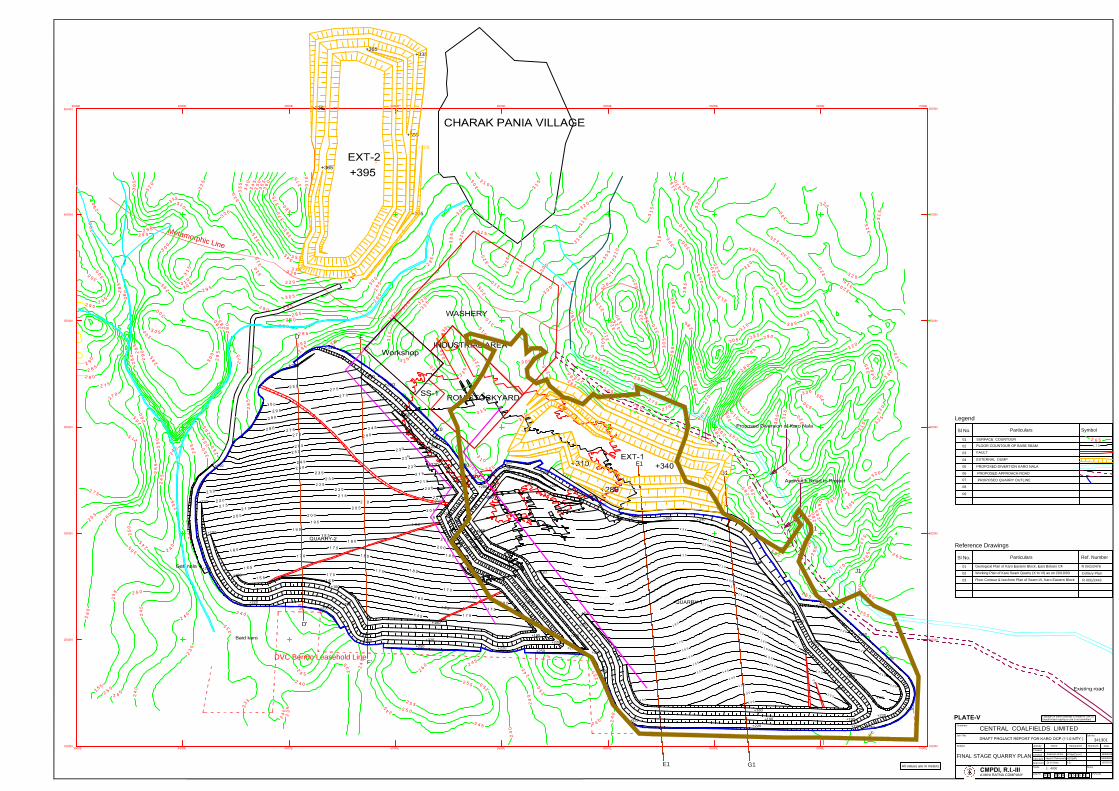
+280
+310
+250
+250
+250
M
e
ta
m
o
r
p
h
ic
L
in
e
DVC Bermo Leasehold Line
01 4
5
5
0
1
1
5
1
1
5
4
1
0
4
0
1
1
1
6
1
6
5
7
0
8
0
1
2
1
5
1
3
0
3
5
0
1
5
5
6
0
1
1
5
1
7
0
6
0
1
1
7
5
1
5
0
1
6
5
0
1
8
9
0
1
8
5
5
1
7
21 5
2
3
5
2
9
1
5
0
0
2
1
0
2
3
2
5
2
0
2
3
0
2
2
0
2
1
0
1
2
2
0
5
5
2
2
5
+300
+290
+280
+270
+260
+250
+240
E1
I1
G1
J1
+242
2
3
5
2
3
5
2
3
5
2
3
5
2
35
2
3
5
24
0
2
4
0
2
4
0
2
4
0
2
4
0
2
4
0
2
4
0
2
4
0
2
4
0
2
4
0
24
0
2
4
0
2
4
5
2
45
2
4
5
24
5
2
4
5
2
4
5
2
4
5
2
4
5
2
4
5
2
4
5
2
4
5
2
5
0
2
5
0
2
5
0
2
5
0
2
5
0
2
5
0
2
5
0
2
5
0
2
5
0
2
5
5
25
5
2
5
5
25
5
2
5
5
2
5
5
2
5
5
2
5
5
2
5
5
2
5
5
2
5
5
2
6
0
2
6
0
2
6
0
2
6
0
2
6
0
2
6
0
2
6
0
2
60
2
6
5
2
6
5
2
6
5
2
6
2
6
5
2
6
5
2
6
5
2
6
5
2
6
5
2
6
5
2
6
5
2
7
0
2
7
0
2
7
0
2
7
0
2
7
0
2
7
5
2
7
5
27
5
2
7
5
2
7
5
2
7
5
2
7
5
2
75
2
7
5
2
80
2
80
2
8
0
28
0
2
8
0
2
8
0
2
8
0
2
8
0
2
8
0
2
8
0
2
8
0
28 0
28
0
2
8
5
28
5
2
8
5
2
8
5
2
8
5
28 5
28
5
2
8
5
2
8
5
2
8
5
28
5
2
8
5
2
8
5
2
8
5
2
9
0
2
9
0
2
9
0
29
0
2
9
0
2
9
0
2
9
0
2
9
0
2
9
0
2
9
0
2
9
0
29
0
2
9
0
2
90
2
9
0
2
9
0
2
90
2
9
5
2
9
5
2
9
5
2
9
5
2
9
5
2
9
5
2
9
5
29
5
2
9
5
2
9
5
2
9
5
2
9
5
2
9
5
2
9
5
2
9
5
2
95
29
5
2
9
5
2
9
5
2
9
5
2
9
5
3
0
0
3
0
0
3
0
0
3
0
0
3
0
0
3
0
0
3
0
0
3
0
0
3
0
0
3
0
0
3
0
0
3
0
5
3
05
3
0
5
3
0
5
3
0
5
30
5
3
0
5
30
5
30
5
3
0
5
3
0
5
3
0
5
3
05
30
5
3
0
5
3
0
5
3
0
5
3
0
5
3
0
5
3
0
5
3
05
3
0
5
3
0
5
31
0
3
1
0
3
1
0
3
1
0
3
1
0
3
1
0
3
1
0
3
1
0
3
1
0
3
1
0
3
1
0
3
1
0
3
1
0
3
1
0
3
1
0
3
1
0
3
1
0
3
1
0
3
1
0
3
1
0
3
1
0
3
1
0
3
1
0
3
1
5
3
1
5
3
1
5
3
1
5
3
1
5
3
1
5
3
1
5
3
1
5
3
1
5
3
1
5
31
5
3
1
5
31
5
3
1
5
3
1
5
3
1
5
3
1
5
31
5
3
1
5
3
1
5
3
1
5
3
2
0
3
2
0
32
0
3
2
0
3
2
0
3
2
0
3
2
0
3
2
0
3
2
0
3
2
0
3
2
0
3
2
0
3
2
0
3
2
0
3
2
0
3
2
0
3
2
0
3
2
0
3
2
0
3
2
0
3
2
0
3
20
3
2
0
3
2
0
3
2
5
3
2
5
3
2
5
3
2
5
3
2
5
3
2
5
3
2
5
3
2
5
3
2
5
3
2
5
3
2
5
3
2
5
3
2
5
3
2
5
3
2
5
3
3
0
3
3
0
3
3
0
33
0
3
3
0
3
3
0
3
3
0
3
3
0
3
3
0
3
3
0
3
3
0
3
3
0
33
5
3
3 5
3
3
5
3
3
5
3
4
0
3
4
0
3
4
5
3
4
5
3
5
0
3
5
0
3
5
5
3
6
0
3
6
5
3
7
0
37
0
3
7
5
3
7
5
3
8
0
D
F
I
3500E
3500E
4000E
4000E
4500E
4500E
5000E
5000E
5500E
5500E
6000E
6000E
6500E
6500E
7000E
7000E
7500E
7500E
1500N 1500N
2000N 2000N
2500N 2500N
3000N 3000N
3500N 3500N
4000N 4000N
4500N
4500N
+310
+310
+250
+220
+280
+280
+250
+250
+250
+250
+220
+220
+220
+250
+250
+220
+220
+220
+220
+250
+220
+220
+190
+160
+160
+190
+160
+220
+220
+
2
2
0
+220
+220
+190
+190
+190
+160
+280
+280
+280
+250
+296
+190
+160
+220
+250
+280
+220
+250
+260
+250
+260
+270
+265
+250
+250
+280
+250
+220
+190
+190
3
1
0
+220
+190
+250
E1G1
D'
F'
Sl No.
Particulars Ref. Number
Reference Drawings
SymbolParticulars
Legend
Sl No.
01
02
03
04
05
341301
All values are in meters.
06
07
08
09
01Geological Plan of Karo Eastern Block, East Bokaro CF
02
Working Plan of Karo Seam Quarry (X to VI) as on 20/10/03
03
Floor Contour & Isochore Plan of Seam-VI, Karo Eastern Block
R III/G/2476
Colliery Plan
R III/G/2442
FINAL STAGE QUARRY PLAN
CENTRAL COALFIELDS LIMITED
DesignationSubject
Job Title
CMPDI, R.I.-III
A MINI RATNA COMPANY
III R
Activity
Checked
Approved
Drg.No.
Created
Scale
Name
0
Rev.No.
Sheet
Signature
Job No.
Date
Customer
0 M
1 : 4000
Created
Copyright in these drawings is vested in CMPDI.
Unauthorised copying or use is not permitted.
O C 0 9 4 1
SURFACE COUNTOUR
FLOOR COUNTOUR OF BASE SEAM
FAULT
EXTERNAL DUMP
PROPOSED DIVERTION KARO NALA
2
65
1 7 0
PROPOSED APPROACH ROAD
PROPOSED QUARRY OUTLINE
Jayant Chakravarty
Dr A Sinha
HOD(MP)
R.D.
Kanchan SinhaSr Mgr(Excvn)
16/3/2013
16/3/2013
16/3/2013
PLATE-V
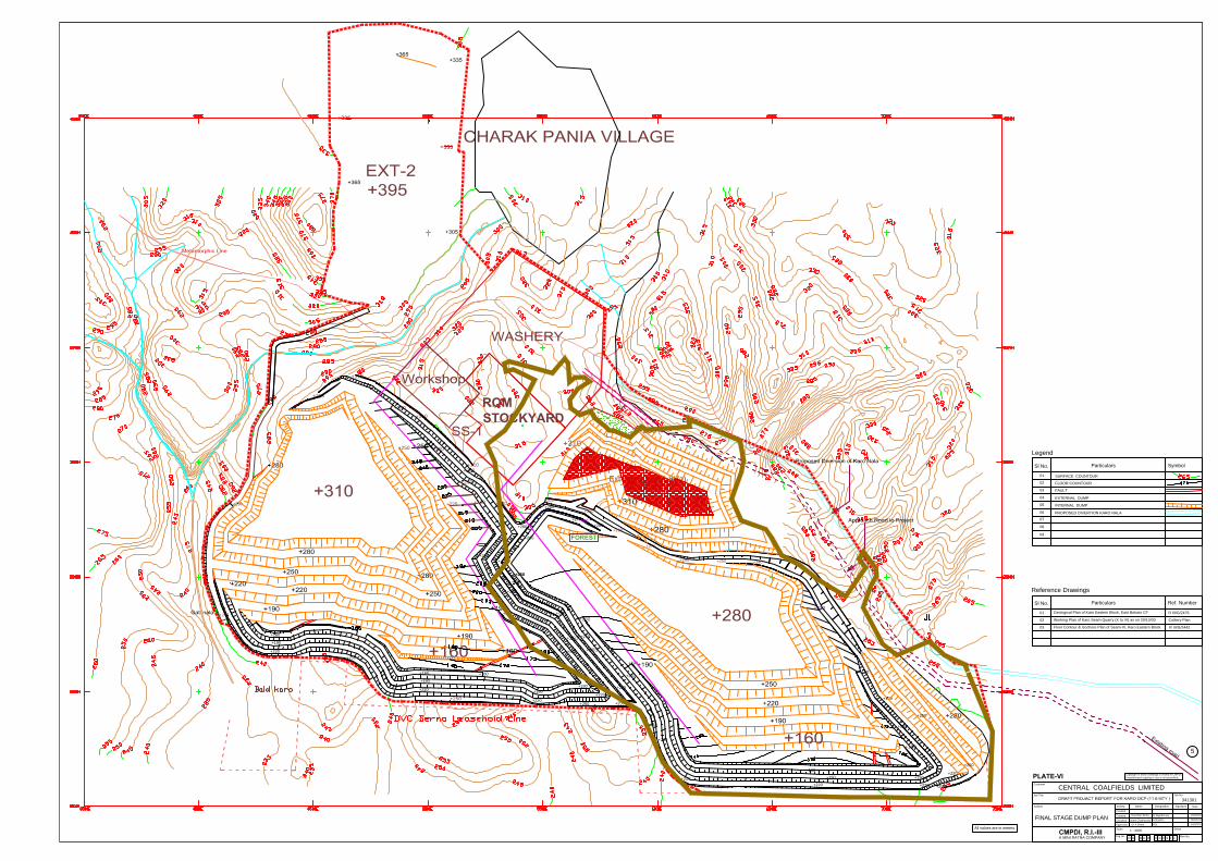
+280
+310
+300
+290
+280
+270
+260
+250
+240
+242
+310
+310
+250
+220
+280
+280
+250
+250
+220
+160
+296
+250
+265
+190
+250
+220
+220
+220
+250
+250
+220
+250
+220
+160
+160
+220
+220
+190
+190
+190
+280
+280
+280
+250
+190
+160
+220
+250
+280
+220
+250+250
+260
+270
+265
+250
+280
+250
+220
+190
+190
+190
+220
+160
+190
+220
+190
+220
+190
Sl No.
Particulars Ref. Number
Reference Drawings
SymbolParticulars
Legend
Sl No.
01
02
03
04
05
341301
All values are in meters.
06
07
08
09
01
Geological Plan of Karo Eastern Block, East Bokaro CF
02Working Plan of Karo Seam Quarry (X to VI) as on 20/10/03
03Floor Contour & Isochore Plan of Seam-VI, Karo Eastern Block
R III/G/2476
Colliery Plan
R III/G/2442
FINAL STAGE DUMP PLAN
CENTRAL COALFIELDS LIMITED
DesignationSubject
Job Title
CMPDI, R.I.-III
A MINI RATNA COMPANY
III R
Activity
Checked
Approved
Drg.No.
Created
Scale
Name
0
Rev.No.
Sheet
Signature
Job No.
Date
Customer
0 M
1 : 4000
Created
Copyright in these drawings is vested in CMPDI.
Unauthorised copying or use is not permitted.
O C 0 9 4 2
SURFACE COUNTOUR
FLOOR COUNTOUR
FAULT
EXTERNAL DUMP
PROPOSED DIVERTION KARO NALA
INTERNAL DUMP
Jayant Chakravarty
Dr A Sinha
HOD(MP)
R.D.
Kanchan SinhaSr Mgr(Excvn)
16/3/2013
16/3/2013
16/3/2013
5
+220
+250
+250
+250
ROM
STOCKYARD
PLATE-VI
+292
FOREST
Ext Dump 'A'(31.8Ha)
+340
+280
+310
Cap-6.0Mcum


+300
+290
+280
+270
+260
+250
+240
+280
+220
+160
+250
+265
+190
+250
+220
+220
+220
+250
+220
+220
+220
+190
+190
+190
+280
+280
+280
+190
+160
+250
+280
+220
+250+250
+260
+270
+265
+250
+280
+250
+220
+190
+190
+220
+190
Sl No.
Particulars Ref. Number
Reference Drawings
SymbolParticulars
Legend
Sl No.
01
02
03
04
05
341301
All values are in meters.
06
07
08
09
01
Geological Plan of Karo Eastern Block, East Bokaro CF
02
Working Plan of Karo Seam Quarry (X to VI) as on 20/10/03
03
Floor Contour & Isochore Plan of Seam-VI, Karo Eastern Block
R III/G/2476
Colliery Plan
R III/G/2442
FINAL STAGE DUMP PLAN
CENTRAL COALFIELDS LIMITED
DesignationSubject
Job Title
CMPDI, R.I.-III
A MINI RATNA COMPANY
III R
Activity
Checked
Approved
Drg.No.
Created
Scale
Name
0
Rev.No.
Sheet
Signature
Job No.
Date
Customer
0 M
1 : 4000
Created
Copyright in these drawings is vested in CMPDI.
Unauthorised copying or use is not permitted.
O C 0 9 4 2
SURFACE COUNTOUR
FLOOR COUNTOUR
FAULT
EXTERNAL DUMP
PROPOSED DIVERTION KARO NALA
INTERNAL DUMP
Jayant Chakravarty
Dr A Sinha
HOD(MP)
R.D.
Kanchan SinhaSr Mgr(Excvn)
16/3/2013
16/3/2013
16/3/2013
5
+250
+250
I
n
f
r
a
s
t
r
u
c
t
u
r
e
PLATE-VI
+292
FOREST
Ext Dump 'A'(31.8Ha)
+340
+280
+310
Cap-6.0Mcum